Tag Archives: Northern Ireland

The Story of Irish Narrow Gauge. … Its Growth and Decay …

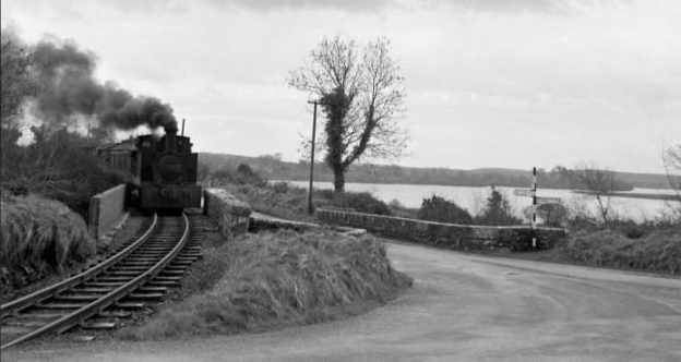
The featured image for this article was taken on the Cavan and Leitrim Railway’s Ballinamore to Arigna branch by James P. O’Dea. on 14th March 1959. This photograph is National Library of Ireland ref.: ODEA 11/30 (www.nli.ie) and is avaiable as (c) Public Domain. [44]

1st February 1961 was a significant date in the history of Irish Railways. It marked the closure of the West Clare Railway, the last survivor of the narrow-gauge lines.
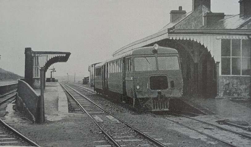
The afternoon train from Ennis to Kilrush is made up of diesel Railcar No. 3388 and a trailer and van. Here it sits at Milton Malbay, on the West Clare section of Coras Impair Eireann on 27th July 1960. Closure of the West Clare section occurred on 1st February 1961, © E. M. Patterson. [1: facing page iv]

The Railway Magazine of February 1961 noted that, “The construction of many of these railways was facilitated by special legislation, designed to relieve the depressed state of large areas of that country some eighty years ago. Although several schemes failed to mature, more than 500 miles of 3 ft-gauge line were built, and over 30 miles of 5 ft. 3 in. gauge were narrowed. To this total must be added the nine miles of so-called “monorail,” on the Lartigue system, from Listowel to Ballybunion. The decline of the narrow gauge began with the advent of motorbus services in rural areas, and its extinction [was] now complete.” [1: p74]
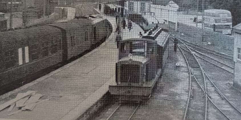
Trains of two gauges at Ennis Railway Station on 22nd September 1960. On the right, diesel mechanical locomotive No. F502 waits to depart for West Clare from the bay platform, while across the platform, a CIE main line train heading to Limerick arrives in the station, © R. N. Joanes and licensed for reuse under a Creative Commons Licence (CC BY-SA 2.0). [2: p75]

The first part of an article on this considerable proportion of the railway mileage of Ireland appeared in the February 1961 issue of The Railway Magazine. [2: p75-83]
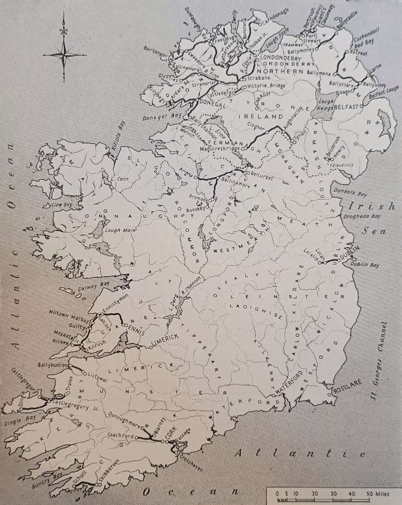
This map shows the relative positions of the Irish Narrow Gauge lines. [2: p76]

Patterson says that, “In the Irish railway framework, the narrow-gauge lines formed an integral part. In no sense freaks, they used a gauge of 3 ft. 0 in. which, though it lacked the Parliamentary blessing of the standard Irish 5 ft. 3 in. gauge, was entitled by usage and by total mileage to be regarded as a secondary standard. Only 9.5 miles of Lartigue monorail in County Kerry was an exception to the rule, and its short existence of 36 years likewise singled it out from the others. The 18 other narrow-gauge systems worked away in self-contained independence, with rolling stock that was nearly as commodious as on the standard gauge.” [2: p77]
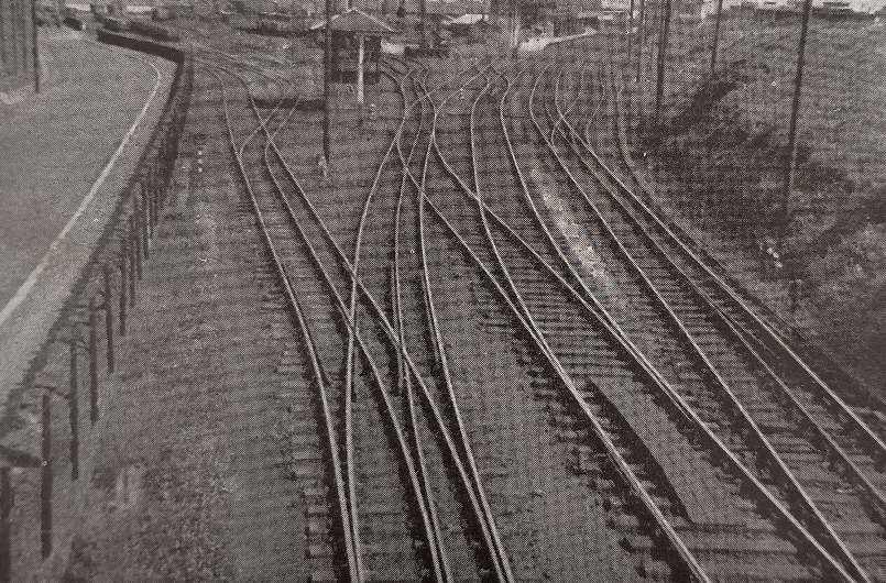
Mixed 5ft 3in gauge and 3ft gauge tracks at Larne Harbour in 1948, © R. E. Tustin. [2: p77]

Patterson continues: “Fittingly enough, the cradle of the Irish narrow gauge was rocked by the mining industry. In the peat-shrouded plateau of County Antrim, the basalt rocks north-east of Ballymena had been shown by geological survey to contain extensive beds of iron ore, and associated with them, accumulations of bauxite. The latter, mined for its aluminium content, was of no interest in the 1870s but iron ore that could be trucked out on to the hillsides was of immediate use to the cross-channel ironmasters. Roads in Antrim were primitive then, and in many of the glens the slipe or slide cart was more often to be seen than wheeled vehicles. Then the boom in iron-ore mining began, and in 1873 the first 3 ft gauge line was made down Glenariff to the sea, linking mines high on the terraced east face of the glen with a pier at the White Arch. It was no fault of the railway that the mines never paid; locally poor-grade ore, and high royalties to the landowner smothered the line, but though it never carried passengers, it was the pioneer.” [2: p77-78]

Apparently, “The first 3 ft gauge railway in Ireland to be authorised by Parliament followed close behind the Glenariff line, as the Ballymena, Cushendall & Red Bay Railway, (BC&RBR). opened in 1875. It ran alongside the 5 ft. 3 in.gauge Belfast & Northern Counties [Railway](B&NCR) main line at Ballymena and was to have conveyed ore to a pier at Red Bay. The descent from the uplands to the coast would have entailed a drop of 1,000 ft. in 5 miles. Probably because of the severe grade this part was never built and the line terminated near its summit level, the station being fittingly named Retreat and situated on moorland honeycombed with iron ore workings. Down at Ballymena, the broad gauge took the ore away for some years, until the Ballymena & Larne came in from Larne Harbour in 1878, and joined the BC&RBR in 1880. The broad gauge B&NCR took the pair of them over in 1884 and 1889.” [2: p78]

“Once the fashion was started by these three narrow-gauge lines in Antrim, similar systems progressed apace. 1877, the Ballycastle Railway Company obtained its Act and made a line from the B&NCR. at Ballymoney to what was then a small fishing port on the rocky northern coast of County Antrim. The line skirted the great flat of the Garry Bog and, after a gentle ascent towards the rounded hills, it started down the Tow Valley to the sea. It never had any prospect of mineral traffic, for it crossed country devoid of ore deposits, but the promoters’ hopes of its developing Ballycastle as a tourist resort were reasonably well fulfilled. With its opening in 1880, the start of a rapid expansion of narrow-gauge mileage had begun.” [2: p78]

Patterson continues,  “The decade 1880-90 witnessed the number of Irish narrow-gauge systems increase from three to 16. This growth was the result both of private enterprise and of state assistance under the Tramways & Public Companies (Ireland) Act of 25th August 1883. Private enterprise put six systems in motion, both steam and electrically hauled.” [2: p78] There were four of the former:

  • The West Donegal Railway – which became part of a much larger network.
  • The Portstewart Tramway, in Co. Derry.
  • The Castlederg & Victoria Bridge Railway, in Co. Tyrone.
  • The Dublin & Lucan Railway, west of the capital.

The two electric lines were:

  • The Giant’s Causeway & Portrush Tramway, in Co. Antrim.
  • The Bessbrook & Newry Tramway , in Co. Armagh.

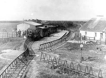
Unique in design, and steam hauled, was the Listowel & Ballybunion, already mentioned as Britain and Ireland’s sole Lartigue monorail. More about the Lartigue can be discovered here. [3]
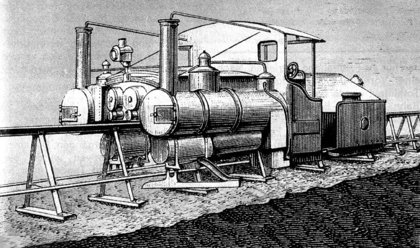
A sketch of the Lartigue locomotive, © Public Domain. [16]
The passing loop at Lisselton, © Public Domain. [16]

The 1883 Tramways Act resulted in six further lines:

  • The Cavan & Leitrim Railway – there is a series of articles on this blog about the lines operated by this company – these can be found here, [4] here, [5] here, [6] here, [7] here, [8] here, [9] here, [10] here, [11] here, [12] and here. [13]
  • The Clogher Valley Railway.
  • The Cork & Muskerry Light Railway.
  • The Schull & Skibbereen Railway.
  • The Tralee & Dingle Light Railway – an introductory article about two books about the line can be found here. [17]
  • The West Clare Railway – a series of articles on this blog about the lines operated by this company – can be found here, [18] here, [19] here, [20] here, [21] here, [22] here, [23] here, [24] and here. [25]

The Act also permitted the West Donegal to complete its line from the unsatisfactory original terminus at Druminnin to Donegal Town. But, the West Donegal struggled financially and in 1892 it amalgamated with the adjacent 5ft 3in gauge Finn Valley Railway (FVR). The merger created the County Donegal Railway Company and within a year or so, the FVR was converted to 3ft gauge.

Similarly the Londonderry & Lough Swilly Railway (L&LSR) was a 5ft 3in gauge railway which also worked a privately sponsored 3ft gauge line – the Letterkenny Railway opened in 1883. By 1885, the decision had been taken to convert the L&LSR to 3ft gauge.

Later expansion came about more slowly. “Sir John Allport’s Royal Commission of 1886 recommended the development of the Irish railways by the furtherance of light railways. The 1889 Light Railways (Ireland) Act was the outcome, and it authorised further state assistance. As a result, the Donegal Railway benefited by the addition of the Donegal-Killybegs and Stranorlar-Glenties sections, totalling 43.5 miles and opened in 1893 and 1894 respectively.” [2: p81]

The 6.5 mile Cork, Blackrock & Passage Railway (CB&PR) replaced its broad-gauge track by 3ft-gauge in October 1900. Under severe competition from the Cork Electric Tramway, the CB&PR extended its lines 9.5 miles, in stages, to Crosshaven (August 1902 to June 1904).

Remaining expansion centred predominantly in County Donegal. A 14.5 line from Strabane down the East side of the valley of the River Foyle gave access to the city and port of Derry. It opened in 1900.

A 15.5 mile branch from Donegal town to Ballyshannon was opened in 1905. In 1906 the Donegal was “bought out by the combined efforts of the GNR(I) and the Midland Railway (Northern Counties Committee) and was thereafter administered by a joint committee,” [2: p81] (the CDRJC).

The 19.5 mile line of the Strabane & Letterkenny Railway Company linked the two towns in 1909. It allowed some freight traffic to be transferred between the two narrow gauge systems in County Donegal.

More about the railways of County Donegal can be found in a series of other articles on this blog. These can be found here, [26] here, [27] here, [28] here, [29] here, [30] here, [31] here, [32] here, [33] here, [34] here, [35] here, [36] here [37] here, [38] here, [39] here, [40] here, [42] here, [43] and here. [44]

Patterson tells us that, “With the opening of the Strabane & Letterkenny line, the construction of passenger-carrying narrow-gauge lines in Ireland was complete, though the fact that the public had not lost interest was evidenced from time to time when local bodies advocated the extension of existing lines.” [2: p82-83] He cited as an example, the deaf ear turned by the CDRJC to local entreaties to extend the Glenties line to Ardara.

One final extension was to be built. 3 miles from the Cavan & Leitrim’s railhead at Arigna (just inside County Roscommon) adits were driven into coal deposits and, as the operation grew, a 4.5 mile extension from Arigna to Dereenavoggy and Aughabehy was opened in June 1920. That extension was, 10 years later cut back to a length of only 1.5 miles. For more about the extension please look here. [4]

During WW1, the British government took control of all Irish railways (December 1916 to August 1921). During those years wages rose by 250%! Fares were raised, doubling in stages. Patterson tells us that, “The slim profits of pre-war days vanished and a combination of higher rail fares, and higher rail freight charges, drove potential customers on to the roads. There, the expanding motor industry was ready to provide vehicles for both public and private transport. The position was the same in Great Britain, but in Ireland the rate of change was restrained by the lack of suitable roads to carry the new traffic.” [2: p83]

Patterson continues: “In the remoter parts of Ireland, where the narrow-gauge lines were situated, and where they had been built by reason of the physical and economic geography, road improvements came slowly. Surfaces in the 1930s were shockingly bad by present day standards, but in spite of the limited amount of money that the county councils had to spend, change was working.” [2: p83]

Politics also intervened: rebellion against British rule broke out in 1916. “By mid-1920, some engine crews were refusing to work trains which carried British troops or munitions and, in the December, this had virtually paralysed rail services in County Donegal and in other parts of the west. The formation of the 26-county Free State in December, 1921, did not end the unrest, for almost two years of civil war followed, during which there was wide-spread damage to rail systems, and train services ceased in Kerry and Cork.” [2: p83]

The new international border which was formed in 1921 and the accompanying customs tariffs adversely affected traffic and trade to the West of Derry.

Patterson continues: “The two companies faced the new situation quite differently. Henry Forbes, managing for the CDRJC, introduced petrol and then diesel railcars, and thereby obtained striking economies in operating costs. By stopping his trains almost anywhere to pick up passengers in the sparsely-peopled country, he gained an unequalled degree of public support. On the Londonderry & Lough Swilly, H. Hunt, and later James Whyte, decided that the future was on the roads and an expanding fleet of omnibuses and lorries began to trade over the north of the county. The contrasted policies were undoubtedly linked with the different ownerships. Behind the CDRJC., the LMS and the GNR (I) were essentially railway minded. The locally owned L&LSR was less traditional and more-over was working a line with stations often miles from the villages.” [2: p96]

After WW1, closures of Ireland’s narrow gauge railways began.

Patterson tells us that, “Three concerns came to an end in the decade between 1920 and 1930. First to go was the monorail between Listowel and Ballybunion. The company had been bankrupt since 1897, damage had been suffered during the ‘Troubles’, and the line had not been included in the Great Southern Railways merger. The concern lacked a profitable future and it was closed in mid-October 1924. … The Dublin & Lucan, altered from 3 ft. to 3 ft. 6 in. gauge in 1896 and electrified about ten years later, went down under bus competition at the end of 1924. It was resurrected by the Dublin United Tramways three years later, but it ceased to be narrow gauge and became linked to the city’s 5 ft. 3 in.-gauge tram system. It lasted thus until 1940.” [14: p169]

Patterson continues: “The Portstewart Tramway Company had only managed to remain solvent from 1882 until 1897. Ownership then went to the Belfast & Northern Counties Railway, passing to the Midland Railway (Northern Counties Committee) in 1903 and the LMS (NCC) in 1923. It functioned merely as a link between the seaside town and the railway station, and it was easily and economically replaced by substitute road services in January 1926.

“Some fifteen miles east of Portstewart, ill fortune had overtaken the Ballycastle Railway Company by 1924, and it closed the line down on 4th April. After some uncertainty, and a summer without trains, the line was taken over by the LMS (NCC) and was reopened in August 1924. Under the new regime, coordination with the neighbouring narrow-gauge lines at Ballymena became possible and some exchange of locomotive and coaching stock resulted. … During the 1930s the old Ballymena, Cushendall & Red Bay section of the NCC ground to a stop. The iron-ore traffic which had started it was finished, as it had become cheaper to import a higher-quality ore from overseas. Passenger traffic ended in October 1930. The line from Rathkenny to Retreat was closed completely in 1937, and the Ballymena to Rathkenny portion three years later.” [14: p169-170]

The formation of the Great Southern Railways incorporated two narrow-gauge lines which served Cork city. “Neither of them went far enough to serve a wide community and they were particularly subject to pressure from road services. The only double-track Irish narrow-gauge section, that from Cork to Blackrock, was singled in 1927 and the system was shut down in two stages during 1933. Two years later it was followed into the shadows by the Cork & Muskerry section, a line remarkable in that it survived the competing electric tramway by three years. … In Tyrone, the Castlederg & Victoria Bridge line had been fortunate in making contact with the Great Northern’s Omagh-Londonderry line. Its roadside position made it a target for its successors, and the end was defined by the 1933 railway strike, for the company never resumed operations after it.” [14: p170]
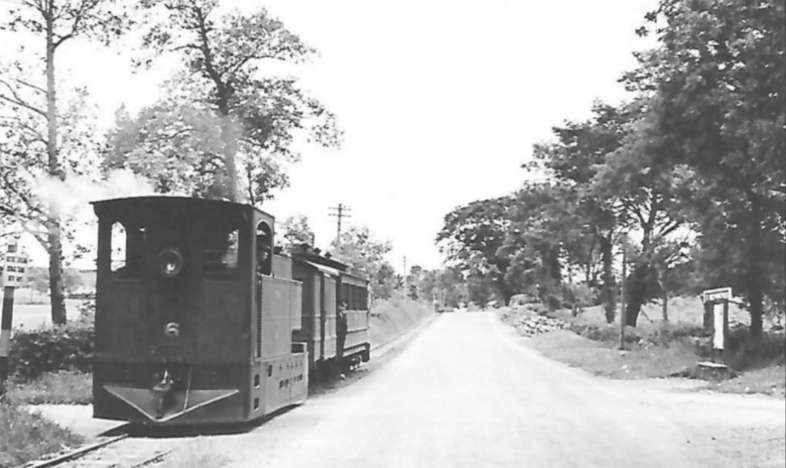
A short mixed train on the Clogher Valley Railway (CVR). The locomotive is CVR No. 6 ‘Erne’, an 0-4-2T built in 1887 by Sharp Stewart & Co., (Works No. 337). It was withdrawn in 1942, © Public Domain. [15]

Patterson tells us that, “The end of the Clogher Valley Railway had been in sight for twenty years before it closed. A 1927 Government enquiry, instituted because of the burden which the CVR was placing on the rates, resulted in the line being placed under a committee of management. The presence of Henry Forbes from the CDRJC produced a temporary rejuvenation, but with the formation of the Northern Ireland Road Transport Board in 1935 bus and lorry competition increased. The end was in sight and the Government ordered the closure at the end of December, 1941.” [14: p170]

On the Ballymena & Larne section of the NCC, passenger services, which included the express boat trains, had been throttled by the strike of 1933. In 1942 working ended on the Ballyboley Junction-Ballymena section and two years later the Ballyclare to Doagh section was lifted. An infrequent service of goods trains continued to operate between Larne and the Ballyclare Paper Mill until July 1950. [14: p170]

This trend of closure continued: the CDRJC lost the Glenties Branch in 1949. The Strabane to Letterkenny line closed at the end of 1954 with the rest of the network gone by 1959. Under the CIE, the Tralee & Dingle and the Cavan & Leitrim were allowed to deteriorate. The Tralee & Dingle had a period when it saw only one good train a month (in connection with Dingle Cattle Fair), but that finally ceased in June 1953. Coal trains from Arigna kept the C&LR branch active until 1959. In the last years of the C&LR, its depot at Ballinamore became a gathering place for narrow-gauge locomotives and rolling stock.

1960 saw a demolition train stripping the rails from the Barnesmore Gap in the heat of summer. The West Clare was struggling on. Patterson goes on to relate, succinctly, the history of the West Clare section which eventually fell as result of the May 1957, 259-page report from a committee of inquiry which stressed the population movement away from rural areas. The report suggested that all Ireland needed “was the main-line skeleton radiating from Dublin, and a cross-country line from Limerick to Rosslare. Clearly, the branches on the 5 ft. 3 in. gauge and what was left of the narrow gauge were redundant.” [14: p175]

In November 1960, “it became known that C.I.E. proposed to close in early 1961, among other minor lines, the West Clare. The announcement was greeted with regret rather than with surprise, for all things considered, it was a little remarkable that the West Clare survived as long as it did. With it [went] the Irish narrow gauge, evolving during nearly ninety years from the little mineral line in Glenariff to a total of around 570 miles of track and then degenerating step by step as social changes and mechanical developments created new conditions which had no use for it.” [14: p175]

References

  1. The Editorial, in The Railway Magazine, Volume 107, No. 718, February 1961.
  2. E. M. Patterson; The Narrow Gauge in Ireland: Its Growth and Decay – 1; in The Railway Magazine, Volume 107, No. 718, February 1961, p75-83 & p96.
  3. https://rogerfarnworth.com/2018/12/31/the-listowel-and-ballybunion-railway.
  4. https://rogerfarnworth.com/2019/04/26/the-cavan-leitrim-railway-arigna-valley-railway/
  5. https://rogerfarnworth.com/2019/05/09/the-cavan-and-leitrim-railway-a-short-history-and-a-look-at-dromod-station/
  6. https://rogerfarnworth.com/2019/05/19/the-cavan-and-leitrim-railway-dromod-to-mohill/
  7. https://rogerfarnworth.com/2019/05/24/the-cavan-and-leitrim-railway-mohill-to-ballinamore/
  8. https://rogerfarnworth.com/2019/05/29/the-cavan-and-leitrim-railway-ballinamore-to-ballyconnell/
  9. https://rogerfarnworth.com/2019/06/07/the-cavan-and-leitrim-railway-ballyconnell-to-belturbet/
  10. https://rogerfarnworth.com/2019/06/15/the-cavan-and-leitrim-railway-the-arigna-tramway/
  11. https://rogerfarnworth.com/2019/07/01/the-cavan-and-leitrim-railway-a-miscellany/
  12. https://rogerfarnworth.com/2023/04/28/the-cavan-and-leitrim-cl-railway-again-belturbet-railway-station/
  13. https://rogerfarnworth.com/2024/12/27/the-cavan-and-leitrim-railway-at-dromod-again/
  14. E. M. Patterson; The Narrow Gauge in Ireland: Its Growth and Decay – 2; in The Railway Magazine, Volume 107, No. 719, February 1961, p169-175.
  15. https://picryl.com/media/clogher-valley-railway-1093b4, accessed on 17th October 2026.
  16. https://en.wikipedia.org/wiki/Lartigue_Monorail, accessed on 17th October 2026.
  17. https://rogerfarnworth.com/2023/07/09/the-tralee-dingle-railway.
  18. https://rogerfarnworth.com/2019/04/08/the-west-clare-railway-part-1-ennis-to-corofin/
  19. https://rogerfarnworth.com/2019/04/15/the-west-clare-railway-part-2-corofin-to-lahinch/
  20. https://rogerfarnworth.com/2019/04/20/the-west-clare-railway-part-3-lahinch-to-miltown-malbay/
  21. https://rogerfarnworth.com/2019/04/30/the-west-clare-railway-part-4-miltown-malbay-to-quilty/
  22. https://rogerfarnworth.com/2019/05/05/the-west-clare-railway-part-5-quilty-to-moyasta/
  23. https://rogerfarnworth.com/2019/05/09/the-west-clare-railway-part-6-moyasta-to-kilkee/
  24. https://rogerfarnworth.com/2019/07/07/the-west-clare-railway-part-7-moyasta-to-kilrush-and-cappagh-pier/
  25. https://rogerfarnworth.com/2019/07/16/the-west-clare-railway-part-8-a-miscellany/
  26. https://rogerfarnworth.com/2024/05/16/the-lough-swilly-railway-continued-letterkenny-to-derry-part-1/
  27. https://rogerfarnworth.com/2024/05/27/the-lough-swilly-railway-continued-letterkenny-to-derry-part-2/
  28. https://rogerfarnworth.com/2026/10/22/the-lough-swilly-railway-continued-letterkenny-to-derry-part-3/
  29. https://rogerfarnworth.com/2024/09/14/the-llsr-once-again-a-perspective-from-the-19th-century-the-railway-magazine-november-1899/
  30. https://rogerfarnworth.com/2020/05/27/co-donegal-railways-ireland-part-1-the-glenties-branch-stranorlar-to-ballinamore/
  31. https://rogerfarnworth.com/2020/06/22/co-donegal-railways-ireland-part-2-the-glenties-branch-ballinamore-to-glenties/
  32. https://rogerfarnworth.com/2020/06/12/co-donegal-railways-ireland-part-3-petrol-railmotors/
  33. https://rogerfarnworth.com/2020/07/27/co-donegal-railways-ireland-part-4-strabane-to-letterkenny-part-a-strabane-to-raphoe/
  34. https://rogerfarnworth.com/2020/10/05/co-donegal-railways-ireland-part-5-strabane-to-letterkenny-part-b-raphoe-to-convoy/
  35. https://rogerfarnworth.com/2020/10/29/co-donegal-railways-ireland-part-6-strabane-to-letterkenny-part-c-convoy-to-letterkenny/
  36. https://rogerfarnworth.com/2023/04/26/teelin-bay-teelin-pier-and-co-donegal-railways/
  37. https://rogerfarnworth.com/2023/04/30/the-donegal-railway-heritage-centre/
  38. https://rogerfarnworth.com/2023/06/26/the-donegal-railway-heritage-trail/
  39. https://rogerfarnworth.com/2023/09/10/derry-history-the-harbour-tramways-railways/
  40. https://rogerfarnworth.com/2023/04/28/the-burtonport-extension-of-the-londonderry-lough-swilly-railway-part-1/
  41. https://rogerfarnworth.com/2023/05/05/the-burtonport-extension-of-the-londonderry-lough-swilly-railway-part-2/
  42. https://rogerfarnworth.com/2024/04/30/the-burtonport-extension-of-the-londonderry-amp-lough-swilly-railway-part-3/
  43. https://rogerfarnworth.com/2023/07/13/the-burtonport-extension-of-the-llsr-londonderry-and-lough-swilly-railway-part-4-barnes-gap-to-letterkenny/
  44. https://picryl.com/media/i-see-the-train-a-coming-a-coming-down-the-line-17256090891-393fc9, accessed on 22nd October 2026.
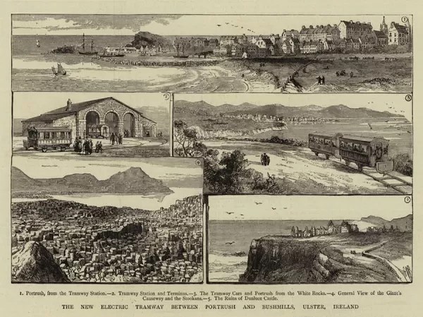
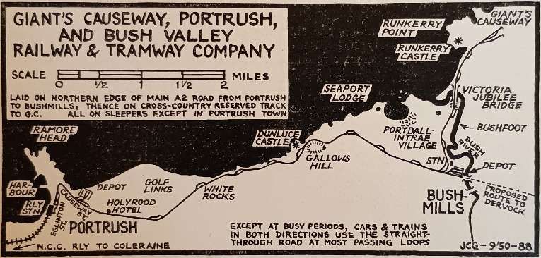
The Giants’ Causeway and Portrush Tramway – The Modern Tramway, Vol. 13 No. 153

In the Summer of 2024, my wife and I visited Giants’ Causeway as part of a few days meandering along the North coast of Ireland. When reading a series of older copies of the Modern Tramway, I came across an article written in 1950. … The Modern Tramway of September 1950 featured an article by D. G. Evans about one of the very early electric tramways – The Giants’ Causeway and Portrush Tramway. His article is quoted in full in this article.

Wikipedia tells us that The Giants’ Causeway, Portrush, & Bush Valley Railway & Tramway was a “pioneering 3 ft (914 mm) narrow gauge electric railway operating between Portrush and the Giant’s Causeway on the coast of County Antrim, Northern Ireland. The line, 9 1⁄4 miles (14.9 km) long, was hailed at its opening as ‘the first long electric tramway in the world’. [2] The Giant’s Causeway and Bushmills Railway today operates diesel and steam tourist trains over part of the Tramway’s former course.” [3]

The Giants’ Causeway, Portrush, & Bush Valley Railway & Tramway. [24]

Writing in 1950, Evans says that:

“The recent decision of the shareholders to close down the Giant’s Causeway tramway was sad news to those who knew the line and can recall the pleasure of breezy rides along the cliff tops in the qua’nt cars that had seen but little change since their first day of operation. The line was the first tramway in the United Kingdom to be operated by electricity and the current was produced by a hydro- electric power station at Walkmills, one mile from the Bushmills terminus. A waterfall on the river Bush was the source of the hydro-electric power.

Opened from Portrush station to Bushmills in January, 1883, the line was extended to the ultimate terminus at Giant’s Causeway in 1887. The original current collection was from a side conductor rail 17in. above ground and 22in. from the inside running rail. This method was of course unsuited to a street tramway and the portion of the line which ran in the centre of the street through the town of Portrush was therefore worked by steam tram engines of the usual vertical boiler pattern. This method of operation of the first half-mile of the tramway persisted until 1899, when a change over to the overhead trolley system was made. From that date until 1915 the steam tram engines were retained for use during the peak traffic periods in the summer at which time the original power station proved inadequate for the needs of the system.” [1: p185]

The Giants’ Causeway, Portrush, & Bush Valley Railway & Tramway Company. [1: p 185]
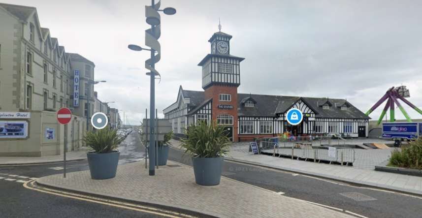
The Portrush Railway Station in the 1890s. The tramway terminus is in the foreground and on the left of this image, © W. Lawrence, Public Domain. [4]
A similar view in the 21st century. [Google Streetview, July 2023]

Wikipedia gives some of the background to the opening of the line: “The Giant’s Causeway Tramway came about through the enthusiasm of William Atcheson Traill, M.A.Ing., of Ballylough (1844–1934), together with his brother Dr Anthony Traill, who between them undertook most of the promotion and fundraising for the line. W.A. Traill was a man with not only an interest in railways but also a keen interest in technological developments in engineering. The Act of Parliament incorporating ‘The Giant’s Causeway, Portrush, and Bush Valley Railway and Tramway Company’ was passed on 26th August 1880. It authorised a tramway from Portrush to Bushmills and a railway from there to join the Ballycastle Railway (also 3 ft. gauge) at Dervock. The only section of the railway never built was a short spur at Dervock. [5] The Dervock section was abandoned by an 1885 Act, which authorised extension from Bushmills to the Causeway.” [3][6]

“At the Berlin Trade Fair of 1879 Siemens was demonstrating the first railway electrification system and it was that which led the British branch of the firm to be commissioned to incorporate this new technology into the Giant’s Causeway Tramway venture. Sir William Siemens (1823–83) was briefly a Director and Siemens Brothers of London were appointed electrical engineers to the company, their representative being Dr Edward Hopkinson, who later went on to work on the Bessbrook and Newry Tramway and the City & South London Railway. Surveying and civil engineering work was carried out by Edward Price, son of the eminent Irish civil engineer James Price.” [3]

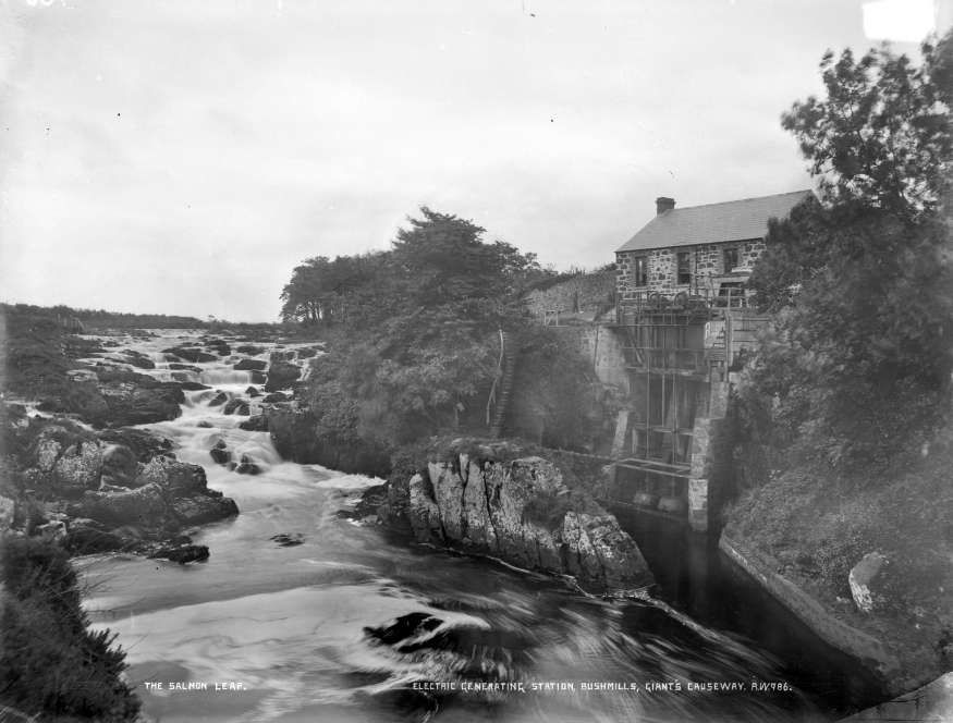
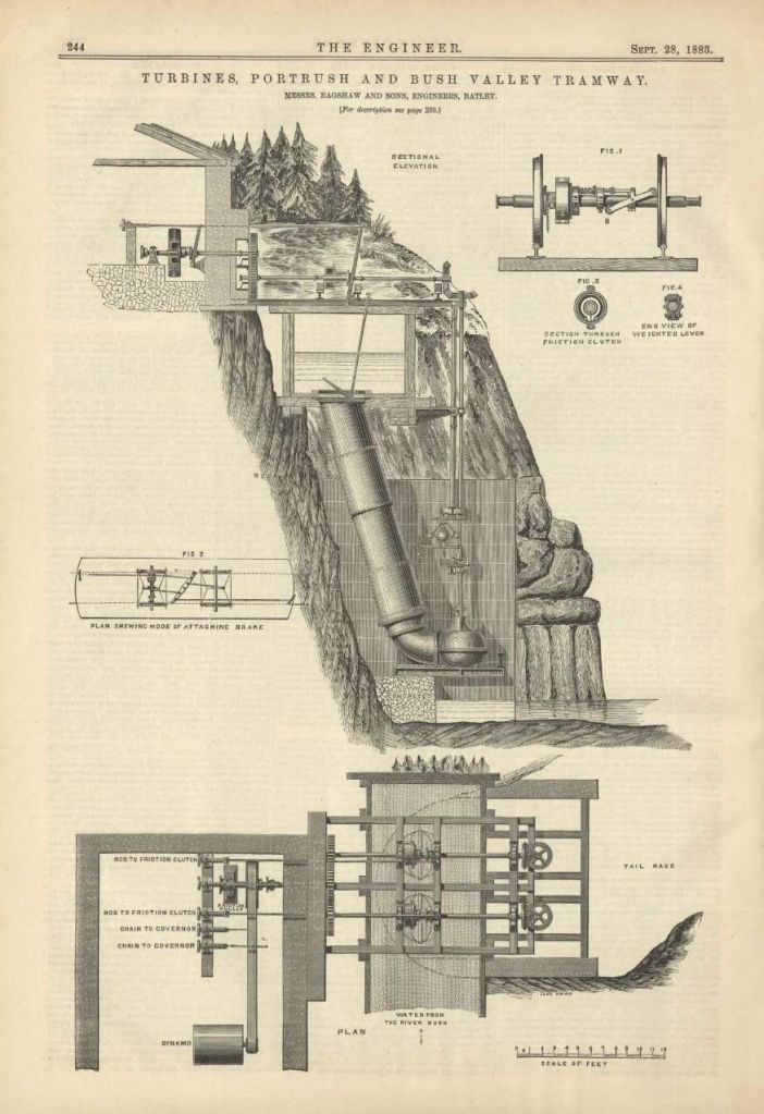
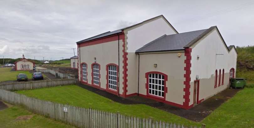
“The line was the world’s first to be powered by hydroelectricity, something that was later developed at Bessbrook and in Switzerland. Traill built a generating station at Walkmill Falls (24 feet (7.3 m)) head), near Bushmills, installing 104 horsepower (78 kW) Alcott water turbines to produce up to 250 volts at 100 amps of electrical power for his line. Later 160 horsepower (120 kW) turbines were installed. [8] This building, although without its equipment, is still in existence.” [3]

The hydroelectric scheme at Walkmills, © Unknown. [25]
A diagrammatic representation of the hydro electric scheme as included in The Engineer, Vol. 56, 1883,© Public Domain. [25]

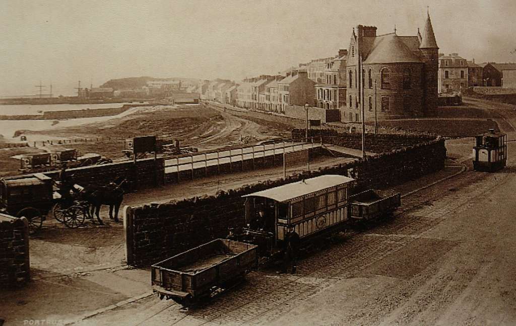
“Because of legal problems over water rights, erection of the Walkmills turbines was delayed and when the first section of the tramway, from Portrush to Bushmills, was opened on 29th January 1883 some of the timetabled passenger traffic was handled by steam tram engines which were in any case necessary on the town section in Portrush where it was impossible to provide electric power since this was originally fed to the trains via an elevated third rail which ran alongside the line. Therefore, a 25 horsepower (19 kW) steam generator was installed at the Portrush depot, [9] (by 1936 replaced by a 550 volt diesel generator for the Portrush-Dunluce section).” [3]

The tramway at Portrush – a steam tram can be seen on the right ▶️ f this week mage, © Public Domain. [18]

“The ceremonial opening, using electric traction, took place on 28th September 1883 although a full scheduled electric service did not begin until 5th November and steam locomotives remained available for use until at least 1926.” [3] In 1897, of the annual mileage travelled, “17,797 miles (28,641 km) were steam operated and 4,721 miles (7,598 km) electric. In 1901 the figures were 7,423 miles (11,946 km) and 23,550 miles (37,900 km) respectively. Very little use of steam was made after 1916.” [3]

Evans tells us that:

“In 1915, the Portrush power plant was installed and the two remaining steam engines were kept as stand-by equipment for use in the event of electricity failures. They were finally sold in 1930 to a public works contractor.

The voltage was 550 d.c., the Portrush plant supplying the Portrush-Dunluce section and the original station outside Bushmills the remainder of the line. Laid to the 3ft. gauge, the line was 7.5 miles in length, single track throughout with loops at irregular intervals.

The loops were normally run through on the landward line, the other line being used only when it was necessary to pass another car. All points (except those at the Portrush terminus which were tramway section) were of light railway type, controlled by dolly-weighted point levers which normally held the rails set for the direct (or landward) line.” [1: p185]

Wikipedia tells us that “the section from Bushmills to the Giants’ Causeway opened on 1st July 1887. In 1895, a cyclist died of electric shock after coming into contact with the conductor rail. At the subsequent inquiry it was revealed that the line voltage varied from an average of 290 V up to 360 V, and the company agreed to a temporary reduction in the voltage, which limited the number of services that could be electrically worked. The third rail was replaced by overhead electric wire using side poles from 26th July 1899, apparently initially at 250 V. Voltage drop remained a problem and the tram was the subject of a song by the Irish Rovers which comments on its slow speed. The song was written by Hugh Speers of Bushmills. [10] After upgrading of the Bushmills generating station in 1907 it was possible to produce a 550 V output.” [3]

Evans continues:

“As the wiring was double and followed the rails through the gantry type standards at loops, it followed that the trolley pole had to be changed from the wire normally used (the landward wire) to the seaward wire when a loop was to be used pass another tram. The writer has often seen this trolley changing performed whilst the cars her were at full speed on a downward grade and has marvelled at the dexterity with which the trolley wheel was placed on the opposite wire. The operation was also seen when the cars were descending the long hill outside Portrush. It seemed usual to lower the trolley bo boom west of White Rocks loop to the Holyrood Hotel. and coast from a point just West of White Rocks loop to the Holyrood Hotel.

The Portrush terminus was outside the N.C.C. (formerly B. & N.C.R.) station and consisted of a run-round loop and lay-by siding in Eglinton Street. At one time there was a short branch which diverged just beyond the loop and ran down to the Harbour, but this was taken up about 1893.” [1: p185-186]

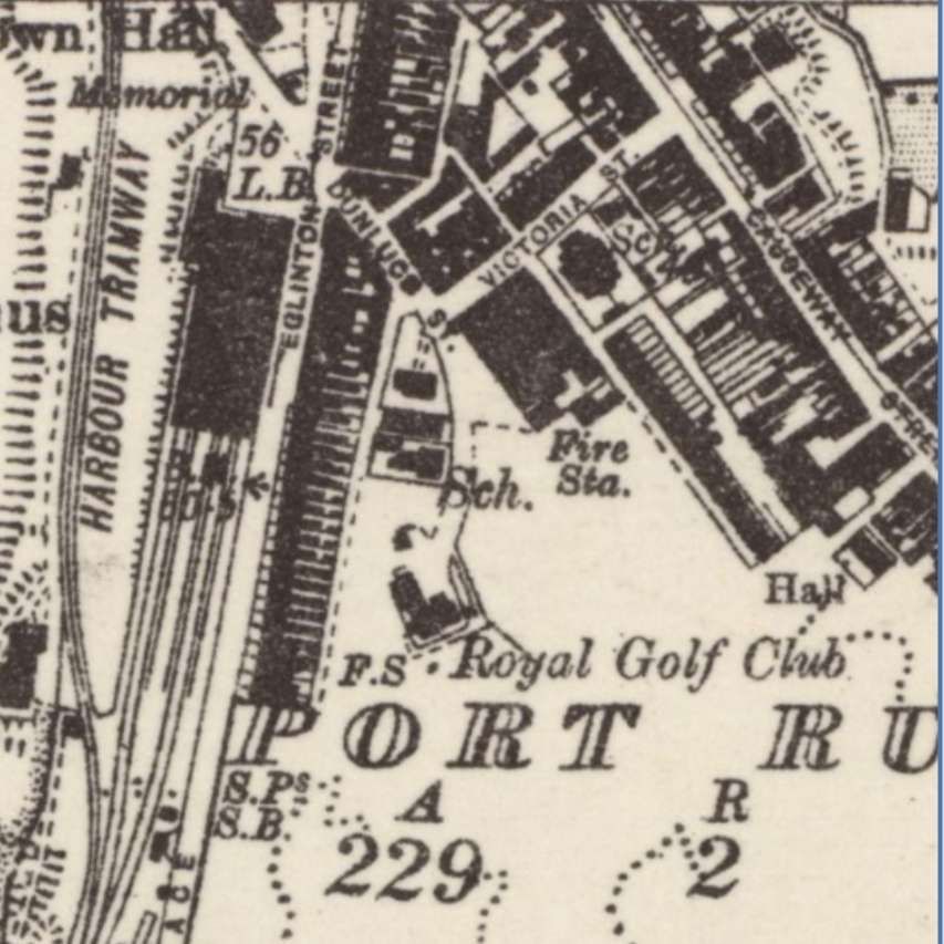
The main line station at Portrush appears in this map extract from the 6″ Ordnance Survey revised 1931 and published in 1934. The tramway terminus can be seen in Eglington Street. A harbour tramway can be seen on the West side of the Station. The Giants’ Causeway tramway ran North on Eglington Street before turning sharply to the right.[19]
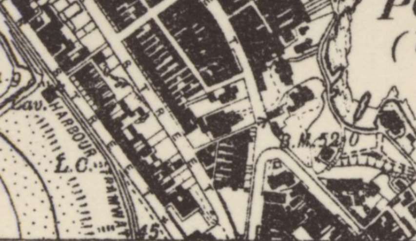
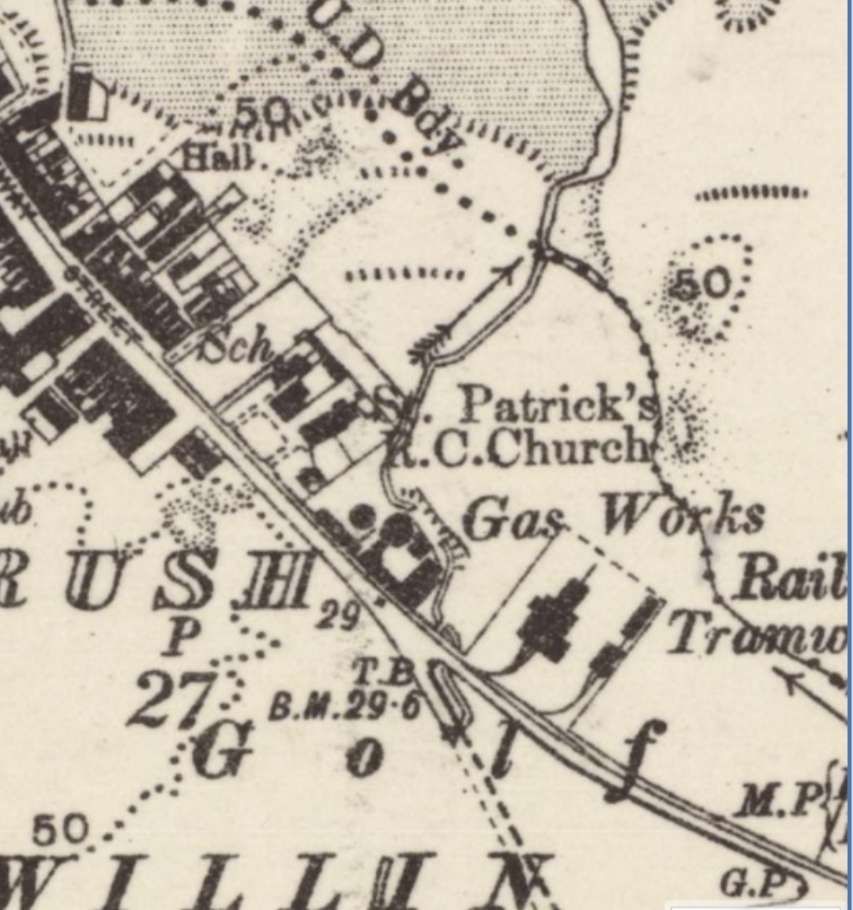
The sharp turn to the right can be seen at the bottom of this extract from the 6″ Ordnance Survey. This is a different map sheet to the one above, also revised in 1931 but published in 1935. The tramway ran Southeast on Causeway Street. [20]
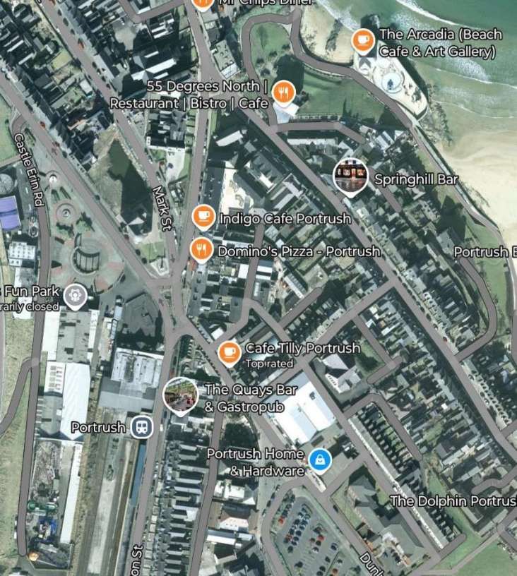
The area of Portrush covered by the map extracts above, as it appears on 21st century satellite imagery. The station is on the left, alongside Eglington Street, Causeway Street runs Southeast from close to the top-centre of the image. [Google Maps, January 2025]
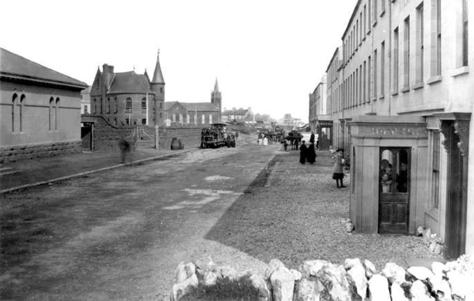
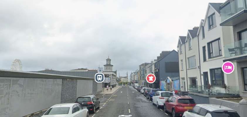
Eglington Street looking North with the railway station on the left and a tram in the centre of the image, © Public Domain. [21]
Looking North along Eglington Street with the railway station on the left. [Google Streetview, July 2023]
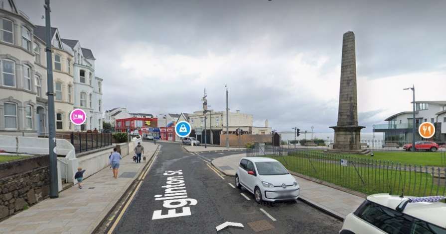
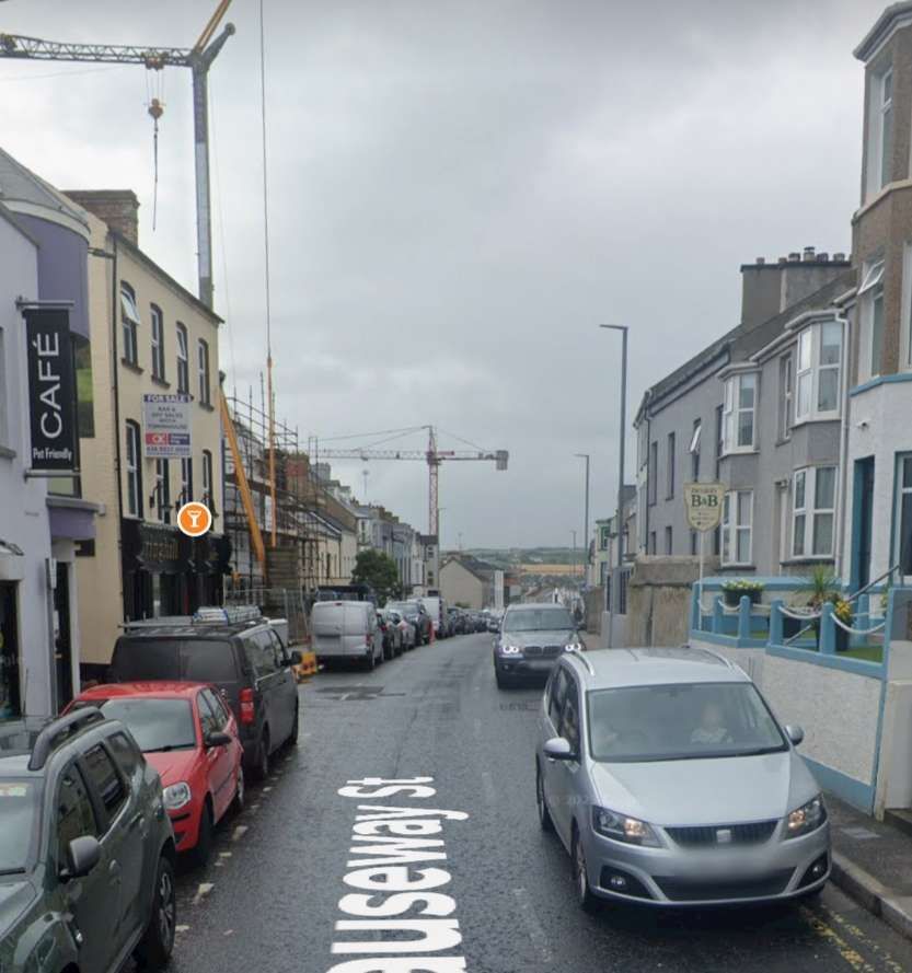
The tramway turned sharply to the right at the junction shown in this photograph. The road beyond the memorial and leaving the right side of the image, is Causeway Street which the tramway followed out of town. [Google Streetview, July 2023]
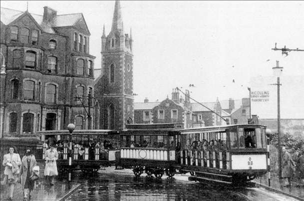
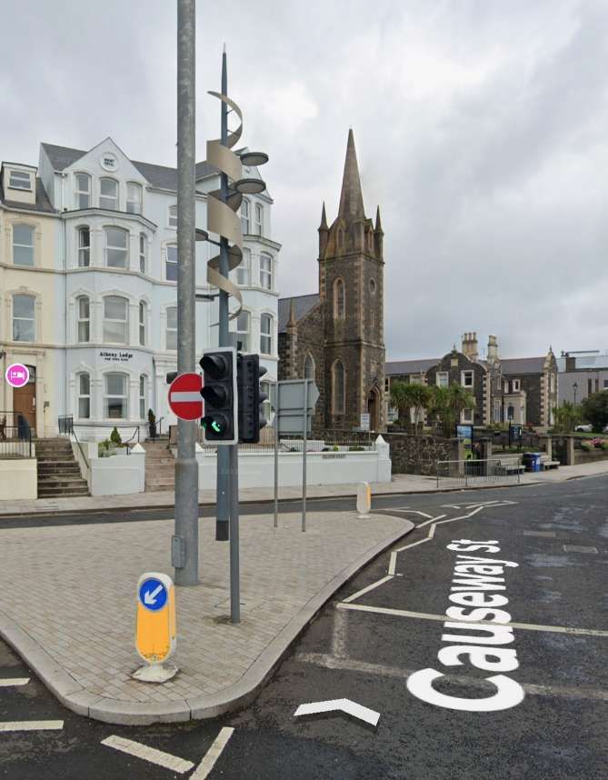
A tram negotiating the tight curve close to the Methodist Church in Portrush, © Unknown. [21]
A very similar view in the 21st century. [Google Streetview, July 2023]
Looking Southeast along Causeway Street in the 21st century. [Google Streetview, July 2023]
Causeway Street led out of Portrush to the Southeast. The Gas Works sat on the North side of the tramway with the tramway depot just to the East. The depot was provided with two connections to the tramway. [19]
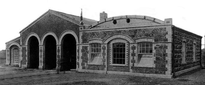
Looking North from Causeway Street at the tram depot building, © Public Domain. [21]

Evans continues:

“For a short distance, the line ran due north before turning in a 75-degree curve into Causeway Street. The single track was of tramway section rails as far as the outskirts of the town. From a point near the depot the line was laid on flat-bottom light railway track on the seaward side of the Portrush-Bushmills road. The depot consisted of a dead end road with a permanent way yard at one side. The auxiliary power station was also here. This power station had a modern diesel plant installed in latter years.

After leaving the depot the line ran through open country on its roadside reservation. Climbing steadily, it passed the famous Royal Links and at White Rocks gained the cliff tops. Onward to Dunluce, the trams ran close to the sea and in places the cliffs fell almost sheer from the trackside. There can be no doubt that the tramway, with its open toast-rack cars, was the best means of appreciating this wild and rugged coast.” [1: p186]

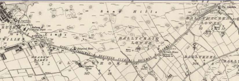
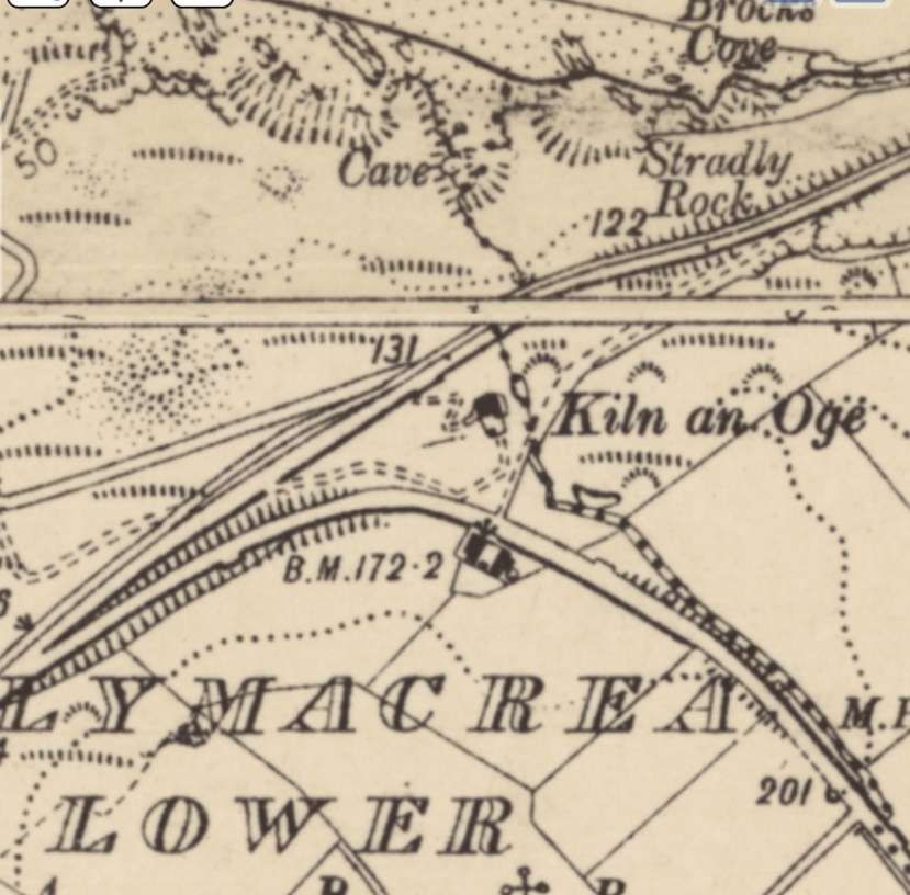
The tramway depot can be seen on the left side of this extract from the 6″ Ordnance Survey revised in 1931 and published in 1934. Top-right of the extract the tramway is back very close to the coast. [19]
White Rocks and the coast are just to the North of the edge of the map sheet. [22]
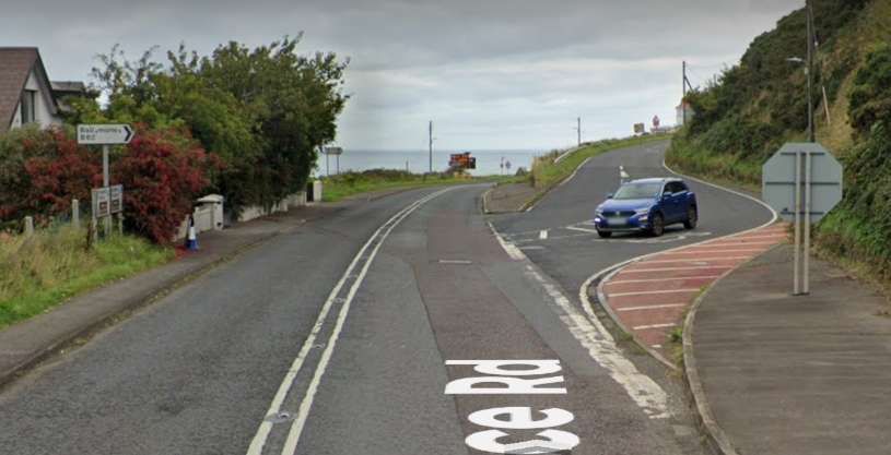
The junction on the left of the map extract is shown in this view which looks Northeast towards the sea. [Google Streetview, September 2022]
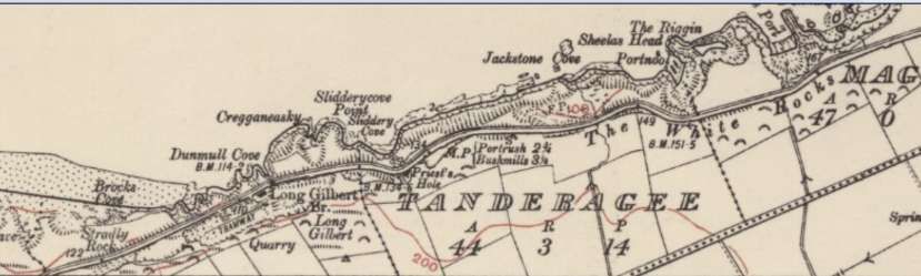
The tramway ran East along the coast and the White Rocks.[20]
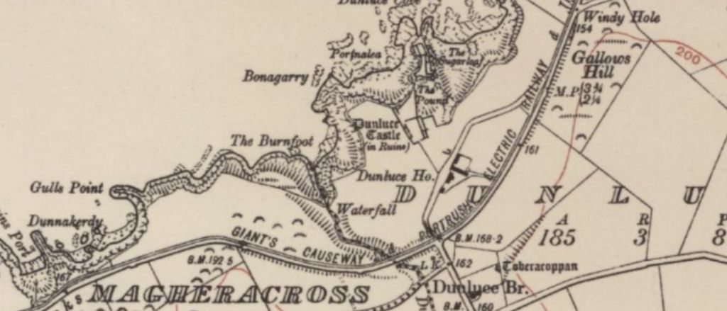
Beyond the White Rocks it ran a little further from the cliff edge passing on the landward side of Dunluce Castle and Dunluce House and then on the seaward side of Gallows Hill. [20]
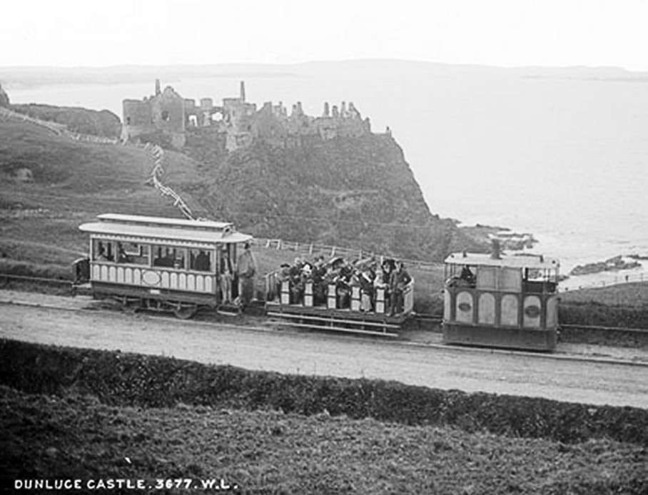
A steam-powered tram runs towards the Causeway and is seen here passing Dunluce Castle in 1890, © W. Lawrence, Public Domain. [3]

Evans continues, again:

“Before reaching Dunluce, the tramway climbed to its highest point at Clooney Hill. This section, nearly 200ft, above the sea, abounded in sharp curves, gradients of 1 in 40 and even a short stretch of 1 in 30.

Beyond Dunluce, the line ran inland for a short distance below Gallows Hill, reaching the coast again at its most spectacular point. Here one could gaze down 140ft. to the foam-covered rocks below. From this point the line again ran inland and after three more passing loops reached Bushmills, a village known for its whisky. Bushmills had a light railway station provided with waiting room, luggage office and lavatories.” [1: p,186-187]

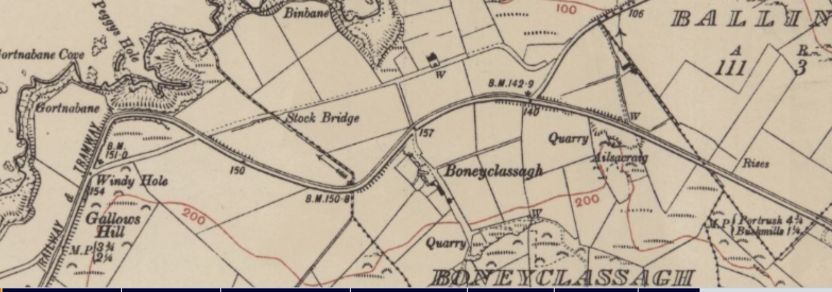
The tramway dropped back to the cliff edge at Gortnabane Cove and Peggy’s  Hole before turning inland. [20]
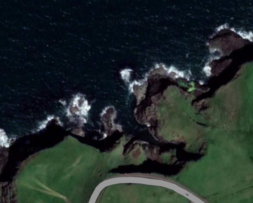
Gortnabane Cove and Peggy’s Hole as they appear on Google Maps. [Google Maps, January 2025]
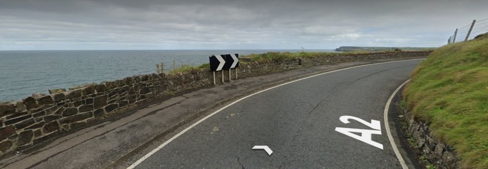
The view out to sea from the sharp bend on the A2 which appears on the satellite image above. The tramway ran along this section of road. [Google Streetview, September 2022]
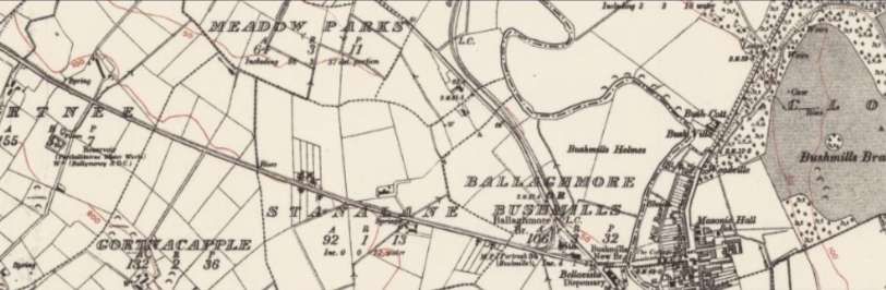
Turning away from the coast the tramway headed for Bushmills. This is the next 6″ OS Sheet to the East. It was revised in 1921 and published in 1935. [23]
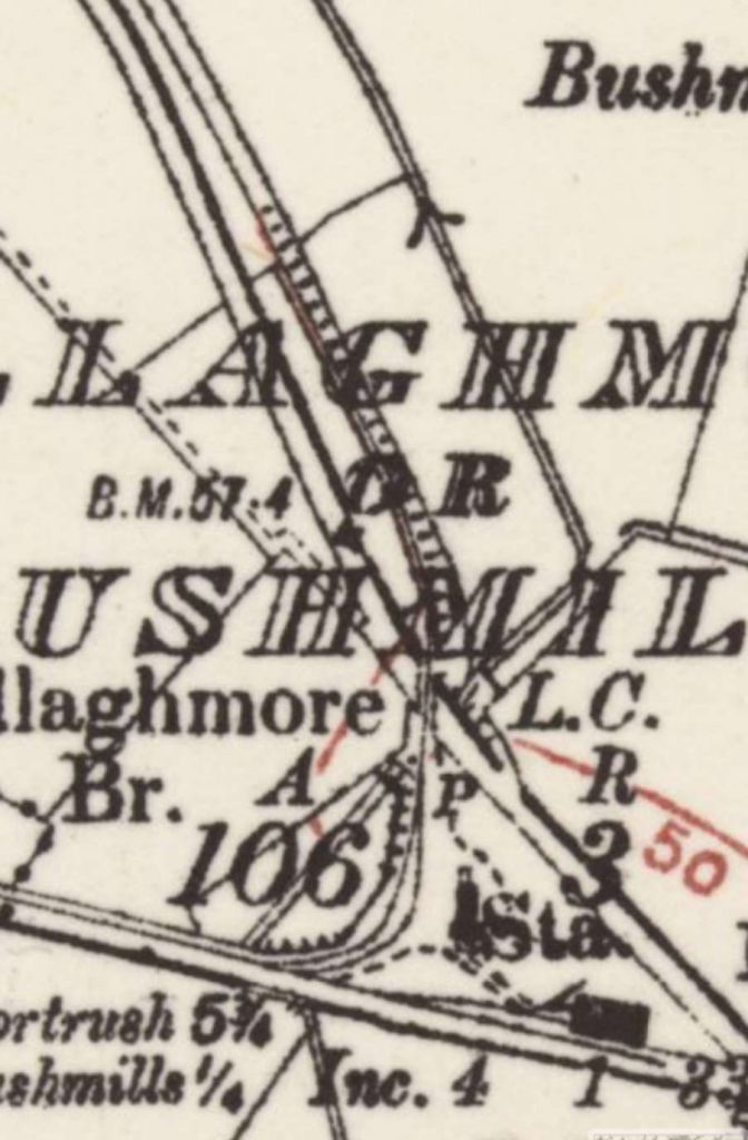
A close up of the station at Bushmills (bottom-right). The branch to the Giants’ Causeway runs away North at the West end of the station site. The road to the South side of the station became the A2. [23]
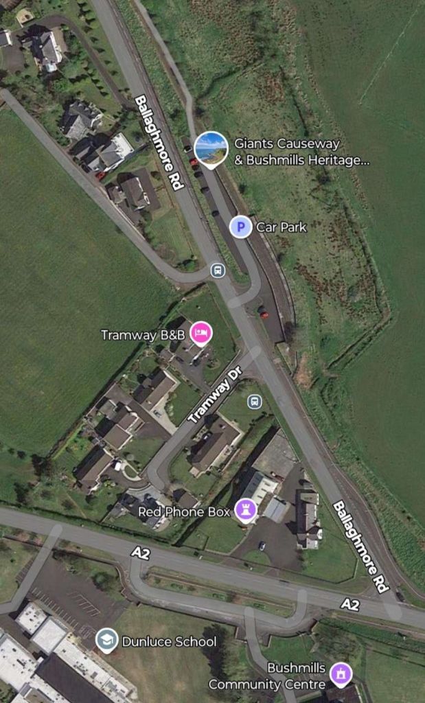
The same location in the 21st century. The station occupied the area between the A2 and Ballaghmore Road. The tramway serving the Giants’ Causeway headed away to the North on a curve just to the West of the station building which is now a private home. The building show under the lilac flag for a Red Phone Box straddles the line of the old tramway. The tramway then crossed Ballaghmore Road before turning the Northwest to run adjacent to the road. [Google Maps, January 2025]
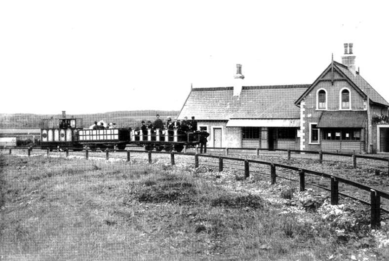
A tram on the curve heading off to the left of the door image for Giants’ Causeway, the original station was located off to the right of this image alongside the modern A2, © Public Domain. [21]
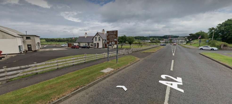
The location of the old Bushmills Tram Station. The station buildings are now a private home. [Google Streetview, June 2023]

Evans continues:

“At one side of the station yard is a small tram shed with accommodation for two cars. The line to the car shed is of interest in that it was to have formed the beginning of an extension to Dervock on the 3ft. gauge Ballycastle Railway. It was with a view to through running with the latter railway that the narrow gauge was adopted for the electric line. The owners wisely decided that an extension to the Causeway would probably be more remunerative.

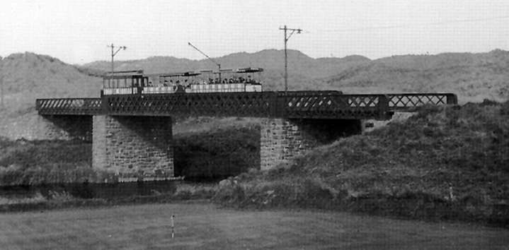
From Bushmills the line was completely private right-of-way and negotiated cuttings and embankments of railway proportions. After passing a loop, the Bushfoot Golf Links request halt was reached. Soon after this, the line crossed the Bush river by the impressive Victoria Jubilee Bridge, a three-span structure so named because it was erected in 1887.” [1: p187]

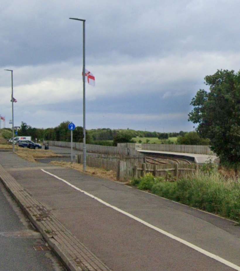
Looking North from Ballaghmore Road along the line of the old tramway. A modern standard gauge tourist line makes use of the formation of the old tramway from this level caution to its old terminus close to the Giants’ Causeway. The station platform for this modern railway can be seen on the right side of this image.  The tourist line was still in operation in December 2024. [Google Streetview, June 2023]
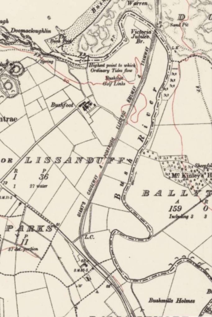
The line North of Bushmills ran on an independent formation over private land. For a distance it ran on the Northeast side of Ballaghmore Road before turning to the Northeast. It ran on the Northwest side of Bush River to the Victoria Jubilee Bridge. This is the 6″ Ordnance Survey again, revised in 1921 and published in 2935. [23]
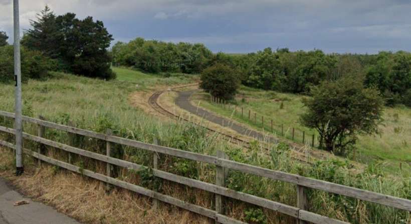
The line ahead, at the end of the modern station car park. A footpath closely follows the line of the railway. [Google Streetview, June 2023]
For a few hundred metres the line runs parallel to Ballaghmore Road. It then turns away to the Northeast running across open country. [Google Streetview, June 2023]
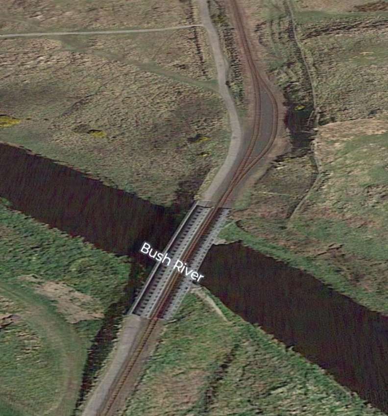
The Victoria Jubilee Bridge was a fine lattice girder structure, carried on masonry piers, the centre span was 70 feet long and about 25 feet above the river. The extension to the Causeway opened in 1887 and as this was Queen Victoria’s golden jubilee year, Mr Traill named the bridge ‘The Victoria Jubilee Bridge’. It was constructed by P & W MacLennan at their Clutha Iron Works in Glasgow, the bridge withstood the test of time facing as it did Atlantic storms and sea spray.  It was finally demolished by the army in the 1970’s and replaced by a footbridge – now since itself replaced – by a new railway bridge for the heritage railway,© Public Domain. [21]
The relatively new replacement bridge over the River Bush as it appears on Google Earth (3D). The heritage line has a passing loop  on the North side of the river. [Google Earth, January 2025]
The 11.30am on 14th August 2012 from Bushmills passing the little-used (and rusty) Bushfoot Golf Links loop bound for the Causeway. This section, close to the public path and Bushfoot golf course is passed at walking pace, © Albert Bridge and licensed for reuse under a Creative Commons Licence (CC BY-SA 2.0). [26]

And, Evans again:

“On the other side of the bridge the line passed through sandhills and rabbit warrens, reaching the coast again and following it for a short distance before finally turning inland for the last time. There were two loops between the Victoria Bridge and the terminus; the layout at this latter point consisted of a run-round loop and a siding. The passenger accommodation was unpretentious, consisting merely of a shelter. The tourist had still almost a mile to walk before reaching the Causeway itself, and here, as is usual in such places, he has to pay for admission.” [1: p187]

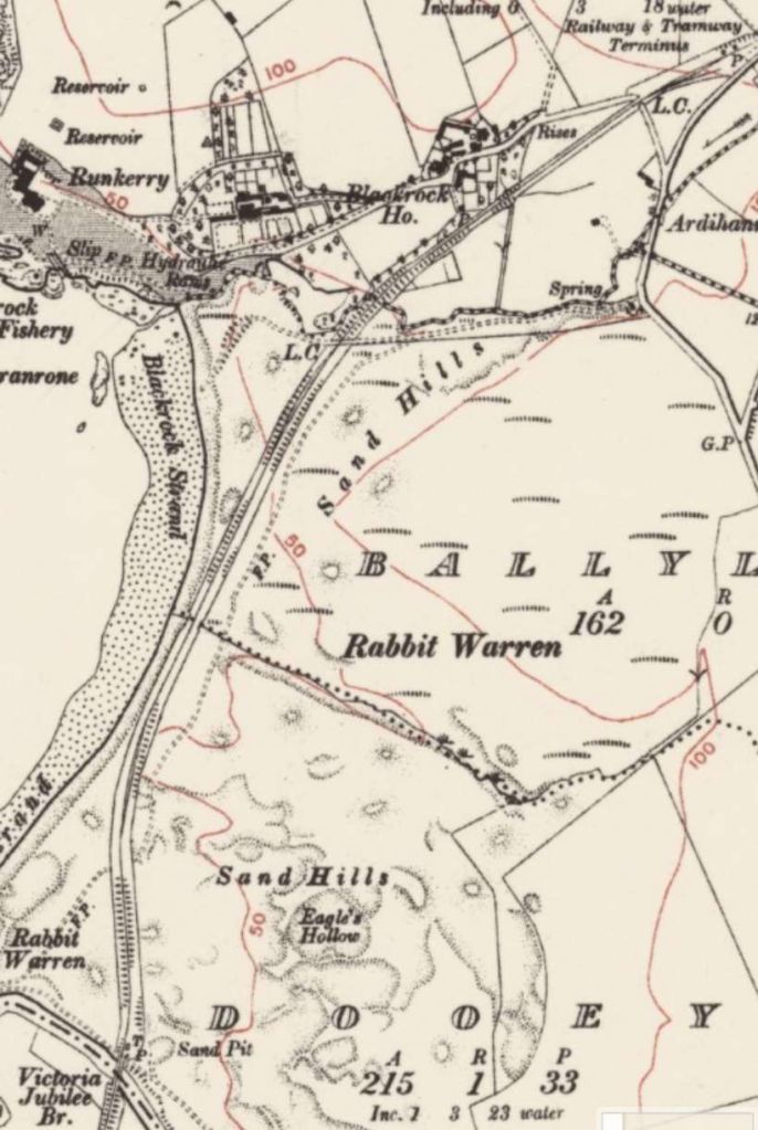
This extract from the 6″ Ordnance Survey shows the remaining length of the line. The terminus is shown in the top-right of the image. [23]

Discover Portrush describes the last part of the journey, thus: “the tram would run behind Black Rock Strand for about half a mile before turning right and climbing towards the Causeway Terminal. On the left passengers would see Runkerry House, a fine red sandstone house constructed in a striking location. Then part of the McNaughten Estate, occupied by two unmarried McNaughten ladies – later it became a home for the elderly after being passed to the government in lieu of death duties. Later still, it became an outward bound centre and is now divided into apartments.” [21]

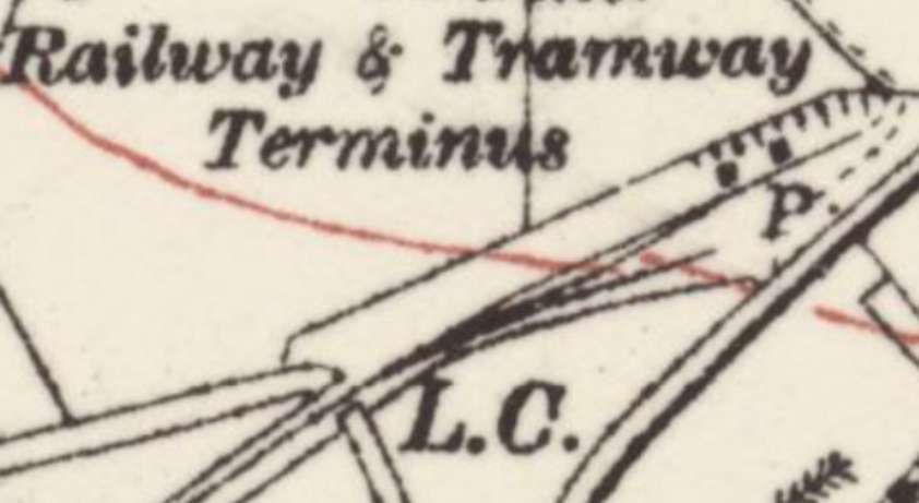
An enlarged detail from the OS map above showing the Causeway terminus of the line. [23]
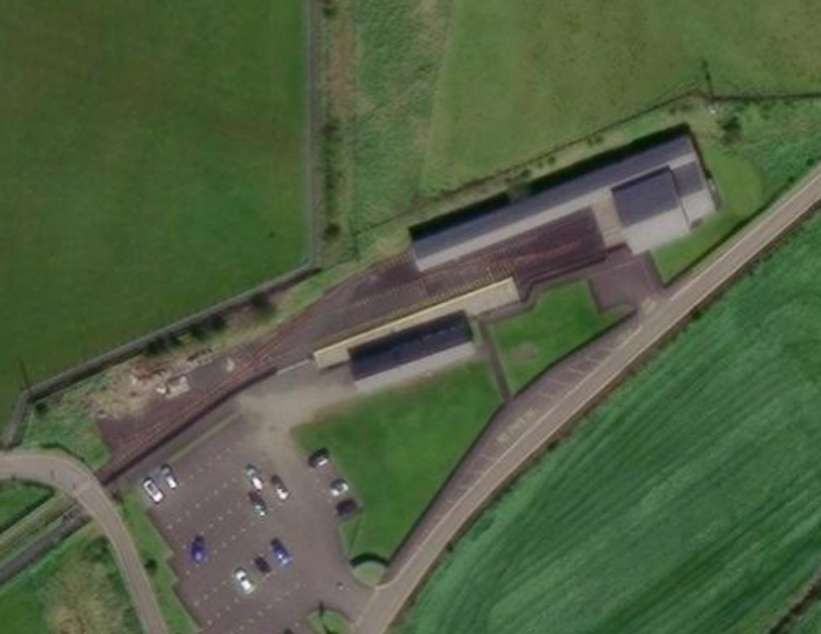
The terminus of the modern preservation line sits on the site of the old terminus. It has a slightly more significant footprint! [28]
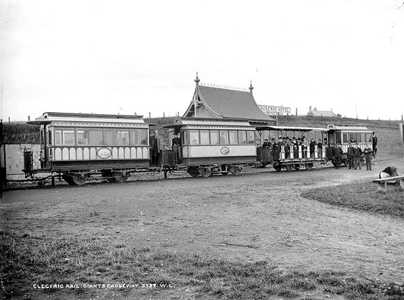
A number of carriages/trailers standing at the Causeway Hotel terminus of the line, © W. Lawrence, Public Domain. [7]
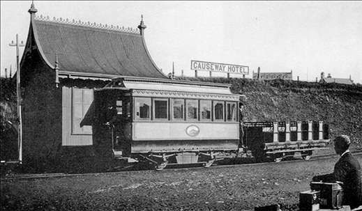
Another view of the terminus. The unique tramway terminal building was constructed of corrugated iron (known locally as ‘wriggly tin’) and served as both booking office and waiting room. It had a steeply pitched roof curving up to a sharp point when viewed on the gable and had been purchased in and brought from Switzerland at a cost of £400, © Public Domain. [21]

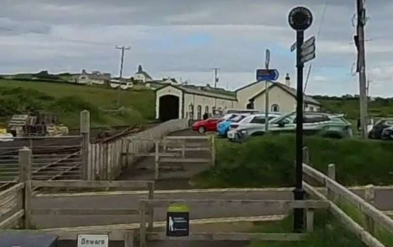
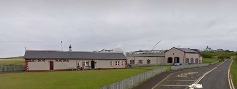
The next three views show the modern preservation line’s buildings in the early 21st century.

The first of these three views shows the approach to the stationary from the Southwest.vThe second is a panorama of the station site and the third looks into the Station site from the East. [Google Streetview, September 2011]

Operation

Evans describes the operation of the original line:

“The somewhat tortuous route along the cliff tops gave the line a reputation for scenery rather than speed, but high speeds were frequently attained on the long falling gradient between White Rocks and the Portrush depot.

When the full summer service was operating, the lengthy sections between passing loops rendered operation difficult, and, as some of the loops were not visible from each other, boy signallers were employed. These boys were supplied with white and red flags which they would display to the drivers from a convenient vantage point, the red flag calling on an eastbound car and the white a westbound

The small shed at Bushmills was used by the morning tram from the village which left, with a load of school children and others, to journey into Portrush before the main service started from the depot The winter service was extremely meagre and did not continue beyond Bushmills out to the Causeway unless three or more passengers booked through to that point. During the summer peaks five sets (of one motor car and two trailers) were often in operation at one time.” [1: p187-188]

Wikipedia tells us that “Traill, a former geological surveyor, expected a considerable mineral traffic between quarries along the line and Portrush harbour, and there was originally a goods branch into the main square of Bushmills. However, this traffic fell away, the narrow gauge harbour branch being taken up when the Northern Counties station was opened in 1893, [11] and for most of its life the line primarily served tourists visiting the Causeway. From 1925/26 the line was closed down during each winter.” [3]

“Increased patronage, partly from military traffic, during World War II meant a brief revival of winter services, but receipts were becoming inadequate to support maintenance of the company’s ageing assets, and the line did not reopen after the end of the 1949 season (last day of regular service 30th September 1949), [12] and was subsequently dismantled.” [3]

Rolling Stock

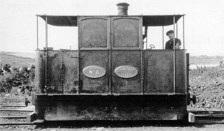
The original power on the line was a series of four steam locomotives built by Wilkinsons. This is their Steam Tramway Locomotive ‘Dunluce Castle’ (No. 3) which served on the line until well into the first half of the 20th century. Delays to the construction of the hydroelectric plant meant that in the first instance steam needed to be used on the tramway Indeed, the need for steam remained significant in to the 29th century as water use for generating sufficient electricity to meet demand could not be fully guaranteed, © Public Domain. [21]

Evans provides details of the rolling-stock used on the line:

“The steam locomotives were Nos. 1 and 2 (1883) (scrapped 1910 and 1899 respectively), Nos. 3 and 4 (sold 1930).

The electric stock was all single deck, single truck:

Nos. 1, 2, 10 (closed trailers with end platforms).

Nos. 4-7, 11, 13, 15, 16 and 19 (toast-rack trailers with canopies).

No. 9 (vestibuled motor-car 2 x 20 h.p. B.T.H. motors. Peckham truck),

Nos. 20-23 (toast-rack motor-cars with canopies, originally completely open).

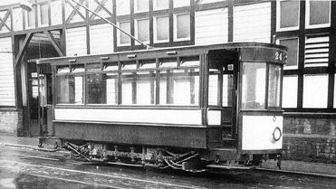
No. 24 (vestibuled motor-car, Peckham pendulum truck, originally double deck 3ft 6in. gauge car and purchased as such from Dunfermline and District Traction Co., August, 1937. It had longitudinal cushioned seats).” [1: p188]

A typical consist on a loop on the tramway, © J. H. Meredith, most probably now Public Domain. [1: p188]

Wikipedia expands somewhat on the rolling-stock record provided by Evans: “the original cars were built by the Midland Railway Carriage and Wagon Company and were later followed by 5 examples from GEC, each with 2 x 20 horsepower (15 kW) British Thomson-Houston motors, and also a Peckham car. There were a maximum of six electric power cars owned at any one time, all being single-truck, single-deck vehicles with both enclosed and “toast rack” examples; typically these would haul several 4-wheel “toast rack” trailers, of which there were 15. There were four steam tram engines, ordered from Wilkinson of Wigan. They had vertical boilers, weighed 7 tons and burnt coke. No.2 was scrapped in 1899, No.1 converted to a ballast wagon in 1910 and Nos. 3 (Dunluce Castle) and 4 (Brian Boroihme) were sold in 1930 for the River Bann Navigation works near Portstewart.” [3][11]

“In 1938 a final electric tram was added to the stock as number 24. This vehicle was formerly a double deck Dunfermline and District Tramways car which was both re-gauged and extensively modified to become a single decker with enclosed ends for the Giants Causeway route.” [3][14]

The modified Dunfermline tram which was given the number 24. It was once a double-deck tram and ran originally on a different gauge. [21]

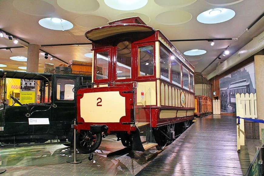
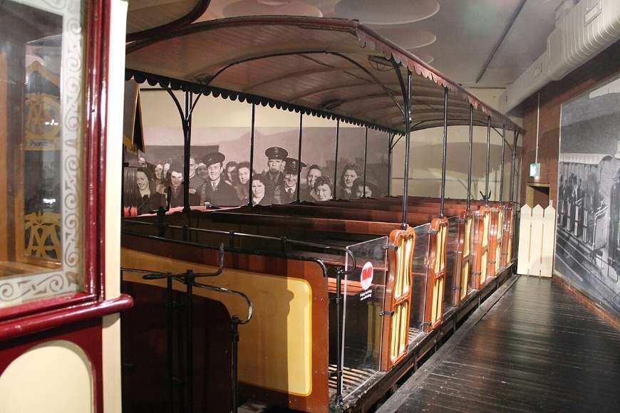
“A power car and trailer are restored at the Ulster Folk and Transport Museum, Cultra and another power car is in the care of the National Transport Museum of Ireland at Howth.” [3]

A motorised tramcar on display at Cultural, © Milepost98 and licenced for use here under a Creative Commons Licence (CC BY-SA 4.0). [15]
A trailer car on display at Cultural, © Milepost98 and licenced for use here under a Creative Commons Licence (CC BY-SA 4.0). [16]

Full details of the steam locomotives can be found here. [17]

Evans concludes:

“The disappearance of this historic tramway, which changed so little in its 66 years of operation, yet provided a useful amenity, and an attraction for tourists, will be mourned by many and the line will be greatly missed by holidaymakers who have in previous years enjoyed rides along its scenic coastal route.” [1: p188]

The editor of The Modern Tramway commented: “We understand that a conference of local authorities is being held to urge the Government to subsidise the Giants Causeway line to the amount of £2,000 a year, so that it may be carried on as a tourist attraction. This is a move that commands our support, but we submit that the modernisation of the line might after a while actually render the subsidy unnecessary.” [1: p188]

Preservation

The Giants’ Causeway and Bushmills Railway was later constructed over the final two miles (3.2 km) of the Tramway and carried its first passengers at Easter 2002. Trains were running at least until the end of 2024. [3][13]

The Giant’s Causeway and Bushmills Railway (GC&BR) is a 3 ft (914 mm) narrow gauge heritage railway operating between the Giant’s Causeway and Bushmills. It “uses equipment originally assembled by Lord O’Neill for a tourist line at Shane’s Castle, Country Antrim, which closed in 1994. The idea of using this to revive part of the Tramway was largely conceived and promoted by David Laing. The Giant’s Causeway and Bushmills Railway Company is a not-for-profit organisation with charitable status. Clearance of the trackbed commenced at the end of 1999 and the railway carried its first passengers at Easter 2002.” [27]

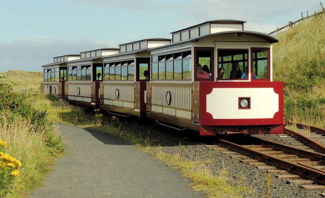
“On 10th July 2010 the railway took delivery of a specially customised 4 coach diesel multiple unit capable of accommodating up to 90 passengers. Manufactured by Severn Lamb UK Ltd., it was designed to enhance the visitor experience to the North Antrim Coast and to recreate, in so far as was possible, the passenger experience of the original hydro electric tram. Commissioning of the new rolling stock by the manufacturers began on Monday 12 July with the inaugural journey three days later. The DMU is powered by a Kubota V3600-E3 engine and shares the line with the previous steam rolling stock. All vehicles run on bogies. The power vehicle is on the Causeway side and is shorter (4 windows) than the three trailers (5 windows).” [27]

Rolling Stock

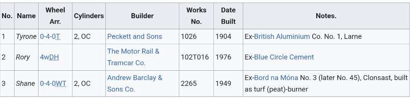
In addition to the 4-coach DMU, the line has three locomotives and a number of coaches.

The Locomotives owned by the preservation line. [27]

References

  1. D. G. Evans; The Giants’ Causeway and Portrush Tramway; in The Modern Tramway Vol. 13 No. 153, London, September 1950, p185-188.
  2. Railway Times; 22nd September 1883. (Cited by the article at Reference No. 3)
  3. https://en.m.wikipedia.org/wiki/Giant%27s_Causeway_Tramway, accessed on 17th January 2025.
  4. https://commons.m.wikimedia.org/wiki/File:Portrush_Rly_Station,_1890s.jpg, accessed on 16th January 2025.
  5. Railway Magazine. May 1936. p. 355. (Cited by the article at Reference No. 3)
  6. Railway Magazine. May 1936. p. 360. (Cited by the article at Reference No. 3)
  7. https://commons.m.wikimedia.org/wiki/File:Giant%27s_Causeway_tram,_Causeway_Hotel.jpg, accessed on 17th January 2025.
  8. Railway Magazine. May 1936. p. 359. (Cited by the article at Reference No. 3)
  9. Railway Magazine. May 1936. p. 356. (Cited by the article at Reference No. 3)
  10. David Hammond; The Singer’s House. Greenhays GR702, 1980, sleeve note.
  11. Railway Magazine. May 1936. p. 361. (Cited by the article at Reference No. 3)
  12. Irish Railway Record Society Journal, no. 9; Smmer 1951, p140.
  13. https://m.facebook.com/profile.php/?id=100063607388865, accessed on 17th January 2025.
  14. https://discoverportrush.com/buildings/transport-travel/giants-causeway-tramway, accessed on 17th January 2025.
  15. https://commons.m.wikimedia.org/wiki/File:Cultra_a7.jpg, accessed on 17th January 2025.
  16. https://commons.m.wikimedia.org/wiki/File:Cultra_a12.jpg, accessed on 17th January 2025.
  17. http://www.trainweb.org/i3/lbld_wi.htm#loco_wi_c, accessed on 17th January 2025.
  18. https://itoldya420.getarchive.net/amp/media/the-giants-causeway-tram-at-portrush-in-built-up-areas-was-initially-the-steam-6740ac, accessed on 17th January 2025.
  19. https://maps.nls.uk/view/247678121, accessed on 17th January 2025.
  20. https://maps.nls.uk/view/247678106, accessed on 17th January 2025.
  21. https://discoverportrush.com/buildings/transport-travel/giants-causeway-tramway, accessed on 17th January 2025.
  22. https://maps.nls.uk/geo/explore/#zoom=16.5&lat=55.20428&lon=-6.60729&layers=6&b=ESRIWorld&o=100, accessed on 18th January 2025.
  23. https://maps.nls.uk/view/247678112, accessed on 28th January 2025.
  24. https://www.mediastorehouse.co.uk/fine-art-finder/artists/english-school/new-electric-tramway-portrush-bushmills-23543986.html, accessed on 18th January 2025.
  25. https://www.ulstertransportmuseum.org/collections/causeway-tram, accessed on 18th January 2025.
  26. https://www.geograph.org.uk/photo/3083952, accessed on 19th January 2025.
  27. https://en.m.wikipedia.org/wiki/Giant%27s_Causeway_and_Bushmills_Railway, accessed on 19th January 2025.
  28. https://maps.nls.uk/geo/explore/#zoom=18.0&lat=55.23149&lon=-6.51811&layers=6&b=ESRIWorld&o=0, accessed on 19th January 2025.