Monthly Archives: Sep 2017

The Flour Mill Colliery

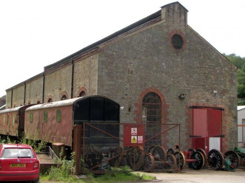
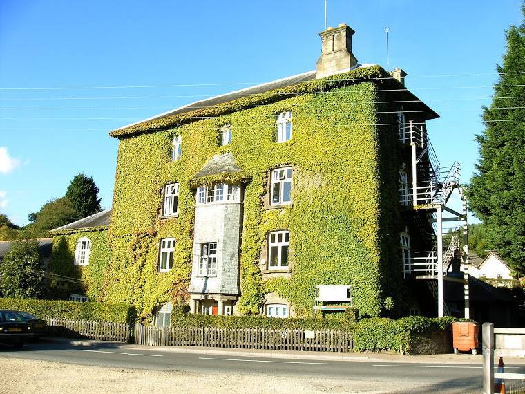
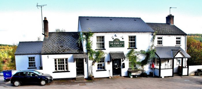
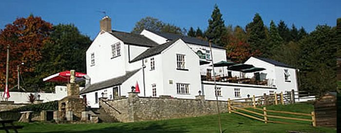
Today, one of the Flour Mill Colliery buildings is still in use as ‘The Flour Mill Ltd’. The company is engaged principally in the repair and overhaul of steam locomotives, although it undertakes other railway-related activities such as the valuation of historic locomotives and luxury train operations. Owned and managed by William Parker, who had previously kept working engineering alive at Swindon after British Rail Engineering Ltd closed, the business occupies a workshop converted from a historically-listed colliery electricity generating station.

Bream-Flour-Mill-01

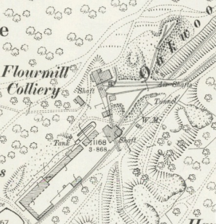
The colliery was known as the Flour Mill, presumably because the way to it from the village of Bream passed the Oakwood water mill. There is no evidence of a flour mill ever being directly on the site of the colliery, and no known association with flour or milling. However the colliery was at one time the largest employer in Bream, and most families originating from the village have one or more relative or ancestor who worked there.

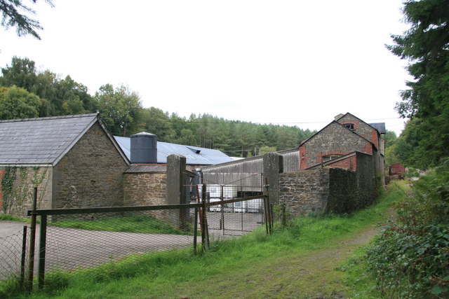
The site, and subsequently the building, have been used for a multitude of activities. It was originally part of a royal hunting forest. Later no doubt oaks for the Royal Navy were grown, although the villagers kept sheep and pigs in the woods, legally or illegally. With the arrival of the industrial revolution the site was used first for distilling chemicals from wood and later in the 1860’s a coal mine, which in due course took over the chemical works’ buildings. After coal mining ceased in the 1960s, various oil businesses took over, and recycling and refining has taken place on the site ever since. However the colliery’s former power station was eventually sold to a plastics recycling firm, operated by Brian Yarworth and then by Brian Bennett. Having escaped a dubious fate as a BSE incinerator, it was bought by William Parker in 1994 for restoration and conversion to a steam railway workshop.

The building was in a near ruinous state, with trees growing out of the walls and much of the floor missing. Bob (Rob) Haddock of Lydney and John Harris of Alvington worked tirelessly and bravely for over two years to make it fit for its new use, rebuilding the tops of the walls and replacing the cast iron gutters and downspouts, re-rendering the inside walls, cleaning and treating the magnificent pitch pine roof boarding, and repointing the external stonework. Ken Habgood and Vic Clemm, two Swindon-trained coachbuilders, built a splendid pair of wooden doors 17’ high, using the floor as a bench, which were installed in a new doorway made from an enlarged window opening by Hodson & Co of Coleford.

The property was opened as a railway workshop on 1 July 1996 by Swindon Railway Workshop Ltd, which had previously operated the old GWR works in Swindon after its closure by British Rail Engineering Ltd. Considerable confusion resulted from SRWL operating so far from Swindon, and once it became apparent that there was no chance of returning it the company ceased trading and the premises are now operated by The Flour Mill Ltd. The Flour Mill Ltd website says that, “This of course is just as confusing, if not more so, but at least it is technically correct!”
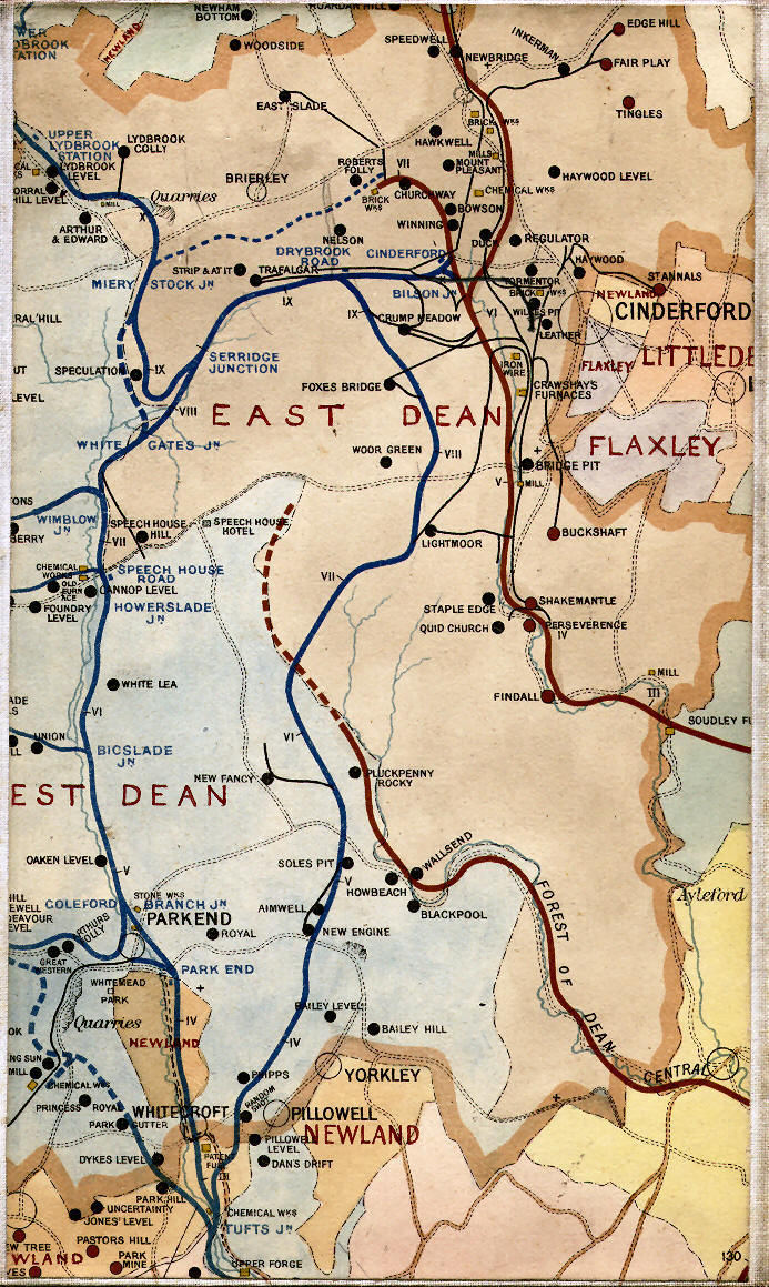
Bream-Flour-Mill-03

History

Sixteen years after the construction of the Oakwood tramway by David Mushet, in August 1843 William Jones applied to the Crown for permission to mine at the site now occupied by the Flour Mill, but soon sold his interest to George Skipp, who opened a wood distillery or chemical works, thought to have made “pyroligneous acid”, lead acetate, wood-tar and wood-pitch. This was sold in 1854 to Isaiah Trotter of Coleford, a well known Forest businessman, who ran the business at least until 1887. After several more owners it eventually closed in 1900.

Meanwhile Ralph and Arthur Price leased two acres nearby from the Crown for 31 years at a rent of £5 p.a. and began to sink a shaft in 1866, which was presumably completed by 1870, if not before, as they then applied for a connection to the Oakwood tramway, which ran past the site. The Flour Mill Colliery Company Ltd was formed in December 1873, but was in liquidation by January 1875, probably due to water problems, although ‘good coal’ was sold in 1874 at the colliery for 17s (85p) per ton.

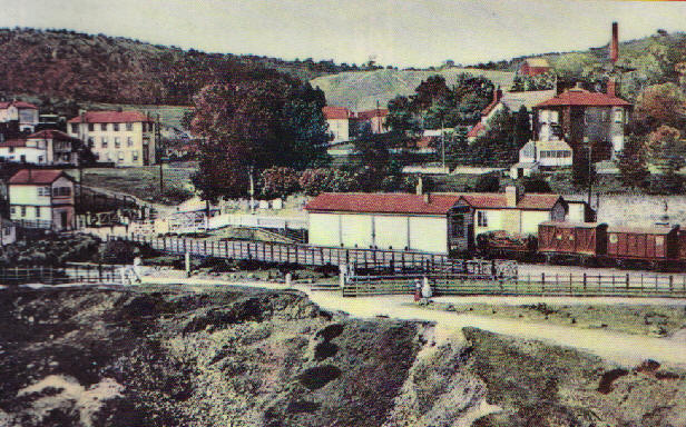
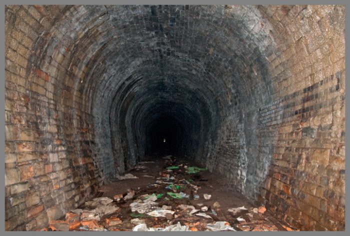
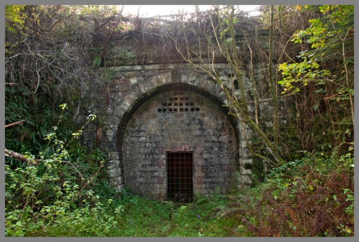
Evidently mining was carried on, because by November 1886 the colliery was owned by William Camm and Richard Watkins, who owned the nearby Princess Royal (also known as Park Gutter) colliery, which also had water problems. In 1892 a rope-hauled tramway was built to take Flour Mill coal for cleaning and sorting by new screens at Princess Royal, necessitating the construction of a broad bridge or ‘tunnel’ over the Oakwood Tramway.

Another shaft, 140 yards deep and 14’ in diameter, was sunk in 1904, but proved to be very wet. The new shaft necessitated another cut and cover bridge/tunnel to be built over the Oakwood tramway, to the north of the first tunnel, to enable trams of coal to be pulled to Princess Royal.

Flour Mill colliery was taken over by the Princess Royal Colliery Company in 1906.

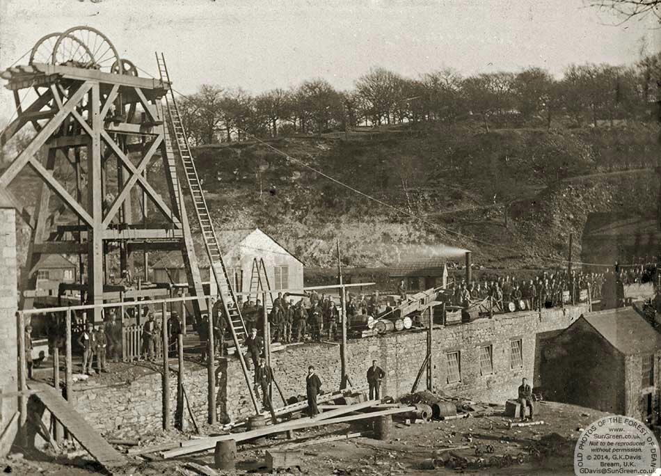
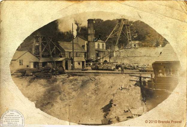
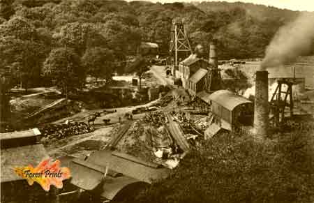
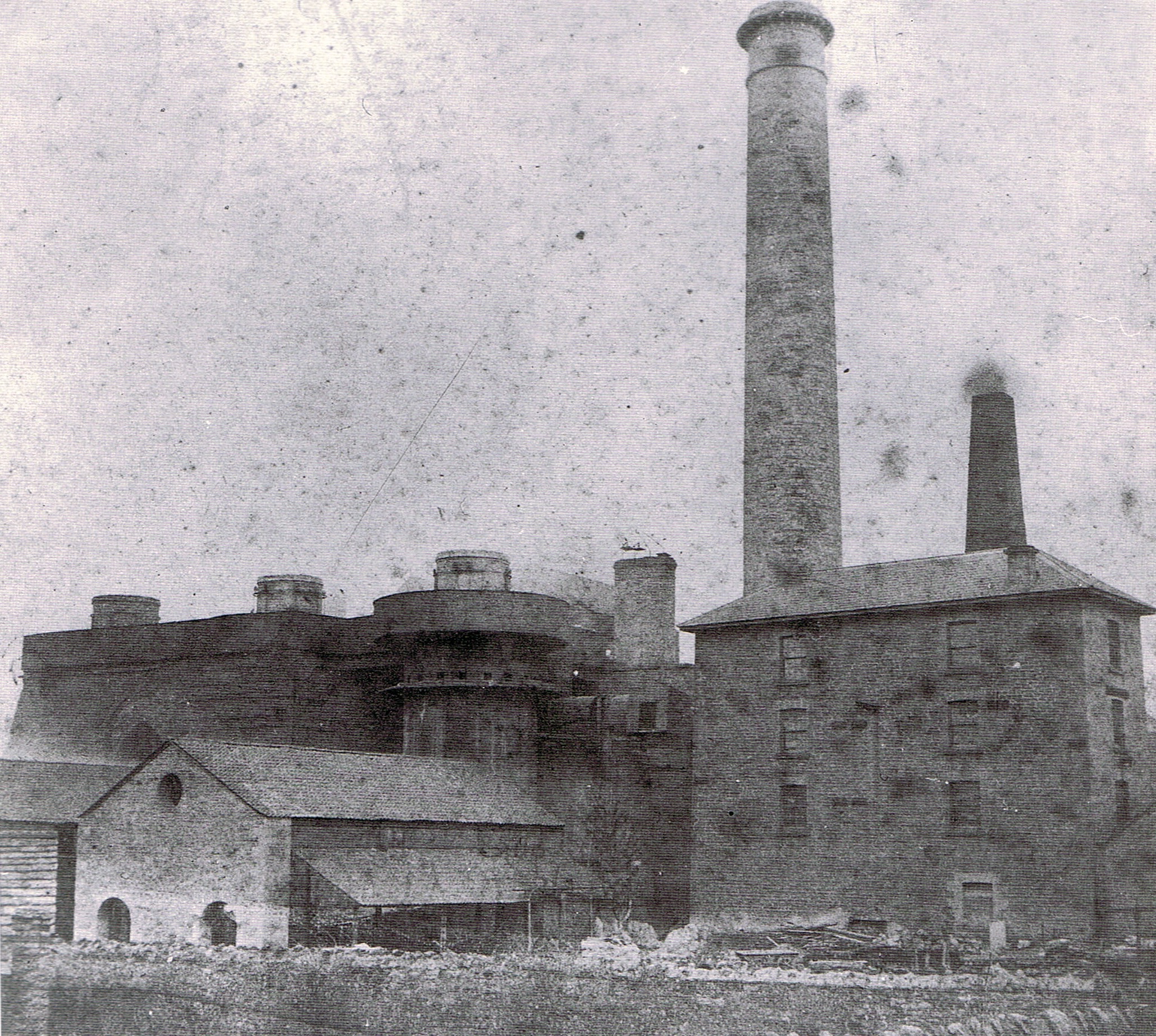
As a result of the water flowing into the mine, massive pumping was required, and in 1908 construction of a new building at the Flour Mill commenced, 100’ long, 40’ wide and 25’ high to the eaves. This housed two sets of Bellis & Morcom triple-expansion “high speed electrical engines”, one reportedly of 750kw running at 250 rpm and one of 350kw running at 333 rpm, powered by four Lancashire boilers in another building adjoining, now gone. It is probable that the building was doubled in length during construction, as some window details differ in the second four bays from the first four. Completed in 1909, this is the building that now houses the locomotive repair operations of The Flour Mill Ltd. The building has bolted iron roof trusses with diagonal bracing.

The use of electrical power at this date was still something of a novelty. Trafalgar Colliery, also in the Forest of Dean, was the first colliery in the world to use electrical power underground for motive power, in 1882, while the City of Gloucester only received its first general supply, on a very limited scale in 1900.

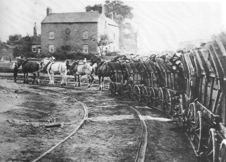
The two collieries, Flour Mill and Princess Royal, were connected underground in 1916 to improve ventilation and safety, and to permit larger-scale production. However the stables for the pit ponies remained at the Flour Mill – the cages were so small that the ponies had to sit on their haunches going down or up the shaft! The Flour Mill colliery had a long and interesting life: there was a strike in 1909, when the pit ponies were sold, and then the bitter national strike of 1912. Several men were killed in the pit, one during the sinking of the first shaft. The main shaft was used as an emergency second way out, but after the war the pit was connected to the National Grid and the power station no longer needed.

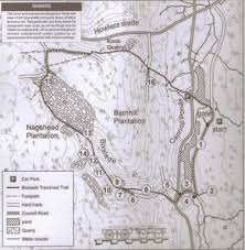
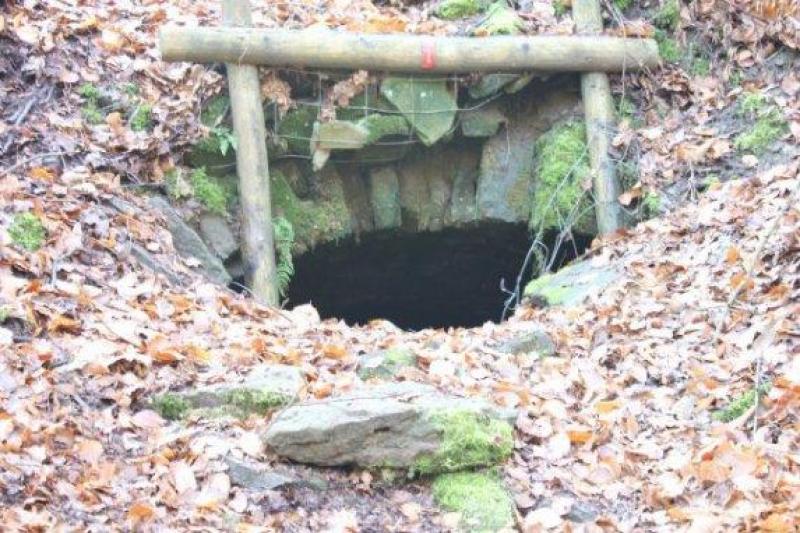
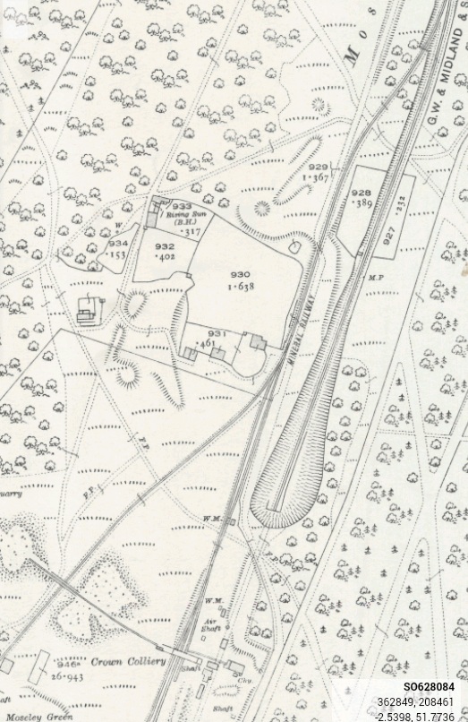
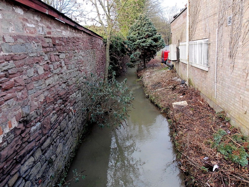
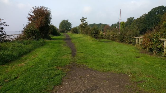
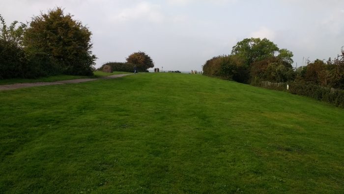
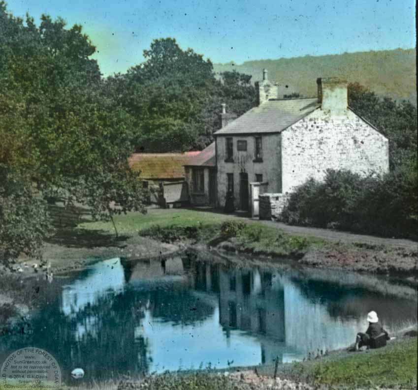
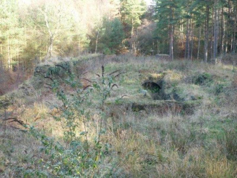
The whole area around the Colliery holds a wealth of interesting material. North of the colliery buildings, the colliery spoil heap is relatively small. It sits alongside the old tramroad route (SMR 15249), with some fine stonework in the form of sidings and 2 tunnels in basically sound condition. This tramroad continues north running alongside a stream which then forms a pond. This area is a Gloucestershire Wildlife Trust botanical site. The tramroad doubles as a path and continues north. The mine shaft has been capped, while a depression near the buildings suggests a second filled shaft.

A rope-worked tramway was laid in 1891 from Flourmill Colliery to Princess Royal Colliery (Park Gutter) (SMR 5844), enabling coal to be brought to the new screens there and link with the Severn and Wye Railway.

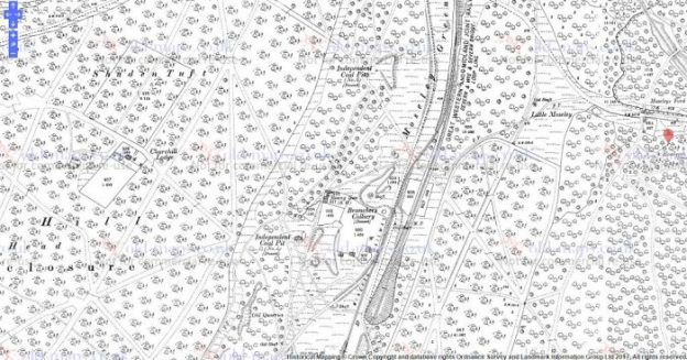
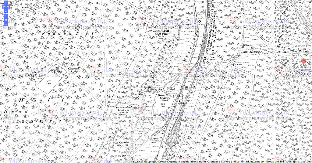
The colliery was connected underground to the Princess Royal Colliery (aka Park Gutter)and also through that colliery to Norchard Colliery nr Lydney and New Norchard Colliery at Pillowell.Flour Mill had 3 shafts and in later years was only used for ventilation and maintenance of Princess Royal Colliery. Most of this whole complex of collieries was closed in 1961/62 although some coal from the New Norchard Colliery was still processed at the Princess Royal site up until 1965. The 2 ‘small’ shafts at Flour Mill were filled around that time (1965/66) but the impressive main shaft was capped and left forgotten until 2007. It was finally filled and recapped by the close of 2008.

References

1. http://www.theflourmill.com

2. Gloucester County Council Historic Environment Report Monument No. 5826.

3. http://www.SunGreen.co.uk

4. http://www.forestprints.co.uk

5. http://lightmoor.co.uk/forestcoal/CoalFlourMill.html

Parkend, Forest of Dean

Parkend had quite a concentration of tramways associated with local collieries and iron works as well as hosting the terminus of the Oakwood Tramway at Marsh Sidings. The extract from the 1880s OS Map shows them clearly.

image_crop__2017_09_29_15_53_53_068

Prior to the construction of the Severn and Wye railway, the Oakwood Tramway connected directly to the Severn and Wye Tramway just to the south of the location of Parkend Station. Parkend dates back to the early 17th century. During the 19th century it was a busy industrial village with several coalmines, an ironworks, stoneworks, timber-yard and a tinplate works, but by the early 20th century most had succumbed to a loss of markets and the general industrial decline. Wikipedia records the history of Parkend as follows:

In 1278 the first record of a hunting enclosure called ‘Wistemede’ – later known as Whitemead Park has been found. The village’s location, at one end of this park, is how Parkend derived its name. In 1612 James I built a charcoal-fired blast furnace and forge at ‘Parke End’, bringing with it the first real settlement, however, ‘The King’s Ironworks’ proved horrendously inefficient and it closed in 1674. It would seem that occupation of the village then ceased until new dwellings appeared from 1747 onwards.

Part of the Fountain Inn dates back to 1767 and is the oldest surviving building in Parkend. The first record of a coal mine in Parkend dates back to 1718, although the remains of several bell pits, possibly dating back to the 1600s, are visible in the woods south-west of St Paul’s church.

With the advent of coke-fired furnaces, Parkend, and its many coal mines, was once again considered an ideal location for the production of iron. In 1799 a new ironworks was constructed near the site of the current post office. Initially it suffered from technical problems, but by the early/mid-1800s it had triggered a major industrialisation of the village.

The need for improved transport links was instrumental in the construction of a horse-drawn tramroad by the Severn & Wye Railway Co in 1810, connecting the village with the docks at Lydney. Demand for coal at the ironworks also lead to the appearance of several large coal mines in the village during the early 1800s, the most notable being ‘Castlemain’.

In 1818/9 another ironworks was also built at Darkhill, just to the west of Parkend, and in 1845 Robert Forester Mushet took over management of the site. One of his greatest achievements was to perfect the Bessemer Process by discovering the solution to early quality problems which beset the process. In a second key advance in metallurgy Mushet invented ‘R Mushet’s Special Steel'(R.M.S.) in 1868. It was both the first true tool steel and the first air-hardening steel. It revolutionised the design of machine tools and the progress of industrial metalworking, and was the forerunner of High speed steel. The remains of Darkhill are now preserved as an Industrial Archaeological Site of International Importance and are open to the public.

In 1825, the lower pond at Cannop and a 1½ mile leat were constructed to provide a constant supply of water to a waterwheel at Parkend Ironworks. Despite the enormous effort expended in creating this supply, it proved inadequate and an engine house and steam engine were added in 1828. A second pond at Cannop was also constructed a year later.
The school and St Paul’s church were built in 1822 and Henry Poole, who had designed both, became Parkend’s first vicar. He moved into the new vicarage in 1829, but the school developed structural problems and was rebuilt, on the same site, in 1845.

A stone works opened in 1850 and a tinplate works was constructed in 1853. It stood to the left of the ironworks, and further along was built a row of terraced houses, known as ‘The Square’, which were used to accommodate the workers there.

In 1864 the Severn and Wye Railway Company began operating steam locomotives on the existing tramway. This proved to be unsatisfactory and 1868 the company also added a broad-gauge steam railway line, but both were removed and replaced with standard gauge tracks by 1874. At around the same time, a loading wharf, known as Marsh Sidings, was constructed and Parkend railway station opened in 1875, allowing the company to also operate passenger trains alongside its freight operations.

Parkend Ironworks

In 1871 a third furnace was added at Parkend Ironworks, but the optimism behind this investment was to be short-lived. During the mid-1870s, industry in the Forest, and across the country as a whole, quickly began to slide into a deep recession. Parkend Tinplate Works, and the ironworks that had dominated the village for 90 years, succumbed to a loss of markets and both closed in 1877. Just a few years before, these two businesses alone had been employing 500 people between them, but even this was overshadowed by the closure of the Parkend coal pits in 1880, which went into voluntary liquidation with the loss of 700 jobs.

By the mid-1880s, the industrial decline that had gripped the Forest was beginning to ease. The mines, which had closed in 1880, reopened in 1885 and by the 1890s they were prospering once again. The ironworks did not re-open and were demolished by 1909, although the imposing engine-house survived to become the country’s first Forester Training School in 1910.

photos from St Marys Sept 05 012

The 1920s proved to be another difficult period for the residents of Parkend. The high demand for coal, that had been created by the First World War, was followed by a slump and industrial unrest. Matters were made worse as the local mines were now finding it difficult to access coal easily, and some had been worked out completely. There were major strikes in 1921 and 1926, and all the village mines, except New Fancy, finally closed for the last time in 1929. There was a considerable knock-on effect for other industries too and the railway closed to passengers in the same year. Parkend stone works closed in 1932, marking the end of heavy industry in the village.

post-1103-0-60828900-1397488354

References

1. https://en.m.wikipedia.org/wiki/Parkend
2. https://en.m.wikipedia.org/wiki/Parkend_Ironworks

Notes on The Branch Tramways and Sidings of the Severn and Wye Tramroad.

The featured image shows stone being transported down the Bixslade Tramway, one of the feeder tramways to the Severn and Wye Tramroad.

There were at least 12 branch tramroads off the Severn and Wye Tramroad. Many of these remained as feeder routes to the Severn and Wye Joint Railway in the 19th Century.

The branch tramroads included the Mirystock-Lydbrook-Bishopswood tramroad and the privately owned Oakwood and Dyke’s tramroad branches. In addition scores of sidings and short branches served particular mines, quarries and works. Traces of most of the branches remain. I intend over time to look at all these tramroads. The notes are merely an introduction and are picked up from the references below.

With the exception of the Churchway branch (and possibly Moseley Green), locomotives did not serve the branch lines – they were too steep and relied on very tight curves. Various proposals for converting the branches to railways met with little success and they were gradually superseded or abandoned. Three branches however, Bixslade, Howlers Slade and Wimberry Slade, remained in use into the 20th century.

Prior to the construction of the harbour at Lydney, a tramroad ran down to Lydney Pill. Once the outer harbour was completed in 1821, the tramroad was extended along the north side of the canal and a branch which ran across to a new wharf on the west side of the harbour was added in 1823.

Details of some of these branch lines and sidings are included here:

There was a short branch to the Lower Forge, connection to a private tramroad was made in 1818.

In 1814, connections were made to Upper and Middle Forges.

Kidnall’s Mill (or Moseley Green) Branch is covered in a separate article entitled ‘Moseley Green Tramways’ (https://rogerfarnworth.wordpress.com/2017/09/27/moseley-green-tramways)

Birches Branch is also partially covered in the above post. It left the main line south of Parkend and passed through Oakenhill Inclosure to Birches Well, Independent, and other coal pits.  By about 1849 the branch was disused. The Birches branch can be traced where it crosses the Parkend-Yorkley road as a broad path and can also be picked up on Moseley Green behind the Rising Sun Inn, and where it crossed the Parkend-Blakeney road.

The map in my article (https://rogerfarnworth.wordpress.com/2017/09/27/moseley-green-tramways) shows the approximate position of these locations.

Milkwall or Darkhill Branch brought iron ore from the Milkwall area to Parkend, served collieries and wandered through large quarries. It was under construction in 1812 and followed a torturous hillside route. Some of the worst curves on the branch were being smoothed out in 1860. The tramroad was in operation until the railway was built. When the Coleford Railway replaced the tramroad branch, a section from Milkwall to Sling was left in place with a transhipment wharf at Milkwall, conversion of this section began in 1875.

The tramway route can be found on the 1881 Ordnance Survey … (http://maps.nls.uk/view/109726222) and the 1905 Ordnance Survey …(http://maps.nls.uk/geo/explore/#zoom=17&lat=51.7805&lon=-2.6026&layers=168

Ivy Moorhead Branch was built by 1813. The line had been taken up and re-aligned by the Park End Coal Co. in 1821 to carrying coal to the ironworks. However, the branch became part of the Severn and Wye tramroad again in 1829. The furnaces of the Parkend Ironworks were served directly by a branch that ran over the main tramroad via a “covered way”. In 1877 the line still served the Royal pit (then Castlehill Colliery), but it had been removed by 1901.

Brookhall Ditches Branch seems to have served for a short time in the second decade of the 19th century before being abandoned. In 1824 a request was made to replace the rails as the abandoned Brookhall Ditches works were re-opened by the Park End Coal Co. A licence was obtained in 1837 for an extension to Foxes Bridge, however the Kidnall’s Mill branch, opened in 1841, offered a more direct outlet, avoiding the busy Parkend area. However, the Foxes Bridge Pit in question never opened. The Brookhall Ditches branch wasnwas abandoned once again in the mid 1870s.

Bixslade Branch

The above image shows this branch and the next two below, it is taken from the English Heritage, Forest of Dean Mapping Project, Gloucestershire: A report for the National Mapping Programme.[3]

The Bixslade branch was completed in 1812 and left the main line on an embankment and ran across a dam  made by the Forest of Dean Iron Co. in 1825 to create the Cannop Ponds. By 1841 the branch served 3 collieries in addition to the Bixhead quarries. Several licences were granted in the 1890s for extensions around the Bixhead quarries. The line was still in regular use in 1946 by a coal pit near Bixhead, although the last load of stone was brought down the line in 1944.

The branch was owned and maintained by the Severn and Wye Co. to just short of the quarries. The lines within the quarries were provided by the traders although often the S&W provided the tramplates.

The line was extended for short distances from time to time as the quarries developed, the Severn and Wye generally supplying the plates and the owners doing the rest.

There is a very enjoyable short walk or noted by the Forest of Dean Local History Society, as shown on the map here.

Howler’s Slade Branch ran parallel to but above the Speech House to Coleford road for most of its 1 mile course and was begun in 1811. In addition to various pits and quarries, the branch also served a chemical works at Cannop Bridge and a foundry. Although derelict by around 1920, the track was not removed until 1941. From its crossing of the B4226, its course can be traced, crossing Cannop brook by a bridge with cast iron railings, past the remains of the chemical works and then over the B4234 Cannop-Lydbrook road immediately to the North

Much of the tramway route is over level ground but embankmentss andaand cuttings were employed in places.

Wimberry Slade Branch – originally terminated near Wimberry Colliery, but the line was later extended to serve other pits, and was completed at the same time as the main line. A broad-gauge railway branch was laid over the first half-mile as far as Wimberry Colliery in 1868, however the tramroad branch continued in use. Abandonment was authorised in 1874, however the western section continued in use, terminating on a wharf at Hopewell sidings. A succession of alterations were made to the tramroad over the years – with new sidings being laid as late as 1928. Part of the line was in occasional use in 1939, however in 1940, 14 chains were taken up for repairing the Bixslade branch. In 1943 the remaining 38 chains were damaged by military traffic along the line which was removed entirely in 1946. Traces of the tramway can be followed from where the railway bridge crosses the B4234.

SMDB-Image-089

The Wimberrry Slade branch is marked on the tithe map and the 1st-3rd County Series OS maps. The western section of the route can be traced on aerial photographs. The tramroad extends for 520m in an east/west direction along a dry valley and continues to the east a little further. The western end terminates at Wimberry quarry.

Churchway Branch – the tramroad at Churchway was authorised in 1810, however no connection was made to the Forest of Dean Tramroad and in 1814 rails were taken up. Eventually in 1823 a licence for a connection was eventually given. At Mirystock the Churchway branch curved from the main line and in 1847 a new curve was put in making a triangular junction. In 1865 following the opening out of the Mirystock tunnel into a cutting a new line was laid improving the access to the Churchway branch. Abandonment of the tramroad branch was authorised in 1877 and the tracks taken up almost immediately.

The Severn and Wye Co built a branch from Mirystock to Churchway, where a junction was made with the Bullo Pill tramroad in 1812. A short loop line at Mirystock was constructed in 1847 to give better access to the Churchway branch from the south, a second spur to the Churchway branch was constructed in 1865.

Lydbrook Incline is heavily overgrown. The steep descent to the Wye at Lydbrook was an inclined plane controlled by ropes, which was abandoned by 1856.

Bishopswood Branch –  completed in 1814, was linked by an inclined plane to the forge on Lodgegrove Brook. The branch ran as far as the Ross road in 1833. It carried little traffic and the track was taken up in 1874.

This was an extension from the original terminus at Lower Lydbrook, taking the line onwards to the Wye at Bishopswood. It was opened to serve the Bishopswood Ironworks. From the site of Lower Lydbrook station it curved towards Vention Lane, which it crossed below the Royal Spring Inn, and then on to the B4228 near the turning to Ruardean. Apparently, until the early 1950s, the route from Ventions Lane was used byuby horse drawn cartstcarts to supply Incline Cottages with coal.

References

1. English Heritage’s Monument Protection Programme (MPP) Step 3 report.

2. Gloucestershire County Council Historic Record Archive which holds a great deal of source information. Monument No. 5701.

3. Fiona Small & Cathy Stoertz; The Forest of Dean Mapping Project, Gloucestershire: A report for the National Mapping Programme; English Heritage, National Monuments Record Centre, Great Western Village, Kemble Drive, Swindon, 2006.


Moseley Green Tramways

The featured image above is not from the Forest of Dean but is typical of the tramways/tramroads of the area. It is actually a picture of the Little Eaton Tramway in the Midlands.

img50Moseley Green Tramroads

A map of railways in the Eastern half of the Forest of Dean in 1894 clearly shows a short stub end of tramroad at Moseley Green associated with three pits, Soles, Aimwell and New Engine. The Historic Environment Record Archive says that: “A number of earthworks associated with the Moseley Green branch line are visible on aerial photographs. After leaving the mineral loop the branch heads south running parallel with the main line before being taken south west by an embankment at SO 6320 0852. The embankment is approximately 80 metres long and ends at SO 6310 0844 at a cutting. The cutting can be traced for approximately 95 metres terminating at SO 6301 0834 near the Moseley Green New Engine Coal Pit.” All of this is visible in detail on the OS map below.


Earlier in the same document it is noted that: “A number of earthworks associated with the Birches branch line are visible on aerial photographs. A cutting at SO 6176 0736 is close to where the line begins; it takes the line westwards into Oakenhill Inclosure. A second cutting starts at SO 6184 0783 and can be traced for 218 metres. On leaving the cutting the line heads north west and then follows a series of loops where after a cutting 35 metres long it returned to its north west course to Moseley Green. On entering Moseley Green the line is taken to the western edge by a cutting with a flanking bank and heads north passing through a second cutting with flanking bank and on to a junction at SO 6332 0919. Northwards from this junction the line passes the spoil heaps of the most northerly colliery on Moseley Green and through a cutting before turning west on an embankment to New Fancy Colliery. Southwards, the line passes through a cutting and connects with the Moseley Green Branch Line.”
On the map below, the blue line appears to be the route of the Birches/Moseley Green Tramroad. We walked a good length of that route on 27th September 2017. The pink route is the Moseley Green branch referred to in the notes above. We also walked along the turquoise route on 27th September which has earthworks associated with tramroad. It runs parallel to and to the west of the Mineral Loop Line.

IMG_20170927_150925369

That route is the line of the Kidnall’s Mill/Moseley Green Tramroad which was superseded by the Mineral Loop. The construction of the tramroad did not commence until 1841 and was not completed until 1844. The tramroad ran north from the approximate location of Tufts Junction on the Severn and Wye Joint Line, north through Phipps Bottom and then just to the west of the later Mineral Loop Line.

A licence of 1843 authorised an extension to Foxes Bridge, but this was not completed, Foxes Bridge was unopened. A new line with easier curves was completed in 1856 from Pillowell to Tufts, however the superseded route from Whitecroft was repaired in 1866, as it was more direct for the Patent Fuel Co. there. A branch to New Fancy Colliery (SMR 5824) was made by the Park End Coal Co. in 1859. The Kidnall’s Mill branch was superseded by the Mineral Loop Line and it was abandoned in 1874.

The Kidnall’s Mill branch passed under the Parkend to Yorkley road by a short tunnel just west of the railway tunnel, the keystone on the south side is marked 1842.

Beyond, the route is covered by a colliery tip, a railway siding and then the roadway, to the junction with the Birches branch. Here the line forks to serve New Fancy (SMR 5701/16), the line to which was laid in 1859 and Wellington Colliery (this part of the line has been obliterated by the railway embankment).

References

1. Gloucestershire County Council: Historic Environment Record Archive…. Monument No. 5701.


Lydney Harbour

The featured image comes from the booklet prepared for the 90th birthday celebration of Charles Bathurst 1st Viscount Bledisloe of Lydney in 1957. Copyright for the image, and for some others in this blog, is held by G.K. Davis of Bream in Gloucestershire (www.sungreen.co.uk). Details of the career of Lord Bledisloe can be found at …

https://en.m.wikipedia.org/wiki/Charles_Bathurst,_1st_Viscount_Bledisloe

The image shows the extensive nature of the railway infrastructure at the Harbour. All of this has now gone!

Lydney Harbour and its Transport Links

From Roman times through the industrial revolution and well into the 20th century Lydney Harbour has had a significant place in the heritage of the River Severn and its estuary.
The estuary has a massive 48ft tidal range, is an internationally important wildlife habitat and has had a major impact on the prosperity of Great Britain as one of the UK’s principle sea links to the rest of the world.

Lydney Harbour was a prominent local harbour for coal, iron ore and other commodities and integral to the economy of the South West over centuries.

Easy access to the estuary resulted in Lydney’s importance as a trading centre and a harbour was built to transport iron and later coal from the forest. The harbour was originally the last port on the Severn where sea-going boats could unload. Where the River Lyd flows into the estuary was known as Lydney Pill. However, the silting up of the local river closed the old harbour and a new wharf had to be built. With the charcoal iron industry and coal production thriving and roads through the forest remaining poor, Pidcock’s canal was constructed from 1790 onwards, connecting Upper and Lower Forge at the head of Lydney Pill.

The current canal and basin complex was built by the Severn and Wye Railway and Canal Company between 1810 and 1813. A horse drawn tramway was laid, to move the coal and iron to the wharves after it was brought down from the pits and forges on the Pidcock’s Canal. The new dock on the estuary was started in 1809 and opened in 1813. The outer harbour was finally completed in 1821.


During the hey-day of the harbour there was around 300,000 tons of coal being exported annually in over 2000 vessels. The final export of coal from the harbour was in 1960.

image_crop__2017_09_26_20_15_11_175In the 1960s imported wood was still being brought in by barge from Avonmouth. It remained in commercial use until the 1970s. The entrance to the canal consists of an outer tidal gate opening into a wide basin. From there a lock opens into the one-mile canal cut. Immediately above the lock, a pair of gates point the other way as protection against a high tidal flood in the estuary. There is one swing bridge crossing the canal.

In 1985 the harbour from the swing bridge downstream was scheduled as an ‘Ancient Monument’, due to the historic importance as a transport link for the Forest of Dean to the Severn. The swing bridge was designated a Grade II Listed Building in 1988 due to it being ‘a very good example of the direct and sturdy quality encountered in the functional tradition of quay-side design’.

As the last major alterations to the harbour were conducted during the 1870s, Lydney is a rare example of an unspoilt 19th century harbour, built to accommodate sailing ships so its historic importance is disproportionate to its size.
In 1998 the Lydney Docks Partnership was established to create a sustainable future for the Harbour. In 2003 they secured from the Heritage Lottery Fund £873,000 towards restoring the docks. This was supplemented by further funding from the Environment Agency, English Heritage, Gloucestershire County Council, Forest of Dean District Council and Lydney Town Council.

As part of the reconstruction process archaeologists recorded evidence of the docks’ historic use. The results of this work have provided an important insight into how the harbour functioned in the Nineteenth century.

The archaeological work has helped define the historic value of the surviving standing buildings on the site. Additional landscaping works have taken place to improve disabled access and address public safety issues.

On the 23 July 2005, Lydney Harbour was re-opended after a two year restoration project. Restoration included:

Restoring and enhancing flood defences running along the side of the dock.
The installation of four custom-made automated metal-gates and associated mechanisms, in the outer dock and inner harbour. These replaced the older, dilapidated hand-operated timber gates.
Dredging of the dock and harbour to remove several tonnes of silt (and the odd wrecked car) which had accumulated over the years.
Full refurbishment of dressed stonework on the walls and the floors of the docks.
Improving access for all.
Additional landscape works.

Timeline
1809 – The Lydney and Lydbrook Railway Act enabled construction of a tramroad from Lydbrook to Lydney.
1810 – A second act changed the company name to the “Severn & Wye Railway and Canal Company” and (amongst other things) authorises the building of the canal to the River Severn at Nass Point.
1810 – Josias Jessop (son of William Jessop) was appointed consulting engineer and designed plans for the canal.
1811 – Thomas Sheasby (son of Thomas Sheasby senior) was taken on as resident engineer.
1813 – The canal was opened by the Severn and Wye Railway and Canal Company.
1821 – The outer harbour was finally completed and the tramway extended all the way down.
1825 – The north pier was extended to aid ships into the harbour.
1868 – The tramway was converted to broad gauge.
1872 – Converted to standard gauge.
1893 – Severn and Wye Railway and Canal Company went bankrupt.
1894 – Purchased by the Great Western and Midland Railways and administered by a Joint Committee of the two companies.
1948 – The railway and docks passed to the Western Region of the Railway Executive on nationalization.
1950 – Transferred to the Docks and Inland Waterways Executive.
1960 – The last coal was shipped from the harbour.
1977 – The harbour was closed.
1985 – The section from the swing bridge to the Severn was scheduled as an Ancient Monument
1988 – The swing bridge was scheduled as a Grade II listed building.
1996 – The Environment Agency took over management of the docks.
1997 – Inner gates collapses and had to be replaced by a dam to reduce flood risk.
1998 – The Lydney Docks Partnership was established to create a sustainable future for the canal.
2005 – Re-opened after a two-year project of restoration and enhancement.

Pidcock’s Canal

The Cut Lydney - geograph.co.uk - 3834849
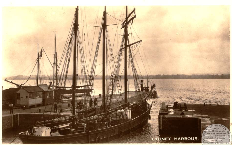
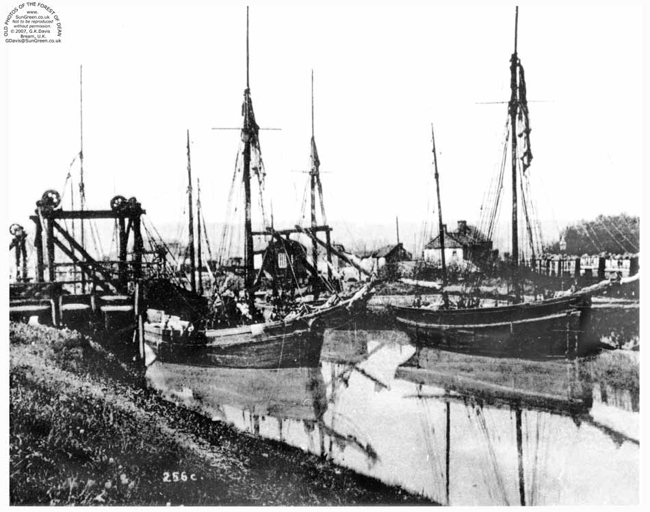
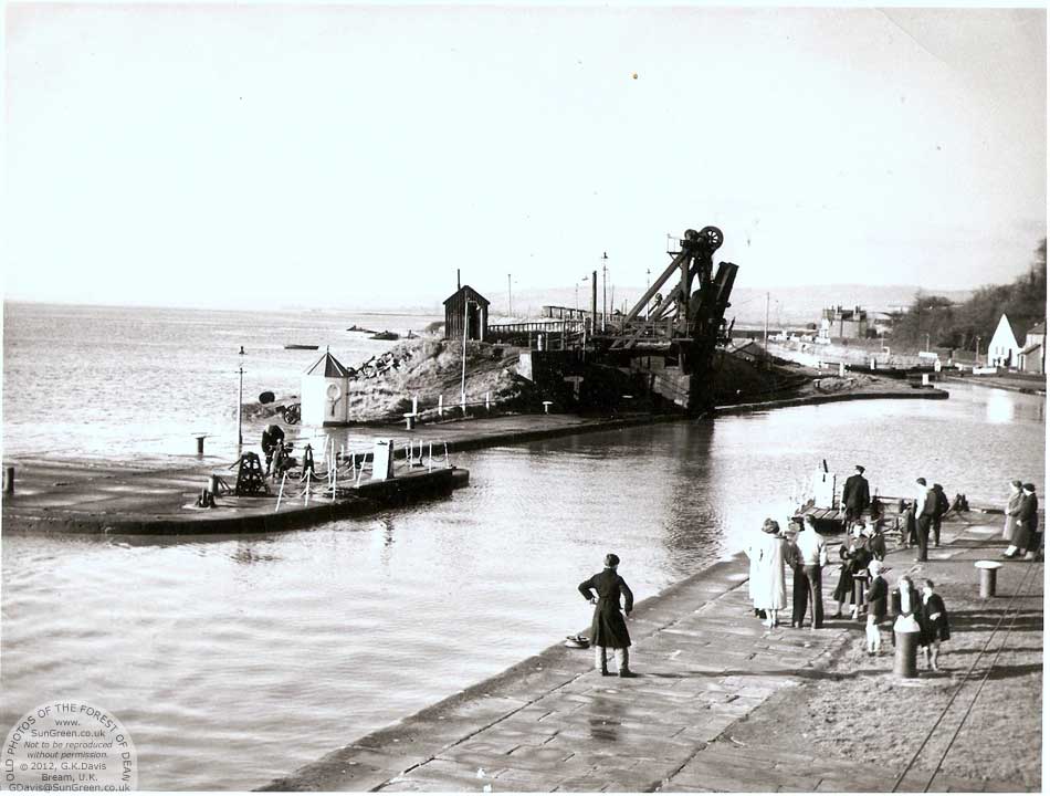
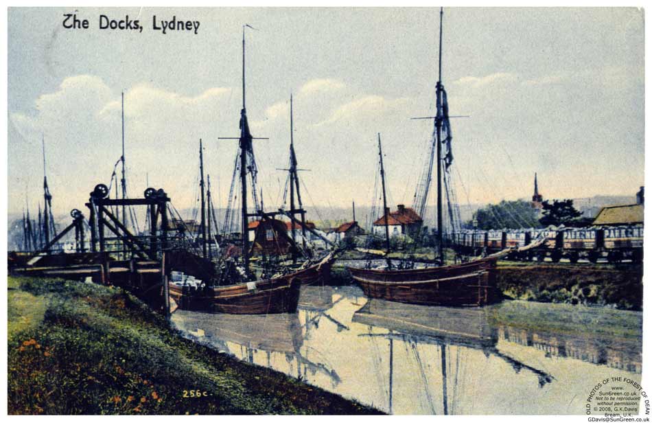
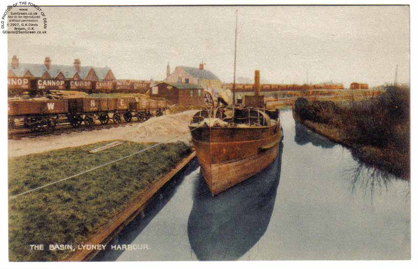
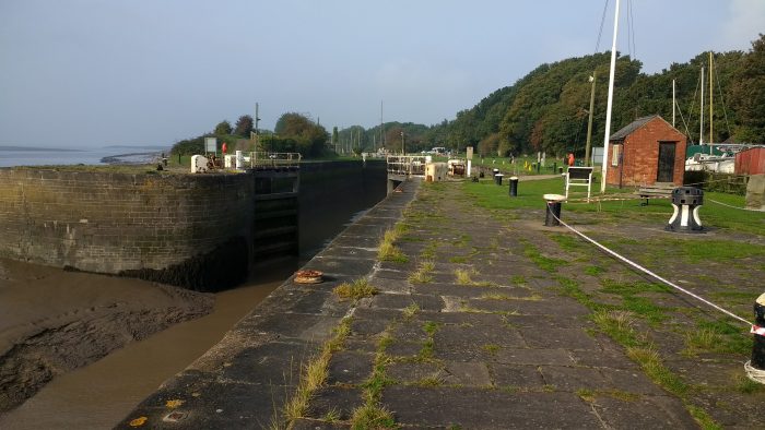
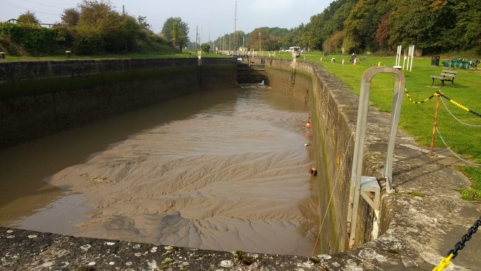
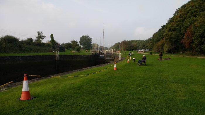
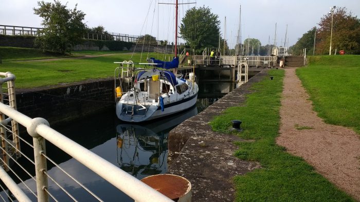
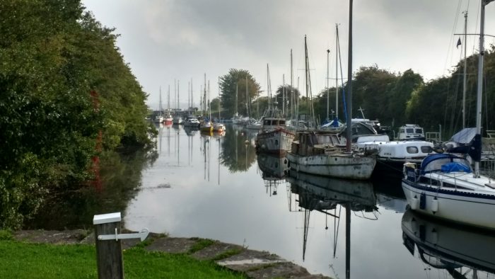
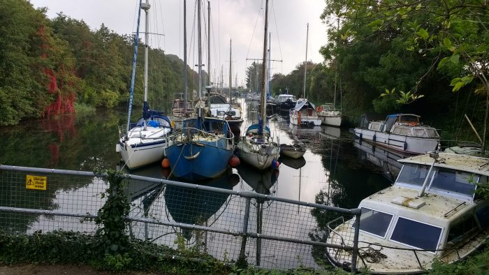
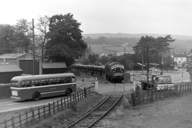
Pidcock’s Canal was a canal in Gloucestershire, England, which connected ironworks at Upper Forge and Lower Forge, and also ran to an inlet from the River Severn called Lydney Pill. It was constructed from 1778 onwards[4], and there were three locks below Middle Forge. Following the construction of the Lydney Canal in 1813, the canal connected to that, rather than Lydney Pill, and it was disused after 1840, by which time a horse-drawn tramway had been built up the valley of The Lyd. The tramway was eventually relaid as a steam railway and is now preserved as the Dean Forest Railway. Most of the canal, colloquially called The Cut, still exists below Middle Forge.

Large parts of the parish of Lydney were organised as an estate, which had been managed by the Bathurst family since 1723. The estate contained mineral reserves, and they profited from this by building ironworks. The Lower Forge ironworks were supplied with water by several streams, which were augmented by a long leat which left the Newerne stream near the Chepstow road.[5]

In 1775, David Tanner from Tintern was granted a lease of the Upper Forge, on the northern borders of Lydney. A new 99-year lease was negotiated in 1778, which included powers to construct a canal from there to the Lower Forge. It is known that the canal had been built by 1790, although the precise date of construction is unknown. Tanner sold his lease in 1789, and in 1790 it was sold again to members of the Pidcock family, who were glassmasters from Staffordshire. The Pidcocks managed the forges until 1813, when the lease was sold back to the Bathursts. They also had coal mining rights, and transported coal to Lydney Pill using the canal. On surrender, the lease covered the Upper and Middle Forges, the Lower Forge and rolling mill, the White Cross furnace, and the canal, which had by then been extended to Lydney Pill. John James took on the lease from 1814, building another forge at New Mills in the 1820s, and using the Lower Forge as a tinplate works from 1844. In 1889, Richard Thomas, who had leased the works from 1876, made improvements to the Lower Forge tinplate works, and the remaining works were stripped and abandoned.[5]

The Lydney and Lydbrook Railway (tramway) was authorised by an Act of Parliament in 1809. This became the Severn and Wye Railway and Canal in 1810 and construction of a tramway and canal to Lydney Harbour commenced in the same year. The tramway ran parallel to Pidcock’s canal as it followed the course of the Newerne Valley.[5] Pidcock’s Canal fell into disuse in the 1840s.[6]

The canal started at the Upper Forge, and ran close to the Newerne stream, also called The Lyd. The lower section took a more direct route to the Lower Forge, using the course of the leat which had supplied the works with water.[5] There were three locks near the Middle works.[7] The canal crossed the Chepstow road between Lydney and Newerne, and the branch from the Lower Forge to Lydney Pill was quite short.[5]

In 1880, the Upper Forge, New Mills and Middle Forge all had extensive ponds upstream of the works, contained by stone dams. Once the canal closed, the ponds covered its route between Upper Forge and Middle Forge. Ordnance Survey maps for the period show weirs and sluices at the downstream ends of the ponds, and the central one at Middle Forge appears to feed the canal. By 1880 there was no obvious route around the dams, and there is no mention of locks to allow boats to move between levels. As on modern maps, the canal was known as The Cut at the time. From the Lower Mill, the canal formerly ran to Lydney Pill, but the waterways were altered as a result of the construction of the Lydney Canal. The 1880 map shows two channels below the Lower Mill, one clearly joining the bottom of The Lyd, before it discharges into the Lydney Canal, and the other running from the reservoir on the upstream side of the works to a wide basin near the Lydney Canal, but with no obvious connection between them. Halfway along this section is a small branch which ends just south of Station Road Cottages.[5][8]

Tramways and Railways

Lydney map 1946
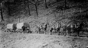
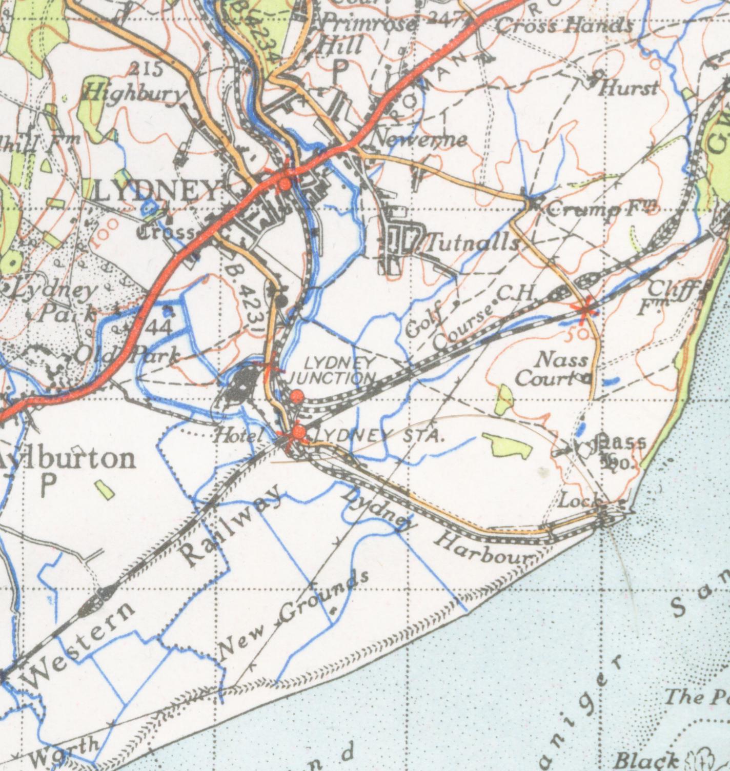
In the late 18th and early 19th centuries, a network of horse-drawn tramroads developed in the Forest of Dean, to transport coal and ironstone to the local ironworks, and, following the development of docks on the Severn at Bullo Pill and Lydney, to ship coal and other Forest products to markets further afield. With the introduction of railways to the Forest, beginning in the mid-nineteenth century, the tramroads were progressively superseded, in places physically overlaid, by the new transport system, though some continued as feeders to the railways well into the 20th Century. Many traces of the old tramroads remain, sometimes as footpaths following a trackbed, or as remains: stone sleeper blocks, earthworks, bridges and other structures.[9]

The Severn and Wye Tramroad, engineered by Roger Hopkins for the Severn and Wye Railway Co. opened in 1810. It ran from Lydney to Bishopswood with several branch lines linking it to collieries and ironworks. Various parts of the tramroad were absorbed into the Severn and Wye and Severn Bridge Railway from 1868 onwards. Also the Lydney and Lydbrook Railway, was incorporated in 1809 and completed 1812, it connected the Severn with the Wye, with many branches serving collieries, iron works, and other enterprises. Steam traction was introduced, in 1864. The original tramroad is not readily discernible except at points where it deviated from the railway which replaced it. The numerous branch lines are more easily traced and stone block sleepers are common.

Plans for a tramroad to link the mines of the west part of the Forest with the Severn at Lydney and the Wye at Lydbrook were under discussion from 1799, and an Act of 1809 authorised a line. A further act of 1810 renamed the project the Severn and Wye Railway and Canal and gave powers for a tramroad to a place just south of the head of the Lydney Pill and for a harbour in the form of a short canal. The line was built by a partnership including John Protheroe and bother local industrialists. It was completed in 1813 and followed the course of the Cannop Brook in the west part of the Forest and included a tunnel at Mirystock. Several branches were laid down by the tramroad companies but most were laid down by mine and quarry owners. The company provided early branch lines to serve mines and quarries in the slades west of Cannop Brook and built a line from the top of the Lydbrook incline down to the Wye at Bishopswood. Steam locomotives ran on the tramroad in 1864 and a broad gauge line was opened alongside the tramroad between Lydney and the bottom of Wimberry Slade in 1869 and in 1872 a standard gauge loop line was completed. Beginning in 1872 the Severn and Wye constructed a standard gauge railway from Lydney to Bilson and Lydbrook. When the railway was laid on or alongside the tramroad much of it was abandonned. A short section remained open fgor a time to serve Lydney tinplate works and a number of branches remained active well into the 20th Century.

There were 12 branch tramroads, including the Mirystock-Lydbrook-Bishopswood section and the privately owned Oakwood and Dyke’s branches. In addition scores of sidings and short branches served particular mines, quarries and works. Traces of most of the branches remain rarely being disturbed by the later railways. With the exception of the Churchway branch (and possibly Moseley Green), the tram locomotives did not serve the branch lines, being too steep and torturous. Various proposals for converting the branches to railways met with little success and they were gradually superseded by adjacent railway routes or abandoned. Three branches however, Bixslade, Howlers Slade and Wimberry Slade, remained in use into the 20th century.[10]

Prior to the construction of the harbour, the tramroad ran down to Lydney Pill by a temporary railroad. Once the outer harbour was completed in 1821, the tramroad was extended along the north side of the canal and a branch ran across to a new wharf on the west side of the harbour was added in 1823.[10]

image_crop__2017_09_26_21_30_07_363The railways which replaced the tramroads became increasingly complex throughout the late 19th and early 20th centuries. By the 1950s things were very different. The rows of wagons at Lydney harbour replaced by empty sidings as tge picture above shows. It comes from reference 3 below. Most of the railway infrastructure has now vanished leaving behind a heritage of earthworks bridges and tunnels which now provide a cycling and walking infrastructure in the Forest.The areas in the photograph above is now a wildflower meadow and a place to stroll enjoying views of the Severn estuary.

References

1. http://www.lydney-online.co.uk/local-information/lydney-history/lydney-docks
2. https://en.m.wikipedia.org/wiki/Lydney_Canal
3. Neil Parkhouse (2015). ‘British Railway History in Colour – Volume 2 – Forest of Dean Lines and the Severn Bridge’, Lightmoor Press, Lydney, Gloucestershire.
4. Gloucestershire County Council Archives.
5. Currie, C R J; Herbert, N M, eds. (1996). A History of the County of Gloucester: Volume 5: Bledisloe Hundred, St. Briavels Hundred, The Forest of Dean. Victoria County History. British History Online.
6. Jim Shead, Waterways History, Pidcock’s Canal
7. Paget-Tomlinson, Edward W. (2006). The Illustrated History of Canal & River Navigations. Landmark Publishing. ISBN 1-84306-207-0.
8. Ordnance Survey, 1:2500 map, 1880.
9. Tony Youles. Tramroad Remains in the Forest of Dean: https://scholar.google.co.uk/scholar?cluster=317656453150696705&hl=en&as_sdt=0,5&sciodt=0,5.
10. http://www.heritagegateway.org.uk/Gateway/Results_Single.aspx?uid=4329&resourceID=108

Moseley Green in the Forest of Dean

adminupload_56a62f8518504holidays-forest-of-dean

The present hamlet of Moseley Green to the East of Parkend in the Forest of Dean is the location of our holiday cottage in September 2017. Historically it was alongside the Severn and Wye Railway’s Mineral Loop line. Prior to that two collieries are shown as existing on the site … Independent and Branchers. However, much of this industry was small scale and transient and records suggest a whole variety of different mines in the area.

Map-Branchers-Colliery-1901-1024

The map above is an extract from the 1901 Ordnance Survey Map and shows evidence of the Independent and Branchers collieries. The Rising Sun Pub is prominent on this map and had been in existence on the site since the 18th Century.

Of these three images, one is from around the turn of the century and was taken by the Rev. A J Lumbert. It is a glass plate that has been hand-coloured. The location of the pub was close to two pits and the railway line and miners of the Forest have drunk here over many years. In 2017, the pub buildings have been enlarged. As the other pictures illustrate.

The food offered is excellent!

Moseley Green has always been a small hamlet. There isn’t a great deal of information about its history. The following notes can be found at http://www.forestofdeanhistory.org.uk …..

SMDB-Image-053

“Moseley Green New Engine gales were granted in 1842-3, and there was a Brick Pit on Newmanshropshire gale by 1855. The early history of the colliery is uncertain, but it was connected to both the Birches and Kidnalls Mills branches of the Severn and Wye tramroad, and later (after 1874) to the S&WR’s mineral loop. The period 1860 to 1895 was a chequered one, and by 1883 the colliery was idle. In 1895, when it was purchased by Messrs Johnson and Shepherd, it had two shafts (540 and 516 ft in depth, through seams in the Supra-Pennane after 1905. After several changes of ownership, the gales were transferred in 1915 to the Parkend Deep Navigation Collieries Co. Ltd, owners of the nearby New Fancy Colliery, who installed a new electric winding engine.”

A survey undertaken from Parkend up the road past the school to Moseley Green in April 1834 noted that Moseley Green was… “full of pits part of which are now working but the greater part are abandoned and filled up.” (3) The area is covered with bell pits and the note might indicate that some were still at work at that time.

Reference is made elsewhere to Morgan’s Folly … a series of pits in the area of Moseley Green. Some relevant notes are in Appendix 1

The closure of some of the collieries at Moseley Green in the early 1870s is inferred by the visible reuse of some of the spoil heaps as embankments for the Severn and Wye Mineral Loop Railway which was constructed between 1870 and 187 (4:p106).

A reference is made to a Pluckpenny Rockey Colliery in a 1896 survey. At the time of that survey work had apparently ceased (5). The owner was W.H. Jones, Stag Inn, Yorkley.

Religion

There were a number of short lived attempts to establish nonconformist worship in Moseley Green. The Congregationalists were, in 1860, holding services at Berry Hill and Coalway Lane End and in 1865 they had a small congregation at Moseley Green. That congregation, worshipping in a room at an abandoned colliery, included Mary Young, keeper of the Yorkley turnpike gate, with whose assistance Samuel Ford of Blakeney built a chapel at Moseley Green. The chapel, opened in 1866, was called Bethlehem and was sold to the Primitive Methodists in 1894.
Primitive Methodist services held at Moseley Green from 1859 were discontinued in 1864 for want of a congregation. They were resumed in 1867 and a chapel called Providence, standing north-east of the Barracks, was registered in 1879. In 1894 the meeting moved to the Independent chapel some way south but in 1898 it returned to its former home. The return led to a drop in support and in 1907 a new chapel was built on the Blakeney-Parkend road to the south. That chapel, which was abandoned in the mid 1950s, fell into ruin but in the late 1980s it was rebuilt as part of a new house.

Rosebank Cottage (http://www.rosebankholidaycottage.com)

adminupload_559c3a6559841LJP_8069 (1)In 2017, we stayed in Rosebank Cottage in Moseley Green. The cottage was one half of what was built as the Methodist Chapel in 1859 but closed in 1864. In 1960 the chapel was finally converted into two cottages losing most of its ‘chapel’ features. The 1881 Ordnance Survey clearly shows Rosebank Cottage cand its neighbour as Bethlehem Chapel.

Railway

Moseley Green sits alongside the Severn and Wye Joint Railway’s Mineral Loop which closed in the 1950s. It is just north of the north portal of the 503yd Moseley Green Tunnel. The tunnel must have been a nightmare for engine drivers. The rising grade of 1in 40 would have placed significant demands on the Pannier 0-6-0s in use in the forest, particularly when pulling a full load of coal wagons.

References
1. http://www.forestofdeanhistory.org.uk/resources/sites-in-the-forest/brick-pit
2. http://lightmoor.co.uk/forestcoal/CoalMorgansFolly.htmlhtml
3. Gloucestershire Society for Industrial Archaeology Journal for 2009 pages 14-22
4. https://content.historicengland.org.uk/images-books/publications/forest-of-dean-mapping-project-nmp/FoD_Final_Doc_web.pdf.
5. http://archive.pdmhs.com/1896%20Lists/1896-66.htm

Appendices

Appendix 1 – Morgan’s Folly

Lightmoor Press has identified activity in the Moseley Green area, recorded under the heading of Morgan’s Folly ….http://lightmoor.co.uk/forestcoal/CoalMorgansFolly.html
MORGAN’S FOLLY COLLIERY, No. 1
7 February 1843 to Thomas Morgan of Arthurís Folly near Parkend for a pit situate on Moseley Green about 90 yards north of Cockshot Inclosure and about 65 yards east of the Parkend – Blakeney turnpike road, to get the coal from the Coleford High Delf, Yorkley and Whittington veins.
MORGAN’S FOLLY COLLIERY, No. 2
27 June 1843 to Thomas Morgan, for a pit situate on Moseley Green about 250 yards on the deep side of the gale called Morganís Folly No. 1 to get coal from the Coleford High Delf and all unalloted veins between it and the Oaken Hill Delf.
MORGAN’S FOLLY COLLIERY, No. 3
11 March 1847 in equal parts to Samuel and Thomas Morgan, of the Folly, for a pit situate on Moseley Green, to get coal from the Coleford High Delf and all the unalloted veins above the same and below the Churchway High Delf or Oaken Hill Delf veins. On the land side of the deep workings of Morganís Folly No. 2.
F3 958. F3 291.
June 1859 Morgan’s Folly No. 3, Samuel Morgan proprietor.
Midsummer 1861 Arrears of rent for Morgan’s Folly No. 3 stand against Saml. and Thos. Morgan, Whitecroft.
F3 189
27 May 1895 Messrs. Bruton, Knowles & Co. will offer the Moseley Green Collieries and the plant etc. in one lot on Wednesday next. If the colliery not sold the auctioneers will offer machinery.
Connected to Severn & Wye by a siding.
Three gales in deep and three overlying viz. Moseley Green New Engine Colliery, Morgan’s Folly No. 1 Colliery, Morgan’s Folly No. 2 Colliery, Morgan’s Folly No. 3 Colliery, Moseley Green New Engine No.2 Colliery, and Two Brothers Colliery.
Total area of coal 1,700 acres, average thickness exceeding 3í 2î. 7,000,000 tons.
With the winding engines, two shafts, boilers, pumps, railway siding, foremanís house, workshops etc.
Wednesday May 29th 1895.
Sold to Shepherd and Johnson for £460.


New Fancy Colliery and it Railways

New Fancy was a colliery on the Forest of Dean Coalfield near Parkend in Gloucestershire, England. After the colliery closed its spoil heap was landscaped. The site has a picnic area, and viewing site from where goshawks can be seen. It is linked to the Forest of Dean Family Cycle Trail. The top of the old coal mine spoil heap has been converted into a viewing site for birdwatchers, and gives panoramas over an extensive forested area. It is best known for viewing raptors, especially goshawks, best seen from late morning onwards in February and March.

New Fancy sculpture
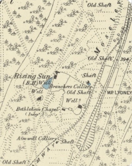
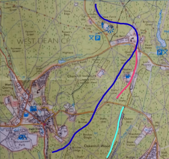
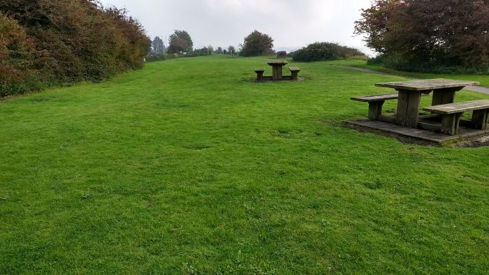
There are now two significant sculptures at the site. The first is the Roll of Honour sculpture which was commissioned by the Forest of Dean Local History Society to honour those who worked and were killed or injured in the mines and quarries of the Forest of Dean. It was buil by Graham Tyler and John Wakefield and was unveiled in 2005. It consists of three elements – stone, iron (represented by rusted steel), and coal (represented by carved and blackened local oak) – and stands around 11 feet (3.4 m) high. Stainless steel discs set into the sculpture represent the tokens carried by miners to determine who was below ground in the event of accidents.
The second is the Forest of Dean Geomap, a 900 square feet (84 m2) sculpture of the Geomap-New-Fancy
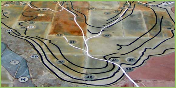
geology and mines of the area, was unveiled at the New Fancy picnic site in May 2008. It was commissioned by the local history society, who received a grant from DEFRA’s Aggregates Levy Sustainability Fund, and was constructed by sculptor David Yeates of Mitcheldean before being assembled on site. The rock strata depicted are built from samples of the rock they represent. Metal discs represent the locations of the main iron and coal mines and quarries, with black lines to represent coal seams and white lines for railway routes. It is flat and polished, but not shiny, and is intended to be walked on.
The Colliery

New-Fancy-Colliery-b-w-1
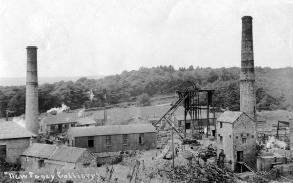
Wikipedia suggests thst the New Fancy colliery was opened by Edward Protheroe in 1827, as part of the Park End Coal Company in the Forest of Dean. It seems that he acquired the interest from his uncle in 1812. Details are scarce, however the 1841 Coal Awards confirmed the possession of the New Fancy gale to Edward Protheroe. In the Third Schedule to the 1841 Awards it is mentioned that in 1831 Edward Protheroe was granted a license to erect a pumping and winding engine at New Fancy but it is likely that this was not done as in a list of coal works in March 1841 there is no mention of New Fancy. The gale itself was certainly being worked by 1840, probably through the Parkend gale, as in that year Protheroe stated that he required a ‘better, cheaper, outlet’ for his New Fancy coals. The cheaper outlet would come about by sinking a shaft on the New Fancy gale thus avoiding the wayleave charged by the Crown on all coal from one gale passing through the barrier into another. The New Fancy gale award covered the coal in the Churchway High Delf, Rockey, Starkey, Park End High Delf, Little Delf and Smith Coal veins.

Parkend-New-Fancy-c1905
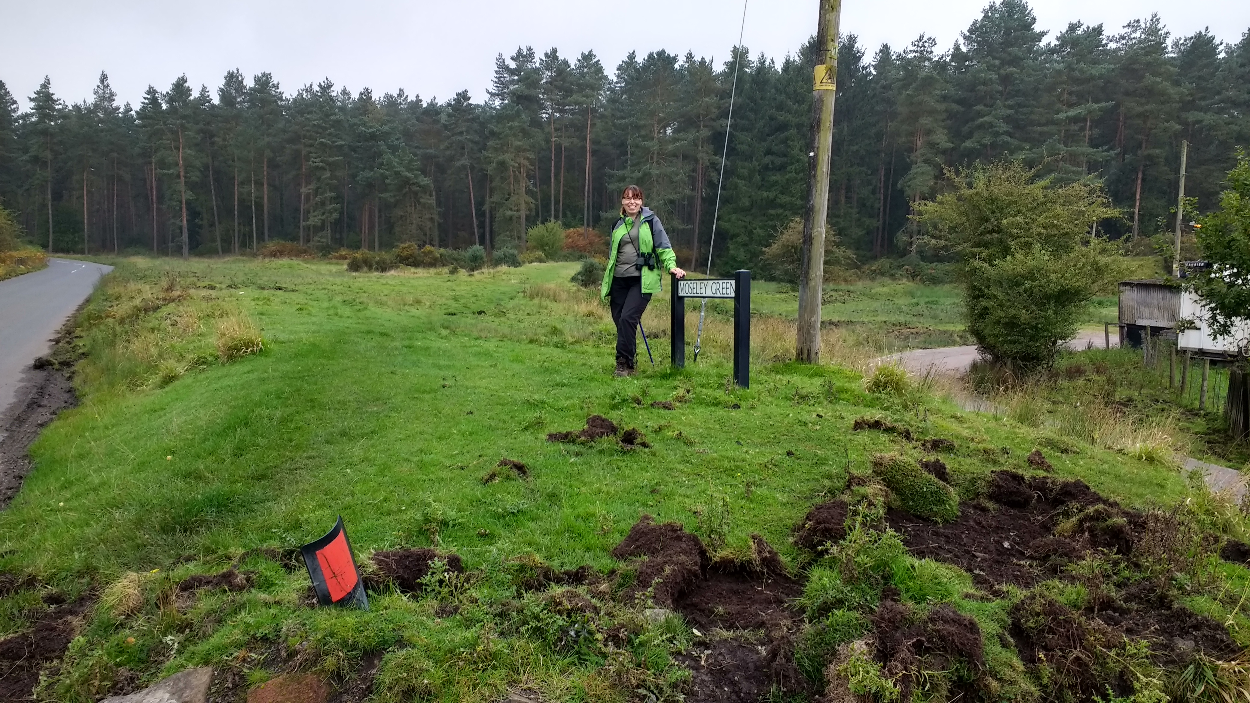
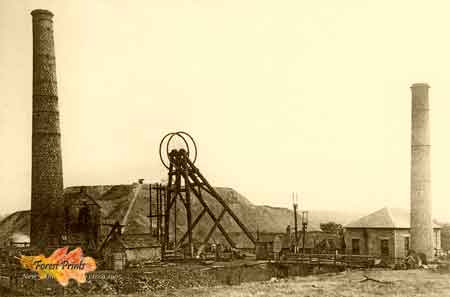
By around 1852 it seems that two shafts were being sunk. These seem to have been completed in 1857. At the first half-yearly meeting of the Forest of Dean Central Railway Company it was stated that the colliery ‘was in a forward state and will when opened afford large traffic’. The colliery was producing coal by 1860 when 250 tons a day were being sent over the Severn & Wye’s Kidnalls Mill, or Moseley Green, branch of the tramroad. A connection to this branch had been authorised and built in 1859. It was to be another ten years before the colliery gained a railway connection in the form of a branch of the Forest of Dean Central which was authorised under a Crown license dated 6th April 1868. The large traffic hoped for over this route diminished rapidly when the Mineral Loop was opened in 1872 and a connection was made to the colliery. It is likely that the rails on the Central’s connection had been removed by 1878.

New_Fancy_Mosely-Green
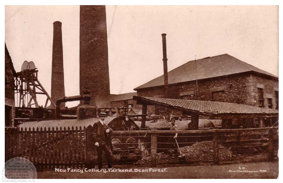
Wikipedia suggests that, by 1860, the Colliery was owned by Sully & Company and in 1885 was sold to the Parkend & New Fancy Collieries Company. However, this may be an oversimplification. By 1878 James Sully was the only remaining partner in the Park End Coal Company and the Parkend Coal Company Ltd. was formed to acquire the collieries. The subscribers to the new company were James Sully and Richard Sully, both described as coal merchants from Bridgewater, Somerset, John Nicholls, also of Bridgewater, William Unwin of Oxford, John Bailey, Sydney Thomas of Parkend House, colliery manager and Thomas Thomas.

Parkend-New-Fancy
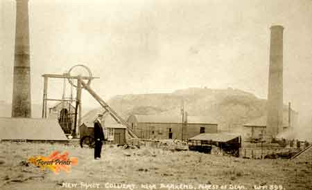
It appears that the new company may have been heavily in debt from the start. By 1880 it was in difficulties. At that time the company wasthought to possess nine-hundred acres of coal in the Starkey seam in connection with New Fancy. Probably the collieries were bought by a Mr. Jackson in 1881.
In 1883 the management of New Fancy were negotiating with the Great Western Railway, who worked the Forest of Dean Central, to be reconnected to their line at Howbeach as the rates via the Central to Lydney were 5d per ton cheaper. This was undoubtedly a ploy to gain cheaper rates from the Severn & Wye in which the colliery company was sucessful. However heavy mortgages led to closure in 1883 and a new confederation acquired the collieries in 1884.
New machinery was installed with the first compressed air coal cutters in the district and probably in the West of England being used. The reason for their introduction was the high cost of coal production at New Fancy due to the thinness of the seams. They averaged only 17 inches with the thickest being the Parkend High Delf at three feet.
In March 1885, the collieries were sold again to a new company called the Parkend & New Fancy Collieries Co. Ltd. From about 1888 onwards coal from the Parkend gale was worked out through New Fancy as the shaft was closer to the coal being worked and therefore haulage costs were reduced. In December 1889 a Severn & Wye minute records that the company had acquired the deep gales underlying their property and again asked if the S & W would give a concession on the coal rates as the colliery could be opened to the Central.
The company continued trading until in March 1892 the Parkend Deep Navigation Collieries Co. Ltd. bought up the company in exchange for 4,000 fully paid up £10 shares.
The Parkend Deep Navigation Collieries Co. Ltd. had been incorporated in October 1890 with an authorised capital of £100,000 in £10 shares. The subscribers were William Cooper, Parkend; William Esau Heard, Newport; John Witson, Cardiff; John Gething, Newport; William Thomas, Lydney; Arthur Graham, Parkend; and Percy Marfell of Lydney. The first 4,000 shares were allocated to the Parkend and New Fancy Collieries Co. Ltd. in consideration of their concern. A further 1,000 shares were issued to a John Griffiths of Willsbury for the purchase of the Rising Sun and Union Colliery from him. Up to 1904 only a further 739 shares were taken up as the number of members of the company was limited to fifty and it was not intended to invite the public to subscribe. Thomas Hedges Deakin was the Managing Director and Chairman of the company.
In 1914 electric equipment was installed to power pumping plant, haulage engines and coal cutting machinery. The generating station was alongside the Castlemain pumping engine at Parkend and a pole route was constructed to bring the power to the colliery.
The output of New Fancy steadily declined until final closure in August 1944. From 1940 it had averaged about 350 wagons per week.
The site of the New Fancy Colliery is a scheduled monument.
Railways
The Colliery was first served by a tramway, and then by two different railway lines … the Forest of Dean Central Railway and the Severn and Wye Railway Mineral Loop. The Forest of Dean Central Railway was very hopeful of a large coal traffic from the Colliery and was commercially dependent on that expectation. The Mineral Loop provided connections to a number of forest collieries and was a more successful venture than the Central Railway.


References
https://en.m.wikipedia.org/wiki/New_Fancy
http://lightmoor.co.uk/forestcoal/CoalNewFancy.html
https://rogerfarnworth.wordpress.com/2014/10/07/the-forest-of-dean-central-railway/