
The present hamlet of Moseley Green to the East of Parkend in the Forest of Dean is the location of our holiday cottage in September 2017. Historically it was alongside the Severn and Wye Railway’s Mineral Loop line. Prior to that two collieries are shown as existing on the site … Independent and Branchers. However, much of this industry was small scale and transient and records suggest a whole variety of different mines in the area.
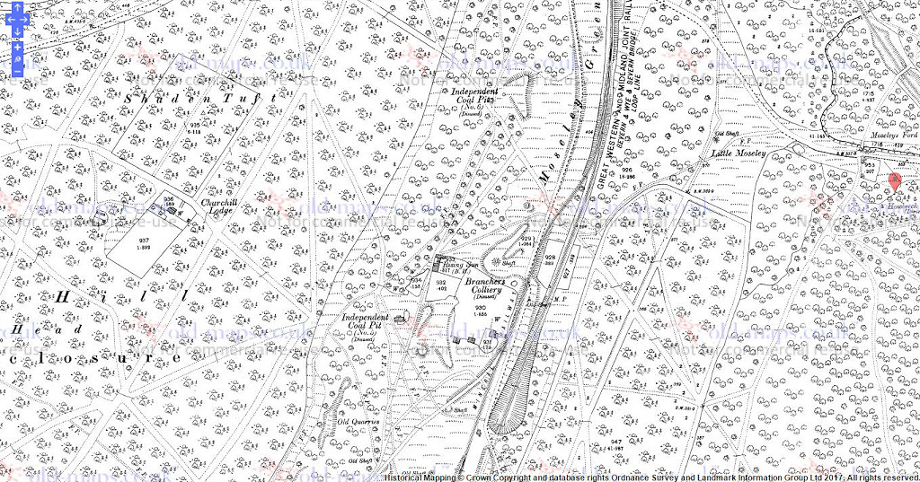
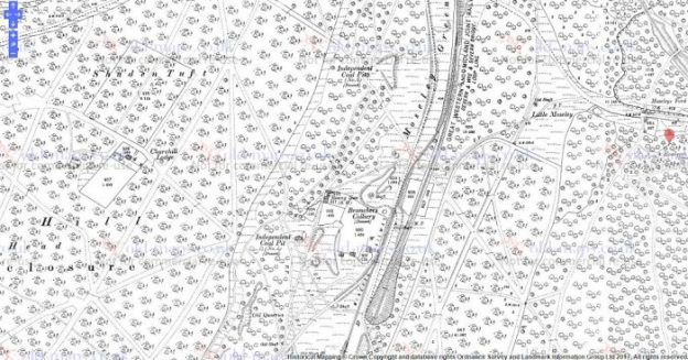
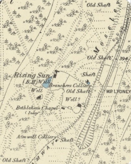
The map above is an extract from the 1901 Ordnance Survey Map and shows evidence of the Independent and Branchers collieries. The Rising Sun Pub is prominent on this map and had been in existence on the site since the 18th Century.
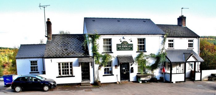
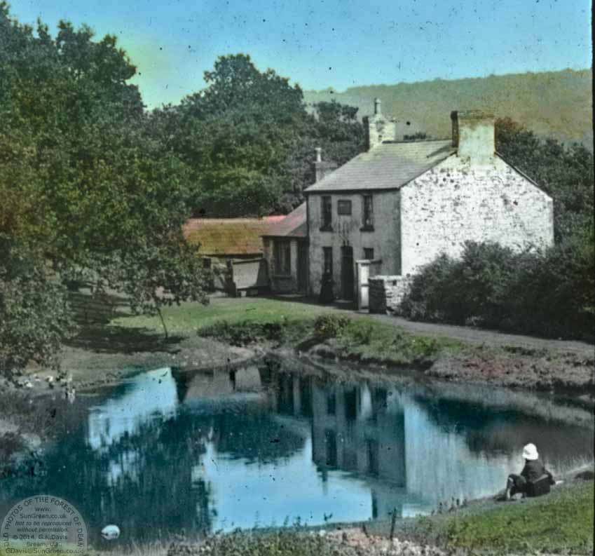
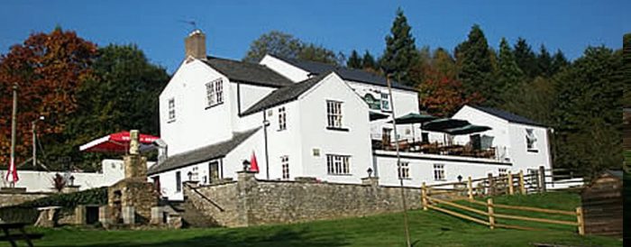
Of these three images, one is from around the turn of the century and was taken by the Rev. A J Lumbert. It is a glass plate that has been hand-coloured. The location of the pub was close to two pits and the railway line and miners of the Forest have drunk here over many years. In 2017, the pub buildings have been enlarged. As the other pictures illustrate.
The food offered is excellent!
Moseley Green has always been a small hamlet. There isn’t a great deal of information about its history. The following notes can be found at http://www.forestofdeanhistory.org.uk …..
“Moseley Green New Engine gales were granted in 1842-3, and there was a Brick Pit on Newmanshropshire gale by 1855. The early history of the colliery is uncertain, but it was connected to both the Birches and Kidnalls Mills branches of the Severn and Wye tramroad, and later (after 1874) to the S&WR’s mineral loop. The period 1860 to 1895 was a chequered one, and by 1883 the colliery was idle. In 1895, when it was purchased by Messrs Johnson and Shepherd, it had two shafts (540 and 516 ft in depth, through seams in the Supra-Pennane after 1905. After several changes of ownership, the gales were transferred in 1915 to the Parkend Deep Navigation Collieries Co. Ltd, owners of the nearby New Fancy Colliery, who installed a new electric winding engine.”
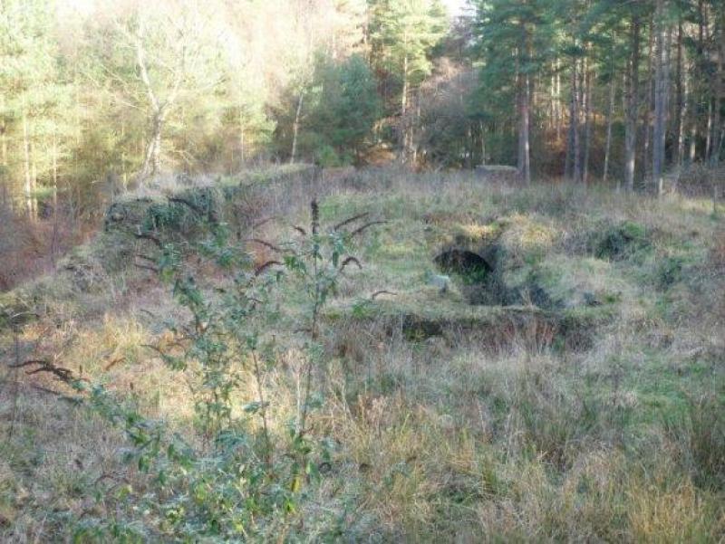
A survey undertaken from Parkend up the road past the school to Moseley Green in April 1834 noted that Moseley Green was… “full of pits part of which are now working but the greater part are abandoned and filled up.” (3) The area is covered with bell pits and the note might indicate that some were still at work at that time.
Reference is made elsewhere to Morgan’s Folly … a series of pits in the area of Moseley Green. Some relevant notes are in Appendix 1
The closure of some of the collieries at Moseley Green in the early 1870s is inferred by the visible reuse of some of the spoil heaps as embankments for the Severn and Wye Mineral Loop Railway which was constructed between 1870 and 187 (4:p106).
A reference is made to a Pluckpenny Rockey Colliery in a 1896 survey. At the time of that survey work had apparently ceased (5). The owner was W.H. Jones, Stag Inn, Yorkley.
Religion
There were a number of short lived attempts to establish nonconformist worship in Moseley Green. The Congregationalists were, in 1860, holding services at Berry Hill and Coalway Lane End and in 1865 they had a small congregation at Moseley Green. That congregation, worshipping in a room at an abandoned colliery, included Mary Young, keeper of the Yorkley turnpike gate, with whose assistance Samuel Ford of Blakeney built a chapel at Moseley Green. The chapel, opened in 1866, was called Bethlehem and was sold to the Primitive Methodists in 1894.
Primitive Methodist services held at Moseley Green from 1859 were discontinued in 1864 for want of a congregation. They were resumed in 1867 and a chapel called Providence, standing north-east of the Barracks, was registered in 1879. In 1894 the meeting moved to the Independent chapel some way south but in 1898 it returned to its former home. The return led to a drop in support and in 1907 a new chapel was built on the Blakeney-Parkend road to the south. That chapel, which was abandoned in the mid 1950s, fell into ruin but in the late 1980s it was rebuilt as part of a new house.
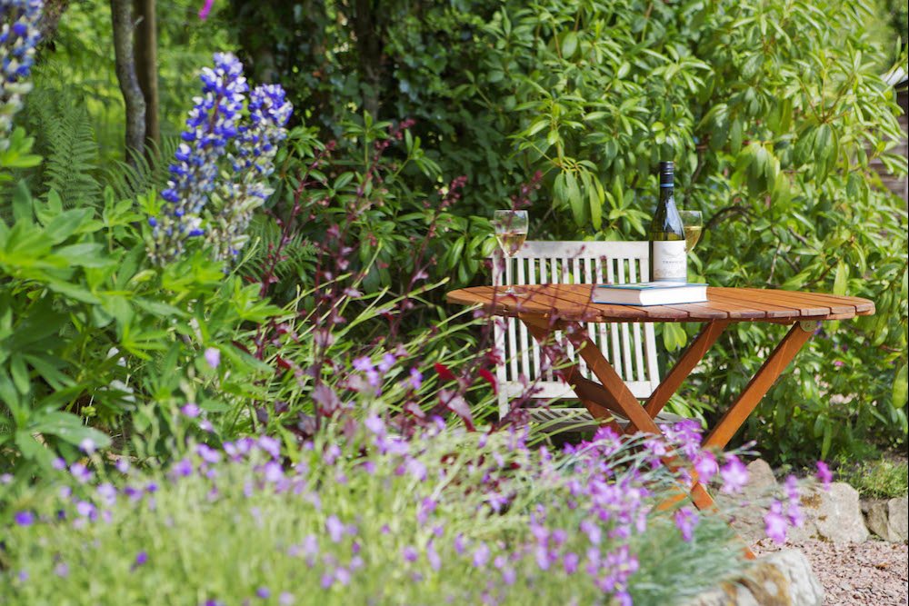
Rosebank Cottage (http://www.rosebankholidaycottage.com)
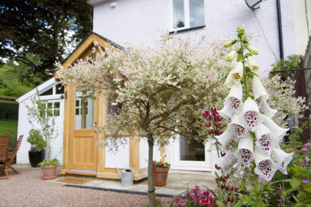 In 2017, we stayed in Rosebank Cottage in Moseley Green. The cottage was one half of what was built as the Methodist Chapel in 1859 but closed in 1864. In 1960 the chapel was finally converted into two cottages losing most of its ‘chapel’ features. The 1881 Ordnance Survey clearly shows Rosebank Cottage cand its neighbour as Bethlehem Chapel.
Railway
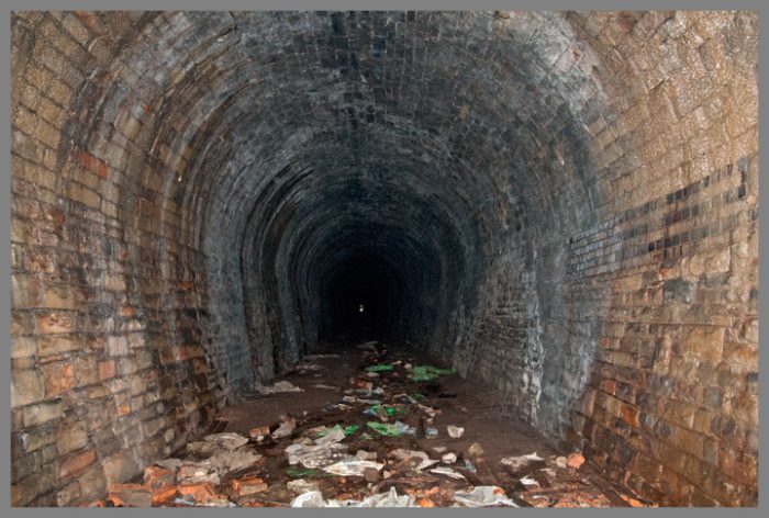
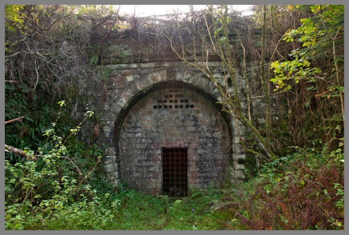
Moseley Green sits alongside the Severn and Wye Joint Railway’s Mineral Loop which closed in the 1950s. It is just north of the north portal of the 503yd Moseley Green Tunnel. The tunnel must have been a nightmare for engine drivers. The rising grade of 1in 40 would have placed significant demands on the Pannier 0-6-0s in use in the forest, particularly when pulling a full load of coal wagons.
References
1. http://www.forestofdeanhistory.org.uk/resources/sites-in-the-forest/brick-pit
2. http://lightmoor.co.uk/forestcoal/CoalMorgansFolly.htmlhtml
3. Gloucestershire Society for Industrial Archaeology Journal for 2009 pages 14-22
4. https://content.historicengland.org.uk/images-books/publications/forest-of-dean-mapping-project-nmp/FoD_Final_Doc_web.pdf.
5. http://archive.pdmhs.com/1896%20Lists/1896-66.htm
Appendices
Appendix 1 – Morgan’s Folly
Lightmoor Press has identified activity in the Moseley Green area, recorded under the heading of Morgan’s Folly ….http://lightmoor.co.uk/forestcoal/CoalMorgansFolly.html
MORGAN’S FOLLY COLLIERY, No. 1
7 February 1843 to Thomas Morgan of Arthurís Folly near Parkend for a pit situate on Moseley Green about 90 yards north of Cockshot Inclosure and about 65 yards east of the Parkend – Blakeney turnpike road, to get the coal from the Coleford High Delf, Yorkley and Whittington veins.
MORGAN’S FOLLY COLLIERY, No. 2
27 June 1843 to Thomas Morgan, for a pit situate on Moseley Green about 250 yards on the deep side of the gale called Morganís Folly No. 1 to get coal from the Coleford High Delf and all unalloted veins between it and the Oaken Hill Delf.
MORGAN’S FOLLY COLLIERY, No. 3
11 March 1847 in equal parts to Samuel and Thomas Morgan, of the Folly, for a pit situate on Moseley Green, to get coal from the Coleford High Delf and all the unalloted veins above the same and below the Churchway High Delf or Oaken Hill Delf veins. On the land side of the deep workings of Morganís Folly No. 2.
F3 958. F3 291.
June 1859 Morgan’s Folly No. 3, Samuel Morgan proprietor.
Midsummer 1861 Arrears of rent for Morgan’s Folly No. 3 stand against Saml. and Thos. Morgan, Whitecroft.
F3 189
27 May 1895 Messrs. Bruton, Knowles & Co. will offer the Moseley Green Collieries and the plant etc. in one lot on Wednesday next. If the colliery not sold the auctioneers will offer machinery.
Connected to Severn & Wye by a siding.
Three gales in deep and three overlying viz. Moseley Green New Engine Colliery, Morgan’s Folly No. 1 Colliery, Morgan’s Folly No. 2 Colliery, Morgan’s Folly No. 3 Colliery, Moseley Green New Engine No.2 Colliery, and Two Brothers Colliery.
Total area of coal 1,700 acres, average thickness exceeding 3í 2î. 7,000,000 tons.
With the winding engines, two shafts, boilers, pumps, railway siding, foremanís house, workshops etc.
Wednesday May 29th 1895.
Sold to Shepherd and Johnson for £460.

Hi Rodger,
Always loved your articles on the Forest of Dean.
Did you know about the Stone which is marked on old maps and is still in situ over the Blackpool Brook on the access road to Mallards Pike which is close to Moseley Green?
It has an inscription W.H.S.D. a date of 1866 and No 1 engraved on it.
Do you have any idea as to why this stone is there, if you do could you let me know please?
Sorry, Peter, I do not know about the stone that you mention. If you live in the area, you might want to try contacting the Dean Heritage Centre to see what they know.
Thank you and I will try Dean Heritage Centre
Peter
Hi Rodger,
Ref the Boundary Stone on the Bridge over the Blackpool Brook on the access road to Mallards Pike near Mosely Green. {SO638088}
On re-examination the inscription reads:-
V.H.A.S.D.
No 1
1866
I have spoken to a well known local historian, Mr John Saunders, who has come up with an explanation after due consideration.
The letters stand for Viney Hill All Saints District. No 1 Boundary Stone, so there could be others and 1886 was the date when the Ecclesiastical District, or Parish, was created.
I have included a few notes about the District or Parish of Viney Hill and the of All Saints Church where amongst other things a Gipsy King was berried after the traditional burning
of his caravan and my son and daughter in law were Married.
Notes on All Saints Ecclesiastical District
Before 1800 the royal demesne land of the Forest of Dean was extra parochial and had no churches or parishes within its boundary.
The rector of Newland Church, was entitled under grants of 1283 and 1305 to the tithes of Whitemead and of new closes and assarts within the Forest.
Newland Church was regarded as the Foresters’ parish church.
In the 1831an Act of Parliament was passed to divided divide The Forest of Dean into 3 ecclesiastical districts of East Dean Ecclesiastical District, West Dean Ecclesiastical District, and Parkend Ecclesiastical District.
The church of St. Paul in Parkend Ecclesiastical District was consecrated in 1822. It was built by Henry Poole, minister of Bream and Coleford chapels.
Henry Poole organized missions from St. Paul’s church and in the early 1850s he built school-chapels between Viney Hill and Oldcroft and also at Blakeney Woodside with the help of Charles Bathurst and Edward Machen, deputy surveyor of the Forest.
The area between Viney Hill and Oldcroft became known as St. Swithin’s.
The church of All Saints, Viney Hill was begun in 1865 and consecrated in 1867. It was built as a memorial to Charles Bathurst of Lydney Park to by his wife Mary and his brother and heir, the Revd. W. H. Bathurst on Forestry land adjacent to the Lydney Park Estate.
In 1866 All Saints was assigned an Ecclesiastical District which included Blakeney Hill and Yorkley Slade taken from St. Paul’s Ecclesiastical District.
All Saint’s Church is built of local red sandstone with grey sandstone dressings in a late 13th-century style with an apsidal chancel flanked by quadrant chapels and a nave with north transept and south aisle and porch with two bells hanging in a bellcot,
The patronage was vested in W. H. Bathurst and descended with the Lydney Park estate until 1936 when Viscount Bledisloe gave it to University College, Oxford.
Engraved on the Boundary Stone beside the Blackpool Bridge near Moseley Green is
V. H. A. S. D.
No. 1
1866
Dear Peter
Thank you for this. It will appear in the commments