This post is a short addendum to my post about the pre-railway age and the tramways of Pembrokeshire. In that post there was a section about the Porthgain to Abereiddi Tramway. In writing about that tramway, I failed to include details of the 3ft-gauge clifftop tramway which linked the slate quarry at Pen Clegyr Point with Porthgain.
I also failed to note the detail of the tramway tunnel between St. Bride’s Quarry and Porthgain Harbour. The original post can be found here:
Much of this current post about the Clifftop Tramway is summarised from a book by R.C. Jermy – “The Railways of Porthgain and Abereiddi,” which is an excellent study of the location. [2]
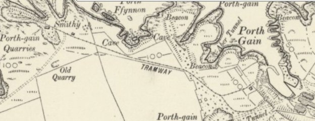
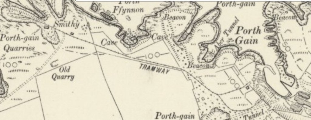
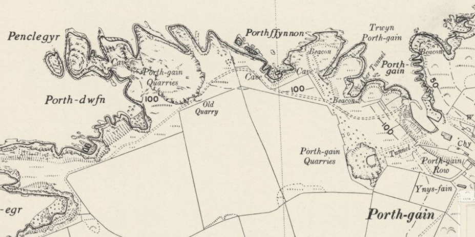
The 1906 6″ OS Map shows the clifftop tramway. [1]By the time the 1906 survey was undertaken the tramway tunnel and St. Bride’s Quarry were abandoned and the tramway rails through the tunnel had been lifted. The two short branches of the clifftop tramway can be seen to good effect on this map extract. [1]
By 1906, lines which linked St. Bride’s Quarry with the harbour via two inclines had been removed. The later tramway tunnel was also redundant and the tramway rails had been lifted. “Traces of the earthworks and inclines, including the lines to the spoil tips, are the only remains on the 1906 map. There remained on the clifftop just the lines of the horse-drawn tramway fetching stone from the quarries at Pen Clegyr Point. From loading sidings in the quarry the line entered a shallow cutting passing a small smithy on the right, after which maps indicate a short passing loop. The line then climbed upwards towards the summit close to Pentop Gate at which point it curved right, passing the weighing machine which measured the wagon weights. The line then forked into two, one track leading to each of the stone crushers located above the storage hoppers. Small passing loops were located on each of these tracks.” [2: p17]
There is, for me, an interesting connection between this area and the Forest of Dean. In 1900, the Forest of Dean Stone Firms were registered in Bristol.”This concern took over the harbour and mining interest at Porthgain but after November 1909, and until it was finally wound up in 1922, its interests were managed by United Stone Firms, another Bristol-registered Company. This firm raised a mortgage of £200,000 on the Dean Forest and Porthgain interests in 1910 and indeed this was the time when the crushed stone demand was reaching its peak. Sailing ships and powered vessels called regularly, the quarry and harbour railway systems were well developed and the Company ran its own fleet of steam coasters, each of about 350 tons.” [2: p10]
However, by 1913, despite the success of its Porthgain operations the parent company passed into the hands of the receiver. It remained so until 1926 “when it was reorganised and taken out of receivership by Walter Bryant of Coleford, Gloucestershire, who formed United Stone Forms (1926) Limited.” [2: p10]
However,by July 1931, that company became insolvent and was closed by 31st August 1931.
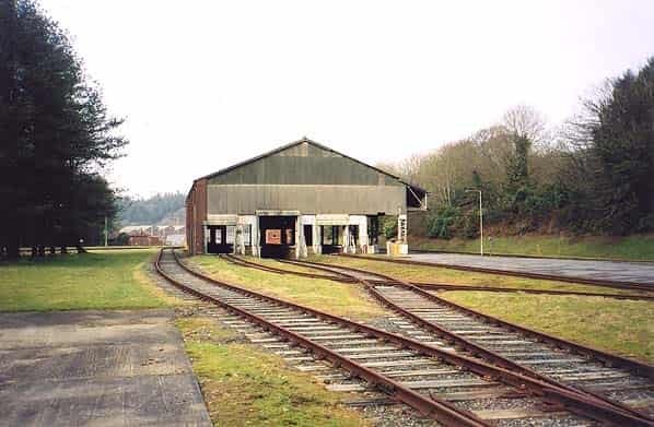
The 1948 revision of the 6″ Ordnance Survey was published in 1953. As far as the map extract is concerned all remnants of the clifftop railway have disappeared. This seems to be an over simplification of the situation as a number of remnants were still present even if not recorded. [5] The line of the track can still be traced as a levelled strip on the clifftop, adjacent to the path to Porthgain harbour. [4] R. C. Jermy includes a number of photographs, taken in 1951 by H. Townley, which show the engine shed (with ‘Newport’ gently rotting away on one of the roads) and the remains of two traction engines, ‘Daisy’ and ‘Dinah’. Dinah was sited at Pen Clegyr and was used as a winding engine. Daisy sat on the clifftop. [2: centre-pages]
Jermy notes that “by 1908 the demand for roadstone had increased and the Forest of Dean Stone Firms made the decision to invest in a steam locomotive for operating the clifftop system. … It was realised that with the arrival of a heavy locomotive complete relaying with heavier track would become a necessity. Accordingly 200 sleepers were ordered … and … between 20th and 22nd January, 1909 the tramway was [re-laid] with heavy rails and sleepers from Pentop Gate by the water tank to the winding engine house at the top of the incline leading from the lowest quarry levels. A new engine shed was constructed, the roof over the single road being completed just six days after the arrival of the first locomotive! An inspection pit was located between the rails in the shed. Later, in November 1909 a ten ton weighbridge was installed in a brick building close to the water tower.” [2: p18]
Later, two further locomotives arrived at Porthgain necessitating the addition of a second road to the engine shed.
Records appear to show that one of these locomotives, Singapore, was too heavy for the tramway rails in place when they arrived and as a result in some expenditure was necessary to upgrade the tramway. In fact, the prevailing weather conditions and the weight of the locomotives seem to have resulted in a significant regular maintenance programme being implemented.
Jermy shows two plans of the railway – the first shows it much as on the 1906 6″ Ordnance Survey. He dates his sketch plan to 1905. [2: p20]. The second is the result of a survey of the line by Jermy in the 1980s which seems to show the small network at its fullest extent in around 1925. [2: p21] This sketch plan shows the engine shed in its position on the Northeast side of the St. Bride’s Quarry, three roads serving the crushers and hoppers, a small Yard on the North side of St. Bride’s Quarry, a weighbridge and water tank to the Northwest of the Yard, a long straight length of line with two tracks, one known as ‘The Cutting’, the other as ‘Jerusalem Road’. These two line led to the Upper Level of Pen Clegyr Quarry and, via a cable-worked incline to the lower level of the quarry. [2: p21]
Locomotives
The first locomotive was named ‘Portgain‘. It was built in 1909 by Andrew Barclay in Kilmarnock. It was Works No. 1185. … No. 1185 was an 0-6-0T with 7″ x 13″ outside cylinders, 2ft 2½in wheels 3ft gauge. … Despatch Date: 26th July 1909. [2: p23][3] This locomotive was out of use by 1929 and was scrapped on site shortly after 1931. [4]
The second, ‘Charger‘ was built in 1891 by W.J. Bagnall in Stafford and had the Works No. 1381. It had a copper firebox, brass tubes and two 5½in x 10in outside cylinders. It passed through a number of ownerships before, in September 1912, it was moved to Porthgain. [2: p29-30] This locomotive was scrapped shortly after 1931. [4]
The third, ‘Singapore‘, was a 0-4-2 saddle tank built at the Kerr-Stuart works in Stoke-on-Trent and had Works No. 659. It had 9½in x 15in outside cylinders. It was built in 1899. It was first bought by the contractor G. Pauling and Co. It was shipped to Ireland and was used on the Burtonport Extension contract which Pauling’s were undertaking for the Londonderry and Lough Swilly Railway. Sold in 1903, it went to Scotland and remained there until 1912 when it was transferred to Porthgain. [2: p31-33] This locomotive was out of use by 1929 and was scrapped on site shortly after 1931. [4]
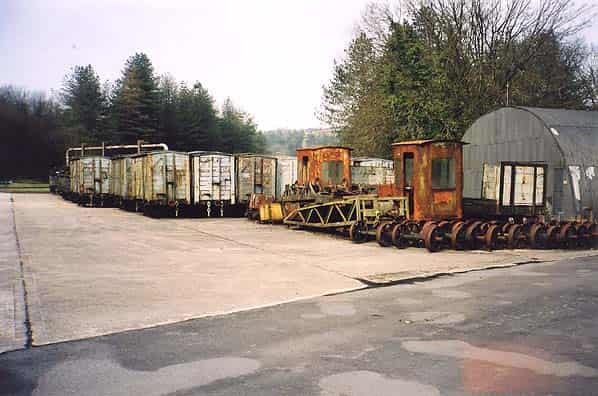
The fourth locomotive was ‘Newport‘, a 0-4-0T loco. It was built by Hudswell, Clarke and Company of Leeds. It was originally built as a 2ft 10in gauge loco with Works No. 311 in 1889. In 1900 it was owned by Kellett & Sons who worked on the Hagley to Frankley section of the Elan Valley Aqueduct. It went through a number of ownerships after this before entering service at Porthgain in May 1929 after an overhaul. [2: p33-36] This locomotive remained in the Porthgain Railway Locomotive Shed after closure until scrapped in 1953. [4]
This post includes a selection of news items about Kenya Railways in the period from 2018 to the Autumn of 2022. The items included are by no means exhaustive but they might be of interest! ……..
The Birth of a Nation: preserving records on the Kenya-Uganda railway line (EAP1143)
In 2018 the British Library funded a small pilot project undertaken in Nairobi Railway Museum’s archive. This was a low cost 6 month pilot which identified the condition of the archived documents and photographs and improved storage and access to them.
The photographs which were digitised all seem to predate the construction of the railway and document the life and times of people who lived on its route. [1]
The Standard-Gauge Line
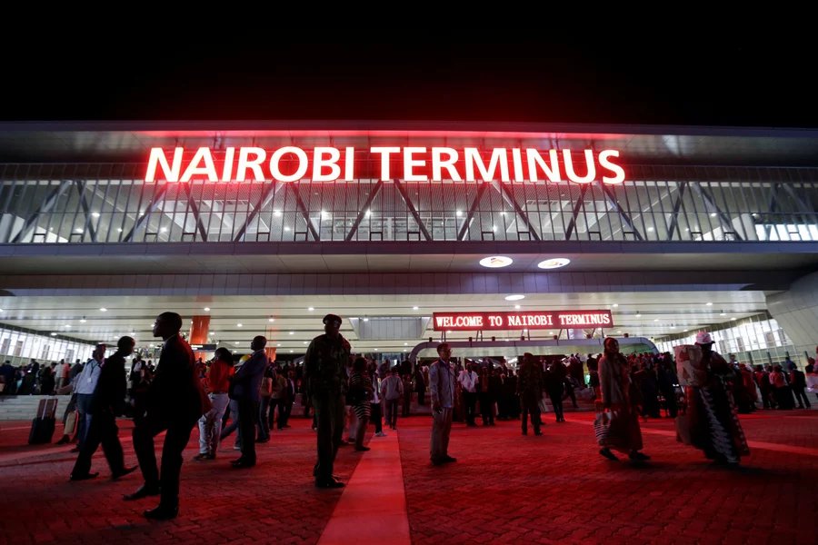
In 2018, NPR reported that the “Standard Gauge Railway station in Nairobi is easily the most impressive public building in Kenya.” [8] The station is “adventurous. It’s all gray and modern. Geometric shapes form an abstract locomotive, and red neon announces the “Nairobi Terminus.”” [8]
The Standard-gauge Railway Station at Nairobi. [8]
NPR continues: “The train runs 293 miles from Kenya’s capital city to the port of Mombasa and back twice a day and represents the biggest infrastructure project since Kenya’s independence 54 years ago. The Chinese financed it; a Chinese company built it; and the Chinese will operate it for many years to come. … The project, which launched in the summer of 2017, has not only come to signify Kenya’s ambitions, but also China’s ambitions on the African continent. In the past decade, China has become the biggest lender to governments in Africa. The money has helped build ports, roads, bridges, airports and trains. But critics warn the loans are full of traps that could leave African countries in the lurch. Kenya alone owes $5.3 billion to China.” [8]
On 16th October 2019, VOA News reported that Kenya opened the second phase of the Standard Gauge Railway Project: “Kenya’s President Uhuru Kenyatta officially opened on Wednesday the second phase of his flagship infrastructure project: a Chinese-funded and built railway that will eventually link the port of Mombasa to Uganda. … The latest stretch of track cost $1.5 billion and runs from Nairobi to the Rift Valley town of Naivasha.” [9]
After the official opening, the president then joined the first ride along the line. … “The train stopped at every station, where a cheering crowd awaited the president. He promised them that the new railway will bring prosperity. … Kenyatta said that if the railway comes here, development also comes here.” [9]
The new track is 120 kilometers (75 miles) long and has 12 stations. Passengers can ride the trains, but the railway is mainly for cargo. The track will eventually lead to an inland container depot, (see below) from where containers will be distributed to Uganda and Rwanda, and to South Sudan. [9]
On 20th August 2021 the Ugandan newspaper, ‘The Independent’ reported that Kenya’s Standard-gauge railway line transported 2.31 million tons of cargo between January and the end of May that year: “an increase of about 45 percent from the similar period in 2020, according to data released on Thursday from the Kenya Railways Corporation.” [10]
“The rise in cargo volumes saw an increase in revenue generated during the months to 6.2 billion shillings (about 57 million U.S. dollars), up from 41.4 million dollars generated from January to May in 2020, it said. … The number of passengers using the train during the first five months of 2021 nearly doubled amid COVID-19 pandemic. … Some 601,201 passengers were ferried between the capital Nairobi and the coastal city of Mombasa during the period, up from 330,232 in 2020 when the country grappled with COVID-19 pandemic, the corporation said. … This generated revenue of 5.9 million dollars, up from 3.3 million dollars generated between January and May in 2020.” [10]
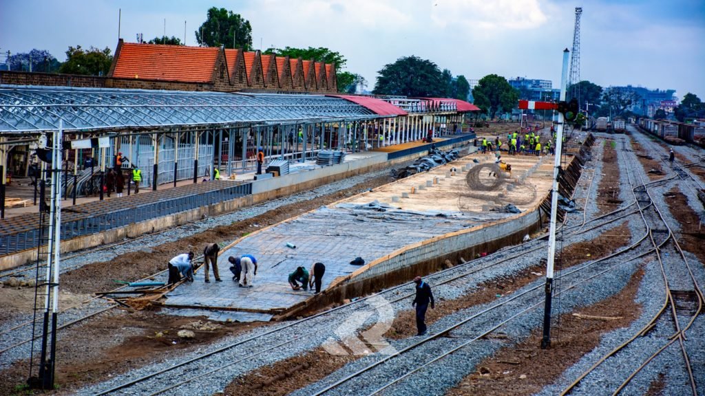
Refurbishment of Nairobi Central Station
Major renovations at Nairobi Central Station began on 27th July 2020. By January 2021, the work was well-advanced. Kenya Railways reported that the work would facilitate the use of the new DMUs due to arrive in the country.
Renovation work at Nairobi Central Station in January 2021. [5]
Kenya Railways stated on 13th January 2021 that, “as the rehabilitation works continue[d], stringent measures [were] put in place to safeguard daily commuters as they access[ed] the station.” [5]
Designated boarding points were set for various trains to facilitate safe movement of passengers within the Nairobi Central Station. For instance, Kikuyu and Ruiru trains, the boarding point was designated on the Western end of the Nairobi Central Station and it was to be accessed from Railways Police station. While passengers boarding Syokimau & SGR Link trains boarded the trains from the Eastern end of the station with the access point being adjacent to Guava restaurant.
Kenya Railways stated that, “The rehabilitation of Nairobi Central Station will not only give it a new face but also show KR is dedicated in making transportation better.” [5]
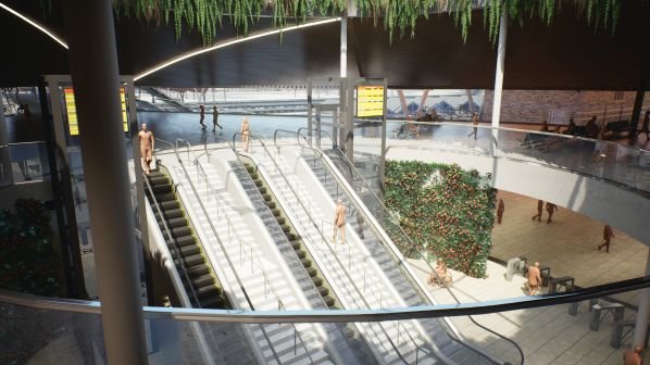
Plans for the full renewal of Nairobi Central Station were published in May 2022. The project has been sponsored by both the British and Kenyan Governments.
Design office view of the proposed renewed Central Station. [6]
THE British and Kenyan governments unveiled the final design of Nairobi’s new Central Railway Station and surrounding public area, which has been developed as part of the Nairobi Railway City redevelopment programme. [6]
The IRJ reported that, “The design was developed by SNC-Lavalin subsidiary Atkins and submitted to Kenya Railways and the Ministry of Transport. … The station is designed to accommodate up to 30,000 passengers per hour at peak periods, and will have 6000m2 of concourse space. The station will offer a new covered public space for the city with retail outlets and other amenities …. It features separate entrance and exit routes to avoid conflicting flows and ensure passengers can get to and from the platforms efficiently. … Three existing platforms will be joined by six additional passenger platforms, and four dedicated freight lines will be built. Two platform bridges will be built, with one for passengers entering the station and one for passengers exiting.” [6]
A few design office perspective views are shown below:
The SGR to MGR link at Naivasha
In July 2022, President Uhuru Kenyatta officially commissioned the Standard Gauge Railway – Metre Gauge Railway Passenger Rail Link at the Kenya Railways Mai Mahiu Station in Naivasha, Nakuru County. The ceremony took place on Tuesday, 26th July 2022.
The 5km link will enable passengers traveling to Western Kenya by train to switch from the standard-gauge service to that of the metre-gauge and vice versa. Kenya Railways reported that it would as a result be possible to travel exclusively by rail from Mombasa through Kilifi, Kwale, Taita Taveta, Makueni, Machakos, Kijiado and Nairobi onwards to Nakuru, Kisumu, Eldoret, Kitale, Nyahururu, Nanyuki, Malaba and Bungoma. [2]
Naivasha Inland Container Depot
On the same day (26th July 2022) the Naivasha Inland Container Depot (ICD) was officially opened by President Uhuru Kenyatta.
The Naivasha ICD facility which incorporates both the Standard Gauge Railway and the Metre Gauge Railway line will handle mainly transit cargo to the Great Lakes Region including Uganda, South Sudan, DR Congo, Northern Tanzania, Rwanda, and Burundi, which account for around 30% of imports and exports through the Port of Mombasa.
The SGR/MGR Link referred to above will greatly facilitate the transshipment process. All Transit cargo can now be delivered to the facility straight from the Port of Mombasa as either Through Bill of Lading (TBL) or merchant haulage (Non-TBL), while exports and empty containers can also be consolidated at the Naivasha ICD and railed to the Port of Mombasa for onward shipping.
Kenya Railways reported that, “The depot is linked to the Mombasa Port container terminal by a rail-tainer service on the Mombasa to Suswa Standard Gauge Railway line. It will serve to bring port services closer to customers and reduce congestion at the Port of Mombasa, Nairobi Inland Container Depot and on the roads. It is convenient for East African partner states who will not have to cover an entire 572 kilometres by road between Mombasa and Naivasha. From Naivasha ICD to Malaba Railway Yard, cargo will be transported over 36 hours and it will cost $860.”
Kenya Railways also affirmed that, “The Naivasha ICD includes a one-stop centre for ease of operations and efficient service delivery. The port houses all the Government agencies involved in handling of cargo namely Kenya Railways, Kenya Ports Authority, Kenya Revenue Authority, Kenya Bureau of Standards, Port Health (Public Health) and Revenue Authority officers from partner states of Uganda, Rwanda and Tanzania.” [3]
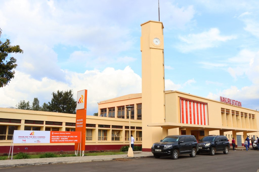
Nakuru Railway Station
President Uhuru Kenyatta officially commissioned the revitalized 217km Nakuru-Kisumu Metre-Gauge Railway (MGR) and the 465km Longonot–Malaba segment as well as the refurbished Nakuru Railway Station.
Kenya Railways reported on 28th July 2022 that the re-commissioning had taken place: “The iconic Nakuru Railway Station is a key transit station for cargo and passenger train services to and from Western Kenya, and is the aggregation hub for farm produce from the agriculturally rich Central Rift region for onward freight to the Coast for export.” [4]
“Nakuru town started as a railway station on Kenyan-Uganda railway line at the turn of 20th century. It was built in 1900 and later expanded in 1957. It sits on the east side of the centre of Nakuru. The town is part of the famous ‘White Highlands settlement’ areas established by the British during the colonial era. The areas surrounding Nakuru town are mainly known for their vast agricultural potential especially cash-crop farming i.e wheat, barley, pyrethrum, sisal, maize and beans. Nakuru Railway Station was built in order to serve the rapidly growing economy of the town.” [4]
Refurbished Nakuru Railway Station [7]
“Later branch lines were built to link the station to farming areas. Among these was the line linking the station to the sisal producing Solai area. Just 6.9 kilometres from Nakuru town lies Nakuru Junction station. This is the point at which the lines to Malaba and Kisumu diverge.” [4]
Suburban Services in Nairobi
Nairobi Commuter Rail Services now run regularly to Ruiru, Embakasi Village, Limuru, Syokimau and Lukenya in Kitengela. There is also a Madaraka Express Commuter Service that operates between Nairobi Terminus and Ngong station and a link service between Nairobi Central Station and the Standard-gauge Station runs at 0630hrs, 1200hrs and 2010hrs each day. [11]
A holiday in West Wales in the early Autumn of 2022 led to a little research on the railways in the area.
This is the sixth article about Pembrokeshire’s Railways. The first focussed on the pre-railway age, the second focussed on the mainline railways of the county. The third article focussed on the industrial railways in the vicinity of Milford Haven. The fourth and fifth on the Saundersfoot Railway in Pembrokeshire. The links to these posts are provided below. This article concentrates on the railways associated with RNAD Trecwn (the Royal Navy Armaments Depot at Trecwn).
TheRoyal Navy Armaments Depot at Trecwn (RNAD Trecwn)
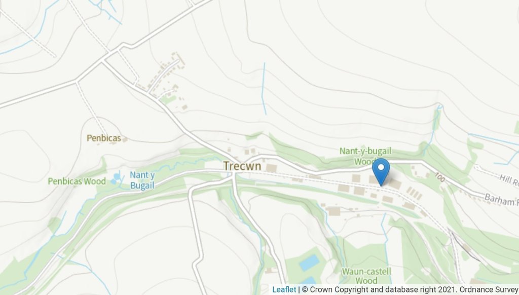
RNAD Trecwn is, in the 21st century, a decommissioned Royal Navy Armaments Depot, south of Fishguard in the village of Trecwn, Pembrokeshire, West Wales.
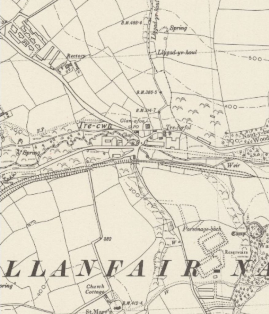
It was built in 1938 to store and supply naval mines and munitions ordnance to the Royal Navy. The depot apparently came into its own during the cold war. During those times 400 permanent workers were employed at the site, housed in an MoD built small town. The site had an on-site, 2ft 6in (762mm) narrow gauge railway, built using copper to reduce sparks. Weapons were both delivered to the site and then distributed using standard gauge rail to Fishguard, Neyland for Milford Haven, and latterly Pembroke Dock. [56]
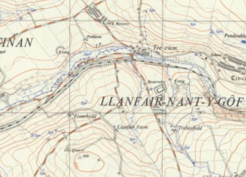
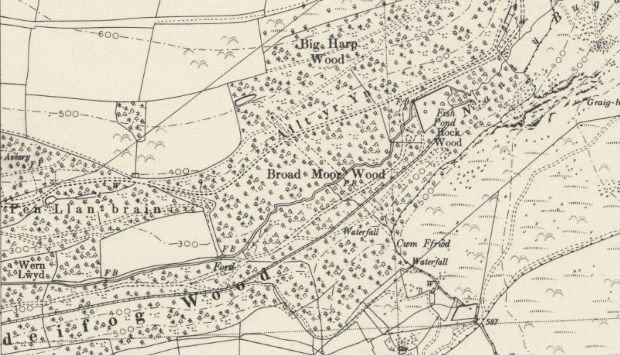
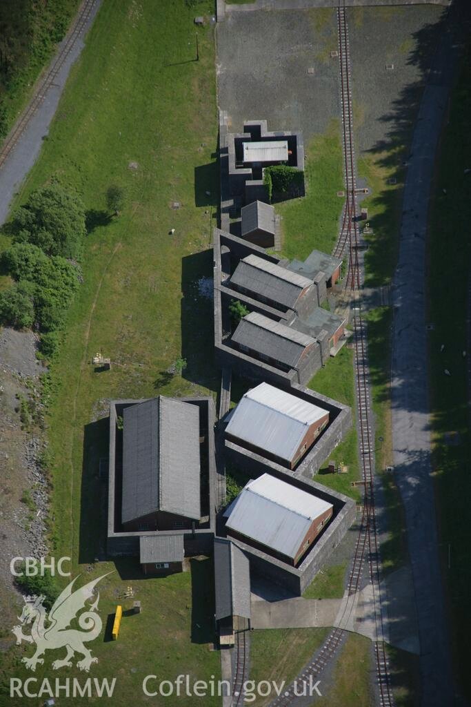
Trecwn as shown on the 1948 revision of the 6″ Ordnance Survey published in 1953. A series of three sidings are shown to the South of the main RNAD site. [57]
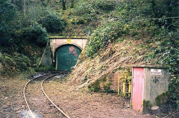
The Standard-gauge Branch Line and Sidings – Just south of the main entrance to RNAD Trecwm and the main security fence to the site was a single railway platform, for workers access to the depot. Within the security fence, a marshalling yard of 8 parallel loops existed, shunted by a dedicated MoD diesel hydraulic shunting locomotive. The line then extended on down the valley, through a gauge exchange shed for access to the narrow gauge network, and then provided direct access to the 58 cavern storage chambers via a series of herring-bone shaped sidings. [59]
Supply trains would run along the dedicated branch-line from the site: to Fishguard Harbour; to Neyland for Milford Haven; and Pembroke Dock. At Fishguard the line extended beyond the ferry terminal at Fishguard Harbour railway station, continuing along the breakwater to a single line spur, allowing for transfer of munitions to Royal Navy ships. [59]
These next few images show the Trecwn branch-line. The first shows its junction with what was the GWR line to Fishguard from which the branch runs Northeast towards Trecwn …
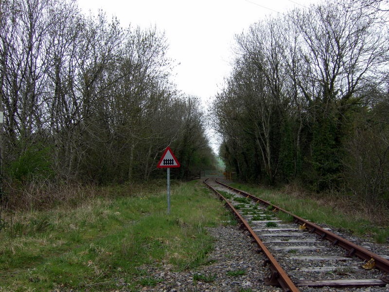
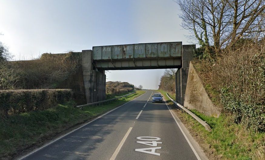
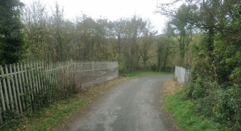
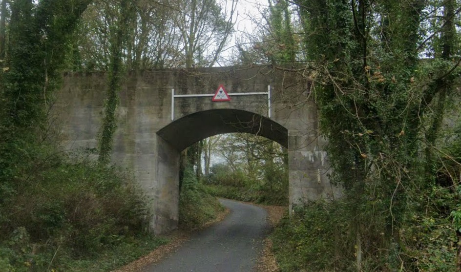
The Trecwn branch-line junction with the old GWR as shown on the 1951 1:25,000 Ordnance Survey. [60]The ESRI satellite image from the National Library of Scotland has the route of the Trecwn Branch-line imposed on it. [80]The view at the junction from a train window in 9th August 2007, (c) Ceridwen, authorised for use under a Creative Commons Licence (CC BY-SA 2.0). [238]A little to the South of the junction, a lane crosses the branch. This photograph looks along the line to the accommodation crossing on 5th May 2010, (c) Ceridwen, authorised for use under a Creative Commons Licence (CC BY-SA 2.0). [239]The view East along the line on 23rd July 2006. (c) Stephen McKay, authorised for use under a Creative Commons Licence (CC BY-SA 2.0). Stephen comments: “Taken from an accommodation level crossing looking along what was once a meandering branch to Clunderwen. [241] That route was abandoned in the 1940s, but a stub was retained to give access to the Royal Naval Armaments Depot at Trecwn.” [240]The view from the North along the A40 of the bridge carrying the branch over the road. [Google Streetview, March 2022]The view of the same bridge from the South [Google Streetview, March 2022]After a short distance running Northeast, the standard-gauge line runs adjacent to the main gates of Trecwm on an East-West axis before turning South and the East again. [60]
The depot was decommissioned in 1992. All 58 cavern storage bunkers and the extensive above ground network of storage sheds and other military buildings remain in place. Ownership of the site was transferred from the Ministry of Defence to Anglo-Irish consortium Omega Pacific in 1998, and then by court order to the Manhattan Loft Corporation in 2002. The site is being redeveloped as an industrial park. [56]
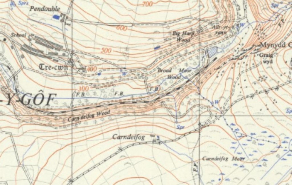
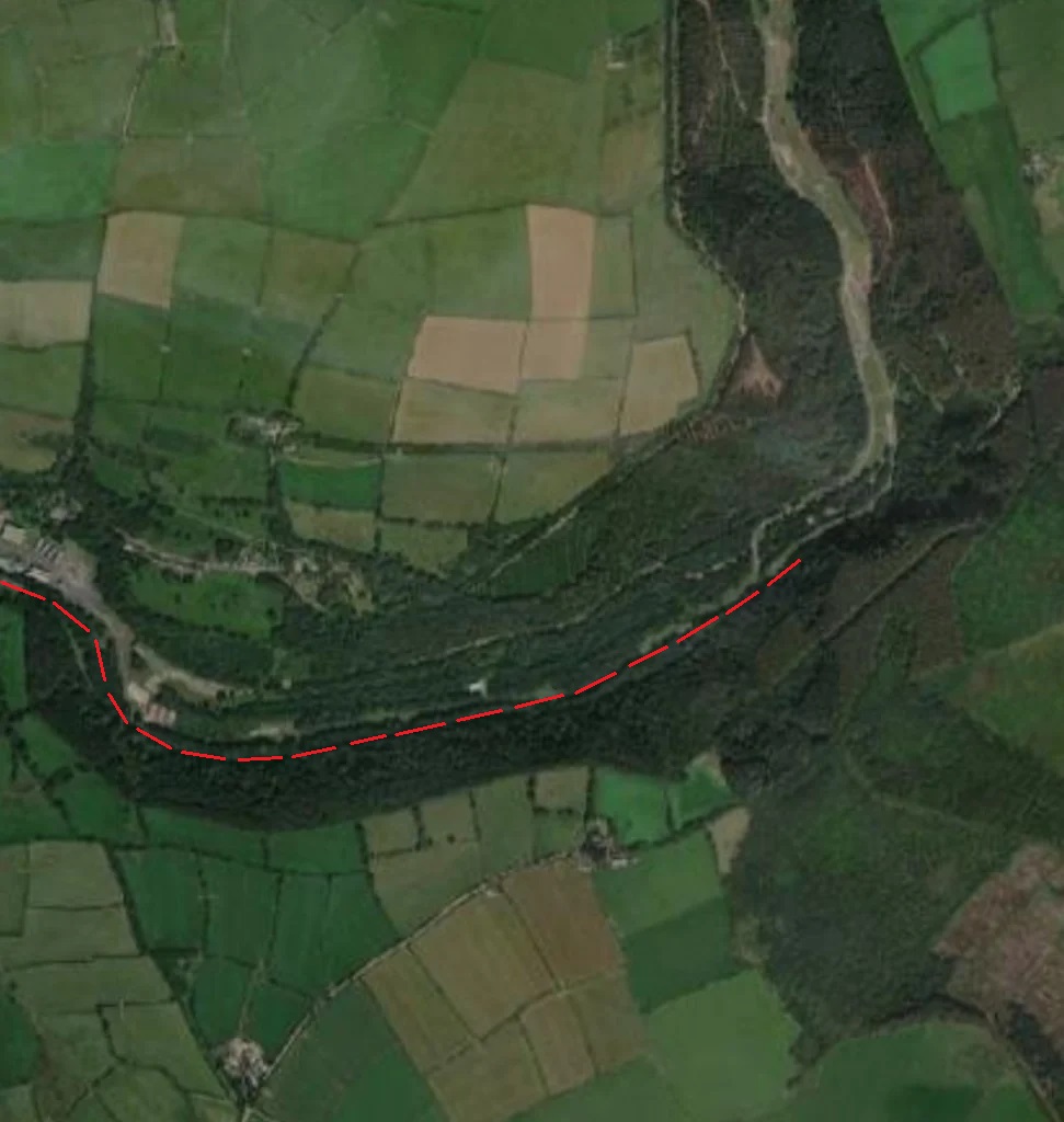
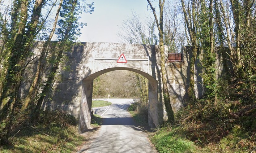
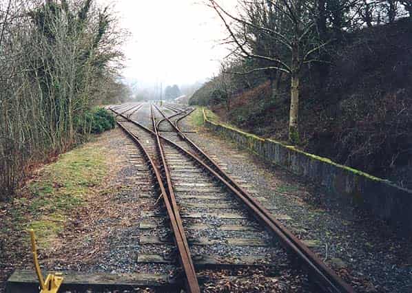
Dashed-red lines show the approximate route of the old standard-gauge line which was lifted in the early 21st century. [82]The remaining length of the Trecwm branch-line as shown on the 1951 1:25,000 Ordnance Survey. [60]The same area as shown in the OS Map above[230]Coflein provides this map of the main site in 2021. Careful inspection will show that the standard-gauge branch-line has been lifted by the date of this Ordnance Survey edition. [61]The 1906 6″ Ordnance Survey shows no sign of either the standard-gauge branch nor the infrastructure that made up RNAD Trecwn. [231]The same area on modern satellite imagery shows much of the infrastructure of the Depot remaining after closure. The standard-gauge sidings remain at the date this image was produced. [231]Just before reaching Trecwm, the line passed under the lane which can be seen at the left side of the satellite image above. The bridge parapets have been extended upwards for safety reasons using galvanised metal fencing. [Google Streetview, October 2021]The concrete bridge carrying the standard-gauge branch-line over a local road just prior to its entry into the Depot. [Google Streetview, March 2022]The same structure viewed from the North. [Google Streetview, October 2021]Google Maps in 2022 still shows the sidings in place in RNAD Trecwn. No doubt this will get updated in due course. [Google Maps, 29th September 2022]The site extends across the join between two OS Maps. This 1948 revision of the 6″ OS Mapping shows the West end of the Depot. The map was published in 1953. [232]At approximately the same scale, the next OS Sheet shows only the standard-gauge line and not the internal narrow-gauge lines. It is shown terminating at the same location as the mapping further above. [233]The fan of standard-gauge sidings just inside the Depot fencing, (c) Dave Mansell, taken in 2003. This image is used with the kind permission of the Subterranea Britannica website. [234]
Three aerial photographs are provided by the Fishguard and Goodwick Local History Society. Posted by Ian Evans, they are used here by kind permission.
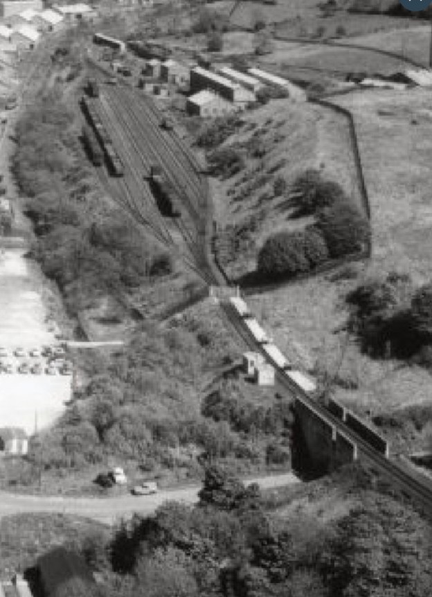
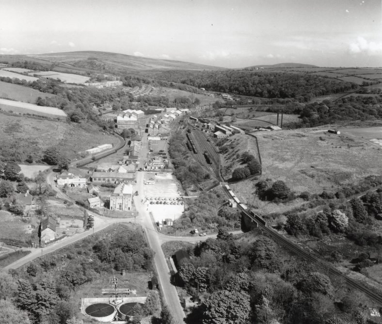
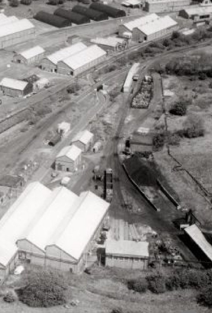
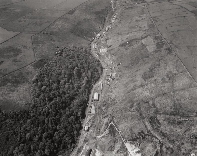
The first one shows the main entrance to the depot at it’s southern end. It can be dated to the mid-1950’s. “At the bottom right of the image can be seen the main railway line into the valley, leading to the railway sidings. The buildings to both sides of the railway sidings included a number of specialist workshops and storage facilities, there were no live explosives handled in this area.” [247]
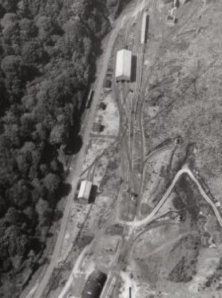
This aerial photograph looks from the West along the valley of the Afon Aer. To the right of centre, the fan of standard-gauge sidings can be made out. An enlarged image taken from this picture follows below. The picture was taken in 1955 and is used with the kind permission of Ian Evans and the Fishguard & Goodwick Local History Society. [247]An enlarged section of the photograph above which shows the bridge which carries the line over a minor road close to the Depot gates, in the bottom-right. The fan of sidings feature prominently towards the top of this extract. The branch beyond the sidings first curves away to the South [247]
The second “shows the workshops and stores buildings in more detail. The building at the bottom right with the tall chimneys was the southern boiler house which supplied steam to most of the buildings seen here. It was in this area that the narrow gauge railway system started, it extended right up the north end of the site.” [247]
Of interest, to me at least, is that when I load Google Earth onto my desktop I automatically get the railway tracks at Trecwn added. I am not sure how that happened, but it is useful for this article. ….
A Google Earth extract with the network of lines in the valley of the Aer shown in black. This is the first length inside the Depot. [Google Earth, 29th September 2022.The remaining length of the Depot in the Aer Valley. [Google Earth, 29th September 2022]
The third of three aerial images from the mid-1950s appears below. It “shows the red area where live explosives were handled and stored, everything from .303 Rifle bullets to 1 Thousand pound bombs were processed here and stored in 58 Magazines built into each side of the valley, If you zoom in you can see a number of the tunnel entrances quite clearly. A lot of the smaller buildings have blast walls surrounding them. The complex extended further north from this photo to the north end Boiler House and security gates.” [247]
The remaining length of the Depot taken from the air looking North along the valley of the Aer. Again, the picture was taken in 1955 and is used with the kind permission of Ian Evans and the Fishguard & Goodwick Local History Society. These images can be found at http://www.hanesabergwaun.org.uk/ [247]These two images are enlarged extracts from the last of the three aerial images above. It is possible to see something of the network of lines which existed in the valley. [247]
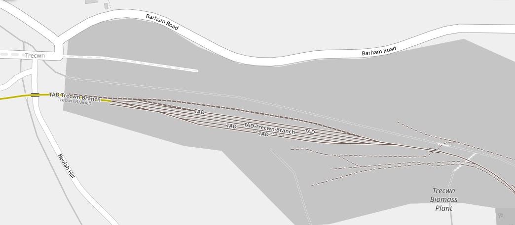
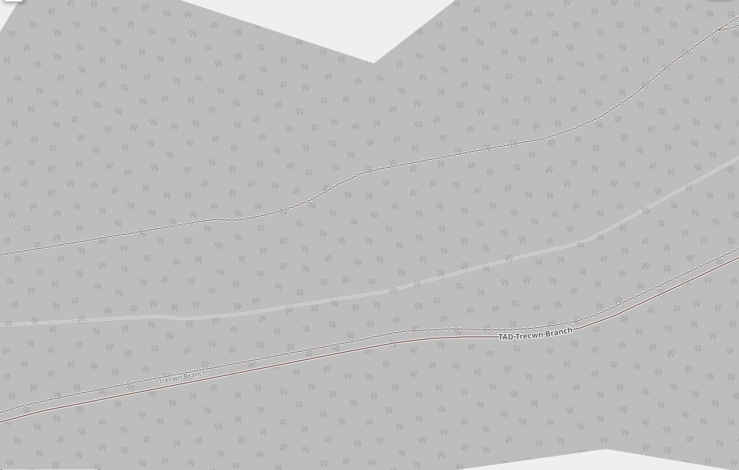
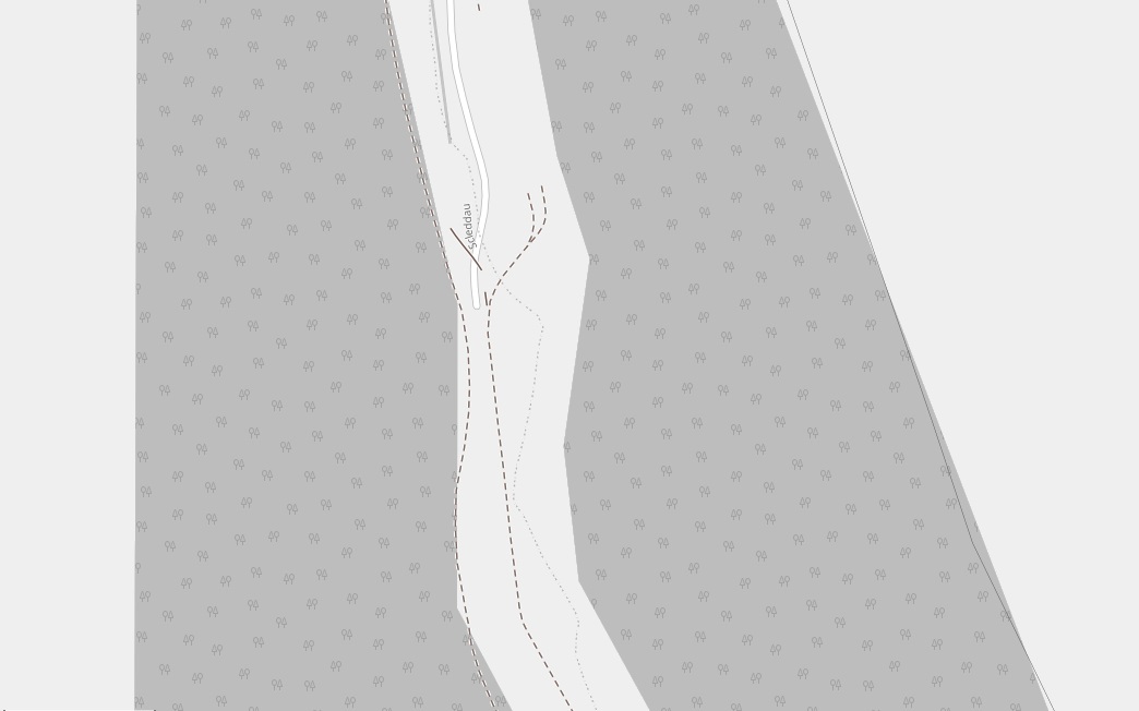
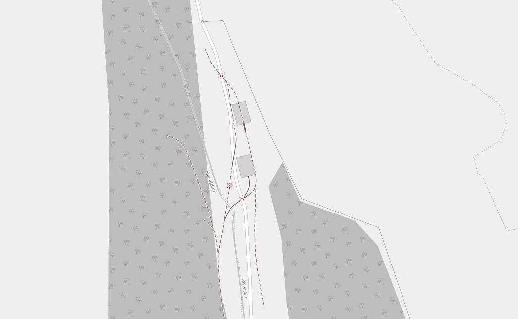
The OpenRailwayMap [235] is also of great help in establishing what railways existed inside the Depot. It is clear that the standard-gauge line extended much further to the Northeast along the valley of the Afon Aer than the Ordnance Survey mapping records.
To complete this section on the Standard-gauge line, I have included a series of screen-dumps from the OpenRailwayMap [235][236]. Having them at this point in the article should hopefully minimise scrolling when we look at the Narrow-Gauge network at the depot. The sequence of the map extracts runs from the Depot gates in the West, closest to the hamlet of Trecwn, eastwards to the point where the valley turns to the North and then follows the valley northwards.
This final image is the key/legend provided by the OpenRailwayMap [235][236] editors. The Trecwn branch as far as the depot gates is shown in yellow above. The standard-gauge lines within the Depot are deemed industrial lines and are therefore shown as thin brown lines. The length of these line inside the Depot is significantly longer that that shown on the Ordnance Survey maps. Abandoned standard gauge lines are shown as thick dashed brown lines (not grey as in the key).
The narrow gauge lines are shown as thin dashed brown lines. It is possible that by the time the mapping was undertaken these had been abandoned and are hence shown dashed. There are a very few lengths of narrow-gauge track shown solid brown.
The extent of the network of these lines is, for me, the most engaging element of this mapping. RNAD Trecwn had a very significant internal narrow-gauge network. …
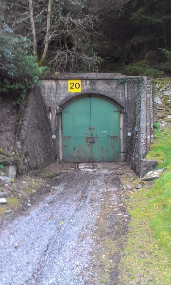
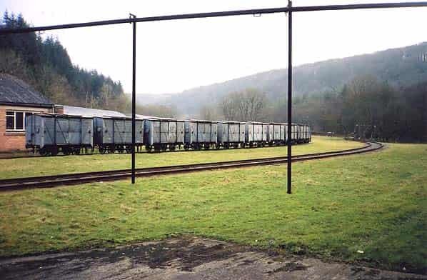
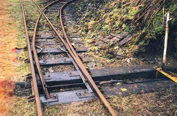
The Narrow Gauge (2ft 6in) Lines – A 2ft 6in (762 mm) gauge network traverses the entire site, with direct access to the 58 cavern storage chambers. All rail infrastructure was built in copper to reduce the risk of sparks. Serviced via its own on-site locomotive shed and works, the line was equipped with a series of specially provided wooden enclosed wagons, with sliding roof covers. This allowed sea mines and other munitions to be directly placed within the wagons from overhead gantries, and transported over the entire site without access via any form of side door, hence enhancing safety. The narrow gauge line therefore became the main method of on-site distribution, with standard gauge rail or road the off site access method. [56]
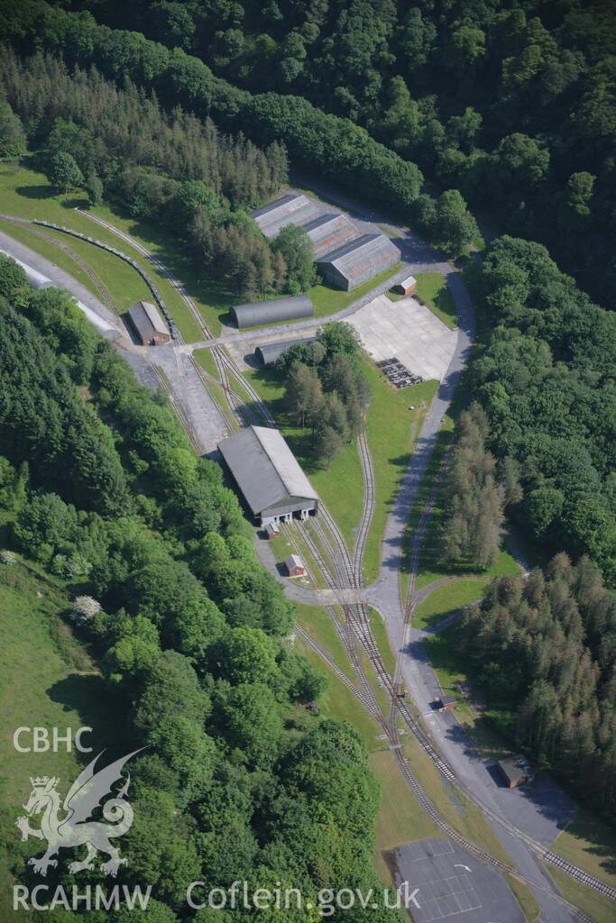
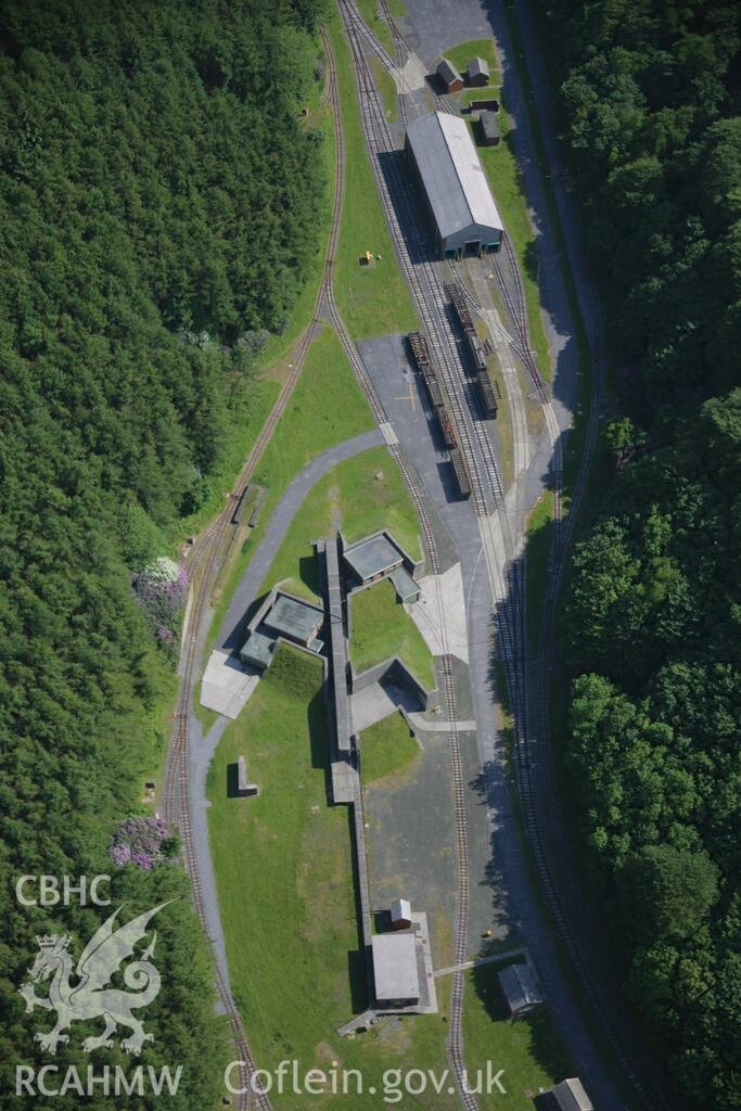
The next few aerial images can be found on the Coflein website and show elements of the narrow-gauge system running along the site. In places the standard-gauge and narrow -gauge sit side-by-side.
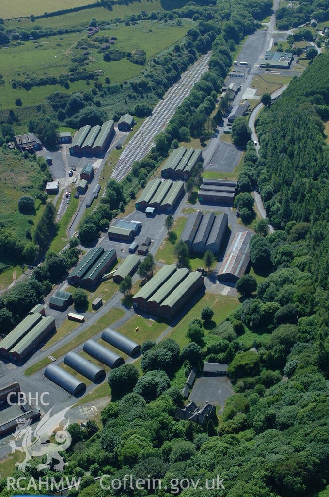
This next aerial image comes from before the narrow-gauge tracks were lifted. The most obvious lines are standard-gauge lines but careful inspection will show the narrow-gauge network as well. This photograph was taken in 2006. [61]Turning through 180° this next aerial image from 2009 comes from the time when large parts of the narrow-gauge system had been lifted but before the narrow-gauge tracks at locations crossing site roads or standard-gauge lines were lifted. Careful inspection will identify a number of such locations. [61]View from the North in 2006 looking down on the upper area of the Depot with both standard-gauge and narrow-gauge lines visible. [61]Also taken in 2006 from the North, this view shows a number of the storage bunkers on site and the rail system. [61]Again taken in 2006, this photograph looks from the Southeast showing more of the bunkers in the northern length of the Depot. [61]
In 2003, David Mansell, writing about the site commented: “About a mile into the site the narrow gauge railway facilities commence with maintenance sheds and a covered transfer building. There are a total of 58 storage chambers, each extending into the hillside for 200 feet, arranged in a herringbone formation along both sides of the valley. Each one has alarmed steel doors with its own siding off the narrow gauge railway.” [234] … His opinion at the time, was that RNAD Trecwn was “a railway enthusiasts dream with both standard and narrow (2ft 6in) gauge lines. The depot has its own branch off the Fishguard to Carmarthen line and after a small platform area outside the depot for staff the line enters the site via lockable steel gates into the main marshalling yard where the line splits into 8 parallel loops. The standard gauge line then travels the entire length of the valley alongside the narrow-gauge line which has points for the siding to each storage chamber.” [234] …
The narrow gauge rolling stock then consisted of the “well known ‘Trecwn’ wooden wagons with sliding roofs to enable mines to be lowered in and flatbed trucks for other munitions. Some of the stock can now be seen on the Welsh Highland and [Welshpool and] Llanfair light railways.” [234]
At the time Dave Mansell was writing, there was still a substantial amount on site. Locomotives included small diesel shunters and battery units; some derelict examples of which were still on the site in 2003. Points on both gauges were manually operated and still well greased. [234]
The next few photographs were all taken early in 2003 by Dave Mansell and are shared with his kind permission and that of Subterranea Britannica…..
Locomotives – a series of narrow-gauge locomotives were employed at the site. These are surviving examples:
Ruston & Hornsby 187069 – was a Class 25/30hp locomotive with a Ruston 3VSO engine and weighing 3.25 tons. It left the works on 28th October 1937. “It was one of forty of that type working on the Nuttall-Pauling Consortium contract to build the … Depot at Trecwn. … Construction was complete by 1941 but this locomotive was evidently still in the West of Wales in 1950, because a spares order was placed by Pauling on 26th May 1950 to be sent to Geo Bros Ltd., East Burrows Yard, Swansea, which may have been repairing it. In 1951 it was noted at Pauling’s Park Royal plant depot, Middlesex, numbered P250 in the Pauling list. It was later sold or scrapped at an unknown date. [229: p1-2]
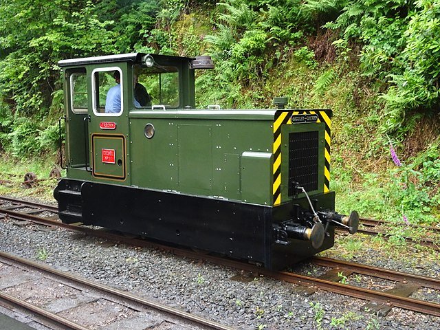
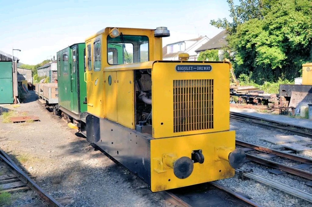
Baguley-Drewry Locomotives – Baguley-Drewry of Burton-on-Trent built a number of locomotives for this narrow gauge network.
The Talyllyn railway purchased two of Trecwn’s narrow-gauge locomotives …. Diesel No.11 “Trecwn” & No.12 “St Cadfan” were purchased by Talyllyn volunteers from RNAD Trecwn in 2008. The names were decided by ballot in 2014 by the group that originally purchased the locomotives for the Talyllyn. Both Locomotives were re-gauged from 2ft 6in to the Talyllyn’s 2ft 3in Gauge. Talyllyn members also purchased over a mile of track from RNAD Trecwn complete with rail, sleepers, spikes and fishplates in June 2008. [251]
The Talyllyn’s Facebook Page provided photographs of these locomotives. These two images were included. [251]
32. D S M Barrie, revised Peter Baughan; A Regional History of the Railways of Great Britain: volume 12: South Wales; David St John Thomas, Nairn, 1994.
36. Wing Commander Ken McKay; A Vision of Greatness: The History of Milford 1790-1990; Brace Harvatt Associates, 1989.
236. OpenRailwayMap (previously called “Bahnkarte”) is a detailed online map of the world’s railway infrastructure, built on OpenStreetMap data. It has been available since mid-2013 at openrailwaymap.org. This project was founded in December 2011 in order to create a world-wide, open, up-to-date and detailed map of the railway network, based on OpenStreetMap. The domain was registered on April 27th, 2013 and the corresponding website was launched in mid 2013. Since then it has received constant improvement. In February 2014 the project moved to a new server. In April 2014 a dedicated map for mobile phones was launched. [237]
The OpenRailwayMap includes all rail-mounted and automotive vehicles, e.g. railways, subways, trams, miniature railways and funiculars. The map does not include aerialways, monorails, and maglevs. The name OpenRailwayMap mostly refers to the online map, but the project also aims to support railroad-related data in OpenStreetMap. By developing a consistent data model, providing a mailing list for discussions, developing editor plugins, etc. the collection of these data is boosted and the data are made usable for other applications and developers. [237]
241. This statement needs a minot clarification. The Trecwn Branch used to leave the line between Fishguard and Clynderwen just South of where that line diverged from the route from Fishguard tthrough Clarbeston Road. The North Pembrokeshire line was lost many years before the Trecwn branch closed. The tracks visible in the image above led only to Trecwn.
This plan appears at the head of the article on the Disused Stations website about the Fishguard to Clynderwen route – a.k.a the North Pembroke shire and Fishguard Railway. it shows the Trecwn branch leaving this railway just South if its junction with the line through Clarbeston Road. [242]


