
A holiday in West Wales in the early Autumn of 2022 led to a little research on the railways in the area.
Looking furthest West, we start with the industrial railways of Pembrokeshire. …. Before 2022, I was unaware of the coalfield that existed in Pembrokeshire which was served by a series of short railways and tramroads/tramways.
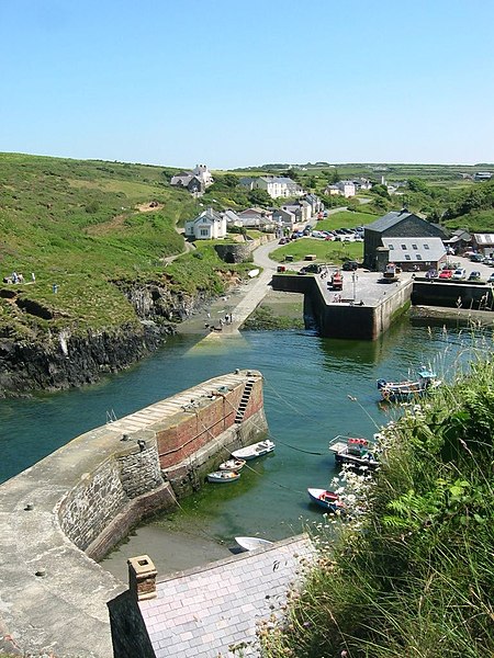
The featured image above shows Porthgain harbour in 2005. The pier was the terminus of the Porthgain to Abereiddi railway.
Before the Railways
Elsewhere in the UK, a usual pattern of development was for river traffic to be supplemented by tramroads and canals which then, often when traffic warranted it, were replaced by railways. It did not exactly work out like that in Pembrokeshire. … We start with a quick look at the history of industrial transport of the County before the railways. …
River and Estuary Traffic in Pembrokeshire.
Natural waterways were often used as main trade routes and various form of vessel were used sometimes with sails but usually (even then) with bow-haulers or horse-power on the river banks.
Historically, the Daugleddau Estuary was important in the early Industrial Revolution, shipping anthracite from Llangwm, Landshipping and Crescelly, and limestone from Lawrenny and West Williamston. [20]
Haverfordwest was at the tidal limit of the Western Cleddau river.It was the first bridging point and had its own port. … There is evidence of a quay in Haverfordwest as early as 1690. “Haverfordwest was the official shipping point for textiles, hides and wool from across this region. Ships departed for ports around the British Isles before the growing railway network replaced coastal shipping. In the early 1830s, Haverfordwest was dispatching £100,000 worth of goods a year – mainly butter and corn – to Liverpool and London.” [2]
It seems that the Eastern Cleddau was also used as an inland waterway. Timber was cut on the Slebech estate and formed into rafts which were then floated on the receding tide down to a point just below the confluence of the Eastern and Western Cleddau rivers. The rising tide was then used to carry these rafts upstream on the Western Cleddau to Hook or one of a number of small quays where the rafts were dismantled and the timber then used for pit props in a number of mines. [1: p121]
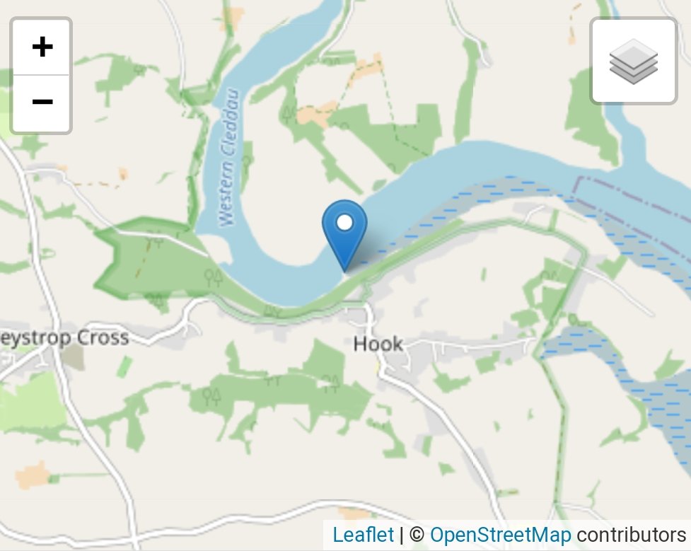
Milford Haven Waterway is a drowned valley which was flooded at the end of the last ice age.[3] The Daugleddau estuary winds west to the sea. As one of the deepest natural harbours in the world, it is a busy shipping channel, trafficked by ferries from Pembroke Dock to Ireland, oil tankers and pleasure craft. Admiral Horatio Nelson, visiting the haven with the Hamiltons, described it as the next best natural harbour to Trincomalee in Ceylon (today’s Sri Lanka ) and “the finest port in Christendom”. [4]
Milford Haven was at one time a staging point on sea journeys to Ireland, and was used as a shelter by Vikings. From those days on, it was a port of vital significance which provided safe shelter to many a vessel. It was seen as being if strategic importance from at least the 15th century. [5]
Roads and Tracks
“Late 18th and early 19th century travellers in South Wales … frequently commented on the appalling condition of the roads. This was at a time when the condition of roads across England and Wales was generally improving as a result of turnpike trusts creating new roads and upgrading existing roads. Prior to the creation of the turnpike road system, most roads, lanes and tracks linked villages and small towns; long distance road travel was rare, and virtually impossible for wheeled vehicles. Some improvement was carried out by large landowners, but it was not until the creation of turnpike trusts that a co-ordinated road network came into being. By 1750 about 150 trusts had been established in England and Wales, rising to
almost 700 by 1800 and over a 1000 in 1825.” [21]
“Some of the early turnpike routes in south-west Wales were improvements to existing roads, but by the end of the 18th century new routes were being created and the older roads (or sections of them) either became downgraded to a local
lane or track, or were abandoned.” [21]
The narrowness of local roads in Pembrokeshire meant that carts had to be long and thin making them difficult to manage. [1: p121] Hiring of horses appears to have been excessively expensive because of their scarcity. [1: p122] As in much of the rural areas of England and Wales, the condition of roads in the County of Pembrokeshire was appalling. “Outside the towns few if any had any kind of prepared surface, and the unfortunate traveller had to contend with potholes and deep mud in winter, and with bone jarring ruts and choking dust in summer.” [1: p123] Very high tolls were extracted by various turnpike trusts. Direct land routes were often not available and as a result some collieries were totally dependent on shipping. [1: p124]
Canals in Pembrokeshire?
Apparently it was as late as 1792 that the first attempt was made to build a canal to move coal in Pembrokeshire.
Canals elsewhere in Wales appeared somewhat earlier. The first, in 1769, was in the Gwendraeth Valley in Carmarthenshire. It was soon followed by others.
M.R. Connop-Price tells us, however, that in 1792, “Lord Milford endeavoured to construct a canal between his pits at Merrixton Bottom(Stepaside) and his shipping place on the beach at Wiseman’s Bridge, a distance of just over a mile.” [1: p120]
It appears that the Milford canal was designed only to accommodate tub-boats and was never completed. Industrial archaeologists reached this conclusion in the 1960s as they studied what remnants of the proposed canal remained. By the 1990s most of the evidence of the proposed canal had disappeared. [1: p 121]
It seems that Pembrokeshire had no one willing to invest in a canal after the attempt was made by Lord Mitford! [1: p121]
Tramways/Tramroads (which preceded the use of railways)
It seems that the pioneer of the first canal in Wales (in the Gwendraeth Valley, East of the Pembrokeshire county boundary), Thomas Kymer, owned land to the South side of the village of Nolton. It is thought that he constructed a wooden tramway of about 0.75 mile in length from pits on his estate to Nolton Haven. As he moved from Pembrokeshire to Carmarthenshire before 1770, the tramway would have had to be built before that date. [1: p125][6]. We cannot be sure that the tramway was built. There is greater certainty over a, probably short-lived tramway connecting pits at Folkston and Simpson on the estate of R.P. Laugharne to Nolton Haven. [1: p125][7]

Connop-Price tells us that “the earliest Pembrokeshire tramway which can be dated confidently was constructed at Landshipping, on the estate of the Owens of Orielton. In 1800, Colonel Colby, as a trustee of the estate, initiated fresh investment in the Landshipping colliery, the works including the building if a new embankment and bridge across Landshipping Pill and a new quay on the South side of the Pill.” [1: p125][8] “Ten years later, in 1810 and 1811, tramways were added to these structures, linking them with the main pits comprising the Landshipping colliery.” [1: p125][9]
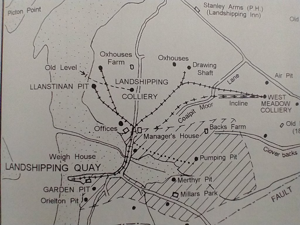
It seems that, “in its original form this tramway was a plateway, that is to say that it ran on L-shaped cast iron plates laid on stone blocks. … It is thought that these plateways went out of use either before or at the time of the Garden Pit accident at Landshipping in 1844. When the coal industry in this district received some new investment in the 1860s, it is believed that the tramway then in use had edge rails. Unfortunately this reconstructed tramway seems to have been abandoned after a halt to mining activity in 1867.” [1: p125]
An inspection of the coal works at Freystrop and Little Milford was undertaken in 1805. A recommendation in the inspection report was that a Tramroad should be built between the Cleddau at Little Milford Quay and the coal workings at Freystrop. If built when recommended it will have been a plateway but any delay may have seen it constructed in edge rails. [1: p125] By 1850, the Tramroad was an edge railway, “and it had been extended by the provision of two or three short branches to nearby pits, the most significant serving coal pits at Maddox Moor. … The last reference to it appears … in 1882.” [1: p126]
This Tramroad is recorded by Coflein. Their record notes it as “The track of a tramway shown only on the 1837 Tithe map now a straight path through the woods. The tramway connected part of the extensive Freystrop colliery to the south with the quay at Little Milford. The tramway now only survives as a kind of cutting through the woods and had gone by the time of the O.S. survey later in the 19th century. However it is a very interesting survivor in however a slight a form since it represents an early phase of mining in the area and a very early tramway.” [10]

Dyfed Archaeology notes that “by 1839, a tramway led down from Freystrop to the quays, and an incline from Maddox Moor to Little Milford had been established by 1851. However, the decline in the coal mining industry in the early 20th century followed by the closure of the Pembrokeshire collieries in 1947, resulted in Little Milford reverting back to a minor shipping/landing place.” [11] This suggests that there was a period of about 12 years when no inclined plane was available for access from the tramroad from Freystrop to the quay at Little Milford. A sinuous old cart road is shown on Connop-Price’s drawing. This may well have been an original steep alignment of the Tramroad which was proven to be too steep for regular traffic and which was replaced by the inclined plane.
Connop-Price highlight initiatives further to the East, to develop a tramway in the Saundersfoot area in 1806 and again in 1825. The first appears to have been an abortive attempt, the second was probably short-lived as on “a map of the Hean Castle estate dated 1845, the line was then considered an ‘old tramway’, thus implying that it had a very short career.” [1: p126] Connop-Price says that “the route of the tramway between Coppet Hall and St. Issell’s church survives as a footpath known as Black Walk, and the tramway itself is sometimes described as ‘the Black Walk Tramway’.” [1: p126]
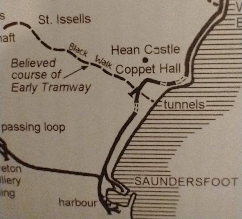
The Black Walk Tramway is referred to in a publication on the Visit Saundersfoot Bay website. [12] The Saundersfoot Railway will be considered in a future article.
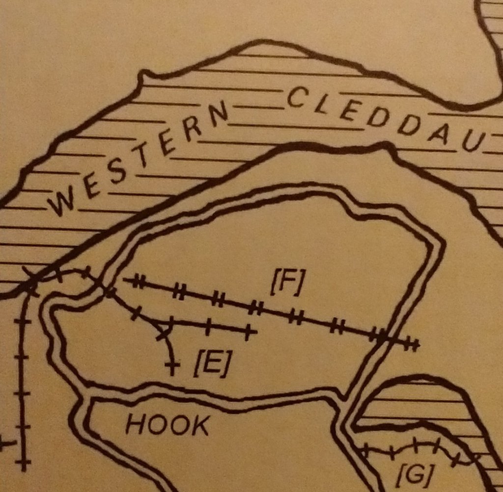
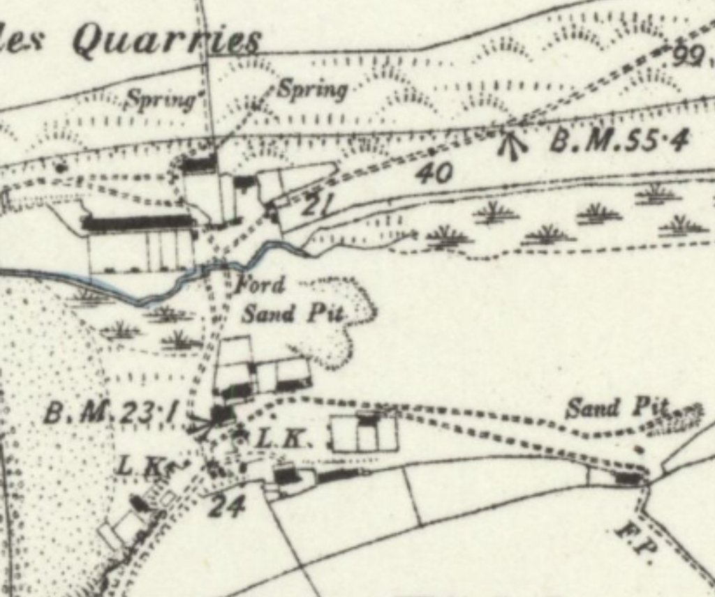
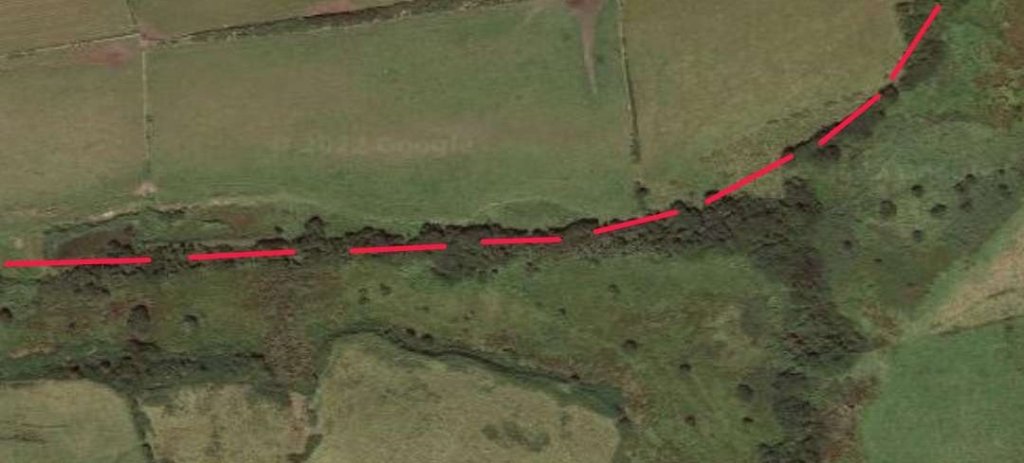
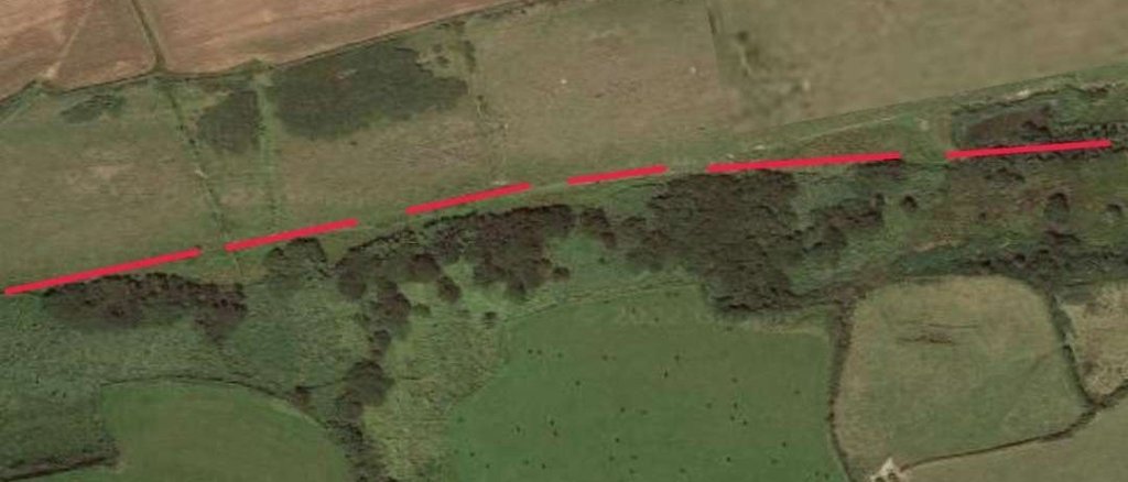
At Hook on the Western Cleddau authorisation was given, early in 1837, for the construction of a tramroad on land of no greater width than 15ft between Hook Colliery and the River which seems to have been the first part of a small network of tramways. [13] Connop-Price tells that this tramway appears initially to have been “about half-a-mile long from the Pill to the Commons Pit, sunk in 1840, with extensions onwards to the Slide Pit, Winding Pit and the Aurora Pit and the Green Pit. Before long it was extended as far as the escarpment overlooking the Western Cleddau above Hook Quay.” [1: p126,128] Connop-Price also notes that “the alignments of some of these tramways can be traced in the fields at West Hook.” [1: p143] I have been unsuccessful in identifying these old routes on Google Earth’s satellite images but one length is shown on the early Ordnance Survey of the area. This is shown in the second image below.
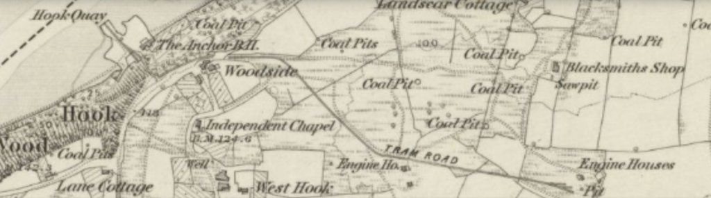
Hook Quay is noted as an Ancient Monument (Cadw Legacy ID: PE529). The Ancient Monuments website says that it is “an important element of the eighteenth century coal industry in Pembrokeshire … located between Hook Bight and Hook Reach in the inter-tidal zone on the S bank of the Western Cleddau. The stone built quay is mostly intact and located within the garden of a residential house. Caesar Mathias Junior of Hook constructed the quay in 1791 to serve Hook Colliery. Shallow draught barges transported anthracite from Hook Quay downstream to larger ports such as Milford Haven. The quay is visible as a substantial masonry wall with a wooden framework to the N and a raised area of made-up ground to the S. The quay measures c. 3m tall. The combined stone and wooden structure measures c. 40m N-S by 40m E-W.” [14] No mention is made on the website of the 19th century tramways associated with the Quay.

The tramways are mentioned in passing in “The Secret Waterway” published by PLANED (Pembrokeshire Local Action Network for Enterprise and Development) in 2008: “The area was once the centre of a thriving coal industry. Anthracite coal was mined from the fourteenth century and was exported as far as Spain. Legend relates that the Spanish sailors bartered daffodil bulbs for coal. The early workings were shallow
shafts, four to six metres deep, but, by the 19th century, deep mines such as the Old Aurora and Amen pits had opened. A tramway was built to carry coal to Hook Quay for shipment. By
1931, 35,000 tons of coal was exported by rail and water. Thereafter production declined and following flood damage in 1948, the last of the pits closed.” [16]
Worthy of a short note here is a further tramway in the vicinity of Hook village which served a colliery erected/incorporated in 1858. The tramway was about 0.5 mile long running along the South side of Hook/Sprinkle Pill. This tramway was first used in 1858 and closed in 1866. [1: p128][27][28]
One final tramway associated with Hook Quay is worth noting. In 1888, or thereabouts, West Park Colliery, which was due South of the Quay was linked by a 770 yard tramway. Connop-Price tells us that “there were five bridges over or under this line largely built of wood, and the final 300 yards comprised a steep rope-worked incline dropping down to the quay.” [1: p128] This line appears immediately to the West of Hook village on the extract above from the plan in Connop-Price’s thesis. [1: p129 Fig. 36]
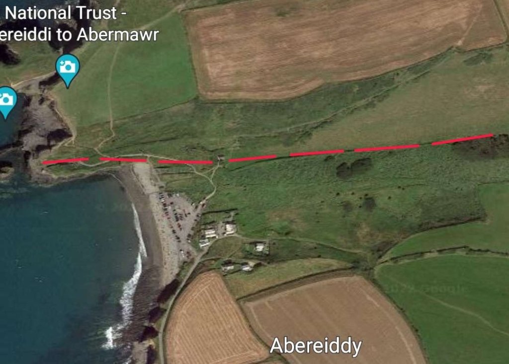
The Porthgain To Abereiddi Tramway (1880s) was highlighted by Coflein in a report dated 18th November 2014. It connected a “quarry pit at Abereiddi (now a tidal pool) with the hoppers above the harbour at Porthgain. The section of the tramway at the West nearest the quarry pit connects with the processing works and lift (NPRN 420607) above the pit. Here there are the remains of sleeper beams each about 1.2m long. the trackway itself being about 2.5m wide. Further East the line continues to a water tank (NGR SM8115 3262) where it veers SE and splits into two branches (possibly three) to terminate above the hoppers at Porthgain. There are no surviving rails. Trucks were initially pulled by horses but later by steam locomotives.” [23] The tramway appears on the 1887 6″ Ordnance Survey published in 1888. The tramway was active from the 1880s to 1931. [26] The tramway was 3.6km (2.2 miles) long. Its rails were 91cm (3ft) apart. From 1909, steam locomotives shunted wagons at the harbour, where stone also arrived from other quarries. The Abereiddi tramway remained horse-powered. [29] There were a series of four different small engines used at the port. [26]
It’s route is shown in the series of extracts from the Ordnance Survey maps below. …


Much of the alignment shown in the map extracts above can be followed on satellite images from Google Earth.

In the next article in this series we will survey the mainline railways of Pembrokeshire.
References
1. M.R. Connop-Price; Pembrokeshire: the Forgotten Coalfield; Landmark Publishing, Ashbourne, Derbyshire, 2004
2. https://historypoints.org/index.php?page=old-quay-haverfordwest, accessed on 5th September 2022.
3. Milford Haven Waterway – Countryside Council for Wales. Archived from the original on 5 April 2010, https://www.webarchive.org.uk/wayback/archive/20100405015700/http://www.ccw.gov.uk/landscape–wildlife/protecting-our-landscape/historic-landscapes-1/historic-landscapes-map/milford-haven-waterway.aspx, accessed on 5th September 2022.
4. Wing Commander Ken McKay; A Vision of Greatness: The History of Milford 1790–1990; Brace Harvatt Associates, Haverfordwest, Dyfed, 1989.
5. https://en.m.wikipedia.org/wiki/History_of_Milford_Haven, accessed on 5th September 2022.
6. Thomas Kymer is discussed in detail in Raymond E. Bowen; The Burry Port and Gwendraeth Valley Railway and its Antecedent Canals, Volume 1 (No. 116A); Oakwood Press, Stenlake Publishing, Catrine, 2001.
7. National Library of Wales, Francis Green MS. Vol. 6, 185.
8. National Library of Wales, Owen & Colby, MS. 2052.
9. National Library of Wales, Owen & Colby, MS. 2073.
10. https://coflein.gov.uk/en/site/43, accessed on 7th September 2022.
11. https://dyfedarchaeology.org.uk/HLC/milford/area/325.htm, accessed on 7th September 2022.
12. http://www.visitsaundersfootbay.com/uploads/files/Saundersfoot%20walk%20web.pdf
13. Pembrokeshire Record Office, D/POW/H/66.
14. https://ancientmonuments.uk/129984-hook-quay-hook/map#.YxpBTR7TXTg, accessed on 8th September 2022.
15. https://www.walesonline.co.uk/lifestyle/welsh-homes/take-aerial-tour-river-views-11454008.amp, accessed on 8th September 2022.
16. http://www.echoeswales.cymru/wp-content/uploads/2020/06/secret-waterway-engsmall.pdf, accessed on 8th September 2022.
17. https://maps.nls.uk/view/102353015, accessed on 8th September 2022.
18. Pembrokeshire Herald, 20th August 1903.
19. http://www.ropeways.co.uk/uk/rw_ukgaz.htm, accessed on 8th September 2022.
20. https://en.m.wikipedia.org/wiki/River_Cleddau, accessed on 9th September 2022.
21. https://www.dyfedarchaeology.org.uk/wp/wp-content/uploads/turnpike2016.pdf
22. The image shown is a compilation from two OS maps which have been electronically spliced together. The mill stream and therefore the old tramway route appear on the more northerly of the two maps: https://maps.nls.uk/view/102188514, accessed on 10th September 2022.
23. https://coflein.gov.uk/en/site/400060, accessed on 10th September 2022.
24. https://maps.nls.uk/view/102188094, accessed on 10th September 2022.
25. https://maps.nls.uk/view/102188304, accessed on 10th September 2022.
26. https://en.m.wikipedia.org/wiki/Porthgain_Railway, accessed on 10th September 2022.
27. Public Record Office, BT/31/356/1299.
28. Connop-Price states that”the year of closure may be discerned from a photocopy of private correspondence in [his] possession indicating that on closure the manager of Nash & Sprinkle applied for a similar post with a new company in Landshipping.” [1: p 143]
29. https://historypoints.org/index.php?page=site-of-quarry-tramway-abereiddy, accessed on 10th September 2022.

Pingback: Railways in West Wales Part 1B – Pembrokeshire Mines, Quarries and Their Railways – the Mainline Railways | Roger Farnworth
Pingback: Railways in West Wales Part 1C – Pembrokeshire Industrial Railways – Section B – The Saundersfoot Railway (First Part) | Roger Farnworth
Pingback: Railways in West Wales Part 1C – Pembrokeshire Industrial Railways – Section C – RNAD Trecwn | Roger Farnworth
Pingback: Porthgain Clifftop Tramway | Roger Farnworth
Rev. Farnworth, do you happen to know if Martin Connop Price is still alive? I’m writing about the 1844 Garden Pit disaster at the moment [https://docs.google.com/document/d/1FkOvAnEPjm2EQW92RjVzZjQqfjg_HOoQunor3FC3dAg/edit?usp=sharing] and the Rev’d Connop Price’s 2004 book, now sadly rare, appears to be the only thorough study of the coalfield in modern times.
I think he was a few years ago but not sure now.
Rev. Farnworth, do you happen to know if the Rev’s Martin Connop Price is still alive? A long shot, I know. I’ve recently been writing about the Garden Pit disaster and his 2004 book — now sadly rare, and correspondingly expensive, even second-hand — seems to be about the only modern scholarship about the Pembrokeshire industry. Thanks, Howell Harris
https://docs.google.com/document/d/1FkOvAnEPjm2EQW92RjVzZjQqfjg_HOoQunor3FC3dAg/edit?usp=sharing