

On the road between Purton and Etloe on the Northwest side of the Severn Estuary there is a railway viaduct. Seemingly it sits remote from any former railway. Although you might just be forgiven for thinking that it is a remnant of the Forest of Dean Central Railway, or even associated with the Severn & Wye Railway which ran close to, but to the South of, the hamlet of Purton.


It is, in fact, the main remnant of a planned railway/tramroad – the Purton Steam Carriage Road! It can be seen on the map extract below which shows the viaduct just to the North of the hamlet.

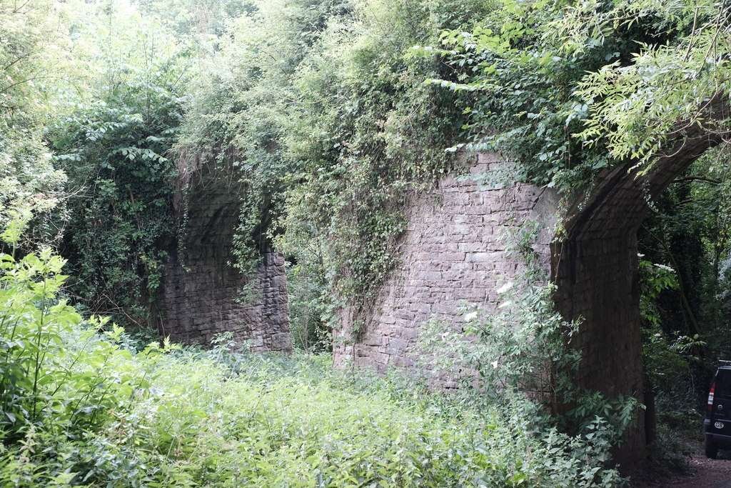
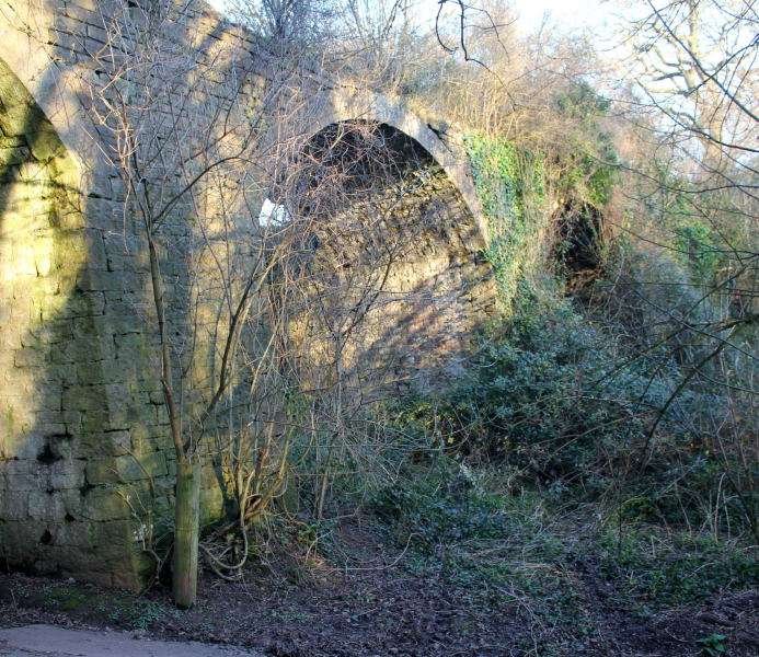
The viaduct was built, circa. 1832, of red sandstone rubble with dressed voussoirs. It has 3 arches of diminishing heights, its main pier is wedge shaped, so that the viaduct is slightly angled. The tallest arch spans the road. The centre arch is damaged on the NE side. Its Southeast wall continues as retaining wall for some distance. Part of the parapet survives at the north west end.
The viaduct is of considerable historical and industrial archaeological interest: the Purton Steam Carriage Road was planned in 1830, just a few years after the Stockton and Darlington Railway first ran in 1825.
Sadly, it was never to carry the goods it was intended for, but it seems to have had considerable effect on local politics at the time, and on later railway enterprises in the area.
“The finance was to come from a prominent local Iron-master, Charles Mathias of Lamphey Court, Pembrokeshire. The viaduct is the most tangible surviving evidence for an industrial scheme which would have involved the first crossing of the Severn on a moveable bridge.” [1]

The Purton Steam Carriage Road Company predated the Forest of Dean Central Railway and intended to build a line, 8 miles or so long, from a purpose-built dock at Purton Pill to the then-new Foxes Bridge Colliery in the Forest of Dean.
A scheme drafted earlier in the century was revived in 1830 and supported by a number of Forest industrialists. As we have already noted, “The promoter of the Parliamentary Bill, presented to Parliament in 1832, was one Charles Mathias, who was so confident of the Bill’s success that he purchased the required land and began construction of the line. Unfortunately, the Bill met strong opposition from the Commissioners of Woods, failed to make its second reading and was withdrawn. Mathias’ premature and misplaced enthusiasm had led to the construction of various bits of railway infrastructure.” [3]
The structures completed included:
- All or part of Nibley Hill Tunnel near Blakeney (the portals are each marked as “old quarry” on the 1892-1914 OS 25″ map);
- A cutting here and there; and
- Purton Viaduct.

Purton Viaduct is Grade II Listed by Historic England. It is recognised as being of “considerable historical and industrial archaeological interest”, but is suffering from the vegetation which has almost hidden it from view in places! [3]
The viaduct is noted in Neil Parkhouse’s, “Forest of Dean Lines and the Severn Bridge” which is the second volume in Lightmoor Press’, “British Railway History in Colour” series. [6]

North of the Viaduct, the line of the Purton Steam Carriage Road can be followed on older maps, as the map extract below shows.


Nibley Hill Tunnel would have been 600 yards in length and would have taken the Purton Steam Carriage Road into the Forest of Dean close to the village of Blakeney.
The Purton Steam Carriage Road was one of two early proposed Tramroads in the Forest of Dean which were close to the line of what became the Forest of Dean Central Railway.
To the North was the proposed Moseley Green and Tilting Mill Tramroad which was intended to link the valley of Blackpool Brook with the outside world by connecting mines in the Moseley Green area with the Bullo Pull Tramroad. It was not pursued. Instead, in 1832, the Purton Steam Carriage Road was devised to access the Blackpool Brook valley. [13]
Its route North of Nibley Hill Tunnel is difficult to identify on the Ordnance Survey mapping of the late-19th and early-20th centuries.
References
- https://historicengland.org.uk/images-books/photos/item/IOE01/06871/35, accessed on 9th September 2023.
- https://www.geograph.org.uk/photo/6503314, accessed on 6th September 2023.
- https://www.geograph.org.uk/photo/6503290, accessed on 6th September 2023.
- https://www.geograph.org.uk/photo/6503302, accessed on 6th September 2023.
- https://www.geograph.org.uk/photo/1284797, accessed on 6th September 2023.
- The National Archive holds records associated with this proposed line which can be accessed at Kew. The relevant details can be found on the following links: https://discovery.nationalarchives.gov.uk/details/r/C7435267, accessed on 17th September 2021. https://discovery.nationalarchives.gov.uk/details/r/C7435264, accessed on 17th September 2021.
- Further details are available on Grace’s Guide, https://www.gracesguide.co.uk/Purton_Steam_Carriage_Road, accessed on 17th September 2021.
- https://www.gracesguide.co.uk/File:JD_Purton_2016_01.jpg, accessed on 17th September 2021.
- https://en.wikipedia.org/w/index.php?curid=22482341#/media/File:The_Severn_Bridge_Sharpness_England.jpg, accessed on 9th September 2023.
- https://maps.nls.uk/view/109727260, accessed on 9th September 2023.
- https://maps.nls.uk/view/109727257, accessed on 9th September 2023.
- https://maps.nls.uk/view/109726411, accessed on 9th September 2023.
- https://booksrus.me.uk/gn/page%2079.html, accessed on 9th September 2023.
- https://maps.nls.uk/geo/explore/#zoom=15.7&lat=51.75242&lon=-2.48792&layers=168&b=1, accessed on 9th September 2023.
