Monthly Archives: Jan 2021

The Micklehurst Loop – Part 1

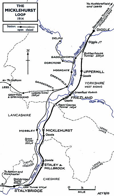
I am indebted to Alan Young for a number of the images in this and the following articles about the Micklehurst Loop. This is his drawing of the Loop which appears at the head of his article about the Loop on the ‘Disused Stations‘ website. It is used with his kind permission, (c) Alan Young. [7]

During January 2021, my wife and I walked the majority of the length of the Micklehurst Loop from Stalybridge to Diggle. This was the goods relieving line for the main Stalybridge to Huddersfield railway line. It had been hoped to alleviate congestion by making the mainline into a 4-track railway but the geography mitigated against this and a route on the other side of the Tame Valley was chosen instead.

The maps used in this sequence of articles are predominantly 25″ OS Maps from 1896 through to 1922 and have been sourced from the National Library of Scotland. [1] There are a number of websites which focus on the Loop which are excellent. The sites concerned are noted immediately below and the relevant link can be found in the references section of this page or by clicking on the highlighted text here:

  1. The most detailed treatment of the line and its stations can be found on the Disused Stations – Site Records website. The particular pages on that site which cover the Loop were provided by Alan Young. One page covers the route and pages covering each of the stations can be accessed from that page. [7]
  2. Particularly good for old photographs of the Loop is the Table 38 webpage about the railway. [12]
  3. 28DL Urban Exploration has pages about Stalybridge New Tunnel under Cocker Hill [19] and about Hartshead Power Station. [20]

Part 1 – Stalybridge to Staley & Millbrook Station and Goods Yard

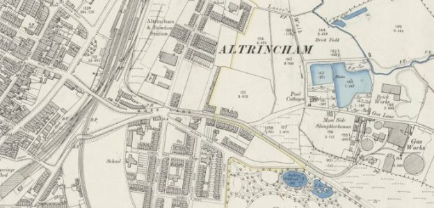
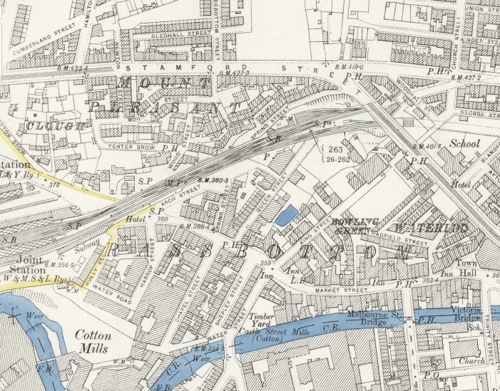
This first map extract shows the Western end of the Micklehurst Loop. It left the mainline at Stalybridge Station which can be seen on the left side of the extract. Both the mainline and the loop entered tunnels under Stamford Street, Stalybridge. [1]
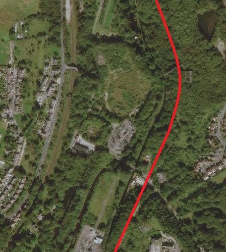
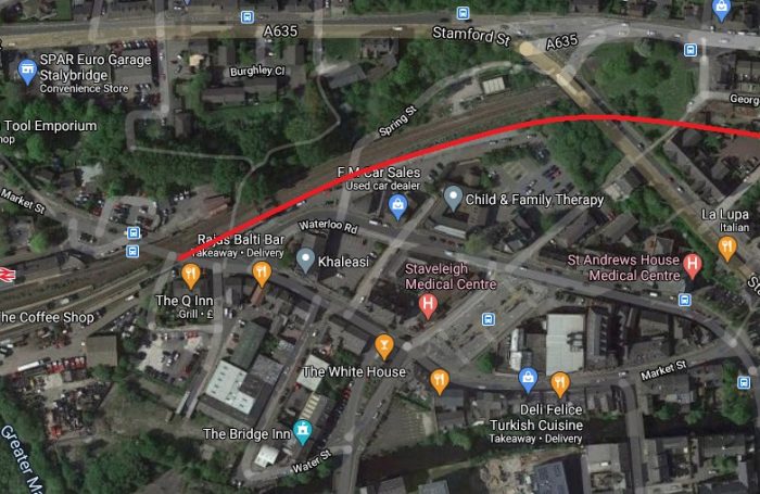
This modern satellite image covers approximately the same area of Stalybridge as the map extract above. The route of the former Micklehurst Loop is highlighted by the red line.
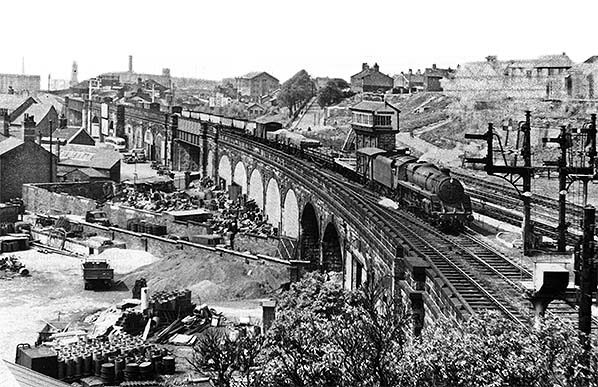
Looking west towards Stalybridge Station circa 1960 from Stamford Street BR standard Class 5 No.73162 takes the Micklehurst Loop as it pulls away from Stalybridge Station with a Huddersfield-bound freight and approaches Stalybridge New Tunnel. Photo by Peter Sunderland courtesy of Alan Young. [7]

The Western portal of Stalybridge New Tunnel sits just to the East of the Bridge that carries Stamford Street over the route of the Loop. It is difficult to photograph and access is not easy. While search for images of the line I came across a video on YouTube:

This video shows the Western end of the tunnel and then covers a walk through the full length of the tunnel and a glance out of the Eastern Portal. [8]

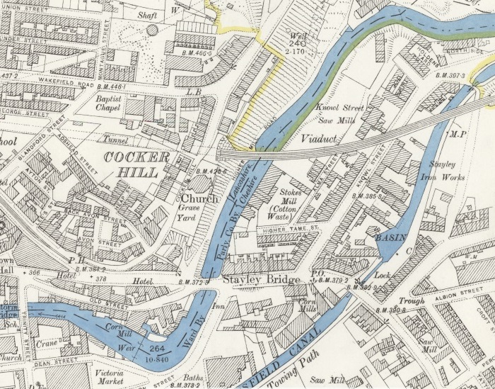
This next map extract shows the Micklehurt Loop emerging from the tunnel under Cocker Hill. The main line is in tunnel further North. Just South of the tunnel mouth Old St. George’s Church can be picked out, an octagonal church building which has now been replaced by St. George’s Church which is off the map extract to the North. Immediately to the East of the tunnel entrance, the Loop crossed the course of the River Tame and the Huddersfield Narrow Canal on a Viaduct.
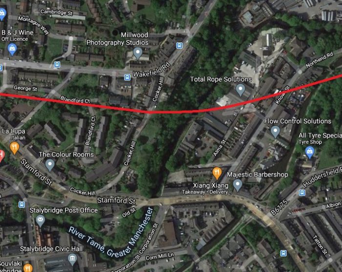
Much has changed in the satellite image above which covers approximately the same area. The canal basin can just be picked out, as can Knowl Street. The course of the River Tame is unchanged. Old St. George’s is long-gone. There is no evidence left of the Viaduct which carried the line.

Old St. George’s Church was located almost directly over the tunnel. It was an unusual church building and over its life was rebuilt twice on essentially the same plan. “The first was built in 1776. It was the first recorded church in Stalybridge and it did fall down shortly after it was built. The next church was demolished around a hundred years later because of structural problems and the last church was demolished in the 1960’s as it was no longer used.” [3]
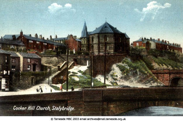
The last incarnation of Old St. George’s Church on Cocker Hill. This coloured monochrome image is held in the archives of Tameside MBC. The Micklehurst Loop can be seen exiting the tunnel below the church to the right and immediately crossing the River Tame on Knowl Street Viaduct. [4]
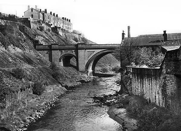
This monochrome image is provided with permission,  courtesy of Alan Young, once again. [7] He comments: “looking north up the River Tame the western end of Knowl Street Viaduct in Stalybridge is seen in this undated view. Having crossed this 16-arch viaduct the Micklehurst Loop promptly plunged into Stalybridge New Tunnel through Cocker Hill (left). This section of line ceased to handle traffic in 1972, when coal movements to Hartshead Power Station (near Staley & Millbrook) ceased, and the line was taken out of use in July 1976, but it was not until 1991 that the viaduct was demolished.” [7]

The Eastern Portal of the tunnel, which was directly below the church can still be reached with a little careful clambering. The image below has a Creative Commons Licence. (CC BY-SA 2.0).
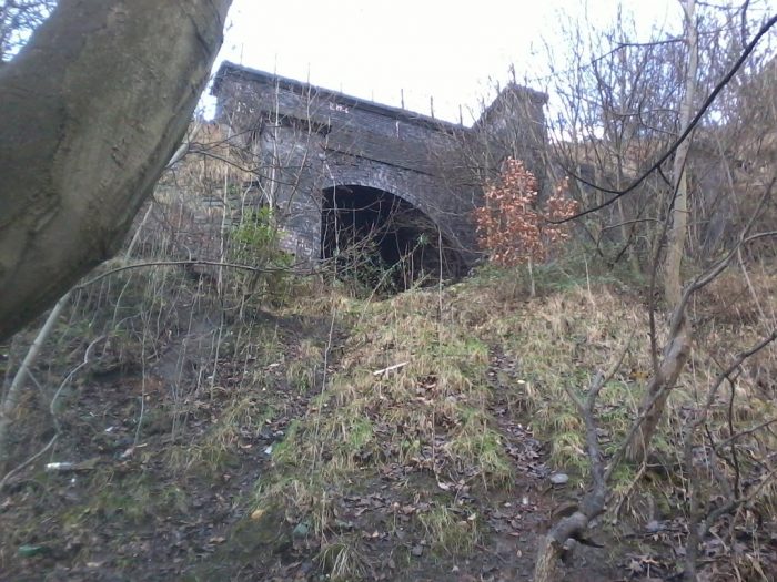
The East Portal of Stalybridge New Tunnel which is directly below the site of Old St. George’s Church © Copyright Tom Hindley and licensed for reuse under a Creative Commons Licence. (CC BY-SA 2.0). [5]

Knowl Street Viaduct carried the Loop over the River Tame, Knowl Street and the Huddersfield Narrow Canal and a series of arches in between. There were 16 arches in all.
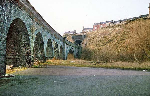
This photograph taken from the East alongside Knowl Street Viaduct is included with permission, courtesy of Alan Young. [7] Alan comments: “The Micklehurst Loop diverged from the original Huddersfield-Manchester line a short distance east of Stalybridge station, entered Stalybridge New Tunnel (about 300yd in length) then promptly crossed the broad valley of the River Tame on Bridge No.3 (also known as Knowl Street Viaduct). This impressive curving viaduct, in the blue engineering brick used by the LNWR on the Loop’s major structures, was 330yd in length with 16 arches. In addition to crossing the River Tame, the viaduct also strode across Huddersfield Narrow Canal and three roads. In this undated westward view, the viaduct and Stalybridge New Tunnel through Cocker Hill are shown. Coal trains that served Hartshead Power Station ceased to run over the viaduct in 1972, but it was not until July 1976 that the line was officially taken out of use. Fifteen years elapsed before the viaduct was demolished in 1991.” [7]
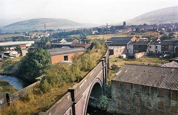
A further image used with permission, courtesy of Alan Young. [7]  Alan comments: “Looking north-east from a point close to the eastern portal of Stalybridge New Tunnel. The Knowl Street Viaduct, 330yd in length and with 16 arches, is seen crossing the River Tame then curving away towards the next station of Staley & Millbrook. The local passenger service on the Micklehurst Loop, on which this viaduct was located, ceased in 1917, but occasional passenger trains and many freight workings continued into the 1960s; coal traffic continued to pass over the viaduct until 1972 en route to Hartshead Power station near Staley & Millbrook station and the line was officially taken out of use in 1976. Nature is taking over the former trackbed as seen on this undated photograph. The viaduct was demolished in 1991.” [7]
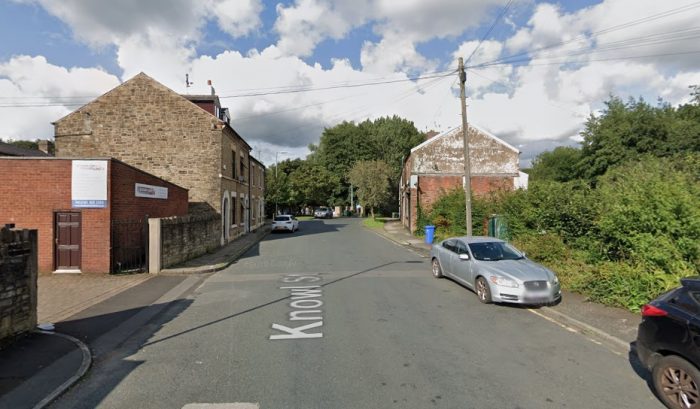
A modern view of Knowl Street taken from Google Streetview. Knowl Street Viaduct crossed Knowl Street at this location. The spandrel walls on the North side of the Viadct passed very close to the gable end of the terraced building to the East of Knowl Street, the righthand side in this view.

After crossing the Huddersfield Narrow Canal the Loop line regained the embankment shown on the next OS Map extract below. Just to the North of the point where the viaduct crossed the canal is a stone bridge carrying what is now (in the 21st century) the canal-side walk. That bridge is shown at the centre of the Google Streetview image below and at the bottom left of the OS Map extract. It is named Knowl Street Bridge and carries the number 97. [8]

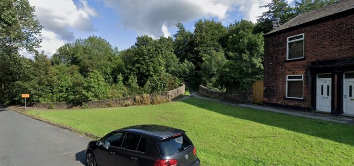
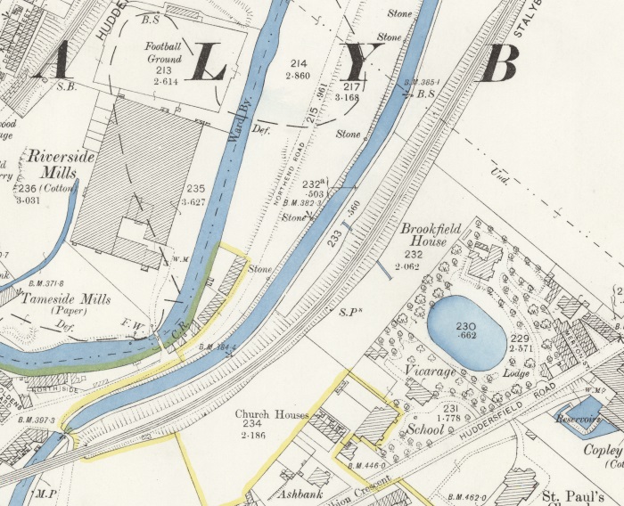
After crossing the Canal the line was carried on embankment, passing to the West of Brookfield House and running North by Northeast parallel to the Canal with Huddersfield Road a distance away to the South. Across the valley of the River Tame to the West were Riverside Mills.
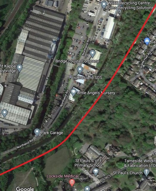
The approximate line of the railway, shown in red, runs parallel to the canal. We parked in a small car park just off the south of this satellite image, as illustrated below. The image shows that the site of the Riverside Mills is now occupied by the premises of Smurfit Kappa, Stalybridge. [9]
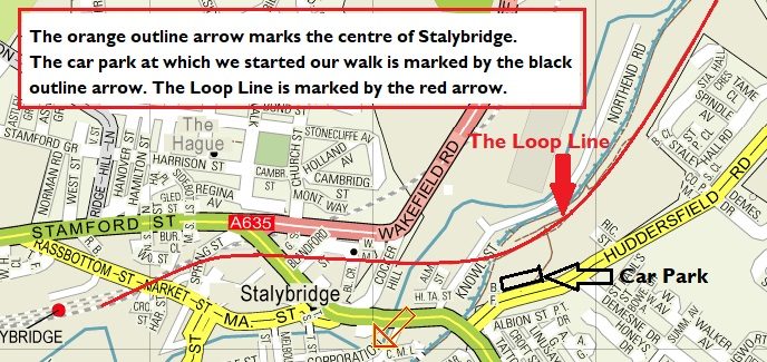
Stalybridge and the Southwest end of the Micklehurst Loop.

Brookfield House was  “a large detached house built in the early 19th century for James Wilkinson, and shown on the 1850 Stayley Tithe Map. All that remains is the former mid-19th century lodge house at 93, Huddersfield Road, with the entrance to the former drive with stone gate piers on its south side. The grounds of Brookfield House are clearly shown on the 1898 OS Map, and included an oval lake and glasshouses, …. Brookfield House was demolished and the lake filled in between 1910-1933. The grounds are now overgrown with self-set woodland.” [2]
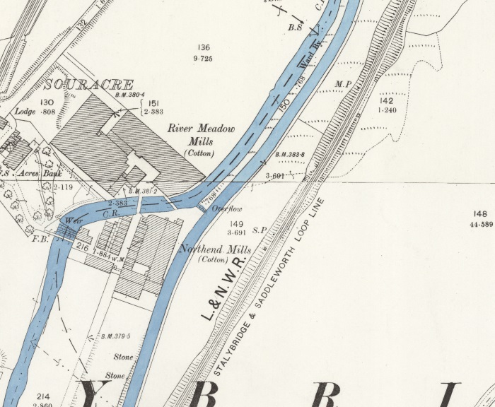
This next OS Map extract illustrates, at the the top right, how tightly the river, railway and canal follow each other at times up the Tame Valley. The railway sits above the canal which in turn sits a little above the river. Also evident is the name used on this series of OS Maps for the Loop Line – the “Stalybridge and Saddleworth Loop Line.”

Alan Young explains: “Although described as both the ‘Stalybridge & Saddleworth Loop‘ and ‘Stalybridge & Diggle Loop‘ on Ordnance Survey maps, the line is more commonly known as the ‘Micklehurst Loop’.” [7]

River Meadow Cotton Mills were owned by Henry Bannerman who was a successful farmer in Perthshire, Scotland At the age of 55 in 1808 he “moved with his family to Manchester, determined to get involved in the burgeoning Lancashire cotton industry.” [10]

At one time the company had “four cotton mills in the Manchester area: Brunswick Mill in Ancoats, Old Hall Mill in Dukinfield and the North End Mill and River Meadow Mill, both in Stalybridge.” [10]

In 1929, the Lancashire Cotton Industry was struggling. It had not regained its markets after the First World War. In an attempt to save the industry, the Bank of England set up the ‘Lancashire Cotton Coroporation’. Bannermans’ mills were taken over a few years later. The mills were acquired by Courtaulds in 1964 and all production ceased in 1967.” [10] After closure the four-storey mill which was Grade II Listed “was used by Futura before they moved to Quarry Street and then S. A. Driver warp knitters, dyers , printers and finishers.” [11] As can be seen in the satellite image below, the Mill is now demolished.
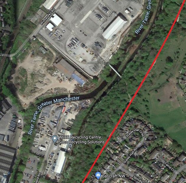
Souracre and River Meadow Cotton Mill and Souracre in the 21st century .

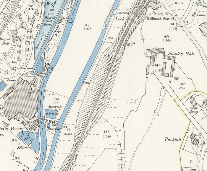
North of Souracre and visible at the bottom left of this next OS Map extract were Hartshead Calico Print Works East of Printworks Road and close by Heyrod Hall. Also visible on this map extract are Stayley Hall and the first Station on the Micklehurst Loop – Stayley and Millbrook Station.

Hartshead Print Works – is visible just below centre-left on the OS Map extract above. The works was listed in the Stalybridge Directory of 1891 as owned by John L. Kennedy &Co. Ltd, Calico Printers. lt was purchased in 1899 by the Calico Printers Association. [18]

Heyrod Hall – is shown on the top left of the OS Map extract above.

Stayley Hall – is a Grade II* Listed Building which dates back to at least the early 15th century.[14] The first records of the de Stavelegh family as Lords of the Manor of Staley date from the early 13th century. Stayley Hall was their residence. [15]

It came into the possession of the Assheton family through marriage and united the manors of Stayley and Ashton and thence into the family of Sir William Booth of Dunham Massey. In the middle of the 16th century. [15]

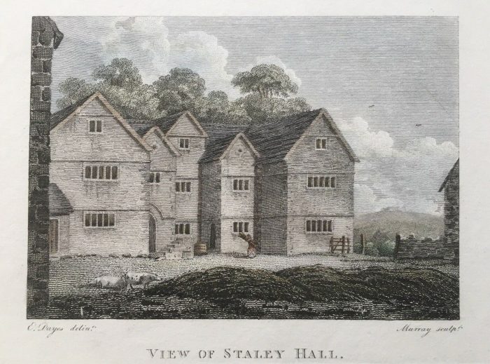
Stayley Hall 1795. [21]

In the middle of the 18th Century the Earldom of Warrington became extinct and the Hall, alonng with all the Booth’s estates passed to Harry Grey, 4th Earl of Stamford. Stayley Hall was owned by the Booth family until the death of  Roger Grey, 10th Earl of Stamford in 1976. [15]

Wikipedia concludes its history of the Hall as follows: “In 2004 the Metropolitan Borough Council announced that they had granted permission to a developer to build 16 homes next to Stayley Hall. A condition of the planning consent was that the hall be restored.[3] The developer has converted the hall and outbuildings into houses and apartments, most of which are now occupied.” [15]

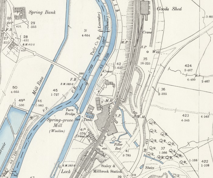
Early 25″ OS Map covering the length of the passenger facilities and most of the goods facilities at Staley & Millbrook Station. [1]

Staley and Millbrook Station – Alan Young’s on his webpage about the Station comments as follows: “Staley & Millbrook station stood on a steep slope immediately south of Spring Grove Viaduct.  The two facing platforms were equipped with waiting rooms, most likely of timber construction, with glazed awnings, as is thought to have been the building style at all four of the Loop’s stations. The platforms, too, were most likely of timber construction as that material was used for the platforms at Micklehurst, where they were also on an embankment, and timber would be a much lighter load than masonry for an embankment to support. The stationmaster’s house and adjoining single-storey office range to its west faced Grove Road across a small, triangular forecourt. The station house was constructed of dark red brick with string courses of blue engineering brick and pale stone lintels.” [18]Staley & Millbrook Station building and the Sprong-grove Viaduct take from the East on Grove Road in the early 20th century. The picture shows a clean and relatively well maintained site, very different to what remains in the 21st century, please see the pictures below. [18]
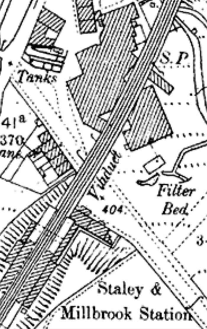
Staley and Millbrook Railway Station and Spring-grove Mill. [16]

Staley and Millbrook Station buildings have long-gone as has the Viaduct, the first arch of which spanned Grove Road and looked to be a graceful structure. Also of interest in the monochrome picture of the Station and Viaduct above is what appears at first sight to be evidence of a tramway or industrial railway in the cobbles of Grove Road. I have not as yet been able to find out anything about what this feature actually is. The feature is not marked on the map extract immediately above. Closer examination of the picture above suggests that rather than being part of a short industrial line the cobbles may have been laid to facilitate a particular movement around the Spring-grove Mill.

In the 21st century, this length of Grove Road has been tarmacked – a thin layer of tarmac covers the original sets. The next two pictures were taken on 30th January 2021 on a second visit to the site after walking the route of the Loop.

Taken from East of the route of the Micklehurst Loop, this photograph shows the location of the old station building. It sat facing the road on the left-hand side of the panorama. The Southern abutment of the viaduct sat adjacent to the station building, in the area of trees between the 5-bar field gate and the stone wall towards the right of the picture. The masonry wall is in the location of what were terraced houses between the canal and the railway viaduct. (My photograph, 30th January 2021)
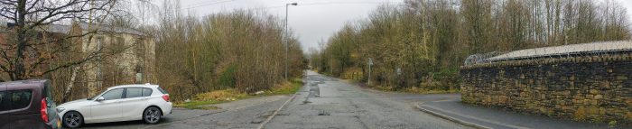
Another panorama, this time taken from the canal bridge to the West of the Loop. What is left of Spring-grove Mill can be seen on the left side of the image. Grove Road, heading towards Millbrook is central to the image. The masonry wall is the location of the terraced houses mentioned above. The first trees beyond it mark the line of the viaduct. The station building was sited beyond to the West. (My photograph, 30th January 2021)

Spring-grove Mill – As we have already noted, Spring-grove Mill is shown straddled by the viaduct on the OS Map extract above. When Staley & Millbrook station opened, “there was already some population and industry in the immediate neighbourhood. Spring Grove Cotton Mill faced the station across Grove Road, and map evidence suggests that the railway’s viaduct sliced through the existing mill building. A terrace of three cottages, also pre-dating the railway, stood immediately north of the platforms, and Stayley Hall was about 100yd south of the station. Millbrook village, with three cotton mills, was about ten minutes’ walk uphill east of the station.” [16] [18]
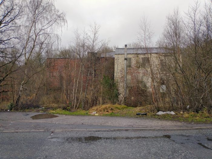
The remaining buildings of Spring-grove Mill. The lighter (cream painted) brickwork is the part of the mill shown on the map extracts as being on the East side of the viaduct. The portion of the Mill to the West of the viaduct has been demolished. The red-brick portion of the remaining building would have been under the arches of the viaduct. The Western spandrels of the viaduct arches would have followed a line running from the intersecting kerb-stones in the right-foreground over the redbrick part of the present building. (My own photograph – 30th January 2021)

Spring Grove Mill was a cotton mill from 1818 to 1868 and then was a woollen mill for 100 years, it was the last steam-powered mill in the area. [17] The image of Hartshead Power station below, includes Spring-grove Mill in the bottom right-hand corner. By the time the aerial photograph was taken Grove Road appeared to extend across the Canal and the River Tame towards Heyrod.

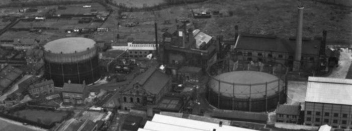
Hartshead Power Station was also located North of Souracre to the West of the River Tame. It was a coal-fired station and was served by trains on the Micklehurst Loop up until the 1970s. The picture immediately below was posted by Tameside Council on their Facebook page in 2015.
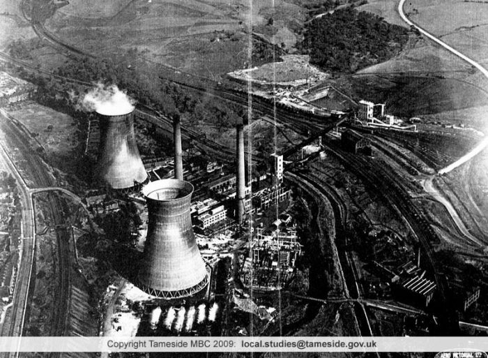
An aerial picture of Hartshead Power Station taken before the Second World War. It was opened by the Stalybridge, Hyde, Mossley and Dukinfield (SHMD) Joint Board in 1926 and the cooling towers were erected in the 1940s. The station closed in 1970 and was demolished in the 1980s. Although the Good Shed visible to the top right of the image still stands. The Micklehurst Loop curves from the bottom right to the top left of the picture. [13]
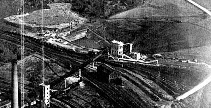
This enlarged extract from the image above show the coal transfer facilities and railway sidings associated with the power station . [13] The resolution of the image is not wonderful but it does highlight the traffic which was brought to the site throughout the middle 50 years of the 20th Century.

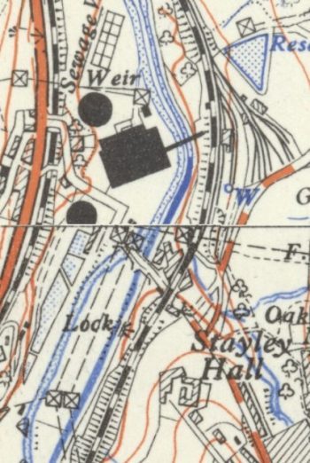
OS 1:25,000 Map form the early- to mid-20th century, sourced from the National Library of Scotland – Hartshead Power Station. One of the two cooling towers is not shown in full as it crosses the map join. [14]

The full extent of the Hartshead Power Station site at Souracre can be seen on the adjacent OS Map extract from the middle of the 20th century, which also shows the location of Stayley Hall and the Stayley and Millbrook Station build just North-northwest of Stayley Hall.

Approximately the same area is shown below on a relatively recent extract from the ESRI World Image website which is the satellite mapping used by the National Library of Scotland. [13]

The Good Shed which is considered further below is visible on both the map extract and the satellite image and the extent of the railway sidings on the East side of the Loop line is evident.

ESRI Satellite Image extract showing the current status of the Hartshead Power Station site with the approximate route of the Micklehurst Loop Line shown in red. The Goods Shed is still standing and can be seen just to the right of the red line. Along with the Loop line all of the lines in the sidings have ben lifted. [13]
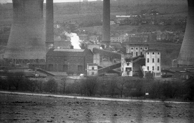
A view from the East looking across the power station site with the Good Shed and coal transshipment facilities in the foreground. the lack of trees compared with the satellite image and all other pictures of the site in the 21st century is striking, © Copyright David Dixon and licensed for reuse under this Creative Commons Licence. [23]

The substantial Goods Shed was built at the same time as the Loop initially with two sidings to its East. These sidings were expanded with the advent of the power station in the early 20th century. The site is now overgrown and is returning to nature. The only exception being the Goods Shed itself. There is an excellent video showing its current condition on ‘Martin Zero’s’ YouTube Channel which is embedded below. My own pictures of the site also follow below.

The Goods shed at Stayley and Millbrook Station presided over a large expanse of sidings which served Hartshead Power Station on the opposite side of the Huddersfield Narrow Canal and the River Tame. [22]
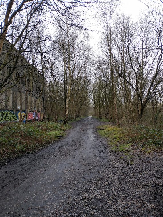
Looking South towards the location of the passenger facilities at Staley and Millbrook Station. The Goods shed is on the left (the East side of the Loop line). (My photograph, 18th January 2021).
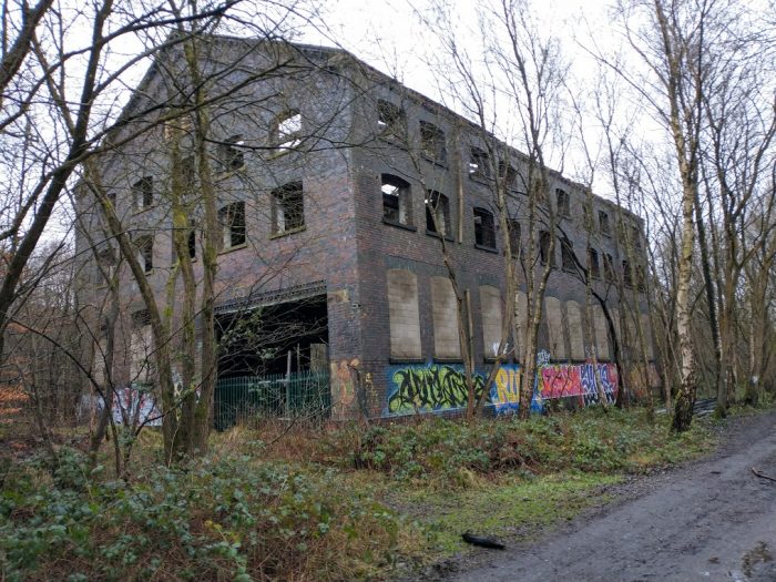
The Goods Shed taken from the same location as the last photograph – a substantial three-storey structure. (My photograph, 18th January 2021).

The next part of this walk following the line of the Micklehurst Loop sets off from this goods shed traveling North.

References

  1. https://maps.nls.uk, accessed on 18th January 2021.
  2. Copley Conservation Area Appraisal and Management Proposals; Tameside MBC, March 2013, p9-10.
  3. https://cockerhill.com/2010/07/06/old-st-georges-church-cocker-hill, accessed on 23rd January 2021.
  4. https://public.tameside.gov.uk/imagearchive/Default.asp & https://cockerhill.com/2010/07/06/old-st-georges-church-cocker-hill, accessed on 23rd January 2021.
  5. https://www.geograph.org.uk/photo/3119673, accessed on 22nd January 2021.
  6. http://nwex.co.uk/showthread.php?t=6918, accessed on 27th January 2021.
  7. http://disused-stations.org.uk/features/micklehurst_loop/index.shtml, accessed on 25th January 2021.
  8. https://canalplan.org.uk/waterway/cjdf & https://canalplan.org.uk/place/1hv4, accessed on 27th January 2021.
  9. https://www.smurfitkappa.com/uk/locations/united-kingdom/smurfit-kappa-stalybridge, accessed on 28th January 2021.
  10. http://cosgb.blogspot.com/2010/12/henry-bannerman-sons-limited.html, accessed on 28th January 2021.
  11. https://en.wikipedia.org/wiki/List_of_mills_in_Tameside#Mills_in_Stalybridge, accessed on 28th January 2021.
  12. http://www.table38.steamrailways.com/rail/Micklehurst/micklehurst.htm, accessed on 24th January 2021.
  13. https://scontent.fman2-1.fna.fbcdn.net/v/t1.0-9/10923473_10152970711638376_5311634515634523408_n.jpg?_nc_cat=102&ccb=2&_nc_sid=9267fe&_nc_ohc=TvOmLmn5KTcAX_Ayq7O&_nc_ht=scontent.fman2-1.fna&oh=2306db45618ba15e6bc27d582f00e643&oe=6037BA9F, accessed on 29th January 2021.
  14. Mike Nevell; Tameside 1066–1700; Tameside Metropolitan Borough and University of Manchester Archaeological Unit. p. 112 & 141, 1991.
  15. https://en.wikipedia.org/wiki/Stayley_Hall, accessed on 29th January 2021.
  16. https://m.facebook.com/story.php?story_fbid=784689891661955&id=121283594669258, accessed on 29th January 2021.
  17. https://www.google.com/url?sa=t&source=web&rct=j&url=https://www.tameside.gov.uk/countryside/walksandtrails/lowerbrushes.pdf&ved=2ahUKEwjXrum3xMHuAhVMTBUIHYmQAeQ4ChAWMAJ6BAgSEAI&usg=AOvVaw2DR5SZ9N3AM7__DD-ZN0Bv, accessed on 29th January 2021.
  18. https://gracesguide.co.uk/John_L._Kennedy_and_Co, accessed on 29th January 2021.
  19. https://www.28dayslater.co.uk/threads/stalybridge-new-tunnel-stalybridge-july-2012.72653, accessed on 26th January 2021.
  20. https://www.28dayslater.co.uk/threads/hartshead-power-station-heyrod-and-millbrook-2015-2019.119500, accessed on 29th January 2021.
  21. https://www.ebay.co.uk/itm/1795-Antique-Print-Stayley-Hall-Stalybridge-Greater-Manchester-after-E-Dayes-/292642997239, accessed on 29th January 2021.
  22. https://youtu.be/VdmWydx4VBw & https://www.facebook.com/martinZer0/?comment_id=Y29tbWVudDoxNTU4MjI2MDIxMDExNzUxXzE1NjA0NDMwMjQxMjMzODQ%3D, accessed on 31st January 2021.
  23. https://www.geograph.org.uk/photo/2204271, accessed on 31st January 2021.

Altrincham Gas Works Tramway

An item about the Altrincham Gas Works Tramway appeared on the Industrial Railway Society (IRS) email discussion group to which I belong. [2] John Pitman on that discussion group provided a link to Dr. Mark Newall’s website. [3]

This article grabbed my attention because for the first 5 years of my life in the early 1960s I lived in Altrincham – Broadheath, to be exact. I was born in Altrincham Maternity Hospital in 1960.  I always keep my eye open for interesting snippets of information about the various places that I have lived.

In 1870-72, John Marius Wilson’s Imperial Gazetteer of England and Wales described Altrincham like this:

ALTRINCHAM: …. “a town, a township, two chapelries, a subdistrict, and a district, in Cheshire. The town is in the parish of Bowdon, at an intersection of railways, adjacent to the Bridgewater canal, 8 miles SSW of Manchester; comprises good streets and some handsome villas; is a seat of petty-sessions and county courts, and a polling-place; publishes a weekly news paper; carries on iron-founding, bone-grinding, timber sawing, much trade from neighbouring market-gardens, and much transit traffic, and has a head post office, three raIlway stations, two chief inns, a town hall of 1849, a literary institution in the Tudor style enlarged in 1864, a plain church of 1799, a church in the decorated English style built in 1867, a Wesleyan chapel in the Byzantine style built in 1864, five other dissenting chapels, a Roman Catholic chapel, five public schools, a medical hospital, charities £57, a weekly market on Tuesday, and three annuals fairs.-The township comprises 657 acres. Real property, £24,087. Pop., 6,628. Houses, 1,240.” [10]

But, there is no mention in Wilson’s work of a Gas Works present at the time!

It seems that in the 19th century, 3 different gas works existed in Altrincham. The earliest was established in 1844, initially intended to serve an immediate area around the works. It only lasted for 3 years before it was purchased and closed as the main Gas Works was opened in 1847.

South Trafford Archaeological Group produced a short piece about the Altrincham Gas Works just a few days before Newall’s article. As does Newall, they point out that the Altrincham Gas Works were built by 1847. Both add that the third Gas Works were railway related, established to supply gas for carriage lighting.

The light railway, or tramway, between the Gas Works and Altrincham Railway Station was not established until provision was made for it under the Altrincham Gas Act of 1893, as a single track of standard gauge. It cost £1,820 to build, was in operation by 1895 and for many years was horse-drawn.

The South Trafford Archaeological Group point out that, “The tramway ran from the sidings at Altrincham Station for roughly a third of a mile (c. 500m) to the gas works on Moss Lane, where a series of sidings ran around the site. The light railway carried coal for the gas works which was used in the production of ‘town gas’.” [4]

The majority of the length of the short tramway – as shown on the 25″ OS Map from the turn of the 20th century, soon after it was constructed. (The detailed layout in the Gasworks is shown below on enlarged OS Map extract.) This extract shows the line running from the Gas Works, along Moss Lane, to the railway station yard. [15]


The map extract above shows the line of the tramway from the Gas Works to the Railway Station Yard. The adjacent extract shows the track arrangement within the Gas Works at about the turn of the 20th century. [15]

“At the station end of the tramway, … the land alongside
the depository was owned by the gas company …; beyond there the land belonged to the railway but the tracks were the responsibility of the gas company. The gas company’s authority ended just before the two sidings became one (on the east side of the station yard).” [5: p198]

Before the tramway was constructed, “coal was conveyed by horse-drawn wagons along the streets to the gas works. The route between the station yard and the gas works was partly along what was, in effect, little more than a rough bridleway (later known as Moss Lane); although unsuited in some ways to the transportation of coal, at least there were no significant gradients to contend with.” [5: p197]

The demand for gas rose quickly in the second half of the 19th century. “By the 1890s the increasing demand for gas meant that easier access to a larger supply of coal … had to be sought. …. [The tramway] was in operation by 1895 and initially was horse-drawn.” [3]

This extract for the 6″ OS Mapping of 1899 also shows the relatively newly constructed tramway serving the Altrincham Gas Works. [8]

The use of horses pertained until the 1930s, when a Sentinel steam lorry running on road wheels was purchased. It was built “by Sentinel of Shrewsbury in 1924, was employed from 1933 to pull the coal trucks.” [4]

The growth in the use of gas in Altincham is evidenced by the increasing use of coal. By 1919, 20,000 tons was used during the year. By 1933, usage had risen to in excess of 32,000 tons of coal. [5: p201]

The Gas Works Tramway in Altrincham from above.. This image covers the curved sidings on the East side of Altrincham Railway Station. Coal wagons are much in evidence. This view was taken in 1927. [6]

An aerial image of the Gasworks taken from the South in 1951. Careful inspection wil show at least one wagon in the Gas Works site to the right of the Gasometer on the left side of the image. [7]

In 1943, a Peckett 0-4-0ST took over locomotive duties from the Sentinel steam lorry. Newell says that this was “Peckett’s W/No. 2034, a ‘Yorktown’ type 0-4-0ST, and the new tank engine was named ‘Arthur E Potts’, after one of the company directors.” [3] No. 2034 left Peckett’s works on 27th May 1943. [13]

The Peckett was joined by “a second locomotive …. in 1947, a four-wheel vertical boiler engine built by Sentinel (W/No. 9375).” [3] Dixon says that this was a diesel loco, [11] but research suggests that Sentinel (W/No. 9375) was a steam locomotive. Sentinel Locos with this range of Works Nos. were all steam-powered. An example is Works No. 9376 which Sentinel’s records show as a Vertical Boiler Steam Loco built in 1947 for ‘Ind Coope and Allsop’ and used at their Burton Brewery. [12] Millichip explains: “This type of engine, with enclosed cylinders and chain drive to the leading axle, was eminently suited to gas works duties. Coke dust, which proliferated in gas works, always seemed to be attracted to the motion and other moving parts of conventional locomotives, and when mixed with oil the effect was far from satisfactory.” [5: p203]

These two locos (Peckett and Sentinel) shared 4 or 5 trips per day between the Gas Works and the Railway Station Sidings on weekdays. [11]

The tramway ran eastward from the Southern end of the sidings at Altrincham Railway Station to the Gas Works where there were a series of sidings that served the Works. Newell says that the “line entered the gasworks from the south-west, passing a weighing machine and an associated building on the western side of the track. It then threaded its way between two gas holders before branching north and eastwards towards two process buildings. Three turn tables gave extra flexibility for the coal wagons accessing these buildings.” [3]

Newell writes about some of the various developments on the line over the years. His words do not need rehearsing in detail here as they can easily be read on his site: https://archaeologytea.wordpress.com/2020/08/10/the-industrial-archaeology-of-the-altrincham-gas-works-tramway [3]

In summary, Newell says that the essential changes were:

  • 1908: a short 50 metre siding running north from Moss Lane between Oakfield Road and Balmoral Road
  • 1936/1937: doubling of the tracks at the Railway Station.
  • various changes to sidings in the Gas Works over the years
  • 1951: a siding accessing a processing building to the East end of the Gas Works site.

Millichip talks of the siding at the station being very difficult to shunt because there was only a small passing loop available. This meant that a rope hawser was used to facilitate shunting. The two sidings mentioned by Newell above  were not connected in a way that would allow either of the Gas Works engines to run round the wagons delivered to the Station Goods yard. [5: p203] Millichip and Robinson provide two excellent shots of the rope -shunting taking place. [5: p203 & p204] In the second of these pictures the short passing loop is visible.

The Altrincham Gas Works was nationalised in 1949 when it became part of the North Western Gas Board. Millichip tells us that North Western Gas Board was one of twelve gas boards set up at Nationalisation and took over not only the Gas Works but nearby offices and a gas showroom on Cross Street in Altrincham [5: p204]

Gas production at Altrincham ceased on 26th June 1957. [5: p204] Newell tells us that the tramway was closed in December 1957, track was removed in 1958, and the Moss Lane site became the headquarters of the Gas Board, opening in 1965. The two gas-holders at the Gas Works survived this work but did not survive beyond the end of the 20th century. [3] The whole site, including the headquarters building were redeveloped in the first decade of the 21st century as housing and a new ice-rink. [3][5: p204]

If you are interested, the process used at Gas Works is covered in an article on the International Good Guys website (https://www.igg.org.uk/gansg/12-linind/gasworks.htm). [14]

References

  1. M. Newall in Reference [3] below mentions a 14 year period. It seems as though the line was first constructed by around 1895 and was still in use in the late 1950s – see references [5] and [9] below.
  2. https://groups.io/g/IndustrialRailwaySociety
  3. M. Newall; The Industrial Archaeology of the Altrincham Gas Works Tramway; 10th August  2020; https://archaeologytea.wordpress.com/2020/08/10/the-industrial-archaeology-of-the-altrincham-gas-works-tramway, accessed on 15th December 2020.
  4. https://stagarchaeologymanchester.wordpress.com/2020/08/07/exploring-altrinchams-gas-works-tramway accessed on 15th December 2020.
  5. Malcolm Millichip & Douglas Robinson; Altrincham Gas Works; Railway Bylines Magazine, Irwell Press, Vol. 5 Issue 5; April 2000, p196-204.
  6. https://britainfromabove.org.uk/image/epw017603, accessed on 16th December 2020.
  7. https://britainfromabove.org.uk/en/image/EAW036247, accessed on 16th December 2020.
  8. https://maps.nls.uk/geo/explore/#zoom=17&lat=53.38629&lon=-2.34401&layers=6&b=1, accessed on 16th December 2020.
  9. The Museum of Transport Greater Manchester has shared an image from 1959, showing the tramway in productive use; https://flic.kr/p/2jy9WSY, accessed on 16th December 2020.
  10. John Marius Wilson; Imperial Gazetteer of England and Wales; 1870-1872. https://www.visionofbritain.org.uk/place/549, accessed on 10th January 2021.
  11. F. Dixon; The Manchester South Junction & Altrincham Railway; 2nd ed. Oakwood Press, 1994.
  12. https://preservedbritishsteamlocomotives.com/sentinel-works-no-9376-no-7-0-4-0-vbgt, accessed on 10th January 2021.
  13. https://www.rmweb.co.uk/community/index.php?/topic/70791-pecketts-yorktown-class/page/2, accessed on 10th January 2021.
  14. https://www.igg.org.uk/gansg/12-linind/gasworks.htm, accessed on 15th January 2021.
  15. https://maps.nls.uk/geo/explore/#zoom=16.193710244992022&lat=53.38569&lon=-2.34339&layers=168&b=1, accessed on 15th January 2021.


Into 2021 with God! – Genesis 1:1-5 and Mark 1:4-11 – 10th January 2021

The authors of our lectionary placed the Old Testament reading alongside the Gospel reading for  10th January 2021 for a reason. They wanted us to see them in parallel.

In both cases God is doing something new.

I am not an expert in classical music, a bit of a Philistine really, but as I thought about these two readings from Genesis and Mark it seemed to me that they could be described as two different movements from the same symphony. I’m told that the classical composers used variations on the same theme to develop their composition and that if you listen carefully to the music you can hear the main theme being repeated. …..

Perhaps you can imagine a heavenly orchestra playing the first 5 verses of Genesis. Dark, brooding music portrays an overwhelming sense of chaos and darkness. I imagine that the composer would use discordant modern themes to convey a sense of disorder. Then over this music comes the main theme of the symphony – quietly at first, starting with flute and piccolo, and gradually engaging the whole orchestra. Like a wind gradually rising from a gentle breeze to a violent gale. God’s mighty wind (his Holy Spirit) sweeps across the universe. God is speaking, and his very words change the universe for ever. “Let there be light” and light appears. God saw that it was good, and Night and Day were born.

God breaks into the history of the universe with a powerful word of creation.

Our second reading comes much later in the same symphony. The main musical themes are now well developed – we=ve heard them over and again throughout the symphony. When John the Baptist appears we return to that same discordant, abrupt and harsh theme that we heard right at the beginning of the symphony. His harsh manner, his odd clothing, his strange habits all seem to echo the chaos and darkness of Genesis. The sound from the orchestra builds and noise of the crowds coming to John for baptism shake the concert hall and then John’s voice can be heard as a sharp solo, perhaps, by the oboe cutting through the surrounding noise.

Then quietly at first the main theme appears again. The theme that represented God at work as Creator gradually supersedes the chaos of the early part of this movement. Jesus has come for baptism. The Word of God, from the beginning of John’s Gospel, is beginning his work. And as Jesus comes up out of the waters of baptism the whole orchestra joins the theme – the heavens are rent open, the Holy Spirit descends on Jesus and God speaks, a strong solo voice: “You are my Son, the Beloved; with you I am well pleased”.

Can you see the common themes in the two passages?

  • The milling crowd, longing for God to act in their lives; and the universe awaiting God’s creative action.
  • The wind of God, and the Spirit of God hovering over the waters of the deep and the waters of baptism.
  • The word of God bringing creation, “Let there be light”; and the Word of God, Jesus, God’s Son, whose ministry brings redemption.

God’s delight is obvious in both passages. Looking at creation, ‘God saw that it was good’. Looking down on his Son, God said, “You are my beloved Son, with you I am well pleased”.

The theme from each movement of our symphony is the same. God creating his world and God redeeming that same world. All part of the same plan. In our symphony, both represented by the same theme.

And now, early in 2021, we are participating in what the Bible calls the end times, the days between Jesus’ first and second coming. We are participating in what we might call the final movement of the symphony.

In the first movement, God saw that everything was good. What does he see now, at the start of this new year, in Ashton, in our churches, in our families and personal lives? Where are the signs of new creation? Where are the dark, formless voids that still await God’s creative action?

In the later movement God expressed overwhelming pleasure at the baptism of his Son. What things in our world, our town, our churches or in our lives today, give God pleasure?

Where might we begin to hear that same musical theme of God’s intervention here in Ashton-under-Lyne? What do we long that God would do in our town and in our world?

At this moment the pandemic looms increasingly large and we can feel the discordant notes of fear and anger. The discordant music seems to dominate our lives, yet quietly, almost unheard in the chaos of noise that theme of hope is still present quietly picked out again by flute and piccolo bringing a measure of calm in the midst of the noise.

How might the final movement of our symphony be being played out? What should I do? What should we do to participate in God’s work here? Now, in these difficult times? Which of the musical voices are we contributing to? The discordant chaos or the still, small, haunting voice of calm and hope?

The Uganda Railway in the first 5 years after World War 1

I recently picked up a copy of each of the two volumes of ‘Permanent Way‘ written by M.F. Hill and published in 1949. The first volume [1] is a history of ‘The Uganda Railway’ written in the 1940s when the railway company was known as ‘The Kenya and Uganda Railways and Harbours’ and published at the end of that decade under the jurisdiction of the new ‘East African Railways and Harbours’ which was formed to formally include the infrastructure in the modern country of Tanzania.

Hill’s first volume provides a detailed history of the Uganda Railway until just after the end of World War II. This article covers the period between WW1 and WW2.

In the years immediately after WW1, further European settlement was encouraged and ‘European’ electoral areas were set up. By 1921, the Census revealed the European population of the EAP to be 9,651 and the Indian population to be 22,822. [1: p379]

No effective provision was made in the 1919 Ordinance which established the European franchise, for Indian elected representatives. This was a cause of Indian resentment [1: p379f] Changes in India led to a greater Indian interest in politics in what, in 1920, became the Kenya Colony. The annexation of the EAP took place in June 2020, only the area lease from the Sultan of Zanzibar were excluded (a 10 mile wide costal strip).

In addition to the Indian issue, political turmoil/controversy revolved round issues which had an ill-effect on the new colony’s economy. These included:

  • the virtual bankruptcy of The Uganda Railway;
  • the need for drastic reorganisation;
  • the lack of aboriginal contribution to the colony’s economy – the native population was producing little of value on world markets;
  • the Indian community had yet to make a net contribution to the economy of the Colony.

The number of ex-pat European farmers was only 1,339, most in financial difficulty because of lack of experience, falling prices and a “disastrous currency conversion.” [1: p381] …… The rising value of the Indian Rupee against the pound resulted in a dramatic increase in the sterling value of all local services and commodities. The European settler in 1919 received 850 rupees for £100 instead of the rate before the War of 1500 Rupees for £100. If the £3 million loan first discussed in 1913 had been raised in 1919 its value would have been a third less than in 1913. The farmer also received far fewer Rupees for his sterling exports – he had to sell twice as much produce to meet his liabilities. [1: p382]

After much debate and extensive negotiation the sterling value of the East African Rupee was fixed at 2 Shillings. This was relative parity with the Indian Rupee at the time, but within 6 months the exchange rate in India settled back to historic levels of around 15 Rupees to the pound. [2: p384f]

Settlers costs were as a result fixed at a very high level, their income was held down and then they had to watch as Government salaries were increased by 50% to maintain the value of salaries at an equivalent sterling value. All government related costs charged to settlers where increased by more than 50%. [1: p385f]

Pressure to revert to a conversion rate of 15 Rupees to the pound was resisted by HM Government, the 2 Shilling (Florin) of the Rupee was maintained. However, a local review highlighted a need to create a lower standard denomination and this was eventually accepted. The order came into force on 1sr January 1922 and the Shilling became the standard currency its value set at 20 Shillings to one pound sterling. [1: p388]

The new currency maintained the high exchange rate and as a result local costs had to be reduced. Native labour lost 33% of the increase which came from the high exchange rate although, in practice, this meant that their buying power returned to historic levels.

Hill comments that another effect was the greater pressure placed on the aboriginal/indigenous populations in the reserves to take up paid employment outside the reserves. The terms on which this occured were seen by Mission Societies and the Aboriginal Protection Society. Hill says that this was an ill-informed response, however the parallel scheme in Uganda was more onorous. “In Uganda a native could be called out to work, by compulsion and with no pay, for thirty days a year,band for a greater variety of communal purposes than in Kenya.” [1: p392]

Hill says that by 1920, Kenya was planning to extend the line across the Uasin-Gishu Plateau towards Uganda and the Thika Line to Nyeri. The lack of local labour resulted in the Kenyan authorities it arrangements for forced labour into line with Uganda which inevitably drew more criticism. [1: p392]

Hill tells of a significant debate over the relative merits of the settler’s need for labour and the protection of the rights of indigenous labourers. By 1921, Winston Churchill, who had just inherited the role of Secretary of State ensured that the Kenyan Government would only use forced labour when it was absolutely necessary. In 1922, this became a statute at the time when it also became a requirement to seek HM Government approval for the use of compulsory labour. In 1923, Uganda followed suit. [1: p393]

Between 1919 and 1939, compulsory labour was only once called upon to work for the State. “In 1925 the Secretary of State agreed that compulsory labour should be employed on the extension of the Uasin Gishu Railway and on the line from Thika to Nyeri. In each case the need was urgent, because construction was severely retarded – with heavy financial loss – by a lack of labour. The largest number of compulsory labour employed in any one month was 1,500 on the Uasin Gishu line and 1,300 on the Thika-Nyeri line.” [1: p394]

Hill notes that as of the end of March 1920 the outstanding grant and loan balances available to improve the railway were £1,301,033. The settlement of the rupee-shilling conversion in 1921 enabled the colony to raise a loan of  £5 million of which over £4.2 million was designated for use on the railway.

In May 1921 it was decided at a meeting in London that the financial year of the Kenya Colony should become the same as the calendar year.

Over the next few years, the recall of the Military Governor, Sir Edward Northey, led to a significant change in direction for the colony. Northey had worked to the dictum that European interests were paramount and that Indian interests should not be ignored [1: p397ff] The new commitment of HM Government is described by Hill, quoting from the Devonshire White Paper: [2]

“The general policy underlying any decision that may be taken on the questions at issue must first be determined. It is a matter for satisfaction that, however irreconcilable the views of the European and Indian communities in Kenya on many points may be, there is one point on which both are agreed, namely, the importance of safeguarding the interests of the African natives. …” [1: p399]

This policy change was significant. Hill says that HM Government now regarded “themselves as exercising a trust on behalf of the African population, … the object of which may be defined as the protection and advancement of the native races.” [1: p400]

Whether Hill interprets the situation correctly may be open to interpretation, certainly the Wikipedia article about the White Paper suggests a slightly different motivation. [2] However, it does seem to be the case that the net result was Kenya avoiding the route that was pursued in South Africa and Southern Rhodesia. [2]

Returning to focus more directly on The Uganda Railway. … The Working Profit of the Railway, even when enhanced by some creative accounting was much lower immediately after WW1 than in earlier years. The figures from within Hill’s account are:

1919-1920         £62,582        [1: p402]

1920-1921      £155,916        [1: p404]

1921                  £15,883        [1: p407]   –   only 9 months and in the midst of a worldwide depression.

1922                  £56,785        [1: p436]

1923                £300,910        [1: p439]

34 No. ‘G’ Class locomotives were delivered by the North British Locomotive Co. and 17 of these were in service by the end of March 1920. At that time, two more were on order from Nasmyth, Wilson & Co. Ltd. A daily service once again became possible along the full line. However, of the 36 new locomotives, 21 were intended for the Magadi Line traffic. [1: p402]

It was as late as 1st April 1921 that the Secretary of State finally rules that the working profit of the railway was no longer to be regarded as available for general colonial revenue purposes and that any surplus generated was to be used:

  • first, for renewals, upkeep and betterment of the railway;
  • second, for meeting loan charges on future development costs;
  • third, for a reduction in railway rates. [1: p404]

Hill notes that the general improvement in the economy brought significant pressure to bear on the railway – the numbers of engines, carriages and goods wagons available  for use was short, it seemed, on what demand required. Despite night-shift working in the maintenance facilities, 24 engines were in the year awaiting overhaul in August 1920. [1: p405] These problems were mitigated by using 17 locomotives and 108 covered wagons intended for the Magadi Line, as anticipated traffic did not arise from the Soda Works until 1921. [1: p406]

At the end of 1920, Lieut.-Colonel F.D. Hammond was appointed by the Secretary of State as Special Commissioner for Railways, Eastern Africa. He arrived in Kenya on 20th January 2021 and left on 24th August 2021 after completing his tour of investigation. His report brought about a new era in the history of The Uganda Railway [1: p409,410]

Meanwhile, Hill writes, there was a significant debate being played out over the route of the Uasin0Gishu Line. An argument had been put forward for a revised alignment which left the existing main line  on the Mau Plateau rather than at Nakuru. There would have been significant initial cost savings if proponents of this route were to prevail. However, given the increasing levels of traffic from Uganda, major improvements on the existing line between Nakuru and Mau Summit would inevitably be necessary in the relative near future. The ruling grade would have needed to be improved from 2% to 1.5% and concomitant improvements to structures would also be required if transportation costs were to be kept as low as possible. The originally surveyed route from Nakuru would, while costing more initially, would result in lower transportation costs. [1: p410-414]

Hill comments: “There is no doubt that the conclusion reached … in favour of the Nakuru route was sound, although much of the financial argument could not be sustained. … The line took far longer to build than was expected, it proved exceedingly expensive and, during the building, there was persistent friction between … the Chief Engineer … and the senior representative in Kenya of the contractors.! [1: p141]

Hammond, says Hill, reported in May 1921 that he was in full agreement with the Nakuru route “being economically the proper one to choose.” [1: p415] He strongly urged acceptance of that route. Hill goes on to say that while this debate was raging, “Hammond was devising a plan for the complete reorganisation of the railway.” [1: p415]

A new ‘Inter-Colonial Railway Council’ was set up with terms of reference provided by Lord Milner, the Secretary of State, which made that Council the effective administration authroity for the railway and all auxiliary services. Hill says that they were “to be administered as a single instrument for the benefit of Kenya and Uganda by a body of men who, with the expection of the Chairman (Hammond was in the Chair at first) were unlikely to have much experience of railway policy or practice.” [1: p419]

When Hammond left Kenya in August 1921 the position of General Manager of the railway was decreed by the Secretary of State as including the role of Chair of the Council. [1: p422]

Hill goes on to discuss the Hammond report – the main points raised were that there:

  • had been gross inefficiencies in freight transport – goods from Kisumu to Mombasa were taking close to 8 days to travel a distance for which the working timetables allowed 2.5 days. Goods from Mombasa to Nairobi were taking as much as 12.5 days to cover the scheduled running time of 1.33 days. Hammond estimated that the efficient running of the network would result in an 11% surplus capacity with the existing availability of goods wagons at the heaviest envisaged traffic levels (including for Magadi’s output). [1: p422-423]
  • was a need for a marked improvement of the telegraph system to ensure safe operating of the railway; [1: p 423]
  • was a need  a better cleaning regime, particularly of passenger stock; [1: p 423]
  • was too much centralisation of maintenance and no progress in developing maintenance facilities, particularly for locomotives; [1: p 423-424]
  • were huge stocks of coal; [1: p 424]
  • was major work required to maintain/replace machinery in teh worskshops; [1: p 424]
  • were ineffective financial controls in the workshops and in the Chief Mechanical Engineer’s Department; [1: p 424]
  • was a major need for investment in replacement of time served timber buildings; [1: p 424-425]
  • was undue pressure on the General Manager from the Protectorate Government to minimise expenditure on the railway; [1: p 425]
  • was no programme for replacement of railway structures.  Although properly maintained, structures would not be adequate for the axle loads of the next generation of locomotives; [1: p 426]
  • was an over-provision of steamers on the Lakes with no possibility of sale to others; [1: p 426]
  • was no possibility of improving the capacity of Lakes steamers as Kisumu Port could not be developed to accommodate ships with a greater draught; [1: p 426-427]
  • were significant losses on the Busoga Railway and the Port Bell-Kampala line caused by a failure of the Railway to properly credit income to those lines. Thos losses were then being born by the Uganda Government; [1: p 427]
  • was a need to focus on generating traffic from Uganda and the Belgian Congo [1: p427]
  • was work to do to address expensive, slow and cumbersome systems in the Stores and Accounts Departments.
  • were too many staff drawn from India rather than from a wider pool and very little intention to employ local staff to do anything other than manual roles. [1: p427] This meant that the railway was entirely dependent on the economic and political circumstances which might arise in India. [1: p428]
  • had been a failure over 20 years to train local technical staff especially when compared to the situation pertaining in Tanganyika which had been in the German sphere of influence. [1: p428]

Hammond placed the highest priority for action on creating a comprehensive technical training scheme for local staff. He proposed the diversion of capital from the £300,000 fund set aside for the provision of additional rolling stock.

He instituted, with Railway Council agreement, a new goods tarrif system which focussed on maximising revenue. It had a tapering system of rates dependent on volumes carried and a far simpler classification of goods. The system was uniform across the network and ensured that “no transport be done at less than cost price.”[1: p429]

He also insisted that the General Manager should place a high priority on public relations and must “be directly represented on Chambers of Commerce and other local associations.” [1: p429]

Hammond estimated that the required annual contribution to a Renewals Fund should be around £280,000 and that there should also be:

  • a three-year programme to replace worn out plant/machinery at a cost of about £24,000/annum; and
  • a five-year programme of building replacement costing £112,000/annum. [1: p 430]

He emphasised the paramount importance of separating colony and railway finances, and suggested that capital costs for the development of the railway were for the colony to bear, withe the railway being tasked with the operating of the network. [1: p431]

Hammond also stipulated that, to ensure fair-dealing with Uganda, Kenya and Uganda should be placed under one Governor-General or High Commissioner to whom the railway would be responsible. [1: p432]

As a final matter, he looked into the status of the Voi-Kahe branch built during WW1. His recommendation was that “the last 57 miles of track at the Modi end of the Tanga line be picked up and used for the betterment of the costal section [in Tanganyika] and that the Voi-Kahe line be retained, regraded and realigned. He considered that the cost of the reconstruction of the Voi-Kahe line should fall upon Tanganyika as the chief benefactor, and he devised a financial arrangement whereby the Territory would bear all loss and collect all profit derived from the line. [1: p433]

Implementation of Hammond’s report was delayed by political issues. There was major controversy over the probable impact of his recommendations and implementation was delayed “pending further negotiations and discussions.” [1: p434]

The railway concentrated on reform of its own administration. The Railway Council pressed for urgent action where economies could be immediately effected. [1: p434-435]

In January 1922, the Council considered the reduction of coal stocks. It decided that the General Manager had acted in the best interests of the railway in purchasing the coal but considered that the information given to him “as to the state of the home markets at the time in question left much to be desired.” [1: p435] It was resolved to sell surplus coal stocks at the best prices obtainable.

At the end of 1922, a new General Manager was appointed. Within 3weeks or arriving, C. L. N. Felling, ” had devised a scheme for the control of the railway. It was discussed for nearly two years, but the eventual Order in Council differed little from Felling’s original draft. [1: p435]

After considerable debate, a final decision over the Voi- Moshi line was made. It was resolved to keep the line open. [1: p437-439] “Within a few years the line was paying its way, and it later became the first section of any railway in British Africa where the engines were driven by Africans, who also provided the bulk of the signal and station staff.” [1: p439]

At the end of 1923, the General Manager’s report announced a significant programme of new construction which included  the extension of the Uasin-Gishu line to meet the Busoga Railway in Uganda. “Considerable extensions and improvements to the mechanical workshops were carried out during the year and the repair of locomotives … was up to date. During 1823, thirty-seven engines were thoroughly overhauled, five were scrapped, … and twenty new engines were erected.” [1: p441]

A Uganda Railway GD Class 4-8-0 Locomotive. The first of these was built in 1923 by the Vulcan Foundry of Nasmyth, Wilson and Co. They were numbered 162 to 217 and layer became Class 24 Locomotives as The Uganda Railway developed. [6]

Hill comments: “Within a year, Christian Felling had created an amazing improvement in the working of the railway. The financial position and prospect had changed for the better beyond the most optimistic prediction. It was only the start of great achievement: in the next 4 years he was to transform the railway and it’s finances.” [1: p442]


References

  1. M.F. Hill; Permanent Way – The Story of the Kenya and Uganda Railway – Volume 1; Hazel, Watson & Viney Ltd, Aylesbury & London, 1949.
  2. Wikipedia notes: This document was intended to create “a compromise between Indian interests and those of the Europeans, despite its affirmation of African paramountcy. [3] Nevertheless, the Paper allowed for the (slow) improvement of African conditions, such as the establishment of technical schools for Africans by a 1924 Education Ordinance, as well as the appointment of Eliud Mathu to the Legislative Council, the first African to hold a seat. It also allowed for the formation of an African party, the Kikuyu Central Association, which presented African grievances to the colonial government. Although the Indians were prevented from settling in the White Highlands, they were granted five seats on the Legislative Council and immigration restrictions imposed on them by the white settlers were removed. [4] The White Paper was used by the British government to retain control over the Kenya Colony, and is cited as one reason why Kenya did not develop as a white minority ruled country, as South Africa and Southern Rhodesia did.” [5] https://en.wikipedia.org/wiki/Devonshire_White_Paper; accessed on 3rd January 2021.
  3. Robert M. Maxon; The Devonshire Declaration: The Myth of Missionary Intervention; History in Africa Volume 18,1991, p259–270.
  4. History and Government Form 2 Teachers Guide. East African Publishers. p91–92
  5. Robert M. Maxon; Struggle for Kenya: The Loss and Reassertion of Imperial Initiative, 1912-1923. Fairleigh Dickinson Univ Press, 1993, p270–279.
  6. https://en.m.wikipedia.org/wiki/UR_GD_class, accessed on 8th January 2021.

Epiphany 2021

Matthew 2: 1-12

In the bleak midwinter  by Christina Rossetti

In the bleak midwinter, frosty wind made moan,
Earth stood hard as iron, water like a stone;
Snow had fallen, snow on snow, snow on snow,
In the bleak midwinter, long ago.

Our God, Heaven cannot hold Him, nor earth sustain;
Heaven and earth shall flee away when He comes to reign.
In the bleak midwinter a stable place sufficed
The Lord God Almighty, Jesus Christ.

Enough for Him, whom cherubim, worship night and day,
A breastful of milk, and a mangerful of hay;
Enough for Him, whom angels fall before,
The ox and ass and camel which adore.

Angels and archangels may have gathered there,
Cherubim and seraphim thronged the air;
But His mother only, in her maiden bliss,
Worshipped the beloved with a kiss.

What can I give Him, poor as I am?
If I were a shepherd, I would bring a lamb;
If I were a Wise Man, I would do my part;
Yet what I can I give Him: give my heart.

The Feast of the Epiphany celebrates the moment when the story of Christ’s birth first becomes a matter for the whole world. Up until the appearance of the Wise Men, the Magi, the story is exclusive. All the main characters are from Palestine. All of them are Jews.

In Matthew 2: 1-12, we hear the story of how, after Jesus was born, some wise men from the East, from beyond the borders of what we now call Palestine and Israel, even from beyond the boundaries of the Roman Empire, heard that a King had been born. The Gentiles are at this point included in the story.

These wise men wanted to find the King so that they could worship him. They followed a star to Jerusalem and asked some priests there if they knew where to find the King. The priests knew where Jesus was to be born, because they had been told by the prophet Micah, so they told the wise men that they would find the new King in Bethlehem.

The Wise Men saw the star and chose to follow it, otherwise the Star would have been useless. …

So it is with all that God promises us in his Word. We need to respond to the gifts God gives us. We need to continue to grow in faith and commit to following God – and in doing so we make God’s promises our own. We find God to be trustworthy – God is there for us when we need him. This is the journey that each of us is on!

Wise men and women today are still seeking for Jesus. We don’t look for him in Bethlehem, because he is no longer there. He is on his throne in heaven. We don’t need a star to help us find him. We can find him by reading about him in the Bible, by sharing together in the bread and wine of communion, by talking together with others who know him well.

Just as the Wise Men brought gifts to the Christ-child, so Christina Rossetti reminds us that Christian faith is not just about how we receive the gifts and love which God gives, nor is it just about following the best path to the right place. The words of the last verse of her carol remind us that our faith is also about what we bring, about the offering of ourselves, the core of who we are, as a gift to the Christ-child.

What can I give Him, poor as I am?
If I were a shepherd, I would bring a lamb;
If I were a Wise Man, I would do my part;
Yet what I can I give Him: give my heart.