Monthly Archives: Mar 2020

Railways in Iran – Part 4 – 1970s

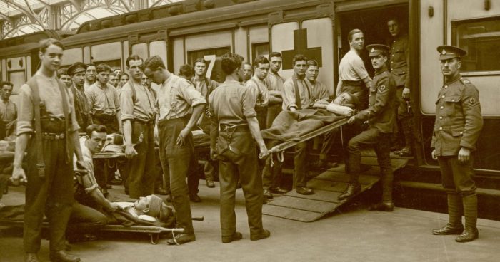
My recollections of the 1960s are vague. As a child I was almost entirely focussed on my immediate environment. The 1970s were a different matter. Events in the Middle East and in Iran began to intrude on my childhood. New of conflicts in Palestine and in the wider region became part of my consciousness.

Many of us will be aware that Shah left Iran for exile in January 1979, as the last Persian monarch, leaving his duties to a regency council and Shapour Bakhtiar who was an opposition-based prime minister. Ayatollah Khomeini was invited back to Iran by the government, and returned to Tehran to be greeted by several million Iranians.

“Demonstrations against the Shah commenced in October 1977, developing into a campaign of civil resistance that included both secular and religious elements.[3][4][5] The protests rapidly intensified in 1978 as a result of the burning of Rex Cinema which was seen as the main cause of the Revolution.[6][7] Between August and December 1978, strikes and demonstrations paralyzed the country” [2] and led to the departure of the Shah at the beginning of 1979.

Wikipedia [2] says of the 1970s: “Several events in the 1970s set the stage for the 1979 revolution. The 1971 2,500-year celebration of the Persian Empire at Persepolis, organized by the government, was attacked for its extravagance. As the foreigners reveled on drink forbidden by Islam, Iranians were not only excluded from the festivities, some were starving. [8] Five years later the Shah angered pious Iranian Muslims by changing the first year of the Iranian solar calendar from the Islamic hijri to the ascension to the throne by Cyrus the Great. Iran jumped overnight from the Muslim year 1355 to the royalist year 2535.” [2][5: p444]

The oil boom of the 1970s produced an alarming increase in inflation, waste and an accelerating gap between the rich and poor, the city and the country, [9: p94] along with the presence of tens of thousands of unpopular skilled foreign workers. Many Iranians were also angered by the fact that the Shah’s family was the foremost beneficiary of the income generated by oil, and the line between state earnings and family earnings blurred.” [2]

By 1976, the Shah had accumulated upward of $1 billion from oil revenue; his family – including 63 princes and princesses had accumulated between $5 and $20 billion; and the family foundation controlled approximately $3 billion. [10: p285]. By mid-1977 economic austerity measures to fight inflation disproportionately affected the thousands of poor and unskilled male migrants to the cities working construction. Culturally and religiously conservative, [11: p163] many went on to form the core of the revolution’s demonstrators and “martyrs“.” [2][9: p226]

All Iranians were required to join and pay dues to a new political party, the Ḥezb-e Rastakhiz party – all other parties were banned.[11: p174] That party’s attempt to fight inflation with populist “anti-profiteering” campaigns – fining and jailing merchants for high prices – angered and politicized merchants while fueling black markets.” [2] [9: p96]

Although, in 1977, the Shah responded to the “polite reminder” of the importance of political rights by the new American president, Jimmy Carter, by granting amnesty to some prisoners and allowing the Red Cross to visit prisons. Throughout 1977 liberal opposition formed organizations and issued open letters denouncing the government. [5: p501-503] “Against this background a first crucial manifestation of public expression of social discontent and political protest against the regime took place in October 1977, when the German-Iranian Cultural Association in Tehran hosted a series of literature reading sessions, organized by the newly revived Iranian Writers Association and the German Goethe-Institut. In these “Ten Nights” (Dah Shab), 57 of Iran’s most prominent poets and writers read their works to thousands of listeners. They demanded the end of censorship and claimed the freedom of expression.” [2][12]

“Also in 1977 the popular and influential modernist Islamist theorist Ali Shariati died under mysterious circumstances. This both angered his followers, who considered him a martyr at the hands of SAVAK (The Shah’s secret police), and removed a potential revolutionary rival to Khomeini. Finally, in October Khomeini’s son Mostafa died of an alleged heart attack, and his death was also blamed on SAVAK. A subsequent memorial service for Mostafa in Tehran put Khomeini back in the spotlight.” [2][11: p184-5][13: p182-3]

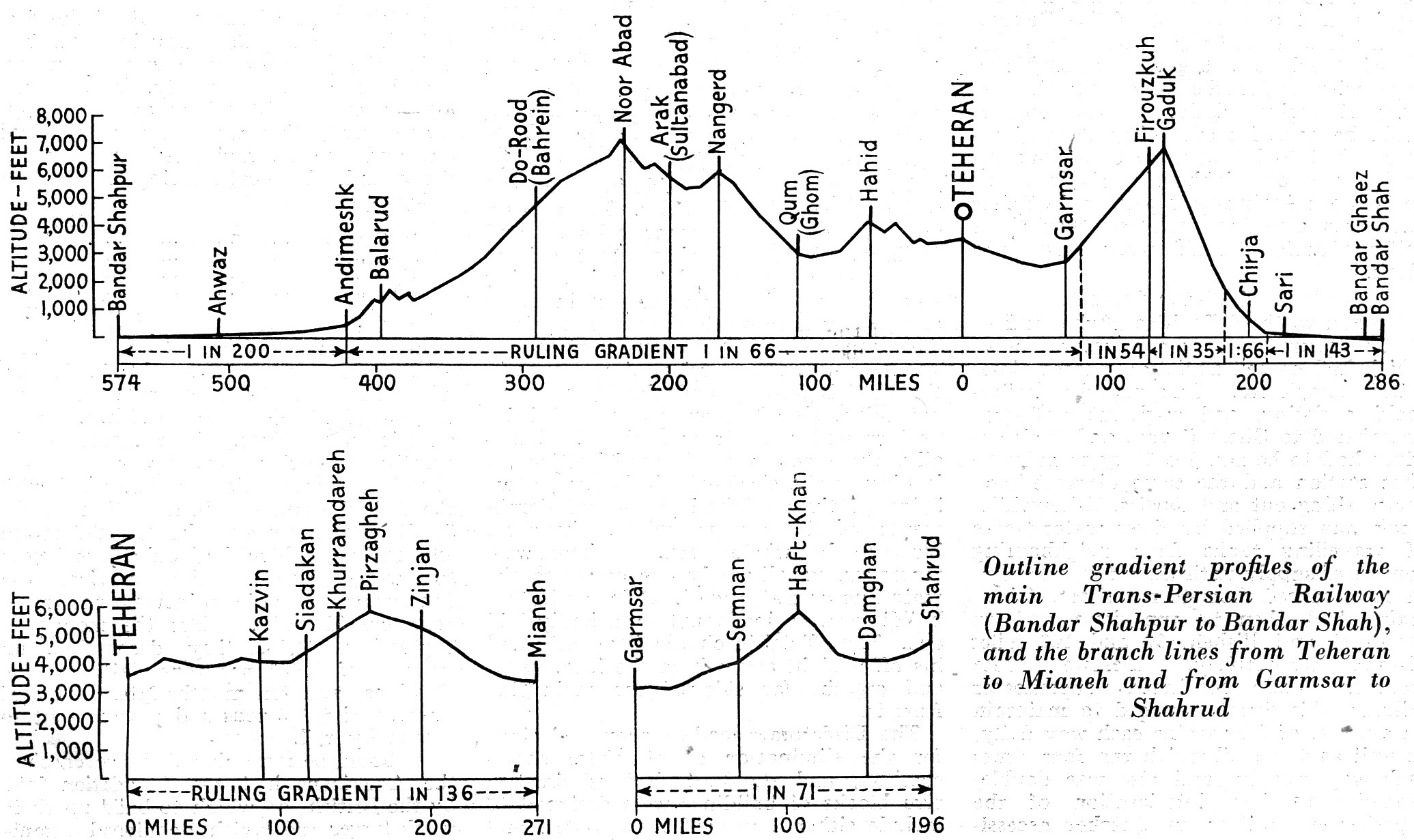
The Railways of Iran were to some great extent lost in the political turmoil. However, right at the end of the 1960s Iran Sate Railways sought additional diesel motive power from external suppliers. Delivery was taken of a number of power units in the very early 1970s. A further lot of locomotives was delivered in 1975. Wikipedia indicates that these locomotives were in three different lots: [14]

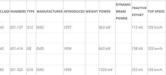
In 1970: 37 No. Hitachi HD10C Locomotives which had numbers within the range 601-638 in Iranian State Railways Class 40. They weighed 68 tons, were rated at 709 kW with a tractive effort of 122 kN and a top speed of 100 km/hr. [14] There are a few pictures of these locos in service in Iran on Flickr and http://www.farrail.com, including:

……………………….https://www.flickr.com/photos/alcoalbe/5380090479, ……………………….https://www.farrail.com/pages/touren-engl/Railways-in-Iran-2016.php, and ……………………….https://www.flickr.com/photos/alcoalbe/5382251132

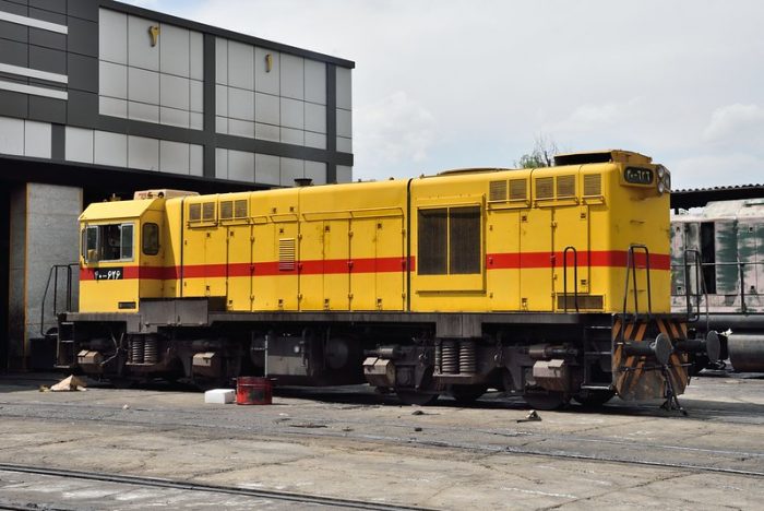
Typical of these power units in later life (c) blackthorne57 on Flickr (used under a Creative Commons Licence).  [15]
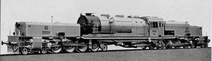
In 1971: 92 No. EMD-GT26CW Locomotives numbered 501-569, 801-914, 975-984 in Iranian State Railways Class 60. They weighed 120 tons, were rated at 2205 kW with a dynamic brake power of 1500 kW. They provided a tractive effort of 235 kN and a top speed of 123 km/hr. [14] There are some pictures of these locos on Flickr, including:

…………………….https://www.flickr.com/photos/alcoalbe/5115657564, …………………….https://www.flickr.com/photos/alcoalbe/5115655258, and …………………….https://www.flickr.com/photos/alcoalbe/5106973247.

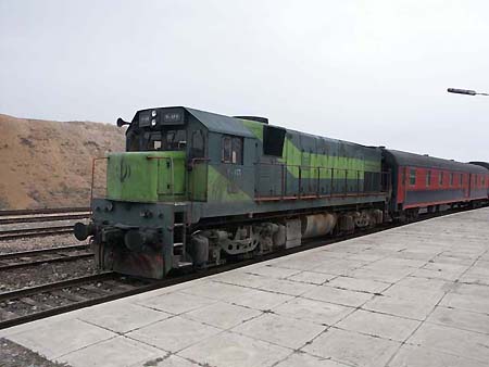
EMD-GT26CW Locomotive in 21st Century. [16]

In 1975: 41 No. EMD-G22W Locomotives which were numbered 138-178 in Iranian State Railways Class 40. They were rated at 1103KW with a tractive effort of 116 kN and a top speed of 105 km/hr. [14] A number of pictures of these locomotives are on the http://www.railpictures.net website and on Flickr. These include:

……………….https://www.railpictures.net/viewphoto.php?id=629929, ……………….https://www.railpictures.net/photo/577373, and ……………….https://www.flickr.com/photos/131021490@N02/27357570957.

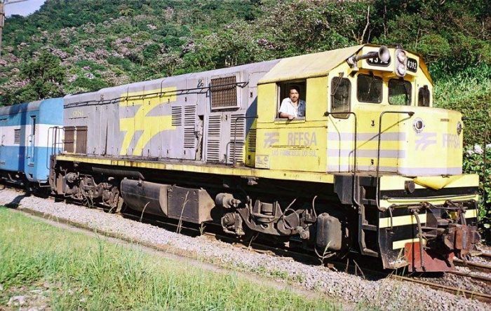
Not in Iran, but in Brazil, this picture of an EMD-G22 Locomotive has a Creative Commons Licence, (c) Heron Soares. The Locomotive is an EMD-G22U of Rede Ferroviária Federal S.A. MACOSA No. 4392-6L working on the Teresa Cristina Railroad – Paraná, Brazil. The suffix ‘U’ indicates narrow- rather than standard-gauge (which would have the suffix ‘W’). [17]

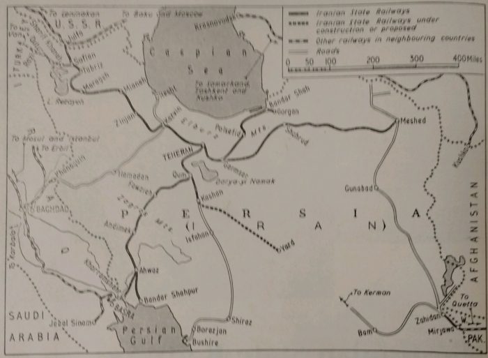
During the 1970s, the railways Iran remained under the control of Iran State Railways. A number of schemes to extend the railways were undertaken during this time. Wikipedia talks of the following schemes:

The length from Tabriz to Bazargan (192 km) which was started in 1912 was not finally completed until 1971. Please see the notes below as this date and destination need to be verified. The more southerly of the lines referred to in the section below was not completed until 1977. [31]

The length from Qom (Qum) to Zarand (847km) which was started in 1939 was not finally completed until 1971.

The length of line between Isfahan and Zarrin Shahr (111km) was started in 1969 and finished in 1972.

The length from Zarand to Kerman (80km) was not started until 1975 and was finished in 1979.

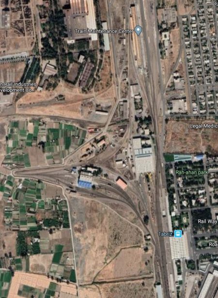
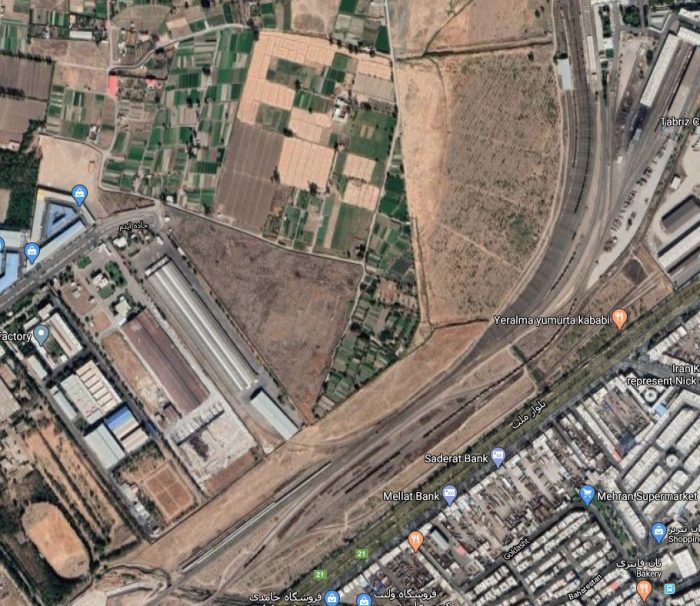
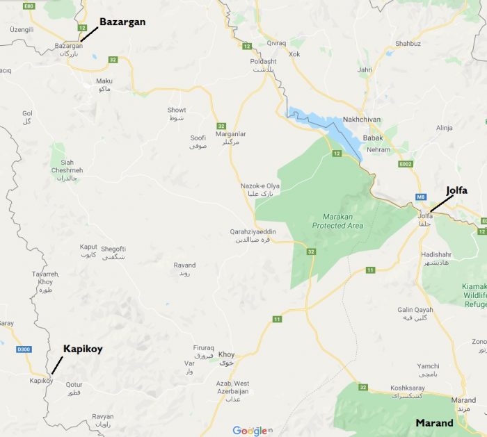
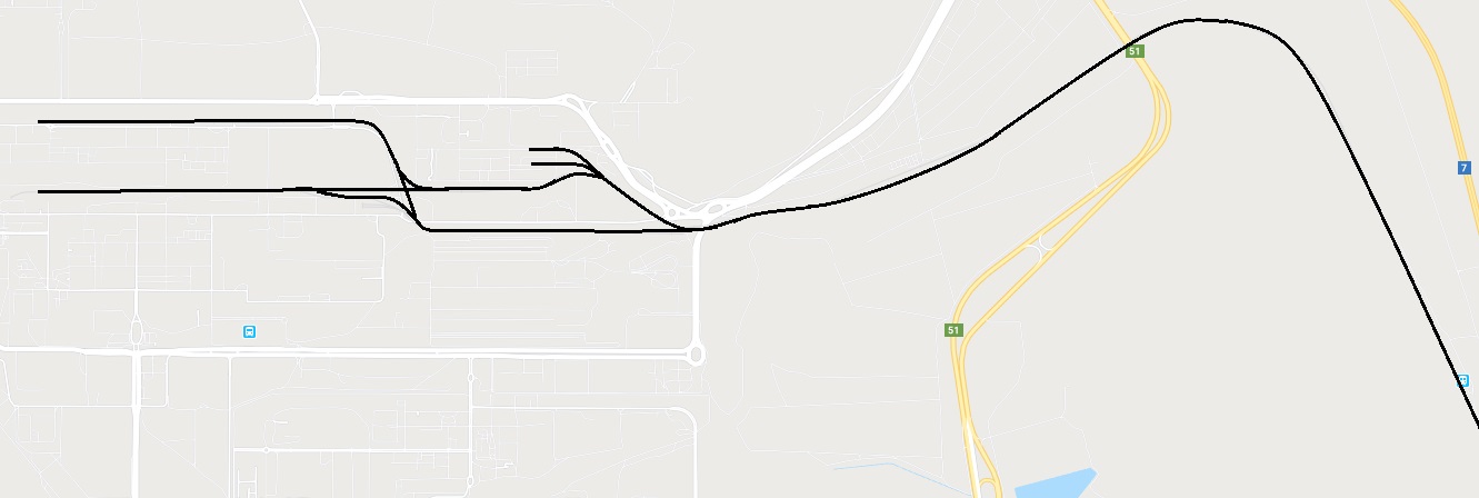
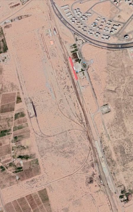
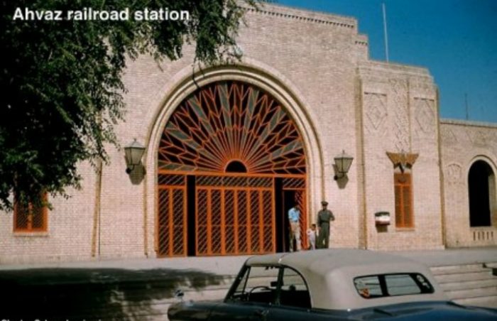
Tabriz to Bazargan: We noted the size of Tabriz in the second articles in this series. [18] Bazargan is a city in Maku County, West Azerbaijan Province, Iran. It is the most important Iranian ground border for importing and exporting. from Turkey In the 2006 census, its population was 9,047, in 2,126 families. [19][20] The railway station in Tabriz in 21st century is shown on the two adjacent satellite images (Google Earth). North of the station is the Railway Maintenance Centre. North of Tabriz the railway line becomes single track. The Railway line can be followed on Google Earth to Sahlan, where a Station serves a special economic zone. Northwest of Sahlan the railway passes under the Marand-Tabriz Road and runs parallel to it for some distance, alternately on its Southwest and Northeast sides and passing through a number of stations on the way.

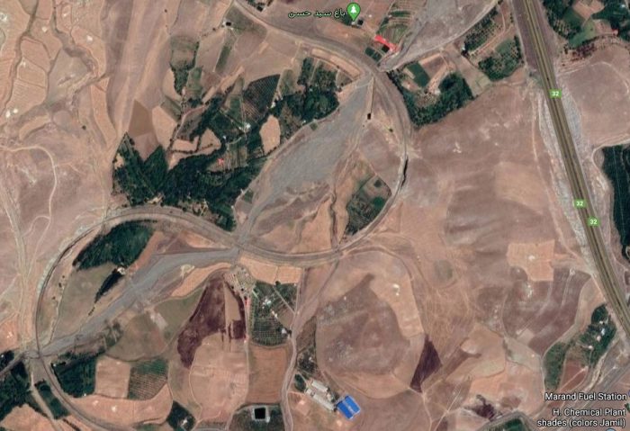
The railway divides to the West of Soufian. The more northerly route heads for Marand. Near Marand the highway begins to climb and the railway needs space in order to gain height. Two switchback curves provide room for the gradient to be kept manageable. These appear on the satellite image below.
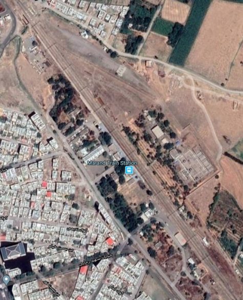
The railway then runs round the Eastern outskirts of the city of Marand to its railway station, sown on the adjacent satellite image. It then passes under the Marand-Hadishahr Road and parallel to the Marand-Jolfa Road. The line continues all the way to Jolfa and the border with Armenia and Azerbaijan.

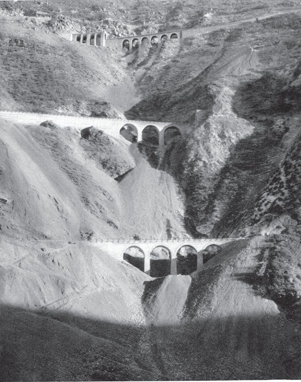
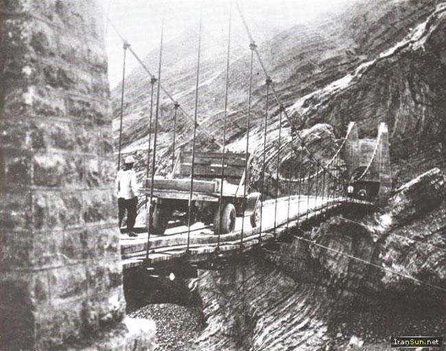
The more southerly route heads Southwest on the south side of Souflan, running roughly parallel to Route 14, through Dizaj Khalil Station and Sharafkhane Station and on into Iran’s West Azerbaijan Province. It travels on through Salamas, Yazdekan and through dramatic mountains to Razi and Kapikoy, crossing the Ghotour Bridge on the way.
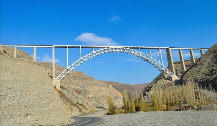
The Ghotour Bridge (Google Earth (c) Behzad Monajjemi, 2019)

I have followed both the lines above on Google Earth and looked at various online resources and cannot identify the route of a line between Tabriz and Bazargan. I am not sure, therefore which of these two routes the Wikipedia article relates to. The relative locations of the cities concerned are shown on the Google Maps extract below.

The line through Kapikoy and into Turkey extend to Vana dn is often referred to as the Van-Sufian Railway [30]

“The oldest segment of the railway dates back to the early 20th century, during World War I, when a 53 km (33 mi) branch railway was built from Sufian to Sharafkhaneh ” [30]

Wikipedia explains that ,”the construction of a railway to Iran, via Van, was approved on 15th June 1937. The railway would continue east from Diyarbakır to Van and to the Iranian border at Kapıköy. [31: p123] Construction began shortly after and the railway reached Kurtalan in 1940. Due to the mountainous terrain between Kurtalan and Tatvan, the route was changed and its western starting [point] became Elazığ. From Elazığ the railway would be built to Tatvan, via Muş, reaching Tuğ in 1964. [31: p174] A train ferry was established as a temporary means of transport between Tuğ and Van, as a bypass of Lake Van was planned. [31: p175] In the 1960s, Turkey and Iran came to an agreement to construct a railway from Van to Sharafkhaneh. The Van-Razi segment opened in 1971, while the Razi-Sharafkhaneh segment opened in 1977.” [30]

Isfahan to Zarrin Shahr: A 111km length of line was constructed between 1969 and 1972.  Isfahan is located 406 kilometres (252 miles) south of Tehran. It has a population of approximately 2.0 million, making it the third largest city in Iran after Tehran and Mashhad, but was once one of the largest cities in the world. [25][26]

Isfahan flourished from 1050 to 1722, particularly in the 16th and 17th centuries under the Safavid dynasty when it became the capital of Persia for the second time in its history under Shah Abbas the Great. Even today the city retains much of its past glory. It is famous for its Perso–Islamic architecture, grand boulevards, covered bridges, palaces, tiled mosques, and minarets. Isfahan also has many historical buildings, monuments, paintings and artefacts. The fame of Isfahan led to the Persian pun and proverb “Esfahān nesf-e- jahān ast”: Isfahan is half (of) the world.” [25][27]
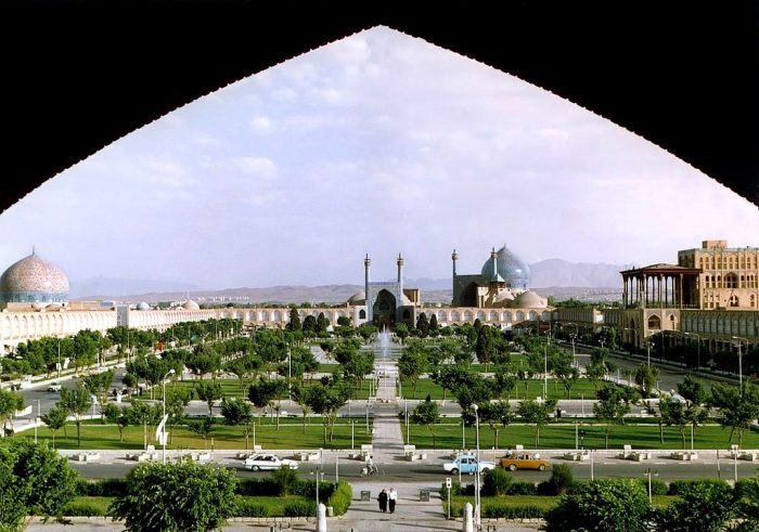
The Naghsh-e Jahan Square in Isfahan is one of the largest city squares in the world, (c) Arad Mojtahedi, used under a Creative Commons Licence. [25]
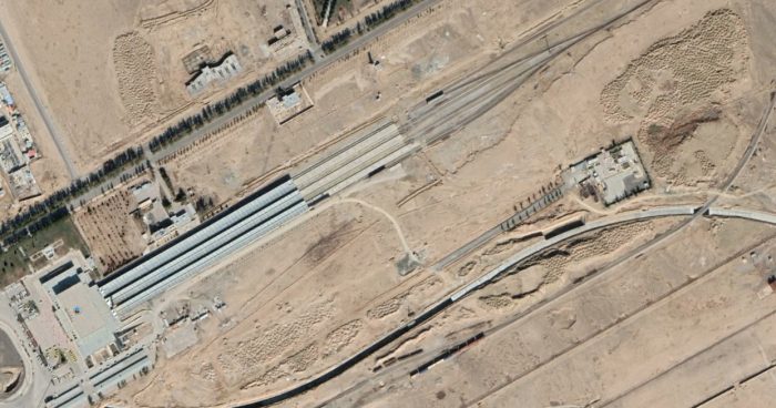
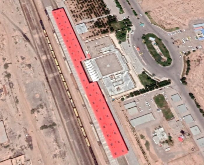
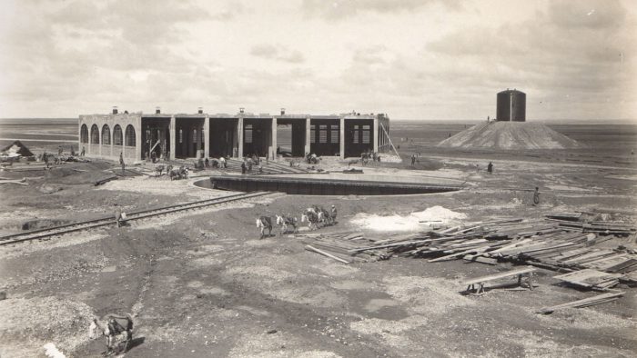
The modern, 21st century, Isfahan Station is some distance (15km) outside the city to the South (Google Earth).
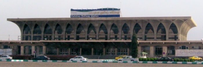
Isfahan Railway Station. [28]
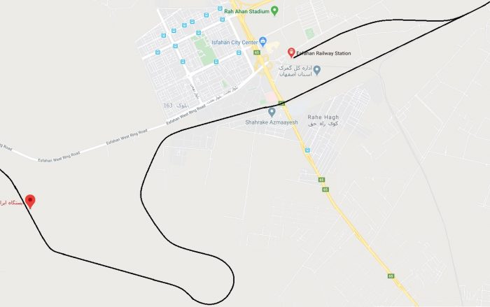
Isfahan Railway Station is shown in the top right of this Google Maps extract. Trains to Zarrin Shahr left travelling East and then reversed to head Southwest. The topography dictated that the line  had to loop around in order to allow trains to negotiate significant differences in height. The distance between the two cities by road (along Route 51) is only 47km. The railway is 11km in length!
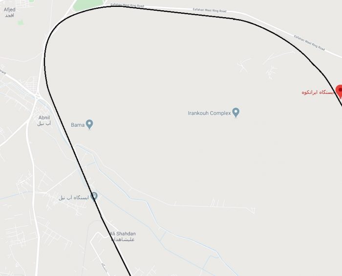
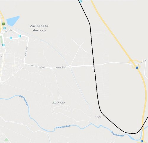
The route to Zarrin Shahr was a branch line which served an industrial complex on the North side of the city of Zarrin Shahr.

The station was to the Northeast of the city. It can just be seen at the top of the adjacent Google Maps excerpt.Zarrin Shahr is, as of the 2006 census, a city with a population of 55,984, in 15,154 families. [20] In the past 30 years people, from various parts of Iran have moved to Zarrin Shahr to work in the nearby steel mill [29] which is served by the railway and sited to the North of the city.

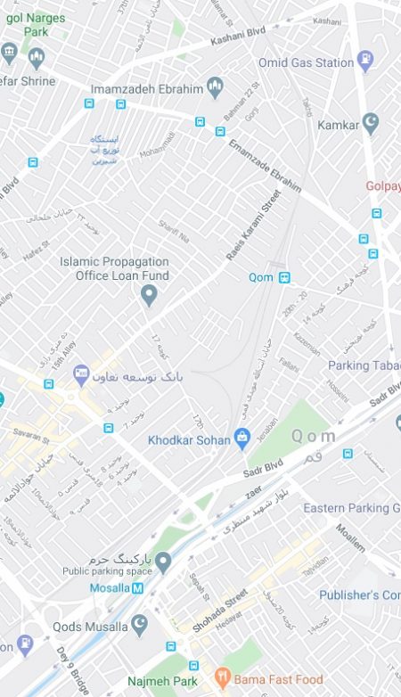
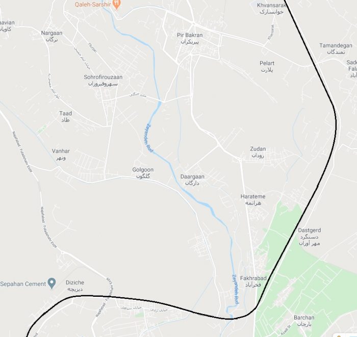
Qom (Qum) to Zarland: This is a significant long-distance route.

Earlier in this series of articles we provided a Satellite Image of Qom (Qum) Railway Station. [18]. The adjacent Google Maps extract shows the station site. The line to the North of the station heads for Tehran. South of the station there is a junction to the Northwest of the Mosalla Metro Station. The line heading Southwest runs towards Arak and the South, and that turning to the Southeast heads for Yazd and Zarand. The line to Zarand was close to 850km long!

Yazd was encountered first around 500 km from Qum.
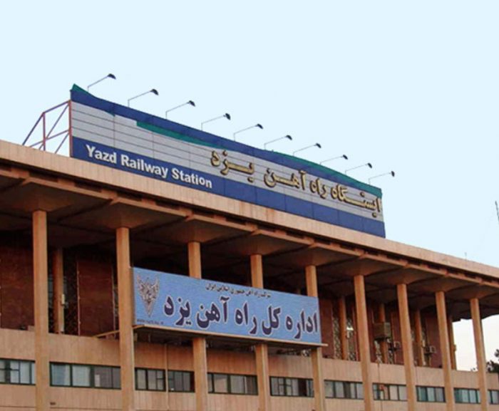
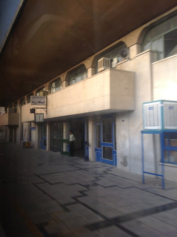
Yazd Railway Station Building in the 21st century, (c) Hamid Khorshidi on Google Maps.
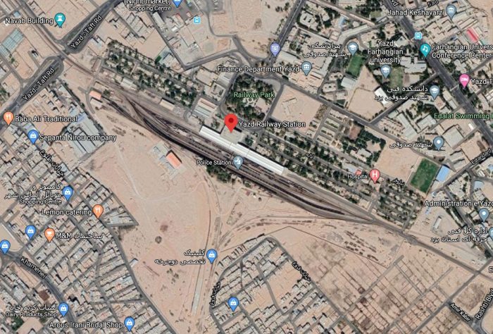
Yazd Railway Station in the 21st century (Google Earth).
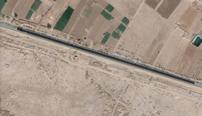
A large mineral train travelling between Zarand and Yazd, captured in the 21st century on the satellite imagery from Google Earth.

Zarand is a city of more than 54,000 people in the early 21st century. [20] It is also home to the Zarand Iranian Steel Company (ZISCO). [22] ZISCO was established in 2008. [23]

Zarand Railway Station. [24]
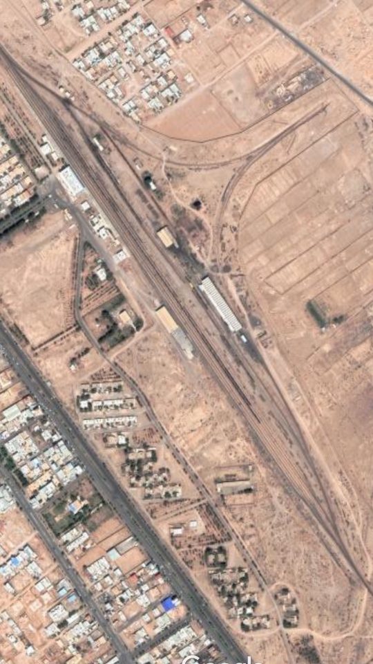
Zarand Railway Station (Google Earth).

Zarand to Kerman: The extension of the line from Qom to Zarand to the provincial capital city of Kerman was complete in 1979. The route was direct across relatively open plains. 
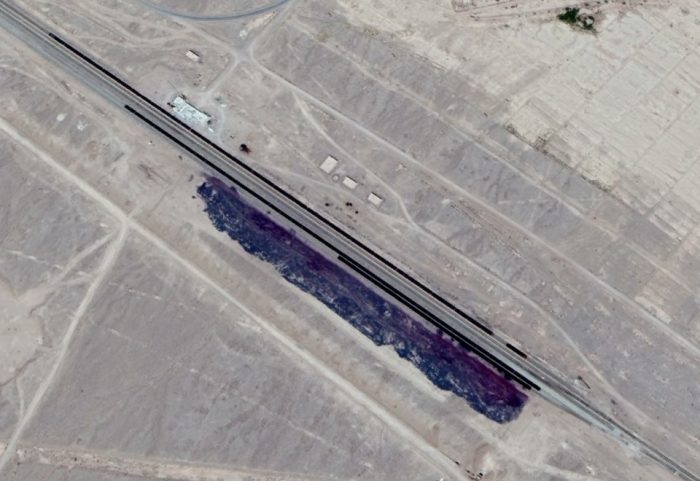
These appear to be either coal of iron ore sidings parallel to the main line between Zarand and Kerman. The strong black lines visible on the satellite image are long trains of open wagons in what appear to be exchange sidings (Google Earth).
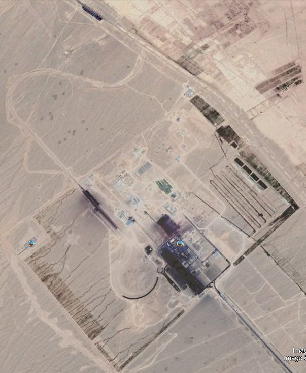
This satellite image shows the exchange sidings highlighted on the previous image alongside the main Zarand to Kerman line in the top left of the image. A branch line which serves the min complex in the centre of the image can be seen curving away from the main line and leading a complex of sidings to the Southwest side of the mining site (Google Earth) .
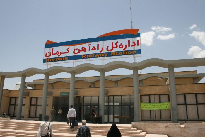
Kerma Railway Station, taken on 13th June 2009 (c) Teekkari, used under a Creative Commons Licence. The station is to the Southwest of the city and a little distance beyond the outskirts of the city. [32][33]
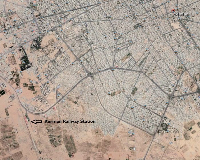
Kerman Railway Station is to the Southwest of the city (Google Earth). It is shown in gradually increasing detail on these three satellite images.

At the 2006 census, Kerman’s population was 821,394, in 221,389 households, making it the 10th most populous city of Iran.[20]

Wikipedia comments: “Kerman is … the most important city in the southeast of Iran. It is also one of the largest cities of Iran in terms of area. Kerman is famous for its long history and strong cultural heritage. The city is home to many historic mosques and Zoroastrian fire temples.

Railway development in Iran has continued apace from the 1980s through to the early 21 century. I hope to cover more about about these more recent developments in further posts.

References

  1. https://www.railway-technology.com/projects/northsouthtransnatio, accessed on 25th March 2020.
  2. https://en.wikipedia.org/wiki/Iranian_Revolution, accessed on 28th March 2020.
  3. Ervand Abrahamian; Iran between two revolutions. Princeton University Press; 1982, p515.
  4. Gholam-Reza Afkhami; The Life and Times of the Shah; 12th January 2009, University of California Press.
  5. Ervand Abrahamian; Mass Protests in the Islamic Revolution, 1977–79; in Adam Roberts and Timothy Garton Ash (eds.), Civil Resistance and Power Politics: The Experience of Non-violent Action from Gandhi to the Present; Oxford University Press, Oxford & New York, 2009, p162–78.
  6. Roy Mottahedeh; The Mantle of the Prophet: Religion and Politics in Iran; One World Publications, 2004, p375.
  7. http://www.fsmitha.com/h2/ch29ir.html, accessed on 28th March 2020.
  8. Robin Wright; The Last Great Revolution: Turmoil And Transformation in Iran; Alfred A. Knopf: distributed by Random House, 2000, p. 220. Read on https://archive.org/details/lastgreatrevolut00wrig/page/220, accessed on 28th March 2020.
  9. Robert Graham; Iran, the Illusion of Power; St. Martin’s Press, 1980.
  10. James L. Gelvin, The Modern Middle East – Second Edition; Oxford University Press, Oxford, 2008, p. 285.
  11. Baqer Moin; Khomeini: Life of the Ayatollah; Thomas Dunne Books, 2000.
  12. Olmo Gölz; Dah Šab – Zehn Literaturabende in Teheran 1977: Der Kampf um das Monopol literarischer Legitimität;  Die Welt des Islams Volume 55, No. 1, 2015, p83–111.
  13. Amir Taheri; The Spirit of Allah; Adler & Adler, Newbury Park, CA, 1985.
  14. https://en.wikipedia.org/wiki/List_of_stock_used_by_railways_in_Iran, accessed on 22nd March 2020.
  15. https://www.flickr.com/photos/laversentertainers/31277206921/in/photostream, accessed on 25th March 2020.
  16. https://www.trains-worldexpresses.com/300/306.htm, accessed on 28th March 2020.
  17. https://en.wikipedia.org/wiki/History_of_rail_transport_in_Iran#Railway_construction%5B3%5D, accessed on 28th March 2020.
  18. https://rogerfarnworth.com/2020/03/24/railways-in-iran-part-2-the-1910-to-1945, published in March 2020.
  19. https://en.wikipedia.org/wiki/Bazargan,_Iran, accessed on 28th March 2020.
  20. Census of the Islamic Republic of Iran, 1385 (2006); Islamic Republic of Iran. Archived from the original (Excel) on 11th November 2011 and quoted by Wikipedia in reference 19 above and 21 below.
  21. https://en.m.wikipedia.org/wiki/Zarand,_Iran, accessed on 28th March 2020.
  22. https://m.facebook.com/pages/Zarand-Iranian-Steel-Company/214051678754211, accessed on 28th March 2020.
  23. https://www.hoofd-nek-rug-bekken-pijn.nl/1/4125-Zisco-Iron-Ore-Mine.html, accessed on 28th March 2020.
  24. https://it.foursquare.com/v/%D8%A7%DB%8C%D8%B3%D8%AA%DA%AF%D8%A7%D9%87-%D8%B1%D8%A7%D9%87%D8%A2%D9%87%D9%86-%D8%B2%D8%B1%D9%86%D8%AF–zarand-railway-station/51d0dacc498eb3887a444479, accessed on 28th March 2020.
  25. https://en.wikipedia.org/wiki/Isfahan, accessed on 29th March 2020.
  26. http://worldpopulationreview.com/countries/iran-population/cities, accessed on 29th March 2020.
  27. Robin McKown; Isfahan Is Half The WorldNew York Times: 2nd November 1975; https://www.nytimes.com/1975/11/02/archives/isfahan-is-half-the-world-isfahan-is-half-the-world.html, accessed on 29th March 2020.
  28. https://www.iranrail.net/stations.php, accessed on 29th March 2020.
  29. https://en.wikipedia.org/wiki/Zarrin_Shahr, accessed on 30th March 2020.
  30. https://en.wikipedia.org/wiki/Van-Sufian_railway, accessed on 30th March 2020.
  31. Efdal As; Cumhuriyet Dönemi Ulaşım Politikaları (1923-1960) (in Turkish); Atatürk Araştırma Merkezi, Ankara; 2013, quoted in reference 30 immediately above.
  32. https://erasmusu.com/en/erasmus-iran/erasmus-blog/discovering-iran-kerman-city-pt-1-501432, accessed on 30th March 2020.
  33. https://it.wikipedia.org/wiki/File:Kerman_Railway_Station.jpg accessed on 30th March 2020.

Railways of the Great War: Book Review

The Railways of the Great War by Colette Hooper (with Michael Portillo)

Published by Bantam Press, London, 2014.

ISBN: 9780593074121

I am enjoying catching up on reading a number of books as part of being in lock-down. This book can now be bought relatively cheaply. I got my copy for less than the price of one of the railway magazines available in newsagents in the Spring of 2020.

When Michael Portillo’s railway television programmes based on Bradshaw’s Guide first appeared on the BBC I was delighted and avidly watched, perhaps, the first 10 series. As time has gone by, the format has gradually become less attractive. For me, this is because, the focus was never quite as dedicated to the railways as I had hoped and used the railways as a convenient way if linking a series of short video articles about life in general.Servicemen on their way to war. [2: p59]

What has delighted me about Colette Hooper’s book is that it is unashamedly railway focussed. The dustjacket says: From the exploits of railwaymen at the Front to the secrets of railway spies who worked behind enemy lines; the manufacture of munitions in railway workshops to the role of railways in post-war remembrance – this book explores some of the remarkable stories of the railway war. Individually, each illuminates a different aspect of the conflict. Taken together, they provide us with a fresh perspective on the First World War as a whole.” [1]

Michael Portillo provides a forward to the book and appears occasionally in photographs throughout the text but otherwise his input into the book is minimal. The text appears to be Collette Hooper’s work. She is a television producer who specialises in social history and has been closely associated with BBC Two’s highly successful Great British and Great Continental Railway Journeys franchise since 2010. “She worked with the production team to develop ‘Railways of the Great War with Michael Portillo’, going on to edit much if the series. Colette studied History at Oxford University, with a focus on Early Modern Britain and Europe.” [1]

Collette Hooper has authored an excellent study on the role of railways in the First World War. “Railways helped to precipitate this mechanised conflict: they defined how it was fought and kept the home front moving; they conveyed millions to the trenches and evacuated the huge numbers of wounded. The railways sustained a terrible war of attrition and, ultimately, bore witness to its end.” [1]

Michael Portillo, writing in 2014 said: “A century on from the outbreak of the First World War, historians and the public are trying to understand it’s causes and it’s course better. I for one had never realised until now that it was a railway war. Grasping that helps us to appreciate how commanders planned offensives and defined objectives. The general who did not grasp logistics was headed for defeat. Britain was heading in that direction until it tackled the shell crisis of 1915 and the bottlenecks on the railways in France and Belgium the following year.” [2: p12]

Chapter headings are:

  1. A Railway War Begins.
  2. Rising to the Challenge.
  3. Keeping the War Moving.
  4. On Track to Victory.
  5. Railways and Remembrance.

A comprehensive bibliography and index support a better understanding of the subjects covered and help with navigation around the text.The National Railway Museum provides an excellent resource. This picture comes from their site. Ambulance trains were a very important contribution made by the railways to the war effort. Colette Hooper spends some pages in The Railways of the Great War describing this vital work. [2: p8, 79-84][3]

There are also a few delightful and/or important asides within the book. These include:

The Bath Railway Poet. [2: p134ff]

Free Station Canteens. [2: p138ff]

Quintinshill – The Worst Railway Disaster in British History. [2: p140ff]

Espionage – Trainspotting with a Purpose. [2: p164ff]

Perhaps one of the more significant short sections of the book is that devoted to the importance of the role of women in the conflict. [2: p150-158]

Overall, this book well worth the time it takes to read. It concludes with a couple of pages entitled: “Lessons of the Railway War.” [2:H p224-225] Hooper highlights how victory depended on logistics just as much as on military might. She asserts that “the dynamism injected by the railways gave rise to a paradox. The technology that facilitated the rapid projection of military might across vast distances in a matter of hours simultaneously served as the conflict’s ball and chain. The railways carried vast quantities of men and materiel to the front line with dazzling efficiency – but only as far as the railheads. For either side to advance, the attacking force … had to leave the tracks behind, cutting themselves off from their supply chain, while the defending side could use the rails to bring in reinforcements, strengthening their ability to repel the attack. By favouring the defensive, railway age technology perpetuated the stalemate. For both sides, the tracks became the trammels that imprisoned them in their dugouts, feeding a seemingly interminable war if attrition.” [2: p224]

Finally, she says, “The railways were the backdrop to the every day experience of war, and today perhaps they can serve to connect us to this chapter in our history. As we travel the same tracks and pass through the same stations … we can try to enter into the mindset of those who lived through the dark days of the First World War.” [2: p225]

References

  1. Frontispiece and Dustjacket of Collette Hooper; Railways of the Great War with Michael Portillo; Bantam Press, London, 2014.
  2. Collette Hooper; Railways of the Great War with Michael Portillo; Bantam Press, London, 2014.
  3. https://www.railwaymuseum.org.uk/objects-and-stories/ambulance-trains-bringing-first-world-war-home, accessed on 30th March 2020.


Railways in Iran – Part 3 – 1945 to the 1960s

In June 1945, shortly after the end of the War in Europe, “the allied military authorities returned the operating responsibility for the Trans-Iranian Railway to the Iranian Government. The line and its equipment were in a very run-down condition due to the hard usage received, and recovery took some years.” [1: p24]

The Cambridge History of Iran – Volume 1, which was published in 1968 says that after shortages disappeared a pattern became established, and by 1968, railways provided the basic freight-transport service from the Persian Gulf ports to Tehran and the eastern Caspian Sea region. The authors said, “Branch lines have been extended to Tabriz and Mashhad (Meshed), mitigating to a high degree the relative decline of these cities since 1925. A 120 mile westward extension of the railway line from Tabriz, now being built under the sponsorship of the Central Treaty Organization, will connect the Iranian and Turkish railways. (It was completed between Tehran and Tabriz by 1960.) An eastward extension from Qum, south of Tehran, is now complete as far as Yazd (but not by 1961 when Baker visited) and will ultimately connect with the Pakistan railway system in Baluchistan. During World War I a line of this system (then part of India) was extended as far as Zahidin in Iran, a short distance from the border. Service to Zahidin is provided by Pakistan National Railways, but there is no regular schedule.” [10: p559] The line when built was 5ft. 6in. gauge.

Because of shortages after the War, the parlous state of the network and the political/economic difficulties of the country arising out of the nationalisation of the Anglo Iranian Oil Company, “it was not until the mid-1950s that the railway system again began to grow significantly. After the completion of the Trans-Iranian Railway in 1938, Reza Shah launched the construction of lines from Teheran, 461 miles northwest to Tabriz, second city of Iran and capital of Azerbaijan province, and 575 miles to Meshed in the north-east, fourth city of the country in size and its most holy place of pilgrimage.” [1: p24]

It was planned to complete the Meshed line, which branches from the Trans-Iranian at Garmsar, 71 miles south-east of Tehran, in 1943, but the war brought construction to a halt in 1942. By this time the line was open to Shahrud, 267 miles from Tehran. Work on the Tabriz line, which was scheduled for completion in 1944, was likewise brought to a halt after it had reached Mianeh, 273 miles from the capital, and construction on both lines was not resumed for more than a decade. In April 1957, however, the line to Meshed was opened, followed a year later by that to Tabriz.

M.H. Baker says that rebuilding to “4 ft. 8½ in. gauge, of the line from Tabriz to Jolfa, and the branch to Sharif Khaneh, was also completed in 1958. These lines had been handed over to Iranian control by the Soviet Union shortly after Shah Reza’s coup d’etat” [1: p24] in the 1920s.

Baker was writing in the early 1960s. At that time he said that construction was “now under way of a line from Sharif Khaneh via Khoi and Qutur to Razi on the Turkish frontier where it is hoped to effect a junction with an extension of the Turkish railways. The connection with the railway system of Europe which this will create may prove of great economic benefit to Iran as it will be possible to carry exports and imports to and from Europe far more speedily than by the very circuitous sea route around the south of Arabia.” [1: p24]

He continued: “Likely to be of less importance, is a proposed link-up with the railway system of the Indian sub-continent. The immediate project is for a line from Qum on the Trans-Iranian Railway, 112 miles south of Teheran, through Kashan to Yazd with a branch to Isfahan. Work had already begun on the Qum-Yazd section (295 miles) in 1938 but was interrupted by the war. The earthworks were practically complete however, and it was possible to start laying track from Qum to Kashan in 1947, and this 61-mile stretch was opened in 1949. In 1959, construction onwards to Yazd was started. It is proposed ultimately to carry then line to Zahidan in the southeast,” [1:p24] where is would connect with the line from Quetta which we remarked on in the second article in this series.

The Trans-Iranian Railway was extended from Bandar Shah to Gorgan in 1961. [4][7] During the land reforms implemented by Mohammad Reza Shah in 1963 as part of the “White Revolution” the Trans-Iranian Railway was [also] extended to link Tehran to Mashhad, Tabriz, and Isfahan. [5][6: p133]The Railway Magazine carried this map of Iran’s railways in January 1963. [1: p22]

Line
Length in km
Construction period
Teheran – Ray (1.000 mm)
9
1886 – 1888
Tabriz – Jolfa (1.524 mm, now 1.435 mm, 1975 electrified) (– Armenia)
148
1912 – 1916
Zahedan – Mirjaveh (1.676 mm) (– Pakistan)
93
1920 – 1921
Tehran – Bandar Shah (all following lines: 1.435 mm)
461
1927 – 1937
Tehran – Bandar Shahpur
928
1927 – 1938
Ahvaz – Khorramshahr
121
1942 – 1943
Sar Bandar – Mahshahr
12
1950 – 1951
Garmsar – Mashhad (Meshed)
812
1938 – 1958
Tehran – Tabriz
736
1939 – 1959
Gorgan – Bandar Shah
35
1960 – 1961
This table summarises developments in the network in Iran up until the 1960s [9]

Iranian State Railway Garratt. 418 – 421 (BP 6787-6790/1936) later renumbered 86.01 – 86.04. Built by Beyer-Garratt. [12]Iranian State Railways 2-10-2 Locomotive. [8][11]These Vulcan Foundry built 2-10-2 ‘Decapod’ locomotives were supplied in two batches, 40 in 1952 and 24 in 1954. [8][11]

British-built Steam was a feature of this period in the history of the network in Iran and was dominant until the late 1950s. [19] There will be more about the motive power on the network in a future article. The two pictures above give an idea of the necessary power of the locomotives used on the steep grades of the Trans-Iranian Railway. Those grades were as steep as 1 in 35.The Railway Gazette of February 1945 illustrates the gradient profile of the three lines referred to above. [18: p159]

Steam was not the only form of motive power. Diesel propulsion was introduced by the Americans during the Second World War and performed particularly well on the steep grades of the southern section of the Trans-Iranian Railway. However, the ALCO RCD-1 locomotives used during the war were all shipped back to the USA once the conflict was over. [14][15][16][17]

For a time, the network was again served by steam but as the 1950s progressed diesel power began to be sought out. [19] Wikipedia highlights the following units in use in the late 1950s all manufactured by Electro-Motive Diesel in the States. Full details are not provided and in its list of diesel power it makes no reference to the power units which were brought into Iran during the Second World War which it appears all were exported back to the USA. ….. [13]

The network, by the late 1950s was being run by the Iranian State Railway Company. The Cambridge History of Iran – Volume 1, says that the country had, in all, “2,300 route miles of railway, 120 steam and 252 diesel locomotives, 378 passenger coaches, 27 dining-cars and 5,762 freight-cars of all types. Employees numbered over 36,000; the total volume of freight carried was 334,000 tons, and there were about four and a half million passengers.” [10: p560]

The 252 diesel locomotive mentioned in the paragraph immediately above include the 171 tabulated above. In addition to those tabulated, there were a number of locomotives supplied by Electroputere/Sulzer in 1959. There were a number of older 0-4-0 diesels which had been in country prior to the War.

I have only been able to find pictures of one of the Electroputere/Sluzer locomotives which ran in Iran and they are on Flickr. Two pictures show the loco. They can be found on the following links:

……….https://www.flickr.com/photos/alcoalbe/5381331217

……….https://www.flickr.com/photos/alcoalbe/5381331229

The Sulzer website has three pictures of a pair of this class of locomotives which were sent to Iran for trials. [23]One of three views of a pair of 060 DA’s led by 0518 that were sent for testing in Iran. All three pictures can be seen on the Derby Sulzer Website All three views were taken at the town of Arak. (c)  F Burdubus. [23] 

Electroputere S.A. was a company based in Craiova, Romania. Founded in 1949, it was one of the largest industrial companies in Romania. “Electroputere has produced more than 2,400 diesel locomotives, and 1,050 electric locomotives for the Romanian, Bulgarian, Chinese, and Polish railways” [21] and seems also to have produced a number of units for Iran. The company is still a significant economic presence in Romania. [22]

The country’s railway service was, at that time, supplemented by, and suffered severe competition from, road transport. There were “considerable restrictions on the types of cargoes lorries may carry on the routes running parallel with the railway. Railway freight traffic also suffered from the construction of petroleum-product pipelines from Khuzistan to Tehran and Mashhad, which eliminated its most important cargoes; and the completion of a refinery in Tehran in 1966 … removed most of the railway’s transport of fuel-oil.” [10: p560]

We will look at the 2ft. 6in. narrow-gauge railway system which supplied the Agha Jari oilfied from Bandar Shapur on another occasion.

Into the 1960s, the number of diesel locomotives remained relatively constant. Wikipedia lists only 2 No. new EMD  locomotives – EMD-G18W locomotives – which arrived in 1968. [13] The ‘W’ suffix relates to the fact that these locos were built for standard-gauge lines (a ‘U’ would designate narrow-gauge). [20]

As we noted above some railway construction continued in the 1960s – specifically the line from Qum to Yazd.

The next article in this series will look at the period from the 1970s onwards.

References

  1. M.H. Baker; The Iranian State Railways; in The Railway Magazine, January 1963.
  2. https://rogerfarnworth.com/2020/03/23/railways-in-iran-part-1-tehran-to-rey-1888, published 23rd March 2020.
  3. https://rogerfarnworth.com/2020/03/24/railways-in-iran-part-2-the-1910-to-1945, published 24th March 2020.
  4. https://en.wikipedia.org/wiki/Trans-Iranian_Railway, accessed on 22nd March 2020.
  5. https://kavehfarrokh.com/uncategorized/a-short-history-of-the-iranian-railway-system, accessed on 22nd March 2020.
  6. Ervand Abrahamian; A History of Modern Iran; Cambridge University Press, Cambridge, 2008.
  7. X. De Planhol;  Bandar-e Šāh;,Encyclopaedia IranicaIII. 1988, p688–689 – http://www.iranicaonline.org/articles/bandar-e-sah, accessed on 25th March 2020.
  8. Beyer Peacock Locomotive Order List, Garratt Locomotives, Customer List V1, (PDF); BeyerPeacock.co.uk. 2002-04-08, acccessed on 26th March 2020.
  9. https://www.farrail.com/pages/touren-engl/Railways-in-Iran-2016.php, accessed on 25th March 2020.
  10. W. B. Fisher, William Bayne Fisher, John Andrew Boyle, Ilya Gershevitch (eds); The Cambridge History of Iran – Volume 1; Cambridge University Press, Cambridge, 1968.
  11. http://enuii.com/vulcan_foundry/photographs/pictorial_loco_list.htm, accessed on 25th March 2020.
  12. http://www.beyergarrattlocos.co.uk/pics5.html, accessed on 25th March 2020.
  13. https://en.wikipedia.org/wiki/List_of_stock_used_by_railways_in_Iran#cite_note-rfe-2, accessed on 26th March 2020.
  14. https://en.wikipedia.org/wiki/Persian_Corridor, accessed on 26th March 2020.
  15. https://www.historynet.com/the-battle-before-the-battle.htm, accessed on 26th March 2020.
  16. https://en.wikipedia.org/wiki/ALCO_RSD-1, accessed on 26th March 2020.
  17. https://transportation.army.mil/museum/AOTM/aotm-august-2018.html, accessed on 26th March 2020.
  18. British Work on Persian Railways, 1942 – Parts 1 and 2; The Railway Gazette, 2nd and 16th February 1945, p111-114 and p159-162.
  19. https://iranrails.com/description/17/Iran-railway-locomotives, accessed on 27th March 2020.
  20. https://en.wikipedia.org/wiki/EMD_G18, accessed on 27th March 2020.
  21. https://www.wikiwand.com/en/Electroputere, accessed on 27th March 2020.
  22. https://www.electroputere.ro/en, accessed on 27th March 2020.
  23. https://www.derbysulzers.com/cfr2100.html, accessed on 27th March 2020.


John 11: 1-45; Ezekiel 37: 1-14; Romans 8: 6-11. Love

How do you feel about the future? Optimistic? Pessimistic? What fills you mind as you think about the next few years?

Can you look forward with hope at this most difficult time for the whole human race? Does Coronavirus fill you heart with fear?

What about the future of the Church?

It is easy to feel despondent. We’ve been told time and again that numbers attending churches are dropping, that the church is no longer relevant. The evidence seems to support a general air of despondency. And at times many of us will have wondered whether there is any point carrying on coming to church.

I’ve heard people saying things like: “It’s dry and musty, it’s not my kind of thing, it’s just like a bag of old bones – no life there at all. Why would I want to come to church?”

And yet for others of us, Church does not feel that way at all. Somehow God has reached out and touched us through the worship. Sometimes there is a tingling inside us when we think about coming to worship – and we say that coming to church seems to give our life a sense of purpose. We have hope for the future again.

For others, the presence of the church in the midst of life is so very important. It is the bastion against all that threatens to pull us down. It is the one constant in a shifting world, a place we can always turn to in an hour of need. And this current time, with the threat of disease hanging over us, is just such a time.

The readings set for Passion Sunday are long. But they clearly have one theme in common. New life breathed into dead bodies. It was obvious in Ezekiel, just as obvious in the raising of Lazarus. Both these readings have a sense of hope and life.

Both in Ezekiel and in the story of Lazarus the seemingly impossible happens. In Ezekiel’s case it is in a vision, in Lazarus’ case the story asks us to accept that he was raised by Jesus. Both are saying to us in their own way that the seemingly impossible is possible with God. God can even raise the dead! Ezekiel wants his hearers to believe again that defeated, hopeless Old Testament Israel can again be a living, dynamic force.

And Ezekiel’s vision was taken up as a primary rallying point for black slaves in America. “…Dem bones, dem bones, dem dry bones … hear the word of the Lord.”

And as generations past, hopelessness was transformed into belief and action. The slave trade was abolished and later, the sporting success of a person like Jesse Owen brought dignity and hope to black people. And people like Dr. Martin Luther King took on the establishment and brought an end to official discrimination.

Hope rose from the ashes of despair.

There have been other instances in the history of the world where darkness is defeated. The fall of communism and the downfall of the Berlin Wall in 1989, the end of apartheid in South Africa in the 1990s.

And in our Gospel reading Jesus speaks into a tomb and raises Lazarus, prefiguring his own resurrection which was to take place only a few months later. Martha clearly believed in the resurrection, but for her it was something remote, something which would only happen come judgement day. …  Jesus wanted her to have hope now, hope for the present and the immediate future – and so he raises Lazarus.

It would be so easy for us to relegate hope and hopefulness to the hereafter. So easy for us to think that our faith only really works as we look beyond death and pray that God will accept us home to heaven. But ‘life to mortal bodies’ isn’t just for heaven. Life and hope are for now as well as for the future.

Just as in Ashton-under-Lyne we saw, 12 years ago, a new market rise from the ashes of the old – like a Phoenix. Jesus wants us to believe that he can through his Spirit breath new life into us as individuals and new life into our churches. We might feel small and insignificant, we might feel hopeless. But our bible readings talk of God’s Spirit energising and strengthening us.

All Lazarus had to do was respond – he could have stayed in the tomb, but he chose to come out into the light. Ultimately, all we have to do is to respond to what we see God doing in our churches and in our wider communities.

No doubt the signs of new growth will be fragile. They will need tending and caring for, they might even seem small and insignificant. But God’s Spirit is at work, we need to feel his breath inside us and respond, like Lazarus walking out into the light.

“If the Spirit of him who raised Jesus from the dead dwells in you,” says Paul in Romans, “he who raised Christ from the dead will give life to your mortal bodies also through his Spirit that dwells in you.” (Romans 8: 11)

This is the theme of all of the lectionary readings set for this Sunday. … God’s life can and does reinvigorate our lives.

Railways in Iran – Part 2 – 1910 to 1945

I have been reading old copies of the Railway Magazine from the 1950s and 1960s. The old small format magazines somehow seem more attractive than the glossy larger format modern magazines, perhaps that is a sign of ageing on my part!

In the January 1963 edition of the magazine there is a long article about the railways of Iran which is based on a visit in 1961 to Iran by M.H. Baker MA. [1] I have already posted an article, based on Baker’s visit, about the first railway in Iran – a short 5.5 mile long line from Tehran to Rey (https://rogerfarnworth.com/2020/03/23/railways-in-iran-part-1-tehran-to-rey-1888) [2]

Until the 1930s, Iran was relatively isolated, various attempts had been made to develop concessions for railways in the country but to little avail. The short railway from Tehran to Rey finished in the 1880s was only expanded early in 1890s to include two branch-lines reaching quarries to the Southeast of Tehran. [3: p625][4: p14]

No further railway construction took place until the eve of the First World War. The Tabriz – Jolfa line (146 km) was built in 1914, the Sufiyan – Sharaf Khaneh (53 km) in 1916, and the Mirjaveh – Zahedan (93 km) in 1920. [5]

Tabriz to Jolfa – Tabriz is the most populated city in northwestern Iran, one of the historical capitals of Iran and the present capital of East Azerbaijan province. It is the sixth most populous city in Iran with a population in excess of 2 million. It is in the Quru River valley, in Iran’s historic Azerbaijan region,[3] between long ridges of volcanic cones in the Sahand and Eynali mountains. [6] Tabriz is over 4,430ft above sea level. The valley opens up into a plain that gently slopes down to the eastern shores of Lake Urmia, 60 kilometres (37 miles) to the west. With cold winters and temperate summers, Tabriz is considered a summer resort.

Jolfa is on the border with present day Azerbaijan, which in the early 20th century was part of Russia. is located to the north of Tabriz, separated by the Aras River from its northern neighbor and namesake, the town of Julfa in the Republic of Azerbaijan. Jolfa is much smaller than Tabriz, with a population of the order of 10,000. Its importance was its location on the border of what was the Russian Federation. [7] The railway was built by Russians during the height of World War I. The first trains ran in the spring of 1916. [8]

Baker explains that this line was essentially “an extension to Russia’s railways. … The line was constructed to the Russian 5ft gauge.” [1: p21] As well as the 146 km (90 mile) mainline from Jolfa to Tabriz, there was a branch line which served Sharif Khaneh, a port on Lake Rezayeh. ….

Sufiyan – Sharif Khaneh – as we note immediately above. this was a branch line from the Tabziz – Jolfa line. It was 53km (33 miles) in length. Like the Tabriz – Jolfa line, this line also became part of the much longer route in later years, but more of that anon. Sufiyan is a city with a population less than 10,000 but valued for the junction station which permitted rail access to Lake Rezayeh. [9]

Sharif Khaneh was even smaller (about 5,000 population) on the shores of Lake Rezayah (or Lake Urmia). [10]

The building of these two lines in the North consolidated Russian influence and gave logistical support to its army resisting Ottoman attempts to wrest control of the country.

The Great War – “Despite a declaration of neutrality, during the war Iran became a field of operation for British and Russian forces on one side and German and Turkish on the other, and the ensuing years found her in a state of political disintegration and economic chaos which the Qajar dynasty seemed unable to arrest.” [1: p21]

“On the eve of the war, the global shift of industry, armies and naval units from using coal to oil fuels resulted in an exponential growth in demand for petroleum products. This had enormous implications for the strategic significance of west Asia, a region that contains the world’s largest oil deposits. Persian [(Iranian)] oil became not only an economic resource of fundamental importance to British interests worldwide, but also a strategic military asset. Its vast oil deposits and its geographic location at the gates of the Indian subcontinent turned Iran into one of the major theatres of war in west Asia.” [11]

The occupation of north and south Iran by Russian and British troops prompted the Ottomans to invade western and north-western Iran early in the war. The resulting  pressure on Iran  caused the long-lasting rifts in Iranian politics to widen as noted by Baker above.

Mirjaveh – Zahedan – Mirjaveh is the main road crossing point between Iran and Pakistan. Mirjaveh is also the point where the railway line from Pakistan crossed the border on the way from Quetta to Zahedan. [12] Zahedan is the capital of Sistan and Baluchestan Province, Iran. At the 2016 census, its population was 587,730. [13] The line between these two cities was an extension of the Pakistan Railways line from Quetta to the border. The total length of this  line in Pakistan is 523 kilometres (325 miles). There are 23 railway stations from Queta to Koh-e-Taftan on the border. The line is one of the 4 main routes within Pakistan. [14] The extension into Iran was built by the early 1920s and was 93km (58 miles) in length. [5] It was built to 5ft 6in gauge to match the line in Pakistan. [15]

The next 12 to 24 months we’re to be a significant period in the history of Iran and also of the development of its railways. 1921 saw a coup d’etat led by Satip Reza Khan. Within a year or two, he had sufficiently consolidated his power to assume the throne as Reza Shah. He subdued dissident tribes and provinces and set about modernising the country. He saw the construction of railways as the means of maintaining political unity and promoting economic development. [1: p22]

The Trans-Iranian Railway – When completed, the Trans-Iranian Railway was an immense achievement. It ran for 850 miles and linked the South and North of the country. For the first time the northern agricultural lands and the Caspian Sea ports would be linked to ports and oilfields in the south. [16] It linked the capital Tehran with the Persian Gulf and Caspian Sea. The railway connected Bandar Shah (now: Bandar Torkaman) in the north and Bandar Shahpur (now: Bandar-e Emam Khomeyni) in the south via Ahvaz, Ghom and Tehran. [18: p371] The featured image at the head of this article shows an American Locomotive in service on the line. [17]

Construction work started in 1927 and was completed in 1938. Impressively, external loans were not countenanced. Reza Shah was determined to fund the project with indigenous capital – taxes on sugar and tea helped subsidize the project. [16][17] The Trans-Iranian Railway was completed just before the advent of the Second World War. One source suggests that the total length of railways in Iran at the start of the Second World war was little more than 700km. [19] Given the length of the Trans-Iranian Railway, this is a significant underestimate, but nonetheless Iran did not have an extensive railway system.

Construction of the railway was an overwhelming task. “It required the building of 4,100 bridges and 224 bored tunnels (64 miles in total).” [16]  C.L. Champion, in the Journal of the Institution of Civil Engineers, stated in 1947 that, “no other standard-gauge railway has been driven through such great lengths of very difficult country. The remote and inaccessible nature of important sections of the route added considerably to the difficulty of construction.” [21: p160]

Initially, an international syndicate called “Syndicat du Chemin du Fer en Perse” which included the American Ulen and Company and a German “Konsortium für Bauausführungen in Persien” formed by three German companies undertook the construction of the initial test lines. [17][20]

The Americans started from Bandar Shahpur and built the line through Ahvaz as far as Dezful. The German group started with a new harbour at Bandar Shah on the Caspian sea and reached the foothills of the Alborz mountains at Shahi. Ascending the Alborz terrain to build the Trans-Iranian railway was an amazing engineering feat. [31]

In April 1933, Iran drew up a new contract with the Danish firm Kampsax which was already active in railway construction in Turkey. “The contract required Kampsax to complete the line by May 1939. Kampsax completed the project under-budget and ahead of schedule, with it being formally opened throughout on 26 August 1938.” [17][25]A contractor’s temporary suspension bridge used during the construction of the Trans-Iranian Railway. [32]

Examples of the different work undertaken follow below. …

The first comes from the period when the USA was working in the South of the country. The second is an example of a company working on five of the different lots in the 1930s. The third is an early example of work by a modern day European construction giant. …

First, American  engineer, Edward Miles Crawford was responsible for some 20 million dollars worth of infrastructure and work on the railway. He supervised the design and purchasing of some 250 kilometres of the railway and the development of the port at Bandar Shahpur located on the Persian Gulf. He served as Acting Assistant Chief Engineer and Office Engineer for the Imperial Railways of Persia, a position he held from Feb. 1930 to June 1932. [22] As part of his work, he took a number of pictures, just a few are reproduced below.The Roundhouse at Salehabad [22]Small Baldwin Locomotive on contractors operations crosses a newly constructed concrete bridge in Ahwaz. [22]Balarud Steel Bridge. Steelwork from Germany. [22]Bandershapour Engine Shed under construction. [22]Kalla Kassum Cutting. [22]The first tunnel north of Salehabad, looking North. [22]The turntable at Ahwaz close to completion. [22]Ahwaz again. [22]

Second, as we have already noted, a number of different contractors were used on different sections (‘lots’) of the line. One example is the Italian contractor “Impresit.” It acquired five of the more challenging lots. Four of the lots were in the north where Impresit had to build a steep incline to a tunnel under Gaduk Pass in the Alborz mountain range. The railway formation climbed 1,200 metres in less than 50 kilometres a signiicant grade at the best of times! Winters during construction were merciless, sometimes dumping two metres of snow. [23]Viaduct Construction on the Trans-Iranian Railway. [23]

Impresit’s fifth lot was in the south, where the train was to wind its way through the mountainous province of Khuzestan. The remoteness of the location made it difficult to maintain supply lines. In summer, temperatures meant that work was conducted at night. In the end, in its 5 lots, Impresit built about 50 kilometres of railway, including 73 tunnels and 2,000 metres of bridges and viaducts. [23]Viaduct Construction on the Trans-Iranian Railway. [23]

The result of the construction of the railway and improved general transportation was dramatic reductions in transport costs and times. The British Central Office of Information noted that: “…the Persian people had every reason to be proud of [the Iranian railway], for they themselves had supplied most of the labour for its construction and they, with a small population living in every circumstance in hardship, had found every Rial of the thirty million Pounds which it had cost.” [16][24]

Thirdly, Danish engineers Olaf Kier and Jorgen Lotz formed J Lotz and Kier in 1928 and became early pioneers of reinforced concrete design and construction. They participated in the construction of the Trans-Iranian Railway, building the concrete structure pictured below.A graceful structure on the Trans-Iranian Railway built by Lots and Kier, the forerunners of the Kier Group of construction companies. [30]

The Trans-Iranian Railway passed through only a few towns and cities along its route. From Bandar Shahpur (now Bandar Imam Khomeini) in the South, the next major location was Ahwaz (Ahvaz) (where a branch line from Khorramshahr joined what was the original main line in the middle of the Second World War). Andimek (Adnimeshk) was reached before the line crossed the Zagros Mountains, then Fawzieh (Arak) and Qum before reaching Tehran. There are very few pictures of the line in use in the years before the Second World War and there are no Google Street view images available in Iran. Satellite images give us an idea of what is on the ground in the 21st century.Bandar Shahpur (now Bandar Imam Khomeini) Railway Station (Google Earth).A Wartime image of Khorramshahr Railway Station. The Persian Gulf port of Khorramshahr was one of the railheads of the ” Persian Corridor” for supplies to Russia. [43]Khorramshahr Railway Station (Google Earth).Ahwaz (Ahvaz) Railway Station (Google Earth).Andimeshk Railway Station. [33]Andimeshk Railway Station. [34]Andimeshk Railway Station (Google Earth).Arak (Fawzieh) Railway Station (Google Earth).Image result for Qum railway station iranQum (Qom) Railway Station (Google Earth).Tehran Railway Station in the mid-20th century. [35]

Kaveh Farrokh comments: “By 1933, the Iranian railway and road network system had reduced the cost of transportation to a third of what it had been in 1920. The time needed for transport in 1933 was now reduced to just one-tenth of what it had been in comparison to 1920. The efficiency of the Iranian railway and road networks was one of the primary factors that encouraged the Anglo-invasion of Iran in August 1941. The primary objective of that invasion was to use the Iranian network to supply the Red Army of the Soviet Union. This is because Nazi Germany had been engaged in a massive invasion of the Soviet Union since 22nd June 1941.” [16]

World War II – Iran became a very significant theatre in the Second World War. Not only was it a prized asset because of its massive reserves of oil, it also provided a possible and significant supply route to resource the resistance of the Soviet Union which was under attack from the German Armies in Operation Barbarossa.

Edwin M. Wright, writing in 1942 [18] said: “The alleged reason for the Russian and British invasion of Iran last August was the refusal of the Iranian Government to expel an unknown number of Germans who, it was feared, were paving the way for a German coup d’etat. A second purpose, stressed in the press and alluded to by Winston Churchill in his speech of 9th September 1941, was to open a road for the transport of war supplies to Soviet Russia.” [18: p367] In addition, the British may have wanted to strengthen the defenses of India against possible German invasion.

Wright continues: “A strong hope was expressed at the time of the invasion that Iran might provide another “Burma Road” by which supplies could be shipped to Russia to compensate for the heavy Soviet losses incurred in the retreat from the Ukraine. Actually, there are three routes which might possibly be used for this purpose. One is the road leading north from Zahidan, through eastern Iran, near the Afghanistan border, to Meshed, and thence into Russian Turkestan. Zahidan … is the terminus of the Baluchistan railway running north and west via Quetta from Karachi, a first-class port on the Indian Ocean. The second route is the Trans-Iranian Railway, from Bandar Shahpur, on the Persian Gulf, to Bandar Shah, on the Caspian Sea. The third route is the narrow-gauge railway from Basra, on the Persian Gulf, to Baghdad, [now in Iraq] and the standard-gauge line thence to Khanikin, Kirkuk and Erbil. From near the latter place a road leads over the Rowanduz Pass into western Iran, and thence northward to strike the Russian wide-gauge railway at Tabriz. Each of these three routes has great limitations and presents enormous difficulties for through transport.” [18: p367] The map provided by Wright as part of his article in 1942. [18]

Writing for an American audience, Wright goes on to explore the practicality of each of the three routes that he mentions above. He dismisses the route via Zahidan as it would be exposed to heavy enemy bombing. “All in all,” he says, “it would take six months of hard work to arrange for even a meager 500 tons per day to be delivered to Russia by this route, and it could never become a major artery.” [18: p369]

He next considers the Trans-Iranian Railway, completed in 1939. He says that it, “is a marvel of engineering skill. On its 870-mile course it passes through terrain as rough as our Rocky Mountains — or even rougher. …. At both ends the grades are very steep. After leaving Bandar Shahpur, the southern terminus, the line crosses a coastal plain and then reaches the Kotals — a series of rising ranges, rank upon rank. It tunnels through the solid rock of these and is suspended by precarious-looking bridges across the deep intervening chasms. Two engines have to be used to a point near Khurramabad, when the plateau level is reached. Only 27 percent of the line is on a plain; 6 percent is in tunnels. The same thing happens at the other end of the line, north of Teheran. After crossing the backbone of the Elburz range at a height of almost 9,500 feet, trains begin a long and rapid descent, plunging through more than 90 tunnels and traversing many bridges before they finally reach the Caspian at Bandar Shah. Here everything has to be put on shipboard for transport to Baku or Astrakahn. Harbor facilities are meager and the ships which would be used here are the same which would have to handle goods arriving by the road from Zahidan. A real bottle-neck therefore exists on the Caspian.” [18: p369] 

What is really interesting, is his assessment of the locomotive capacity of the Trans-Iranian Railway, which in 1942 only a few years after its opening seems to have a locomotive complement of 80 available for regular work. Given the need for double-heading a certain part of the route, he assesses that 40 trains could operate with the then current provision. In addition, the freight capacity f the line amounted to around 3,000 wagons. This was all still, in Wright’s view, marginally less that needed to supply Iran’s needs, let alone provide for an increased logistical effort.

Wright continues: “For some time the [Iranian] Railway Commission was trying to buy equipment from the United States. Now an attempt is being made under British supervision to double the track in many places, and an appeal has been made to the United States to allocate 200 locomotives and additional rolling stock, as well as rails, in the hope that by April 1942 the railway’s capacity may be doubled or trebled. A motor trail roughly parallels the railway; but it has bad stretches and is hard on transport vehicles, which so far are practically non-existent. Whether we speak of traffic by rail or road, the United States and some part of the British Empire (such as Australia) will first have to ship all the transport equipment to Iran before any appreciable flow of materials can be attained by the various Iranian routes to Russia. The port facilities on the Persian Gulf will also have to be improved. Basra, a good port, is only 70 miles distant from Bandar Shahpur; but the intervening terrain is swampy and passable only with difficulty. Bandar Mashur, on the Persian Gulf, is only 20 miles from the railway terminus; but it is inaccessible to ocean-going vessels. Much dredging, dock-building and road-making will have to be done before heavy overseas traffic can reach the Trans-Iranian Railway.” [18: p369]

Wright notes that a spur of the Trans-Iranian Railway was started in the direction of Tabriz In 1939, incidentally, a spur of the Trans-Iranian Railway was started to-ward Tabriz, some 400 miles distant, but it reaches only half way, to Zenjan. He says: “Tabriz is linked by rail via Julfa with Baku. If this spur were completed, then, the Trans-Iranian Railway would have a direct connection with the Russian railway system, and the strain upon the Caspian Sea fleet would be greatly relieved. [But the extension to Tabriz] includes a steep mountain pass at Shibley, where extensive tunneling must be done; so this part of the break must be serviced by motor trucks in any event.” [18: p369-370]

Wright dismisses the third route from Basra because supplies “would need three transshipments and would have to cover a total distance of over 1,600 miles.” [18: p370]

Wright’s assessment is that in 1942 it was unlikely that all three routes combined would provided a supply route capable of providing more than 1,000 tons a day of supplies to Russia. If all of his recommended improvements were to be completed, including doubling of much of the Trans-Iranian Railway, Wright suggests that the supply route might be enough to support a defence of the Caucasus by Russia against an anticipated German advance in the Spring of 1943, but not to enable them to defend a long line on the open plains of Russia. [18: p371]

The Trans-Iranian Railway was used to supply Russia. Wikipedia tells us that, “In December 1942 the US Army Transportation Corps (USATC) replaced the British and Empire force operating the Southern Division.” [26: p5][28] The use of steam on the southern sections of the Railway meant harsh working conditions for their crews. [27]  “The USATC therefore considered diesel-electric locomotives more suitable and requisitioned the 13 ALCO RS-1s built and had them converted to ALCO RSD-1 1,000 horsepower Co-Co locomotives. [26: p5] An additional 44 RSD-1s were built for use in Iran. These totalled only 57 locomotives so initially they were used to operate only the southern part of the Southern Division between Bandar Shahpur and Andimeshk.” [17][27: p86]

On the shallower grades further North between Andimeshk and Tehran, steam was still considered viable and the “USATC brought 91 S200 Class steam locomotives, designated class 42.400 in the Iranian State Railways numbering system. The USATC also introduced another 3,000 freight cars.” [27: p86]

Later a further 18 ALCO RSD-1’s entered service, [29: p107] “enabling the USATC to return some LMS 2-8-0s to the British Middle East Command [26: p4] and extend diesel operation northwards, reaching Qom by September 1943 and regularly serving Tehran by May 1944. [27: p87] The USATC further increased freight traffic so that in 1944 it averaged 6,489 tons per day.”[17][29: p105]

Russia’s ability to supply and equip an army estimated at 3,000,000 men for the mightiest Soviet offensive of the war on the broad front from East Prussia to Slovakia continues to amaze commentators. From 1942 “an ever-increasing flood of Lend-Lease fighting equipment from the United States went to Russia via the Allied supply corridor in Iran.” [28]

It is not clear to what degree this assistance contributed to the Russian success. However, had not the tremendous quantities of American supplies rolling across Iran been forthcoming, the Russian offensive would not have been possible. [28]

Wikipedia tells us that “‘Aid to Russia’ traffic ceased by May 1945 and in June the USATC withdrew its RSD-1’s [27: p87] and returned control to the British authorities. Shortly afterwards the British restored the line to Iranian State Railways, [26: p31] the predecessor to the Islamic Republic of Iran Railways.” [17]

Two videos give an impression of what life was like on the railways and docks of Iran during the War years:

Supplies For Russia (1941). [36]

This video shows the ALCO RSD-1 Locomotives being unloaded at the docks in Iran prior to be prepared for service by the 762nd battalion. [37]

During the War, The American forces running the Trans-Iranian Railway supplied 13 ALCO diesel locomotives. [38] There was a battalion of American soldiers who primary function was the assembling of “modified 1,000-horsepower ALCO RSD-1 diesel-electric locomotives and thousands of freight cars. The locomotives, made in Schenectady, New York, by the American Locomotive Company, had arrived before the [battalion] and without the requisite tools, so the diesel shop boys forged their own implements and set to work. Within days of landing in Iran the 762nd [battalion] was sending an RSD-1 out the shop door.” [39]

These ALCO (RSD-1) locomotives was intended originally as what the Americans call a road switcher, designed to both haul freight in mainline service and shunt them in railroad yards, they were rated at 1,000 horsepower (750kW) and rode on two three-axle bogies. [40]

Following the war, these locomotives were shipped back to the US where they continued to work either hauling freight on military installations, used for training, or were sold to railroad companies. [41]

8008 was an ALCO (RSD-1) locomotive that was requisitioned by the War Department for the Trans-Iranian Railroad. The series of 13 locomotives were numbered 8000 to 8012. This engine returned from Iran in 1945. (c) ALCO Historic Photos. [42]

Given that we started this article with a reference to The Railway Magazine and particularly to an article by M.H. Baker [1] it seems appropriate to me to complete the article with what Baker has to say about the war effort and the part played by the Trans-Iranian Railway.

Baker [1] had the following to say:

“An Anglo-Soviet-Iranian Treaty of Alliance was … signed in Tehran, in January, 1942, under Article 3 of which the Allies received “the right to maintain, guard and, in certain circumstances, control all means of communication.” With regard to the railway, an agreement was reached whereby additional employees whom the State Railway might have to engage would be paid by the Allies, who would also pay for the movement of goods and supplies so that the railway could earn sufficient revenue to enable it to replace, subsequently, any equipment worn out during wartime operation. The Allies were also to replace any motive power, rolling stock or shop equipment that might be seriously damaged.

The tempo of activity on the railway increased beyond recognition. The Times on 12th July 1942, described how villages like Andimek, which before the war had been a few mud huts, had become mushroom towns within a few months: ‘Greek traders have established ‘Churchill’ cafes and ‘Victory’ bars, and of an evening British railwaymen from Crewe and Swindon, American titters from Detroit, bearded Sikhs and hefty Russians, Armenian and Persian truck drivers, rub shoulders in a ‘boom town’ atmosphere worthy of a Hollywood film in a temperature which seldom drops below 100 degrees.” British and American engineers effected improvements which the capacity of the line, new signalboxes being constructed and locomotives and rolling stock imported. The facilities of Bandar Shahpur could not cope with the volume of shipping, and as early as November 1941, the construction was begun of a branch from to the port of Khorramshahr Abadan. The flat country presented and the 75-mile branch was by June 1942. Subsequently, it superseded the Bandar Shahpur route as the main line.

A Transportation Directorate, under a former manager of the East African Railway was set up in Tehran to organise the despatch of the. supplies needed by the Russians. … Lorries were also used extensively to carry the war materials, but over half the more than 5 million tons delivered to Russia across Iran during the war was carried by the Trans-Iranian, which by mid-1944 was handling over 10,000 tons per day.”

While researching these articles about the Railways of Iran, I came across a number of photographs taken by an non-commissioned officer in the British Army during World War II. I was, at first intending to include them with this article, but after correspondence with the King’s Own Museum in Lancaster, I decided that those images should have their own short article. The source of these photographs is the King’s Own Royal Regiment Museum. [44] The twelfth article in this series of posts is about these photographs. [45]

References

  1. M.H. Baker; The Iranian State Railways; in The Railway Magazine, January 1963.
  2. https://rogerfarnworth.com/2020/03/23/railways-in-iran-part-1-tehran-to-rey-1888, published 23rd March 2020.
  3. Albert Houtum-Schindler, “Persia,” Encyclopaedia Britannica, XXXI, 1902 (10th ed.), pp. 617-627.
  4. Baron E. Beyens, Commerce et industrie de la Perse, Brussels, 1898.
  5. https://en.wikipedia.org/wiki/Islamic_Republic_of_Iran_Railways, accessed on 23rd March 2020.
  6. https://en.wikipedia.org/wiki/Tabriz, accessed on 23rd March 2020.
  7. https://en.wikipedia.org/wiki/Jolfa,_Iran_(city), accessed on 23rd March 2020.
  8. https://en.wikipedia.org/wiki/Tabriz_railway_station, accessed on 23rd March 2020.
  9. https://en.wikipedia.org/wiki/Sufian, accessed on 23rd March 2020.
  10. https://en.wikipedia.org/wiki/Sharafkhaneh, accessed on 23rd March 2020.
  11. https://encyclopedia.1914-1918-online.net/article/persiairan, accessed on 23rd March 2020.
  12. https://en.wikipedia.org/wiki/Mirjaveh, accessed on 23rd March 2020.
  13. https://en.wikipedia.org/wiki/Zahedan, accessed on 23rd March 2020.
  14. https://en.wikipedia.org/wiki/Quetta–Taftan_Line, accessed on 23rd March 2020.
  15. https://dlca.logcluster.org/plugins/servlet/mobile?contentId=3801847#content/view/3801847, accessed on 23rd March 2020.
  16. https://kavehfarrokh.com/uncategorized/a-short-history-of-the-iranian-railway-system, accessed on 22nd March 2020.
  17. https://en.wikipedia.org/wiki/Trans-Iranian_Railway, accessed on 23rd March 2020.
  18. Edwin M. Wright; Iran as a Gateway to Russia; Foreign Affairs Journal, Council of Foreign Relations, New York; Volume 20 No.2, 1942, p367-371.
  19. https://www.sinfin.net/railways/world/iran.html, accessed on 23rd March 2020.
  20. Manfred Pohl; Philipp Holzmann, Geschichte eines Bauunternehmens 1849–1999. Verlag C.H. Beck, Munich, 1999, p 189 ff.
  21. Cuthbert Llewellyn Champion; The Construction of the Trans-Iranian Railway; The Journal of the Institution of Civil Engineers, Volume 29, Issue No. 2, London 1947, p160-167.
  22. https://www.jamesarsenault.com/pages/books/5094/edward-miles-crawford-photographer-and-compiler/construction-of-the-trans-iranian-railway/?soldItem=true, accessed on 23rd March 2020.
  23. https://www.webuildvalue.com/en/stories-behind-projects/the-railway-that-united-iran.html, accessed on 23rd March 2020.
  24. PAIFORCE; The Official Story of the Persia and Iraq Command 1941-1946; British Central Office of Information, HMSO, London, 1948, p92.
  25. Jonas Kauffeldt; Danes, Orientalism and the Modern Middle East: Perspectives from the Nordic Periphery (Ph.D.). Florida State University. Docket Electronic Theses, Treatises and Dissertations. Paper 3293, May 2006; Archived from the original (PDF) on 15 December 2014.  Accessed via https://web.archive.org/web/20141215063326/http://diginole.lib.fsu.edu/etd/3293 on 24th March 2020.
  26. R. Tourret; War Department Locomotives; Tourret Publishing  Abingdon, USA, 1976.
  27. R. Tourret; United States Army Transportation Corps Locomotives; Tourret Publishing  Abingdon, USA, 1977.
  28. Paul Rugile; They helped Russia to Victory ; The Port Macquarie News and Hastings River Advocate (NSW : 1882 – 1950). NSW: National Library of Australia. 28 April 1945. p. 4, and The Christian Science Monitor,  via  https://trove.nla.gov.au/newspaper/article/106044674 on 24th March 2020.
  29. Hugh Hughes; Middle East Railways; Continental Railway Circle, Harrow, 1981, p101–113.
  30. https://www.kier.co.uk/who/our-story, accessed on 24th March 2020.
  31. https://erenow.net/modern/iran-a-modern-history/9.php, accessed on 24th March 2020pp.
  32. https://rayanworld.com/20170809141027005/The-Trans-Persian-Railway-Opening?subarticle=13, accessed on 24th March 2020.
  33. https://www.google.co.uk/maps/uv?hl=en&pb=!1s0x3fe9bc31cd8ed029:0xe5fb6a321f5b8e11!3m1!7e115!4shttps://lh5.googleusercontent.com/p/AF1QipMapPnDYj48YkIcB8Xdrz8Vfpn5PlkiBrOPcEfE%3Dw221-h160-k-no!5sAndimeshk+railway+station+-+Google+Search&imagekey=!1e10!2sAF1QipMapPnDYj48YkIcB8Xdrz8Vfpn5PlkiBrOPcEfE&sa=X&ved=2ahUKEwj42oH8zLPoAhUzQUEAHWWeD3YQoiowE3oECBYQBg, accessed on 24th March 2020.
  34. https://www.google.co.uk/maps/uv?hl=en&pb=!1s0x3fe9bc31cd8ed029%3A0xe5fb6a321f5b8e11!3m1!7e115!4shttps%3A%2F%2Flh5.googleusercontent.com%2Fp%2FAF1QipMapPnDYj48YkIcB8Xdrz8Vfpn5PlkiBrOPcEfE%3Dw221-h160-k-no!5sAndimeshk%20railway%20station%20-%20Google%20Search&imagekey=!1e10!2sAF1QipNJxc1n99dk0LRFwVM6A_OMLraTkfgX2hWpK_q6&sa=X&ved=2ahUKEwj42oH8zLPoAhUzQUEAHWWeD3YQoiowE3oECBYQBg, accessed on 24th March 2020.
  35. https://bia2safa.net/24440/نادیده-های-ایستگاه-راه-آهن-تهران, accessed on 24th March 2020.
  36. https://youtu.be/dAWGse0bc1g, accessed on 26th March 2020.
  37. https://youtu.be/7xMhN3kPjp4, accessed on 26th March 2020.
  38. https://en.wikipedia.org/wiki/Persian_Corridor, accessed on 26th March 2020.
  39. https://www.historynet.com/the-battle-before-the-battle.htm, accessed on 26th March 2020.
  40. https://en.wikipedia.org/wiki/ALCO_RSD-1, accessed on 26th March 2020.
  41. https://transportation.army.mil/museum/AOTM/aotm-august-2018.html, accessed on 26th March 2020.
  42. https://salutetofreedom.org/ny.html, accessed on 26th March 2020.
  43. British Work on Persian Railways, 1942 – Parts 1 and 2; The Railway Gazette, 2nd and 16th February 1945, p111-114 and p159-162.
  44. http://www.kingsownmuseum.com, accessed on 8th April 2020.
  45. https://rogerfarnworth.com/2020/04/13/railways-in-iran-part-12-photographs-from-the-second-world-war, completed and published on 13th April 2020.

Railways in Iran – Part 1 – Tehran to Rey 1888

I have been reading old copies of the Railway Magazine from the 1950s and 1960s. The old small format magazines somehow seem more attractive than the glossy larger format modern magazines, perhaps that is a sign of ageing!

In the January 1963 edition of the magazine there is a long article about the railways of Iran which is based on a visit in 1961 to Iran by M.H. Baker MA.

Until the 1930s, Iran was relatively isolated, but from around 1865 various European Countries had sought concessions to construct railways but the Imperial government continued to value isolation above integration.

Baker says that, “Shah Naser-ed-Din … was so delighted with railways that he determined to have one built in Iran.” [1: p21] Shah Naser-ed-Din reigned from 1831 to 1896. He was the first modern Iranian monarch to formally visit Europe. He wrote travelogues about his trips, that also were translated in foreign languages. [2][3]

Shah Naser-ed-Din called on a French engineer and concession hunter, Fabius Boital, to build a line from Tehran to the shrine of Abdul Aziz at Rey, 6 miles south of the city. He also received a concession to build tramways in Tehran. [4] It seems that he was probably short of money and sold “both of these concessions to a Belgian company named “La Société Anonyme des Chemins de Fer et Tramways en Perse,” founded in Brussels on 17 May 1887. The company had a capital of 2 million francs.” [5][6: p865]

The rail concession allowed the Belgian company to construct and operate a railway line from Qazvin to Qom through Tehran and Rey for 99 years. [7: p45]  The principal draw was the number of pilgrims who visited the shrine of Abdul Aziz. However, although “the large number of pilgrims (over 300,000 per annum) who visited the shrine … promised handsome returns for the company, its executives wanted much more: a railway line connecting the Caspian Sea and the south, and passing through Tehran. [8] This did not materialize because speedy means of communications connecting the north and south of Persia ran contrary to both British and Russian interests.” [5]

Glyn Williams says that the line, as built, had a track gauge of 800mm it was approximately 5.5 miles in length and had two branch lines of 2.5 miles in length. [16] The branch lines connected the main line to some limestone quarries southeast of Tehran. The mainline was opened in 1888, the branch lines in 1893. [9: p625][10: p14] The gauge quoted by Williams above appears not to be correct. Further investigation of the locomotives built for the line by Tubize of Belgium indicates that they were built to metre-gauge. [17]

Tableau des locomotives Tubize livrées pour la Perse (Iran)
n°     Année   Voie     Essieux             Destinataire
662   1887     1000   Cn2t / 0-6-0T     CF et Tramways en Perse, Téhéran-Rey No. 1
663   1887     1000   Cn2t / 0-6-0T     CF et Tramways en Perse, Téhéran-Rey No. 2
664   1887     1000   Cn2t / 0-6-0T     CF et Tramways en Perse, Téhéran-Rey No. 3
665   1887     1000   Cn2t / 0-6-0T     CF et Tramways en Perse, Téhéran-Rey No. 4
1436 1905     1000   Cn2t / 0-6-0T     CF et Tramways en Perse, Téhéran-Rey No. 5
Source : liste établie par Sébastien Jarne
Cn2t = 3 essieux moteurs, vapeur saturée, 2 cylindres, tender (tank in UK terminology)

Construction of the line was difficult as all equipment had to be transferred from Antwerp to Batum on the Black Sea by sea, “then by land through the Transcaucasian Railway to Baku, then by sea again to Anzali on the Caspian Sea, and from there once more by land and on the back of animals, through difficult terrain, to Tehran through Qazvin. … In order to minimize the difficulties involved in the cumbersome process of shipping from Belgium to Persia, [the  company] established a workshop in Baku for packing the material from Belgium, bought animals from Tbilisi for transportation, purchased part of the rails from Russia, built boats for river transport, and employed local workers for maintaining the roads.” [5] These measures proved very costly. [11: p5-6]

“The Tehran terminal, a building in the European style, was situated in the southeast of the capital, near the Darvāza-ye Khorasan Street, some 150 metres from the main bazaar. There were two waiting rooms, one on each end, one for men and the other for women, while in the middle of the building there was a hall for the Shah. Separate wagons were allocated for men and women. The latter formed a considerable part of the line’s clientele. The line itself passed over a 26 metre-long bridge and a plain covered by trees. It was operated by a staff of five Europeans and sixty Persians. [5][12]

There was initially a real reluctance among the local population to use what they saw as a fire-breathing monster. “The Belgian company, which did not anticipate such a financially disastrous outcome, complained to the Shah. In order to allay public fears, the shah ordered high-ranking individuals and the commanders of the army to travel with him by train. …  Following their example, local passengers, including clerics, began to use the train. But a number of factors caused a decline in the number of passengers: First, the growing number of fatal accidents involved in operating the line; second, the train was labeled ‘Satan’s work’ by clerics, after one of them was run over by it; third, the short distance that it covered meant that many people continued to prefer the leisurely pace of walking or riding on donkeys; and fourth, the relatively expensive price of the tickets was an inhibiting factor.” [5] 

There were five 0-6-0T locos, numbered 1 to 5 (Tubize No. 662-665/1887 & 1436/1905), locally called “Mashin Doodi”, meaning smoke machines. [13]There are very few pictures of the locos serving this short line. This is one. [14]

Thomas Kautzor wrote in 2011: “One loco was plinthed at the PARS Wagon factory in Arak (290 km southwest of Tehran). … A second loco was photographed by … Arsam Behkish in Mellat Park, north Tehran, in July of 2005, together with an open coach. It still carried a No. 3 and works plate No. 664/1887 on one side and was in very poor condition.”  A picture of that locomotive appears at the head of this article and another below. [5][13]Locomotive No. 3. [12]

The line continued to operate sporadically until the middle of the 20th century, public use of it gradually declined. By 1901 it was making only a limited number of journeys. This deteriorated even further with the growing use of road transportation. [5][15] Its route was parallel to what is now Tehran’s Metro Line No. 1 but it is very difficult to make out any remaining features on Google Earth.

When M.H. Baker visited Iran in the very early 1960s a sporadic service was still operating. He was able to take a few photographs which were reproduced in the article in The Railway Magazine. I have reproduced these images here as they give a good idea of the state of the line at that time. Interestingly, the locomotive shown was in relatively good condition. [1] ……The front of the station building in Rey (Ray) in 1961. [1]Rey railway 0-6-0T locomotive No. 4 was built in Belgium in 1887 by La Metalurgique S.A. de Construction de Tubize for the opening of the Tehran to Rey line. Baker remarks on its relatively good condition in his article. [1]Ramshackle open-sided four-wheel coaches in the carriage sidings at Tehran in 1961. [1]

Baker commented that Steam was still active on the line from Tehran to Rey. He goes on to say: “Even the Fridays-only service of recent years was said to have been suspended, and a visit to the once rather grand station in Tehran showed it to be closed up and apparently derelict. In the year behind, however, one locomotive, No. 4, was in steam and another, No. 5, was under repair, so the line has not been finally abandoned. Both engines looked spick and span in their green livery with broad yellow lining. Numbers 2 and 3 were in the shed, with the wheels and frames of what had presumably been number 1. Numbers 2, 3 and 4 are all outside-cylinder 0-6-0 tanks built in 1887 by La Metallurgique Societe Anonyme de Construction at Tubize, Belgium, for the opening of thy line, and bear consecutive works numbers, 663 to 665. No. 5 was constructed by the same firm in 1904 (works number 1436), and appeared identical to her elder sisters.

Also to be seen were a number of decrepit four-wheel coaches. There were some closed saloons with upholstered seats, but. many of the coaches were open-sided and with their hard seats must have been, hot and. dusty in summer, cold and wet in winter, and very uncomfortable at all seasons. At the opposite extreme was the opulent Victorian comfort of the royal coaches built for the train-loving Shah Naser-ed-Din, lying long disused in the back of the carriage shed.”  [1]

Future articles will focus on the lines built in Iran in subsequent years, first from the perspective of the early 1960s and then looking forward to more recent times.

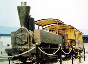
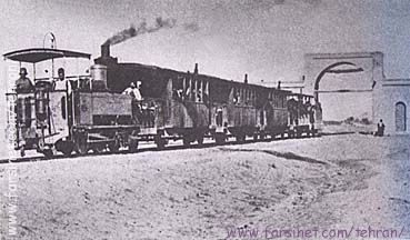
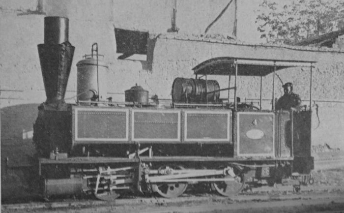
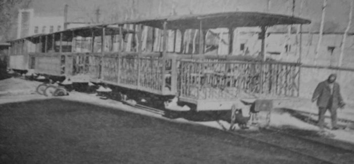
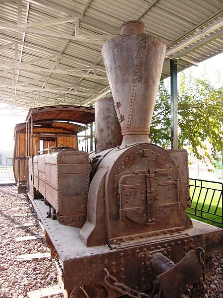
To finish this article here are three further pictures. The first is adjacent to this text and shows another of the locomotives used on the line and displayed on a plinth in Rey, (c) Alireza Javaheri, used under a Creative Commons Licence. [18]

The second and third pictures (below) show the station building which was the terminus of the old line in Rey. These two pictures are still-frame pictures from a German-produced Video which was made in the early 21st century. [19]

References

  1. M.H. Baker; The Iranian State Railways; in The Railway Magazine, January 1963.
  2. https://www.worldheritagesite.org/connection/Naser+ed-Din+Shah, accessed on 22nd March 2020.
  3. https://en.wikipedia.org/wiki/Diary_of_H.M._the_Shah_of_Persia_during_his_tour_through_Europe_in_A.D._1873, accessed on 22nd March 2020.
  4. Sidney J. A. Churchill, Memo, at the Shah’s Camp, 27 August 1888, enclosure in no. 13, Sir Henry Drummond Wolff to the Marquis of Salisbury, Gulahek [Golhak], 10 September 1888, FO 539/40 (Confidential 5755). Memo entitled: “Memorandum on Persian Railways”, p16 and quoted in reference 5. below.
  5. http://www.iranicaonline.org/articles/railroads-i, accessed on 22nd March 2020.
  6. “Acte”: “L’acte de constitution de la société du 17 mai 1887”, Recueil spécial des actes, extraits d’actes, procès-verbaux et documents relatifs aux Sociétés, Brussels, 1887, XV, pp. 865-69, quoted in reference 5. above.
  7. “Concession”, enclosure in no. 58, Sir Henry Drummond Wolff to the Marquis of Salisbury, Tehran, 8 October 1888, FO539/40 (Confidential 5755), quoted in reference 5. above.
  8. Otlet à Barbanson, 3 Juin 1887 (copie), Archives Générales du Royaume, Brussels, Fonds Otlet, liasse 4, quoted in reference 5. above.
  9. Albert Houtum-Schindler, “Persia,” Encyclopaedia Britannica, XXXI, 1902 (10th ed.), pp. 617-627.
  10. Baron E. Beyens, Commerce et industrie de la Perse, Brussels, 1898.
  11. Rapport”: “Société Anonyme des Chemins de Fer et Tramways en Perse, Assemblée générale du 4 juin 1888: Rapport,” Archives du Ministère des Affaires étrangères de BelgiqueBrusselsdossier 2889 II (1887-1908), quoted in reference 5. above.
  12. Ḥamida Amāni, “Farār az čarḵ-a-ye nābudi: Eḥyā-ye baqāyā-ye māšin dudi-e ḵ-aṭṭ-e āhan-e Tehrān Šāh ʿAbd-al-ʿAẓim,” Hamšahri, 25 Bahman 1383 Š./13 February 2005, available online, accessed on 22nd March 2020.
  13. https://www.internationalsteam.co.uk/trains/iran01.htm, accessed on 22nd March 2020.
  14. http://www.farsinet.com/tehran, acccessed on 22nd March 2020.
  15. https://en.wikipedia.org/wiki/History_of_rail_transport_in_Iran, accessed on 22nd March 2020.
  16. https://www.sinfin.net/railways/world/iran.html, accessed on 19th March 2020.
  17. http://www.museedelaporte.be/patrimoine/?p=1655&pdf=1655, accessed on 25th March 2020.
  18. https://commons.wikimedia.org/wiki/File:Old_steam_locomotive_in_Rey.jpg; https://web.archive.org/web/20161104221645/http://www.panoramio.com/user/1317158, accessed on 26th March 2020.
  19. DW Documentary; https://youtu.be/lqSoLVkYYu0, accessed on 25th March 2020.


Bideford, Westward Ho! and Appledore Railway – Part 3

This short series of posts was prompted by encountering a piece about the line on a facebook group. The group:

https://www.facebook.com/groups/rtvanished

The substantial link:

http://rfbwharailway.blogspot.com  [1]

In my first post I provided a few pictures of the station at Westward Ho! which had not appeared on the links above. The second post followed the line from Bideford to Westward Ho! This post covers the remainder of the line from Westward Ho! to Appledore.

The Bideford, Westward Ho! & Appledore Railway was incorporated on 21 May 1896, with its Head Office address at the Electrical Federation Offices in Kingsway, London WC2. Soon after the line passed to the British Electric Traction Company (BET). It was not until 24 April 1901 that the single track line was opened as far as Northam, although the first trial train ran with a few friends of the directors in January 1901. The first train, pulled by Grenville was played off by Herr Groop’s German Band which had been hired for the season and it reached speeds of 36 mph on its inaugural run. The remaining extension to Appledore finally opened in 1908, on 1st May, costing £10,000. The railway was built in three sections, with the first being from Bideford for just over the third of a kilometre; the second from the termination of the first, to Westward Ho!, a length 6 to 7 kilometres; and the third being from Westward Ho! to Appledore, a length of between 3 and 4 kilometres. [3]

Westward Ho! to Appledore

Westward Ho! Railway Station is shown to the right-hand side of the OS Map extract from the very early 20th century below. [5] The area has changed significantly over the years since then and is now heavily built-up. It is shown in the early 21st century in the satellite image an aerial photograph below the OS Map.Westward Ho! (Google Earth)The Westward Ho! Railway Station location in 2019.

Westward Ho! Railway Station, had two platforms of 320 ft long and just 1ft above rail level, platform lighting, a passing loop long enough to allow three coach trains to pass, a ticket office with waiting rooms and toilet, an 8-lever signal box and a 2-lever ground frame; a waiting room, refreshment room, bookstall, level crossing gates and a Concert Hall called the Station Hall. [2][6: p101][7: p20][8: p76] Provision was also made for access to Westward Ho! Gas Works – a siding controlled by a two-lever ground frame. [6: p106][8: p76]. A general view of the station site at Westward Ho! [3]Looking back into what was the Station site from the modern Golf Links Road (Google Streetview).The route of the old railway East of the Westward Ho! Railway Station (Google Maps)Looking East along the line of the old railway from Golf Links Road in the 21st Century (Google Streetview).

The line East of Westward Ho! was completed as far as Northam in 1901. The next two OS Map extracts show that length of line. The extracts come from the 25″ OS Series 1892-1914. [9] The line served Westward Ho! Gas Works, as we have seen in the notes about Westward Ho! Railway Station above, by means of a single siding. The ‘mainline’ ran to a run-round loop close to the road to Pimpley, north from Northam.From the Station Westward Ho! the line curved gently round to the Northeast before the Gas Works siding left the line on the right. A short distance further, the old route turned back towards the East and ran parallel to Golf Links Road. It ran on the South side of Golf Links Road all the way to Northam crossing Avon Lane and what was called Hanger’s Lane on the way. In the 21st century, Hanger’s Lane is now called Beech Road and what were open fields are now housing estates. [9]The route of the old line followed the Southern verge of Golf Links Road travelling East from Avon Lane (Google Maps).The site of the un-gated crossing at Avon Lane as it appears in the 21st century. The Gas Works was on Avon Lane at the far end of the open space. The southern pedestrian pavement of Golf Links Road and the kerbing between it and the carriageway is visible at the right-hand side of this picture. (Google Streetview).The approximate alignment of the old railway looking East along Golf Links Road in the 21st century (Google Streetview).Further East along Golf Links Road in the 21st century (Google Streetview).Further East again at the junction of Golf Links Road with Beech Road (former Hanger’s Lane). The buildings at the extreme left of the picture were in place when the railway was in use (Google Streetview).East of Beech Road the old alignment was just in open fields at the South side of Golf Links Road. The property on the North side of the road between what are now Millennium Way and Kingsley Park were known as Underborough and are now modern holiday lets (Google Maps).Wikipedia tells us that “Northam had one platform 180 feet (55 m) in length, with a shelter, on the down side of the line. It originally had a short run-around loop, a signal box and one semaphore signal, but with the completion of the extension to Appledore in 1908 it was reduced to a single line without sidings or signalling. [6: p110][8: p76] A goods yard was provided at one time.” [6: p61][10]

Beyond Northam, the line crossed Pimpley Road (now Sandymere Road) on the level by means of an un-gated crossing before reaching the Richmond Road request halt. [6: p110][10] The route of the line does not appear on OS Maps as, in this area, the different series were either complete before 1905 of not redrawn until after closure of the line. The route can be seen on a Bartholomew Map which is dated 1907, just before the opening of the extension to Appledore.The Bartholomew 1897-1907 series (not to scale) shows the approximate route of the formation of the railway. [11]Northam Station became a Halt in 1908 and the line continued on to Appledore (Google Maps).The approximate alignment of the old railway. Evidence on the ground is minimal as the line was very short-lived opening in 1908 and closing int he First World War (Google Maps). All of the 21st century roads and buildings visible on this satellite image were not present at the time the railway was in use.The route of the extension turned gradually to the North running just to the Northwest of Long Lane. The actual alignment is not clear. The alignment shown on the modern satellite images reflects the alignment drawn on the Bartholomew Map extract and the map at the head of this article.

There was a Halt at what s now called Burrows Lane and which used to lead out to the old Appledore Lifeboat Station and the old line then either crossed Long Lane at an un-gated crossing at a very shallow angle as suggested by the Bartholomew Map, or followed the Northwest verge of Long Lane as suggested by the map at the head of this article. I am unsure which of these routes applied but have chosen to show the route staying on the Northwest verge of Long Lane as this seems to fit best with the alignment further along the line. The historic Long Lane soon came to an end and the line continued along the shore line close to what is now the South West Coastal Path. The old line has been built over and is now used as a road providing access to Appledore. This work was completed in 1935 [12]. The start of this length can be seen on the immediately adjacent satellite image and continues on those which follow below. But first, a few images from Google Streetview which show the location of the Halt and  the probable route of the line to the Northwest of Burrows Lane.Looking back to the Southwest along the old railway alignment towards Northam Halt (Google Streetview).Looking Northwest along the probable route of the old line from the same point on Burrows Lane towards Appledore (Google Streetview).Looking back along Long Lane to the junction with Burrows Lane. The approximate route of the old line is shown (Google Streetview).Further to the Northeast along Long Lane at the point where the old lane finished. The line crossed between the building on the right and the building shown a little further in the distance. The road now follows the alignment of the line (Google Streetview).The alignment of the railway now provides the formation for Torridge Road which heads into Appledore (Google Maps).The old railway’s route into Appledore was through open fields but it now forms the spine of significant expansion of the town (Google Maps). There was a Halt at approximately the same location as the modern Lifeboat Station. The station in Appledore was a little to the West of the town/village centre.Locomotive Kingsley at Appledore Station with a single coach train. [4] Long after closure but in the early 1960s, this picture shows the station site and on the right, the ruined station building. [12]The site of Appledore Railway Station seen in the 21st century from the access to the Village/Town of Appledore.  The remains of the station building can be seen in the adjacent image (Google Streetview).

Wikipedia tells us that the station was the terminus of the 7½ mile line from Bideford. It served in this capacity from 1908 to 1917 when the whole line was closed for resources for the war effort in the Great War. [12][8: p29]. “Appledore had a 300-ft long, one-foot high platform, situated on the down side of the line. [8: p70] Brick built public toilets, a general and ladies waiting rooms and ticket office were provided, [6: p142] similar in appearance to those built at Westward Ho!. Two railway cottages were built at the site. [6: p113][8: p76] The station had gas lighting and was unique for the line in having a footbridge; this allowed access from Irsha Street to nearby allotments. [6: p113] A run-round loop was provided, together with a dead-end siding, engine shed, water tower, hydrant, and coal store. The signal cabin, situated on the platform, had ten levers and the station was controlled by up, down, and distant signals. [6: p142]” [12]An earlier image of what was the back wall of the station building showing the two old fireplaces. [13]

References

  1. http://rfbwharailway.blogspot.com, accessed on 5th June 2019.
  2. https://en.m.wikipedia.org/wiki/Westward_Ho!_railway_station, accessed on 5th June 2019.
  3. http://www.westwardhohistory.co.uk/the-railway, accessed on 5th June 2019.
  4. https://www.pinterest.co.uk/pin/172051648248692984/?lp=true, accessed on 6th June 2019.
  5. https://maps.nls.uk/geo/explore/#zoom=17&lat=51.0404&lon=-4.2419&layers=168&b=1, accessed on 30th November 2019.
  6. Stanley Jenkins; The Bideford, Westward Ho! and Appledore Railway; Oakwood Press, Oxford, 1993.
  7.  Julia & Jonathan Baxter; The Bideford, Westward Ho! and Appledore railway 1901-1917;  Chard, 1980.
  8. Rod Garner; The Bideford, Westward Ho! & Appledore Railway; Kestrel Railway Books, 2008.
  9. https://englishrail.wordpress.com/2009/09/14/bideford-westward-ho-appledore-rwy, accessed on 5th June 2019.
  10. https://en.wikipedia.org/wiki/Northam_railway_station_(Devon), accessed on 20th March 2020.
  11. https://maps.nls.uk/geo/explore/#zoom=14&lat=51.05353&lon=-4.20945&layers=156&b=1, accessed on 21st March 2020.
  12. https://en.wikipedia.org/wiki/Appledore_railway_station_(Devon), accessed on 21st March 2020.
  13. https://commons.wikimedia.org/wiki/File:BWH%26AR_Appledore_station_1969-70.jpg, accessed on 21st March 2020.

Resources for further investigation, [2]:

  1. Baxter, Julia & Jonathan (1980). The Bideford, Westward Ho! and Appledore railway 1901-1917. Pub. Chard. ISBN 0-9507330-1-6.
  2. Christie, Peter (1995). North Devon History. The Lazarus Press. ISBN 1-898546-08-8
  3. Garner, Rod (2008). The Bideford, Westward Ho! & Appledore Railway. Pub. Kestrel Railway Books. ISBN 978-1-905505-09-8.
  4. Griffith, Roger (1969). The Bideford, Westward Ho! and Appledore Railway. School project and personal communications. Bideford Museum.
  5. Jenkins, Stanley C. (1993). The Bideford, Westward Ho! and Appledore Railway. Pub. Oakwood Press. ISBN 0-85361-452-0.
  6. Kingsley, Charles (1923). Westward Ho! Pub. London.
  7. Stuckey, Douglas (1962). The Bideford, Westward Ho! and Appledore Railway 1901-1917. Pub. West Country Publications.
  8. Thomas, David St John (1973). A Regional History of the Railways of Britain, Vol.1: The Westcountry. Pub. David & Charles.


The Tanat Valley Light Railway and the Nantmawr Branch – Part 2

These two plans show the route of the Tanat Valley Light Railway and its place within the local railway network. [1]This plan shows the different parts of the Oswestry and Llangynog Railway. Its enabling Act in 1882 had 57 clauses and ran to 20 pages. The railway was described in three parts which were primarily associated with how it was to connect up with existing lines at its eastern end. Railway Number 1 would provide a connection with the Porth-y-Waen branch of the Cambrian Railway. This would give access to Oswestry. This section was to be one mile, one furlong, 5 chains and 10 links long. Railway Number 2 was the main part of the line up the Tanat Valley 13 miles and 2 furlongs in length. Railway Number 3 was a short fork (3 furlongs and 8 chains) at the eastern end of Railway No. 2 that linked the latter with the Potteries Shrewsbury and North Wales Railway branch that ran up to Nantmawr. Railway No. 2 could only connect with Railway No. 1 via a short section of the Nantmawr branch of the Potteries line. The sequence of opening had to be No. 1, then No. 2, then No. 3. [3][20]

Our journey along the Tanat Valley Light Railway (TVLR) commences the western end at Llangynog Railway Station.Llangynog Railway Station in 1930. [2]These two maps show Llangynog in 1840 and in 1902. If the second date is correct, although the railway has arrived at Llangynog, it will still be another two years or so before it is in use! [3] It is interesting to note that the railway station (4) is not the only addition to the village between the two maps being drawn. Some new cottages have been built (1), a school has been set up (2), and a Chapel has been established (3).The Victorian period saw a great rise in the number of chapels as communities set up new places of worship where they could worship in their own way and in their own language. This often meant an over-provision within a local community with chapel and church seats well in excess of the total population of a village or town.

The railway station was situated on the north side of the river. The centre of the small village of Llangynog was on the South side of the river.This picture shows Llangynog Station after closure. It is held by the People’s Collection of Wales. [4] The location is now a caravan park, as shown on the Google Earth image below. This OS Map is an extract from the 1:25,000 series from the mid-20th century. [5]

Wilfred J. Wren provides hand drawn maps in his book about the Tanat Valley which was published in 1968. The drawings were completed in 1966. Llangynog is shown immediately below. [8: p106] The station itself took up a significant area of land on the North side of the Afon Eiarth. At the West end of the site a level crossing allowed access across the village road to two exchange sidings. A tramroad ran from the Granite Quarries further West to the exchange sidings. At a later date the Granite Wharf was moved to very close to the station Goods Shed on the South side of the Slate Wharf.The Tramroad served Maker’s Granite Quarries. In the hand-drawing below, the Tramroad runs along the bottom side of the map, from the wharves close to the village along the Northeast side of the Afon Eiarth until close to the quarry access where a bridge took it over the river opposite Pencraig.  In addition, an incline ran from the tramway up to Ochr-y-Craig Granite Quarry high on the hill on the North side of the river valley. [8:127][9].Maker’s Granite Quarry was opened in 1904 by Maker, who came from the North of England. Stone was crushed on the quarry floor and then lifted to road level up an incline. Initially the minor road was used to transport the granite to Llangynog. It was decided, within a few years, to use the Tanat Valley Light Railway (TVLR) for transporting chippings and a transfer wharf was built at the site of the Ochr-y-craig lead mine and a tramway linked the quarry and the transfer wharf. Wren says: ‘The building of the tramway involved a causeway near the quarry, a timber bridge across the Eiarth, the filling-in of the northern channel of the Eiarth near the corn mill, and high-level banks at the exchange sidings to bring the tramway trollies above the level of the railway trucks for ease of transfer. The tramway worked by gravity, the empties being pushed back by hand.’ [8: p159]

The quarries were worked until 1933 and the leases were then acquired by Amalgamated Roadstone who still held them in the late 1960s.The site of Llangynog Railway Station in 2018. [6]The old railway route runs on the north side of the Afon Tanat as it heads East from Llangynog. At times it runs very close to the river as is evident on the right side of the Google Earth Image above and on the OS Map extract below, near to Glanhafon-fawr [5]The view Northwest from Bont-Fawr showing the route of the old railway on the North side of the lane which followed the bank of the River Tanat. The river is off the picture to the left. The station is off to the right (Google Streetview).Slightly further East in the 21st century, looking back West towards Bont-Fawr which is close to the chevron sign in the centre-right of the picture. The line crossed the road here and entered the station site which was off to the left of the picture (Google Streetview).From the same point looking Northeast. The red line shows the approximate line of the old railway through Pen-y-Bont-Fawr station (Google Streetview).

The following links are provided with permission from Francis Firth [7] using their website’s embedding service. All are photos of Penybontfawr Village c.1955 and all seem to show different portions of the main street at that time:

https://www.francisfrith.com/penybontfawr/penybontfawr-the-village-c1955_p274015

https://www.francisfrith.com/penybontfawr/penybontfawr-the-village-c1955_p274014

https://www.francisfrith.com/penybontfawr/penybontfawr-the-village-c1960_p274029

Sadly, none of these images show the railway station, but they give an excellent impression of the village in the 1950s. The railway station was, as can be seen on the OS extract above, sited a few hundred metres north of the village on the North bank of the Afon Tanat. It was a simple affair with a timber-faced platform and a small waiting shelter for passengers, both on the South side of the tracks. The platform was backed by a fence of vertical iron railings and the boundaries of the site were marked by timber fencing as one of the few pictures of the station shows. That picture is covered by copyright and is regularly for sale as a print on eBay. It seems to show the local goods waiting in the loop while two prospective passengers look West along the line in the hope that the passenger service from Llangynog will soon arrive at the station. [10]Pen-y-bont-fawr Railway Station. [8: p106] The goods facilities and yard were on the North side of the Station.

Penybontfawr Community Council describes to village in the 21st century: “Penybontfawr  is situated at the confluence of the river Tanat and the river Barrog in the upper Tanat valley.The village is surrounded by steep hills, forests and waterfalls and is an excellent start from which to explore the Berwyn mountains. The village has a good range of community services and facilities. Siop Eirianfa and post office, garage, Railway Inn, primary school. community centre, church and chapel are all to be found within easy walking distance of the village centre. Tanat Valley buses provide a service to Llanrhaedr ym mochnant and the local market town of Oswestry. The area has a strong tradition of Welsh culture and many people speak Welsh either as a first or second language – great pride being taken in the traditional and contemporary music making of the community! Each year the combined village horticultural and sheep dog trials on August bank holiday weekend draw visitors from both far and near.” [11] No mention is made on the webpage, as yet, of the importance of the old railway in the development of the valley or the village.

From Pen-y-bont-fawr the old railway continued East along the North bank of the River Tanat with the roads serving the valley running on the South side of the river. The next halt is shown at the right-hand end of the OS Map extract below – Pedair-ffordd Halt.The approximate line of the old railway to the East of Pen-y-bont-fawr (Google Earth).The route of the old line continues to the North side of Castellmoch-fawr Farm (at the right side of this image) (Google Earth).The old line crossed the modern B4396 just before reaching Pedair-ffordd Halt (Google Earth).The view North-northeast from the bridge over the River Tanat along the B4396. The old railway crossed the road just before the bend visible in the distance (Google Streetview).The approximate line of the old railway approaching the B4396 from the West (Google Streetview).Looking East along the route of the old railway line. The B4396 is in the foreground of this image, the location of the Pedair-ffordd Halt halt was just beyond the modern garage (Google Streetview).The remains of Pedairfford Halt in November 1979 (c) Alan Young. [21]

Immediately North of the old level crossing the B4396 turns right to run on an East-West alignment alongside the route of the old railway. Both the modern road and the old railway route follow the contours on the Northern edge of the River Tanat flood plain through Llanrhaiadr Mochnant Station. The station was sited around 3/4 mile to the Southeast of the village it served (Llanrhaiadr-ym-Mochnant).The site of Llanrhaiadr Mochnant Station viewed from the East in 2019. The old line crossed the B4580 on the level at the East end of the station site (Google Streetview). The station had two platforms and a passing loop as well as sidings to a goods yard and cattle dock. [12]Llanrhaiadr-Mochnant-Station taken from a Stephenson Locomotive Society enthusiasts special train in 1958 (above), looking West through the station site. [12] The adjacent image is of the same train in the station, this time taken from the West. The Station was still in use at this time for freight. [13] Llanrhaiadr-Mochnant Station again. This picture show s it in 1947 with a trail heading for Llangynog in the down platform. [8: p80a – Plate 19] The full layout of the station is visible in this image. The level-crossing at the East end of the station can just about be seen. The two platforms are in the centre of the picture. The two buildings on the up platform are, nearest to the camera, the gents and then the main passenger building which included the ladies. Opposite, on the down platform is a small shelter. The cattle dock is not quite visible on the front left of the picture but the yard siding which had a goods shed with an awning is well-used. A hand drawn plan if the station site is available in Wren’s book. [8: p104]

Writing in 1968 Wilfred Wren commented that, “the station yard at Llanrhaiadr-Mochnant [was] still used partly for coal storage; at the western end there [was] a hugh pile of wooden sleepers.” [8: p105]

Beyond Llanrhaiadr-Mochnant the old line remained on the South side of the B4396. Across the width of the first three fields its route has been obliterated by ploughing and can only be made out in the form of a slight shadow on the satellite images that are available. The fourth field has a slight rise in it and the old line needed a shallow cutting. The Google Streetview image below shows that the route of the old line can still be identified by that cutting.The B4396 looking East. The shallow cutting made for the Tanat Valley Light Railway can be made out just to the right of centre in the image (Google Streetview). The line curved round more to the Southeast through the cutting before realigning once more to the East-Southeast.

A few hundred yards to the East both the road and old railway crossed the Afon Iwrch. The crossing point is just visible on the right of the satellite image above and in the top left of the first image below. The line ran Southeast towards Pentrefelin Halt.Pentrefelin Halt served a small village. Wikipedia says that “The platform was located to the east of a level crossing on a minor road to Glantanat Isaf. The platform had a corrugated iron shelter, lamps and a nameboard. There was a goods loop on the north side of the line. The platform is still extant on farmland.” [14] Wren says that, “the large station area at Pentrefelin was used for the unloading and storage of pipes for the second line in the Vyrnwy aqueduct.” [8: p105]

After Pentrefelin Halt, the line drifted closer to the Rivar Tanat crossing the Afon Lleiriog. Eventually, the old line crossed the River Tanat and then followed the South bank of the meandering river. The bridge can be picked out at the bottom right of the last OS Map extract above and its location can be seen on the right of the Google Earth satellite image below.Wren commented that in 1968 the track-bed East of Llanrhaiadr-Mochnant through to Blodwell Junction was in near-perfect condition, broken only by the gaps of the salvaged river bridges near Pentrefelin and Llanyblodwell. Along this length, bridges over the Rhaeadr and Iwrch also only had abutments and foundations left in 1968. [8: p105]Once the River Tanat had been crossed, trains continued Eastward, protected in places by significant earthworks from erosion by the river, to Llangedwyn Halt which can be seen on the OS Map extract below. [5] The Google Streetview image which follows shows a view taken from the North of what was once a level-crossing over the lane to the West of the Halt. The low embankment on which the formation of the old railway was laid can still be picked out carrying the field access to the right of the picture. The Halt was located off to the left of the picture.The halt at Llangedwyn was slightly more substantial that its designation as a halt suggests. At one time, probably until the mid-1920s there was a passing loop here and a long siding followed the North boundary of the station site. The passenger platform was at the South side of the site and was bout 17 ft longh with a small shelter provided to protect passengers from the waether. On the North side of the loop there was a cattle dock. The station was about 400 yards from the village. [8: p104] As can be seen in the Google Earth satellite image above, a number of farm/industrial buildings associated with Llangedwyn Home Farm  have covered the site of the old halt. [15]The next station on the old line was at Llansilin Road. It was reached on a slightly more meandering railway just to the South of the course of the River Tanat. The railway route and the location of Llansilin Road Station are shown on the satellite images from Google Earth above. Wren comments that at “Llansilin Road, a station master with an artistic bent erected three square-tiered ornaments, made of concrete and stuck in the manner of Antonio Gaudi with fragments of chins plates.” [8: p105] These were erected at the back of the passenger platform which was on the South side of the running line. The platform, as at Llangedwyn was about 170ft long with a small corrugated iron shelter at the Eastern end. A cattle dock was placed alonside the passing loop which was on the North side of the main-running line and a further single siding was provided which had a short loading wharf and a coal storage arch. [8: p102][16]

The station had the “Road” suffix due to being 3 miles south from Llansilin and 4 miles by road. The station was located close to the hamlet of Pen-y-bont Llanerch Emrys, two miles east of Llangedwyn village, where the road from Llansilin joins the river valley. The location on the OS Map extracts below [5] was close to the 343ft height marker on the second image. [16]Looking West from the old level-crossing into the site of Llansilin Road Station. The old passenger platform appears still to be present on the left of the picture (Google Streetview).

A short distance after Llansilin Road, the old trackbed turns North following the River Tanat.It then, once again swings round through East towards Southeast as shown on the two OS Map extracts below.The satellite images from Google Earth are less well defined over the next part of the old route. So the high-level images are provided by Bing and are aerial, rather than satellite, images. The old railway followed approximately the 300ft contour with the valley side rising relatively steeply just South of the formation of the railway. The halt given the name Glanyrafon was at the point on the line marked by the word “Garth-fach” on the agacent OS Map extract. [5] Its namesake was on the North side of the river at that point. The halt had a 75ft platform and small shelter.From Glanyrafon Halt, the route continued round the outside of the loop in the River Tanat which circles around Llanyblodwel and crossed the road which ran South through that village and across the River Tanat on the level.

En-route, the old railway passed through Llanyblodwell Halt – a 170ft platform with a shelter sat on the down side of the running line. A gents was provided at the West end of the platform.Llanyblodwell Halt was just to the south of the 278ft height point on the OS Map extract above. [5] Looking West into the site of Llanyblodwell Halt from the road crossing at its Eastern boundary (Google Streetview) Incidentally the spelling of the name of the Halt is correct even though the village it served was named Llanyblodwel.Looking East along the old railway line from the road-crossing at Llanyblodwell Halt (Google Streetview).

The old line crossed the River Tanat again before entering Blodwell Junction Station.The Tanat Valley Light Railway (TVLR) met the Llanymynech Loop line just the the Southwest of the Station at what was known as Blodwell West Junction. [8: p105] The OS Map extract above [5] shows the stub-end of that Loop line which remained in existence until the closure of the TVLR. The Junction Station sat between Blodwell West Junction and the road over-bridge which carried the A495 over the line and which is evident on the same map-extract. [5] The goods facilities were sited to the East of the road over-bridge. [17]Blodwell Junction Station is marked on this aerial view together with the alignment of the old TVLR and the Llanymynech Loop (Bing Aerial Maps).

I am indebted to the Disused Stations website for some of the notes below. [17]

Blodwell Junction was opened in 1870 and at the time called Llanyblodwel. It was opened by the Potteries, Shrewsbury & North Wales Railway (PS&NWR) and was at that time situated on the PS&NWR Nantmawr Branch, a 3¾-mile line that had opened in 1866. The Nantmawr branch provided a link between the Cambrian Railways (CR) line at Llanymynech and quarries at Nantmawr. The PS&NWR was not a financial success and it went into receivership in December 1866. Trains ceased to run just before Christmas that year. [17]

This was only a temporary situation. The receiver began running services again in December 1868 and in 1870 introduced a passenger service onto the Nantmawr Branch for the first time. The terminus for passenger services was at Llanyblodwel. [17]A hand-drawn map of the Nantmawr Branch as it was in 1875, produced by Alan Young in 2016 and used with his permission, (c) A.E. Young. [22]

The platform which was constructed to facilitate passenger services ready for the 1870 opening remained in place on the North side of the run-round loop until final closure occurred. It was “constructed from brick, backfilled with earth and topped with cinders. A single-storey timber building located at the eastern end of the platform provided booking and waiting facilities.” [17] A small ‘gents’ was provided to the west of the passenger building.

The receiver could not make the PS&NWR line pay and eventually withdrew train services in 1880. Llanyblodwel station was closed and fell into a state of dereliction. [17]A view of the station looking north-east in 1903 during the period when it was closed. The station had closed as Llanyblodwel on 22 June 1880 but within a few months of this view being taken it would reopen as Blodwell Junction, (c) E E Fox-Davies – used with permission from the ‘Disused Stations’ website. [17]

Construction of the TVLR started in 1901. “The TVLR route made use of two existing lines. At Llanyblodwel it used 19 chains of the Nantmawr branch through the site of the station. Further east it used 78 chains of the Cambrian Railways (CR) Porthywaen Branch which connected to the CR main line at Llanclys.” [17] An intermediate section of line of 1 mile 21 chains in length was built from Llanyblodwel station to the Porthywaen Branch.Blodwell Junction station and the Nantmawr branch shown on a Railway Clearing House map from 1915. The Nantmawr branch is shown coloured green. Coloured in orange is the Tanat Valley Light Railway the opening of which in 1904 created the Junctions at Blodwell. [17]

The station was renamed Blodwell Junction and a new signal box was constructed at the Southwest end of the station platform to control train movements.Blodwell Junction Station. This picture of the passenger facilities and Signal Box were taken from the A495 road overbridge. The view looks West-Southwest towards Llangynog . In the distance on the left is the route of Llanymynech Loop line. The TVLR eads off the the right. The line from Oswestry (also east from Gobowen) to here was mothballed by Network Rail in 1988 and in 2008 was acquired by the Cambrian Railways Society, (c) Ben Brookbank. [18]Blodwell Junction station looking north-east on 4 November 1979, (c) Alan Young, used with permission obtained through the ‘Disused Stations’ website. This view is taken from a very similar position to the monochrome image from 1903 above. [17]The end of the line! This picture looks Southwest through the road-overbridge carrying the A495 in the late 20th century. Beyond the bridge is the site of what was Blodwell Junction Station platform. The station’s goods facilities were on this side of the bridge. [19]

I was able to take a few pictures in August 2019 at this location. The first shows the access road to the goods yard from the North with the A495 on the right of the photo. The bridge carrying the road over the old line features next. The buffers remain as do the two supporting piers to the bridge. The third view below is taken from the road bridge looking down on the tracks to the Northeast of the bridge. The fourth image is an attempt to look forward along the old track-bed in a Northeasterly direction.An aerial view of the route of the TVLR to the East of Blodwell Junction. The black and white dotted line shows the track purchased by the Cambrian Railway Society which remains in place in the early 21st Century. The Natmawr Branch leads to the location of the Nantmawr Quarry and the length of line in the possession of the Tanat Valley Light Railway Preservation Society, (Bing Aerial Maps).

The remaining length of both the Nantmawr Branch and the TVLR are shown on the OS Map extract below. [5] The TVLR ran through to Porthywaen where it met the Cambrian Railways Branch which served the quarries at Porthywaen. The surviving length of then TVLR is shown in theses two aerial images marked by a black and white dotted line. The quarries are still in use and the old overbridge which took a country lane over the CR Branch is still in place and continues to include the old tramway overbridge for the Crickheath Tramway. The bridge is dated 1861. [8: p100] It appears in the top right of the OS Map extract below.

The old CR Branch to the quarries ran to the North side of Coopers Lane in the first of the aerial images. The two lines met immediately after the Halt location shown below.Porthywaen Halt was just to the Northeast of a road-crossing on the A495 between Llanyblodwell and Llynclys. This picture shows the halt in use in 1979 and is taken from the Northeast end of the site close to the junction with the CR, (c) Alan Young, used with permission. [21]A larger scale extract from the OS Map shows the location of Porthywaen Halt and the junction with the Cambrian Railway Branch close to the road entrance to the quarries to the North of the line. [5]The TVLR crosses a side road (Porthywaen School Road) close to the A495. This view is taken looking Southwest (August 2019).Turning through 180 degrees at the same point as above (August 2019).

Google Streetview has older images at this location which were taken in 2010. The line had clearly, at that time, been cleared of vegetation which has since taken hold. The enxt two images show the condition of the line in 2010.A view looking Southwest in March 2010 (Google Streetview).The same date looking to the Northeast Google Streetview).Looking Southwest towards Llanyblodwel in 2010 from the level-crossing at the A495 (Google Streetview).Turning through 180 degrees, this is the view Northeast along the line. The old halt was on the right of the tracks ahead, close to the bungalow which is visible in the picture (Google Streetview).A view from the end of the bridge parapet down onto the line (August 2019).This is the closest that I could get to the bridge over the line to the Northeast of the old Porthywaen Halt. The cast/wrought iron span is dated 1861. The tramway span can just be made out through the undergrowth. The picture is taken from the colliery access road (August 2019). The view from the same bridge looking Southwest down onto the railway line in August 2019. The old halt was to the left of the track about 100 yards ahead.

This bridge is the limit of our journey along the Tanat Valley Light Railway as we are now over what were Cambrian rails. We need to retrace our steps to Blodwell Juntion to look at the Nantmawr Branch.

The Nantmawr Branch

We have already established that the Nantmawr Branch was in place prior to the construction of the TVLR. Tracks were first laid long before the TVLR was considered. The directors of the Potteries, Shrewsbury & North Wales Railway (PS&NWR) hoped that the link to the quarry at Nantmawr would provide a much needed boost to income for their line to Shrewsbury. The gains in traffic were not sufficient to save the PS&NWR and ultimately the receivers were also unable to make the branch nor the longer line pay, and closure occurred in 1880.

The Branch ran from Llanymynech Junction to the Natmawr Quarry and I have repeated Andy Young’s hand-drawn map which shows the route to best effect. The darker line on the map is the length of the passenger service on the branch when it was operating. This map shows the crossing points for river, rail and canal but, so as not not over-complicate the map, does not show crossing points for the roads in the area. 
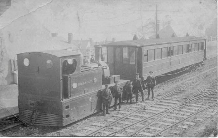
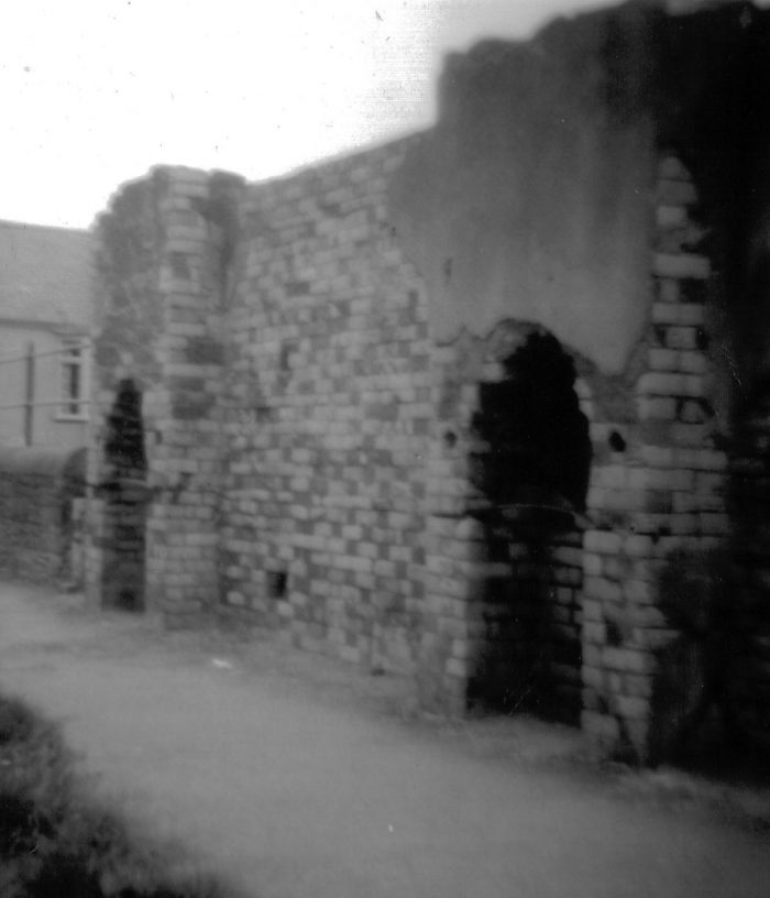
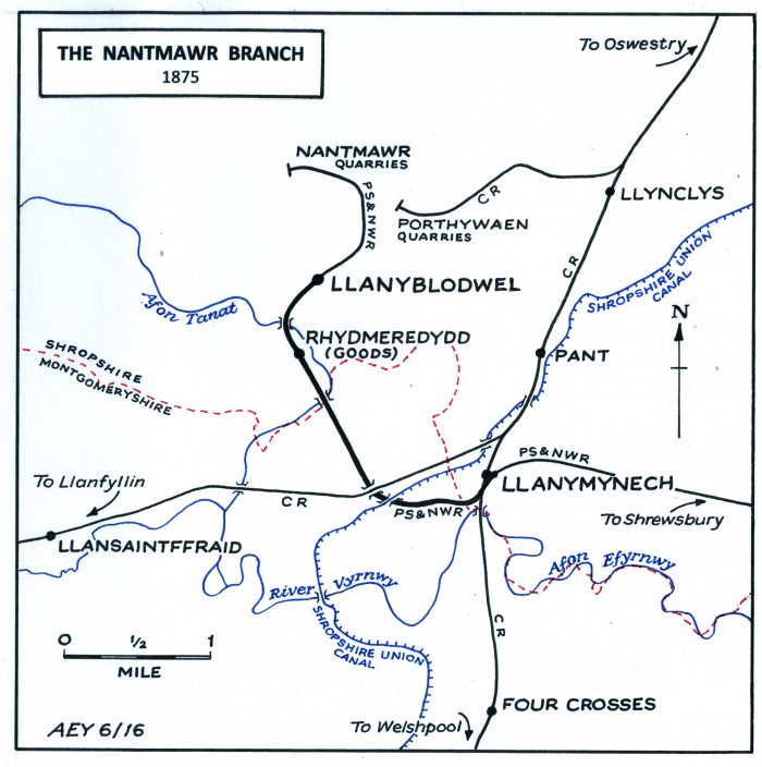
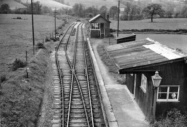
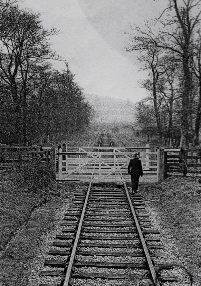
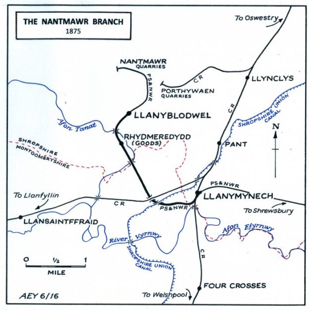
Nantmawr Branch as it was in 1875, (c) A.E. Young. [22]

Wilfred Wren says of the line: “Possibly no such short length of line has had a more fascinating or more chequered history.” [8: p33]

1866 saw the line open from Llanymynech to Nantmawr. Wren continues, “the line crossed the Oswestry-Newton tracks on the level, bore west … under the road and the canal by an expensive double bridge, ran under the Llanfyllin brach at Wren, and crossed the River Tanat twice on timber viaducts to avoid a spur of Llanymynech Hill at Carreghofa.” [8: p34]

The line then turned relatively sharply from a northwesterly direction to the northeast and entered what was then called Llanyblodwell Station. The railway then “turned north up the little steep-sided valley to the Nantmawr quarries; on this section one road crossed it on an over ridge and another by a level-crossing.” [8: p34]

There was at one time an intention by the PS&NWR to push a double-track mainline from Shrewsbury up the Tanat Valley. It is interesting in that context to note that when Wren was writing in the 1960s the Nantmawr branch was crossed by a road bridge between the two Tanat viaducts which allowed for a double-track main line along the Nantmawr branch but Turing away to the West before Llanyblodwell Station.

We noted earlier that the branch was closed in 1880. This is true, but Wren records a number of goods movements over the deteriorating tracks which provided a steady but small revenue. [8: p36]

During the building of the Tanat Valley line, the Cambrian upgraded the two mm internal branches, Nantmawr and Porthywaen, to make them suitable for passenger services. “The original timber viaducts which carried the Nantmawr branch over the Tanat river were rebuilt with concrete piers and abutments, plank flooring and steel railings; the track had previously been laid on longitudinal timbers using tie-bars, the gap between the rails being open to the river below. Both branches were reballasted and not in fact laid with new track, since an observer in 1904 noticed that the rails and chairs bore dates ‘in the sixties’.” [8: p47]

Use of the line between Wern and what was letter called Blodwell Junction was always sporadic. The hoped for link direct from the line to the Tanat Valley line in a westerly direction was never completed. The line “lingered on as part of the Nantmawr mineral branch after the Cambrian had been absorbed into the Great Western at the grouping. In 1925, all traffic on it ceased, the rails were lifted by 1938 and the cuttings filled in, and the track-bed became the tangled wilderness it is today.” [8: p49]Looking South from the A495 towards Blodwell Junction in 2010 (Google Streetview).Looking North along the branch to Nantmawr from the A495 in 2010 (Google Streetview).

In the 21st century, the Nantmawr branch climbs from Llanddu to Nantmawr. It passes under the A495 road bridge and then across Whitegates crossing before curving gently to the left, crossing a small stream and entering the quarry site. A run round loop is provided at each end of the line. The line is operated by a preservation society called the “Tanat Valley Light Railway.” [24]Whitegates Crossing while still is use as a branch-line, looking South towards the A495. [27]Whitegates Crossing in 2010 (Google Streetview).The view down the line from the Quarry in 2019, (c) Chris Allen used under a Creative Commons Licence. [28]Whitegates Crossing in 2019, (c) Chris Allen used under a Creative Commons Licence. The crossing was restored but has since deteriorated. [29]

The pictures above must have been taken at around the time my wife and I visited the line. Sadly we arrived on a day when the preservation site was not open. These are the pictures that I took of the crossing. …….This final picture shows the entrance to the preservation site in August 2019.

There is an excellent short illustrated history of the Nantmawr Quarry and Lime Kilns on the Oswestry Borderland Heritage website:  http://www.oswestry-borderland-heritage.co.uk/?page=133 [26] and http://www.oswestry-borderland-heritage.co.uk/?page=137  [27]

TripAdvisor has a number of photographs of the site. Here are three to whet your appetite. …. [25]This last image shows the dominant limekiln structure on the site. [25]

References

  1. https://en.wikipedia.org/wiki/Tanat_Valley_Light_Railway, accessed on 7th September 2019.
  2. https://en.m.wikipedia.org/wiki/Llangynog_railway_station, accessed on 17th September 2019.
  3. http://history.powys.org.uk/school1/llanfyllin/gyn1902.shtml, accessed on 19th September 2019.
  4. https://www.peoplescollection.wales/items/873156, accessed on 28th December 2019. This item is made available under Creative Archive Licence espoused by the People’s Collection Wales, https://www.peoplescollection.wales/creative-archive-licence, details accessed on 11th January 2020.
  5. https://maps.nls.uk/geo/explore/#zoom=16&lat=52.8251&lon=-3.4038&layers=10&b=1, accessed on 11th January 2020.
  6. https://en.wikipedia.org/wiki/Llangynog_railway_station, accessed on 14th January 2020.
  7. https://www.francisfrith.com/penybontfawr/penybontfawr-the-village-c1955_p274015, accessed on 14th January 2020.
  8. Wilfred J. Wren; The Tanat Valley: It’s Railways and Industrial Archeology; David and Charles, Newton Abbot, 1968.
  9. http://www.oswestry-borderland-heritage.co.uk/?page=185, accessed on 14th January 2020.
  10. https://www.ebay.co.uk/itm/Penybontfawr-Railway-Station-Photo-Llangynog-Pedair-Ffordd-Tanat-Valley-1-/252241054294, accessed on 15th January 2020.
  11. http://www.penybontfawrvillage.org.uk/index.html, accessed on 2nd March 2020.
  12. https://en.wikipedia.org/wiki/Llanrhaiadr_Mochnant_railway_station, accessed on 9th March 2020.
  13. http://www.oswestrygenealogy.org.uk/photos/osw-np-o-5-16-73-llanrhaeadr-junction-1958, accessed on 9th March 2020.
  14. https://en.wikipedia.org/wiki/Pentrefelin_railway_station, accessed on 9th March 2020.
  15. https://en.wikipedia.org/wiki/Llangedwyn_Halt_railway_station, accessed on 11th March 2020.
  16. https://en.wikipedia.org/wiki/Llansilin_Road_railway_station, accessed on 11th March 2020.
  17. http://disused-stations.org.uk/b/blodwell_junction/index.shtml, accessed on 19th September 2019.
  18. https://www.geograph.org.uk/photo/1836071, licensed for reuse under a Creative Commons Licence, accessed on 12th March 2020.
  19. https://mapio.net/pic/p-36639165, accessed on 12th March 2020.
  20. https://oldrailwaystuff.com/oswestry-and-llangynog-railway-acts, accessed on 19th September 2019.
  21. A.E. Young, used with permission, sent by email on 12th March 2020.
  22. A.E. Young, June 2016, used with permission, sent by email on 12th March 2020.
  23. http://www.cambrianrailwayssociety.co.uk/thebranchproject/routedescription.html, accessed on 13th March 2020.
  24. http://www.tanatvalleyrailway.co.uk, accessed on 17th March 2020.
  25. https://www.tripadvisor.co.uk/Attraction_Review-g504106-d8617050-Reviews-Tanat_Valley_Light_Railway-Oswestry_Shropshire_England.html, accessed on 17th March 2020.
  26. http://www.oswestry-borderland-heritage.co.uk/?page=133, accessed on 17th March 2020.
  27. http://www.oswestry-borderland-heritage.co.uk/?page=137, accessed on 17th March 2020.
  28. https://www.geograph.org.uk/photo/6235917, accessed on 17th March 2020.
  29. https://www.geograph.org.uk/photo/6227779, accessed on 17th March 2020.

Les Chemins de Fer de Provence – an update on maintenance work!

News from the South of France. This post is almost entirely a translation of a recent article in French in TPBM (Travaux Publics & Batiments du Midi) Press. [1]

Back in January 2019, major work on the Chemins de fer de Provence line was started only to be marred one month later by the death of a worker following the collapse of part of the railway tunnel at Moriez. [2]  Work on the tunnel was inevitably delayed as a result of the accident and the overall work programme on the line has had to be adjusted.

The authorities are investing significant sums in necessary maintenance work which is now programmed to run until 2022. Expenditure will exceed €59.5 million.

Closure of the tunnel at Moriez has meant that all traffic between Alpes-Maritimes and Alpes-de-Haute-Provence along the line has been halted. This has meant that Le Train des Pignes has also been prevented from providing a tourist service on the route.

There has been a significant worry for many in the valleys served by the railway and among those with a commitment to the Train des Pignes that the necessary repairs to the tunnel after its collapse would prove prohibitive. The good news is that the authorities have not found further major structural problems with the tunnel, nor along the length of the line. They have recently confirmed that work priorities remain as originally intended.

A spokesperson said that ” Inspections did not reveal any unfavourable evolution of pathologies requiring a change in priorities. Structures are monitored regularly: monthly visits, annual inspections, detailed inspections every five to seven years.”

Work  on the line has continued since inspections were undertaken. ….. Progress has be good!

A little over a year after the tragedy at Moriez, the renovation of the track in 14 stations and on different sections over 12 km has been carried out, the platforms of 16 stopping points have been renovated and made accessible. The old depot at Saint-André-les-Alpes has been restored and the tunnels at La Mescla, La Colle-Saint-Michel and Chabrières have been reinforced. Four level crossings have also been automated.

Going forward, the four areas affected by the bad weather in November will be repaired during this Spring. The first of these will start at the end of February. The dikes and other engineering structures will be consolidated. 

Repairs to the Moriez tunnel are on-going and are scheduled for completion in the summer.

The stations at Puget-Théniers, Entrevaux, Annot, Thorame and Saint-André-les-Alpes will be renovated and their forecourts redeveloped. Four new stops will also be made accessible.

Although the Chemin de fer de Provence line has been heavily impacted by the weather in recent months, the Region “is committed to carrying out the work that will enable the line to be reopened” without announcing a specific date.

On average, Le Train des Pignes used to carry 400,000 passengers a year between Nice and Digne-les-Bains. For the time being, shuttle buses run between Digne-les-Bains and Plan de Var until the railway line is fully restored.

References

1. https://www.tpbm-presse.com/595-millions-d-euros-pour-faire-circuler-a-nouveau-le-train-des-pignes-3451.html?fbclid=IwAR0pdkw-iYw9Sw8tjeeczD5LuYrXw3V5CPfFYVfikUS-hQ-BdRgjY0fiNeA

2. http://www.hauteprovenceinfo.com/article-24385-effondrement-d-un-tunnel-ferroviaire-a-moriez-retour-sur-cet-accident-qui-a-coute-la-vie-a-un-ouvrier.html