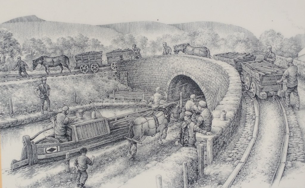
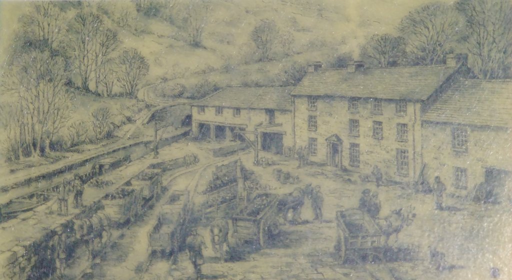
Bailey’s Tramroad and the Monmouthshire & Brecon Canal by Michael Blackmore. This sketch is included on the information sign at Govilon Railway Station which is now disused and lives on in an extended and altered form as a private dwelling. The drawing shows the Tramroad bridge over the canal which led to the Wharf. Notice the plateway itself which is formed of L-shaped cast iron plates resting on stone blocks. (Extracted from my photograph of the information board taken on 25th April 2022)
It was actually quite a short walk, I only had just over an hour spare in a trip to Abergavenny. I took the opportunity to have a look at the Wharf at Govilon and the first few hundred yards of Bailey’s Tramroad.
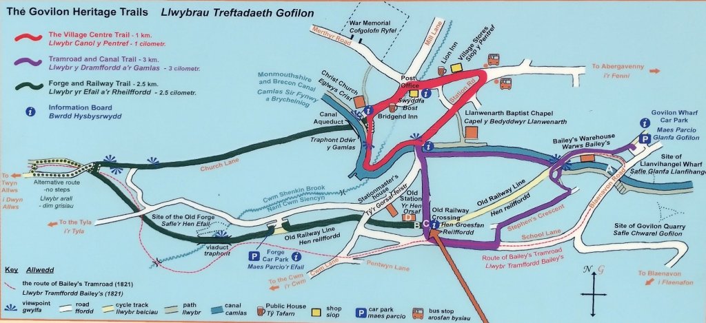
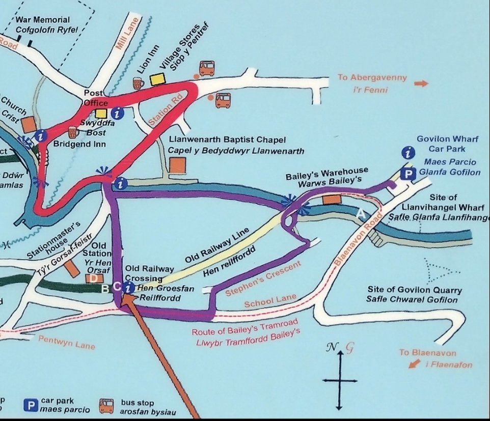
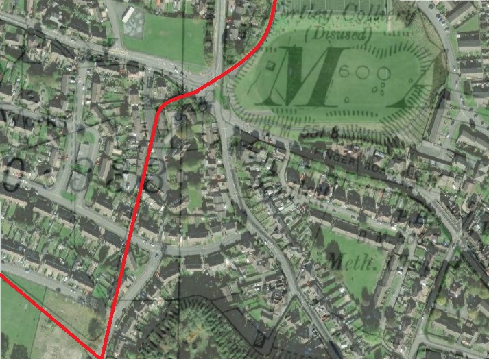
The location plan on the information board at Govilon Railway Station. Note the red dotted line which shows the route of Bailey’s Tramroad; the location of Bailey’s Wharf and Govilon Wharf at the right side of the image; the route of the canal shown in blue; and the route of the railway in cream on the right half of the map and in green as part of one of the village trails.A closer view of the map. The bridge which carried Bailey’s Tramroadover the Canal is marked ‘A’; the Railway Station site is marked ‘B’, ‘C’ and ‘D’. The route followed left this location in an Northeastward direction (cream), crossed the railway bridge over thecanal and followed the line of the railway on the North side of the sailing club wharf. I then crossed the tramway bridge and wandered a short distancealong the canal towpath to view the wharf building to the southeast of the road. To complete the walk I followed School Lane back to the Railway Station.
Bailey’s Tramroad from the Nantyglo Ironworks to the Canal at Govilon opened in 1821. Michael Blackmore’s illustration depicts the tramroad as it crosses the canal to enter Govilon Wharf. Here iron, coal and limestone were taken from the horse-drawn trams onto narrowboats bound for Newport and the wider world.
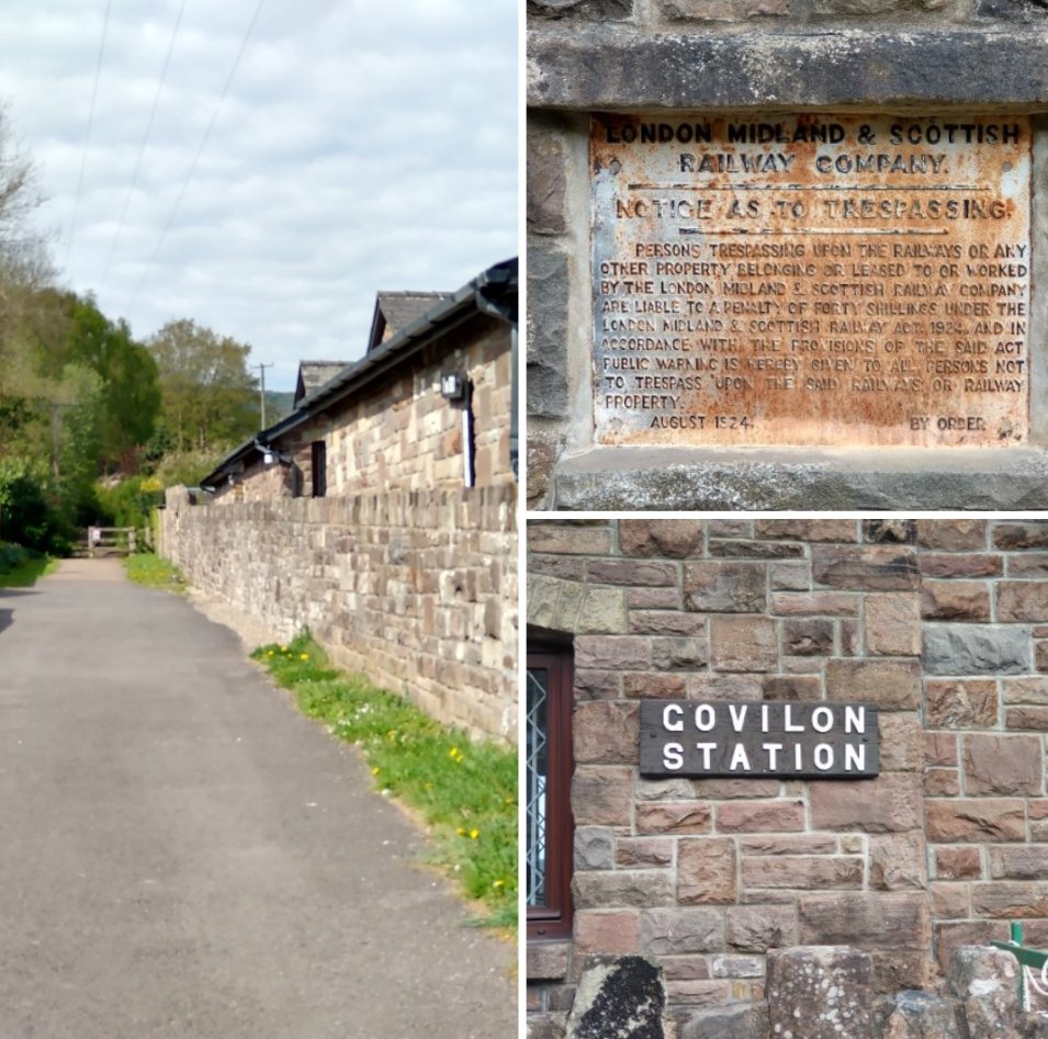
My first port-of-call was Govilon Railway Station and the information board which includes the sketch above. Govilon railway station was a station on the London and North Western Railway’s (LNWR’s) Heads of the Valleys line. After the grouping in 1923 it became part of the LMS.
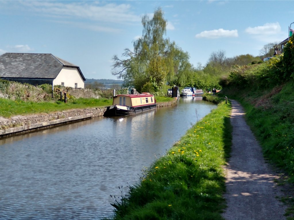
After a quick look at the station site I walked down the railway line to the point where it crossed the canal, then along the back of the site of Bailey’s Wharf. Walking over the canal bridge which is sketched by Blackmore I was the able to spend a short time at Llanvihangel (Govilon) Wharf before walking along the first few hundred yards of what was Bailey’s Tramroad.
Tramroads at Govilon
The Govilon History website tells us that “A network of tramroads were developed in the Govilon area. One of the earliest was the Blorenge Quarries Tramroad built as a plateway around 1795. Due to geological problems the Blorenge Limestone Quarry soon closed and the tramroad fell out of use by 1804.” [1]
The Blorenge Quarries Tramroad was the precursor to three other tramways which were established in the first quarter of the 19th century. Bailey’s Tramroad was one of these.
“In October 1820, Crawshay Bailey applied to the Brecon and Abergavenny Canal Company for the construction of “…a railway from the canal at Llanwenarth to our iron furnaces at Nantyglo”. It took just 7 months to build the twin track tramway. Much of the route into Govilon is still plainly visible with School Lane following the original route. Despite the mountainous route from Nantyglo the tramway managed to keep to a shallow gradient throughout its length. Siop Newydd, just outside the village, was a smithy serving the tramroad. At its peak up to 14 blacksmiths were employed for repairs and maintenance. This included shoeing horses used to pull the trams. The path of the tramway is clearly recognisable here, along with the many sidings to accommodate trams.” [1]
Other highly significant tramways in the area included:
The Llanvihangel Tramroad which initially ran from Llanfoist to Llanvihangel Crucorney. In 1818 it was extended to Govilon wharf and to Grosmont. Ultimately, this tramroad extended all the way to Hereford.
The Blaenavon Ironworks Tramroad ran from Pwlldu to the Ironworks. It was completed in around 1815. Worthy of note is a 1.5 mile tunnel as part of the length of the Tramroad connecting Blaenavon with Pwlldu.
Bailey’s Tramroad
Bailey’s Tramroad was of 4′ 4″ gauge, or thereabouts. [2] Later in this article is a description of my walk back along the route of the old Tramroad.
The Heads of the Valley Line and Govilon Railway Station.
The Wikipedia article about Govilon Railway Station [3] tells us that “the first section of the Merthyr, Tredegar and Abergavenny Railway (MTAR) from Abergavenny to Brynmawr was opened on 29 September 1862. [4: p18] The line was leased and operated by the London and North Western Railway (LNWR) which acquired the smaller railway company on 30 June 1866. [5: p93][6: p63] The LNWR was itself amalgamated into the London, Midland and Scottish (LMS) Railway in the 1923 Grouping.” [5: p88-89]
Govilon Railway Station opened on 1 October 1862, [7: p191][8: p107] a couple of days after the ceremonial opening of the first section of the railway. It was the first station beyond Abergavenny Brecon Road. [9] The 1st October was also the first day of the LNWR’s lease of the line. [10: p112] There is a possibility that Govilon was the first station opened on the line because of its proximity to Llanfoist House, the residence of Crawshay Bailey who by this time was a director of the MTAR. [2: p20]
Wikipedia notes that “Decline in local industry and the costs of working the line between Abergavenny and Merthyr led to the cessation of passenger services on 4th January 1958. [4: p139][6: p68] The last public service over the line was a Stephenson Locomotive Society railtour on 5th January 1958 hauled by LNWR 0-8-0 No. 49121 and LNWR Coal Tank No. 58926. [4: p139][11: fig. 65] Official closure came on 6 January.” [3][7: p184][12: p55][8: p107][13: p191]
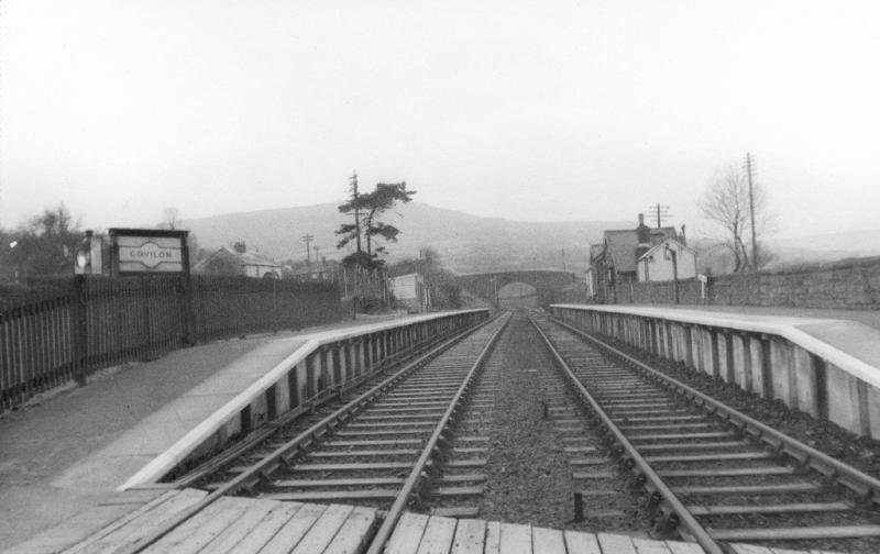
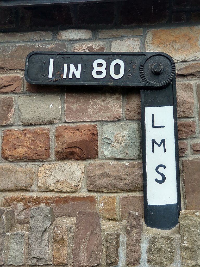
Govilon Railway Station was “situated on a steep 9-mile (14 km) climb from Abergavenny at gradients as severe as 1 in 34. [6: p68][13: p164] A gradient post showing 1 in 80 /1 in 34 was installed on one of the station platforms.” [3][4: p116]
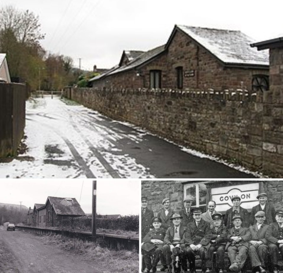
This gradient marker is present on the wall of the old station building. It does not quite match the gradient marker which was originally present. The original gradient marker highlighted a change in gradient from 1 in 80 to 1 in 34. (My photograph, 25th April 2022)
The low stone-built station building was on the Up platform There was a station house behind it. [4: p116][11: fig. 41]. A single siding separated the station building from the station house. It “served a small goods yard until after the First World War” [3][11: fig. 41] Wildon Ironworks was on the opposite side of the main platforms and was served by a siding from 1885 to 1941.[11: fig. VIII]
The Wikipedia article continues: “to the west was a small goods shed and road bridge. [11: fig. 42] A third siding was situated 400 yards (370 m) to the east which led to a wharf on the Monmouth and Brecon Canal until 1953. [11: fig. VII] No. 1 signal box was opened in 1911 near the canal wharf and lasted until c. 1930. [12: fig. 36] No. 2 box was erected at the east end of the Down platform in 1877; it controlled the road crossing to the east of the station.” [11: fig. 38][3]
The Walk from Govilon Railway Station to Bailey’s Wharf
The next few pictures were taken on the short walk from the railway station to the wharf.
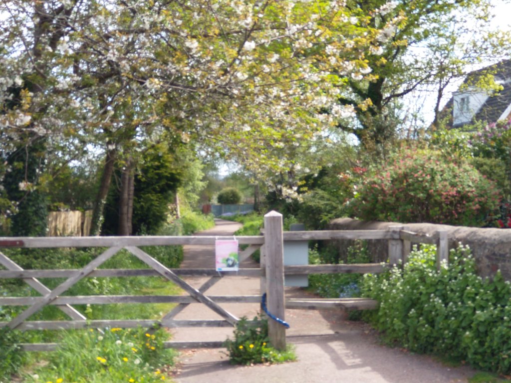
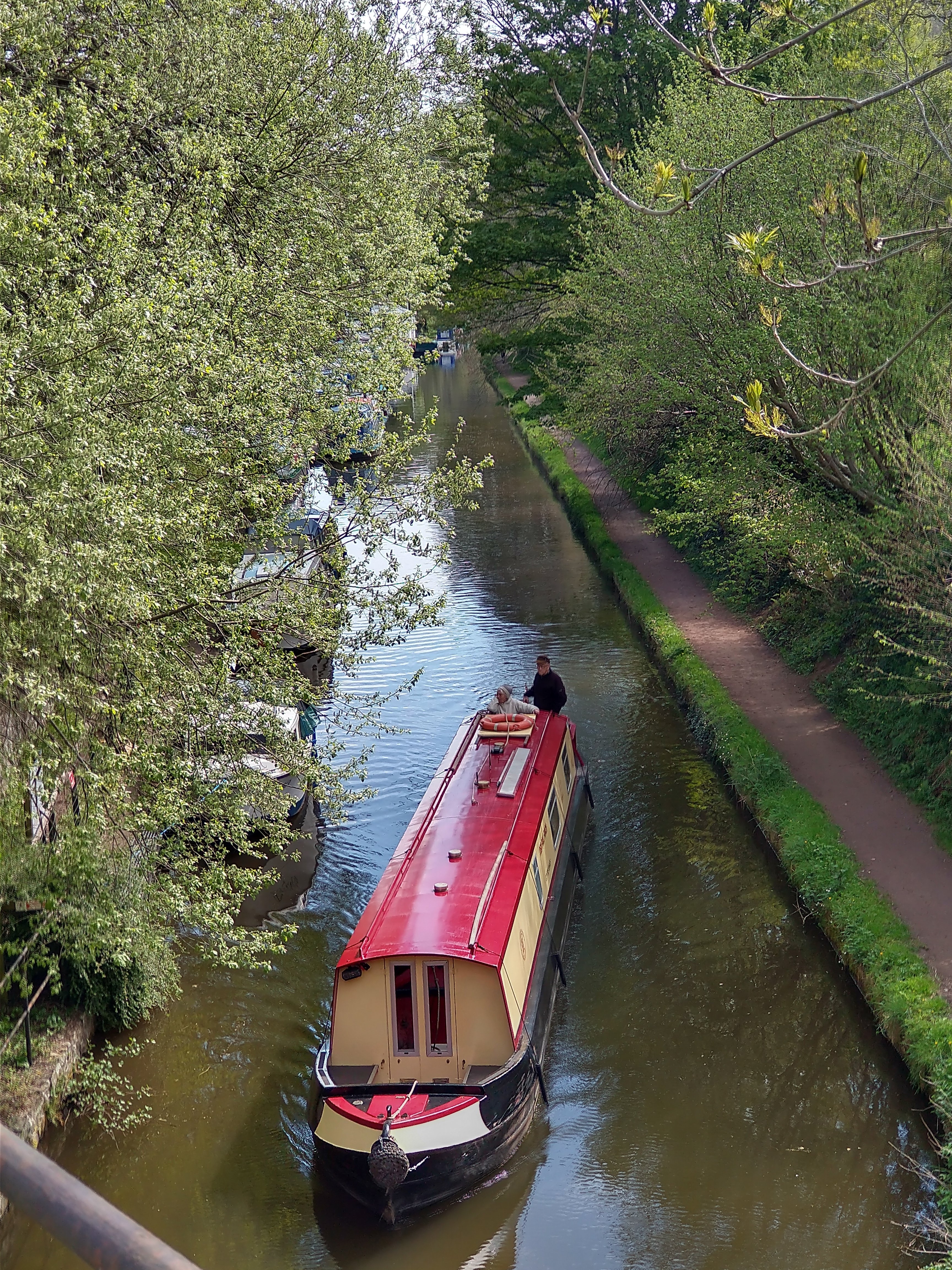
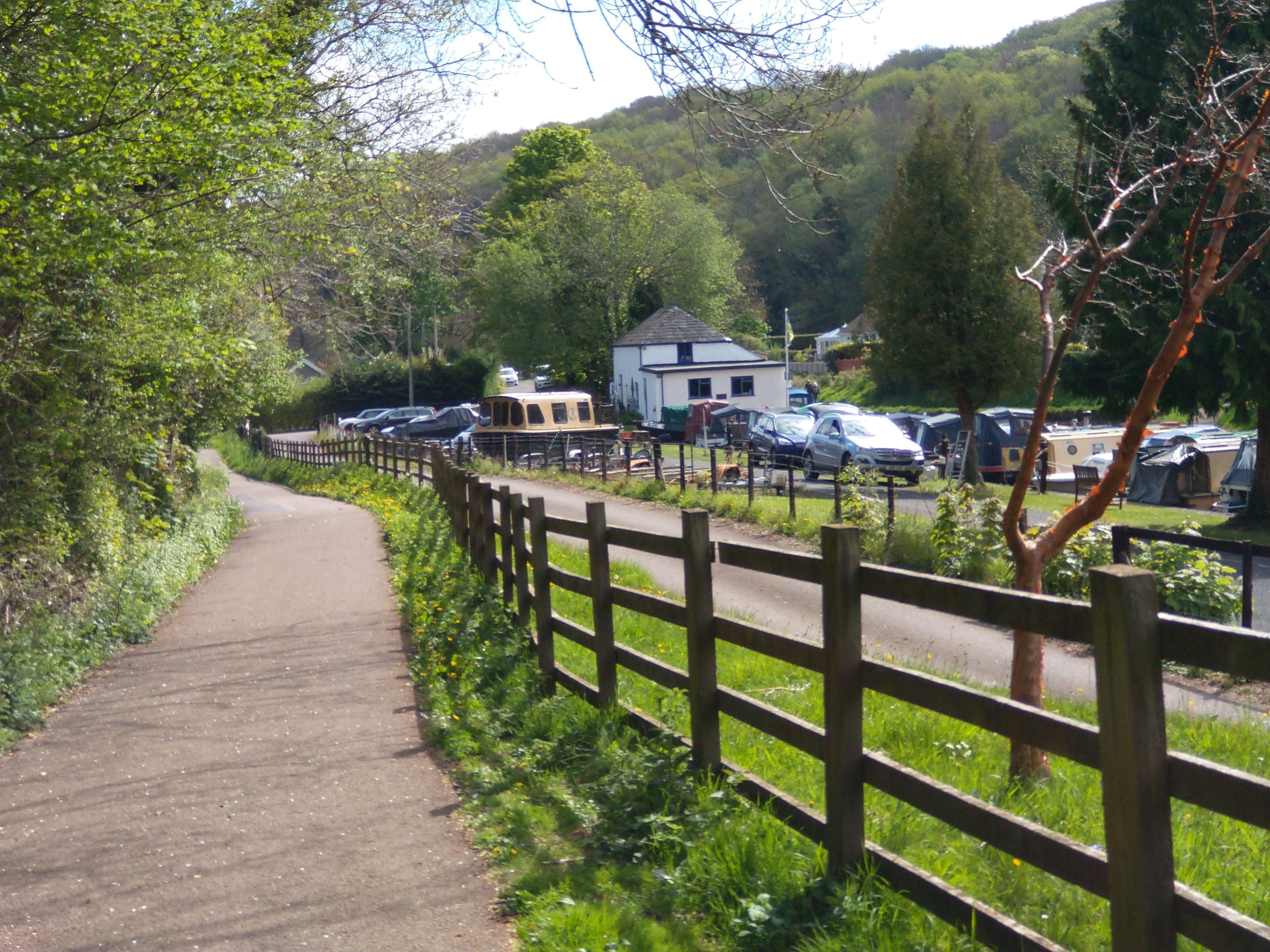
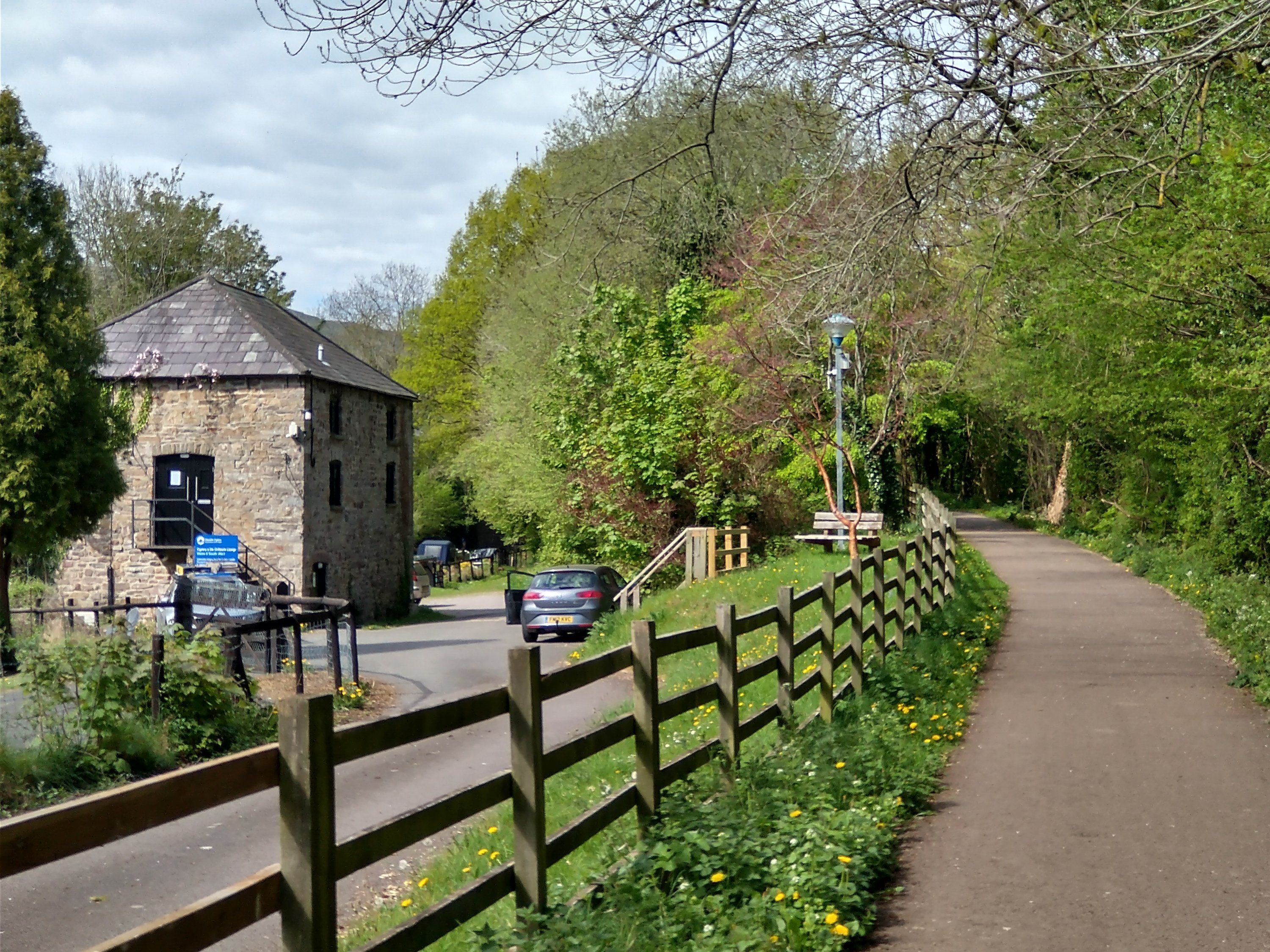
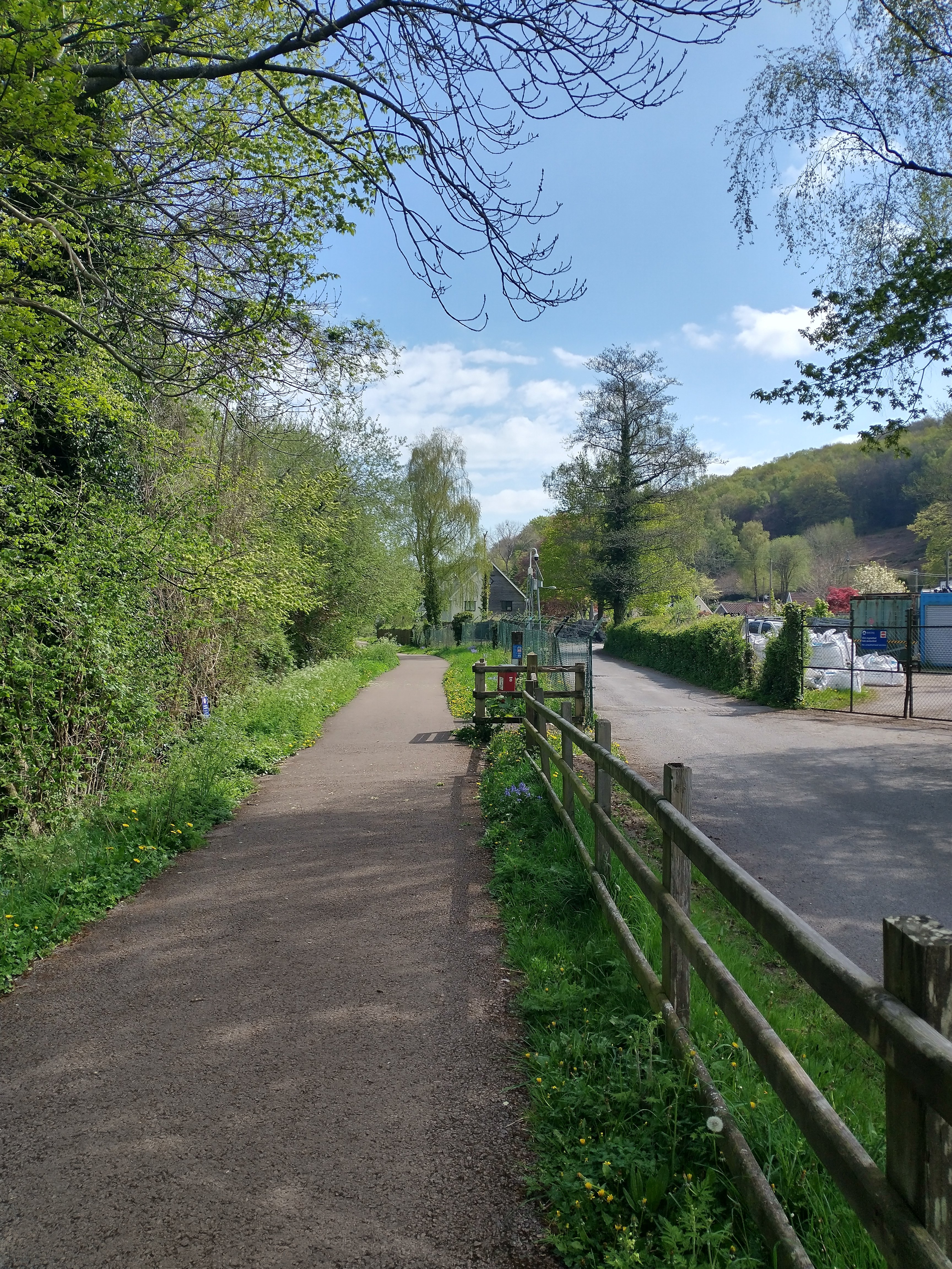
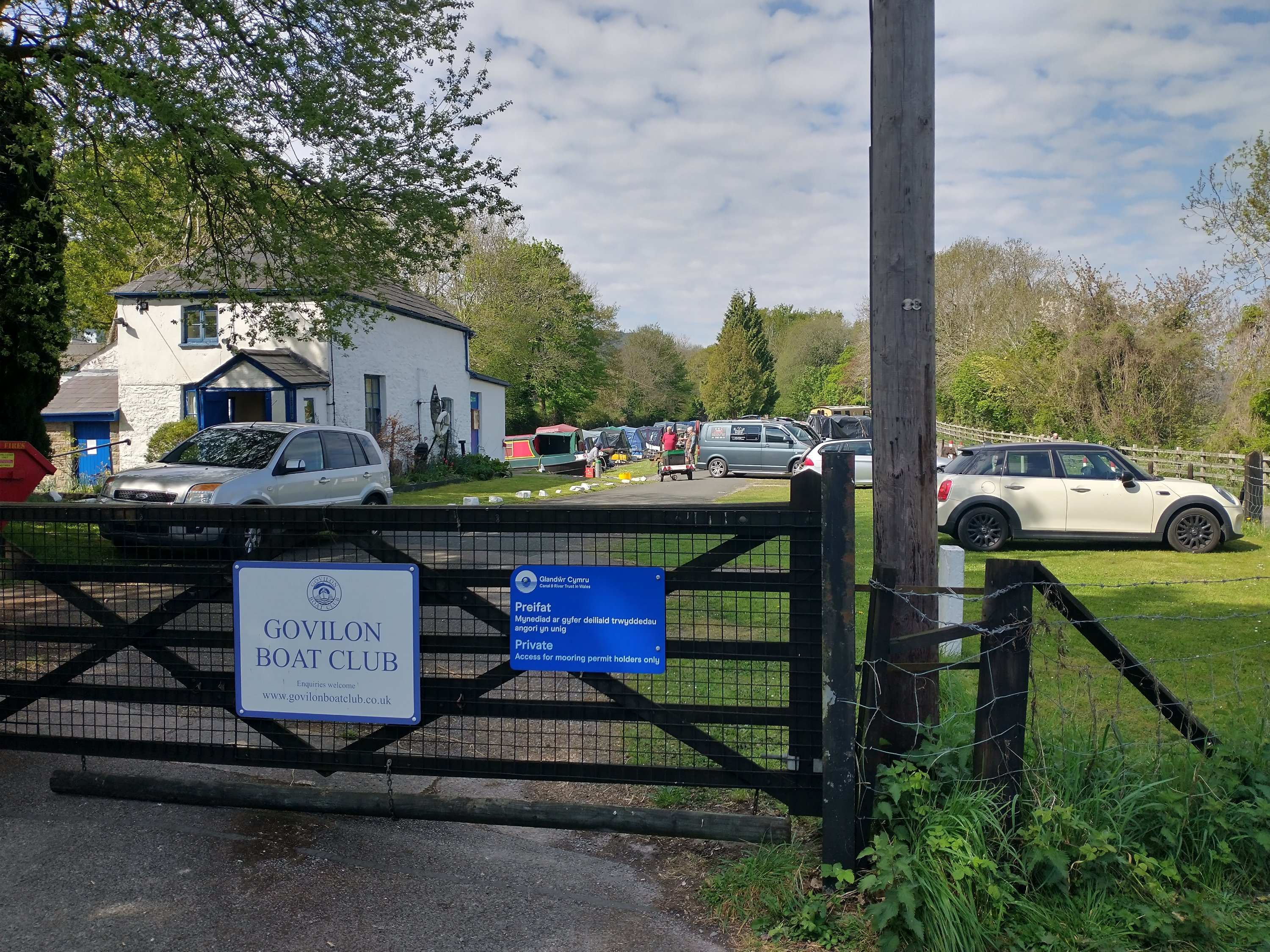
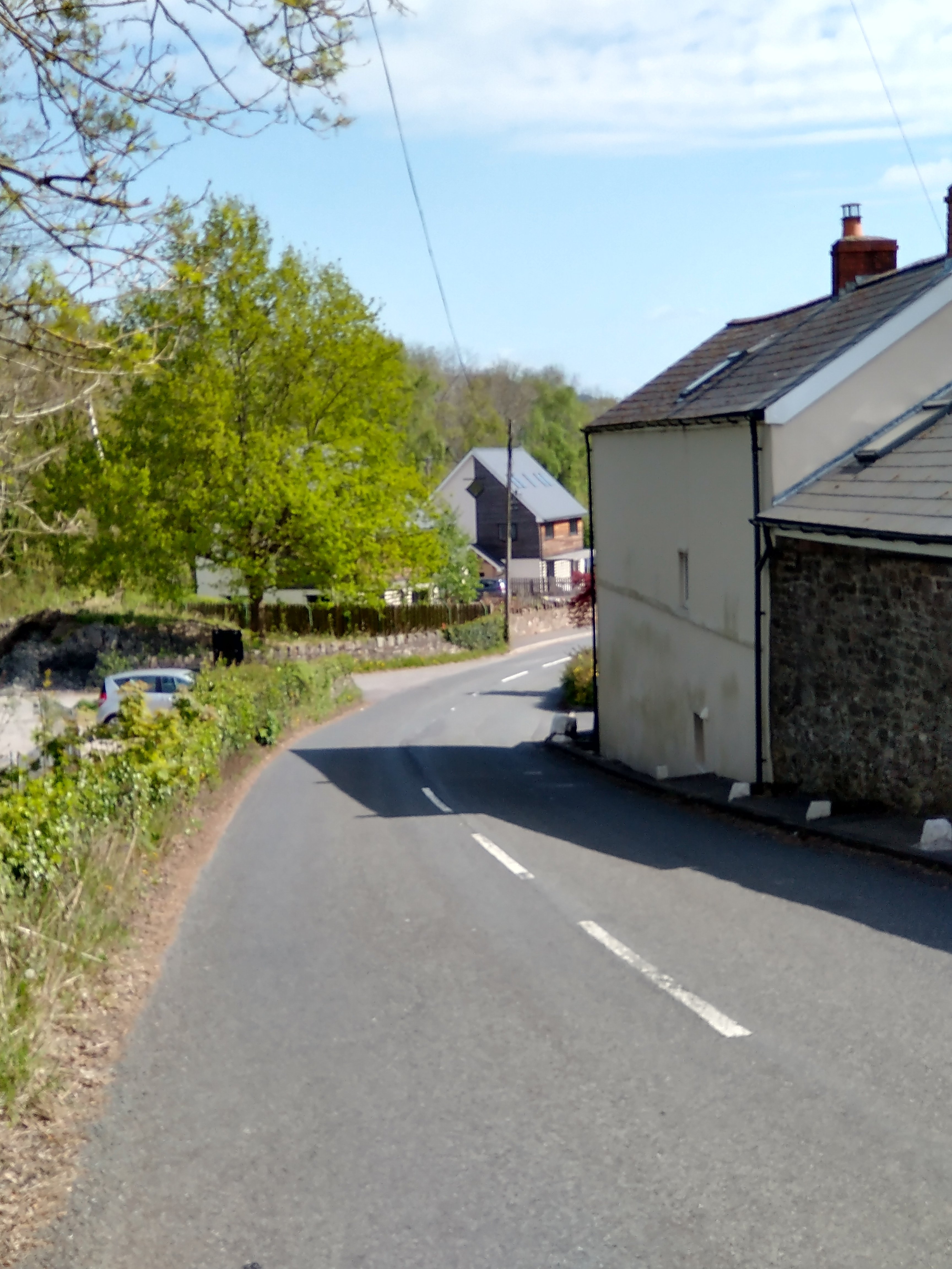
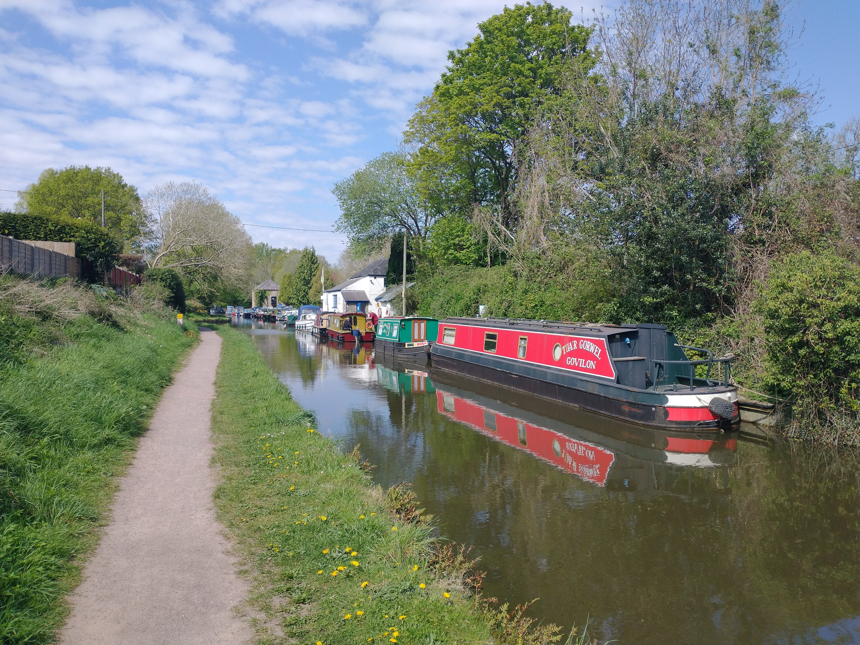
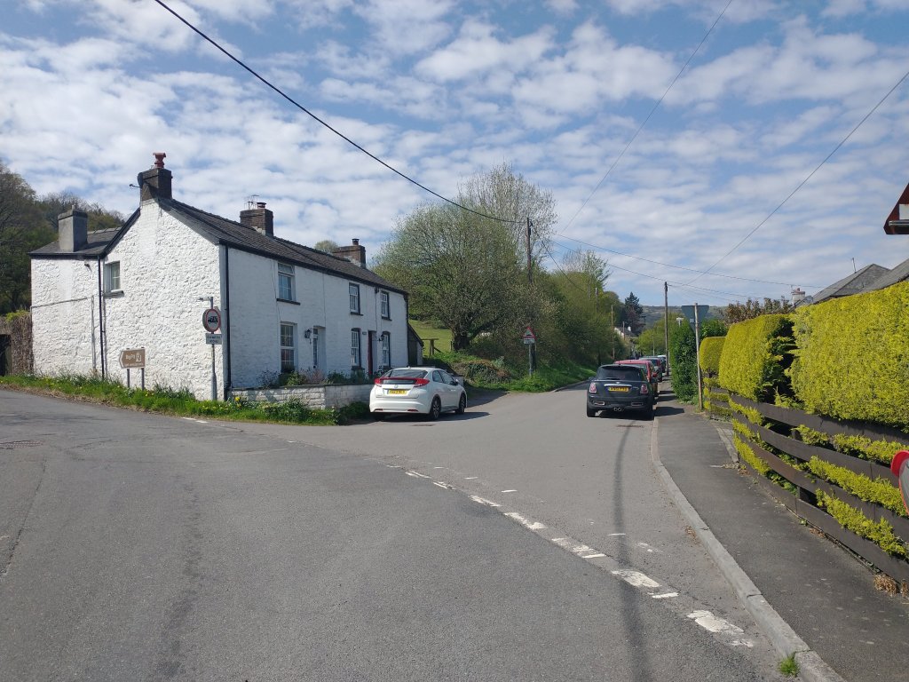
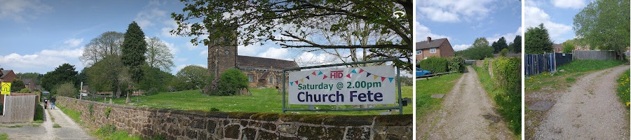
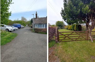
The view facing Abergavenny from Derwen Deg, the road which crossed the old line at the station throat. (My photograph, 25th April 2022)Looking west towards Govilon Railway Station and the footpath gate at Derwen Deg. (My picture, 25th April 2022]Looking towards the Canal Bridge and Abergavenny (My photograph, 25th April 2022)Looking West along the Canal from the old railway bridge. (My picture, 25th April 2022)Looking East from the old railway bridge towards Bailey’s Wharf and Abergavenny. (My photograph, 25th April 2022)Looking back across the location of the railway bridge over the Canal to the West and the path leading back to Govilon Railway Station. (My picture, 25th April 2022)Looking towards Bailey’s Wharf from close to the bridge over the Canal. (My photograph, 25th April 2022)Looking towards Abergavenny along Bailey’s Wharf from the old railway. (My photograph, 25th April 2022)A photograph from the same location as that immediately above, looking back towards Govilon Railway Station. The stone building on the left of the image is Bailey’s Warehouse. (My picture, 25th April 2022)The railway continued beyond the Wharf heading for Abergavenny. (My picture, 25th April 2022)Govilon Boat Club now occupies the site of Bailey’s Wharf. The gate sits on the approximate line of Bailey’s Tramroad as it entered the site. Its route from the canal bridge is behind the camera. (My photograph, 25th April 2022)
Llanvihangel Wharf
We have already noted that the Llanvihangel Railway was an early horse-drawn railway line. It operated over a 6.25 mile route between the Canal at Govilon and Llanvihangel Crucorney from 1814 until 1846.
Along with two other tramways it created a line that reached all the way to Hereford. In 1846 all three Tramroads were sold in 1846 to the Newport, Abergavenny and Hereford Railway Company. The Llanvihangel Railway fetched a price of £21,750 (equivalent to close to £2.2 million in 2022). [15][16] The company replaced them with a standard-gauge steam railway.[15][17]
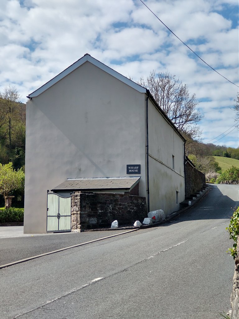
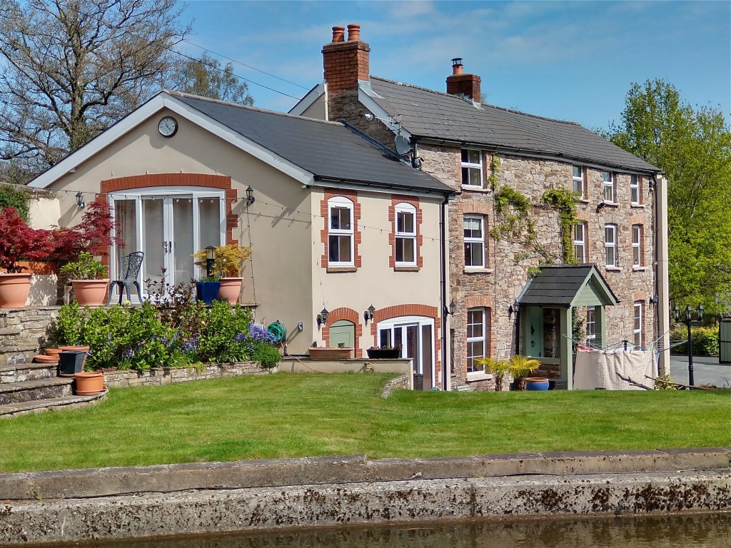
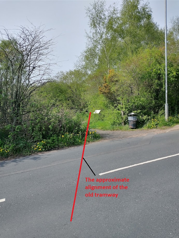
The Llanvihangel Tramroad Wharf was to the East of the road bridge at the East end of Bailey’s Wharf. A short walk from the Heads of the Valley Line, along an access road allows one to each the back of Wharf House immediately to the East of the road bridge.
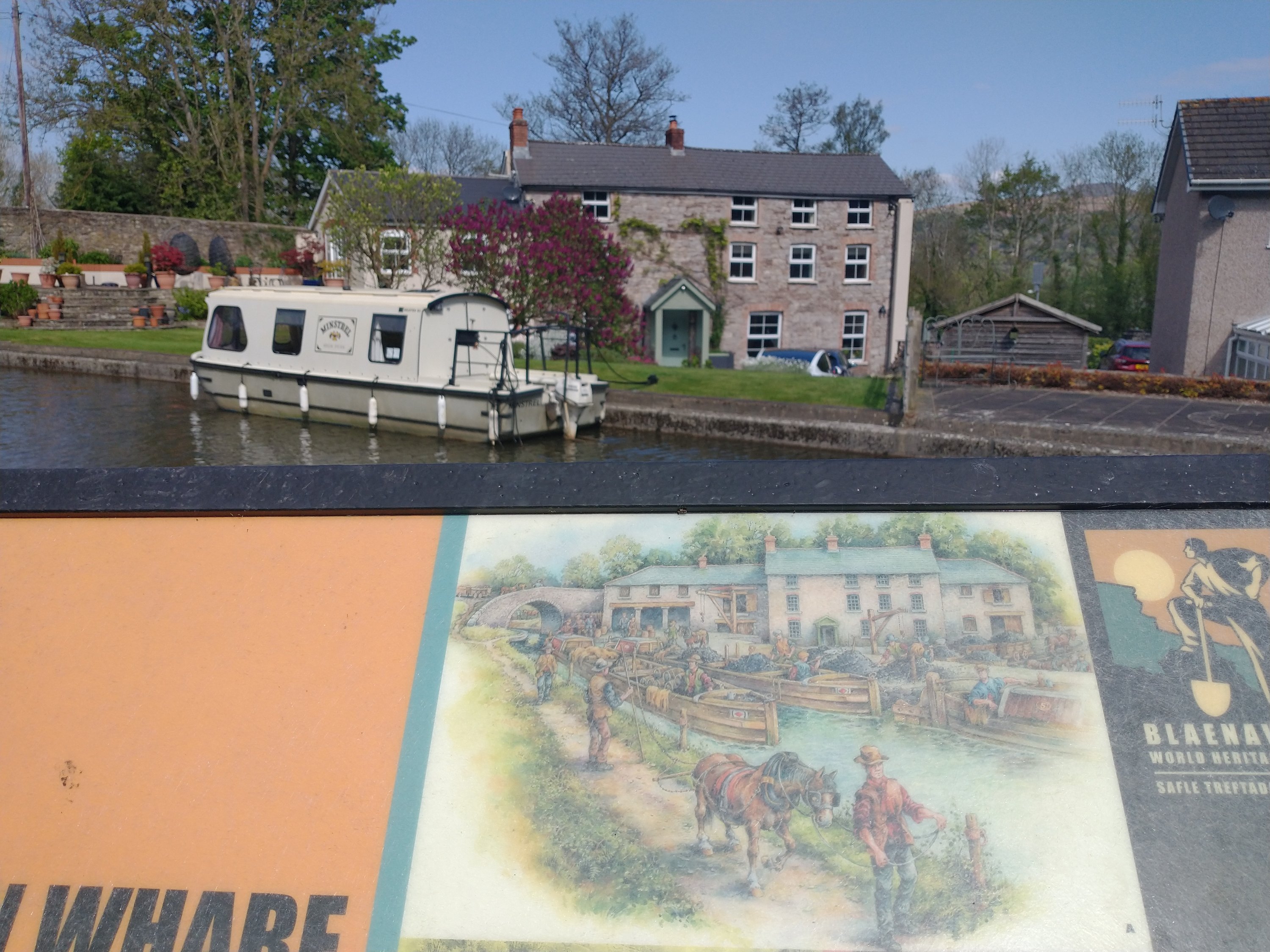
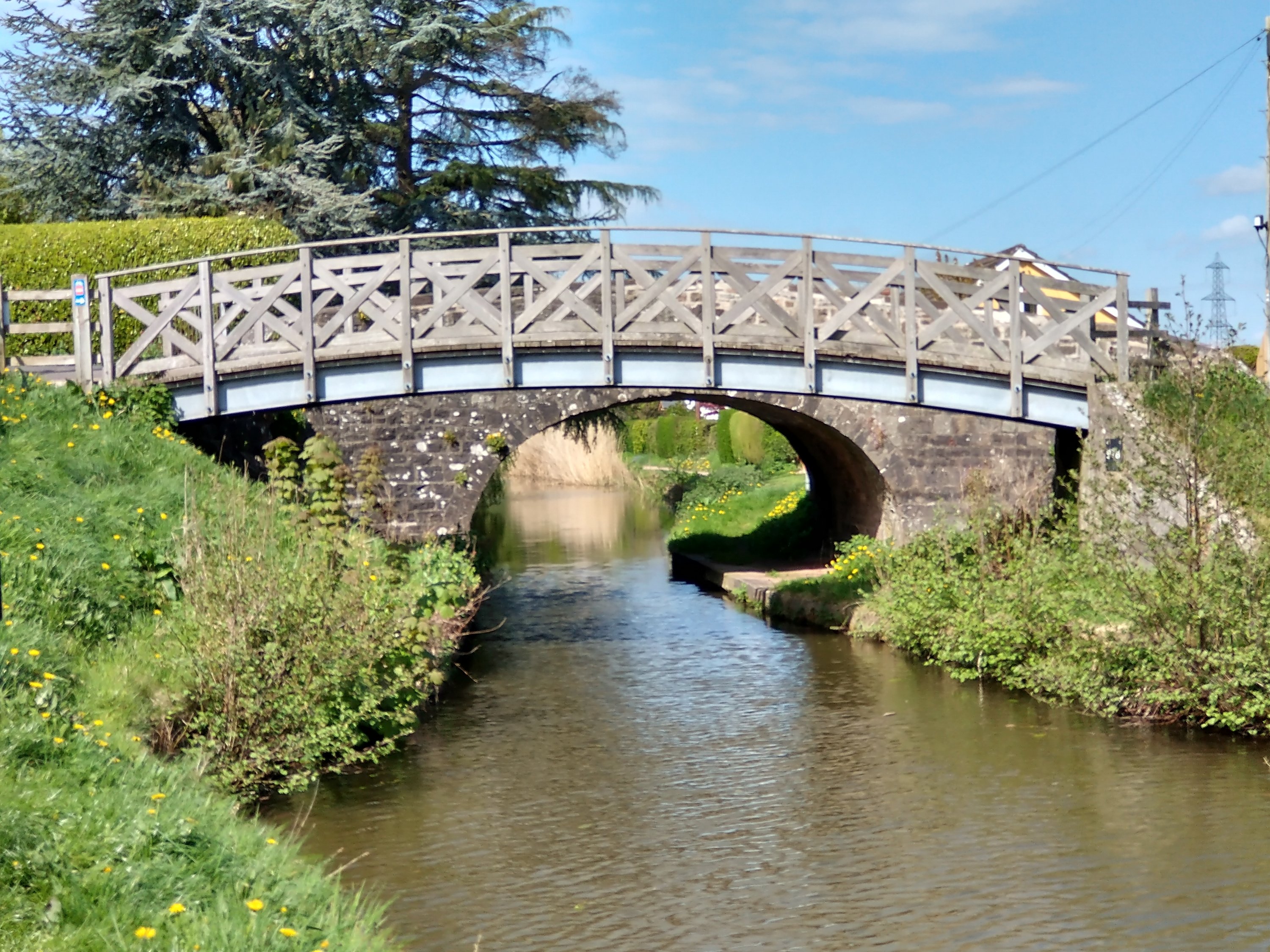
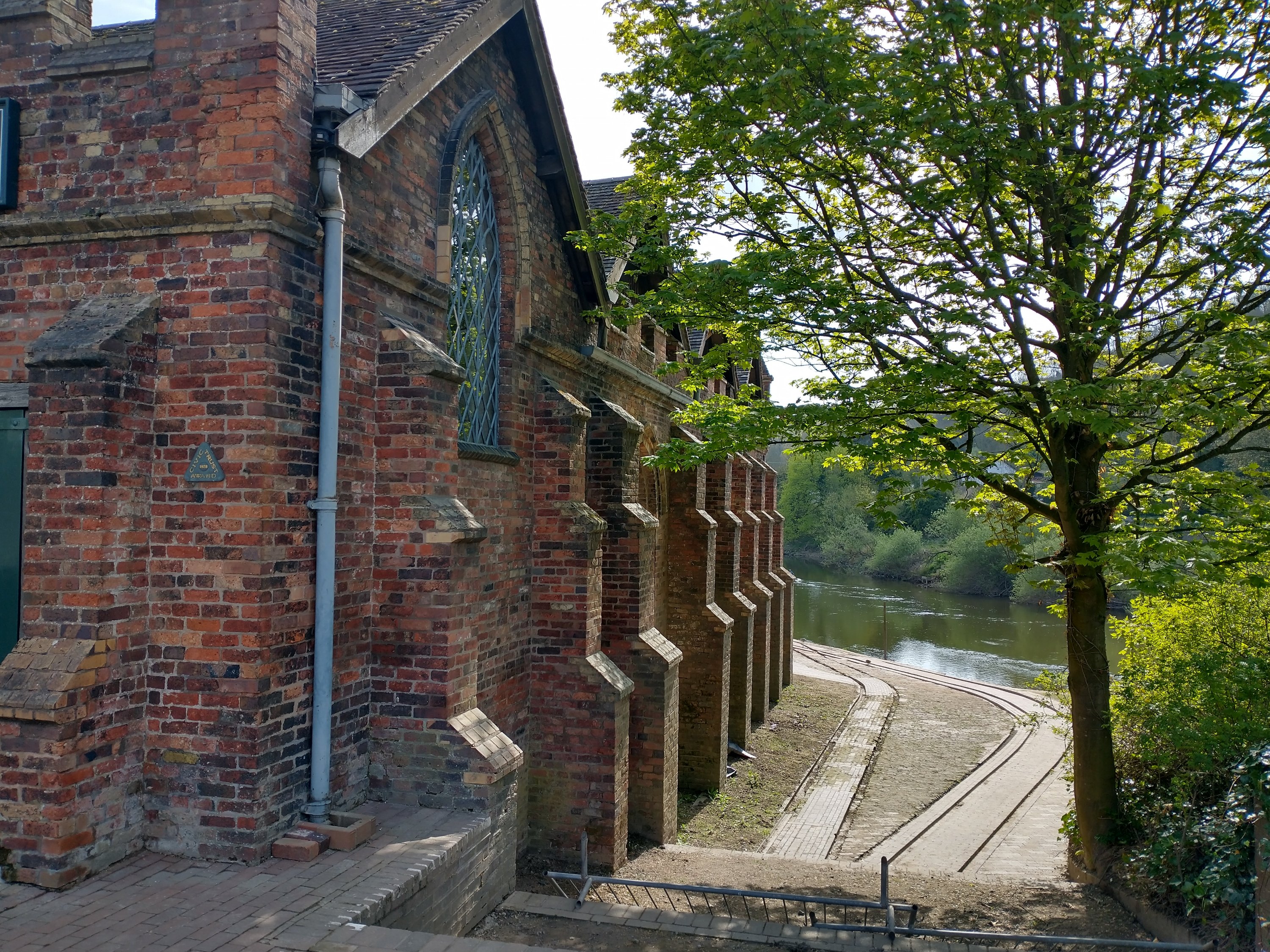
Looking Southwest along Blaenavon Road towards the bridge over the Canal showing the rear of Wharf House. (My photograph, 25th April 2022)Looking Northeast along Blaenavon Road from the bridge over the Canal also showing the rear of Wharf House. (My photograph, 25th April 2022)The Southeast face of Wharf House in April 2022. The picture was taken from the far side of the Canal. (My photograph)A view from behind the information board on the Canal towpath which shows a sketch of Wharf House as it is understood it looked in the 19th century, (Michael Blackmore) and the present condition of the building. (My photograph, 25th April 2022)A second sketch of the wharf yard (Michael Blackmore). It is also included on the information board on the Canal towpath. (My photograph, 25th April 2022)Looking East along the Canal. (My photograph)Looking West along the Canal from beneath the road bridge. (My photograph)A view of Bailey’s Wharf from the towpath on the opposite side of the Canal. (My picture, 25th April 2022)
Bailey’s Tramroad, the first few hundred metres. …
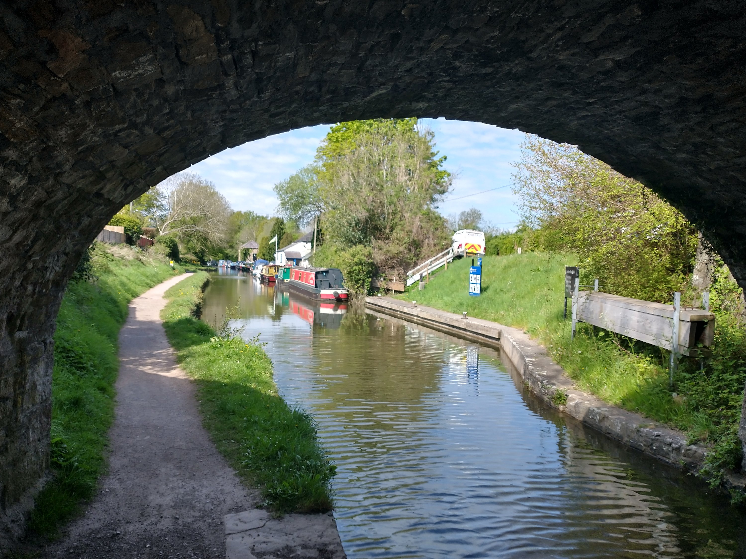
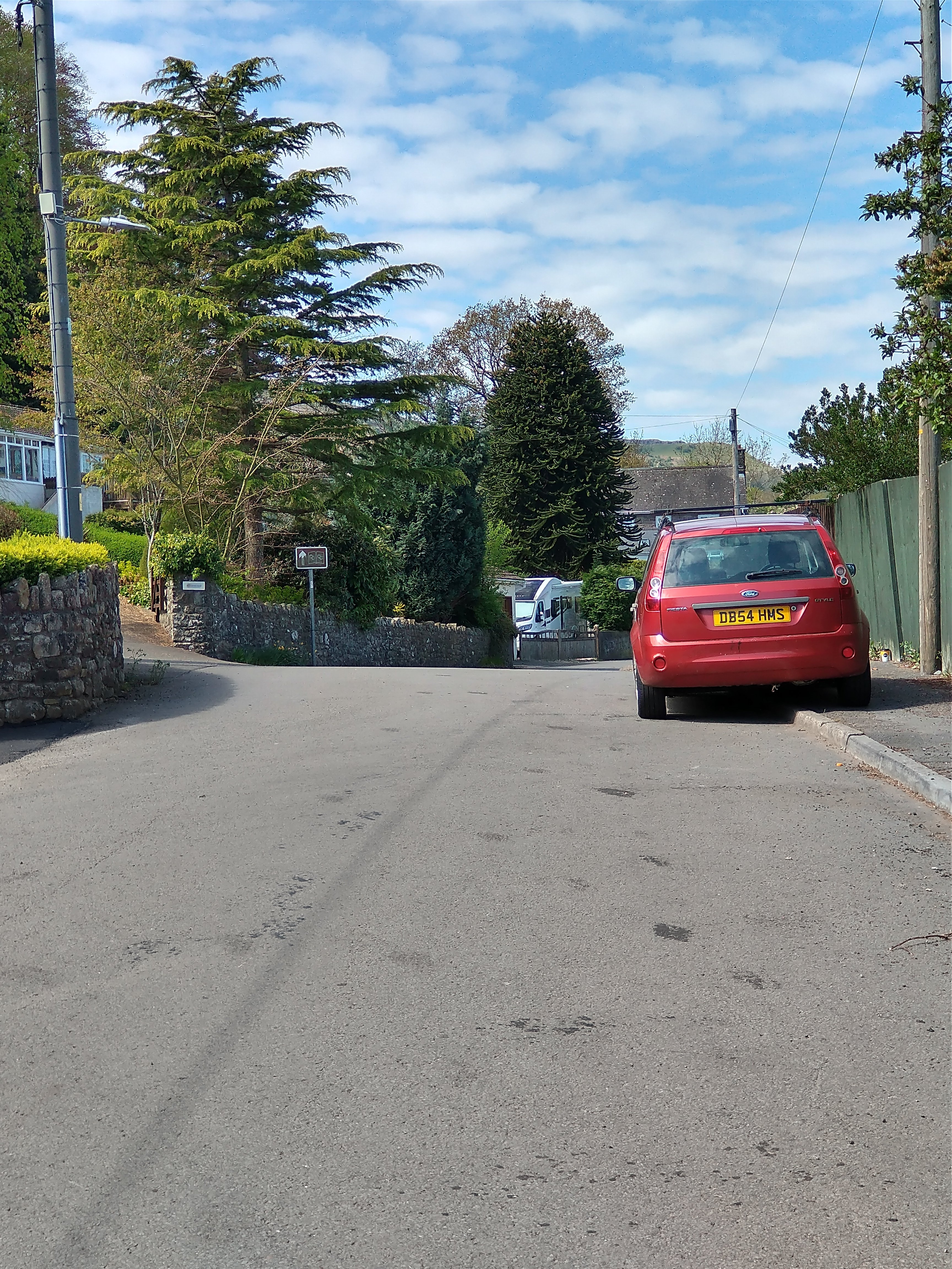
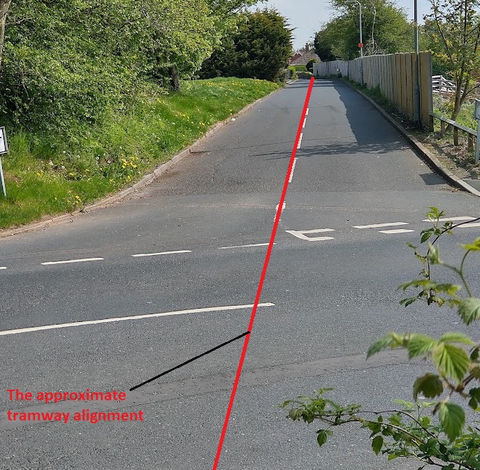
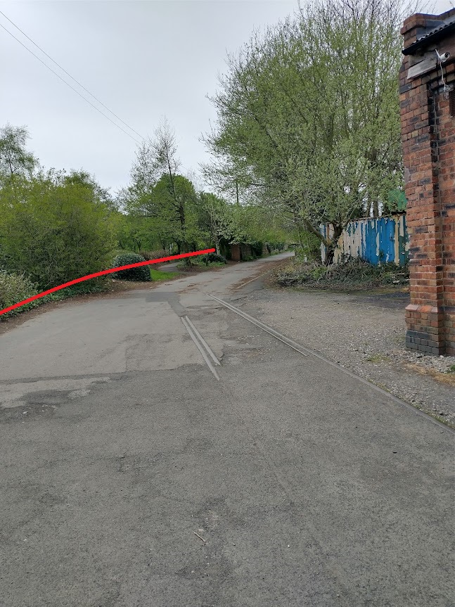
Leaving the site of Bailey’s Wharf, which we have already seen is now occupied by Govilon Boat Club, the double track Tramroad travelled a very short distance to the East before crossing the Canal at a shared road/tramroad bridge. The modern road name is Blaenavon Road.
The view West from the Canal Bridge along Blaenavon Road. (My picture, 25th April 2022)An OpenStreetMap extract which shows the Blaenavon Road (B4246) and the length of School Lane which lies on the route of Bailey’s Tramroad. [20]
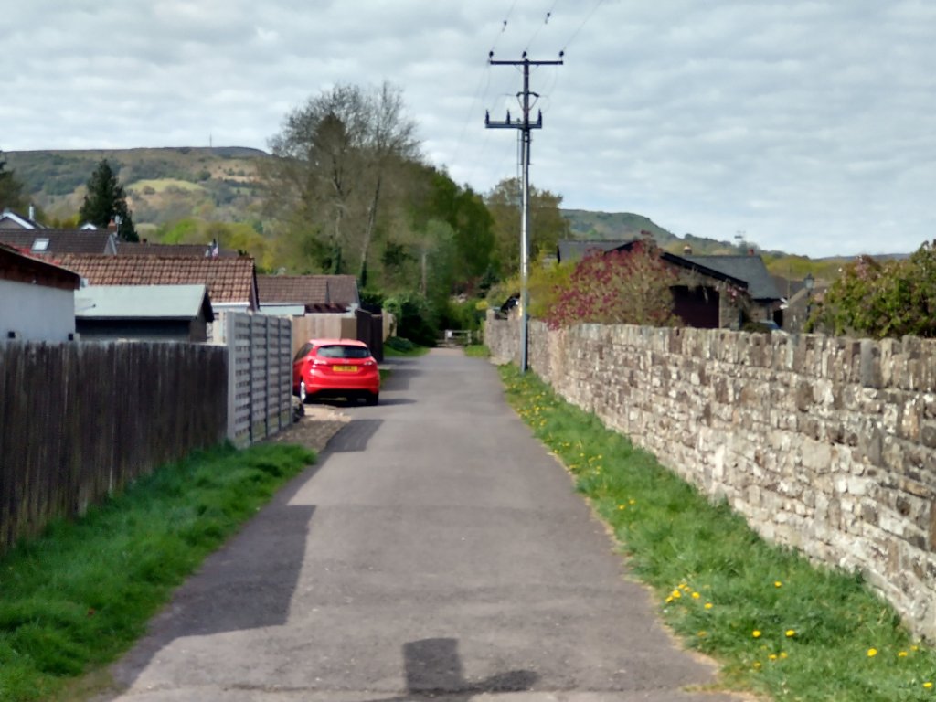
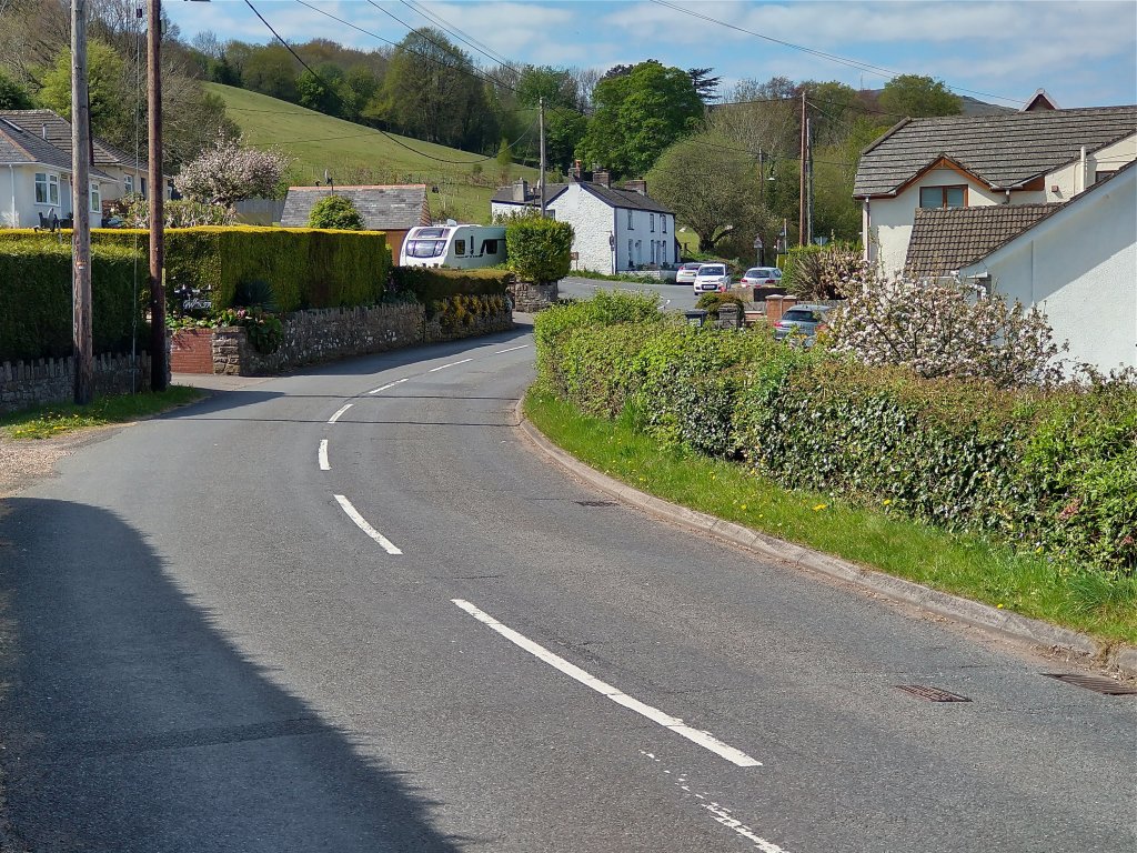
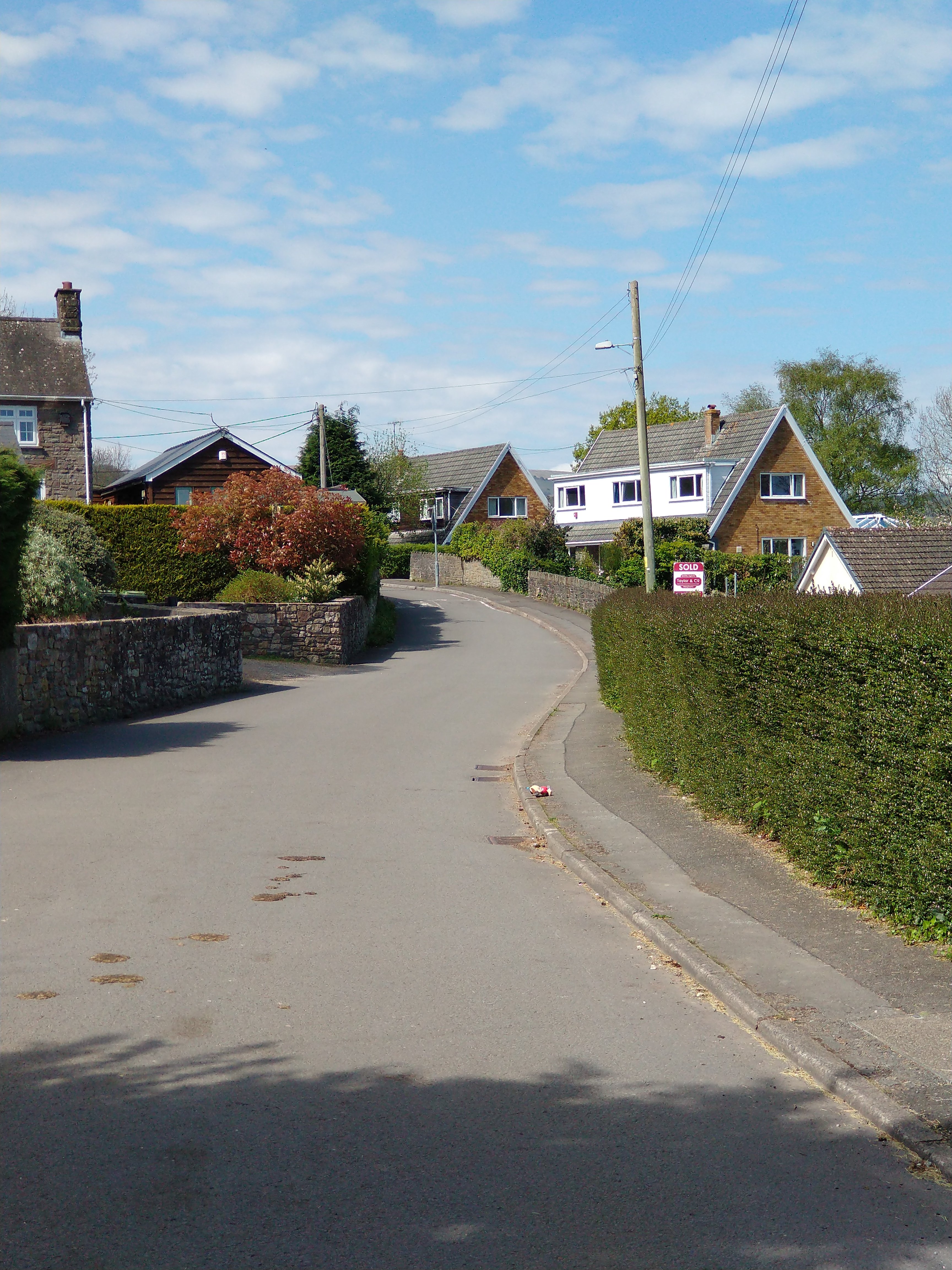
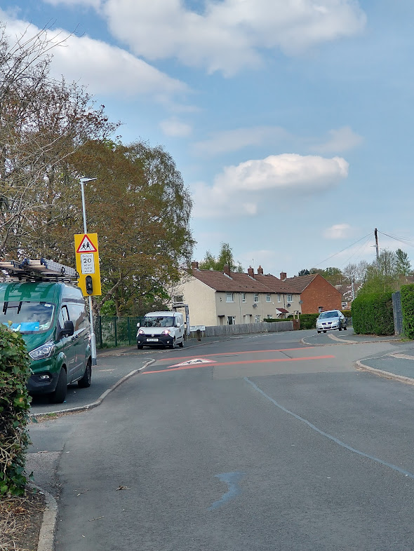
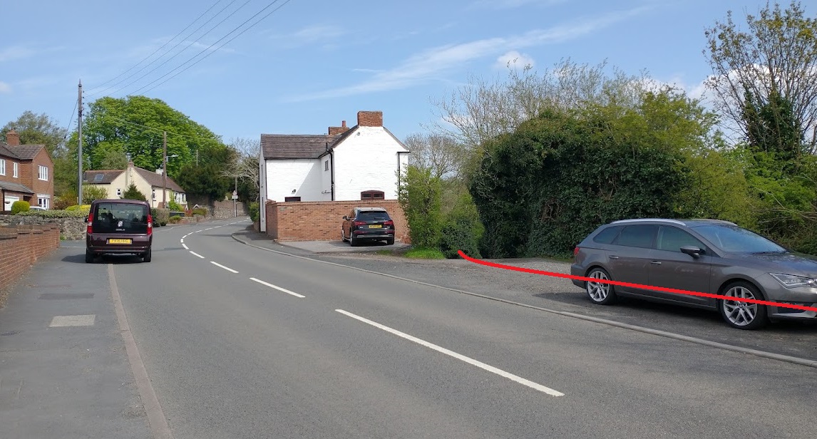
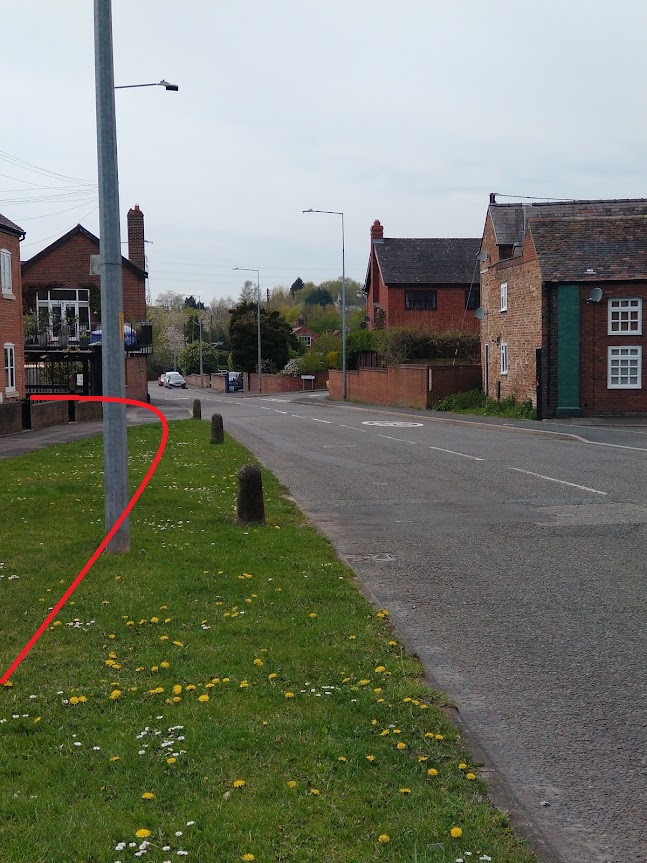
The route of the Tramroad leaves Blaenavon Road as turns sharply to the East. It runs along School Lane back towards Govilon Railway Station.
School Lane, looking West from Blaenavon Road. (My photograph, 25th April 2022)
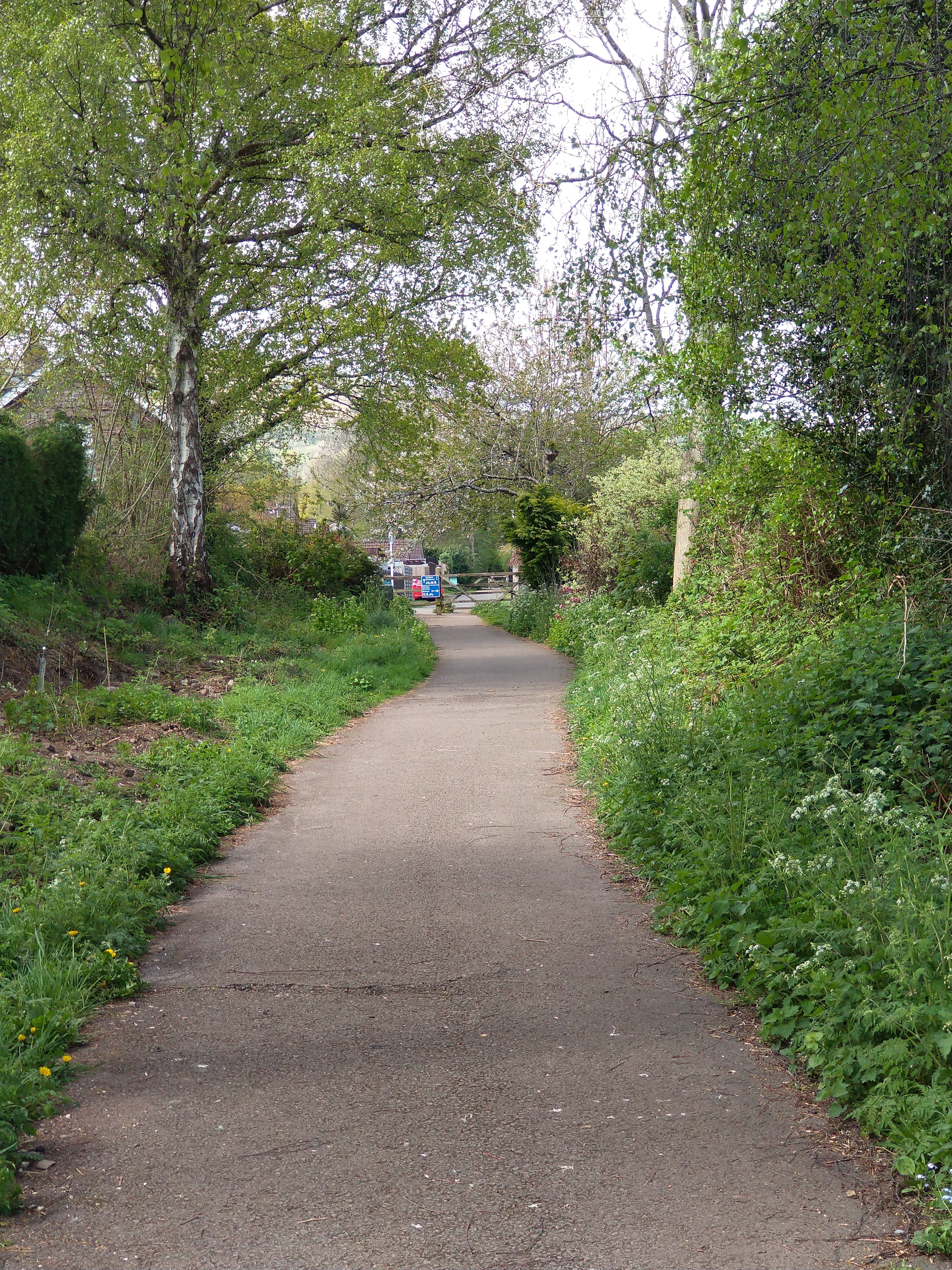
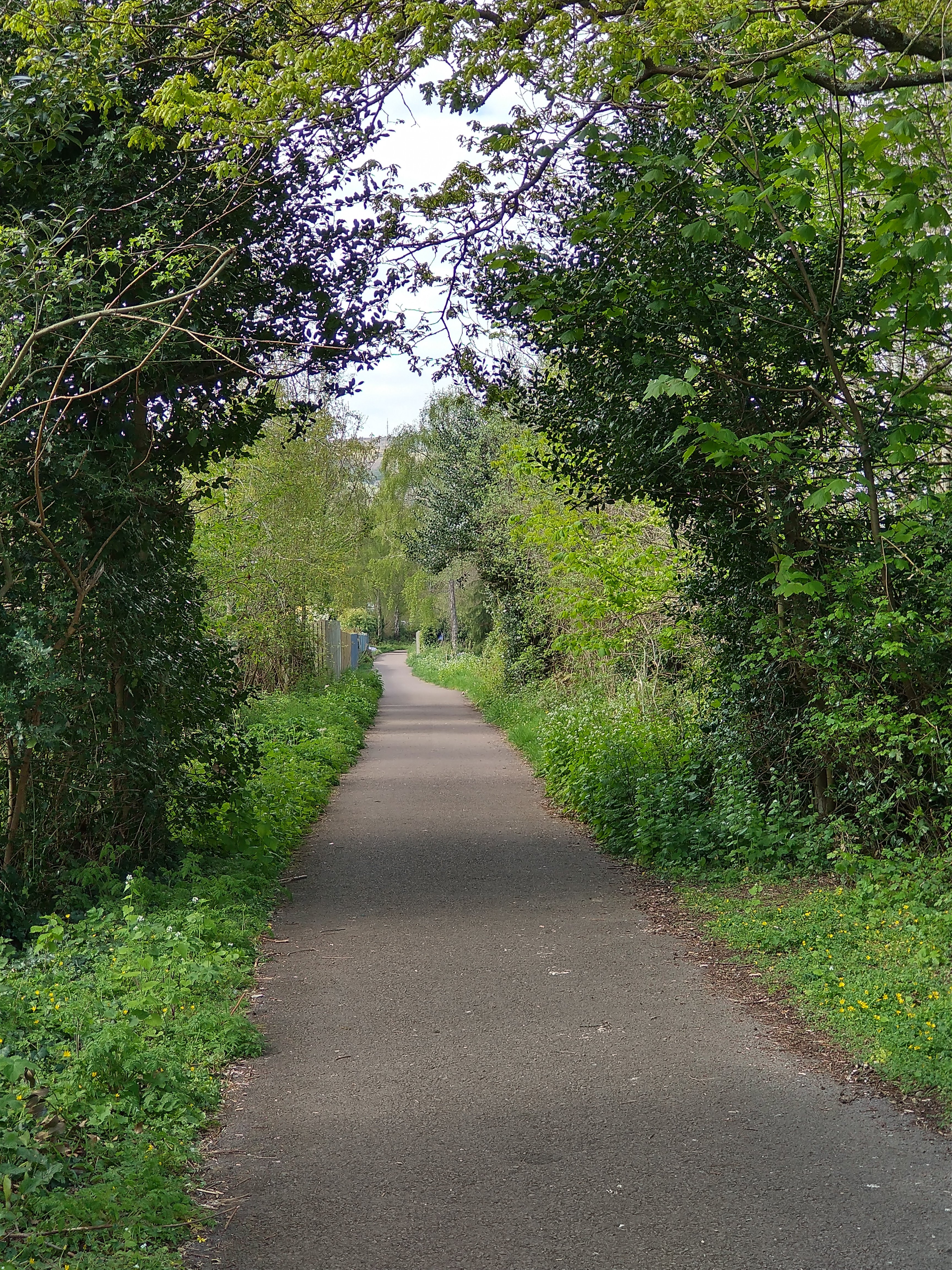
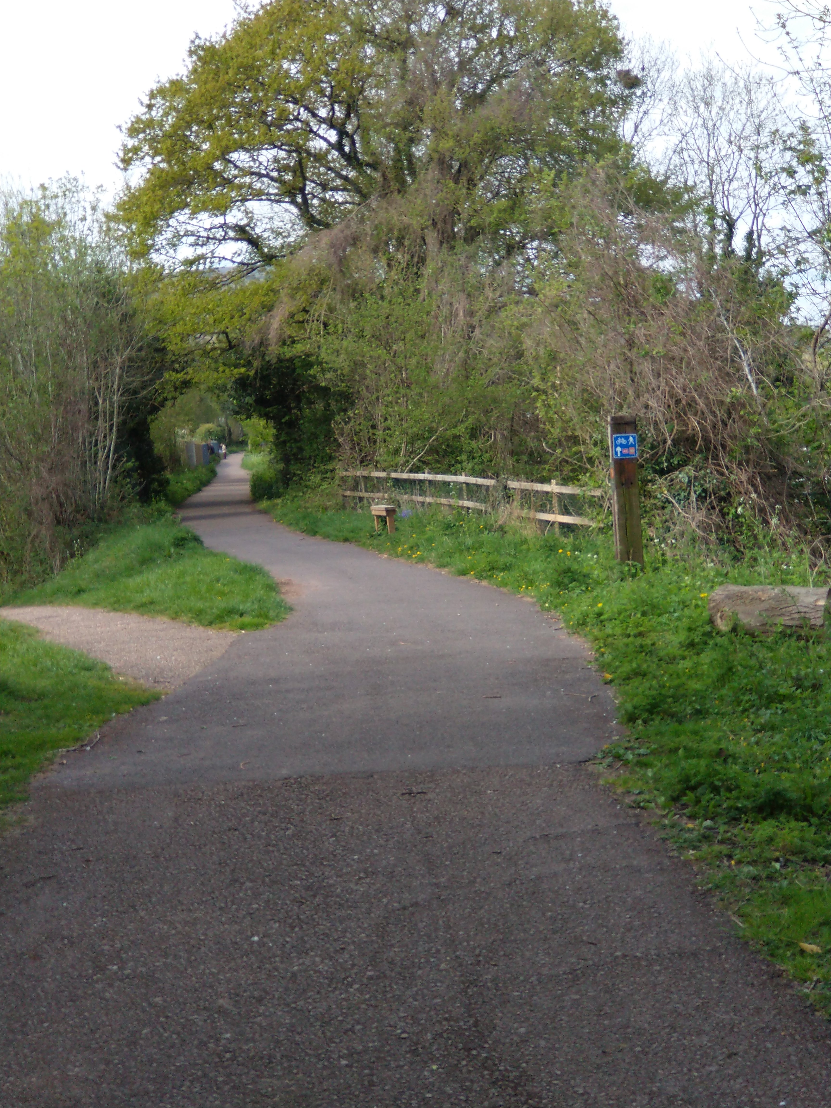
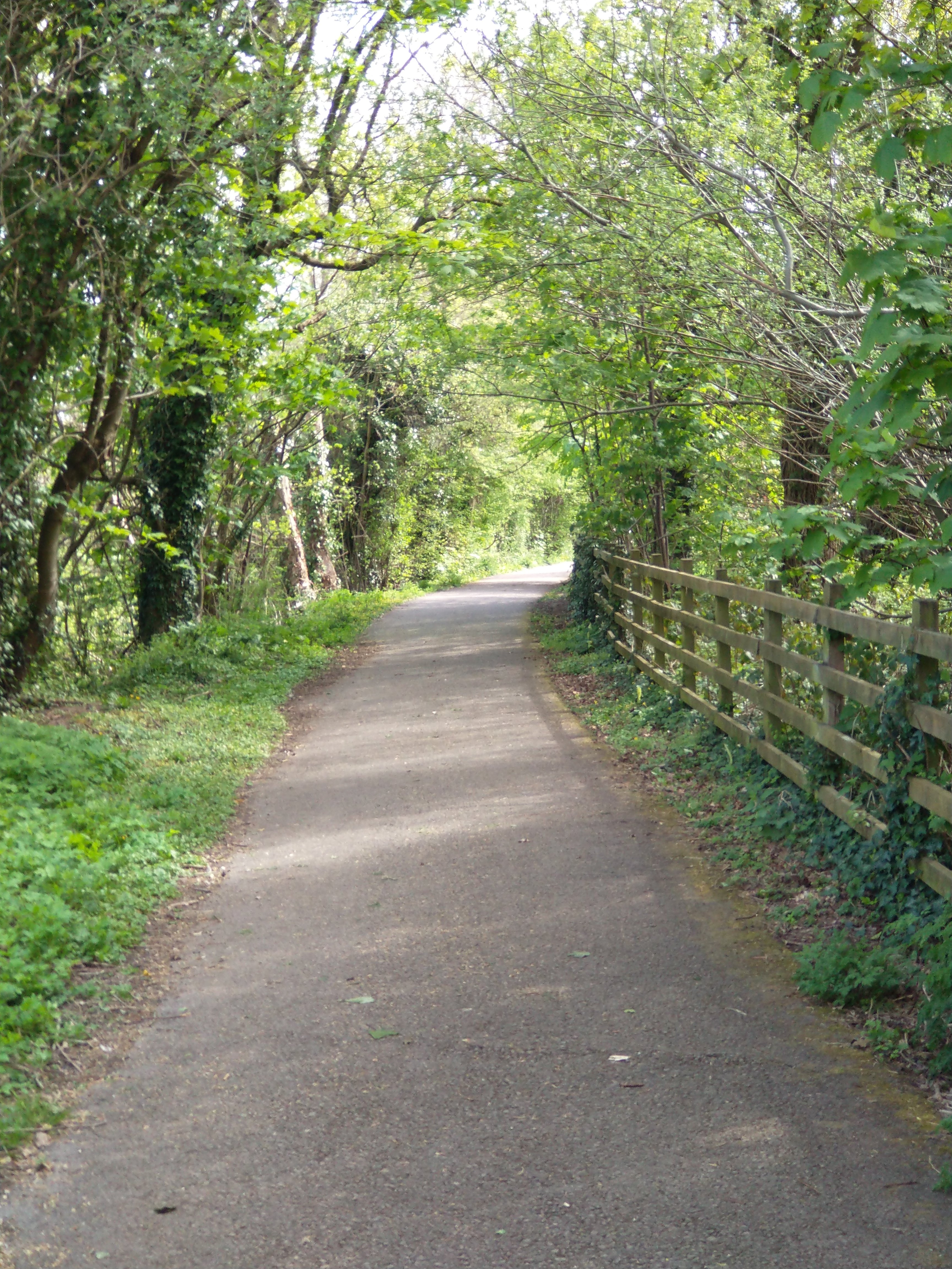
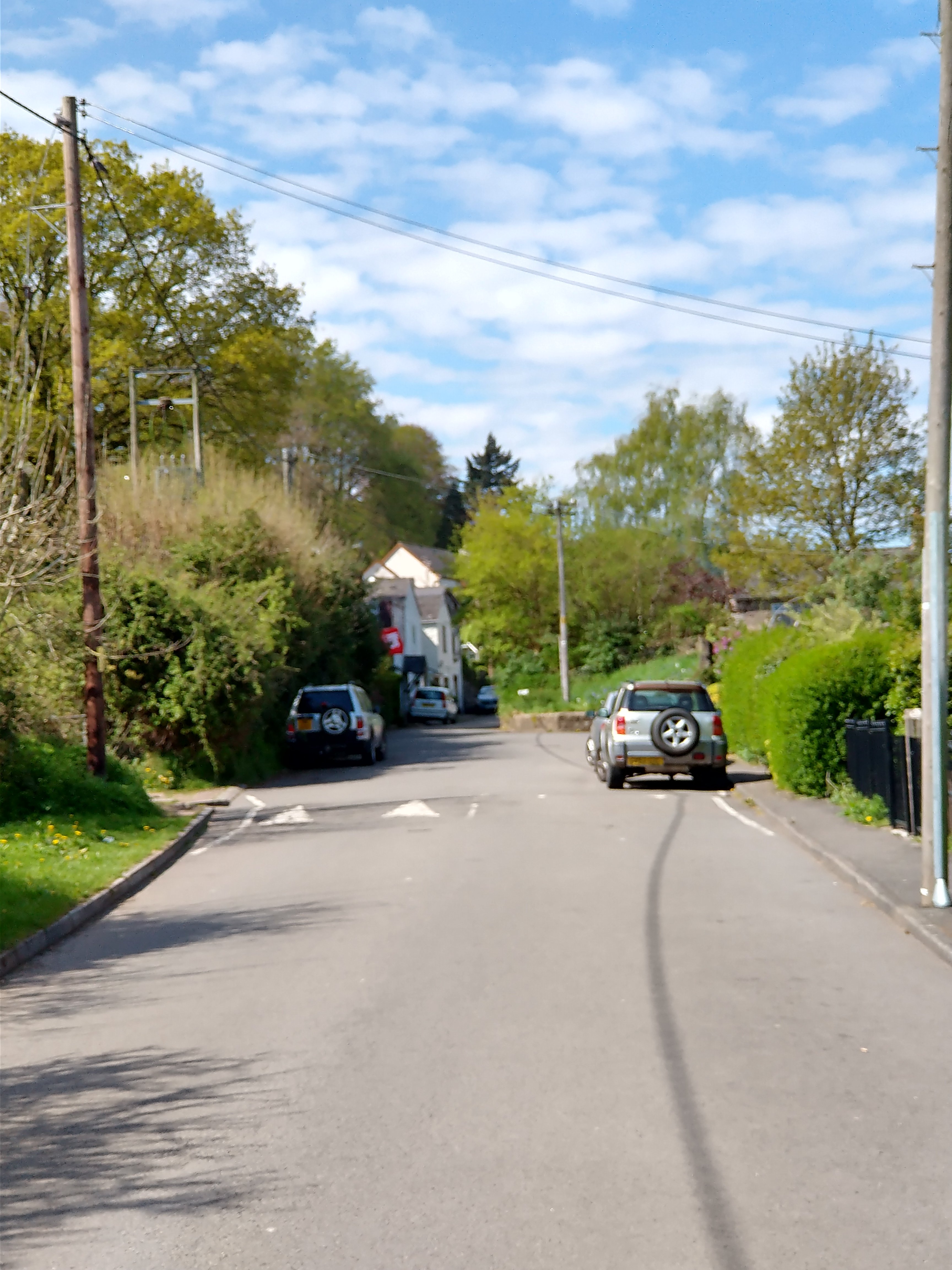
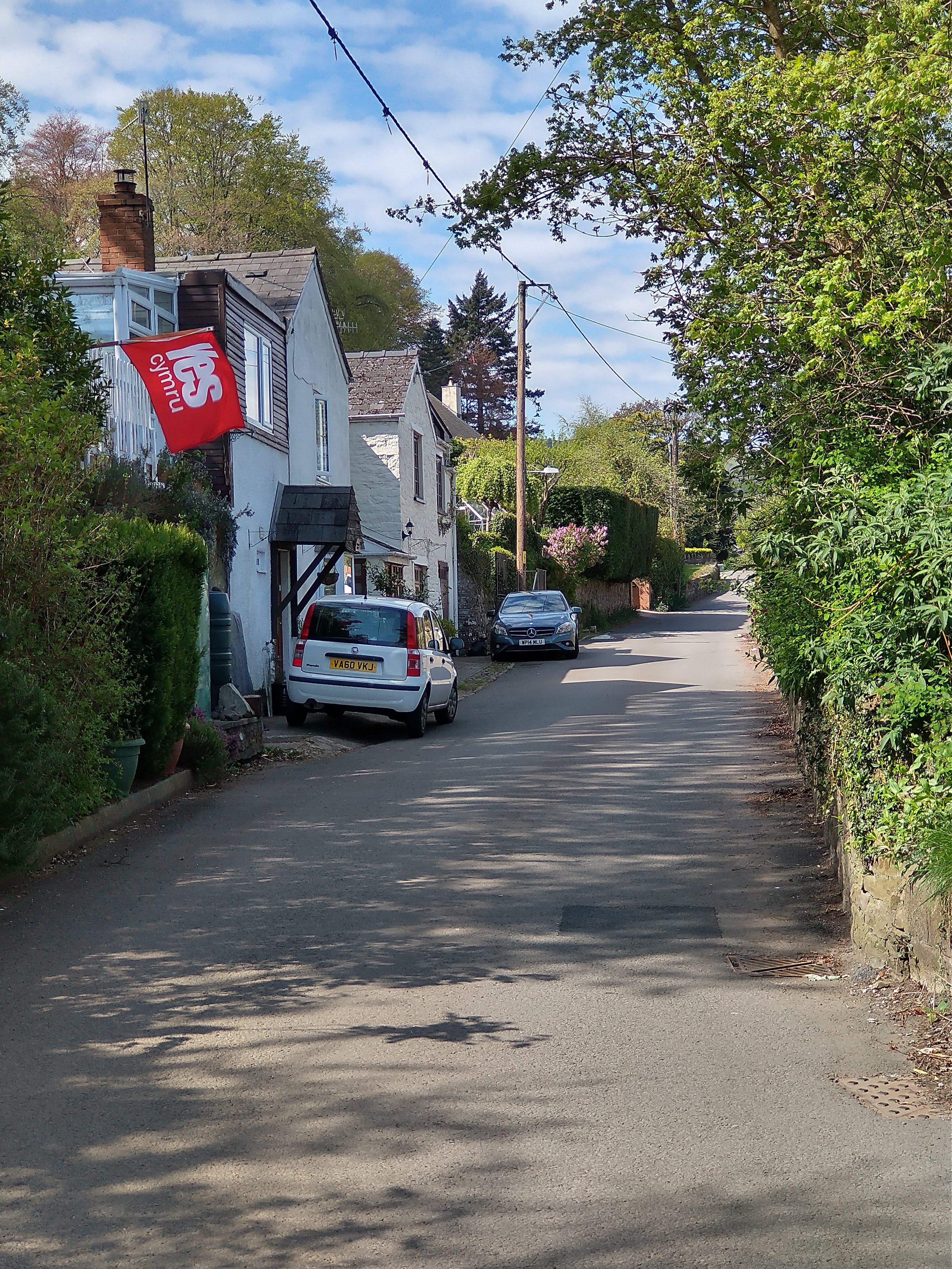
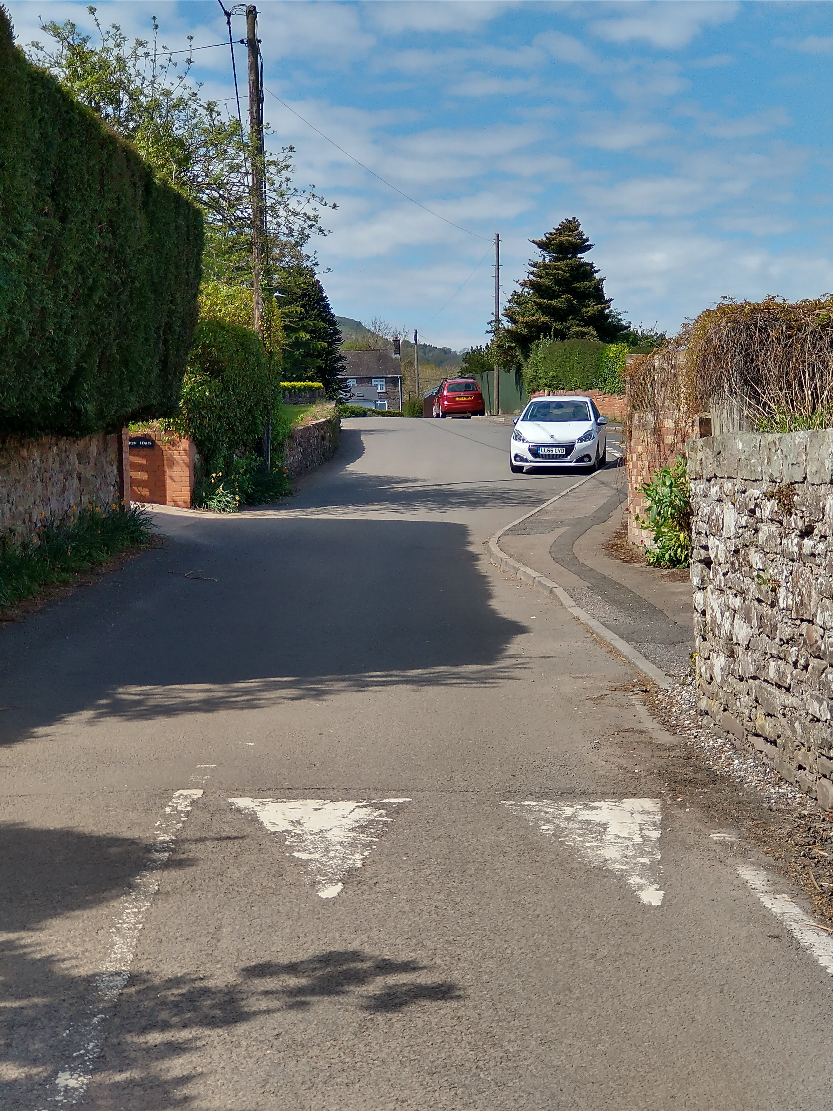
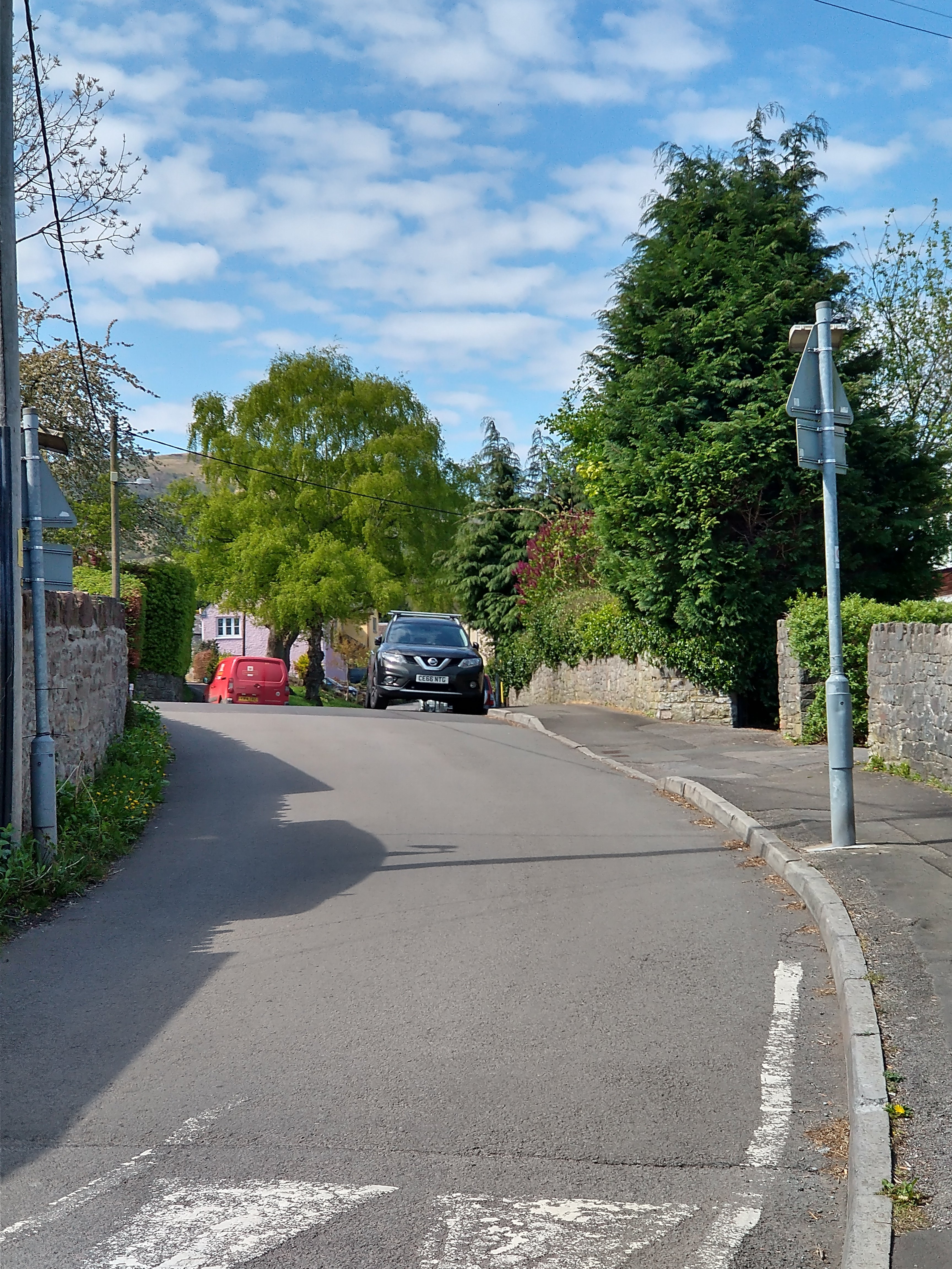
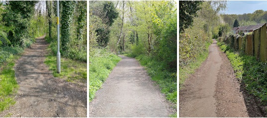
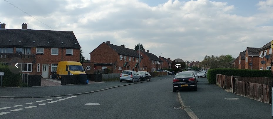
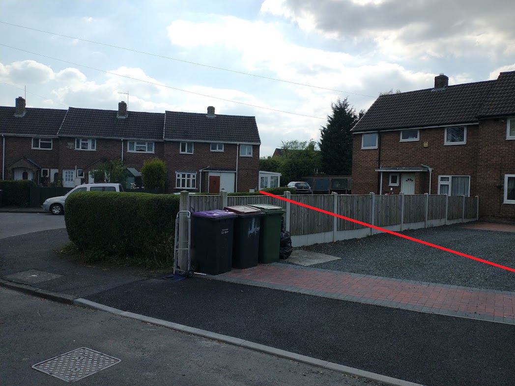
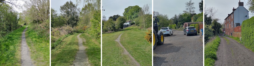
A sequence of photographs follows, taken on 25th April and showing the Tramroad route along School Lane, Govilon. ….
This last shot in the sequence taken along School Lane shows the route of the Tramroad further to the West. The Tramroad continued along the line of the narrow lane to the left of this photograph. (My pictures, 25th April 2022)
I hope to be able to follow further lengths of the Tramroad in future visits to Abergavenny.
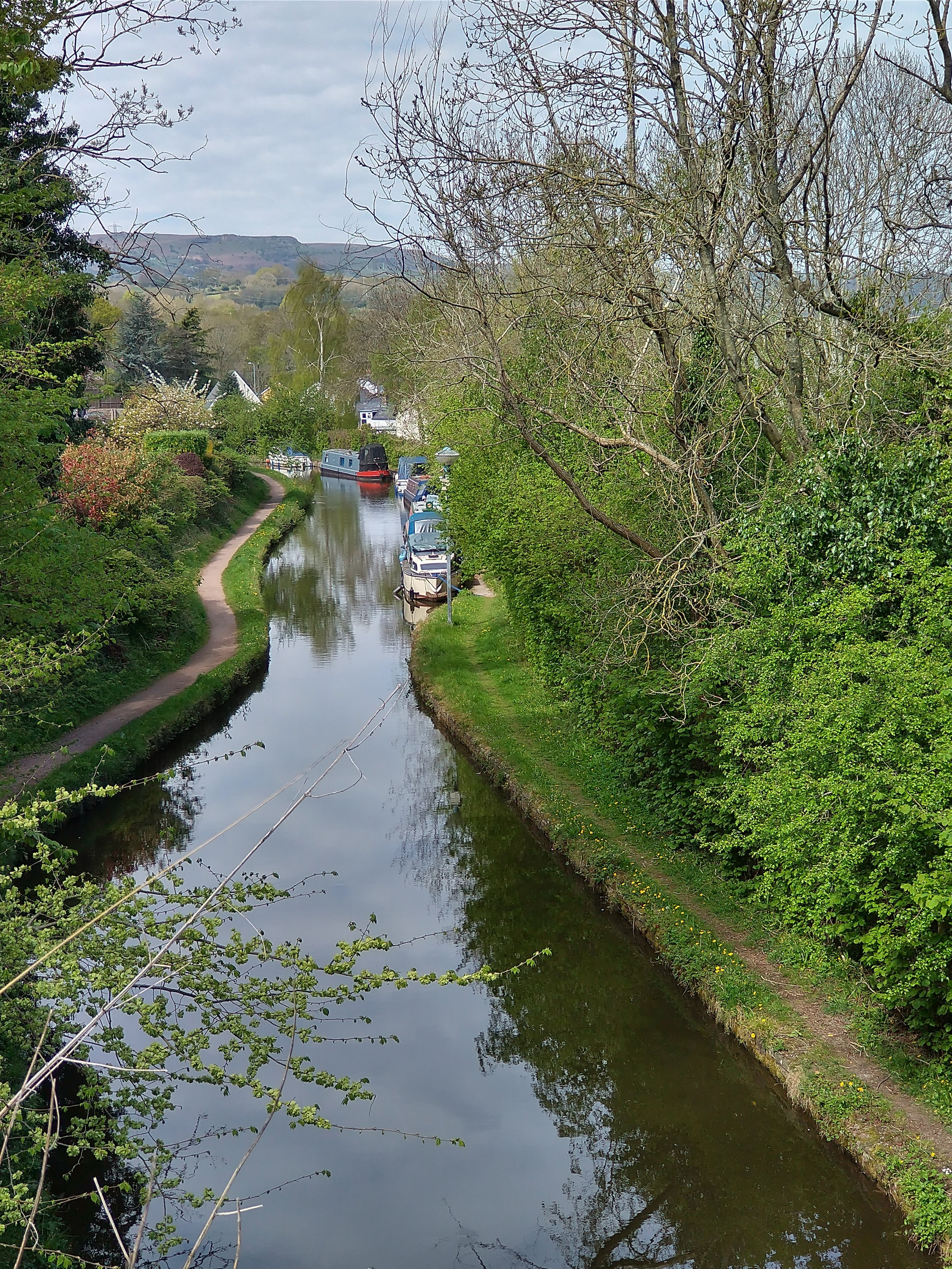
The Monmouthshire and Brecon Canal
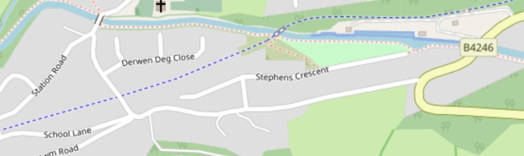
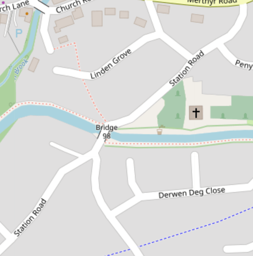
To complete this perambulation in Govilon, I visited the Canal bridge on Station Road in Govilon – Bridge 96 on the OpenStreetMap extract below. …
Two pictures at Bridge 96 on the Monmouth and Brecon Canal. (My photograph, 25th April 2022)
“The Monmouthshire and Brecon Canal is a small network of canals … For most of its currently (2018) navigable 35-mile (56 km) length it runs through the Brecon Beacon National Park, and its present rural character and tranquillity belies its original purpose as an industrial corridor for coal and iron, which were brought to the canal by a network of tramways and/or railroads, many of which were built and owned by the canal company.” [21]
To conclude …
Govilon provides a relatively unique interchange between canal, tramroad and railway with the routes of each running parallel to each other to the West of the village. Each route would provide a pleasant walk. The village of Govilon brings all three together in what is a very easy and accessible amble.
W.W. Tasker; The Merthyr, Tredegar & Abergavenny Railway and branches; Oxford Publishing Co., Poole, 1986.
Christopher Awdry; Encyclopaedia of British Railway Companies; Patrick Stephens Ltd., Sparkford, 1990.
Mike Hall; Lost Railways of South Wales; Countryside Books, Newbury, 2009.
Michael Quick; Railway passenger stations in Great Britain: a chronology (4th ed.); Railway & Canal Historical Society, Oxford, 2009.
R.V.J. Butt; The Directory of Railway Stations: details every public and private passenger station, halt, platform and stopping place, past and present (1st ed.); Patrick Stephens Ltd., Sparkford, 1995.
M.C. Reed; The London & North Western Railway; Atlantic Transport, Penryn, 1996.
David Edge, David (September 2002). Abergavenny to Merthyr including the Ebbw Vale Branch. Country Railway Routes; Middleton Press., Midhurst, 2002.
C.R. Clinker; Clinker’s Register of Closed Passenger Stations and Goods Depots in England, Scotland and Wales 1830–1980 (2nd ed.); Avon-Anglia Publications & Services, Bristol, 1988.
James Page; Rails in the Valleys. London: Guild Publishing, London, 1989.
UK Retail Price Index inflation figures are based on data from Clark, Gregory (2017). “The Annual RPI and Average Earnings for Britain, 1209 to Present (New Series)”. Measuring Worth, accessed on 2nd December 2021.
Helen J Simpson; The Day the Trains Came: the Herefordshire Railways; Gracewing Publishing, Leominster, 1997.
John Bartlett’s father, Cyril, was Station Master in the period before the closure of Govilon Railway Station. This picture was shared by John Bartlett on the Facebook group ‘Govilon and Gilwern Past’, accessed on 26th April 2022.
I came across a first reference to a Tramroad in Coalbrookdale in a book by Barrie Trinder published in association with the Ironbridge Gorge Museum Trust in 1977. Trinder collated a series of references to Ironbridge and Coalbrookdale from ancient texts in his book entitled “The Most Extraordinary District in the World.” [1]
Trinder provides an extract from a book written in German by C. von Oeynhausen and H. von Dechen entitled “Railways in England 1826 and 1827” translated by E.A. Forward. [2] in which Oeynhausen and Dechen comment that, “In Coalbrookdale, a cast iron Tramroad runs from the Severn to the lower smelting works of the Dale Company.” [1: p94, 2: p67]
They noted that the Tramroad was a Plateway with rails between 5 and 5ft 6in. in length tied together by cast iron sleepers. Of great interest is their note that, “The tramroads at Coalbrookdale are of two sizes. The smaller one is of 20in. gauge, and the haulage in this is performed with small trucks; it lies in the middle of a larger line of 36in. gauge. Horse haulage is used thereon. It perhaps merits remark that the smallest gauge for horse use employed anywhere is to be found in this district, as on some lines the gauge is only 18 inches …” [1: p94, 2: p67]
The authors go on to note that at Horsehay Ironworks, part of the Dale Company’s holding, there were “tipping wagons with sheet iron bodies on wooden frames, very suitable for the transport of blast furnace slag. The wheels on these wagons [were] from 14 to 18in. diameter, and [had] wider wheel rims than … employed elsewhere in England, and especially in South Wales, namely [1.25 to 1.5]in.” [1: p94,96, 2: p67]
They recorded that the plateway was laid with the vertical flange on the inner side.
Plate 47 in Trinder’s book provides a photograph of a dual-gauge plateway which was uncovered adjacent to Rose Cottage, Coalbrookdale in 1971. [1: p95]
Other references to the Tramroad include its inclusion in the Historic England register; the History Workshop Online.
Historic England Monument No. 72035 Grid Reference: SJ6682404251
Summary: Iron tramroad 1767 (course of)
More information: The first iron tramroad existed at the Coalbrookdale Works.
The Tramroad within the Coalbrookdale works is recorded by Historic England as the first ever iron tramroad. Their record states:
“It being found that the wooden rails of the tramroad of one mile length, laid in 1757, along which coal and iron were conveyed from one part of the works to another as well as to the landing places along the river Severn, soon became decayed or broken, after experiments, the rails were replaced in 1767 by rails of cast iron.” [3]
“A specimen length of rail and a wagon are preserved within the open-air museum at the Coalbrookdale Works at SJ 66780485. The tramroad terminus together with the quay and offices are at present being restored on the N bank of the river Severn, at SJ 66780363, by the Ironbridge Gorge Museum Trust.” [3]
“A paving of mortared bricks, with grooves which formerly held planking to which the iron rails were attached, has been uncovered and renovated. The quay, of large stone blocks, has been cleared of silt and the dock offices and a tram shed, housed in a castellated ‘Gothick’ style building of red and yellow brick, are undergoing restoration at the present time.” [3]
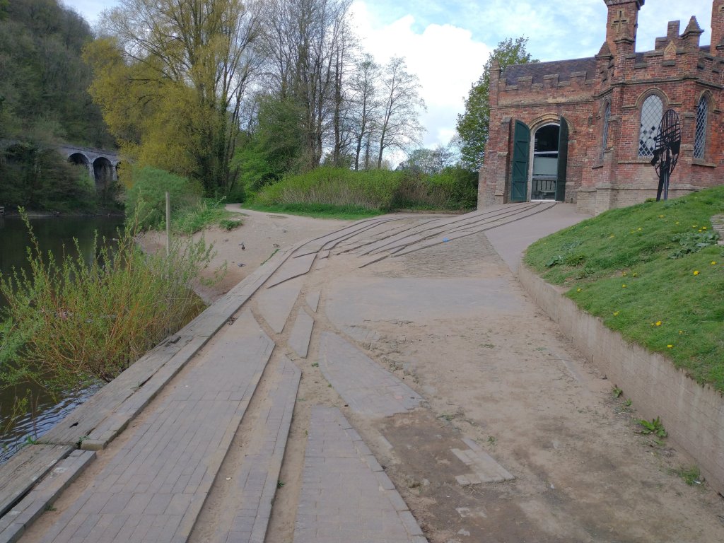
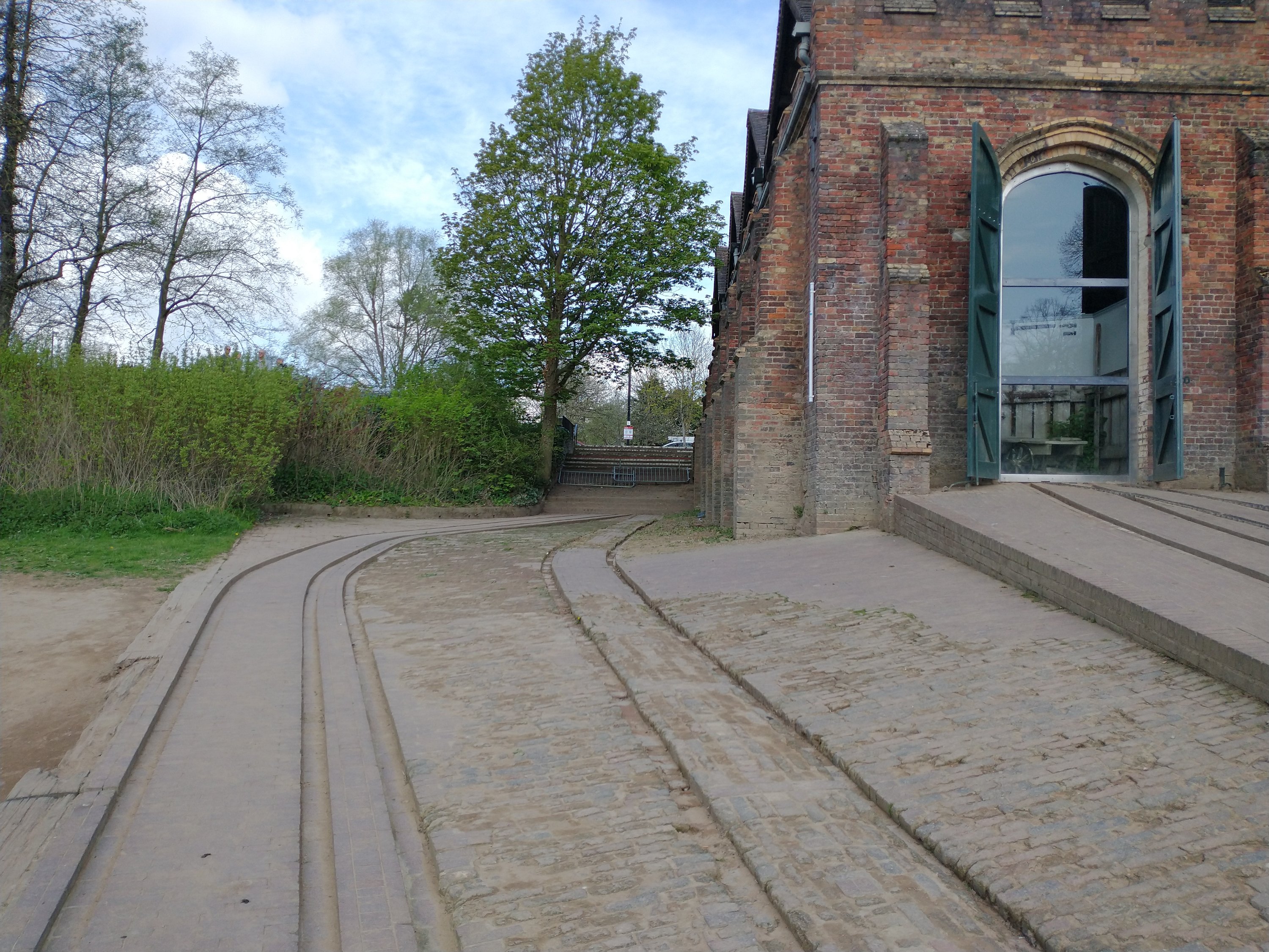
These notes are a little out of date now. Much of the work referred to has been completed. A visitor centre is accommodated in the tramroad goods shed on the Wharf and some of the tramroad sidings at the Wharf have been renovated. The pictures below give an impression of what the Wharf area is like in 2022. …
Coalbrookdale Wharf in April 2022. (My photograph)Tramway tracks alongside the Goods Shed at Coalbrookdale Wharf. (My photograph)The Goods Shed on the wharf at Coalbrookdale. (My photograph)
History Workshop Online (HWO)
HWO comments as follows: “In 1757 Richard Reynolds, son-in-law of Abraham Darby II, took over managing the Coalbrookdale Works and, in 1767, introduced metal rails for transporting coal and iron around the works and down to the river, as wooden rails were easily damaged and costly to repair. This was the first time metal rails had been used anywhere, inspiring tramways to follow suite, and the original metal tram rails can still be seen at the Wharfage in Ironbridge.” [4]
From a short length of Tramroad linking the Coalbrookdale works to the River Severn a larger network of tramroads developed. It is important not to confuse this network centred on Coalbrookdale with the Lilleshall Company’s network which met the Severn at Sutton Wharf, East of Coalport. The Lilleshall plateway was very short-lived. It was operational by 1799 and closed in favour of the use of the Canals in 1815/16. [5: p35] That network is covered in Part 3 of this short series of articles.
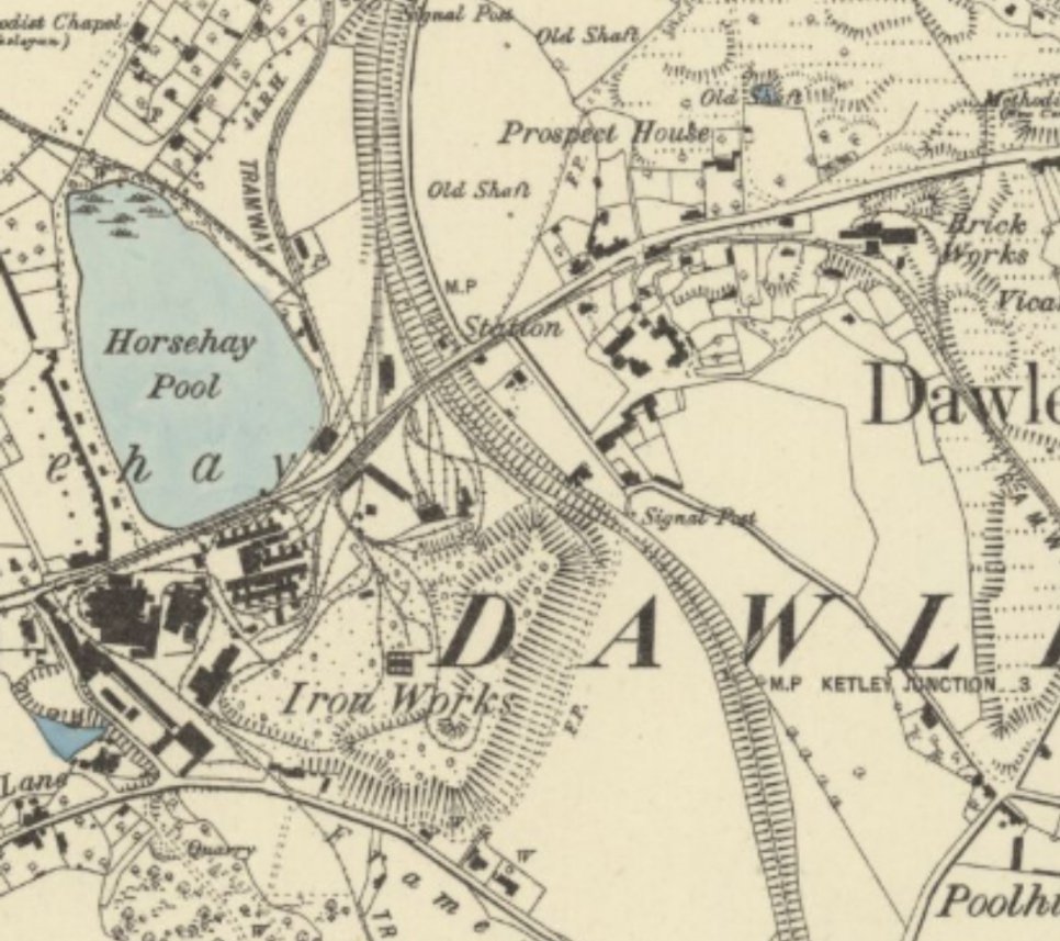
The tramroad in Coalbrookdale met the River Severn at the the bottom of the valley.
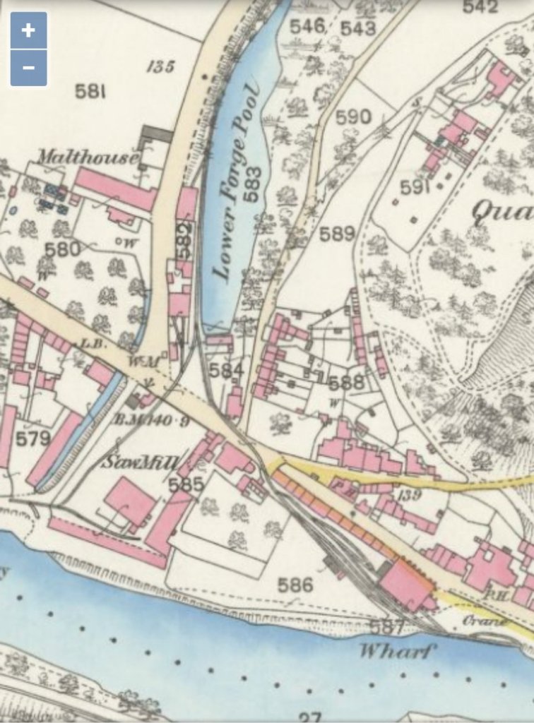
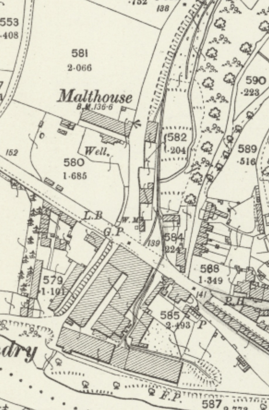
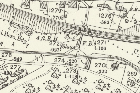
An extract from the 25′ OS Map series of 1883 is shown below. The tramroad wharf appears still to be in use at that time. A transhipment/goods shed is shown on the land just above the River Severn. A sawmill is shown at the bottom of Coalbrookdale below Lower Forge Pool. Interestingly, the Tramroad is shown crossing the road at two locations the line to the wharf was at a very shallow angle.
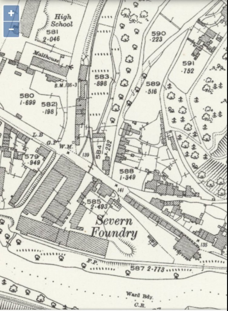
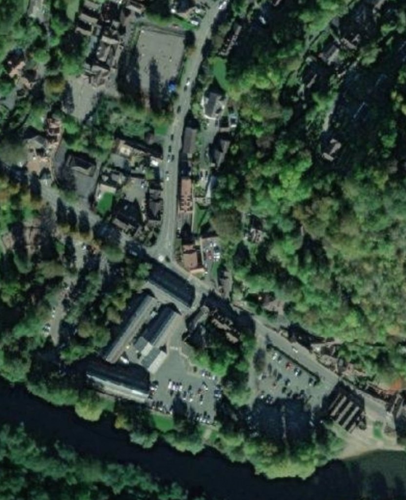
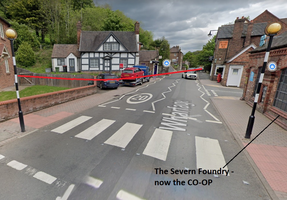
The extract from the 25″ OS Map series dated 1902 is shown below. At this time there was a foundry at the water’s edge and the tramroad terminated on a high level above the river. The goods shed shown on the map extract above still exists but is just off the view to the east. The sawmill above has been replaced by the Severn Foundry.
The extract from the 25″ OS Map series dated 1927 no longer shows the tramroad within the site of the Severn Foundry, although it still seems to be present within the road surface!
The NLS provides the 25″ OS Maps as an overlay to satellites images from the 21st century. The same area is shown below in an extract from those images. As can be seen the large warehouse to the bottom left of the above extract remains and is in use as the Museum of the Gorge.
Wikipedia notes: “The Museum of the Gorge, originally the Severn Warehouse, is one of the ten museums of the Ironbridge Gorge Museum Trust. It portrays the history of the Ironbridge Gorge and the surrounding area of Coalbrookdale, Shropshire, England.”
The Foundry complex also remains, although somewhat altered, and is in part a CO-OP supermarket.
The mouth of Coalbrookdale and the Wharfage in the first quarter of the 21st century.Looking Southeast along the Wharfage from a point just outside the old Severn Foundry. The red line approximates to the route of the tramway down to the wharfs on the River Severn.
A little further north from the Severn, north of the Lower Forge Pool, the Tramroad can be made out running parallel to the GWR Coalbrookdale branch but in the valley floor between the road and the stream. The GWR station can be see in the top left of the extract which is from the 1883 25″ OS Map.
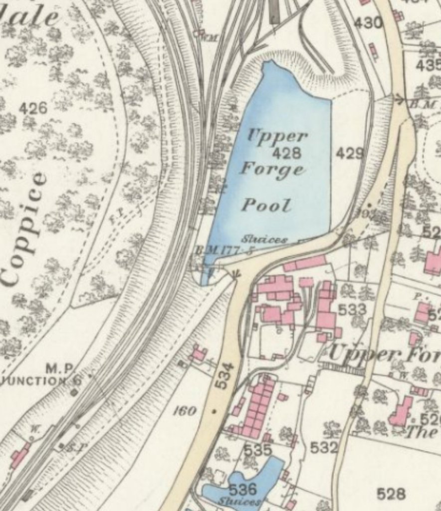
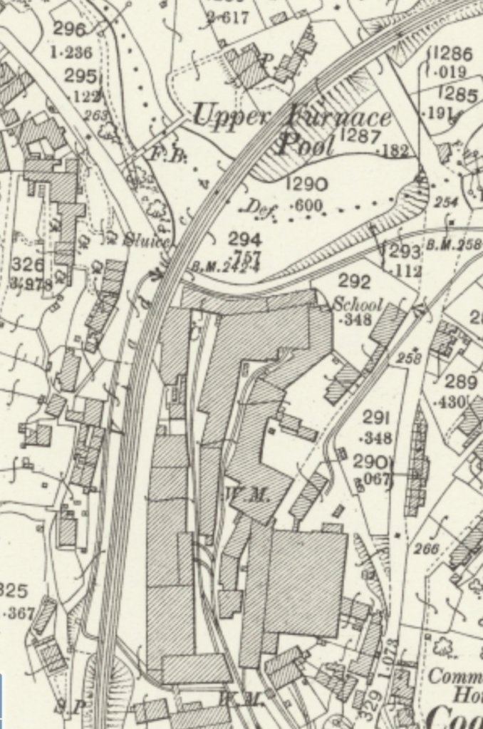
Further North the tramway/tramroad continues to follow the road verge, as below, until it crosses leaves the road adjacent to Upper Forge Pool. …
Standard gauge sidings began to dominate the area immediately around the next length of the tramway/tramroad route as can be seen below. The standard gauge tracks originate from the GWR line adjacent to the Upper Forge Pool and are at a higher level than the tramroad. The tramroad mainline ran north-northeast on the west side of the public road. A branch entered the Iron Works site before giving access to the raised area north of the Pool and also under the standard gauge line to the works buildings.
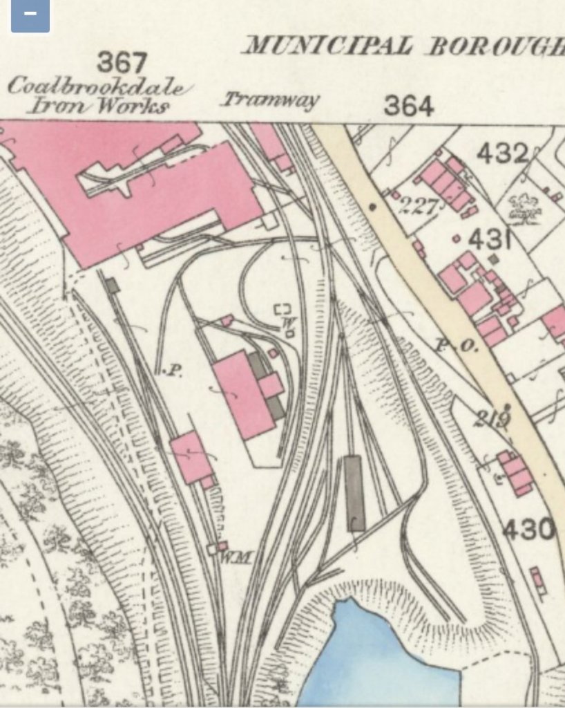
Sadly, north of the top of the extract below the 1st Edition OS 25″ series is not available on the NLS site.
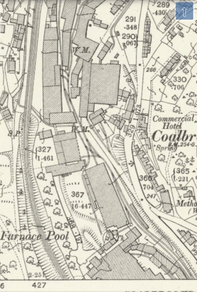
There was a significant network of tramroad tracks within the curtilage of the Coalbrookdale Iron Works. The site was constrained by the narrow valley and was, at its southern end, predominantly sited between the public road and the GWR line. Various sidings served the works in the valley floor, but the main line of the tramway passed under the GWR line at about the same northing as the Commercial Hotel to the east of the road.
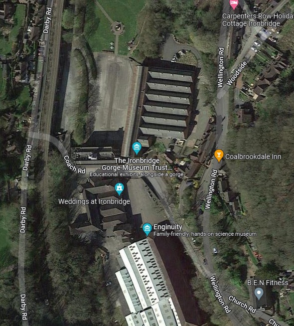
These two images show the buildings on the north side of Coach Road. Tramroad tracks used to run through the gates visible in the lower of the two pictures. The mainline turned to the left along Coach Road. Other tracks ran across Coach Road and between the two buildings opposite the gates. (My photographs)
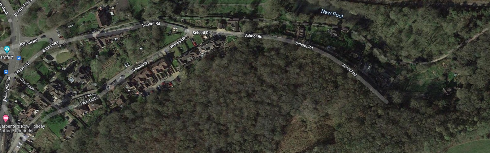
The Tramroad mainline left the gates in the photograph above and passed under the GWR line on what is now named Coach Road. The tramway/tramroad then ran immediately adjacent to that railway line on its West side, along the present Darby Road, for a short distance before crossing back under the GWR line adjacent to the Upper Furnace Pool and then following the South side of Darby Road, crossing the School Road, Wellington Road, Jiggers Lane, Darby Road junction on the level and then heading East along School Road.
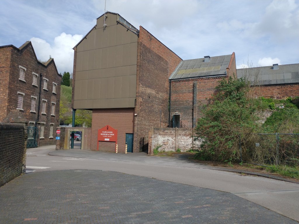
The Coalbrookdale Company’s Ironworks buildings have been given a significant new lease of life by the Ironbridge Gorge Museum Trust. The building to the South of Coach Road is now ‘Enginuity’ and that to the North of Coach Road is the ‘Coalbrookdale Museum of Iron’. ……
The Coalbrookdale Iron Works in the first quarter of the 21st century. (Google Earth)
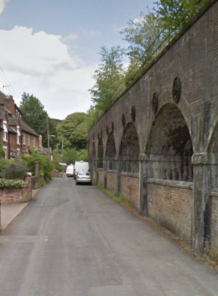
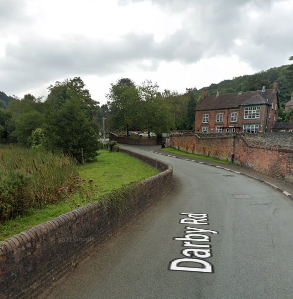
The route of the old tramway appears in the pictures below: first Coach Road, under the railway viaduct; then looking North on Darby Road; and then East along Darby Road from under the railway bridge next to Upper Furnace Pool. …
Coach Road looking West under the GWR Viaduct. The tramway ran under the bridge and turned sharply to the right onto Darby Road (Google Streetview)Darby Road looking North. (Google Streetview)Looking East on Darby Road. The Upper Furnace Pool is marked by the reedbeds to the left of the photograph. The tramway continued across the road junction ahead and followed the route of School Road travelling East. (Google Streetview)
The tramroad/tramway continued East on School Road as shown on the 1901 25″ OS Map Extracts below. It then ran on its own formation parallel to the GWR branch-line. The three OS Map Extracts below show the tramway in place just after the turn of the century. Google Maps shows its route in 2022 as a green-dashed line as can be seen further below.
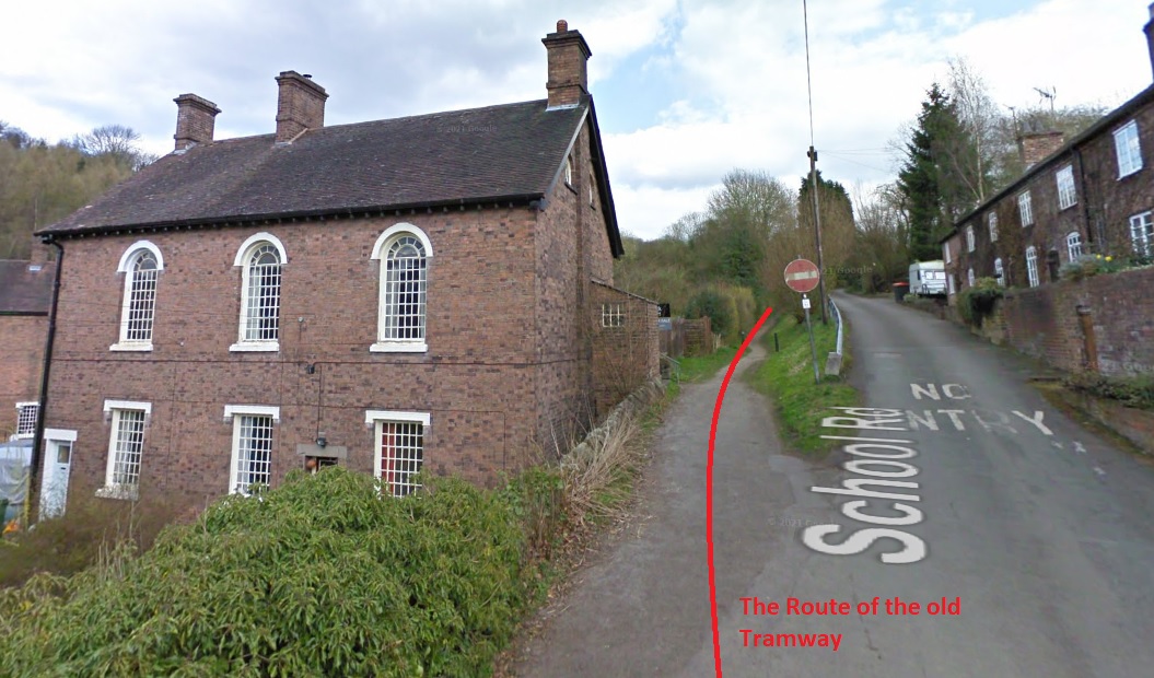
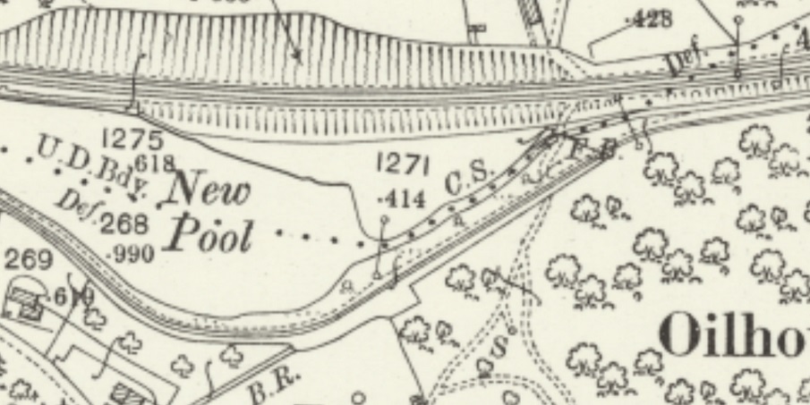
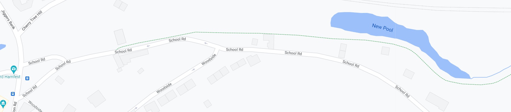
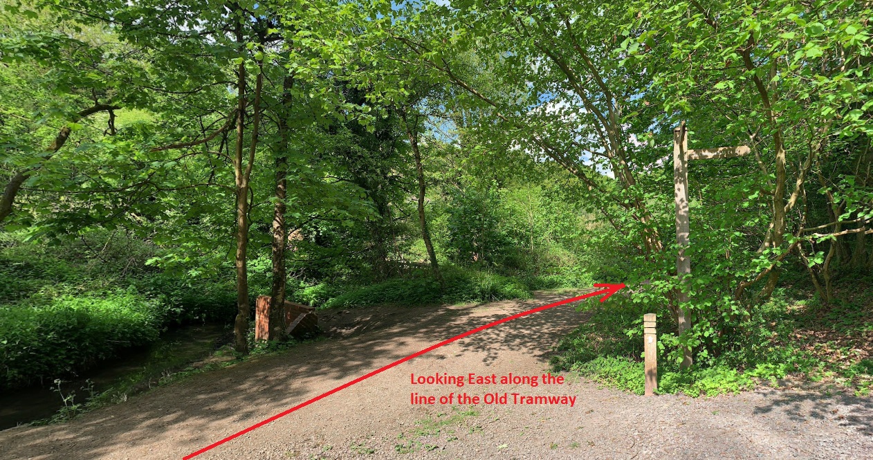
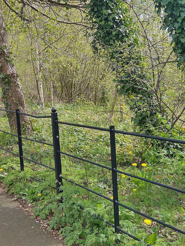
Google Streetview shows the tramway formation in use as a footpath. The building in the centre of the picture is the old school. (Google Streetview, 2011)Google Maps extract which shows the tramroad alignment as a green-dashed line, as over this length in the early 20th century, the tramroad formation is still in use as a footpath.The same area on satellite imagery from Google Earth. Google Maps helpfully shows the tramroad alignment as a faint dotted line. (Google Maps)Looking west along the route of the tramway from a point east of New Pool (c) Gordon Zola (Google Streetview, 2020)From the same point a view to the East. (c) Gordon Zola (Google Streetview)The formations of the railway and tramroad run parallel for a few hundred yards before the tramroad crossed under the railway.The modern public right of way remains on the South side of the railway embankment.
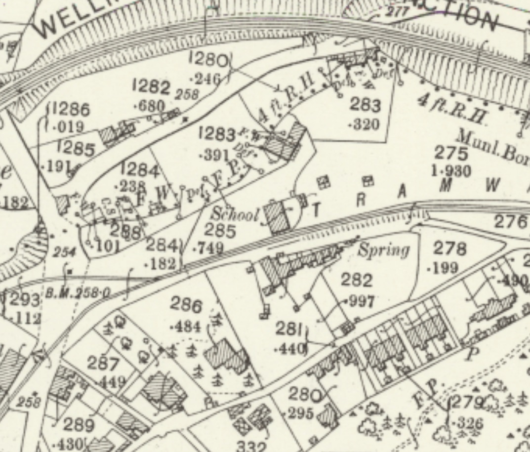
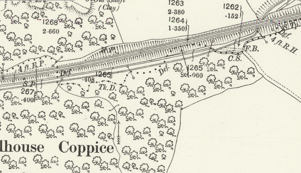
Immediately to the North of the railway line there were a series of Brick & Tile Works which were all served by the tramway. A significant network of lines were in place at the time of the surveying for the 1901 OS Map. The next image is of another extract from the OS mapping of 1901. The scale has been reduced to allow the whole immediate area on the north side of the railway to be seen at a glance.
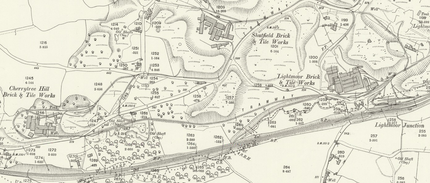
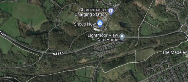
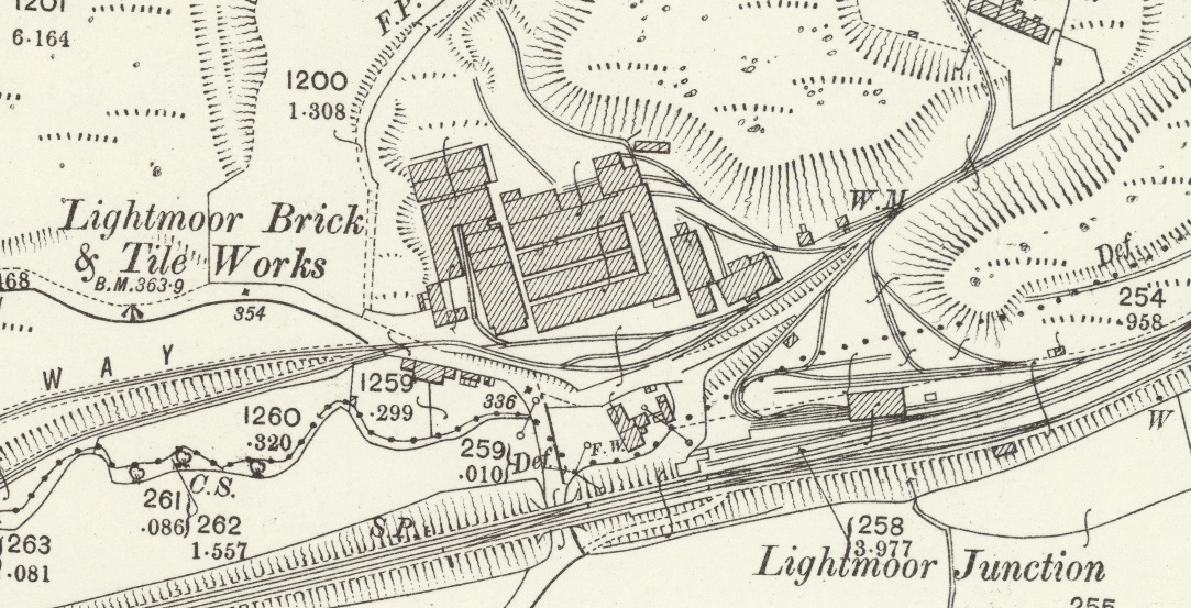
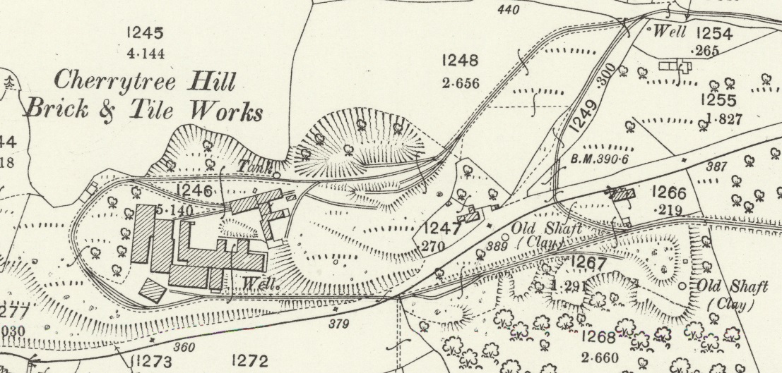
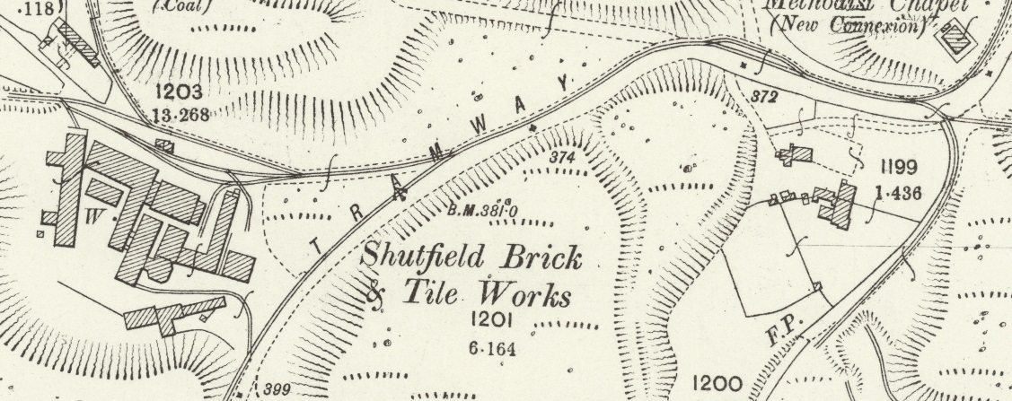
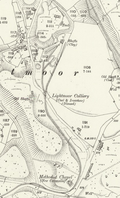
The tramway can be seen crossing under the GWR railway line at the bottom-centre of the extract. Lightmoor Brick & Tile Works were to the East of this point on the map and were encountered first. A trailing branch tramway ran back parallel to the railway line but this time on the north side of the line to provide access to Cherrytree Hill Brick & Tile Works. Just to the East of those works a loop line left east-west line of the tramway turning to the north. The east-west line ran just beyond the Cherrytree Hill Works before turning through 180 degrees and returning west-east. The two lines rejoined and continues eastwards to serve Shutfield Brick and Tile Works before then looping back to meet the original tramway mainline just to the east of the Lightmoor Brick & Tile Works.Google Earth shows approximately the same area in 2021. The A4169 now bisects the area which once was taken up by the different brick and tile works. The road curving in from the bottom left of this image is Cherrytree Hill. Cherrytree Hill Works were approximately in the grass area between the a4169 and Cherrytree Hill. A railway line still exists in this image on the alignment of the double track line on the OS map extract above. The location of the Lightmoor Brick and Tile Works is probably directly under the line of the A4169.
The next three map extracts focus on the three brick & tile works mentioned above.
The Lightmoor Brick & Tile Works. Note the complex arrangement of tramway/tramroad tracks and the transshipment facilities close to the Lightmoor Junction on the standard-gauge line!The Cherrytree Hill Brick & Tile Works. Note the two loops of the tramway, one each side of the Works.The Shutfield Brick and Tile Works. The tramway track leaving the map extract to the top-left was a short section which in 1901 led only a few yards further north. Two lines leave the map extract at the top-right. The lower of these was the link back to the mainline to the east of the Lightmoor Brick & Tile Works. The other led north, just to the east of a new Methodist Chapel, towards the Lightmoor Colliery.Lightmoor colliery – by 1901, the date of this map extract, the colliery was no longer in use.
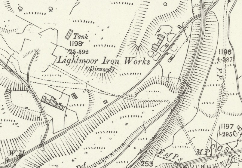
We return to the course of the old tramway mainline. Immediately east of the Lightmoor Brick and Tile Works was the site of the Lightmoor Iron Works which, by the turn of the 20th century, were disused and substantially demolished. After passing though the site of the Iron Works the tramway passed under the standard-gauge line once again.
The site of Lightmoor Iron Works with the tramway passing under the GWR line at the top-right of the map extract.
It is worth pausing at this point in our journey to find out a little more about the Works served by the tramway over the last half-mile or so. …….
Shutfield Brick & Tile Works
The information about the Shutfield site is distilled from the Discovering Shropshire’s History website. [6]
The Works at Shutfield have been given the Historic England Register No. 03871. The Works started out as a Brickworks and was producing bricks from, at least, 1825 until the late 19th century. It commenced making tiles in the mid-19th century and focussed on producing tiles from 1894 onwards. It continued to produce tiles until after the Second World War.
Two categories of tiles were produced, roofing tiles and floor tiles. These were branded with the “Lightmoor Broseley” stamp. The kiln at Shutfield Tileries was an intermittent down draught kiln with drying sheds. . . .Water leaking into the kiln from a stagnant mere less than 15 metres to the west was enough to mean its inevitable closure in 1951.
Cherrytree Brick & Tile Works
The information about the Cherrytree site is distilled from the Discovering Shropshire’s History website. [7]
The Cherry Tree Hill brick and tile works was first recorded in 1761. It closed in the early 20th century. The Works have been given the Historic England Register No. 03872.
The works were the first industry in Lightmoor producing clay products. The produce of the works was basic wares for basic uses. Perforated flooring squares, quarry tiles and roofing tiles were produced on a small scale for general industrial and local use. Bricks and firebricks were also produced both pressed in later times and handmade in the earlier phase of the work’s existence. Originally called Cherry Tree Hill Brickworks, it must have expanded into tile production between 1840 and 1880, when it was titled Cherry Tree Brick and Tile Works. No trace of the kilns in use at the works have survived, although a down-draught intermittent kiln is likely.
Lightmoor Brick & Tile Works
The information about the Lightmoor Brick & Tile Works is distilled from the Discovering Shropshire’s History website. [8]
Lightmoor Brickworks was first mentioned in 1779, when it was owned by John Davies. . . .Its initial base of production was bricks, made by the semi-dry process. This was followed by other basic wares of the early 19th century including flooring bricks, draining pipes, chimney pots, and lightweight roofing tiles.
During the 1860s the diversity of products began to escalate. The next decade heralded a phase of moulded decorative terracotta. . . Which continued until the turn of the century, and the works turned back to brick manufactures. From the 1900s to the closure of the Coalbrookdale Co in 1933, Lightmoor Brickworks supplied them with all the firebrick shapes for their solid fuel appliances. In the fifty years from 1933 to the late 1980s Lightmoor continued to survive on brick manufacture.
Lightmoor Iron Works
The information about the Lightmoor Iron Works is distilled from the Discovering Shropshire’s History website. [9]
Little is known about the the Iron Works, but there were a number of structures (which appear on the 1901 Ordnance Survey extract above) to the east of the location of the furnaces. These were thought to initially be part of the industrial complex of the ironworks, later converted to domestic use.
In 1984 the Ironbridge Gorge Museum Archaeology Unit excavated parts of the Lightmoor Ironworks site in advance of its destruction by the Ironbridge By Pass. Trenches were dug to examine the wall footings of that group of buildings to the east of the furnaces. These buildings had been constructed directly onto coarse pit waste, and stood until recently. The area was badly disturbed after their destruction, which obliterated all traces of floor levels. Nothing was found which would have enabled the different usages thought to have applied to be confirmed.
Lightmoor Colliery
Lightmoor Colliery appears on the Hudson Institute of Mineralogy Mindat.org register as owned by the Coalbrookdale Company and as being active between 1855 and 1885. [10] It should, incidentally, not be confused with the colliery of the same name in the Forest of Dean!
And now continuing to follow the tramway mainline ….
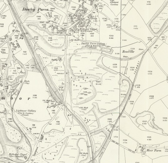
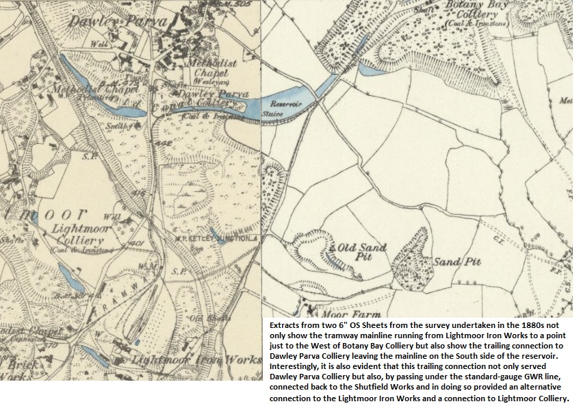
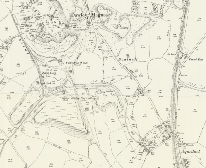
Two further extracts from the 1901 25″ OS Mapping follow. The first shows the tramway providing access to Dawley Parva North of the point where the tramway crossed beneath the standard-gauge line the map extract below shows that the tramway passed to the east of Dawley Parva Colliery. A tailing connection to the tramroad had already been lifted by the time of the survey for this Map series. The colliery was redundant but I was unable to locate any information about it on line. However, the 1880s 6″ series of OS Maps did provide more information.
Two OS Maps – the first is the 25″ series from the turn of the 20th century. The second is the 6″ series from the 1880s.
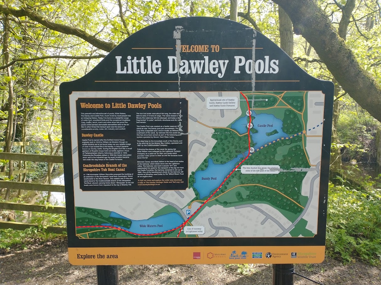
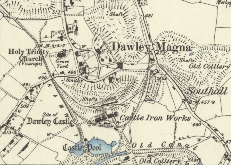
The remaining length of the Tramway on the 1901 Maps is shown immediately below. It originally would have served Dawley Castle Iron Works and provided for transshipment to the canal arm which extended from the Shropshire Canal at the village of Aqueduct passed Botany Bay Colliery to serve the Castle Iron Works.
These short notes, in italics, about the Shropshire Canal are distilled from the Aqueduct village website. [11]
The canal was built following an act of Parliament of 1788, its function being to link the ironworks and mines in the Oakengates area to the River Severn. The waterway was opened in 1792. It ran southwards from Wrockwardine Wood, via Oakengates, through a tunnel at Stirchley and on to Southall Bank whereupon it split into two branches. The western branch was intended to meet the river at Coalbrookdale but was never built beyond Brierly Hill; it was this branch that crossed the aqueduct.
The eastern branch went via a descending inclined plane of 126 feet at Windmill Farm to the wharf at Tweedale and then on through Madeley to meet the river, using the Hay Inclined Plane and a short canal at Coalport.
Of interest to me, is the point at which in 1901 the Tramway finished, alongside Holy Trinity Church, Dawley. This is one of the churches in the Central Telford Parish. As I write this article in April 2022, my wife is Rector of the parish.
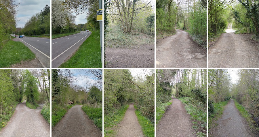
I walked the length of the tramroad from the modern A4169 close to what were Lightmoor Iron Works and the point at which the tramway passed under the GWR standard-gauge line North to Pool Hill on 21st April 2022. I as able to combine this with a walk along part of the GWR standard-gauge route and the tramroad which served Dawley Parva.
First, the mainline from Lightmoor Iron Works to Dawley Castle. ….
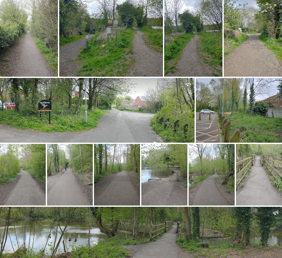
This first series of photos show: the view east along the A4169; the view West along the A4169; the view along the alignment of the GWR standard-gauge line at the point where the old tramway crossed under it (there is no bridge at this location in the 21st century; a sequence of seven views as I walked North along the old tramway. (My pictures)The first of this next block of photos is the last view of the mainline before reaching the place where the trailing connection serving Dawley Parva met the mainline. The second photograph shows the two lines at their point of meeting, in this image the camera has been turned through 180 degrees, the left-hand path follows the mainline, the right-hand is the route of the line serving Dawley Parva. The first panorama is taken from the North on the access road to the carpark. The two lines meet just off to the right of the picture and the tramroad route then travels across this image from right to left just on the near side of the modern house visible towards the right of the image. The image adjacent to the panorama is taken close to the line of the tramway looking towards Dawley Castle. The ivy cover tree trunks sit over the line of the tramroad. The next sequence of 6 pictures continue to follow the tramroad in a Northeasterly direction towards Castle Pools. This is, incidentally probably the line of the old canal mentioned in the text. The alignment of the old tramroad swings round to the North and crosses various water channels which link the Pools. The final panorama is taken looking back South along the old line. (My pictures)Just beyond Castle Pool is this noticeboard. The picture is taken facing South immediately to the North of Castle Pool. I have superimposed the tramway routes in red on the photograph. (My picture)The tramroad route continues North and then crosses Holly Road close to Holy Trinity Churchyard.The panorama of the churchyard shows the tramroad route running along its Western boundary (the left of this image). The adjacent two phots show the route of the tramroad. The second is taken at approximately the point at which the 25″ OS Mapping showed the rails terminating. The 6″ series from the 1880s shows the tramroad continuing directly ahead at this point through the estate which has been built over its line. (My pictures)
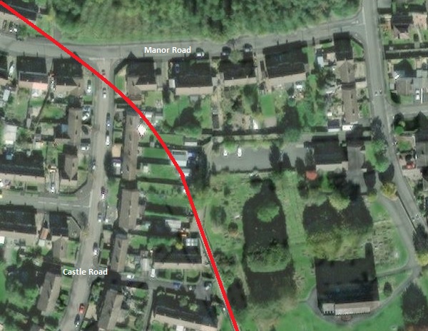
For the next half mile or so, the old tramway route has been built over by housing and amenities. Its approximate line can be plotted on modern satellite images as below.
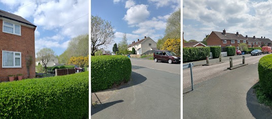
Satellite images provided by the National Library of Scotland can be overlaid with older map details which means that the red line shown on this satellite image is reasonably accurate. The pictures which follow endeavour to give a good impression of the alignment in the 21st century. (NLS Satellite image)These three photographs were taken on 21st April 2022 at the junction of Manor Road and Castle Road, Dawley. The third image looks back along the tramway alignment towards Holy Trinity Church. The church tower can be glimpsed next to the gable end of the house on Castle Road. The other two images look Northwest – the tramway route passed to the right of the house in the first image and then ran along Manor Road in front of the cream-coloured properties in the second image. (My photographs)
The 6″ OS Maps of 1888 show the Castle Iron Works in active use, as shown below. The canal arm was already disused by this date but the Tramway extends north beyond the church.
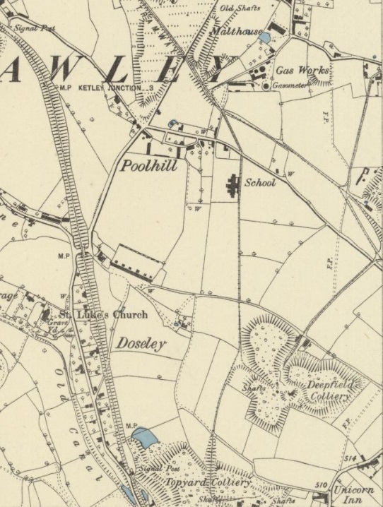
The next OS Sheet published in 1885 shows a significant network to the North of the church. The first map extract below shows the tramway entering from the right side of the map at a triangle of lines which provided access to Deepfield Colliery.
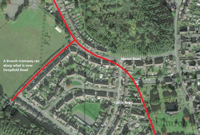
The tramway passed to the West of Holy Trinity Churchyard and then curved through what is now a housing estate. It alignment crosses Castle Road close to its junction with Manor Road before following Manor Road Northwest. A branch served Deepfield Colliery and followed the line of the modern Deepfield Road. (NLS Satellite imagery)
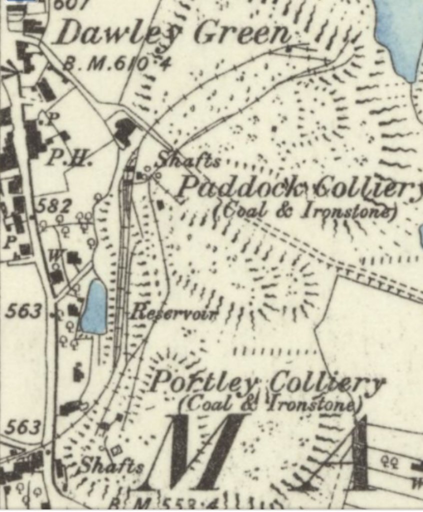
A very short distance beyond the line to Deepfield Colliery a branch heads north-northeast and then East towards two pits – Paddock Colliery and Portley Colliery – both are shown on the second map extract below. They were close to Dawley Green, and as a result relatively close to our Vicarage, just a few hundred yards further north!
The branch to the Portley and Paddock Collieries is lost under modern housing over the first couple of hundred metres.The first part of the branch tramway to Portley and Paddock Collieries. (NLS)The branch-line ran diagonally through the cream houses at the centre of this image. (My photograph)It passed behind the house with the yellow van and crossed the line of Webb Crescent and then trough the first property on the right with a gable-end facing the road. (My photograph)Springfield Close – the tramway followed the red line, passing through the end terrace. (My picture)The line continued towards Dawley along Springfield Close turning to the right approximately at the end of the yellow brick apartments. (My photo.)Looking back along the tramway route. (My picture)From the same location, looking towards the two collieries. The Telford Langley School and Sports Centre is now on the site of the two collieries. (My photograph)Take these three pictures in reverse order and they show the route of the tramway which follows one of the access routes to the school. (My photographs)These two photos get us as far as we can along the branch tramway route. (My pictures)
Returning to the main line, it continued Northwest. …
The old tramway route crosses the open school playing field towards the one easily identifiable property with the new roof. From there it crosses into a tight knit series of houses emerging on Upper PoolHill.
After passing through the modern housing, a trailing connection joined the tramway mainline, it served Topyard and Deepfield Collieries. This is highlighted on the satellite image below.
The tramway from Topyard Colliery enters from the bottom-centre of this satellite image, The mainline, from the bottom-right. (NLS)
On the 6″ OS Map extract below the tramway passes between the ‘E‘ and ‘Y‘ of ‘Dawley’. That straight length of tramway is the length now under the modern road, Upper Pool Hill. The map extract below
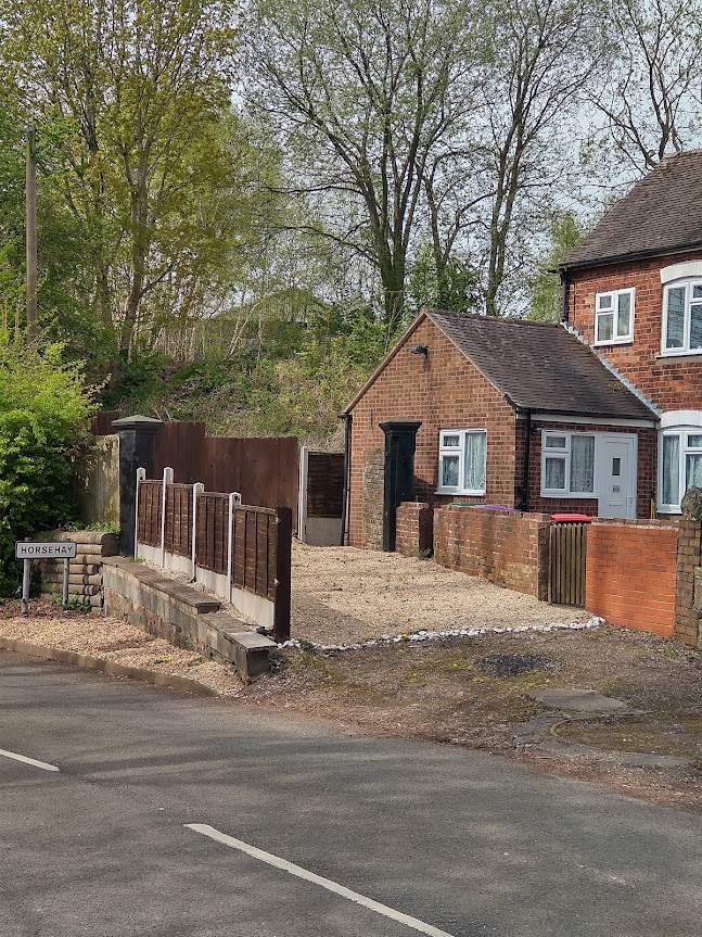
To the West of Dawley village the line split with one branch heading a short distance west on the South side of Prospect House and over the GWR line to get to the Horsehay Iron Works. Out of a significant complex of lines at the Iron Works, two further branch tramways served the Iron Works needs. One to the North, on the east side of Horsehay Pool, in the 1880s, allowed collieries on Horsehay Common to supply the Works. And one to the South led to a quarry at the head of Horsehay Dingle.
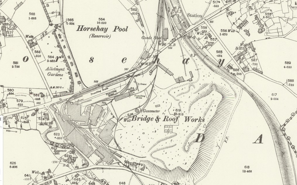
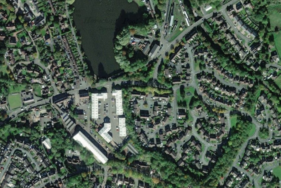
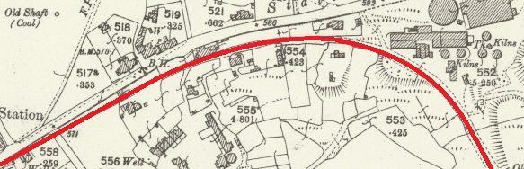
Horsehay as depicted on the 1885 6″ OS Map. Note the tramway entering the extract on the right splitting just south of the brick works and then running over the road bridge crossing the standard-gauge line and then entering the Iron Works site. Out of a cat’s cradle of lines on site, two tramways leave the site, one to the North and one to the South.This time the works at Horsehay are shown on the 25″ OS Map surveyed in 1901 and published in 1902. No tramways are now visible. The Iron Works is now a Bridge and Roof Works. Tracing the rails through the site back towards the standard-gauge line, it is evident that the works railways are now standard gauge. Many of the tight curves have been removed. No tramway now leaves the site towards Horsehay common to the North. Some evidence of the tramway which headed South can still be seen. There is no longer a tramway accessing the site over the railway bridge.The same areas in 2022. The area has seen a significant growth in private housing. Telford Steam Railway is now present top-centre of the image and the length of standard-gauge line is now a preservation line. Nonetheless features remain which enable some of the tramway locations to be established as the photos below show.
The pictures that follow were all taken as I walked the route on 20th April 2022 and were all taken from public roads. For convenience, I have marked the tramway route onto the 1902 survey map extracts below, and where modern road alignments are not obvious, I have added these. They cover the length of the tramway from Pool Hill to Horsehay.
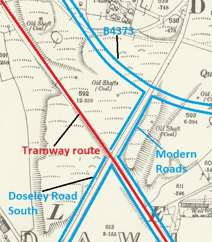
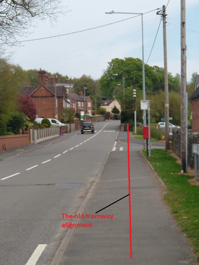
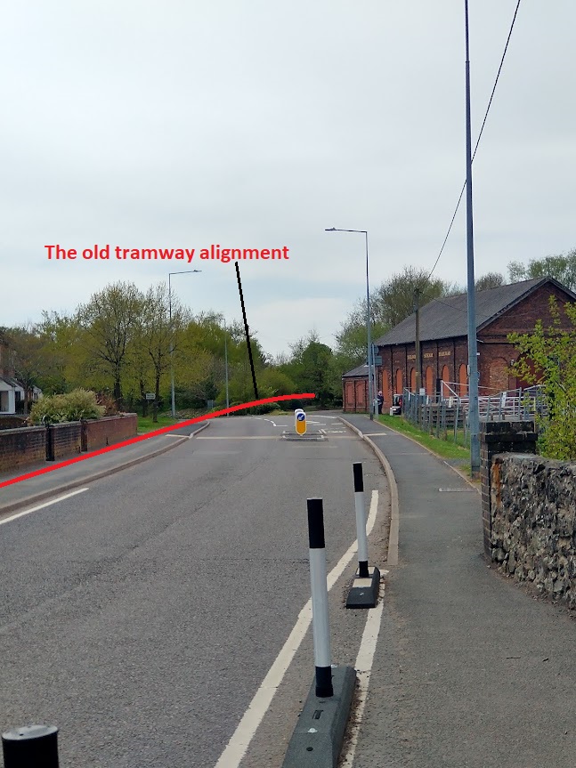
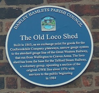
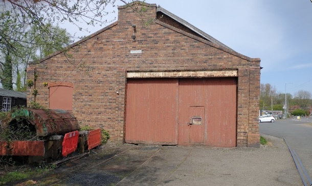
This first map equates to a portion of the right side of the 1885 map from around centre-right to about the top quarter point.This second extract is to a smaller scale as a result of its landscape layout. It shows the tramway turning through roughly 90 degrees to align with Station Road and then to cross the railway b ridge at the Station.Looking back Southeast along the line of the tramway from Doseley Road South along Upper Pool Hill in 2022. (My picture)Looking forward towards Horsehay along the line of the old tramway which is now a public footpath. (My photograph)In sequence, five views looking along the tramway formation towards Horsehay. The building in the last of these picture fronts onto Station Road with the tramway alignment running close to its rear elevation, (My pictures)Looking back from the North side of Station Road along the tramway route. The tramway climbed steeply to meet the highway and then ran along its South side until beyond the railway bridge.(My picture)Another view back along the tramway alignment, this time taken from the South side of Station Road at the railway bridge. (My photograph)Looking West from the north side of Station Road which at this point becomes Bridge Road. Note the railway building on the right which is part of the complex belonging to Telford Steam Railway. It is known as the Old Loco Shed and bears a blue plaque which explains its role in the 19th century. (My picture)The Old Loco Shed Plaque. Note its use as a transshipment point between the plateway (tramway) owned by the Coalbrookdale Company and the GWR standard-gauge line. (My photograph)The Southwest end of the Old Loco Shed. The tramway mainline passed to the right of this picture. (My photograph)Looking to the Southwest beyond the Shed. The main tramway route is shown by the red line. It passed to the back of the wall which can be seen in the centre of the image. The rails imbedded in the tarmac are remnants of the standard-gauge lines which served the Works at Horsehay once the tramway was replaced. (My picture)The tarmac pathway follows the line of the old tramway. (My photograph)Looking back to the Northeast towards the Old Loco Shed across the modern road. The pictures is taken from within what were the old Iron Works. (My photograph)Looking Southwest once again the old tramway mainline turned sharply into the Works at the location of the black gates. Along the last few hundred meters of the line a series of branch tramways fed off to the South into the Iron Works site.
We noted earlier in this article that two tramway branches left the Iron Works site, one to the North, on the east side of Horsehay Pool, at this time, allowed collieries on Horsehay Common to supply the Works. And one to the South led to a quarry at the head of Horsehay Dingle.
In covering these two tramway arms we cover the extent of the tramways on the 1882/83 survey. We do know that prior to this time waggonways/tramways ran further north through Lawley and Ketley and on to Donnington Wood. These lengths of the network are no longer shown on the 1882/83 OS 6″ Maps nor on the later 25″ Map series. A further article will hopefully be forthcoming covering the lengths of the Coalbrookdale tramways not addressed here.
The one to the North left to the East of the Old Loco shed shown above. Pictures of its route are shown below. …
The route to Horsehay Common ran from the East end of the Old Loco Shed which was at the time the transshipment facility giving access to the standard-gauge line of the GWR. The tramway branch ran roughly northwards. Its route is now a single track highway giving access to properties in Spring Village which is now part of a conservation area.(My pictures)
The second of the two branches passed through the Iron Works heading South and left the site at the location shown below. Just two photographs are shown as access onto the Works site was not possible and because, south of Woodhouse Lane, there is a new housing estate in Horsehay Dingle.
The old tramway brach left the Ironworks on the line of the concrete driveway illustrated here. The road in the foreground is Woodhouse Lane. (My photograph)Taken from Woodhouse Lane this picture shows the approximate alignment of the old tramway branch heading South the the quarry at the head of Horsehay Dingle.
Horsehay Iron Works …
I have seen two suggestions as to how Horsehay gained its name:
It was a staging post and feeding station for the pack horses pulling Ironstone from the canal at Ketley to the Coalbrookdale works. [12]
Its name is Anglo-Saxon for ‘an enclosure for horses’. [13]
Horsehay was nothing more than a farm, until the 1750s when Abraham Darby II built a blast furnace next to what is now known as Horsehay Pool. The entry on Wikipedia tells that, “The Coalbrookdale Company further developed the area, constructing brickworks and later a pottery in 1838. Coalbrookdale specialised in the smaller and more decorative ironwork pieces, whereas Horsehay produced many larger scale products, including the railway bridge in nearby Shifnal.” [13]
“The furnace at Horsehay came into blast successfully on 5 May 1755.” [13] However, it was not until 1857 that the standard-gauge railway arrived in the area and Horsehay got its own railway station. The Coalbrookdale Company built its own system of tramways/plateways which allowed them to transport goods to and from their main works close to the River Severn and to permit access to markets further afield.
More recently, “A.B. Cranes bought the site … occupied by the ironworks to manufacture some of the largest cranes in Europe until it closed down in 1983. The site has been transformed into both a small factory estate and a housing estate. The houses which were kept for the ironworks employees were clustered around Horsehay Pool in Spring Village, and they are still lived-in today.” [13]
Horsehay works has a history of more than 230 years on the same site!
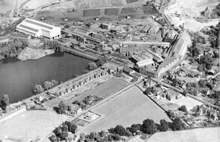
Horsehay Iron Works as pictured on Dawley Heritage’s website. The GWR standard-gauge line and sidings can be made out on the top left of the image. It is not possible to see any evidence of the tramways which once covered the whole site.(c) Iron Bridge Gorge Museum Trust (generous permission granted to include this image here) [14]
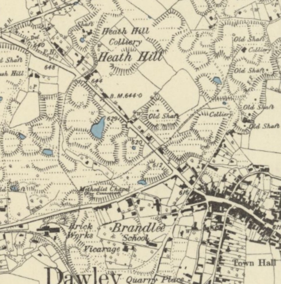
The Heath Hill Area
Returning the the area to the Southeast of Prospect House on the West side of Dawley. The other line, which has been obliterated by modern road construction, ran North to serve two small collieries in the Heath Hill area to the North and Northwest of Dawley village and which is just a few hundred yards from our Vicarage next to St. Leonard’s Church in Malinslee. The collieries can be seen in the OS Map extract below.
References
Barrie Trinder; The Most Extraordinary District in the World; Phillimore, London and Chichester, 1977.
C. von Oeynhausen and H. von Dechen; Railways in England 1826 and 1827; translated by E.A. Forward, ed. Charles E. Lee, Newcomen Society, 1971, p67, p73-74.
The area around what is now central Telford, and particularly the Severn Gorge and Coalbrookdale are known as the cradle of the industrial revolution. They are significant because of the major steps forward made in the production of cast and wrought iron.
The geology of the immediate area was a crucial factor in these developments. Limestone, coal bearing strata and iron ore were all easily available in the one, relatively small area. Initially the iron production processes needed charcoal, also readily available in the wooded areas which surrounded the Severn Gorge.
Because of the topography, mining at a relatively small scale was easier than elsewhere as mining could be done by ‘inset’ (horizontal galleries) rather than pits. The proximity of necessary materials meant that transport costs were lower than elsewhere.
At a very early time in the development of the area, relatively primitive railway technology was in use. It is difficult to be sure when a ‘railway’ was first used. Some general guidance on undertaking research, particularly into early forms of railways is made available by the Railway and Canal Historical Society to its members. [12]
Peter King tells us that some very primitive systems were in use in Europe over the centuries but “the earliest railway-like transport system … was the Leitnagel Hund. … Planks were laid along the mine passage with a gap between them, and the truck – hund (German for dog or hound) or truhe (box or chest) – had a guide pin that pointed down between the planks to keep the truck going in the right direction. The word hund could be derived from the Magyar hintó, meaning a carriage. If so, this points to an origin in the mines of Hungary, which at the time included Slovakia and Transylvania. The system was widely used in central Europe in the early sixteenth century, and may go back to the fifteenth or even the fourteenth century.” [1: p20]
The German system was introduced in the UK in Cumbria to ‘Company of Mines Royal’ sites at Caldbeck, Newlands, and Grasmere and also at that company’s mines at Talybont near Aberystwyth. King notes that “Documentary evidence indicates they used ‘small rowle wagons bound with iron’ in copper mines at Caldbeck …The first of these … near … Silver Gill at Caldbeck, where investigation has yielded the remains of some plank rails and possible sleepers.” [1: p20]
Historic England organised a survey of available material on the early tramroads. This was undertaken by David Gwyn and Neil Cossons. They report that, “The first railways in England probably date, at earliest, from the second half of the 16th century and were associated with mines where German-speaking miners were employed. Smith-Grogan 2010 suggests that several Cornish rutways might date back to the 1550s and be associated with Burchard Cranich and Ulrich Frosse. The West-Country mining engineer Sir Bevis Bulmer (1536-1615) was familiar with Agricola’s De Re Metallica (Skempton 2002), and another possible literary conduit is Sebastian Munster’s Cosmographia Universalis, published in German in 1544 and in Latin in 1550. This includes a woodcut of a hund on flanged wooden rails in a mine at Ste Marie/Markirch in Alsace (Lewis 1970, 51).” [5: p20]
Gwyn and Cossons note that excavations in Leicestershire of the Coleorton deep collieries which were active from 1460 to 1600 failed to identify any railway systems. They also assert that, “The first rail system in England for which both documentation and material evidence survives is the hund guide-pin system described in ER4 (Allison, Murphy and Smith 2010) in one of the Caldbeck mines exploited by the Company of Mines Royal financed from Augsburg, which was introduced by Daniel Höchstetter in the 1560s.” [5: p20]
King notes that the Hund guide-pin system “had some characteristics of a railway, but differs from them in that neither wheels nor rails were flanged.” [1: p21]
He continues: “The first railways were English. Their function was to carry coal from the pit (or adit) down to a navigable river (or less often to a highway) to be transported to a distant place.” [1: p21]
In King’s opinion it is likely that the first can be dated to sometime in the late 16th century. He identifies one serving “the mines of James Clifford near Broseley in Shropshire, which has no clear date of construction. As Clifford was mining coal by 1575, the funicular railway, by which coal was let down from mines to trows (barges) operating on the river Severn, is likely to have preceded the others. Nevertheless, William Brooke was working his coal mines in Madeley, on the other side of the Ironbridge Gorge, where similar problems would have arisen, but that is only known because Arnold Bean of Worcester owed Brooke money when he died in 1579.” [1: p21]
Gwyn & Cossons concur with King. They say that “documentation dating from the opening years of the 17th century indicates that wooden railways, ‘waggonways’, were being laid as overland systems, connecting a drift or a shaft-head with navigable water, or occasionally with an interchange yard on a road system.” [5: p22]
Like King, they say that most of what we know of these waggonways “comes from legal disputes, and for this reason it is quite possible that there were other systems of which historians are unaware because they prompted no quarrels.” [5: p22]
They also cite the waggonway which ran from a “colliery at Broseley near the Severn Gorge in Shropshire, on the south side of the river, to a wharf at the Calcutts, slightly downstream of the later Iron Bridge; it was laid in October 1605, was a mile or so long.” [5: p22]
King asserts that there were “a number of mines along the side of the [Severn] gorge in the succeeding period and each apparently had an associated railway. Some mines were pits, but some were ‘insets’ – mines operated through an audit, and in these cases the railway extended underground to the coalface.” [1: p22]
After these short notes, King turns his attention away from the Severn Gorge to other parts of the UK, commenting on pits just to the west of Nottingham (using a form of railway circa. 1605) and Belington in Northumberland (1608). He then focusses on the Newcastle area. Again earliest dates are uncertain but by 1660 wainways were in use with “waggons carrying 15 bolls (about 33cwt); from 1700 19-20 bolls (42-44cwt) and from the 1750s, 24 bolls (53cwt). At Gateshead, Old Trunk Quay was at the end of the Old Wain Trunk Way, operating in the 1629s. In 1633 Thomas Liddell as owner of Ravens worth Colliery still had a wainway leading to a staith at Dunston. … Three other waggonways were built before the Civil War. … By the latter part of the 17th century three different waggonways were made,ball reaching the Tyne at Stella. … Stella was about the highest point to which the Tyne was easily navigable.” [1:p23]
Gwyn & Cossons chronology parallels that put forward by King. They refer to a railway that “had been laid from Strelley pits to a yard at Wollaton in the Nottinghamshire coalfield.”
Gwyn & Cossons write of Huntingdon Beaumont (who owned the Strelley pits) introducing the waggonway to the north-east. “According to the Newcastle historian William Gray, ‘Master Beaumont a Gentleman of great ingenuity… brought with him many rare Engines, not then known in these parts, as… Waggons with one Horse to carry down Coales from the Pitts, to the Staithes, to the River, &c.’ Beaumont’s three railways were on the north-east coast, at Bedlington, laid around 1608, and at Cowpen and Bebside, undated but probably much the same time (Smith 1960, Lewis 1970).” [5: p22]
Gwyn & Cossons go on to say: “Railways in the north-east developed into systems of extraordinary density with a complex history, reflecting intense regional rivalries and the profits that could be made from supplying London with coal. Even so, it was not until 1621 that the first recorded waggonway was built to the Tyne and it was not until the Restoration of 1660 that they became common. In the meantime, wain-roads remained a more cost-effective solution for most coal owners (Bennett, Clavering and Rounding 1990, 35-56).” [5: p22]
King cites other examples of early waggonways which include a ‘coalway’ owned by Sir John Lowther of Whitehaven from 1683. His son, Sir James, had waggonways from the 1730s serving to transport coal from collieries into Whitehaven.
Another ran from Sheffield Park to Sheffield, others took coal to the navigable lengths of the Rivers Ayre, Calder and Dun. There were even waggonways in the north of Ireland.
King’s eyes then turn bank to Shropshire. He comments: “Shropshire railways … form a different tradition from Newcastle waggonways. The waggons were smaller because the mines were often insets (rather than pits). The railway often started at the coalface and a smaller waggon meant that only a narrow adit had to be made through dead ground. The descent to the river down the side of the Severn gorge was precipitous, and the descent was controlled using a self-acting inclined plane, something not used near Newcastle until the late eighteenth century, but probably in Shropshire for its first railway. Wilcox’s & Wells’ railway to Calcutts may have been down Birch Batch. Its terminus was later called Jackfield Rails, and it remained in use well into the nineteenth century.” [1: p25]
Gwyn & Cossons comments about the Shropshire coalfield mirror that of King. They say that the Shropshire coalfield “developed smaller capacity systems running on narrower gauges. Here, mines were mainly levels, rather than deep mines such as prevailed in the north-east, and so a compact waggonway could run from the coalface to daylight and then down to navigable water. The Severn Ironbridge Gorge and its immediate environs were home to many such railways. From the mid-18th century, similar waggonways also ran direct from ironstone mines to Bedlam furnaces downstream of the later Iron Bridge.” [5: p23]
King says that a “longer railway, ultimately from John Wilkinson’s New Willey Furnace of 1757, went down Tarbatch Dingle to Willey Wharf but was probably built in the 1700s to serve coalmines and remained in use in parts for some 300 years, though from 1862 it led to the Severn Valley Railway, rather than a river wharf. North of the Severn, the lords of Madeley had railways at Madeley Wood when they let their mines in 1692.” [1: p25]
They go on to say that the “establishment of new coke-fired furnaces in the 1750s and the expansion of mining led to the provision of further railways, the longest running from Ketley (near Watling Street) to Coalbrookdale Wharf on the Severn, so that by about 1775, Abiah Darby (the widow of Abraham II) stated that the Company had 20 miles of railways.” [5: p23] These comments are drawn directly from King [cf: 1: p25]
King notes that “Other railways ran to landsale wharfs on Watling Street. In all, five gauges of railway were in use in the area, with those wholly above ground probably of a similar size to those at Newcastle.” [1: p25]
Gwyn & Cossons found that railways deriving from Shropshire practice “were to be found in coalfields which were adjacent and technically influenced by it. Staffordshire and Warwickshire, as well as parts of Wales and of Scotland.” [5: p23]
Interestingly, Gwyn & Cossons assert that “the Tyneside system is the design-ancestor of the median-gauge railways of the present day, and in particular of the UK, continental European and USA gauge of 4′ 8″. Narrow-gauge railways derive ultimately from the Shropshire system, as the inspiration for the railways built in the heads of the South Wales valleys in the 1790s, subsequently adopted and developed in the Gwynedd slate. industry. This was then offered as a cut-price system suitable for the developing world by the Festiniog Railway’s engineer in 1870, when the great and the good were invited to see it in operation (Gwyn 2010, 138).” [5: p23]
“Tyneside systems ran on gauges of between 3′ 10″ and 5′, Shropshire systems of between 2′ and 3′ 9” (Lewis 1970, 181, 267). [5: p24]
“By the mid-17th Century tramroads were fairly common and continued to be so through the 18th century, so that by the start of the 19th Century they often ran for considerable distances, taking mineral products (notably coal) from their source to the point of consumption, or … to a canal wharf for onward carriage by boat.” [2]
Early tramways in and around the Severn Gorge and in East Shropshire as a whole are noted in works of Bertram Baxter, [4] Savage & Smith, [6] Catherine Clark & Judith Alfrey [13]
These include:
Benthall Railway [7][13]
Caughley Railway [8]
Gleedon Hill Tramroad [9]
Sutton Wharf Tramroad [10]
Tarbach Dingle Tramroad [11]
The Coalbrookdale Company Tramroads [12]
Deerleap Tramway [13]
Lime Kilns Tramway [13]
Ash Coppice Tramway [13]
Clay Mine Tramway [13]
This list is the result of a relatively limited search online and is unlikely to be comprehensive. Some of these will warrant further study, the links provided in the references are worth a read.
It is my plan to look at a number of these in coming weeks and months. The first will be the Coalbrookdale Company Tramroads.
References
Peter King; Before the Main Line; in ed. David St. John Thomas; How Railways Changed Britain; Railway & Canal Historical Society, Derby, 2015, p13 – 32.
Bertram Baxter; Stone Blocks and Iron Rails (Tramroads); David & Charles, Newton Abbot, Devon, 1966.
David Gwyn and Neil Cossons; Early Railways in England: Review and summary of recent research; Historic England, Discovery, Innovation and Science in the Historic Environment Research Report Series No. 25-2017.
R.F. Savage & L.D. Smith; The Waggon-ways and Plate-ways of East Shropshire, 1965.
https://rchs.org.uk/research-general-guidance, accessed on 19th April 2022 – particular reference is made to a document which gives a good sense of the development of various waggonways, tramways, plateways and Tramroads … Research-agenda.pdf which can be downloaded from the members area of the site.
Catherine Clark & Judith Alfrey; Research Paper No. 15, Benthall and Broseley Wood;Nuffield Survey, Third lnterim Report; University of Birmingham, 1987.


