
The November 1954 edition of The Railway Magazine reported that, “An improved type of steam-heating tender for electric main-line trains has been brought into use on the Cape Western and Natal systems of South African Railways. The new tenders are fitted with automatic oil-burning generators and are stated to be both cleaner and more effective than the former coal-burning type. A total of 16 tenders is being built. It is intended that eventually nine will be used on the Cape Western system and the remaining seven in Natal. The winter season, for train-heating purposes, lasts from May to October, during which period the tenders are in daily use on passenger trains. The nine tenders allocated to the Cape Western system will work between Cape Town, Worcester, and Touwsrivier when nthe passenger trains are taken over by recently-acquired class “4E” electric locomotives.” [1: p804]
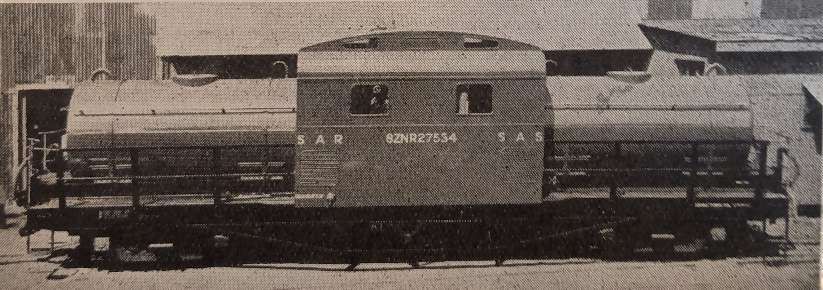
Oil-fired steam-heating tenders (often referred to as steam generator units or cars) were crucial during the transition from steam to diesel/electric traction in the mid-20th century, allowing diesel or electric locomotives to pull older passenger carriages designed for steam heating. These units held fuel oil and water, utilizing an oil-fired boiler to produce steam, which was passed through pipes to heat passenger carriages.
Some new diesel and electric locomotives in the UK had Steam Heat Generators designed into them when built, others had Steam Heat Generators fitted retrospectively. This was true within locomotive classes, for example: Class 76 locomotives were not uniform in at least this respect. EM1 & EM2: An Illustrated Historical Review of the Manchester, Sheffield, Wath, Electric Locomotives – 76s & 77s of 2014, [2] written by John Hooper provides a list of the Class 76 locomotives specifically focussing on Steam Heat Generators (SHGs):
No. 26000: SHG Fitted from new and left insitu;
No. 26020: SHG Fitted February 1955, Removed February 1966, Refitted July 1977 when taken into the National Collection;
No. 26046: SHG Fitted September 1955, Removed October 1963;
No. 26047: SHG Fitted May 1955, Removed October 1963;
No. 26048: SHG Fitted April 1955, Removed November 1963;
No. 26049: SHG Fitted July 1955, Removed November 1955, Refitted March 1956; Removed again circa. September 1970;
No. 26050: SHG Fitted from new, Removed June 1977;
No. 26051: Fitted from new, Removed December 1970;
No. 26052: Fitted from new, Left insitu;
No. 26053: Fitted from new, Removed October 1970;
No. 26054: Fitted from new, Left insitu;
No. 26055: Fitted from new, Left insitu;
No. 26056: Fitted from new, Removed November 1970;
No. 26057: Fitted from new, Removed July 1972.
This information was recorded in July 1981. [2]It begs a question or two. Did the designers not appreciate the need for steam-heating of existing passenger stock? Were, perhaps, some of these locomotives intended only for freight haulage?
I presume that retrofitting was more expensive than installation at the time the locomotives were built. So how much did the design and specification teams believe was to be saved by excluding SHGs from some locomotives?
These questions must also apply to the Electric Locomotives supplied to South African Railways. Was the decision taken to provide separate SHG tenders because the length of journeys involved meant that oil for the SHGs would have required a separate tender? Could the class “4E” locomotives not have been designed to produce steam from generators which used the electrical supply?
South African Class 4E Electric Locomotives
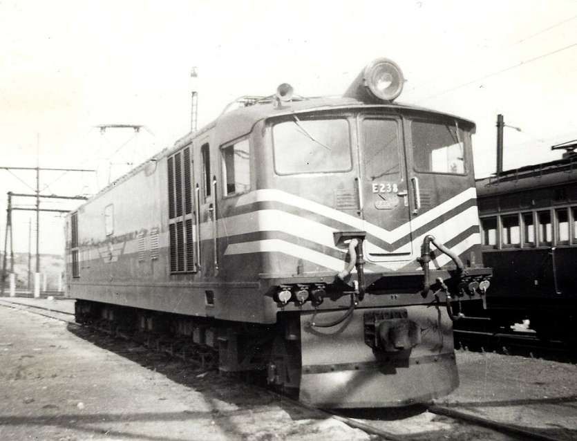
These locomotives were designed by the General Electric Company (GEC) and built by the North British Locomotive Company (NBLC). There were 40 locos in this class. They were numbered E219-E258. [4] It would seem that these locomotives may not have had SHGs in their as-built state.
Between 1952 and 1954, the South African Railways placed forty Class 4E electric locomotives with a 1Co+Co1 wheel arrangement in temporary service on the Natal mainline and from 1954 on the mainline from Cape Town across the Hex River rail pass to Touwsriver in the Karoo. [4][5: p126-127]
“The Class 4E was specifically acquired for use on the mainline from Cape Town across the Hex River rail pass to Touwsriver, from where Class 23 and later Class 25 and Class 25NC steam locomotives would take over across the stretch of unelectrified mainline to De Aar and from there to either Kimberley or Bloemfontein.” [4][5: p126-127][6]
“Since the completion of Eskom’s high-tension power feeds in the Cape was late, the first locomotives to be delivered in 1952 were placed in service on the Natal mainline while awaiting electrification from Wellington via Worcester to Touwsriver. They were to be transferred to the Cape as soon as the wires were energised, but they eventually had to be withdrawn from Natal earlier because the severe curvature of the Natal mainline caused their frames to crack.” [6][7: p15][8]
“Class leader no. E219 was the first unit to be relocated to Cape Town in March 1953, where it initially ran on the 1.5 kV DC power which was still being used for Cape Town’s suburban trains until the upgrading of the Cape Town lines to 3 kV DC was completed in November 1954. The 3 kV DC electrification from Worcester had reached Touwsriver in April 1954. Until then, the locomotive’s load capacity and mobility were restricted. In Cape service, some teething troubles were experienced with their bogies, particularly when going faster than 45 miles per hour (72 kilometres per hour). The problem was hunting which became increasingly severe at higher speed and the units were therefore employed mainly on goods traffic until 1956, by which time their bogie faults had been ironed out.” [7][9][10]
“The Class 4E was rated at double the load of a Class 15F without banker over the Hex River rail pass, 770 tons against 360 tons for the same train length. With assistance from a banker between De Doorns and Matroosberg, a Class 15F and Class 14CRM combination could almost match the Class 4E, but between Cape Town and De Doorns an unaided Class 4E could haul half as much again as a Class 15F, 1264 tons as against 820 tons.” [9]
“Two Class 4E units briefly served on the Western Transvaal System while being relocated from Natal via Transvaal to the Cape. That system was granted permission to use no. E247 and one other for between four and six weeks, working from the Electric Running Shed at Braamfontein, before the locomotives were forwarded to Cape Town.” [8][11: p9]
“From 1954 onwards, the Class 4E took over working of the Blue Train with increasing regularity, long before the last Class 15Fs were drafted away to the Cape Midland System in September 1957.” [9]
No mention is made of the need for tenders to operate with these locomotives to supply steam for carriage heating.
Historically, passenger carriages in South Africa were heated using steam heating systems powered by steam locomotives, or later via steam generators in diesel/electric locomotives. These systems supplied steam through pipes to heaters within the coaches. Other than the short piece in The Railway Magazine, I have been unable to find any reference to the need for SHGs with Class 4E locomotives.
There is, perhaps, one other possibility that might explain the use of these SHGs if the Class 4E locomotives did actually have steam generators. … The demand placed on the locomotive’s own steam generators with longer passenger trains travelling over high ground may have been too great in winter months. If so, a locomotive would then need its own generator supplemented by another.
References
- Notes and News; in The Railway Magazine November 1954; Tothill Press, London, 1954, p800-805.
- John Hooper; EM1 & EM2: An Illustrated Historical Review of the Manchester, Sheffield, Wath, Electric Locomotives-76s & 77s; Book law Publications, Parrot Books, Hemel Hempstead, Hertfordshire, 2014.
- https://en.wikipedia.org/wiki/South_African_Class_4E#/media/File%3ASAR_Class_4E_E238.jpg, accessed on 24th March 2026.
- https://en.wikipedia.org/wiki/South_African_Class_4E, accessed on 24th March 2026
- Leith Paxton & David Bourne; Locomotives of the South African Railways; Struik, Cape Town, 1985.
- Soul of A Railway, System 6, Part 1: Durban Old Station (Caption 21) – the link is no longer active. Archived 24th October 2020 at the Wayback Machine, accessed on 24th March 2026.
- Les Pivnic; South African Railways & Harbours Photo Journal, Vol. 6.
- Soul of A Railway, System 7, Western Transvaal, based in Johannesburg, Part 3. Johannesburg Station in Transition by Les Pivnic. Caption 26 – the link is no longer active, however, the project can still be accessed via: https://sites.google.com/site/soulorailway/soul-of-a-railway/system-7-western-transvaal?authuser=0, accessed on 24th March 2026.
- Soul of A Railway, System 1, Part 2: Cape Town to Wellington. Captions 22, 23, 32 – the link is no longer active, but the project can still be accessed via: https://sites.google.com/site/soulorailway/soul-of-a-railway/system-1-cape-western?authuser=0, accessed on 24th March 2026.
- Soul of A Railway, System 1, Part 4: Touws River to Beaufort West Caption 5 – the link is also no longer active, but the project can still be accessed via: https://sites.google.com/site/soulorailway/soul-of-a-railway/system-1-cape-western?authuser=0, accessed on 24th March 2026.
- Les Pivnic; South African Railways & Harbours Photo Journal, Vol. 19.
