
Mohill to Ballinamore
 We re-start our journey at Mohill Railway Station which is to the South of the little town. This is the likely long-term terminus of the preservation railway of the Cavan & Leitrim Railway, Station Road, Dromod, Leitrim, Ireland. Email: dromodrailway@gmail.com. Tel: 00353-71-9638599.
Mohill (Irish: Maothail) or Maothail Manachain, is named for St. Manachan, who founded the Monastery of Mohill-Manchan there c. 500-538AD. Some sources and folklore say the shrine of Manchan was kept at Monastery of Mohill-Manchan, before being moved to Lemanaghan in county Offaly for some unrecorded reason. The Monastery was taken over by Augustinians in the 13th century and was later closed in the 16th century, after the time of King Henry VIII. The site of the church is now occupied by a Church of Ireland church and graveyard. [4]
Ownership of the town passed to the Crofton family during the plantations and areas around the town were owned by the Clements family (Lord Leitrim), who built the nearby Lough Rynn estate and was also the owner of what is now Áras an Uachtaráin. Mohill Poor Law Union was formed 12 September 1839 and covered an area of 215 square miles (560 km2). The population falling within the union at the 1831 census had been 66,858. The new workhouse, built in 1840-42, occupied a 6-acre site and was designed to accommodate 700 inmates. During the great famine, Anthony Trollope wrote a voyeuristic narrative on Mohill in his novel The Macdermots of Ballycloran, an early work. [4][5:p51-52]
Hyde Street is named after Rev Arthur Hyde, grandfather of Douglas Hyde, first President of Ireland, who spent part of his childhood in the town. Through at least the 19th and 20th centuries, an impressive number of annual fairs were held at Mohill (14 each year!).[4][6:(1819: p405] Back in 1925, Mohill town had population of 755 people, and contained 29 houses licensed to sell alcohol. [4][7:p33]
“Mohill railway station opened on 24 October 1887 and finally closed on 1 April 1959. [8] It was a Class 2 station and had two timber platforms, with buildings (similar to those at Dromod) on the down side. Although aways a staff station, it was not a crossing-place as the loop was not long enough. The up platform had a small shelter and, at the Dromod end, a water tank. The first tank dated from the opening but was replaced in 1892 by one from Arigna. In 1920, it was joined by a tank originally placed in Ballyduff but which had been used in the building of the Arigna Valley Railway. A third tank on a concrete base was installed just inside the goods yard in 1927, bringing the total capacity to 1,000 gallons. There were never any water facilities on the down platform and thus engines of down trains had to go across the road for water. Up to 1921, the water was hand-pumped, but an oil-engined pump was then provided; in turn, in the 1930s, it was superseded by the town supply.” [1:p127]
“Goods facilities were poor at first, although a store was built for the opening and a crane, by Manisty of Dundalk, was added in 1890. Originally, there was only the single store road but a short siding was laid at the back of the station-house in 1890 and another parallel to the store road, in 1896. All were considerably lengthened at later dates. The station was signalled from two ground frames, one at the gates and the other at the Dromod end of the loop; both had wooden protective shelters until about 1925.” [1:p127]
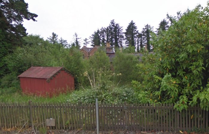 Mohill Station in 21st Century, screened from Station Road by trees and undergrowth. There are pictures in the last post in this series of the station as it is in 2019. The building which appears to be a garage in the front of the picture is actually a small corrugated waiting shelter which sat on the platform furthest from the main station building.
https://rogerfarnworth.com/2019/05/19/the-cavan-and-leitrim-railway-dromod-to-mohill.
A Video of the use of the station building in 2017. [11]
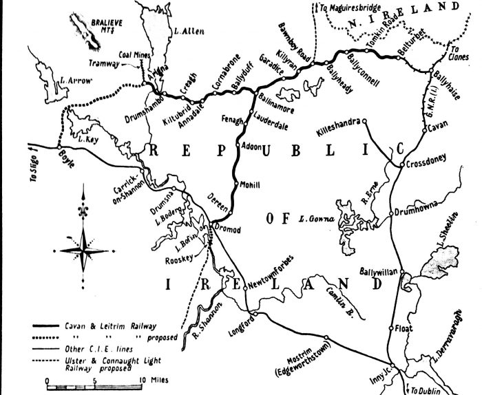
Three stations are ahead of us before we reach Ballinamore – Adoon, Fenagh and Lauderdale. The route to Ballinamore is set aside in the Local Development Plan as a Greenway. The Greenway is intended to run from Mohill to Belturbet along the route of the Cavan & Leitrim Railway. [13]
The route is 41 kms (26 miles ) long and consists of three sections:
Section 1. Mohill – Fenagh – Ballinamore, 15 kms
Section 2. Ballinamore – Templeport – Ballyconnell, 16 kms
Section 3. Ballyconnell – Belturbet. 10 kms. [13]
Almost the entire route remains intact and the ground is remarkably level due to a series of cuttings, embankments and bridges. It provides access to a rich variety of local landscapes including bogs, drumlins, woodland, lake and canal side views, working farms and the UN recognised Marble Arch Caves Geopark in Co Cavan. Much of the route is in the foothills of the Sliabh an Iarainn and Sliabh Rushen mountains. [13]
The project is inspired by the significant increase in cycling and walking activity in recent years and the unsuitability of the local roads. Also, the opportunity to become a more attractive tourist destination. Similar initiatives in rural Ireland have transformed local economies by providing significant opportunities for area enterprises and employment. [13]
The first section begins at Mohill close to the former railway station. The Loc Rynn amenity is about 4 km away and has developed a variety of outdoor facilities in activity tourism along with formal gardens and woodland. Mohill station was an important station because in addition to the passenger traffic, the town hosted two great fairs on February 25th and October 19th annually. At its peak in 1945, 106 wagon loads of livestock were handled at Mohill.
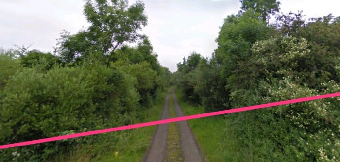
After leaving the town at 3.2 km distant is Gortfada Road, the first of eight level crossings before Ballinamore where the former stone built Victorian era station house is still in use. This is the case at almost all the level crossings. Adoon is over 7 km from Mohill, the site of a former ‘Halt’ and served Cloone village approx 4 kms away. The landscape is predominantly flat but the route follows a very slight uphill gradient which continues to Fenagh with several curves along the way to navigate the drumlin landscape. The landscape is very rural with a variety of pastureland, woodland, bogs, streams and lakes.
About 10 kms from Mohill is the former Fenagh station. Fenagh area has some of the most significant ecclesiastical heritage sites in the North West as well as Megalitic and pre-Christian sites. … Fenagh is also a summit point on the Greenway in that the overall gradients start to fall towards Ballinamore. At Lauderdale, the gradient is falling at 1 :47 over almost a kilometre on the approach to the canal bridge, the Dromod bound coal trains would have been working near their limit getting to Fenagh! Lauderdale crossing is approx 1 km from the newly refurbished Glenview Folk museum at Aughoo Bridge. Approaching Ballinamore, the canal bridge is now removed so the Greenway would follow the new canal side walk along the Shannon Erne Waterway for approx 3 kms before entering Ballinamore Marina at the south end of the town. [13]
In the image below we cross Station Road and head North though Mohill.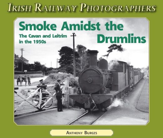 This book is an excellent photographic record of the line in the 1950s. It is published in the series ‘Irish Railway Photographers’. The image on the front cover defines the value of the book. It is a record of a line which wandered its way through a remote rural area. In the cover picture, the postman waits with his bicycle, and the farmer demonstrates as much patience as the donkey pulling his cart, while class FN1 2-4-2T No. 12L departs northwards from Mohill Railway Station. The author says that “This is a vignette of a more leisurely, but long vanished, way of life; postmen now drive vans and farmers have long-since traded-in their donkeys for tractors!” (c) Anthony Burges [2: front cover & p21]
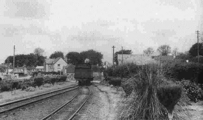 Looking North across the level-crossing from Mohill Station in 1950, (c) H.C. Casserley. [12]
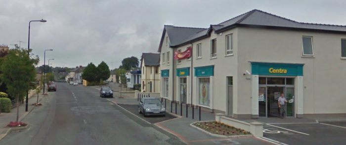
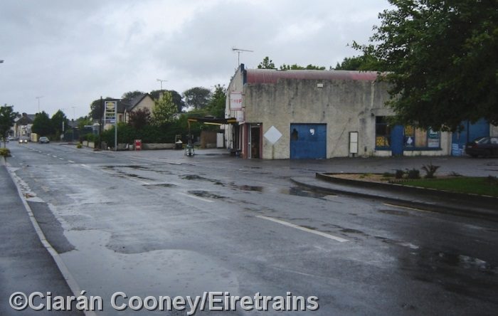 This view looks North from the station site in Mohill. Ciaran Cooney writes: “The small level crossing at the north end of Mohill Station has been totally obliterated by road widening, and the garage seen here has been extended much since railway days. The former line continued straight ahead between the cream-coloured house on the left and the garage on the right, the latter has since been demolished and replaced by a Centra store.” The store is visible on the satellite image below and in the pohotgraph from Google Streetview, also below. [10]
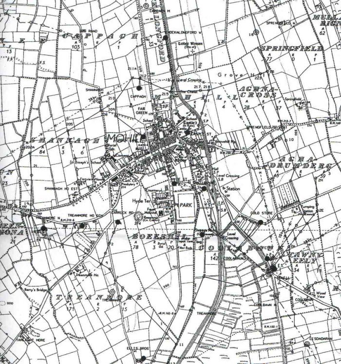 Mohill in 1911. [9]
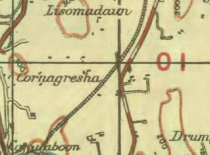
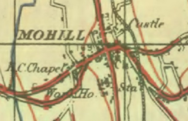 Mohill on the 1940s OS Map (GSGS One-inch). [3]
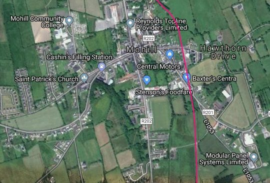
 Google Streetview picture looking North across the location of the level-crossing at the North end of Mohill Railway Station site in 2009.
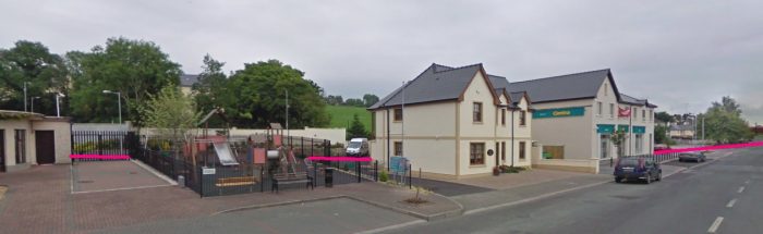 The approximate line of the old railway passes under the Centra store ind towards the back of the new property to its left before continuing on behind the fire-station (just off the picture to the left).
Immediately beyond the crossing, “There was a stiff climb at 1:57 past Hill Street gates and then a reverse curve.” [1:p127]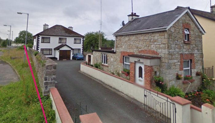
 The approximate route of the old line (above) approaching Hill Street level-crossing is shown in pink. The crossing-keeper’s cottage is still present in this 2009 image.
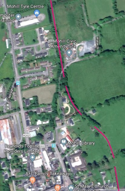
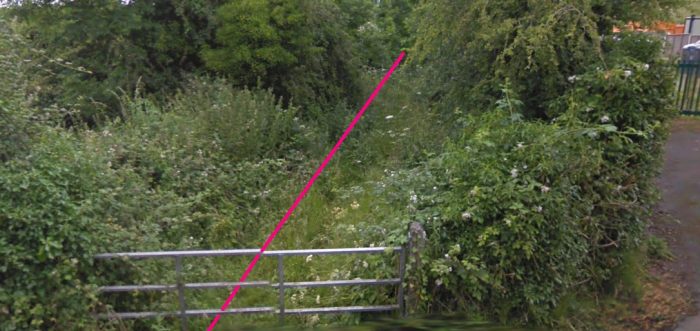
The reverse curve referred to above is visible on the 2009 satellite image adjacent to this text. The old line can easily picked out from above. Just fater the reverse curves were passed the line crossed Water Street which was a minor country lane.
The first picture below looks back from Water Street along the line towards Mohill Station. The second image looks forward along the line towards the North.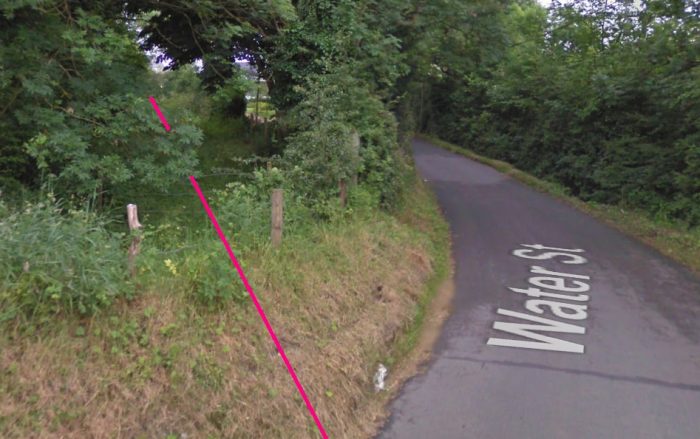
 The planned green-lane follows the route of the old railway. The local development plan protects the route of the line! [13]
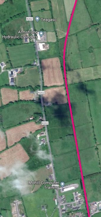
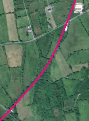
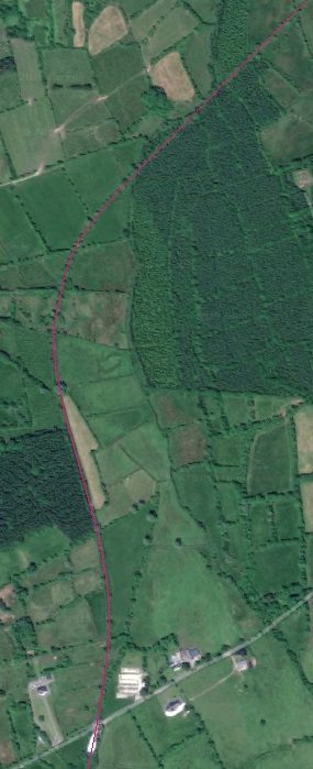
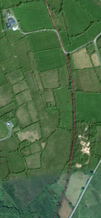
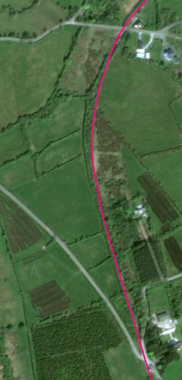
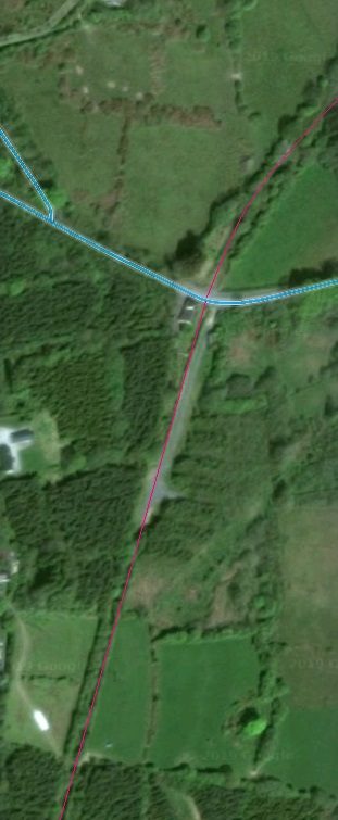
The fact that the line is protected gives us a very clear indication of its actual route. The adjacent satellite image shows the length of the old line North of Water Street. For a time it runs parallel to the R202 road running North out of Mohill. It then curves away towards the Northeast.
Thelp line was initially only on a very slight grade along this length but as it turned to the Northeast the grade steepened to 1:36 before the line reached Gortfada Crossing a little over 7 miles from Dromod.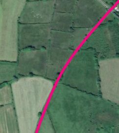
From February 1888 to January 1901, “market trains stopped at Gortfada, although the name Rosharry was always used. Just under half a mile farther on the line reached the actual Rosharry gates, and trains called here from 1901 until December 31st, 1920, by which time it had been decided that receipts did not justify the stop. At both Gortfada and Rosharry trains used simply to stop at the house, as there was no platform at either place.” [1:p128]
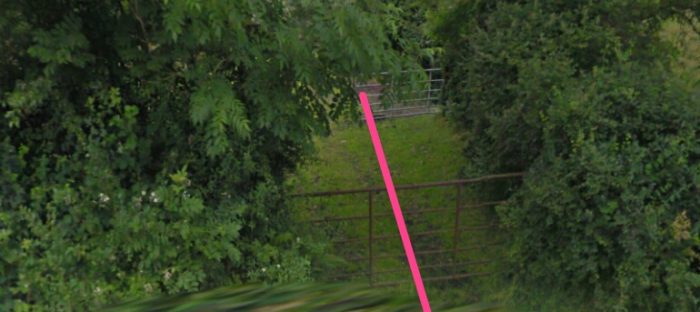
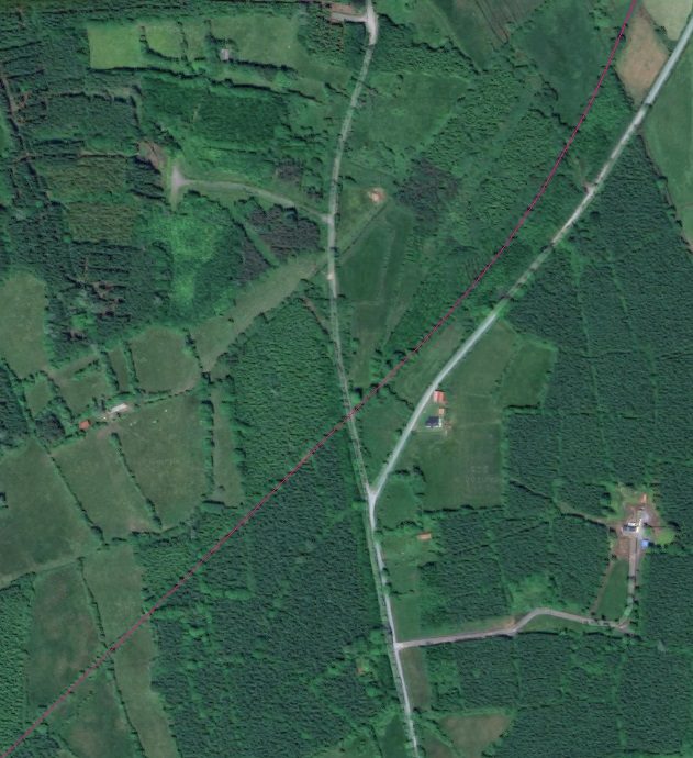
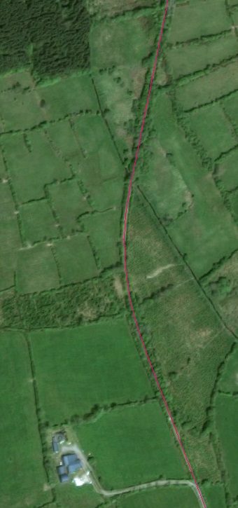
Both level-crossings are shown on Google Streetview images below, and appear on the satellite image immediately below these notes. Gortfada appears in the bottom left of the image and Rosharry, close to the top right, as the line begins to curve back towards a northerly alignment. North of Rosharry Crossing the line curved sinously through the landscape. It rose to a peak at the 9 milepost, then dipped and rose sharply to enter Adoon Halt just over 10 miles from Dromod at a gradient of 1:40. [1:p128]
The satellite images and maps below show the alignment of the railway through the landscape.
 Gortfada Crossing in 2009. This view looks back towards Mohill.
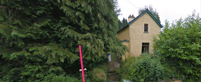 Gortfada Crossing, once again in 2009, looking forward to Rosharry Crossing. The crossing keeper’s cottage is still standing.
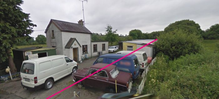 Rosharry Crossing looking back towards Mohill in 2009. The Keeper’s Cottage still stands and the approximate line of the railway is shown on this Google Streetview image. The keeper’s cottages were of a standard design along the line.
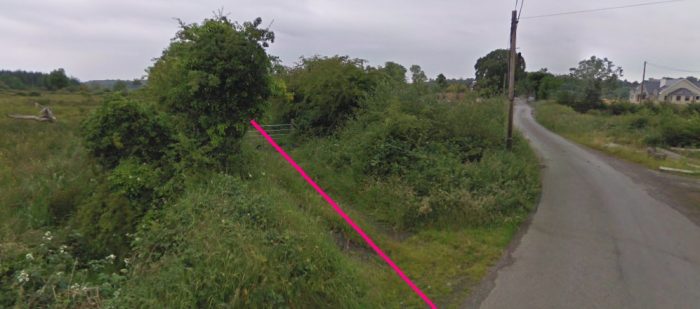
 Rosharry Crossing, above, also in 2009, but this time looking on towards Ballinamore.
Rosharry Crossing appears at the bottom of the adjacent satellite image.
The line heads north then northeast before crossing the minor road shown on the satellite image below. The subsequent 1940s OS Map shows that road as leading nowhere. It has since become a tarmacked lane, as shown in the image below the OS Map.
 A view, above, from the main road to the South, showing the approximate alignment of the railway as it crosses what on the OS Map was a short length of tarmacked road which is now tarmacked for some distance to the North.
The line continued through open country crossing one farm access road at an un-gated crossing (shown on the adjacent satellite image) while singing gentle round from a northeasterly to a northwesterly trajectory and then reversing back towards the North once again.
The route to Adoon was through open countryside and
Adoon had a shelter on the platform on the up side. “The halt-keeper’s house was 135 yards on the Dromod side at the gates, but it was not feasible to have the platform there on account of the gradient. In December 1887, the stationmistress complained about the bad road from the house to the halt and it was reported that her husband declined to let her carry out the traffic work for the small pay proposed. (The C&L invariably referred to the women halt-keepers as stationmistresses. They earnedone shilling a week for issuing tickets and got five per cent commission on receipts, as well as a free house.) In the halts, the booking-office, with its ticket window and drawer, was situated in the house and not the shelter. Receipts were sent to the controlling station in locked leather money-bags, of which there was one for each halt with its name inscribed on a brass plate.” [1: p128]
In the 1940s, a telephone was installed and Adoon was used for a while as a temporary block post (see 1: p172-174); otherwise it was never a staff station, “although there was a proposal at the start to cross trains using the long siding then there. (Construction trains were, in fact, so crossed.) The siding was little used and was removed in 1894. Afterwards, however, the need for a new one grew and an up facing siding was brought into use in July 1902. It ran in behind the passenger shelter and was protected by a trap point; it was comparatively little used in latter days.” [1:p128]
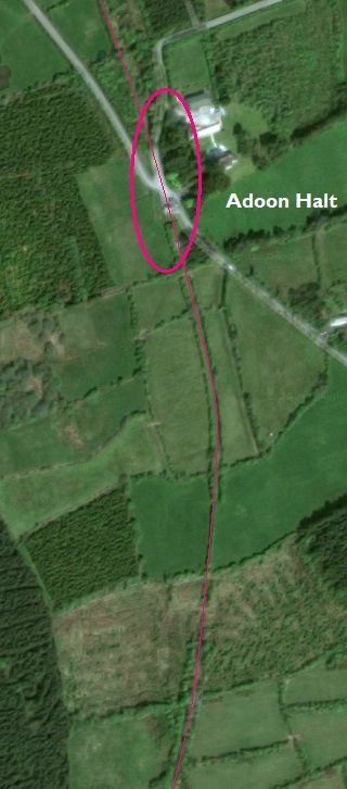
Adoon halt was just to the North of the road junction highlighted on the adjacent satellite image. Two monochrome images are shown below which give a good impression of the spartan nature of the station site.
The crossing-keeper’s cottage is not visible in either of the contemporary black and white images but it still remains a little to the south of the station site. It can just be picked out within the pink oval on the adjacent image.
Pictures showing the cottage in the 21st century are below the monochrome images. It is difficult to relate the modern images to the older 1950s images. It appears that there has been some local regrading of the site.
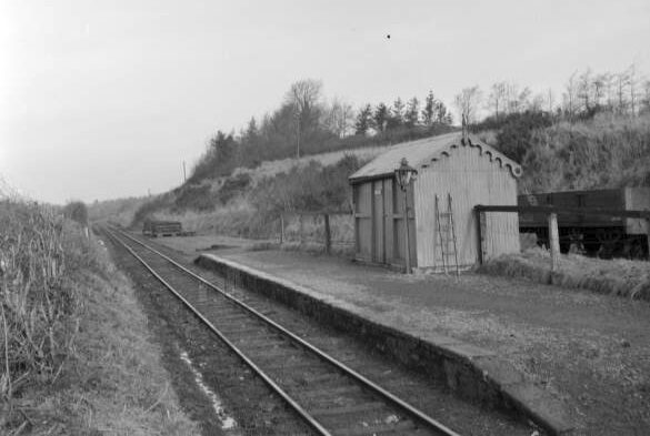 Adoon Halt in February 1959, (c) James P. O’Dea. [14]
 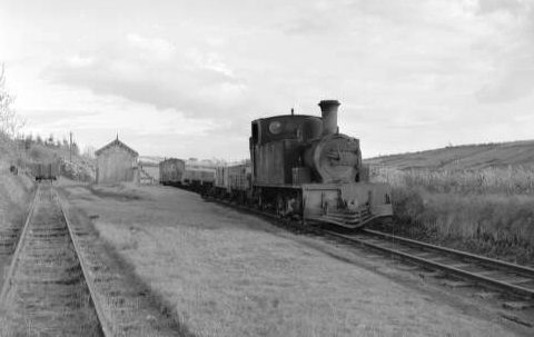 Adoon Halt in April 1959, (c) James P. O’Dea. [15]
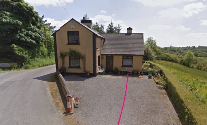 The Crossing Keeper’s Cottage in June 2009. It has been extended across the old railway line, the approximate course of which is shown in pink. The halt is behind the photographer. The view shown looks back towards Mohill.
 Looking ahead through the site of the station towards Ballinamore. There has been some revision to levels in the vicinity of the level-crossing and the station. The main road, to the left, remains in roughly the position it was during the life of the railway line.
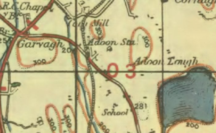
 At the time that the railway was active the road on the right of the colour picture immediately above this OS Map was merely a farm access road. By 2009, the road had become a through road running East to the North side of Lough Adoon. [3]
Ahead, the railway curved round to the Northeast again and crossed another minor road at a gated crossing where the keeper’s cottage still remains. Unfortunately the camera used for the Google Streetview images had pick up an un-noticed bit of tree branch while running along this narrow lane. The pictures of the keeper’s cottage are not worth including in this post.
After the Crossing the old line curved back round to the North once again as shown in the satellite image below.Short-lived, of course, as the route of the line through the countryside was sinuous. One author attributes this to the glacial drumlins which covered the area after the last ice age! [2]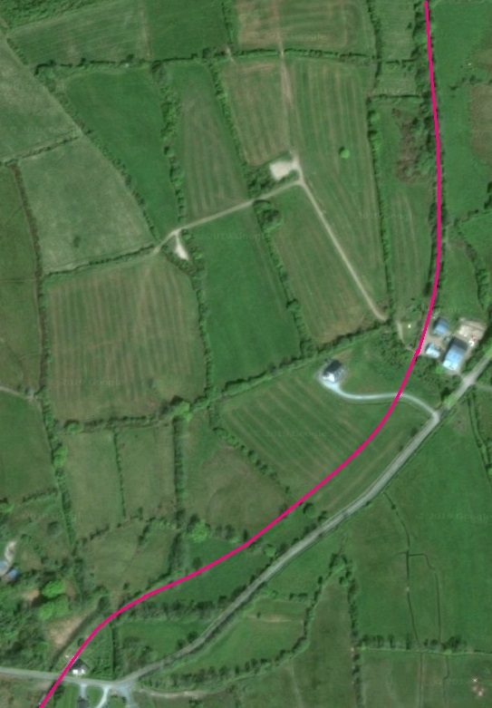
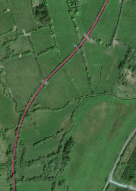
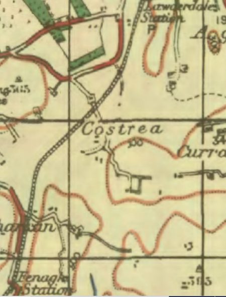
 The OS Map from the 1940 picks up the sinuous nature of the line. There are hardly any straight sections on the run from Adoon to Fenagh Station.
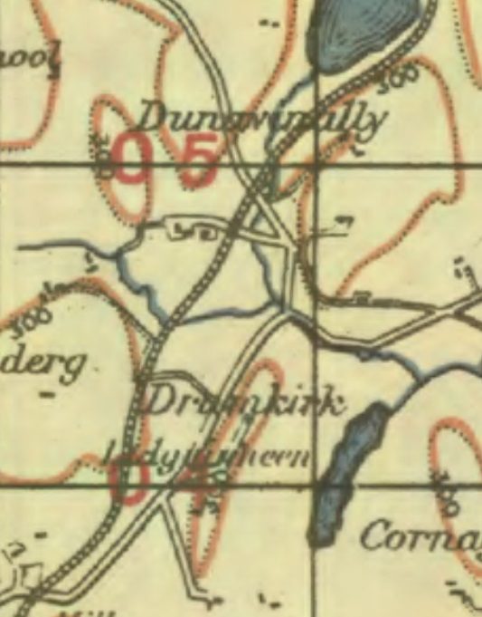
The adjacent OS Maps highlight a number of level-crossings along the route. Two at Dunavinally and one in the run towards Fenagh Station.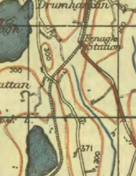
The first of these locations is picked out on the satellite image below. The Eastern length of the old lane which resulted in the more southerly of these two crossings is no longer used as a roadway. The farmer has chosen to use the old C&L formation to access the national road network instead.
The road layout is marked in blue on the satellite image, with the old lane marked by a dotted blue line. The railway route is marked in pink. The first picture below the satellite image shows the old rail formation in used as a farm access route.
 This picture was taken at Location ‘1’ above, looking back towards Adoon. It shows the diverted farm access track using the C&L formation.
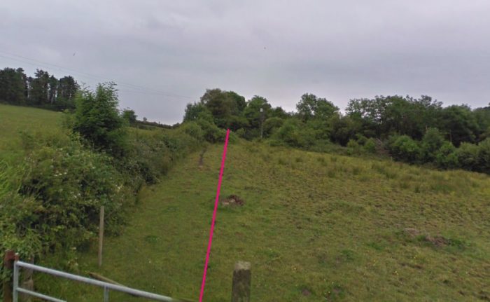 The route of the rail line ahead. It is not too far now to Fenagh.
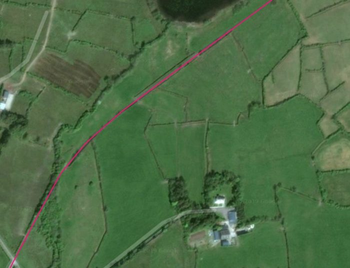 The line continues on, past Lough Drumroosk.
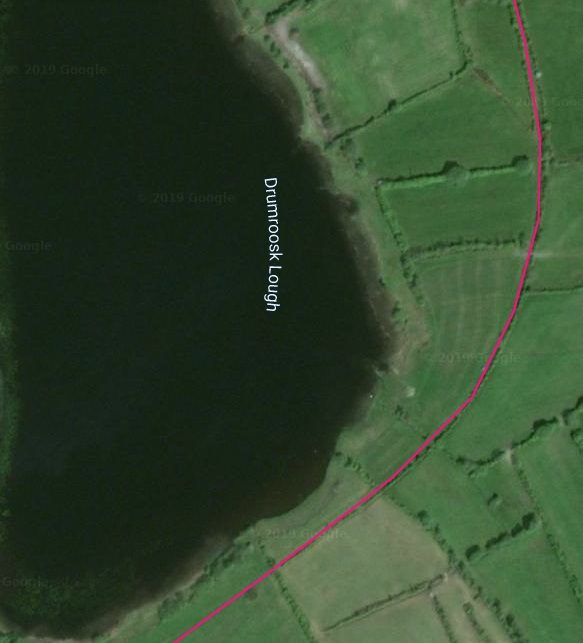
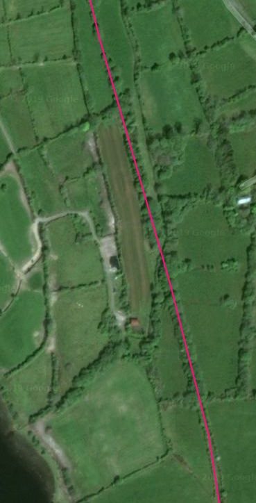
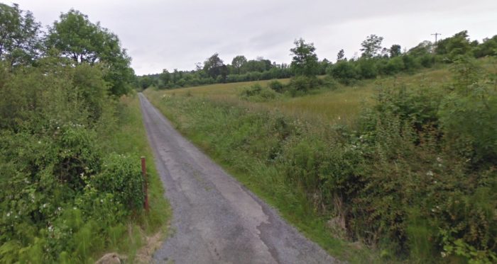
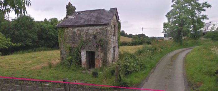
 The crossing closer to Fenagh is shown on the satellite image below. It is in the townland of Cornafostra. The view of that crossing point below was taken in June 2009 and shows the crossing-keeper’s cottage in a rather delapidated state.
The line curved to the Northeast and then swung back towards the North close as it entered Fenagh Station.
Fenagh was nearly 13 miles from Dromod. The route there from Adoon had maximum graidents of 1:39 and 1:47.
“The halt had the agethouse, shelter and platfrom on the up side; there was a short up, trailing siding. At Fenagh (as at Kiltubrid, Ballyheady and Garadice) the shleter was fitted in 1888 as a lock-up good store. The only incident recorded here was the overturning of a covered wagon with four tons of goods in December 1913 by a sudden gust of wind. The C&L had considered the installation of Mr Stott’s anemometers in December 1887 but did not, in fact, do so, and and was never unlucky enough to suffer the storm damage of the Lough Swilly or West Clare lines.” [1:p128-129]
The area was the site of the battle of Fidhnacha in 1094. [16][17]
Fenagh Abbey is one of the oldest monastic sites in Ireland, believed to date back to the earliest period of Celtic monasticism. The founder was St. Caillín, thought to have arrived in Fenagh from Dunmore in County Galway in the 5th century (according to the Book of Fenagh). The Abbey had a monastic school, and was celbrated across Europe for its divinity school. [16][18].
 The crossing in Cornafostra. The line ran in the foreground, to the east of the old cottage.
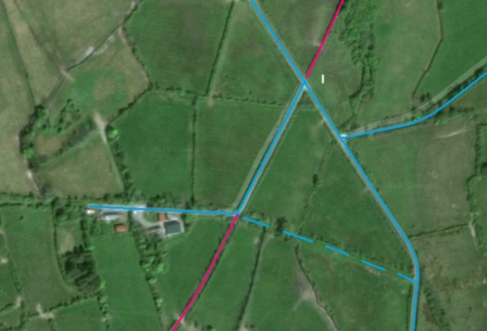
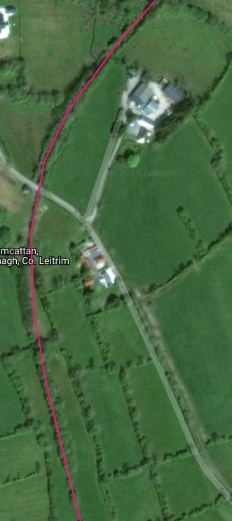
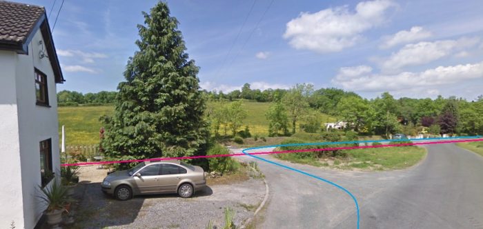 Fenagh: the old road layout and the route of the railway are shown in blue and pink respectively. The old crossing keeper’s cottage features in a renovated state on the left of the image. The picture is taken looking just a little to the West of North!
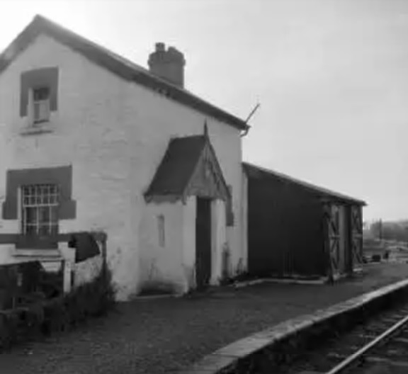 The station house at Fenagh while the C&L was still in use. [19]
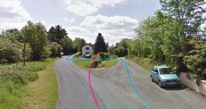
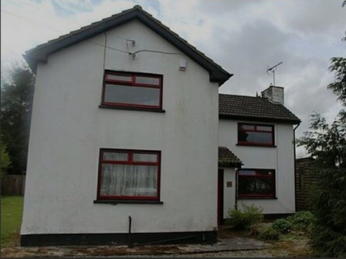 A view of the extended station house/crossing keeper’s cottage in the 21st century. [20]
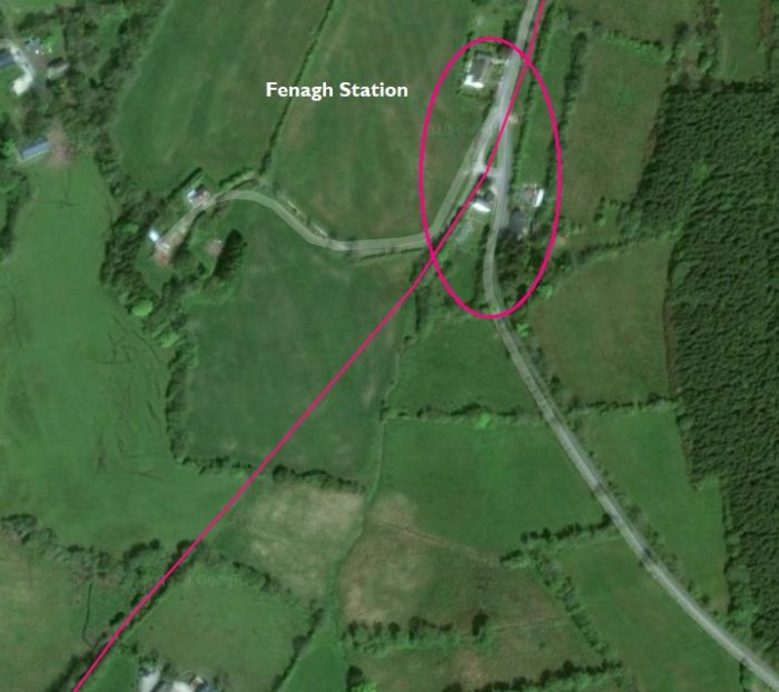
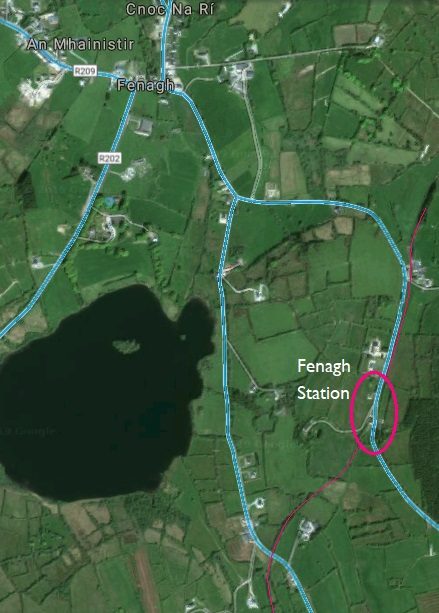
Looking back (above) through Fenagh Station site South towards Adoon. The approximate alignment of the C&L is shown in pink and the old road alignment in blue.
Those colurs are maintained on the adjacent satellite image which emphasizes just how far Fenagh Station was fro the village
“Leaving Fenagh, the line fell at 1:63 and then, after a rise at 1:60, descended the formidable Lawderdale bank. There was a long half-mile fall at 1:47, and the going was really tough for up trains, especially laden coal specials. Lawderdale Halt was at 14.25 miles and had the usual facilities on the down side. An added attraction of the place was the syringa bush, in a white-washed stone base, which Mr Lawder planted on the platform in 1903. The C&L name for the halt was ‘Lawderdale’, although CIE sometimes used ‘Lauderdale’; in fact, both were incorrect, Drumrane being the proper name. However, the C&L never even considered this and the halt was named ‘Aghoo Bridge’ in the early plans. [1:p129]
“Just at the Dromod end of the platform there was a down, facing siding which lasted until about 1940. It was installed in 1887-8 at a cost of £42 10s at the request of Mr Lawder, who guaranteed 100 tons of traffic a year. In the early days there was a weigh-bridge (jointly paid for by the C&L and James Ormsby) but all traces of it have long since disappeared.” [1:p129]
The first picture below shows a view looking back in a southerly direction from the level-crossing location at Lawderdale Station. The crossing keeper’s cottage it still in place and it has been modernized and extended. The old platform face is also still visible. It is easy to locate the old C&L in the landscape.
Looking North, in the second image below, the line curved away to the Northeast before then swinging back to the North.
 Lawderdale Station looking South.
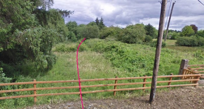
 The same location, looking North.
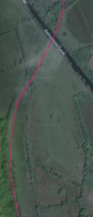
Half a mile past Lawderdale, the line crossed the ill-fated Ballinamore & Ballyconnell Canal over a single-span girder bridge. Sadly, I have been unable to find any photographic record of this structure.
The Ballinamore-Ballyconnell Canal was built to link the rivers Shannon and Erne.
Work on the canal began in 1846, after four years of planning. It was a huge project. At one stage, 7,000 men were working on the canal. Construction took sixteen years and the canal finally opened in 1860. However, during the years it took to build the canal, another form of transport had taken over. Railways had become the most popular way to transport goods. This was a blow for the Ballinamore-Ballyconnell Canal. It closed after just nine years. During that time it carried only eight boats – less than one a year! [21]
“In 1887 the Cavan and Leitrim Railway … opened. … This railway system served the same area as the waterway; however, it is clear that by the time the railway was being constructed the waterway was well and truly out of use, as indicated by the construction of very low bridges over the channel, indicating a level of confidence that there would not be a need to raise them. ” [22]
Recently, the canal has had a new lease of life. It re-opened in 1994 and is now a tourist attraction. It was renamed the Shannon-Erne Waterway. These days, cruisers and barges are a regular sight on the canal! [21]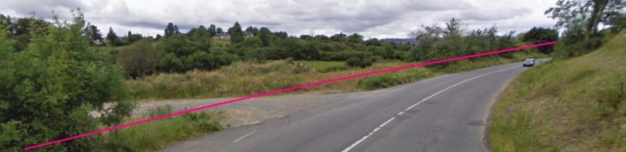 The line ran alongside the R204 for a distance north of the canal.
After the C&L crossed the canal there was a “rise of 1:40 followed immediately by a descent at 1:35, after which the line curved right on an embankment and then, in company with the tramway which swung up on the left, passed Tully level-crossing. A left-hand curve brought the line, falling at 1:87 into Ballinamore station.” [1: p129] By this stage we have travelled 16.25 mikes from Dromod.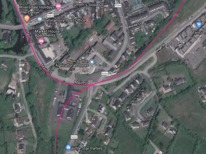
 Mainline and tramway (branch-line) ran in parallel into Ballinamore Station. A tramway loop opened out on the left and the three roads together crossed Cannaboe level-crossing and entered the station site which is marked above with a green flag.
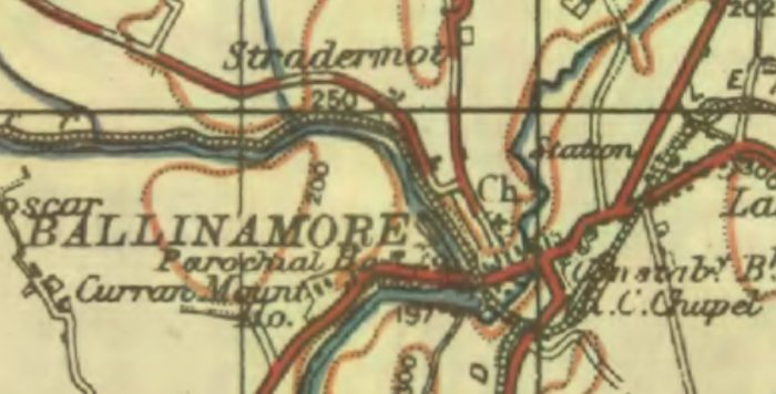 The 1940s OS Map of Ballinamore. [3]
Patrick Flanagan describes Ballinamore Station as follows:
“As at all the other main stations, the buildings were on the down side. Built at a cost of £11,8001, they were extensive and comprised traffic manager’s, booking and stationmaster’s offices, at well as waiting- and store-rooms and the agent’s accommodation. Outside the waiting-room was the brass station bell (provided in 1897). Immediately on the Dromod side of the building was the tramway bay platform with its own release loop outside. Opposite was the up platform which had a small shelter. The platforms were connected by a footbridge made by Manisty in 1890 and warning notices were attached. The original notices had disappeared by the 1920s but the GSR later affixed standard bi-lingual plates.
Baiiinamore, too, had a refreshment-room. The question of providing one was considered as early as November 1888, and although the board’s reaction was favourable it was ‘very dis-tinctly remarked that neither here nor hereafter (would) a licence be allowed’. A room was opened, the catering being done by a Ballinamore hotelier. It closed in 1891 and the service was not again provided until 1898, when the shelter on the up platform was used. But it, too, had a very short life and closed about 1902, later becoming an oil store.
The station was graded as Class i (allowance £85) and was unusual in boasting two signal cabins, one near the loco yard and the other at Cannaboe gates. They dated from the early 1890s and one lasted until 1956. The station signalling was then completely overhauled and a ground frame at the Dromod end of the tramway platform replaced the cabin at the gates. A second frame was installed on the site of the old yard cabin.
The signalling arrangements were interesting, being by far the most elaborate on the section. But the C&L never had a signalman — the job of making the roads fell to the guards or shunters who, at the end, at any rate, also had to open the gates for trains off the tramway.” [1: p130]
There were suggestions made in the early 20th century that the two cabins/ground frames should be replaced by one elevated central cabin. This, however, never came to pass.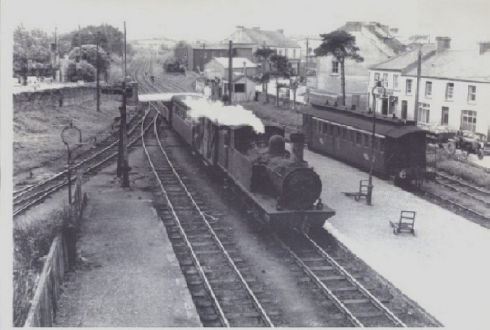 Ballinamore Station: the view from the footbridge South towards Dromod and Agrina. [23]
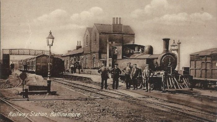
 Ballinamore Railway Station in the 1920s (above). [24]
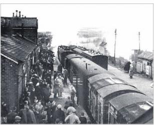
The adjacent image shows a busy scene at Ballinamore. [27]
Below, 4-4-0T 4L in front of the pair of Cork Blackrock 2-4-2Ts 21st March 1959. Formerly named ‘Violet’, 4L dated from the opening of the line in 1887. [29]
 In this image, the station footbridge just intrudes on the left and the station building at Ballinamore can be seen beyond the loco.
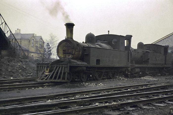
 Narrow Gauge Loco On Goods Train At Ballinamore In 1951, the shed roads can be seen behind the Loco. [25]
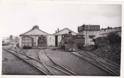 Ballinamore Shed. [26]
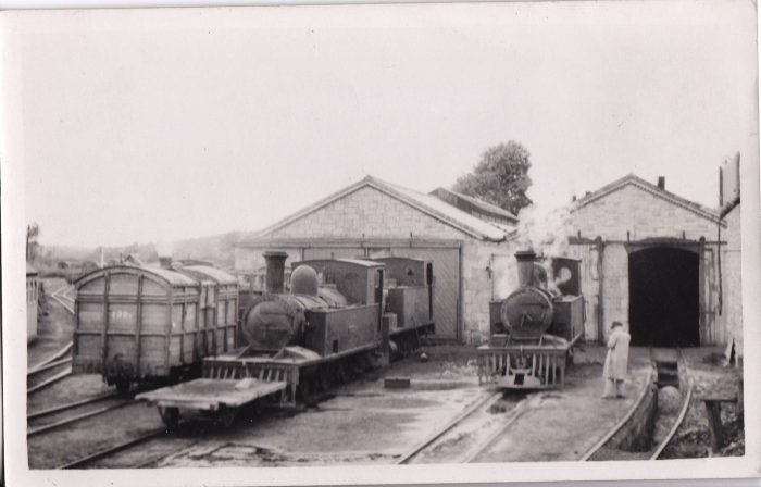 The shed roads at Ballinamore once again. [28]
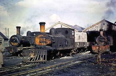 Three locomotives on shed on the Cavan and Leitrim Railway. No 4 is Robert Stephenson and Hawthorn 2615 1887 4-4-0T No 4 VIOLET Withdrawn in 1959 and cut up at Dromond in 1960. No 10L is Neilson, Reid & Co. No. 5561 of 1900;2-4-2 tank. Ex CB&PR. In service till closure 1959. The other cannot easily be identified. [30]
 C&L locos numbers 1 and 3L, 3L “Lady Edith” like many an Irishman emigrated to America and is now preserved at the Pine Creek Railroad, it hasn’t steamed in some time, (c) John Wiltshire 1955. [32]
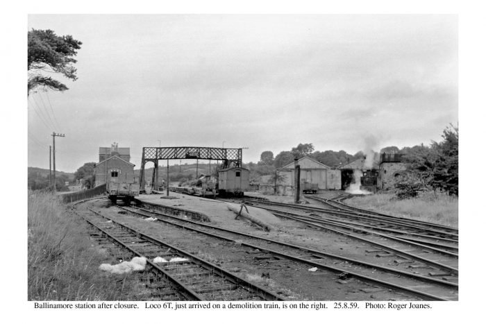 Ballinamore station after closure. The picture was taken on 25th August 1959, (c) Roger Joanes. [31]
References
- Patrick J. Flanagan; The Cavan & Leitrim Railway; Pan Books, London, 1972.
- Anthony Burges; Smoke Amidst the Drumlins – The Cavan and Leitrim in the 1950s; Colourpoint, Newtonards, County Down, 2006, 2010. (The picture in the text is of the front cover of the book and is taken from https://www.amazon.com/Smoke-Amidst-Drumlins-Leitrim-Photographers/dp/1904242626, accessed on 21st May 2019.)
- https://maps.nls.uk, accessed on 22nd May 2019.
- https://en.wikipedia.org/wiki/Mohill, accessed on 22nd May 2019.
- Suzanne Keen; Victorian Renovations of the Novel: Narrative Annexes and the Boundaries of Representation. Volume 15 of Cambridge Studies in Nineteenth-Century Literature and Culture (reprint, revised ed.). Cambridge University Press, 2005.
- Longman; Traveller’s New Guide Through Ireland, Containing a New and Accurate Description of the Roads (digitized from original in Lyon Public Library ed.); Longman, 2011 (1819).
- Irish Free State (1925); Intoxicating Liquor Commission Report (Report); Reports of Committees. The Stationery Office. https://dspace.gipe.ac.in/xmlui/handle/10973/25609, accessed on 22nd May 2019.
- https://www.railscot.co.uk/Ireland/Irish_railways.pdf, accessed on 21st May 2019.
- http://www.mohill.com, accessed on 22nd May 2019.
- http://eiretrains.com/Photo_Gallery/Railway%20Stations%20M/Mohill/IrishRailwayStations.html, accessed on 22nd May 2019.
- https://youtu.be/y2qRoLLxrnM, accessed on 22nd May 2019.
- http://homepage.eircom.net/~tina/mohill/pics/oldPhotosMohill.htm, accessed on 22nd May 2019.
- http://candlgreenway.ie, accessed on 22nd May 2019.
- http://catalogue.nli.ie/Record/vtls000303215, accessed on 23rd May 2019.
- http://catalogue.nli.ie/Record/vtls000148612, accessed on 23rd May 2019.
- https://en.wikipedia.org/wiki/Fenagh,_County_Leitrim, accessed on 24th May 2019.
- Dennis Walsh, Dennis; O’Rourke Family Genealogy and History; (1996–2010); https://rootsweb.com, accessed 24th May 2019.
- Michael A. Costello; Coleman, Ambrose; Flood, William Henry Grattan; De annatis Hiberniae: a calendar of the first fruits’ fees levied on papal appointments to benefices in Ireland A.D. 1400 to 1535; Tempest, Dundalk,1909 (PDF); https://ia800206.us.archive.org/1/items/cu31924029335464/cu31924029335464.pdf, accessed on 24th May 2019.
- http://catalogue.nli.ie/Record/vtls000303217, accessed on 24th May 2019.
- https://www.myhome.ie/residential/brochure/the-old-station-house-ardagh-fenagh-co-leitrim/3272306, accessed on 24th May 2019.
- http://www.askaboutireland.ie/learning-zone/primary-students/looking-at-places/leitrim/aspects-of-leitrim/transport/ballinamore-ballyconnell-, accessed on 24th May 2019.
- http://staging.waterwaysireland.org/SiteAssets/Corporate/Heritage%20Surveys/Shannon%20Erne%20Main%20Report%202015.pdf, accessed on 24th May 2019.
- http://www.leitrimcoco.ie/eng/Community-Culture/Library/Local-Studies, accessed on 24th May 2019.
- https://www.traffordbooks.co.uk/lot/ballinamore-railway-station-ireland-1920s/296, accessed on 24th May 2019.
- https://picclick.co.uk/Irish-Railways-Photo-Narrow-Gauge-Loco-On-233171715846.html, accessed on 24th May 2019.
- https://m.ebay.ie/itm/fg-irish-plain-back-postcard-ireland-leitrim-ballinamore-railway-station-/401499456916?_mwBanner=1&_rdt=1, accessed on 24th May 2019.
- https://www.anglocelt.ie/news/roundup/articles/2012/03/07/4009414-how-the-cavan-leitrim-railway-ran-out-of-steam, accessed on 24th May 2019.
- https://www.ebay.co.uk/itm/ki-irish-plain-back-postcard-ireland-leitrim-ballinamore-railway-station/372245087113?hash=item56ab894389:g:H3IAAOSwBOlaVWIW, accessed on 24th May 2019.
- https://chasewaterstuff.wordpress.com/2012/03/08/some-early-lines-cavan, accessed on 24th May 2019.
- https://www.worthpoint.com/worthopedia/cavan-leitrim-railway-slide-robert-427046560, accesssed on 19th May 2019.
- https://www.flickr.com/photos/110691393@N07/11387257926, accessed on 19th May 2019.

Pingback: Why did the family emigrate? – Ida Mitchell
Hi. I dont suppose you have any pictures of the small station house in Garadice near Ballinamore? or a picture of something similar please… Were they brick or stone built?…..Steve.
Hi Steve, I think you can see everything I found in the article, sorry. . Roger
Absolutely brilliant. I travelled this line several times in the 1950s. So sad that it has gone. Good luck in creating a Greenway along the route. I will certainly walk it if I am still around. I live in Colorado. However I also have a home in Leitrim between Fenagh and KeshCarrigan which I visit regularly.
Pingback: The Railway Magazine March 1959 | Roger Farnworth