Monthly Archives: Jul 2026

The Trans-Caspian Railway

The featured image for this article shows a  train of oil-tanks on the Baku-Batoum Railway, part of the original Trans-Caspian network. [31]

The original Trans-Caspian Railway is a historic, 19th-century railway built by the Russian Empire across Central Asia, stretching from Turkmenbashi (formerly Krasnovodsk) on the Caspian Sea to Tashkent, Uzbekistan. Today, it serves as the foundation for the modern Trans-Caspian International Transport Route (also known as the Middle Corridor). [1]

The station of Baharly on the Trans-Caspian Railway, circa. 1890, © Public Domain. [1]
The main routes of the original Trans-Caspian Railway, © Peter Christener and licensed for reuse under a Creative Commons licence (CC BY-SA 3.0). [1]

This article looks at the developments in the Middle Corridor which have occurred from the end of the 20th century into the 21st century. A future article (or articles) will focus on the earlier line built by the Russian Empire. …

Trans-Caspian International Transport Route (in some sources TMTM as an abbreviation (Trans-Caspian International Transport Route) or TITR (Trans-Caspian International Transport Route) is a multimodal transport corridor, which connects China with the European Union through Central Asia, Caucasus, Türkiye and Eastern Europe. [2]

The modern Middle Corridor is a vital 4,000+ kilometer multimodal trade network that connects China and Central Asia to Europe via Kazakhstan, the Caspian Sea, Azerbaijan, Georgia, and Türkiye. It consists of roughly 4,256 km of rail lines combined with 508 km of sea crossings using specialized train ferries. Cargo trains can travel from the Chinese border to Eastern Europe in about 14 to 18 days. [2]

As of 2026, 86% of the work on the project has been completed. It is planned to finish the remaining 14% of the land at the expense of funds allocated by the Government of Azerbaijan. The work already undertaken includes the refurbishment of existing lines and the construction of new sections of railway line. [2]

The Russian-Ukrainian war has limited freight transport through the Northern Corridor, so the Middle Corridor is considered a great alternative in terms of distance and duration. The Middle Corridor route is around 7,000 kilometres in length compared with 10,000 kilometres by the Northern Corridor. The alternative route is the Southern Corridor which requires good to travel around 20,000 kilometres by ship and through the Suez Canal. [2]

With the Northern Corridor closed to traffic between the EU and Asia as a result of the Ukraine-Russia conflict. The remaining possible routes are the existing Southern Corridor (predominantly by sea), the Northern Sea Route (dependent on prevailing ice conditions in the Arctic). Establishing a competitive land route not directly controlled by Russia is of great geopolitical and economic significance. [2]

Wikipedia tells us, however, that:

“Obstacles to the further use of the Middle Corridor include the limited capacities of seaports and railways, the absence of a unified tariff structure and single operator, and the alignment of geopolitics along the route. [3][4]

“Since the Russo-Ukrainian war began in February 2014, cargo traffic in the Middle Corridor has grown to nearly 3.2 million tons in 2022 as goods shifted from the Northern Corridor. Turkey positions itself as a key player between China and Europe through the Organization of Turkic States for the Middle Corridor, with cargo transportation increasing six-fold in the last decade. [5] Since 2022, China also increased its involvement in the Middle Corridor projects, signing agreements with Kazakhstan, Georgia, and Azerbaijan, [6] to develop infrastructure along the route.” [3][7]

Nigar Jafarova tells us that:

“The Middle Corridor offers a route that is at least 2,000 kilometres shorter than the Northern Corridor, which passes through Russia. This translates to reduced travel time, with the potential to shorten the journey between China and Europe to as little as 12 days, while the Northern Corridor currently takes 19 days. Most importantly, the Middle Corridor helps companies mitigate risks, uncertainties, and sanctions-compliance issues associated with transit through Russia. The development phase of the route also opens up new opportunities for B2B and B2G engagements in logistics, transportation, and infrastructure construction, as the countries strive to modernize and expand their railway systems and seaports. It also offers access to new markets, with an estimated population over 80 million along the route.” [4]

Yunis Sharifli comments that:

“Amid the ongoing crisis in the Red Sea and the Russia-Ukraine war, the Middle Corridor has emerged as a stable route for China. The Middle Corridor was officially launched in 2013 through multilateral cooperation involving Azerbaijan, Georgia, Kazakhstan, and Türkiye. Its primary aim was to enhance East-West trade connectivity and facilitate the interaction of member countries with key economic hubs such as the EU and China.

“Despite the completion of critical infrastructure projects—such as the Trans-Kazakhstan railway in 2014 and the Baku-Tbilisi-Kars (BTK) railway in 2017, which significantly strengthened the corridor’s hard infrastructure—China’s engagement with the Middle Corridor remained minimal during this period. Beijing’s perception of the Middle Corridor can be divided into two phases: the first from 2013 to 2022, and the second from 2022 to the present.” [7]

Between 2013 and 2022, China’s limited involvement in the Middle Corridor could be attributed to a combination of political, security, economic, and technical factors. Politically, the Middle Corridor emerged as an alternative yet complementary route to the Northern Corridor through Russia, but China’s deepening relations with Russia post-2014 made proactive engagement with the Middle Corridor potentially risky for the Chinese.

The Chinese position was further influenced by a number of different factors:

  • the EU’s preference for using the Northern Corridor for trade with China – before 2022, around 90% of EU-China land-based trade passed through the Northern Corridor via Russia. [8]
  • Security concerns and economic factors. The volatile situation in the Nagorno-Karabakh region, marked by a fragile ceasefire between Azerbaijan and Armenia.
  • Despite the development of critical infrastructure the cost of using the Middle Corridor remained significantly higher than the cost of using the Northern Corridor. Sending cargo through the Middle Corridor cost between US$3,500 and US$4,500 per forty-foot equivalent unit (FEU), [9] with some estimates reaching US$5,000 per twenty-foot equivalent unit for the Urumqi-Aktau-Baku-Poti-Constanta-Burgas-EU route. [10] Contrast this with the Northern Corridor costs of between  US$2,800 to US$3,200 per FEU. [9]
  • Technical challenges – the Northern Corridor did not require transhipment and minimised border crossings but the Middle Corridor was (and still is) a multi-modal transport route involving both land and sea travel. This complexity inherently increases cargo transit times and complicates logistics.
  • Hard infrastructure issues – congestion at Caspian and Black Sea ports caused significant delays, introducing uncertainty in cargo arrival times. The imbalance between rail capacities and insufficient ferry and port services on both sides of the Caspian Sea exacerbated traffic issues and delays. [11]
  • Soft infrastructure deficiencies – the lack of unified regulations, technical standards, and digitalization resulted in unpredictable transit times and extended waiting periods at checkpoints. The absence of coordinated tariffs for pricing increased transportation costs and made it difficult for freight forwarders to plan budgets effectively. [12]

The geopolitical shifts that unfolded after 2022 significantly elevated the strategic importance of the Middle Corridor for China. The disruption of global supply chains, primarily due to international conflicts, coupled with the growing significance of the Middle Corridor for land-based trade between the EU and China, prompted Beijing to adopt a more proactive approach in its engagement with countries along this route.

Bilateral agreements were negotiated by China with Kazakhstan (2023), Georgia (2024), and Azerbaijan (2024).

Sharifli continues:

“In addition to strengthening bilateral relations, Beijing has also expanded its engagement at a multilateral level. Notably, China’s formal involvement in the Middle Corridor Multimodal Joint Venture established by Kazakhstan, Azerbaijan and Georgia through the China Railway Container Transport Corporation (CRTC) signals Beijing’s intention to diversify its transport routes and mitigate geopolitical risks. [13]

“China’s efforts go beyond agreements and statements, encompassing tangible projects to boost the corridor’s development. A significant example is Georgia’s announcement that a Chinese group is the sole bidder for constructing a large deep-sea port in Anaklia on the Black Sea coast.”[7]

Sharifli also highlights:

  • The agreement between China and Kazakhstan to build the Tacheng-Ayagoz railway line and establish a third railway checkpoint between the two countries. “This new railway line is expected to increase annual rail freight capacity between China and Kazakhstan from 28 million tons to approximately 48 million tons. The new checkpoint will also ease pressure on the Dostyk-Alashankou and Altynkol-Khorgos crossings, reducing transit times in the long term. Additionally, Kazakhstan Temir Zholy and Lianyungang Port Group agreed to jointly invest in a container hub at the port of Aktau on Kazakhstan’s Caspian coast, which will boost the port’s handling capacity and further alleviate congestion.” [14][15][16]
  • Geopolitical developments – Sanctions imposed on Russia following the Russia-Ukraine war have led to the exit of EU companies from Russia and made transportation via the Northern Corridor more challenging. Restrictions on insurance for shipments, sanctions on Russia’s banking sector, and growing uncertainty in Russia’s domestic policy have further deterred foreign companies from using this route.
  • The Middle Corridor attracted the attention of major global shipping companies such as MSC (Italian-Swiss), Maersk (Denmark), CMA CGM (France), COSCO (China), and ZIM (Israel). These companies are launching new services along the Middle Corridor, primarily through Georgia’s port of Poti. [17]
  • Disruptions in traditional maritime routes caused by Houthi attacks on both commercial and military ships in the Red Sea have further complicated global shipping for Chinese companies. These disruptions have forced about 90% of the usual container capacity transiting through the Red Sea and Suez Canal to be rerouted around the Cape of Good Hope, South Africa, adding up to 10 extra days of transit time for shipments from East Asia to Europe. [18]
  • Against the backdrop of sanctions on countries like Iran and Russia, along with disruptions in both the Northern and maritime routes, the Middle Corridor has emerged as the most stable and reliable route for China and its companies. Consequently, transportation volume via the Middle Corridor surged from 784,000 tons to 2,764,000 tons in 2023. [19]
  • “The resolution of the Nagorno-Karabakh conflict has also contributed to a more stable environment in the South Caucasus, enhancing the security and reliability of the Middle Corridor for Chinese companies. Ongoing peace talks between Armenia and Azerbaijan are expected to promote long-term regional stability, further solidifying the corridor’s importance.” [7]
  • Reduction in the cost of shipping via the Middle Corridor – tariff rates for transporting cargo via the Middle Corridor have dropped from US$4,500 per FEU in 2020 to a range of US$2,500 to US$3,250 in 2024. [20][21]
  • Regional active investments in both hard and soft infrastructure have enabled the optimization of the Middle Corridor. Sharifli notes: the 2024 completion of the BTK railway modernization, which has increased its handling capacity from 1 to 5 million tons of cargo per year; [22] the joint investment by Kazakhstan and Georgia in a new multimodal terminal at the Port of Poti, boosting its capacity to 450,000 TEUs annually; [23] the establishment of the Middle Corridor Multimodal Joint Venture by Azerbaijan, Kazakhstan, and Georgia. [7][24]
  • the increasing involvement of Western countries in the development of the corridor – for example, the European Bank for Reconstruction and Development (EBRD) announced a US$103.7 million investment in Kazakhstan Temir Zholy’s bond issuance, aimed at strengthening the nation’s railway operator’s financial and operational resilience while modernizing alternative freight routes between Asia and Europe. [25]

Sharifli concludes:

“China’s evolving approach to the Middle Corridor represents a strategic shift in its Eurasian policy, driven by recent global events and changing geopolitical dynamics. The COVID-19 pandemic, the ‘Ever Given’ [26] crisis in the Suez Canal, and ongoing disruptions in the Northern Corridor and the Red Sea have underscored the risks of relying on single trade routes. In response, China has intensified its engagement with the Middle Corridor, viewing it as a stable alternative for sustainable trade with the EU. This route not only connects China to Northern and Southern European markets but also provides access to the Middle East through Türkiye. By diversifying its trade options, China aims to mitigate geopolitical risks and enhance its economic resilience in an increasingly unpredictable global landscape.

“Moreover, China’s active involvement in the Middle Corridor serves multiple strategic objectives beyond mere trade diversification. It allows Beijing to expand its economic influence across Central Asia and the Caucasus while delicately balancing its relationship with Russia. By investing in the corridor, China is helping regional countries reduce their dependence on Russian routes—a significant factor given that 80% of Uzbekistan’s trade and a large portion of Kazakhstan’s oil exports currently pass through Russian territory. This strategy not only strengthens China’s economic leverage in the region but also positions it to play a more influential role in shaping Eurasian connectivity. However, the success of this approach depends on overcoming challenges such as infrastructure development, maintaining regional stability, and ensuring the route’s economic viability. As the Middle Corridor develops, it has the potential to redraw the economic and geopolitical map of Eurasia, with far-reaching implications for global trade patterns and regional power dynamics.” [27]

But …

But, and perhaps this is a very significant proviso: …

The Much-Touted Middle Corridor Transport Route Could Prove a Dead End!

Friedrich Conradi wrote on 29th April 2026 in an online article for Carnegie Politika, [29][30] that:

“In the wake of Russia’s full-scale invasion of Ukraine and the most recent wars in the Middle East, experts and politicians expected a major transport route to emerge through Central Asia and the South Caucasus, bypassing sanctioned Russian and Iranian territory: the so-called Middle Corridor. For the EU and United States, the corridor holds dual promise: as a trade link between China and Europe and as a strategic pathway for Central Asia’s vast reserves of critical minerals, which are essential for the energy transition and defense industries.

“In 2025, the planned ‘Trump’ Route for International Peace and Prosperity (TRIPP) through Azerbaijan and Armenia further established the Middle Corridor as a widely discussed alternative to transit through Russia. But obstructive governance, persistent infrastructure gaps, climate change, and geopolitical risk stand in the corridor’s way and may impose a time horizon on its viability. Accordingly, for Central Asian states, the Middle Corridor offers not a permanent pathway to European markets, but a window of opportunity that should be leveraged strategically.

“The Middle Corridor, or the Trans-Caspian International Transport Route (TITR), is a 4,000 kilometre multimodal transport network linking western China to Eastern Europe via Central Asia, the Caspian Sea, the South Caucasus, the Black Sea, and Türkiye. In 2024, cargo volume along the Middle Corridor across the Caspian Sea increased by more than 63 percent year on year, reaching 4.1 million tons (compared with 500,000 tons before Russia’s full-scale invasion). The increased throughput of Georgia’s biggest ports, Poti and Batumi, suggests this trend continued in 2025, as the full data are not available yet.

“Historically dominated by energy products, the corridor is shifting toward containerized traffic and is increasingly promoted as a future route for Central Asia’s mineral wealth, including uranium, copper, tungsten, and titanium. For the region’s landlocked states, the Middle Corridor represents an opportunity to reduce export dependence on China by diversifying toward EU and U.S. markets. For the EU, it is a flagship project of the Global Gateway strategy, envisioned as an alternative route to diversify critical mineral and energy supply chains while reinforcing strategic autonomy and de-risking from Russian transit.

“But impressive growth rates obscure a sobering reality: the Middle Corridor remains far from competitive. It only handles about 6 percent of the Northern (Russian) Corridor’s annual capacity of 100 million tons, and while many in the West expect the Middle Corridor’s continued growth, several indicators point in the opposite direction.” [29]

Conradi points out that until the proposed TRIPP corridor becomes operational, Georgia will remain the Middle Corridor’s sole gateway to Europe. But Georgia has just cut its 2026 support for the new port at Anaklia by 66% (from 150 million lari ($56 million) to 50 million lari). Tbilisi seems uninterested in building the new port. It also seems unwilling to meaningfully expand the ports of Poti or Batumi.

Why? Perhaps lack of confidence in growth forecasts? Perhaps pressure from Russia intended to prevent the Middle Corridor replacing its Northern Corridor? Perhaps China is relatively disinterested in the completion of the new port?

Whatever the cause, the Middle Corridor’s critical infrastructure remains stalled. As a result the USA has been seeking to establish the TRIPP route through Armenia.

Conradi points out that “bypassing Georgia may mean trading one set of risks for another. Iran’s demonstrated willingness to escalate horizontally by destroying nearby infrastructure it deems tied to Western powers renders the TRIPP route through southern Armenia (27 miles from the Iranian border) contingent on a regional stability that cannot be assumed.” [29]

In short, the South Caucasus, offers no easy route east or west. “Georgia is paralyzed by political dysfunction and stalled infrastructure. Armenia offers a potential alternative, but one shadowed by Iranian volatility. For the Middle Corridor to fulfill its promises, one of these routes must become scalable. At present, neither is.” [29]

A very different matter is the drying up of the Caspian Sea. Russia has dammed and regulated the Volga River which provides about 80 percent of the sea’s inflow. Rising global temperatures are intensifying evaporation and accelerating desertification in the region. States around the Caspian sea are increasingly  turning to Caspian desalination for civilian purposes. The net result has been an annual average drop in water level of 30 centimetres.

Conradi says that the drop in water levels is “already affecting operations, having reduced rail tank car ferry transport by 22 percent and wagon transport by 10 percent on the Baku–Kuryk route, according to the Azerbaijan Caspian Shipping Company. … Should this trend continue, Kazakhstan’s ports of Aktau and Kuryk could face a critical threshold: a projected sea level drop of up to 6.5 metres could leave current berths landlocked by 2045, potentially forcing a transition from shoreline operations to offshore deep-water terminals and constant multimillion-dollar dredging to remain functional.” [29]

As Conradi says, “the Middle Corridor has hard bottlenecks and likely a limited shelf life.” [29] Perhaps the most critical question is whether there is sufficient commitment from the various countries involved to sustain a converted effort to secure a second functioning east-west land-based corridor that can effectively compete with the Northern Corridor controlled by Russia.

References and Notes

  1. https://en.wikipedia.org/wiki/Trans-Caspian_railway, accessed on 10th July 2026.
  2. https://www.unescap.org/sites/default/d8files/event-documents/1.%20Azerbaijan.pdf, accessed on 10th July 2026.
  3. https://en.wikipedia.org/wiki/Trans-Caspian_International_Transport_Route, accessed on 10th July 2026.
  4. Nigar Jafarova; The rise of the Middle Corridor; FrontierView, 25th May 2023; via https://frontierview.com/insights/the-rise-of-the-middle-corridor, accessed on 10th July 2026.
  5. Sagar K. Chourasia; The rise of the Middle Corridor: What is India’s response? ; Observer Research Foundation, 17th June 2023; via https://www.orfonline.org/expert-speak/the-rise-of-the-middle-corridor, accessed on 10th July 2026.
  6. Robert M. Cutler; How Kazakhstan and Azerbaijan Are Rewiring the Middle Corridor; The Times of Central Asia, 3rd April 2025; via https://timesca.com/how-kazakhstan-and-azerbaijan-are-rewiring-the-middle-corridor, accessed on 10th July 2026.
  7. Younis Sharifli; From Disinterest to Strategic Priority: China’s Changing Approach to the Middle Corridor; Trends, 24 November 2024; via https://trendsgroup.org/insight/from-disinterest-to-strategic-priority-chinas-changing-approach-to-the-middle-corridor, accessed on 10th July 2026.
  8. Eurasian Development Bank; The Eurasian Transport Network; 2024,  https://eabr.org/en/analytics/special-reports/the-eurasian-transport-network, accessed on 10th July 2026.
  9. Organization for Economic Co-operation and Development (OECD); Realising the Potential of the Middle Corridor; 2023; via https://www.oecd.org/en/publications/2023/12/realising-the-potential-of-the-middle-corridor_c458041c.html,accessed on 10th July 2026.
  10. Evgeny Vinokurov & Taras Tsukarev; The Belt and Road Initiative and the transit countries: an economic assessment of land transport corridors; Area Development and Policy 3, No. 1, 2017, p93–113, via https://doi.org/10.1080/23792949.2017.1385406, accessed on 10th July 2026.
  11. Jakub Jakóbowski, Konrad Popławski, and Marcin Kaczmarski; The Silk Railroad: The EU-China rail connections: background, actors, interests; Centre for Eastern Studies, 28th February 2018; via https://www.osw.waw.pl/en/publikacje/osw-studies/2018-02-28/silk-railroad, accessed on 10th July 2026.
  12. Yunis Sharifli; Optimization Efforts to Improve Transit Through the Critical Middle Corridor; The Jamestown Foundation, 4th August 2022; via https://jamestown.org/program/optimization-efforts-to-improve-transit-through-the-critical-middle-corridor, accessed on 10th July 2026.
  13. Kazakhstan and China Collaborate on Container Hub for Aktau Port; The Times of Central Asia, 3rd July 2024; via https://timesca.com/kazakhstan-and-china-collaborate-on-container-hub-for-aktau-port, accessed on 20th July 2026.
  14. Kazakhstan, China set to start building Ayagoz-Tacheng railroad; Interfax, 17th October 2023; via https://interfax.com/newsroom/top-stories/95559, accessed on 10th July 2026.
  15. Kazakhstan launches construction of new rail link to China; New Silkroad Discovery, 29th December 2023, https://www.newsilkroaddiscovery.com/kazakhstan-launches-construction-of-new-rail-link-to-china, accessed on 10th July 2026.
  16. Kazakhstan and China to Build Container Hub in the Port of Aktau; The Times of Central Asia, 23rd September 2024; via https://timesca.com/kazakhstan-and-china-to-build-container-hub-in-the-port-of-aktau, accessed on 10th July 2026.
  17. Konrad Popławski, Sandra Baniak, Adam Michalski, & Marcin Popławski; The Middle Corridor: A Eurasian alternative to Russia;  Centre for Eastern Studies, 26th January 2024,; via https://www.osw.waw.pl/en/publikacje/osw-report/2024-01-26/middle-corridor, accessed on 20th July 2026.
  18. Hunter Stoll; The Middle Corridor: A Renaissance in Global Commerce; The Diplomat, 11th March 2024, https://thediplomat.com/2024/03/the-middle-corridor-a-renaissance-in-global-commerce, accessed on 10th July 2026.
  19. Trans-Caspian International Transport Route; Transportation volume via TITR, thousand tons; via https://middlecorridor.com/en, accessed on 10th July 2026.
  20. Trans-Caspian International Transport Route; EY, 15th April 2024; via https://www.ey.com/en_kz/strategy-transactions/trans-caspian-international-transport-route, accessed on 10th July 2026.
  21. Eurasian Rail Alliance Index; ERAI Eurasian Rail Alliance Index; via https://index1520.com/en, accessed on 10th July 2026.
  22. Trans-Caspian International Transport Route; Modernization work of the Baku-Tbilisi-Kars (BTK) railway line has been completed;  6th May 2024, https://middlecorridor.com/en/for-clients/info-clients/modernization-work-of-the-baku-tbilisi-kars-btk-railway-line-has-been-completed, accessed on 19th July 2026
  23. New multimodal terminal in Poti starts construction; RailFreight.com, 14th August 2023, https://www.railfreight.com/intermodal/2023/08/14/new-multimodal-terminal-in-port-of-poti-starts-construction, accessed on 10th July 2026.
  24. Azerbaijan, Georgia, Kazakhstan Create Joint Venture to Develop Middle Corridor’s Multimodal Service; The Astana Times, 27th October 2023; via https://astanatimes.com/2023/10/azerbaijan-georgia-kazakhstan-create-joint-venture-to-develop-middle-corridors-multimodal-service, accessed on 10th July 2026.
  25. EBRD Invests in Kazakhstan Railway Bonds to Upgrade Alternative Freight Route Between Asia and Europe; The Astana Times, 25th July 2022; via https://astanatimes.com/2022/07/ebrd-invests-in-kazakhstan-railway-bonds-to-upgrade-alternative-freight-route-between-asia-and-europe, accessed on 10th July 2026.
  26. The Suez Canal was blocked for six days from 23rd to 29th March 2021 by the ‘Ever Given’, a container ship that had run aground in the canal. The 400-metre-long (1,300 ft), 224,000-ton, 20,000 TEU vessel was buffeted by strong winds on the morning of 23rd March, and ended up wedged across the waterway with its bow and stern stuck on opposite canal banks, blocking all traffic until it could be freed. Egyptian authorities said that “technical or human errors” may have also been involved. The obstruction occurred south of the two-channel section of the canal, so other ships could not pass. The Suez Canal Authority (SCA) hired Royal Boskalis through its subsidiary Smit International to manage marine salvage operations. The blockage of one of the world’s busiest trade routes slowed trade between Europe, Asia, and the Middle East, tying up goods worth an estimated US$9.6 billion per day.  By 28th March, at least 369 ships were queuing to pass through the canal. [28]
  27. Yunis Sharifli; China’s Dominance in Central Asia: Myth or Reality?; Royal United Service Institute, 18th January 2023; via https://rusi.org/explore-our-research/publications/commentary/chinas-dominance-central-asia-myth-or-reality, accessed on 10th July 2026.
  28. https://en.wikipedia.org/wiki/2021_Suez_Canal_obstruction, accessed on 10th July 2026.
  29. https://carnegieendowment.org/russia-eurasia/politika/2026/04/middle-corridor-transport-prospect, accessed on 10th July 2026.
  30. Carnegie Politika is a digital publication that features unmatched analysis and insight on Russia, Ukraine and the wider region. For nearly a decade, Carnegie Politika has published contributions from members of Carnegie’s global network of scholars and well-known outside contributors and has helped drive important strategic conversations and policy debates.
  31. https://www.railwaywondersoftheworld.com/trans_caspian_railway.html, accessed on 10th July 2026.
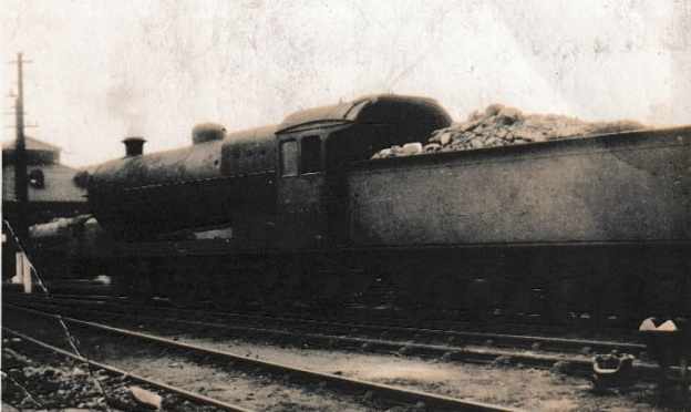
Ex-Lancashire & Yorkshire Railway (L&YR) 0-8-0 Locomotive in LMS Days at Liverpool, Bank Hall Locomotive Shed – 1937

The featured image for this short article is a relatively poor/grainy photograph taken on Sunday 25th July 1937 at Liverpool Bank Hall Engine Shed. Prominent in the photograph and identified by the photographer, is ex-L&YR 0-8-0 7F Locomotive No. 12981. In the background LMS 4-6-0 No. 5229 can be glimpsed. [Unknown Photographer]

In June 2026, I was given an image printed on a postcard in 1937. The photograph was taken at Liverpool Bank Hall Engine Shed (Code 27A) which was in north Liverpool, located just off Stanley Road in Kirkdale/Bootle. This is a ‘down-the-rabbit-hole’ kind of article in which I follow my nose from the photograph above and see where that leads. ….

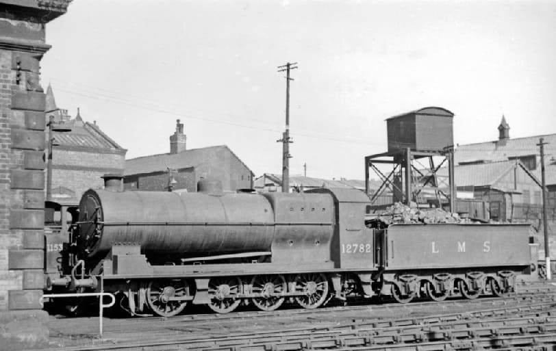
Also seen at Liverpool Bank Hall Locomotive Shed (27A) was No. 12782, another ex-L&YR 0-8-0 locomotive. No. 12782 is one of the survivors of a once numerous class of L&Y Aspinall Class 30 0-8-0 6Fs dating from 1901. It was withdrawn in 9/50, almost the last of its Class. Note the most obvious difference from No. 12981, the cab. This photograph was taken on 20th June 1948, (c) Ben Brooksbank and licenced for reuse under a Creative Commons Attribution Share-alike license 2.0 (CC BY-SA 2.0). [1]
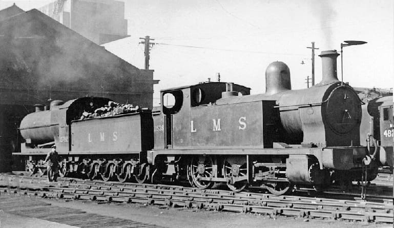
Another view of Locomotive No. 12782 at Bank Hall. On the same road is ex-L&Y 1F 0-6-0T LMS No. 11535, fitted with dumb buffers and swinging spark-arrestor for working in the Docks, (c) Ben Brooksbank and licenced for reuse under a Creative Commons Attribution Share-alike license 2.0 (CC BY-SA 2.0). [2]

Bank Hall Shed was and L&YR shed which was later operated by the LMS and later British Railways, it housed L&YR ‘Pug’ 0-4-0Ts for dock shunting, Class 02 shunters like D2852, and Stanier Class 5s for Liverpool Exchange passenger services.

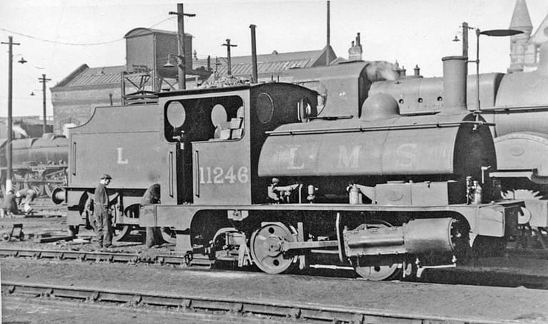
Ex L&YR ‘Pug’ 0-4-0T locomotive – LMS No. 11246 at Liverpool Bank Hall Locomotive Shed on 20th June 1948, (c) Ben Brooksbank and licenced for reuse under a Creative Commons Attribution Share-alike license 2.0 (CC BY-SA 2.0). [3]

Records available online give details of the locomotives on Bank Hall Shed on Sunday 7th March 1937, Sunday 27th February 1938 and Sunday 7th September 1941 do not show No. 12981 as being on shed. This is not conclusive evidence that No. 12981 was not allocated to Bank Hall as it may, in each case, have been out on duty. However, No. 12981 is recorded as being on shed on Saturday 3rd October 1942. [4]

No. 12981 was one of a number of L&YR 0-8-0 locomotives transferred to the LMS at the grouping. L&YR Class 30 locomotives were classified by the LMS as 6F locomotives there are a couple of images of one of these locomotives above. No. 12981 was a L&YR Class 31 locomotive. This class were given a power-rating of 7F by the LMS. “The class was designed by George Hughes and introduced in 1912. The class comprised 115 new locomotives (the 1546 Class, built 1912–21) and 40 rebuilt from two other classes: the 91 Class (built 1900–08) and the 9 Class (built 1918).” [5][6][7][8]

A LMS (ex-L&YR) 7F 0-8-0 at Normanton Shed in 1947. This is No. 12928, built by Hughes c. 1920, withdrawn in September 1947 – soon after this photograph was taken. Note the style of cab on this locomotive matches the cabs on the Class 30 locomotives. (c) Ben Brooksbank and licenced for reuse under a Creative Commons Attribution Share-alike license 2.0 (CC BY-SA 2.0). [9]

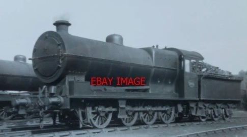
This image was for sale on eBay. It shows the same cab as the featured image for this article above. The vendor describes the locomotive as LMS ex-L&YR Class 91 Loco. No. 1440 (LMS 12981). It appears that No. 12981 was a locomotive rebuilt at Horwich from a Class 91 Locomotive built between 1900 and 1908. [10]

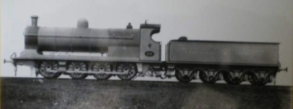
This is also a Class 91 0-8-0 – it has the same cab as the Class 30 locomotives. [11]

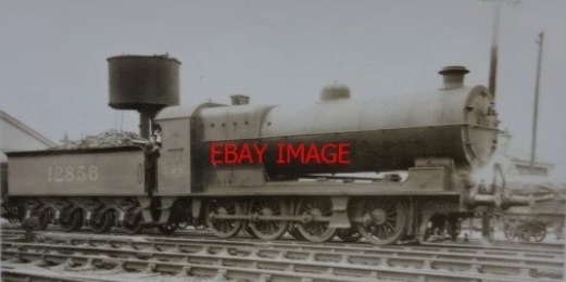
Another image for sale on eBay shows another Class 31 – No. 12856. This has the same cab detail as the Class 30 locomotives. [12]

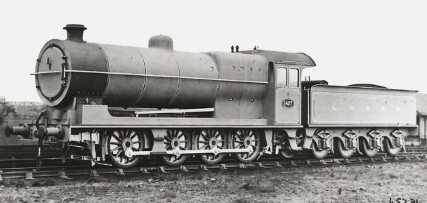
An ex-works photograph of L&YR locomotive No. 1427 which was one of the L&YR’s Class 91 locomotives. It became No. 12990 in LMS days. Note that the cab is the same as No. 12981. Given that this is an ex-works image, it is clear that this batch of locomotives were given a different of cab compared with their cousins. [13]

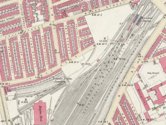
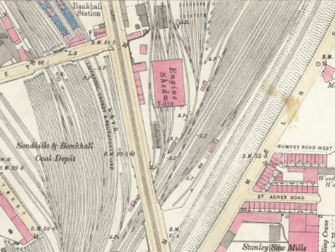
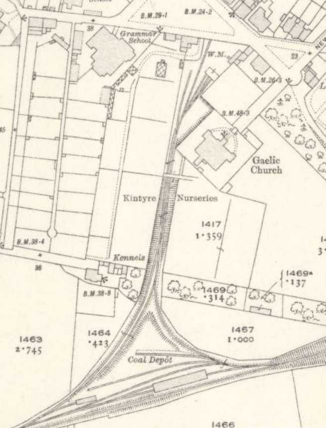
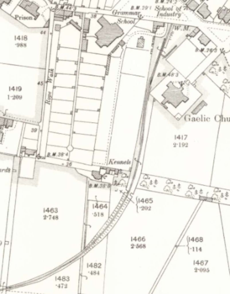
Bank Hall Locomotive Shed was situated off Stanley Road close to the Kirkdale tunnels. The depot was opened in 1865 and closed in 1966. At the time of closure it had two sheds – a brick-built 8-road dead-ended shed and a brick built shed with 4 through roads and 4 dead-end roads. The next two map extracts are taken from the 1st Edition 25″ Ordnance Survey. Two sheets cover the area of the Bank Hall Sheds. The locomotive depot sat to the East of the Liverpool, Crosby and Southport line and Northwest of North Docks Branch (through Kirkdale Railway Station) which were in turn alongside the Cheshire Lines Railway.

One of the two sheds at Bank Hall Locomotive Depot can be seen at the bottom left of this map extract. Immediately North of the shed is Atlantic Docks Junction (LNWR) which was established on 5th September 1881 It was the point at which the Alexandra Dock branch diverted from the original Bootle branch just east of the Canada Dock Tunnel. Stanley Road is at the bottom left of the extract, with tram lines heading North and South along it. A tramway depot is just to the North of this map extract. Northeast of Kirkdale Station which sits in the top right of this map extract. The North Docks Branch (L&YR) and the Cheshire Lines Railway (CLC) enter Kirkdale tunnels and underground separate with the CLC lines heading Northeast towards Walton-on-the-Hill Railway Station. Two turntables can be seen within the curtilage of locomotive depot. [14]
The second of the two engine sheds can be see centre-top of this map extract. Bankhall station can be seen top-left with the Liverpool, Crosby and Southport line curving away to the Northwest. The 4 through roads sit on the west side of the shed. the four dead-end roads enter from the North end of the shed. A multiplicity of marshalling sidings sit to the East of the depot. Stanley Road with its tramway are to the West of the locomotive sheds. [15]

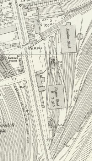
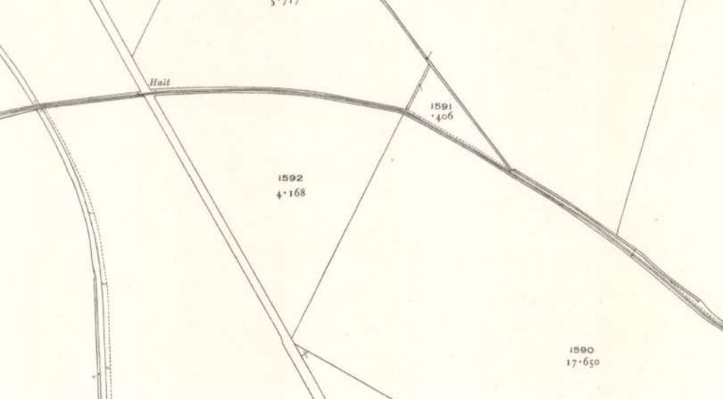
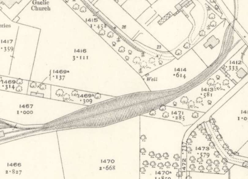
This map extract shows the depot in 1906. The OS Sheet was surveyed in 1906 and published in 1908. There are no obvious differences from the map extracts above. The next edition of the OS mapping of 1924/25 shows no further change from this map extract. [16]

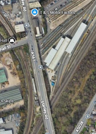
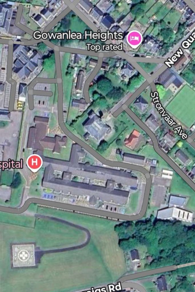
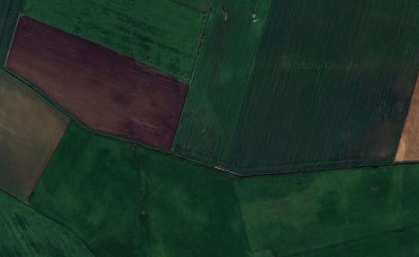
The same location in the 21st century. The site is occupied by Kirkdale Traction Maintenance Depot. It is home to Mersey Rail’s 777 fleet of trains and the engineers workshop for the old 507/8s. [Google Maps, July 2026]

In 1903, the Mersey Railway was electrified; this was the world’s first full electrification of a steam railway. It was followed by the electrification of the Lancashire and Yorkshire Railway line from the Liverpool Exchange railway station to Southport railway station three years later. In 1937, electrification of the Wirral Railway lines to New Brighton railway station and West Kirby railway station enabled service into Liverpool via the Mersey Railway Tunnel. Bank Hall continued to serve and stable steam locomotives, by the 1937, it had one of the large reinforced concrete coaling stages. Shed Bash UK provides details of locomotives stabled/allocated to Bank Hall MPD in the period from 1937 to 1966 when it closed. [4]

Memories of Bank Hall Sheds (27A) in the period 1960-1966 can be found here. [17]

After 1966, with Bank Hall MPD closed remaining steam-powered services were supported from elsewhere and 1968 waw the last of regular steam use in the country.

Between 1966 and 1980, the Mersey Railway became part of the Merseyrail network which was radically transformed from a fragmented group of suburban lines into a unified, metro-style urban transit system. This era saw the introduction of the Merseyrail brand, the construction of the underground city centre tunnels, and the replacement of aging pre-war rolling stock with modern electric trains. Merseyrail made use of the older Class 502 EMU units until 1980.

The British Rail Class 502 was a n EMU originally built by the LMS at its Derby Works. Introduced in 1940 and withdrawn by 1980, they spent the whole of their working lives on the electrified railway lines north of Liverpool. Their original livery was LMS maroon. [20]

In the 21st century, modern traction on Mersey Rail includes the older Class 507/8 EMUs and the more modern Class 777 EMUs. These are maintained on the site of the old MPD at Bank Hall.

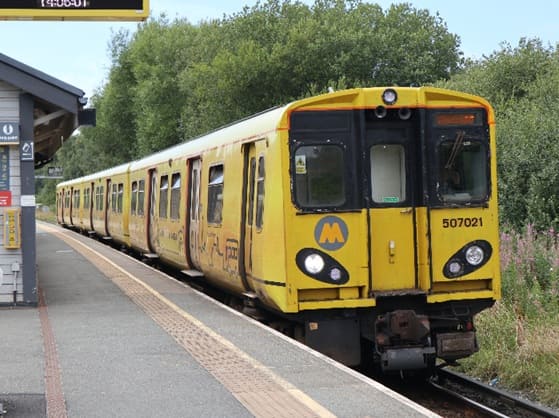
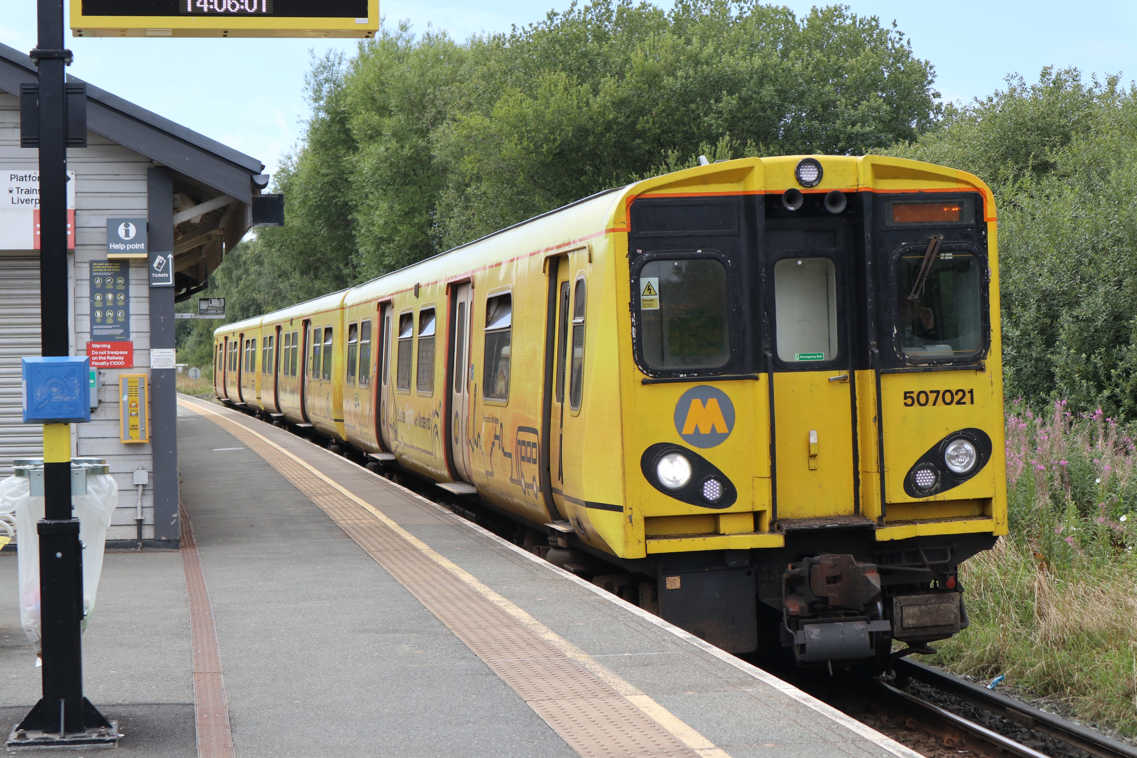
The British Rail Class 507 electric multiple unit (EMU) passenger trains were built by British Rail Engineering Limited at Holgate Road carriage works in two batches from 1978 to 1980. They are a variant of British Rail’s standard 1972 design for suburban EMUs which eventually encompassed 755 vehicles over five classes (Class 313, 314, 315, 507 and 508), (c) Vanmanyo and licensed for reuse under a Creative Commons licence (CC BY-SA 4.0). [18]

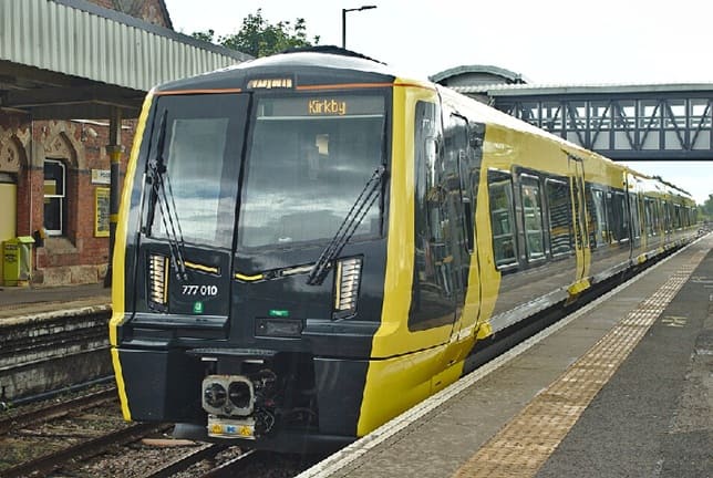
The British Rail Class 777 METRO is a class of electric multiple unit passenger trains delivered by the Swiss rolling stock manufacturer Stadler Rail, being used on the Merseyrail network, (c) Rodhullandemu (2021) and licensed for reuse under a Creative Commons licence (CC BY-SA 4.0). [19]

References

  1. https://www.geograph.org.uk/photo/2606508, accessed on 7th July 2026.
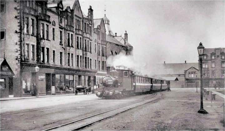
  2. https://www.geograph.org.uk/photo/2217586, accessed on 7th July 2026.
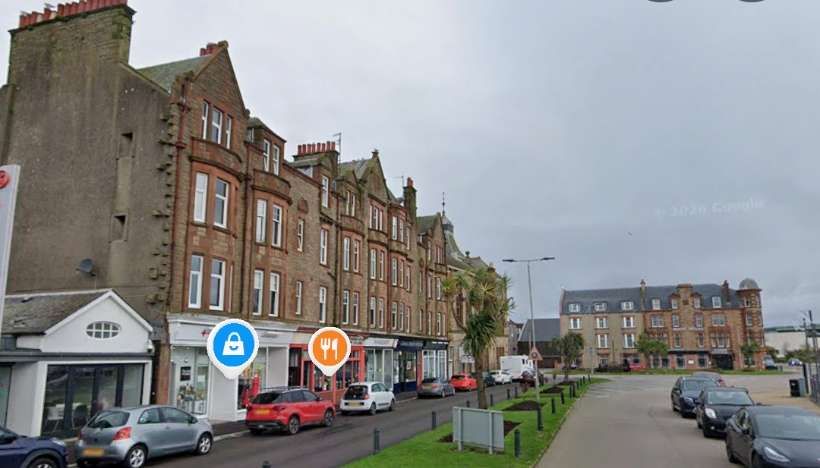
  3. https://www.geograph.org.uk/photo/2224499, accessed on 7th July 2026.
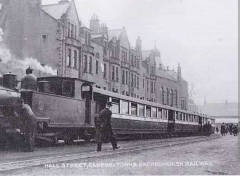
  4. https://shedbashuk.blogspot.com/2013/01/bank-hall-1954-1964.html, accessed on 7th July 2026.
  5. https://en.wikipedia.org/wiki/L%26YR_Class_31, accessed on 7th July 2026.
  6. H. C. Casserley & S. W. Johnston; Locomotives at the Grouping, No.3, LMS; Ian Allan, Shepperton, 1966, p130.
  7. John Marshall; The Lancashire & Yorkshire Railway, Volume 3; David & Charles, Newton Abbot, 1972 p186–8, p260–2, p266, p267–9.
  8. Eric Mason; The Lancashire and Yorkshire Railway in the Twentieth Century; Ian Allan, Shepperton: 1975 [1954], p147–9, p152–6.
  9. https://www.geograph.org.uk/photo/2785803, accessed on 7th July 2026.
  10. https://www.ebay.co.uk/itm/362614969179, accessed on 7th July 2026.
  11. https://www.ebay.co.uk/itm/192886948146, accessed on 7th July 2026.
  12. https://www.ebay.co.uk/itm/362613433191, accessed on 7th July 2026.
  13. https://www.ebay.co.uk/itm/334283762825, accessed on 7th July 2026.
  14. https://maps.nls.uk/view/126523040, accessed on 7th July 2026.
  15. https://maps.nls.uk/view/126523070, accessed on 7th July 2026.
  16. https://maps.nls.uk/geo/explore/#zoom=17.0&lat=53.43776&lon=-2.98547&layers=168&b=ESRIWorld&o=100, accessed on 8th July 2026.
  17. https://www.derbysulzers.com/birkenhead.html, accessed on 8th July 2026.
  18. https://upload.wikimedia.org/wikipedia/commons/9/9d/507021_Bidston.jpg, accessed on 8th July 2026.
  19. https://commons.wikimedia.org/wiki/File:777010_at_Hooton_Station_20210728-1.jpg, accessed on 8th July 2026.
  20. https://en.wikipedia.org/wiki/British_Rail_Class_502#/media/File:Sandhills_1979001_1.jpg, accessed on 8th July 2026.
The Thinking About Light Railways before 1896 (and the 1896 Act of Parliament in the UK).

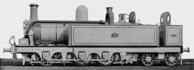
The featured image for this article shows a brand new standard-gauge locomotive – 0-6-4T Mersey Railway No. 1 ‘The Major’. It had not yet received its nameplates when it posed in ‘works grey’ at the Beyer, Peacock works at Manchester in 1885. The locomotive served on the Mersey Railway until that line decided on electrification. Four engines from the line, including ‘The Major’ found employment in Australia, on John Brown’s private light railway – the Richmond Vale Railway in New South Wales. The image comes from “Light Railways – Australia’s Magazine Industrial and Narrow Gauge Railways.” It is included here as an example of a standard gauge locomotive employed on an industrial line recognised as a light railway by ‘The Light Railway Research Society of Australia’. Not all ‘Light railways’ were narrow gauge, nor were their locomotives small 0-4-0T or 0-6-0T locomotives. [7]

W.J.K. Davies tells us that in the 1870s, it became apparent both in the UK and other countries that “many districts, while they would benefit immensely from the facilities afforded by a railway, just could not maintain a line built and operated to main line standards. And so, gradually, during the 1870’s and 1880’s, the concept of the light railway was formulated; a sub-standard means of bringing the advantages of rail transport into rural districts with the deliberate intention of opening them up and improving them. It must be made clear that this concept was different both from the idea of a standard gauge branch line which, although single track, was built and equipped in such things as signalling, stock and staffing to the same standards as the main lines, and from those narrow gauge lines already in existence which had been constructed in difficult country for a specialized purpose, normally the carriage of minerals; the best example of which was the Ffestiniog Railway, in Wales. These lines were not light railways in the true sense of the term.” [1: p24]

The true light railway developed first beyond the confines of the UK, “while at home even the minor railways, both standard and narrow gauge, were still largely restricted by custom which demanded such things as raised station platforms, separate goods yards and elaborate signalling arrangements; and by Board of Trade regulations framed for more ambitious projects. Even abroad, ideas developed in various ways in different countries, usually by trial and error methods, and it was not until the 1890’s, when the International Railway Congress debated the situation at several of their annual conferences, that anything resembling a clear picture of what constituted a light railway emerged.” [1: p24-25]

The term, as might be expected, proved difficult to define, for what was a light railway in one country, might be considered main line in another; it might be of standard or narrow gauge depending on the circumstances. In Britain, a light railway usually meant a light branch line of an average length of about ten miles, while on the other hand, in France, metre gauge lines substantially built with considerable engineering works and often fifty miles or more in length were also classed as light railways as indeed they were in comparison with the cost of building and maintaining a standard gauge line in the same circumstances. Perhaps the best definition is that a light railway is a line of railway constructed deliberately below the standard of a country’s main line railways for the sake of economy in construction and working and intended to open up a poor district, at the same time producing additional traffic for the main lines. It must, if it is to obtain all the advantages of being a light railway, be freed from many restrictions imposed on main lines for safety reasons, such as elaborate signalling, manning of level crossings, etc. It must be able to throw off sidings at convenient points and even perhaps have portable tracks laid right into the farms. In order to have these advantages, it will also have to put up with some restrictions the imposition of a low maximum speed, the need often for special light locomotives and rolling stock so as not to strain a light trackbed, a lower standard of comfort, and problems of interchange of goods with the main line.” [1: p25]

In the 1890s, a light railway was seen as having desirable and undesirable features. “It must be borne in mind that some of the theories have been disproved in practice over the years and also that subsequent developments in road-motor transport particularly have invalidated many of the points put forward as advantageous for instance, no minor line could now tolerate the somewhat slow and leisurely method of operation which some of the ideas presupposed – but, nevertheless, at the time all the arguments for light railways had validity and much construction was based on them. Even now in remote, hilly districts such as one finds in Austria, or under special conditions (e.g. concentrated agricultural traffic such as sugar beet) they may have relevance.” [1: p25]

The basic tenet of all light railway theory was that the line must be suited to the traffic it was to carry initially and for a period of some years after the opening. Remember that, ipso facto, light railways were to open up poor districts – if the district was rich it could support a full-scale railway from the beginning – and so traffic would have to be generated by the railway. Thus, the argument ran, if a district was estimated to support a traffic of, say, 10,000 tons a year, then it was foolish initially to lay down a railway with a capacity of 50,000 tons a year. Track and equipment would be uneconomically used and, more important, the original capital outlay with its interest charges would be unnecessary and perhaps even fatally large, whereas if the line was constructed in a manner suited to the traffic available it stood a much better chance of paying its way and building up a strong reserve. Then, if and when the increase in traffic caused by its construction warranted the improvement of the railway to higher standards, perhaps even to main line standards, this could be undertaken with evidence of a solid backing, and a considerable amount of goodwill already gained; while if no development occurred, the capital loss was smaller.” [1: p25-26]

The question of suitability for the traffic expected, prompts a consideration of the type of railway required. “Once the traffic was estimated, the best and most economical way of handling it had to be considered, and immediately the problem of track gauge arose. Now this comes only third in the International Railway Congress’s [IRS] table of conditions influencing the cost of railways in easy country.” [1: p26] The conditions were:

  • the axle-load, on which the weight of rail depends;
  • the speed of trains;
  • the gauge;
  • the station accommodation. [1: p26] cf. [2]

Nevertheless the gauge is a very important factor and in hilly or otherwise difficult country its importance becomes paramount. There were two schools of thought, the supporters of the standard gauge (of the country concerned, whether it was 5ft 3in, 4ft 8lin, or 3ft 6in) and those of the narrow gauge, the latter being somewhat divided among themselves by the multiplicity of gauges in use. The proponents of the standard gauge suggested that this was most convenient in all respects, particularly in ‘easy’ country where extensive earthworks were unnecessary. The railway, they said, could at first be laid with light rail and worked by specially designed light locomotives and stock until traffic had increased sufficiently for it to be brought up to ordinary branch line standard. To the objection that such stock would not remove the need for transhipment since light waggons could not be worked in with main line equipment, they suggested that the line could be made just strong enough so that the lighter types of main line stock, in particular goods waggons, could be worked over it, and then, when the time came for upgrading, the trackbed was already there. They pointed out that the narrow gauge had several major disadvantages. First there was the problem and expense of transhipment of goods; then there was the problem of maintaining enough rolling stock for peak periods without too much lying idly by at other times; and thirdly there was the need to maintain expensive separate workshops to service the line’s equipment.” [1: 26]

The narrow gaugers retorted that there was a considerable difference in capital cost, which might often mean the difference between success and failure; that the transhipment bogey was greatly overrated; that, especially in agricultural country, the narrow gauge had the advantage of being able to use sharper curves and thus to run right into the very farms and warehouses it served, and down the streets of towns if necessary; and that with small railways extensive workshops were not required. Running repairs could be carried out by a competent fitter and the engine crews, and for all heavy repairs it would be more economical to send the stock away to a main line depot. They pointed out, moreover, that the standard gauge had an additional disadvantage that its users might demand an improvement in standards without the necessary traffic to justify these and public opinion might force the railway company to comply. This did in fact happen in several places such as South Australia, where feeder lines were constructed on the standard gauge of 5ft 3in with 40 lb rails, a maximum axle load of 7 tons, 20-ton locomotives and a maximum speed of 20 mph; a set of conditions eminently satisfactory for economical working. Unfortunately, public opinion forced successive increases in weight and speed until the railways were running 35-ton locomotives with a 9-ton axle-load at speeds of up to 35 mph on the original track, which was certainly not a satisfactory state of affairs! As the narrow gauge protagonists said, this was unlikely to happen on the narrow gauge where customers would cheerfully put up with conditions which, on a standard gauge line, would draw forth howls of wrath.” [1: p26-27]

No clear-cut conclusions were possible. The International Railway Congress concluded after meetings over several years, that, “while light railways on the standard gauge might very well serve for fairly short distances over easy ground, there was nothing to be lost from a break of gauge should circumstances require it and indeed in many cases it would be advantageous, through leading to a substantially lower capital cost with consequently lower interest charges and lower maintenance costs. The following Table drawn up by the Congress may be of interest.” [1: p27]

Table 1: Construction Costs per Mile (in £ sterling) in the 1890s. [1: p27]

The cost difference rises rapidly under certain conditions. This is particularly true as the length of line increases or the topography becomes more difficult. Davies notes that Mackay [2] quotes instances of construction costs from: the Indian Sub-continent (one, 17 miles in length) and Australia (one, 6 miles in length and one, 16 miles in length).

India:

  • Standard-Gauge (5ft 3in): £2,927 per mile
  • Metre-Gauge: £1,969 per mile
  • 2ft 6in-Gauge: £1,817 per mile

Queensland, Australia:

  • Standard-Gauge (4ft 8.5in): £46,000 per mile
  • 3ft 6in-Gauge: £15,000 per mile

Davies observes: “there is not a very great difference in the lndian figures, though the difference will become more important as the line lengthens, ln the case of the Queensland line, however, the adoption of a narrower gauge with its sharper curves and smaller road-bed allowed a tremendous reduction in initial cost which would, no doubt, be also reflected in the maintenance costs. If this is considered to be rather an extreme example, then the case of the Styrian Local Government railways in Austria may be of interest. Here the light railway on the standard gauge from Cilli to Woollan cost £9,000 per mile, while the cost of several narrow gauge lines constructed by the same concern in similar terrain averaged under £4,000 per mile and even the 750mm gauge railway from Kapfenberg to Seebach (still in service [in 1964] for goods) which ran through very difficult country cost only £4,265 per mile, including the provision of stock.” [1: p28]

The figures quoted “could of course only be realized if the narrow gauge line was planned to take full advantage of economies in route layout and construction. The IRC pointed out that not too much notice need be taken of laying out the track for easy conversion to a standard gauge railway for, if the expected traffic materialized, then capital could be found to make any modifications to the route that were found necessary; thus if a district would only support a narrow gauge line, it would be folly to make the substructure similar to that of a standard gauge one.” [1: p28]

The IRC also pointed out, and its opinion was endorsed by many authorities, that even the lightest standard gauge line would often be of too great capacity for the needs of a district and that by adopting a gauge in accordance with the estimated capacity required, all interests would be better served. The Indian railway system, then being extensively developed, is a good example of the sound reasoning behind this theory. In India, the main arteries were built to a gauge of 5ft 6in. Larger areas which were poorly developed but which had a definite potential, were served by metre gauge lines substantially laid and worked to high standards but with a considerable saving in costs these were secondary systems rather than true light railways. Poor or isolated districts, or those in which difficult country made a broader gauge financially impossible, were served either by sub-standard metre gauge lines or by what were termed ‘special gauge’ railways, normally on the military 2ft 6in gauge but occasionally, if conditions warranted it, on the 2ft gauge. It is interesting to note that, except where military expediency decided the gauge (not always 2ft 6in) the gauges chosen seemed well proportioned to their work. A survey in 1895-96 showed that in practice traffic and costs decreased proportionally with each narrowing of gauge, as long as each railway worked within its calculated capacity, and most of the railways are still in use at the present time; [1964] many indeed having been extended and otherwise improved.” [1: p28-29]

The IRC did, however, disapprove of the wide variety of narrow gauges being put into operation. It was considered that: “in order to encourage the development of light lines, the greatest possible liberty should be left them to choose the width of their gauge. … But, it is also advantageous to keep to certain recognised patterns which practice has already approved. … The four ordinary standards, 4ft 8.5in; metre;2ft 6in; and 2ft are only ones which ought to be recommended.” [1: p30]

Davies points out that “It was considered that this would help to increase standardization in the event of lines connecting or the authorities concerned wishing to re-use material. This latter possibly requires a little explanation. One of the points put forward in support of building the smallest possible line to start with was that, if traffic developed to the extent where the railway had to be rebuilt, the original material could be taken away and used again to open up a new district; this of course presupposed some kind of central or local authority control over the construction and working of light railways.” [1: p30]

Davies notes that, “in common with many engineers of the time, members of the International Railway Congress considered that the 2ft gauge was really too narrow, leading to unnecessary slowness and problems of stability. (Those who cited the Festiniog in reply were told quite truly that this was not really a good example; it merely proved that the gauge could, if the need arose, bear a heavy traffic but that no one would suppose it to be ideal for a heavily engineered line carrying some 150,000 tons a year.) The gauge had its champions, however, particularly the Decauville Company in France, who advocated it as very suitable for light roadside tramways, in particular in agricultural areas where sharp curves and many side lines were desirable. This company later built up several quite extensive systems. … It was also used further afield, a typical example being the Darjeeling-Himalaya line in India. The South African Railways especially have shown that the 2ft gauge is by no means a toy [cf. 3] if properly handled.” [1: p30]

Davies says that a narrower gauge was advocated by some for specialized purposes such as estate railways or agricultural lines. Decauville produced the 500mm gauge (about 16in) and in England Sir A. P. Heywood’s pioneering work with the 15in gauge is noted by Davies. Smaller gauges did not, however, catch on and 2ft/600mm remained the smallest gauge in general use. [1: p30]

Whatever the width of the narrow gauge, there was one thing which exercised the minds of all light railway theorists in the 1880s and into the 1890s – “that of transhipment of goods between main line and light railway. It was, of course, a major argument for those who advocated light standard gauge lines but, after considerable study, the experts, both amateurs like Sir Arthur Heywood and professionals like the members of the International Railway Congress came to the conclusion that the problem was not nearly so serious as it seemed. They pointed out that transhipment was taken as a matter of course in other circumstances, that goods were freely transferred from waggons to railway trucks and vice versa without any complaints. A survey of methods in various countries showed that at that time (mid-1890’s) it could be economically done for between 1 1/2 d and 3d a ton; where rates were higher than this, they considered that the procedure should be overhauled and greater co-operation secured between the companies concerned. Co-operation, in fact, was rightly considered the most important factor in transhipment. It was emphasized that the main line concern should encourage the light railways in every possible way since it was to their own advantage to stimulate as much traffic as possible. Several continental countries, such as Austria and Hungary, wrote into their light railway Acts clauses which compelled the main line concerns to give their smaller neighbours every facility and encouraged the initiation of partnership arrangements.” [1: p31]

As to the actual arrangements for transhipping goods, the IRC considered that: “Several special cases may justify the erection of special transhipment fittings but apart from these exceptional cases, as a general rule the most ordinary and most simple methods of transhipment from waggon to waggon, on roads at the same level, should be recommended.” [1: p31]

Davies says that, “A transhipment shed with the lines so arranged that waggon floors were on the same level with a platform between them, or even with the light railway on a slightly higher level so that the interchange platform sloped gently down to the standard gauge, was thought to be the most sensible arrangement and was widely adopted. Considering the basic idea behind a light railway, that it was intended for a comparatively light, general traffic in both directions and including much agricultural produce which would be difficult to tranship in bulk anyway, this was undoubtedly a sound idea, since the capital cost of gantry cranes, tipplers, etc., would only be justified if there was a fairly large, one-way flow of bulky traffic. This did apply in many cases, particularly overseas and when mineral traffic was an important feature of the railway’s economy. Our own Glyn Valley Tramway, for example, although very much a rural steam-worked light railway as far as general traffic was concerned, had a big outgoing granite and slate traffic which justified the installation of fairly elaborate loading banks and two waggon tipplers.” [1: p31]

The considerations around this subject were very different depending on ‘light railway’ practice in any particular country. French metre-gauge light railways could be many kilometres in length and were at least equivalent to a busy shorter branch line in the UK. Traffic generated could be significant. Davies notes: “Here the cost of transhipment became a more important factor than the theorists of the 1890’s realized, especially as road transport with its ‘door-to-door’ capabilities became more competitive. They had advocated the container system as the most suitable but somehow this idea was never widely adopted, while the transporter waggon which allowed standard gauge trucks to be ferried over narrow gauge lines and which had been thought uneconomical because of the time a standard gauge waggon was out of traffic, saw a great development in the [1920s and 1930s]. ” [1: p32-33]

Success appears to depend largely on the relationship between the gauges involved; 2ft is too narrow to take a 4ft 8 in gauge waggon safely, but with 2ft 6in and metre gauge the system is quite satisfactory and has been extensively used in Belgium, Germany, Austria and other continental countries. Provided the main line is well equipped with rolling stock, the ‘time-out-of-traffic’ problem has not proved important. Its main drawback is that the narrow gauge railway must have sufficient clearances to enable standard gauge stock to pass over it, and this means that many earthworks and all bridges, tunnels, etc., must be to the main line loading-gauge or even slightly larger. In practice this has restricted the use of transporters to lines passing through fairly easy country where such obstructions are at a minimum and the extra cost involved is therefore low. In hilly districts even such considerable systems as the French Vivarais system must keep to the traditional methods with straightforward interchange sidings.” [1: p33]

The gauge to be used and its associated problems were, however, only one of the factors that had to be taken into account. There were many other considerations, particularly with regard to where economies could safely be practised; and most of these were greatly influenced by the second basic tenet of light railway theory which was that the line should serve the district it ran through otherwise its potentialities would be largely wasted. This axiom may appear self-obvious but it was often neglected with dire results, especially in this country. If it was heeded, it largely determined the theoretical course of a railway, for such a line might well not be able to follow the most direct course or the easiest one from the engineering point of view. For example, a line might be projected to join A and B, some 50 miles apart by the most direct route. Then the promoters would have to consider whether a deviation to serve C, involving about 4 miles extra track mileage would be justified from the point of view of the additional traffic it would create, or the benefit it would give to the district. If it was being sponsored by a local authority specifically to open up a district the line would probably go the long way round but if it was being privately financed this was a major problem, for mileage was inevitably an important factor in determining the cost of the line. The IRC needless to say had very definite views on the subject. A light railway, in its opinion, should provide transport virtually from door to door, or at least from farm to market, and should be laid out to facilitate this in every possible way.” [1: p33]

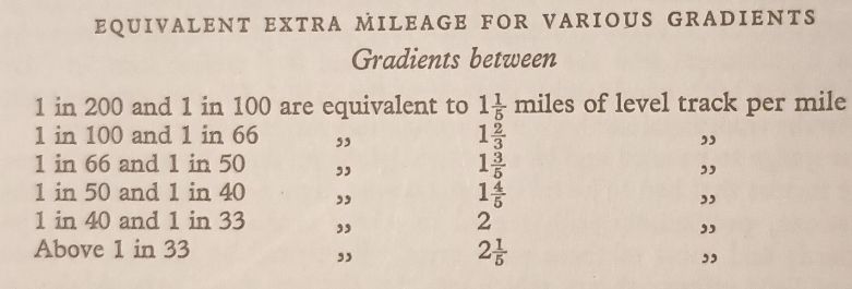
But if this was to be done, other problems immediately arose. Laying out a line on the route best calculated to serve the countryside inevitably meant that obstacles that could otherwise have been avoided had to be surmounted. Steep gradients, river and road crossings, sharp curves, particularly where the railway followed a road, were all likely to occur more frequently. Here, incidentally, the narrow gauge scored on all counts; it could take sharper curves, it took up less space on a roadside verge, the proportion of dead to live weight hauled was lower than on a standard gauge line, so that better payloads could be hauled up the gradients, and it was easier to run off both permanent and temporary sidings. Whatever gauge was to be used, however, the problems remained. Was it better to have a shortish, steep gradient or to make a deviation round the rise? Should the railway run along a public road or on its own right of way? Opinions differed, but obviously the need for economy often dictated the final decision. Quite elaborate Tables were calculated to show the effect of varying gradients on working and one is given below.” [1: p33-34]

Estimates provided by Davies of the effect of various gradients: Davies says that “No real account need be taken of gradients of less severity than 1 in 200 but that the stiffer the gradients that were encountered, the more economical it would be to avoid them, particularly as the carrying potential of a train would be determined to some extent by the stiffest gradient of any length found on the railway.” [1: p34]

Thus one or two fairly steep gradients could be tolerated providing, first, that they were short enough to be rushed, and second that the ruling gradient was sufficiently gentle so as not to exhaust the steaming powers of the locomotives. A ruling gradient of not more than 1 in 80 was recommended but 1 in 50 was, it appears, more often accepted as the maximum in practice.” [1: p34]

This table shows the sharpness with which load hauling powers drop off as the gradient increases. Taken from a thesis of the period, it assumes locomotives with a tractive force of about 321 Ib per ton weight (then thought to be the optimum for light railway engines) working at a maximum speed of 7 mph on gradients of any reasonable length. It will be seen how quickly, proportionately, the tonnage which can be hauled drops away once the ruling grade exceeds about 1 in 80. [1: p35]

Roadside running “was recommended wherever possible, especially for the smaller lines, both because it was economical in first cost, the land involved already being in most cases the property of the local authority, and because it was the route most likely to serve the community.” [1: p34]

Davies goes on to say that, “On one thing … all were agreed whatever was done about the route, economies should not be practised on the track itself. The initial cost of a well-built trackbed, with an adequate weight of rail, would pay for itself many times over in reduced maintenance costs and smoother running; and an interesting sidelight – many authorities, from Decauville to Sir A. P. Heywood, recommended steel sleepers rather than the usual wooden ones, as being stronger and longer lasting. This last suggestion was not widely adopted, although it proved its worth on light lines but the consequences of neglecting the earlier warning soon became all too plain. Minimum recommended rail-weights per yard for the various gauges were:” [1: p34-35]

  • 2ft gauge: 25 lb
  • 2ft 6in gauge: 30 lb
  • Metre gauge: 50 lb [1: p34-35]

These proved satisfactory in practice providing that adequate sleeper spacing and ballasting was provided, since these two factors have a considerable influence on the axle-load a given weight of rail will safely bear. The troubles of many light railways in their later years sprang from a parsimonious outlook when they were built, which compelled their constructors to use too few sleepers and very inferior ballast, often containing a high proportion of earth. … The main economies which it was felt could be effected came under three headings: accommodation, working arrangements, and manning, the first one of these being the most controversial, especially in this country. Collectively they make up the third tenet of light railway theory as propounded in the 1890s, which might well be summed up in Henry Ford’s famous slogan ‘Simplify and add Lightness’. All unnecessary frills were to be omitted. Complex signalling, interlocking of points and signals, gated level crossings, fencing, even the normal staff and token system used on single line railways, virtually all the safety measures so dear to the administrators, should be ignored and, indeed, were forgotten in most countries where the light railway idea took firm root. A system of train orders and, later, telephone communication, proved perfectly satisfactory for the slow and infrequent trains of such lines and could well have functioned over here, as was proved by the Glyn Valley Tramway which was a roadside light railway of continental type but which profited by its official classification to run its operations in a very free and easy manner without any serious mishap. As for gated level crossings, when these theories were being worked out, there was, of course, very little traffic on the roads and many lines were roadside anyway; even now [1964] the majority of continental lines do without gates. They have the occasional accident but rarely one sufficient to disturb anyone’s equanimity for long.” [1: p35-36]

This urge for economy extended, too, to the lineside buildings which, it was stressed, should be of the simplest and of a limited number of standard patterns. … Such things as raised platforms were considered unnecessary and, indeed, an encumbrance as, in order to increase the economy of working at wayside stations, goods and parcels sheds were often combined with the station house and the very sensible plan adopted of having a siding or loop directly in front of these for goods waggons, the main running line being a short distance away.” [1: p36]

The diagrams below illustrate the difference between UK practice and that on the continent.

Typical layouts of stations on light railways in the UK (A and B) and on the Continent (C and D). A and C represent typical intermediate stations, B and D represent passing/crossing places. Davies suggests that it is important to note the differing arrangements of goods facilities and the usual practice on continental railways of providing toilets at stations, something that was unusual for lines in the UK. [1: p41]

“Places of little importance were to have halts only, which, on the Continent at least, were and are often just a nameboard at a level crossing, with the possible addition of a small shelter.” [1: p36]

There was also the question of staffing. The IRC claimed that, in effect, railwaymen should be able to put their hands to almost everything. Among other things they suggested:

  • The possibility of giving up the fireman, or, at all events, being enabled to make him assist in other work apart from the engine, and engaging him as a simple fireman apprentice.
  • The use of carriages with a central gangway which allows of their being looked after by a single guard to examine tickets even in trains of as many as eight carriages.
  • Allowing the train staff (brakesmen of goods trains and firemen) to share in working points, handling baggage, etc., at the stopping places and intermediate stations.
  • People other than railway employces being engaged to look after stopping places of small importance.
  • Station-houses could be inhabited by men employed at various jobs on the railway, the stations being looked after by their wives, and it was even proposed that the wives should issue and collect tickets on trains. (In practice many light railways employed far too large a staff, although in later years, as competition grew, and conditions worsened, the staff numbers were of necessity reduced. Davies says that “Regrettably, it was often in the essential posts such as gangers that economies were made rather than in the more expendable administrative personnel.”) [1: p37]
  • In respect of the trains, “economies could, it was considered, be obtained by such devices as composite carriages for the lesser used classes, reduction of the number of classes, waggons of similar capacity to those on the main line if this was practicable, and particularly by careful study of the maximum axle-load and the maximum speed required, both of which, if kept to a reasonably low figure, would ease maintenance all round. A prominent supporter of this view was E. R. Calthrop, who advocated a uniform axle-load for all vehicles on a railway, adopting in practice a maximum load of 5 tons for a 2ft 6in gauge line laid with 30 lb rail, with a relatively low maximum speed of 15 mph; that his theory was sound is indicated by its success on the Barsi Light Railway in India; and by the Leek & Manifold Valley Light Railway in Staffordshire, the track of which needed no replacement at all during the thirty years life of the line.” [1: p37

However, that the track of many light railways lasted as long as it did was due not so much to careful planning as to infrequency of traffic. “Generally speaking it was considered that two trains a day would meet the requirements of most districts. ‘Transport‘ commented in 1894: ‘Almost all the places where light lines are asked for have at present only two connections by public vehicle each way daily, one in the morning and one in the evening. It would therefore be reasonable for poor lines to have only two trains each way daily’.” [1: p37]

Davies goes on to note that “it is of interest … that the same Journal also advocated the introduction of ‘motor trains’ or, as the French call them, ‘trains legères’ if circumstances justified additional services over busy parts of the line. These in practice, in the early years, usually consisted of an engine hauling one or two coaches but later on, of course, railcars were used. When one considers cases like that of the all-stations mixed train on the ‘Le Blanc-Argent’ line in Touraine, which took 14 hours to cover its 191 kilometres and was indicated on the public timetables as three separate trains, one realizes why such trains legères were considered desirable. Admittedly the [Le Blanc-Argent] train had to struggle through no less than four standard gauge junctions with their attendant complications but it was by no means alone in its tardiness. Even in the 1890s, however, the disadvantages of mixed trains had been recognized and the IRC recommended that, as soon as traffic on a line justified it, they should be abolished.” [1: p37-38]

Davies concludes that the theorists’ arguments of the 1890s, before the Light Railway Act of 1896 were that a line should be:

  • suitable for the traffic expected;
  • of service to the community; and
  • simple in construction and operation.

The theorists thought “of light railways as sub-standard lines designed to open up a district and to contribute traffic to the main line railways; they were to be constructed on the simplest pattern compatible with operating efficiency. This … entailed a number of restrictions in carrying power, train size and speed, but did not mean that the railway should be a ramshackle concern. If it was properly suited to its traffic there should be sufficient capital to build it substantially in comparison with that traffic it was to carry. Economies were to be realized mainly through throwing overboard all the elaborate trappings and working practices of the main lines and, depending on its circumstances, a line classed as a light railway might range from a 2ft gauge steam tramway only a few miles long to a fully equipped metre or 3ft 6in gauge line up to or even exceeding 100 miles in length. Standard gauge lines rarely came within this category unless they were of feeble length and laid with very light rails and equipment, since narrow gauge lines offered economies in capital cost which out-weighed their disadvantages.” [1: p38]

In practice, the UK was a relatively late adopter of light railway schemes. “A fair amount of legislation for, and, indeed, construction of local railways had already taken place by the end of the 1880s in various countries. But development was very patchy and the lines that had been built tended to adhere to the physical conditions governing the main line railways in their own country, more from lack of fresh thoughts on the subject than for any other reason. Thus, in Britain, for example, minor lines had high platforms, and goods sheds detached some distance from the main station buildings, neither of which practices, as we have seen, was considered necessary by the theorists. Indeed as late as 1902 there was so little clearly formulated planning on the subject in Britain that an eminent practising engineer found it necessary to write a manual to inform his colleagues of the practical principles involved in laying a light railway.” [1: p39][3]

There was “a surprising amount of agreement among existing continental light railway builders as to the basic requirements of a light railway except, of course, in the always invidious matter of gauge; and it was on the basis of existing practice that the theorists of the 1890’s were able to formulate their ideas. Nor was the considerable body of light railway theory so built up entirely the work of amateurs. The professional ‘International Railway Congress Association’,† an official body set up by most European and some other countries, maintained a standing committee to consider the subject of light railways and to sift out the best elements of existing practice.” [1: p39]

The recommendations relating to light railways by the 19th century theorists were followed to a significant extent. A good example is the case of railway gauges, always a thorny problem. Before the 1890’s there was a multitude of gauges in use, but very few light railways built after about 1895 did not conform roughly to one of the IRC’s four recommended gauge groups. There was general agreement over fencing, signalling and standardisation, although the rigour with which standardisation was persued depended on the country concerned. Davies highlights a problem experienced in France during WW1. … “France, merely laid down general rules and left individual companies to produce their own detailed specifications. The disadvantages of this were not apparent while vehicles remained on their home lines, but became plain when they had to run on other railways, as the French found out when the 1914-18 War forced them to strengthen their north-eastern light railways with stock from lines all over the country. The variations in coupling and braking systems in particular were numerous and severely taxed the ingenuity of the operating staff; while the Austrians, who had standardized with just this eventuality in mind, were able to reinforce their military railways with no trouble at all. The disadvantages also showed in peace-time when railways started to close down and other lines wished to buy their equipment.” [1: p40]

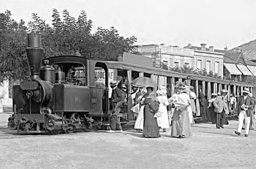
Steam Locomotive on the Tramway de Royan at the turn of the 20th century, (c) Public Domain. [5]

Davies highlights a few interesting matters:

A. Rather hazy distinctions between ‘light railways’ and ‘tramways’ – Tramways were usually lines of only local interest and running for the most part alongside public roads, these were typically exempt from state railway laws. Promotion and control were usually left in the hands of local authorities. “Yet these lines might not be ‘tramways’ in the generally accepted sense of the term today, but true light railways which just happened to run by the roadside. Indeed some considerable systems of what were officially classed as tramways arose, a typical example being the Tramways de la Sarthe in France, operating 20 connected lines of metre-gauge track, with a total length of 406.1 kilometres. Such lines usually had … wayside stations, … steam traction, and carried goods as an integral part of their traffic.” [1: p40,42] Ultimately, the only distinction between such tramways and a ‘light railway’ would be the likelihood that the light railway probably mainly kept to its own right-of-way.

B. The use of ‘concessions’ in most countries in Europe for their light railways – this practice was unusual in the UK in respect of light railways. It was, however, relatively commonplace in respect of tramways built in local roads in the UK. These were granted a fixed length of operation by a contractor with a first refusal for the local authority when the term came to an end.

In Europe, almost every country used some form of ‘concession’ system, “whereby companies did not simply go out and buy land with the right to build a railway on it and use it in perpetuity after an initial authorization, but were simply given powers to build a railway and run it for a fixed period as contractors, after which the position would be reviewed. Alternatively they might operate a railway already constructed by the state or by some other organization; and often the state reserved to itself the right to purchase the line at a specific time after construction. These concessions were of two main types which may conveniently be referred to by their French titles of ‘concessionaire’ and ‘fermier’.” [1: p42]

Davies tells us that “The ‘concessionaire’ company normally undertook to work a railway or railways ‘at their own risks and perils’. In other words. it had to pay its way or close. This was not quite so bleak a prospect as it might seem since the operation of the railway was often subsidized by a state or local authority and guaranteed interest might even be paid on the capital of the railway company concerned. Such companies often built their railway(s) in the first place and provided their own rolling stock.” [1: p42]

“The ‘compagnie fermière’ on the other hand, was solely an operating company and worked a railway on behalf of an owning organization, usually a local or municipal authority. It worked either as a completely controlled subsidiary to the authority, in which case profit did not come into the matter, or else contracted to operate the line for a fixed percentage of the gross receipts. This type of concession was used frequently in later years when the railway concerned was almost certain to make a loss but was considered of sufficient benefit to the community for its continued operation to be worth while.” [1: p42]

Davies continues: “It was in the granting of these concessions and in the various ways by which the concessionary companies were helped, that the attitudes of different countries showed themselves; and it was the terms under which such concessions were granted that often determined whether the light railway network of a country was a success or a failure. Where the state organized its secondary rail system, either by judicious financing or by direct control, lines were built sensibly and with reasonable success; a fruitful co-operation grew up between the State and the concessionaries. But where the State was not quite sure what it wanted, or where local authorities were allowed to have the major say in authorizing and constructing systems of any importance, the results, generally speaking, were not so good. This was probably due mainly to over-enthusiasm and to the desire to meet the demands of poor districts which felt the need of a railway as much as their more prosperous neighbours. The result in both cases was that promoters tended to be offered unduly favourable terms, with insufficient security on their part in return. Hence many lines were built that were of very doubtful viability under any circumstances and certainly unlikely to be a paying proposition. The construction of these uneconomic lines was often justified by the explanation that they were not expected to pay their way, initially at any rate, but were designed to benefit a region by opening up new districts, the local authority being quite willing to pay a subsidy to achieve this end. This argument was possibly valid where the operating company did not make a considerable profit out of the situation but such lines inevitably had to be offered under guaranteed terms which cost the local authority dearly. Moreover, the lines concerned were naturally very vulnerable to any improvements in road transport.” [1: p42-43]

C. Other Factors – affecting the viability of ‘light railways included:

  • Prestige: “The local company usually had its pride, and this led to considerably more expenditure on lineside fittings than was strictly necessary. In particular, station buildings tended to be substantial, … often of brick and stone, and of two stories where a simple hutment would have sufficed. Too often, also, unnecessarily elaborate workshops were provided for each small company although big private concerns, to give them their due, often had a central workshop where all heavy repairs were done.” [1: p43]
  • An operational problem: often ignored by early theorists. For “minor railways which formed dead-end branches, the obvious place for the operational headquarters and running sheds was at or near the junction with a main line railway. Yet traffic flow usually required the first train out in the morning to be from the far terminus to the junction. Hence a sub-shed, capable of storing one or two locomotives, and equipped with fuelling facilities, and even at times living accommodation, had to be provided at the far terminus. On a system with several branches this could well be a considerable expense.” [1: p43]
  • Staffing: was often on a more lavish scale than the theorists or IRC would have liked. Dvvies, in 1964 writes: “It was far more lavish in many cases than was strictly necessary, as has been shown by a number of French minor lines in recent years. Such lines as the CFD du Vivarais, or the late-lamented CFD du Tarn have, since the war, cut their personnel by almost half; and for a 55 miles system like the Tarn this meant a decrease of some forty men. It is being wise after the event, but it is plain that the fortunes of some minor concerns would not have been so bad, had they controlled their staffing ratios more realistically in the first place.” [1: p43]
  • Dual Effects of Traditional Ideas of Railway Building: Davies sees these as a ‘standard gauge mentality’ and a failure to appreciate the results of improvements in road transport. Both, he says, led to stagnation of ideas: “The standard gauge mentality was, as the name implies, a fixed idea among officials involved in planning light railways, to avoid the, as they saw them, disruptive effects of a multiplicity of gauges and standards. It implied a large degree of conformity with main line standards in signalling and other matters as much as conformity in the actual gauge. It was by no means always destructive but in many cases a railway built on these principles meant one far too large and elaborately equipped, hopelessly uneconomic for the traffic it was to carry and for the revenue which could be expected. In extreme cases it simply meant that no railway was built at all.” [1: p44] … Davies goes on to say that on the Continent and in Britain from about 1910, the “light railway builders of the period often stuck too closely to the mass of theoretical dicta which had appeared about the turn of the century. In France especially, but also in other countries they went on planning tortuous roadside lines, designed for slow and infrequent trains, without realizing that road competition was becoming even then a very real factor. The theorists had not visualized motor transport; the builders of the 1910’s seem to have ignored its presence to a surprising degree. The result was the construction and operation of such systems as the Tramways de la Corréze in central France. This was an extensive system of no less than five separate lines on the metre gauge, totalling 179.5 km and opened as late as 1913-14. Yet it was for the most part roadside, serving small communities, laid with light rail and equipped with 4-wheel stock of a pattern already outdated. Even the locomotives were small 0-6-0T’s designed for the haulage of light trains at slow speed. Even after the 1914-18 War some of the light railways that were promoted then followed much the same pattern and it is all the odder that, while sticking religiously to what were becoming, in the circumstances, outmoded concepts, the builders of such lines were not afraid of constructing considerable engineering works if the need arose. The TC [Tramways de la Corréze] mentioned above had, for example, the viaduct of La Roche Taillade, a huge suspension bridge noted throughout France for its superb design, … while the Côtes du Nord system, which was building such lines as late as 1925, was also a pioneer in the use of pre-stressed concrete structures and used the material extensively for viaduct work.” [1: p44]
Viaduc de Roche-Taillade sur la Luzege 92 metres high, 160 metres long with piers/stanchions of 126 metres in height. [4]

Conclusions

The success of a light railway was likely to vary in practice with the conditions it encountered rather than its adherence to a particular set of ideas. Davies concludes that “in virgin territory overseas, the light railways had ideal conditions for survival; long hauls; great potential for traffic development; and a fair chance of expansion provided the ‘standard gauge mentality’ of colonial administrators could be overcome. On the Continent and at home, on the other hand, they were more hidebound by traditional ideas, problems of prestige, etc., and were far more subject to competition which developed from other forms of transport. ” [1: p45]

A short article picks up on a short piece in The Railway Magazine of August 1905 which reflected on the early years of Light Railways after the 1896 Act. This can be found here. [6]

References

  1. W. J. K. Davies; Light Railways: their rise and decline; Ian Allan, London, 1964.
  2. J. C. Mackay; Light Railways for the United Kingdom, India and the Colonies; Institution of Civil Engineers (facsimile ed.), London, 2011.
  3. R. M. Parkinson; Light Railway Construction; Longmans, Green & Co., London and New York, 1902; via https://archive.org/details/lightrailwaycon00parkgoog/page/n3/mode/2up, accessed on 4th July 2026.
  4. https://i.ebayimg.com/images/g/EV8AAOSwsRpneCcF/s-l1600.webp, accessed on 6th July 2026.
  5. https://de.wikipedai.org/wiki/Datei:Locomotive_vapeur_de_Tramway_de_Royan.jpg, accessed on 6th July 2026.
  6. https://rogerfarnworth.com/2024/09/17/light-railways-in-the-uk-the-early-years-after-the-1896-act-the-railway-magazine-august-1905
  7. https://media.lrrsa.org.au/irok230/Light_Railways_230.pdf, accessed on 6th July 2026.
The Campbeltown and Machrihanish Light Railway. …

The featured image for this article shows ‘Argyll’ (a Barclay built 0-6-2T) taking its train Southeast out of Campbeltown before turning Southwest to run round the South side of the town. This image was shared on the Machrihanish Online Facebook Page on 26th July 2023. (c) Public Domain. [22]

The Campbeltown and Machrihanish Light Railway was a 6-mile, 2 ft 3 in (686 mm) narrow-gauge railway in Kintyre, Scotland, operating between 1906 and 1934. It ran from Campbeltown’s New Quay to Machrihanish, primarily serving coal traffic while also transporting tourists and locals across the peninsula.

It replaced an earlier industrial tramway which was built in 1876 and used by the Argyll Coal and Canal Company, which before this had replaced a canal.

In 1876, the line followed the line of the old canal that used to be used to transport coal.

In 1905/6 the curves were improved and the steeper gradients eased.

Most of the output from the colliery was used locally – by residents and the 34 distilleries. The coal business was largely seasonal and the owners looked for a use during the summer months and in 1905/6 a light railway (2’3″ gauge/686mm)was built to replace the tramway and at the same time it was extended to Machrihanish and along the front in Campbeltown.

Opened in 1906, the Campbeltown and Machrihanish Light Railway was Scotland’s only passenger-carrying narrow-gauge railway and operated as an isolated line with no connection to the national rail system.

Ultimately, the railway suffered from increased road competition from bus services, financial problems, and reduced coal quality in the early 1930s, closing in 1932 (officially 1933) and being dismantled in 1934.

Stenlake Publishing has recently published a new ‘Oakwood Press’ 3rd edition of a book first published by David & Charles in 1970. A second edition was published in 1993 by Plateway Press. The new edition has minor updates and some ‘new’ old photographs. The author, now in his 90s, visited Campbeltown in the early 1930s and again in 1941 thus sparking his interest in this operation. In the 1950s he decided to build a scale model and his new bride was only too happy to accompany him to Campbeltown on their honeymoon so he could take the necessary research photographs of what was left of this line built to move coal economically from pit to ship. The route was from the colliery near Machrihanish across the Kintyre Peninsula to the pierhead at Campbeltown. Coal strikes in the 1930s, competing services from buses, financial problems and the fact that Machrihanish coal wasn’t of especially high quality, all contributed to the inevitable demise in the mid 1930s, but traces of the line remain visible along the route today.

The Route of the Line – Campbeltown to Machrihanish

The route of the line is shown below on contemporary Ordnance Survey mapping which was revised in 1914/1915 and published in 1921. These map extracts are supported by Google Maps satellite imagery and Google Streetview images. Occasionally other images illustrate the particular section of the route. …

The Railway Harbour branch ran out onto New Quay and along Hall Street. Ordnance Survey mapping revised in 1915 and published in 1921. [4]
The same area in the 21st century. [Google Maps, May 2026]

The Harbour branch did not just see use by goods trains. Once steamer traffic began to bring tourists to Campbeltown, the train would take them across to Machrihanish, © Public Domain. [3]

A similar view in the 21st century: Hall Street is a dual carriageway with a central verge. The light railway occupied the centre of the carriageway where there is now a grass verge. [Google Streetview, November 2021]
Another postcard view: this is a closer view of the passenger train sitting in the centre of Hall Street. This image was shared on the Disused Stations Facebook Group by Gordon Thomson on 15th February 2023, © Public Domain. [8]
A single-coach train sits on Hall Street: both locomotive and coach seem to be in a pristine condition. This photograph  could have been taken as early as 1906, © Public Domain. [9]
The route of the Harbour branch followed the shore before crossing Kilkerran Road. [4]
‘Argyll’ (a Barclay built 0-6-2T) takes its train Southeast out of Campbeltown before turning Southwest to run round the South side of the town. This image was shared on the Machrihanish Online Facebook Page on 26th July 2023. (c) Public Domain. [22]
The same area in the 21st century. There is a footpath visible through the park between Kilkerran Road and the foreshore. The old railway route approximates to the line of the footpath.  [Google Maps, May 2026]
This view looks Southeast along the line of the old railway. [Google Streetview, November 2021]
A closer satellite view of the point where the old railway route crosses Kilkerran Road. [Google Maps, May 2026]
Looking back from the location of the level crossing, through the park towards the harbour at Campbeltown, the centre line of the old railway runs through the first tree at the centre of this image and then follows the path back towards Hall Street. [Google Streetview, November 2021]
Looking forward from the location of the road crossing along the route of the old railway. The path at the centre of this image follows the line of the old railway. Ahead among the trees was a length of relatively deep cutting. [Google Streetview, November 2021]
Looking back towards Kilkerran Road from the line of the old railway, © James Emmans and authorised for reuse under a Creative Commons licence (CC BY-SA 2.0). [11]
The Harbour branch ran in deep cutting towards the location of sidings on Stewart Street. These map extracts come from the Ordnance Survey mapping, revised in 1915 and published in 1921. The NLS provides these maps free and without copyright restrictions. [4]
The same area as it appears on Google’s satellite imagery in the 21st century. [Google Maps, May 2026]
The cutting mentioned and shown above. The photograph shows the footpath which now follows the line of the old railway, © Steve Partridge and licensed for reuse under a Creative Commons licence (CC BY-SA 2.0). [10]
The deep cutting on the right side of this colourised postcard image suggests that the train shown has just left the seashore to the Southeast of Campbeltown and is heading Southwest along the South side of Campbeltown. AT that location there is a significant stand of trees much matching that shown behind the train in this image, but I would have expected there to be some signs of the yard which can be seen on the OS map extract below. This picture was shared on the Machrihanish Online Facebook Page on 15th May 2019, (c) Public Domain. [25]
The sidings which sat behind the Gaelic Church, off Stewart Street. The Harbour line enters this map extract in the bottom-right. The line to Machrihanish leaves in the bottom-left corner of the image: the 25″ Ordnance Survey of 1914 published 1921. [4]
The same location on the 25″ Ordnance Survey revision of 1898, published in 1899. This shows the older ‘tramway’ which did not have access to the harbour and Hall Street, terminating instead at a ‘station’ with road access from Stewart Street. To the West of this location the old tramway formation became the light railway formation. [13]
A similar area on Google’s satellite imagery in the 21st century. The Gaelic Church sits approximately in the centre of this image. The area occupied by the old light railway which sat to the West of the church had now been redeveloped. The location of the triangular junction, coal depot and carriage shed remains undeveloped, with the exception of a helicopter landing pad for the hospital which sits on the old railway site. [Google Maps, May 2026]

The next few photographs show the site of the sidings as it is in the 21st century, beginning at the North end and wandering to the South. …

Looking South from Stewart Street, the buildings on the left straddle the top of the site. The ginnel behind the blank gates and the single-storey building to the right were present when the site was in use by the old light railway. [Google Streetview, December 2021]
Looking South through the site with the arch of the modern buildings behind the camera. [Google Streetview, October 2015]
Further South through the site, this view continues to look to the South. [Google Streetview, October 2015]
This view from the hospital access road looks North through the site of the old sidjngs towards Stewart Street. [Google Streetview, December 2021]
Turing through 180°, the view faces South from the same location as the image above. Hospital buildings sit directly over the old site. [Google Streetview, December 2021]
Further to the South, peering over the wall we can see the open grass area that was once the triangular railway junction in Campbeltown. [Google Streetview, December 2021]

The line to Machrihanish set off just to the South of West and immediately crossed what is now Ralston Road at an unmanned, ungated level crossing. ….

The road crossed by the railway is now known as Ralston Road. [4]
Approximately the same area as it appears on Google satellite imagery in the 21st century. The fence line on the right of this image on the North side of Limecraigs Road marks the approximate Centreline of the old railway. The line of the old railway now passes through the hosing estate on the West side of this image. [Google Maps, May 2026]
Looking East from Ralston Road, the fence line sits on the line of the old railway. [Google Streetview, November 2021]
Looking West from Ralston Road, the Centreline of the old light railway passed through the house at the centre of this image. [Google Streetview, November 2021]
The line continues West but on a West-southwest trajectory. [4]
A series of red dots give an approximation to the route of the old railway. A relatively modern housing estate sits over the old line. [Google Maps, May 2026]
The old line curved round to just North of West before crossing what is now Tomaig Road. [4]
Again, red dots show the approximate alignment of the old railway on this next extract from Google’s satellite imagery. The alignment becomes visible once the housing estate is left behind. [Google Maps, May 2026]
A closer view of the location of the level-crossing. The red dots indicate the line of the old railway. [Google Maps, May 2026]
Looking back along the line of the old railway towards Campbeltown. [Google Streetview, November 2021]
Looking West from the same crossing, along the route of the old railway, towards Machrihanish. [Google Streetview, November 2021]
The line ran on Northwest from the crossing at Tomaig Road. [4]
The same length of railway shown on the 21st century ESRI satellite imagery provided by the NLS. Its route is easy to see. [14]

This next map extract shows the line as far West as the edge of the Ordnance Survey map sheet. [4]

A similar length of the line as it appears on the ESRI satellite imagery provided by the NLS. The resolution on this image is not as good as that on the satellite imagery provided by Google but none-the-less, the route of the old light railway can easily be made out. [15]
The line continued Northwest to another level crossing (top-left) over what in the 21st century is the B843. [5]
A similar length of the line is shown in this satellite image. The route of the line can be picked out, running from the bottom-right towards the top left, where it crosses the B843. [Google Maps, May 2026]
A closer view of the location of the level-crossing. The red dots approximate to the line of the old light railway. [Google Maps, May 2026]
Looking back along the line of the old railway from the level-crossing at the B843, the fence line beyond the tree in the middle fairground marks the line of the railway. [Google Streetview, November 2021]
Turning through 180° at the same location, the tree in the centre foreground sits on the line of the old light railway. [Google Streetview, November 2021]
From the level-crossing, the line ran on to the West. [5]
The field boundary running West from the location of the level-crossing marks the line of the old light railway. [Google Maps, May 2026]
Two relatively tight curves on this next map extract saw the line turning to the Northwest. [5]
The field boundaries running across the centre of this satellite image mark the line of the old railway. [Google Maps, May 2026]
A wide sweeping curve took the line on to the West. [5]
The red dots show the approximate line of the old railway. The two most westerly of these dots are perhaps a little too far to the North to actually sit over the old line. [Google Maps, May 2026]
The line continued West-southwest. [5]
Again, the line of red dots approximate the route of the old railway. By the 21st century, much of the formation has been ploughed into the fields surrounding it. [Google Maps, May 2026]
This next map extract shows the old railway as it continued heading West-southwest. [6]
A similar length of line is again shown on the 21st century satellite imagery provided by Google. The line of the old light railway is a little easier to identify running West-southwest from the top-right of the image towards the lower-left side. [Google Maps, May 2026]
The line continues heading West-southwest before beginning to curve round to the West. [6]
The route of the old railway follows the field boundaries which run from top-right to a little below centre-left on this Google satellite image. [Google Maps, May 2026]
The line crosses this map extract from right to left at the centre of the extract. [6]
Approximately the same area as it appears on Google’s satellite imagery. The line of the old railway runs East to West a little below the centre of the image. [Google Maps, May 2026]
Only at the left hand side of this extract does the line turn a little towards the Northwest. [6]
The route of the old railway is a little harder to make out on the satellite image. The string of red dots show it’s approximate alignment. [Google Maps, May 2026]
The turn to the Northwest is much more evident on this next extract from the 25″ Ordnance Survey of 1914/15 published 1921. [6]
The line of red dots on this next extract from Google’s satellite imagery is the best that I can do to show the approximate line of the old railway. Much of this length of the line has been ploughed back into the landscape. [Google Maps, May 2026]
Now curving back towards the West, the line approaches the Machrihanish Water. [7]
The red dots on this image mark the approximate line of the old railway at each edge of the satellite image. The field boundary between marks the line of the railway. [Google Maps, May 2026]
Adjacent to West Machrihanish, Machrihanish Water ran alongside the railway. Just to the West of the access road to West Machrihanish the light railway branched to serve the colliery and the village of Machrihanish. The line to the colliery ran parallel to Machrihanish Water, that serving the village turned away to the Southwest. [7]

West Machrihanish farm in 2026, also showing the access road and Machrihanish Water. The line of the old railway turning away for Machrihanish village is marked in red. The line to the Colliery ran alongside Machrihanish Water. [Google Maps, June 2026]

The next map extract shows the site of Argyll Colliery which mined the Machrihanish Coalfield, the ‘Main Coal’ was the principal coal seam at this location and is some 3 to 4m thick. A further, higher seam known as the ‘Kilkivan Coal’ has also been worked by the colliery.

The site of Argyll Colliery. [7]

A similar area in the 21st century. The lines drawn are only approximate. [Google Maps, June 2026]

Mining was taking place at the site of the colliery “before the 16th century, largely in connection with a local sea-salt industry. Similar but very small scale activity also took place on the northeast coast of the nearby Isle of Arran. It continued at a low level through to the late 18th century when a new pit was sunk at the Argyll Colliery, ushering in the coalfield’s busiest period which lasted until the closure of the mine in 1929, following a fire in 1925. Much of the coal was used to fuel the area’s numerous distilleries. The coalfield was linked to Campbeltown by a canal from the late 18th century and by a tramway/narrow-gauge railway at the end of the 19th century.” [16]

After closure in 1929, plans were in the 1930s “to distil oil from Machrihanish coal, but they were never put into practice. The mine was reopened in 1946, … with two drift mines … serviced by modern machinery.” [17]  The mine, however, closed permanently in 1967.

A colourised postcard image of the pit head at the Argyll Colliery. This image was shared on the Machrihanish Online Facebook Page on 11th August 2019, (c) Public Domain. [2]

For more about Argyll Colliery, please click here, [18] here. [19]

We continue to follow the main line through to Machrihanish Station. …

Having turned to the Southwest away from the branch into the colliery the main line then crossed the road from Campbeltown to Machrihanish. The crossing can be seen at the right side of this map extract. [7]
Approximately the same area as shown on the map extract above. The red line gives the approximate route of the old railway. It is difficult to finally fix the location of the crossing as no historic features remain at the location and the caravan park post dates the line by some time. The exact location of the crossing may be as much as 50 metres to the West of the point that the red line crosses the road, perhaps not as much to the East. [Google Maps, June 2026]

Looking West along the B843 at the approximate location of the railway crossing. [Google Streetview, November 2021]

Looking East along the B843 at the approximate location of the railway crossing. [Google Streetview, November 2021]

About 50 metres to the South of the B843, the line ran parallel to the road. [7]
Approximately the same area as shown on the map extract above, as it appears in satellite imagery in the 21st century. [Google Maps, June 2026]
The line to the South of the relatively large homes which fronted onto the B843 in Machrihanish. [7]
Roughly the same area in the 21st century. The line ran behind the properties which still face out onto the B843. [Google Maps June 2026]
A coluorised postcard image showing ‘Argyll’ arriving at Mchrihanish Railway Station sometime in the 1920s. This image was share on the Machrihanish Online Facebook Page on 26th July 2019, (c) Public Domain. [25]
Machrihanish Railway Station sat behind (to the South of) the village. It was a simple two road station with passing loop. [7]
Again, approximately the same area as covered by the map extract above. The red lines approximate to the railway – with a simple passing loop in the old station. As can be seen a modern estate has been built over the site of the old railway station. [Google Maps, June 2026]
Machrihanish: the railway sat behind the buildings shown here, (c) Public Domain. This old postcard image was shared on the Machrihanish Online Facebook Page on 8th September 2019. [

The backs of the buildings at Machrihanish in 1905, before the railway arrived in the village, (c) Public Domain. [20]

A view of Machrihanish village from the Northeast soon after the turn of the 20th century (c) Public Domain. [21]

Machrihanish railway station with ‘Argyll’ a Barclay built 0-6-2T which can be seen more easily in the image below. (c) Public Domain. [1]
‘Argyll’, Andrew Barclay & Sons 0-6-2T Works No. 1049 of 1906, is in charge of a rake of what appears to be 4 of the 6 coaches owned by the Campbeltown and Machrihanish Light Railway. The six coaches built for the line all came from R. Y. Pickering. The location is probably Machrihanish Railway Station. This image was included in The Railway Magazine of February 1920, © E. A Gurney-Smith, Public Domain. This image can be found in various places online, it was shared by Dan Quine on the Narrow Gauge Enthusiasts Facebook Group on 5th April 2021. [12]

A superb painting of ‘Argyll’ by Jonathan Clay can be found here. [23]

Looking South along the short station approach road, now named ‘Bayview’. [My photograph, May 2026]
Looking North on the same length of road. [My photograph, May 2026]
At the same location as the last image but facing South. [My photograph, May 2026]
Turning to face East into what was once the site of the Railway Station and is now ‘Bay View’. [My photograph, May 2026]
Looking East along what was the line of the old railway from the location of Machrihanish Railway Station. [Google Streetview, November 2021]
‘Argyll’ or ‘Atlantic’ awaiting a next duty on the line. This image was shared on the Disused Stations Facebook Group by Gordon Thomson on 15th February 2023, © Public Domain. [8]

The railway owned two large tank engines built by Barclays of Kilmarnock named the “Argyll” and “Atlantic” together with three smaller engines inherited from the colliery. Its six unique large coaches handled the passenger business and there were 150 colliery owned coal wagons.

Links to other sites, blogs, articles

References

  1. https://www.facebook.com/groups/169965873834335/posts/1720525862111654, accessed on 30th June 2026.
  2. https://www.facebook.com/photo.php?fbid=2350515415035270&set=pb.100063155654203.-2207520000&type=3, accessed on 1st July 2026.
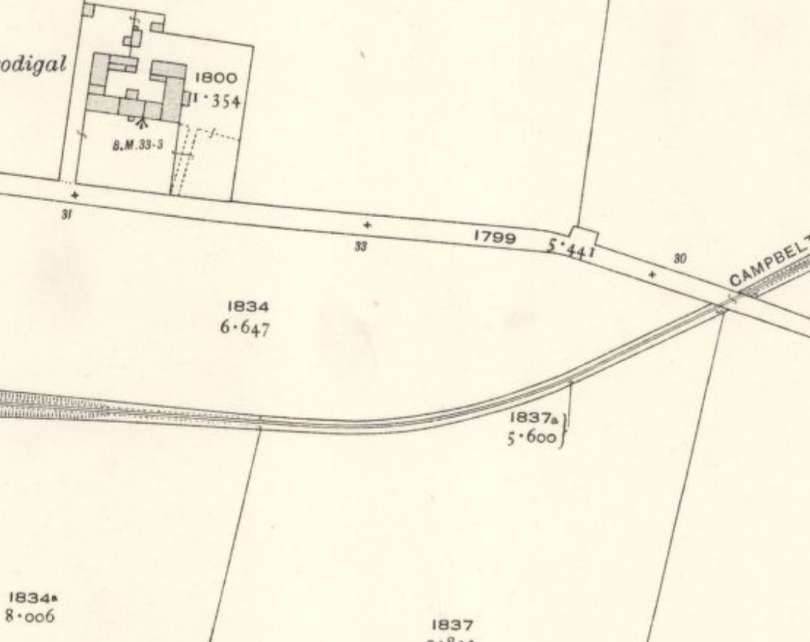
  3. https://www.airbnb.co.uk/rooms/1333351742651568177?_set_bev_on_new_domain=1779435972_EANDk3YzNmMTIyZG&set_everest_cookie_on_new_domain=1779435972.EAOTg3NDhlNmVkMDlkOW.nzC8ycC2pcO-Eo_DbSM_xowJUhqVWkKW93L_Y-WO6NI&source_impression_id=p3_1779435973_P3gs1P0wiIMMOgVk&modal=PHOTO_TOUR_SCROLLABLE&modalItem=2067524742, accessed on 22nd May 2026.
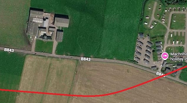
  4. https://maps.nls.uk/view/82866012, accessed on 13th May 2026.
  5. https://maps.nls.uk/view/82866006, accessed on 13th May 2026.
  6. https://maps.nls.uk/view/82866000, accessed on 13th May 2026.
  7. https://maps.nls.uk/view/82865994, accessed on 21st May 2026.
  8. https://www.facebook.com/share/p/1H6s5J2QDR, accessed on 22nd May 2026.
  9. https://commons.wikimedia.org/wiki/File:Campbeltown_and_Machrihanish_Light_Railway_-_Argyll_-_0-6-2T_built_1906_by_Andrew_Barclay_-_2ft_3inch_light_railway_built_in_1905_and_closed_in_1933.png, accessed on 22nd May 2026.
  10. https://www.geograph.org.uk/photo/618505, accessed on 22nd May 2026.
  11. https://www.geograph.org.uk/photo/5154005, accessed on 22nd May 2026.
  12. https://www.facebook.com/share/p/17YGPh2uQz, accessed on 22nd May 2026.
  13. https://maps.nls.uk/geo/explore/#zoom=16.8&lat=55.42136&lon=-5.60560&layers=168&b=ESRIWorld&o=100, accessed on 23rd May 2026.
  14. https://maps.nls.uk/geo/explore/#zoom=16.7&lat=55.41981&lon=-5.62128&layers=168&b=ESRIWorld&o=0, accessed on 23rd May 2026.
  15. https://maps.nls.uk/geo/explore/#zoom=16.7&lat=55.42049&lon=-5.62441&layers=168&b=ESRIWorld&o=0, accessed on 23rd May 2026.
  16. https://en.wikipedia.org/wiki/Machrihanish_Coalfield, accessed on 9th June 2026.
  17. https://www.machrihanish.net/mining-at-machrihanish/nggallery/slideshow, accessed on 9th June 2026.
  18. https://theroadtodrumleman.wordpress.com/2017/02/08/argyll-colliery-the-pit-baths, accessed on 30th June 2026.
  19. https://www.facebook.com/groups/411524423288996/posts/1531038634670897, accessed on 30th June 2026.
  20. https://www.ebay.co.uk/itm/358620977945, accessed on 30th June 2026.
  21. https://www.ebay.co.uk/itm/396540988984, accessed on 30th June 2026.
  22. https://www.facebook.com/photo.php?fbid=618175316964318&set=pb.100063155654203.-2207520000&type=3&locale=en_GB, accessed on 1st July 2026.
  23. https://www.facebook.com/photo.php?fbid=3840078236082171&set=p.3840078236082171&type=3, accessed on 1st July 2026.
  24. https://www.facebook.com/photo.php?fbid=2399835046769973&set=pb.100063155654203.-2207520000&type=3, accessed on 1st July 2026.
  25. https://www.facebook.com/photo.php?fbid=2323275297759282&set=pb.100063155654203.-2207520000&type=3, accessed on 1st July 2026.