Tag Archives: Alstom

Egyptian Rail News – Summer 2026

Egyptian National Railways is the national railway network of Egypt. Founded in 1854, it is the oldest railway system in Africa and the Middle East. [7] A separate article provides more detail about the history of the railways of Egypt which can be found here. [9] Other articles are under preparation in July 2026.

This article focuses on relatively recent news about the railways of Egypt. …

A. Cairo Monorail Project: The 56.5km East Nile line began operations in March 2026, serving 22 stations with driverless technology, reducing Cairo congestion. A second line, bringing the total network to over 100km, is under development.

B. High-Speed Network: Siemens Mobility is constructing a 2,000 km network, featuring Velaro and Desiro HC trains traveling up to 250 km/h, covering 60 cities.

C. Modernisation: of Egypt’s 10,000 kilometre rail network. ……

A. Cairo Monorail Network

Recent articles about various railways in Egypt include the news that Egypt has just opened a new monorail, 56 kilometres in length.

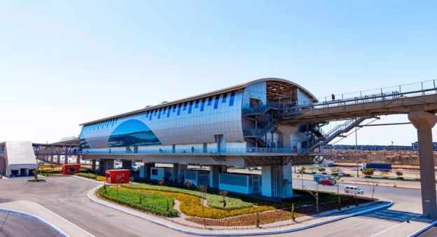
The featured image shows one of the twenty-two station s on the route. [1][2]

Solomon Ekanem reports that Egypt has officially launched the 56.5-kilometre East Nile monorail – Africa’s longest – marking a major milestone in the country’s push to modernise urban transport and expand green mobility infrastructure.

The East Nile monorail, connects Cairo’s Nasr City to the New Administrative Capital. It is a driverless monorail which calls at 22 stations. It is intended to ease congestion and improve urban connectivity. It is Africa’s longest single monorail line and part of the continent’s largest monorail network when combined with a second line. The eco-friendly, automated system reduces energy consumption by 30% compared to conventional electric rail.

President Abdel Fattah al-Sisi inaugurated the driverless system on Friday 20th March 2026 and then travelled alongside families of fallen Egyptian soldiers on the monorail from the Al-Fattah Al-Alim Mosque station to the Financial District, passing through key residential zones.

Transport Minister Kamel al-Wazir described the project as a “civilizational leap,” noting that it aligns with government efforts to deploy eco-friendly transport systems that reduce fuel consumption and road congestion. The rubber-tyred, fully automated system operates on elevated tracks, minimizing disruption to existing road networks.
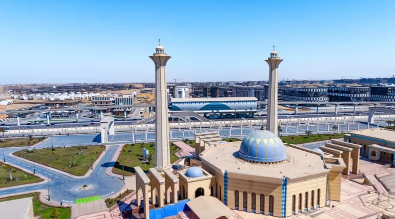
El-Mosheer Tantawy Mosque sits close to the monorail, one station of the monorail can be seen beyond the mosque in this image. [1][2]

The East Nile monorail … is part of a broader network — the “Cairo Monorail” system — which includes a second line linking 6th of October City. When both lines are combined, the network stretches to about 96 km, making it Africa’s largest monorail system overall. In simple terms, the East Nile route holds the record for a single line, while the full Cairo network holds the continental record for total system size. Built by a consortium including Alstom, Orascom Construction, and Arab Contractors, the project features 40 trains capable of reaching speeds of up to 80 km/h, with intervals as short as 90 seconds. The system integrates with Cairo’s Metro Line 3 and the Light Rail Transit (LRT), with future links planned to Metro Lines 4 and 6.” [1]

Equipped with platform screen doors, LED displays, and accessibility features, the monorail is expected to play a central role in reshaping Cairo’s urban mobility and supporting the shift toward sustainable transport.” [1]

Ekanem’s report is echoed by a report in Egypt Today. [2]

Cairo Monorail was first conceptualized in the late 2010s to combat the rise of traffic in the Greater Cairo area, and to provide a rapid transportation option for suburban residents. The Monorail was also thought of as a rail link between Cairo and Egypt’s New Administrative Capital. “Funding for the project was secured and obtained through a mix of local and international investments. This included a substantial loan facilitation agreement between the National Authority for Tunnels and JP Morgan Europe Limited, as well as contributions from other financial institutions such as the European Bank for Reconstruction and Development (EBRD) and the European Investment Bank (EIB). The total funding amounted to approximately 4.5 billion Euros.” [4]
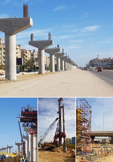
It was reported in August 2019, that French rolling stock manufacturer, Alstom, would lead a consortium which includes The Arab Contractors: Osman Ahmed Osman & Co and Orascom. The consortium would sign a 2.7 billion Euros contract to design, construct, operate, and maintain the two monorail lines. Upon completion of construction, the consortium will operate and maintain the network for 30 years. [4]

Hill International highlighted their involvement with the project in a post on LinkedIn four years ago. They were providing project management, design review, and implementation supervision services for the New Administrative Capital City and 6th of October City (East and West) Lines. [3]

B. High-Speed Network: This network is a planned 2,000 km network which Siemens Mobility is constructing. It will feature Velaro and Desiro HC trains traveling up to 250 km/h, covering 60 cities. The network will include three lines:

Line 1 (Green Line): Connects Ain Sokhna to Marsa Matrouh via Cairo.
Line 2: Connects Cairo to Abu Simbel.
Line 3: Connects Qena with Hurghada and Safaga.
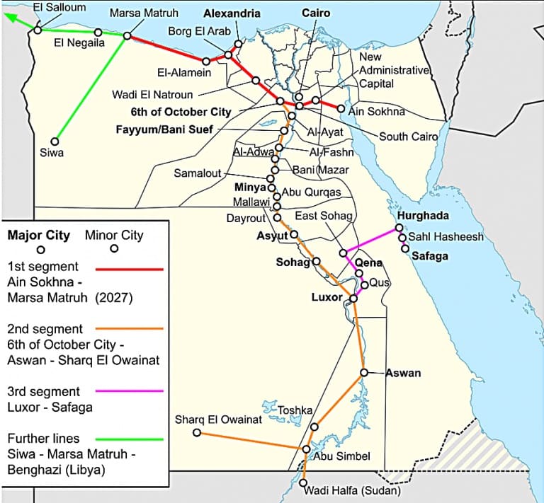
Egypt’s planned High Speed Network © Abs616 and licensed for reuse under a Creative Commons licence (CC BY-SA 4.0). [6]

The project includes 15-year maintenance by Deutsche Bahn and involves upgrading 7 key rail stations via Thales, focusing on increasing freight capacity to 13 million tonnes annually.

Egypt has a bold vision to build one of the world’s largest high-speed rail networks. Siemens Mobility is committed to delivering fully integrated, sustainable transportation solutions tailored to Egypt’s unique environment. The High Speed rail project “will span over 2,000 kilometres. It will ultimately connect all the major cities and reach nearly 90% of the population. Once complete, Egypt will have the sixth-largest high-speed network in the world. It will significantly reducing travel times, cutting CO₂ emissions, and boosting sustainable local economic development.” [6]

Siemens Mobility’s 15-year maintenance commitment covers the entire fleet for Egypt’s new high-speed rail network ensuring long-term operational excellence. This network will cut travel times by up to 50%. It will offer millions of passengers safer, more reliable, and more comfortable journeys. [6]

Currently completed to over 65%, the first phase of Egypt’s Ain Sokhna to Marsa Matrouh high-speed train is set to begin operations in 2027. The 670-kilometre line will include 21 stations! [6]

C. Modernization: In addition to new lines, Egypt is modernizing its existing 10,000 km network with new trainsets from Talgo, locomotives from Progress Rail, and new traffic control systems to improve efficiency.

The Railway Gazette International reported in September 2025 that Hitachi Rail has deployed a centralised traffic control system to manage 19 stations on the 200 km Cairo to Alexandria line. [5]

The initial contract for the programme was signed in 2013, and has since been extended to encompass more than €100m of investment. The mechanical and electrical signalling has been replaced with a modern electronic system, including digital interlockings, new signals and motorised drives. A fixed and mobile telecommunications system has been installed, with drivers able to communicate with the operations manager in case of emergency or failure. Level crossings have been modernised, and technical buildings constructed.” [5]

The modernisation project will enable Egyptian National Railways to increase the maximum speed of trains by 40 km/h to 160 km/h, reducing the journey time between the two cities to 2½ h. The route’s throughput is also set to grow by 40% to a maximum of 286 trains/day. A progressive increase in the number of freight trains is planned, allowing the line to carry 15 per day in 2030 and 50 per day by 2060.” [5]

In November 2025, TravelMole.com reported that Egypt had showcased a new high-speed train. [6]

On 10th November 2025, German technology giant Siemens unveiled the Velaro high-speed train in Cairo, which had been specifically adapted to withstand the harsh climate conditions of Egypt. The official presentation occurred during TransMEA 2025, the region’s leading exhibition for transportation and logistics in the Middle East and Africa. The Siemens Mobility Velaro high-speed train is specially adapted for Egypt’s desert conditions. It can reach a speed of up to 250 km/h and offers seating for 489 passengers. The company will deliver 41 Velaro trains to the Egyptian rail network.” [6]

On the same day, “the Desiro HC regional train successfully completed its first train run on newly constructed tracks near the 6th of October Depot, West of Cairo. The Desiro High-Capacity regional train is a key element of Egypt’s new high-speed rail network, with 94 trains set to provide efficient and comfortable regional transport. Specially adapted for Egypt’s climate, each train offers up to 849 passenger spaces and advanced features such as air conditioning,” [6]

With a top speed of 160 km/h, the Desiro HC fleet will play a vital role in connecting cities along the Green Line. This line consists of a 660 km network connecting Cairo to Ain Sokhna, Alexandria, and Marsa Matrouh. The Green Line is already referred to as the ‘Suez Canal on Rails’.” [6]

Freight – in June 2026, reports the Railway Gazette, Egyptian National Railways signed four freight corridor upgrade contracts.

An Alstom-led consortium has signed four contracts worth €690m with Egyptian National Railways for the modernisation of two strategic freight rail corridors. Together with Rowad Modern Engineering and Concrete Plus, Alstom will upgrade the 6th October City – Alexandria and Belbes – 10th Ramadan City lines. The upgrades aim to reduce transit times by up to 80 minutes and improve connections between Egypt’s logistics hubs and seaports. [8]

In addition to these ‘Heavy Rail’ commitments, Egypt is also seeking to modernise its tram networks and Cairo’s Metro.

Alexandria’s Trams:

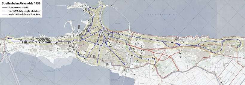
Alexandria’s Tram network in 1959 © Maximilian Dörrbecker (Chumwa) and licensed for reuse under a Creative Commons licence (CC BY-SA 3.0). [13]
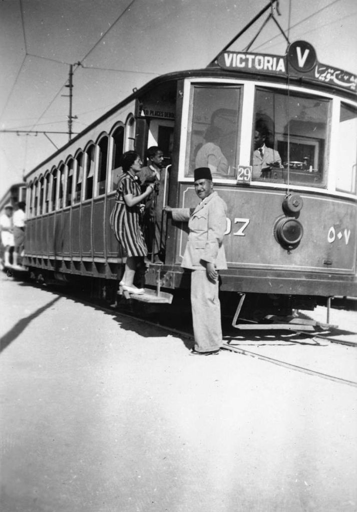
Alexandria Tram in the 1940s © foundin_a_attic and licensed for reuse under a Creative Commons licence (CC BY 2.0). [13]
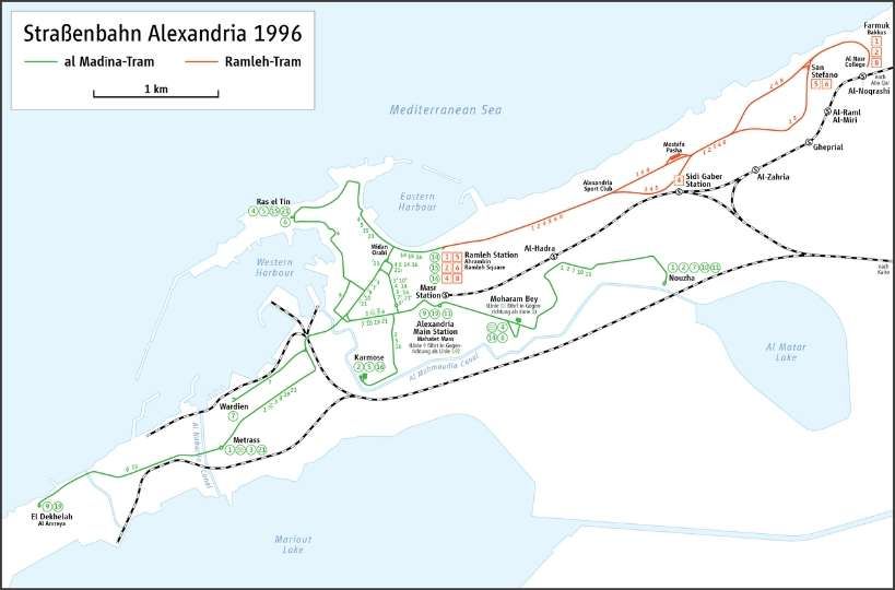
Alexandria tramway routes in 1996, © Maximilian Dörrbecker (Chumwa) and licensed for reuse under a Creative Commons licence (CC BY-SA 3.0). [13]

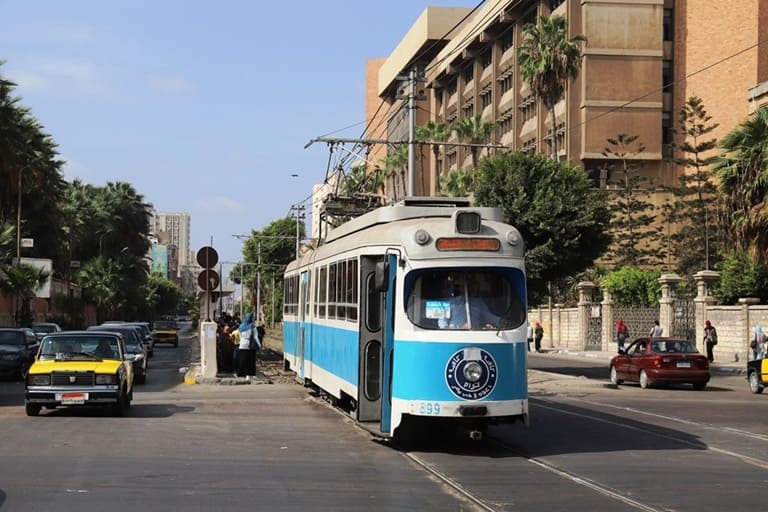
Egypt’s major tram modernization focuses on the historic Al Raml tramway in Alexandria, which suspended operations on 1st April 2026. Managed by the National Authority for Tunnels (NAT), the €236 million overhaul converts the 14.1 km heritage line into a fast, digitally controlled light rail system slated to finish by late 2028. [10]
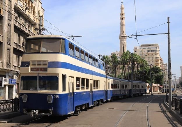
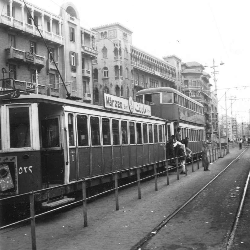
Until its closure, Alexandria — alongside Hong Kong and Blackpool — was one of the last tram systems worldwide to operate double-decker trams in regular service. This chapter has now come to an end, © UTM. [11]
Alexandria’s Trams in 1969: a double-decker tram is part of the consist shown here, © FOTO:FORTEPAN/Gyöngyi and licensed for reuse under a Creative Commons licence (CC BY-SA 3.0). [13]
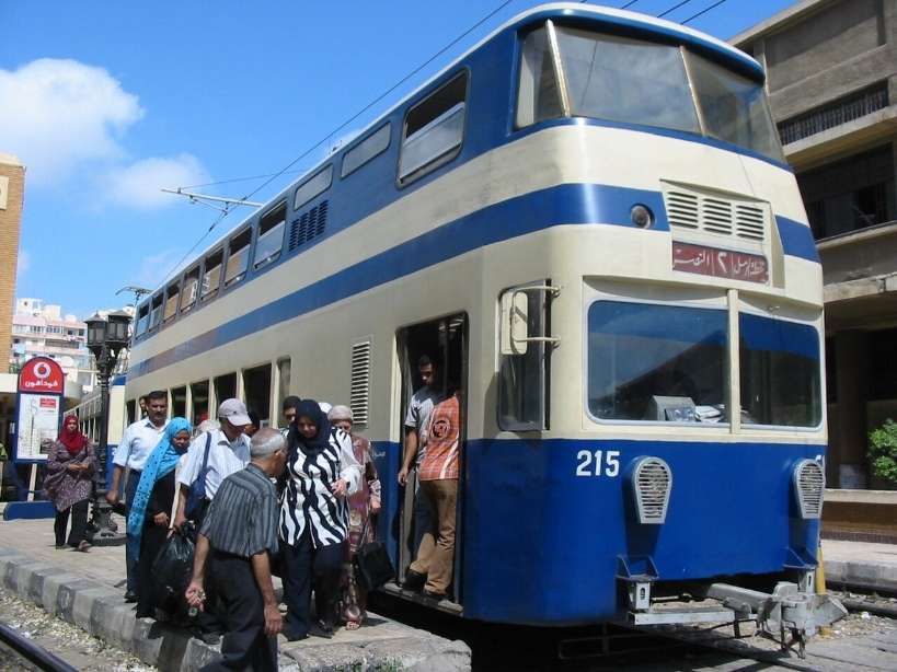
One of the small number of double-deck cars (from Kinki Sharyo) in Alexandria’s fleet. All six are non-motorised control trailers, photo taken in 2008, © Wrightbus and licensed for reuse under a Creative Commons (CC BY 3.0). [13]

Hitachi Rail has secured a contract to deliver the rail systems and digital technologies that will modernise and upgrade the Alexandria Raml Tram – the first modern tramway project of its kind in Egypt. The contract was awarded by the Hassan Allam Construction and Arab Contractors joint venture and will significantly improve speed, capacity and reliability on one of the world’s oldest continuously operating tram systems. [10]

The Alexandria El Raml Tram is the oldest tramline in the Middle East and Africa, dating back to 1863. Despite its age and limited modernisation since the 1960s, it remains one of the few tramways globally to operate double-deck vehicles in regular service. The new contract marks a major step in the line’s transformation. [10]

Under the agreement, Hitachi Rail will supply advanced signalling and communications systems, a modern Operational Control Centre, SCADA, CCTV and access control, passenger information systems, and on-board equipment. Together, these systems will help deliver a faster, safer and more efficient public transport service aligned with Egypt’s Vision 2030 goals for sustainable mobility. [10]

The modernisation programme includes the reconstruction of 24 stations and 13.2 km of track. Once completed, the new system will:

  • reduce travel time from 60 to 35 minutes
  • double operational speed from 11 km/h to 21 km/h
  • cut headways from 9 minutes to 3 minutes
  • increase capacity from 4,700 to 13,800 passengers per hour per direction

This capacity boost will ease congestion, support modal shift and reduce CO₂ emissions while improving daily mobility across Alexandria. [10]

The El Raml Tram upgrade represents a significant milestone for Hitachi Rail’s growing presence in Egypt’s rail and metro sector. The company is already involved in key national programmes, including the Greater Cairo metro network, the LRT and monorail systems, and AFC modernisation initiatives. [10]

Hitachi Rail continues to expand its local footprint through engineering, financial, legal and operational teams established in Egypt. The company has increased localisation of IVVQ activities for CBTC systems and developed automated fare collection (AFC) projects that promote high-tech employment and diversity. These align with Egypt’s industrial and economic development priorities.[10]

Digital passenger information and multimodal payment systems are becoming central to Hitachi Rail’s offering in the region. For example, the upcoming Abu Qir Metro in Alexandria will integrate TRANSCITY™ AFC, enabling payments via QR codes, contactless cards, EMV bank cards and NFC mobile devices. [10]

The contract will see us modernize and upgrade the oldest electric tram system in Africa, transforming it into a reliable, efficient, and digitally enhanced transportation system. The project underlines the capabilities of Hitachi Rail technologies in the rehabilitation and modernization of tramway systems,” Carlo Piacenza, SRS MEA Regional Director, Hitachi Rail, said. [10]

Urban Transport Magazine reported in April 2026 that, “with the closure of the long-established Ramleh tramway, Alexandria is currently undergoing one of the most radical system transformations in urban rail transport in North Africa. The project exemplifies a global trend: replacing historically evolved tramway systems with higher-capacity light rail infrastructure — and the associated trade-offs.” [11]

Alexandria’s tramway network is among the oldest in the world: opened as early as 1863 and electrified from 1902, the Ramleh line in particular developed into one of the city’s most important east–west corridors. With around 80,000 passengers per day and a route length of approximately 32 km, it was a central component of the urban transport system. [11]

At the same time, the system suffered from decades of underinvestment. Low average speeds of around 11 km/h, ageing infrastructure and limited reliability significantly constrained its performance. Against the backdrop of increasing congestion and ongoing urbanisation, comprehensive modernisation gradually moved to the forefront of transport policy. [11]

Until its closure, operations on the Ramleh tramway were characterised by a remarkably heterogeneous and ageing fleet. The core of the services was provided by modernised vehicles from Kinki Sharyo, complemented by locally Tatra Yug units. In addition, a number of second-hand high-floor trams originally built by Düwag in the 1960s and acquired from Copenhagen remained in service. This mix of vehicles from different generations and technical standards reflected both the long operational history of the line and the prolonged lack of fleet renewal, resulting in increasing maintenance complexity and declining reliability in the final years of operation. [11]
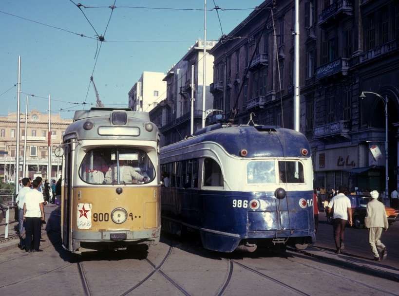
Alexandria Trams in 1974: An ex-Copenhagen tram on the left passing an ex-Toronto PCC tram. Car 900, on the left, is a Düwag GT6, ex-Københavns Sporveje number 900, © Kurt Rasmussen (Public Domain). [13]
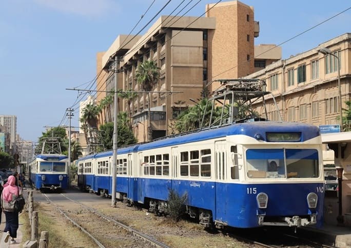
Two Kinki Sharyo tramsets, largely identical to those formerly used on the now-closed Heliopolis tramway in Cairo, operating on a segregated right-of-way, © UTM. [11]
The Ramleh tram already operated largely on a segregated right-of-way, which is now set to be partially replaced by viaducts — a proposal that has raised eyebrows among transport experts, © UTM. [11]

The transition to the new system began in early 2026 with a phased shutdown. Following initial restrictions in February, operations were completely suspended on 1 April 2026. Since then, the existing infrastructure — including tracks, power supply and stops — has been undergoing comprehensive dismantling. The complete interruption of services represents a deliberate break with historical continuity, in contrast to many European modernisation projects, where upgrades are often carried out while operations continue. [11]

In place of the conventional tramway, a modern light rail system with significantly altered parameters is being developed. Approximately 13 km of the route will be fundamentally upgraded and partially realigned. [11]

Key elements include:

  • Increase in average speed from 11 to around 21 km/h
  • Reduced stop density (approximately 500 m spacing)
  • Modern signalling and control systems
  • Introduction of 30 high-capacity vehicles (Hyundai Rotem)

The project is thus clearly aimed at increasing capacity and efficiency, and conceptually aligns more closely with light rail or metro systems than with traditional tramways. [11]

Since early 2026, operations on the Ramleh tramway have been gradually wound down: following initial test closures in February, partial suspension began on 11th February, before services were fully discontinued on 1st April 2026. [11]

In the weeks leading up to this, the network saw something of a series of “farewell runs”, before the final trams ceased operation in early April. In parallel with the closure, comprehensive dismantling of the infrastructure began, including tracks, overhead lines and, in some cases, adjacent urban spaces. [11]

The transformation has met with considerable criticism in Alexandria and is the subject of intense public debate. While the government presents the project as a necessary step towards modernisation to increase capacity and speed, many residents view it as a profound intervention in the city’s historic urban fabric. [11]

A central point of criticism is the planned elevation of the route. More than half of the future line, which will be around 13 km long, is to run on viaducts. Critics fear that the existing tree-lined right-of-way will be replaced by “concrete stilts”, leading to a loss of the city’s characteristic urban landscape. [11]

Furthermore, it is argued that the shift towards a faster system, more strongly segregated from general traffic, may bring operational advantages but could come at the expense of urban integration. Urban planners warn that the new infrastructure is geared more towards throughput and speed, and less towards public realm quality and local accessibility. [11]

Transport impacts have also been viewed critically: even during the construction phase, the suspension of services has exacerbated traffic problems, as replacement services have only been able to compensate for demand to a limited extent. Some observers see this as an indication that, in the short term, the transformation could even lead to increased reliance on private motorised transport. [11]

Finally, the loss of cultural heritage plays a central role in the public debate. For many residents, the tramway is not merely a mode of transport, but an integral part of the city’s identity. Critics therefore speak of a tension between modernisation and “cultural dislocation”. [11]

Reopening is scheduled for the end of 2027. Whether the new system will meet expectations in terms of performance and attractiveness will depend largely on how successfully operational efficiency can be balanced with urban integration. [11]

Cairo’s Metro:

As of 2024, Cairo’s Metro has 84 stations of which 5 are transfer stations, with a total length of 106.8 kilometres (66.4 mi). The system consists of three operational lines numbered 1 to 3. It is part of an integrated transport network.
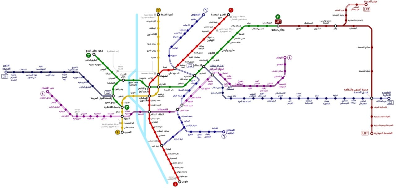
Map of Cairo Metro, LRT, and Monorail lines. Thick lines indicate lines in operation and hollow lines indicate lines under construction or in planning, (c) BasilLeaf and licensed for reuse under a Creative Commons licence, (CC BY-SA 4.0). [12]

As the biggest and most densely populated megacity in Africa and the Middle East, Greater Cairo had a strong case for a metro. In 1987 that population stood at 10 million residents, not counting the two million or so commuters who came into Cairo every day to work. The capacity of Cairo’s public transport infrastructure was around 20,000 passengers/hour, which increased to 60,000 after the construction of the metro. [13]

In the 2020s, “Cairo has more than 20 million people in its metropolitan area, and the chaos on the surface can be disorientating for anyone arriving for the first time: gridlock that stretches for kilometres, constant horns, intersections that follow no obvious logic. But beneath all that noise there is a system that organises the movement of millions of people every day. The Cairo Metro — officially the Cairo Metro or مترو القاهرة — is the backbone of public transport in this megalopolis, the first metro ever built in Africa, and the first in the entire Arab world.” [14]
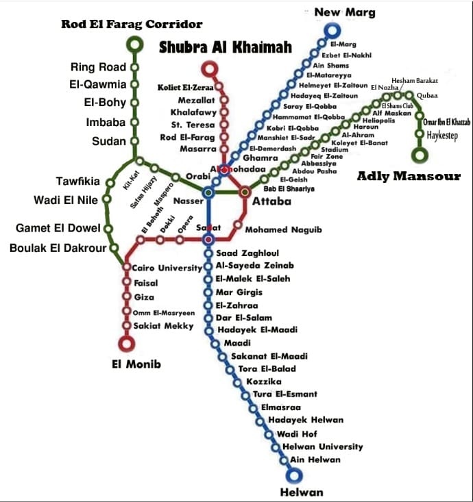
In 2023, Cairo Metro carried 1,460 million passengers, which works out to around 5 million journeys a day — a figure that puts it among the most heavily used metro systems in Africa and the Arab world. For most of its passengers, the metro is not an alternative to other options; it is the only realistic way to cross the city in a reasonable amount of time. [14]

What makes this system distinctive is not only its history but its composition. Line 1 was born from the conversion of existing suburban railway corridors, combining surface sections with a few kilometres of tunnel through the historic heart of the city. Line 2 was a first for the continent: it crosses the Nile through a tunnel, the first railway tunnel under that river anywhere in Africa, a genuinely complex engineering achievement. Line 3, the most modern, was under construction in phases for over a decade and represents the biggest technological step forward in the system, with better stations and newer trains. It was completed in 2024. [14]

For travellers arriving in Cairo, the Metro is an indispensable tool for connecting the historic centre with modern districts, Ramses train station and the main residential areas. At present, the Cairo Metro does not reach the Pyramids of Giza. [14]

The density of Greater Cairo makes any underground construction extraordinarily complicated. Several sections were built directly beneath narrow alleyways, centuries-old markets, multi-storey buildings and layers of pre-existing infrastructure. Expropriations in historic districts such as Khan El Khalili, or in densely populated residential neighbourhoods, required lengthy and costly negotiations. In some stretches engineers opted for cut-and-cover construction with minimal disruption; in the historic centre, tunnel-boring machines were the only viable approach. [14]

The system at present operates trains from different generations depending on the line.
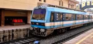
Line 1 still runs sets from the original era — nine-car trains with capacity for over 2,000 passengers, revised and upgraded over the decades. Some were refurbished by Hyundai in the early 2010s. [19] Others are being refurbished by Mitsubishi at present. [14][17]
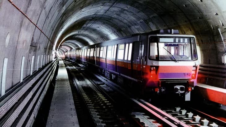
Line 2 has more modern stock acquired in the 1990s and early 2000s. [18] The National Authority for Tunnels has awarded CAF three contracts totalling more than €450m for the modernisation and maintenance of trainsets on Cairo Metro Line 2 and the maintenance of trainsets on Line 1. [14][20]
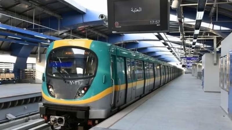
Line 3 works with the newest trains, some of them from contracts signed with Alstom in 2020/2021 for the supply of new Metropolis units. [14][21]

Line 4 connecting to Giza is under construction. The line is ultimaely intended to be 42 kilometres in length. [15] A first phase of 18-19 kilometres and between 15 and 17 stations planned, it will connect the El-Malek El-Saleh area with north-west Giza, bringing the Metro significantly closer to the Pyramids zone for the first time. The project includes lifts for passengers with disabilities and modern access management systems built into the original design. Opening is estimated at being in the first half of 2028. [14][16]

Phase 1 runs largely underground, serving 17 stations, from the boundary between Cairo and 6th of October City to Grand Egyptian Museum, Remaya Square, Haram Street, Giza Station, El-Malek El-Saleh and Fustat. Gewaily says that Line 4 will carry approximately 2 million passengers a day when completed. [16]
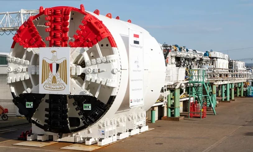
Four high-performance Herrenknecht tunnel boring machines were deployed for tunnel construction. They commenced excavation at the end of 2023 and the beginning of 2024, ensuring efficient and precise tunnelling under challenging geological conditions. [15]

Mitsubishi is supplying 23 trains for the line, the first of was scheduled for delivery In May 2026, construction of depot facilities and the installation of electromechanical systems. Civil works are being undertaken by domestic firms Arab Contractors, Orascom, Concord, Petrojet, and Hassan Allam Construction. [16]
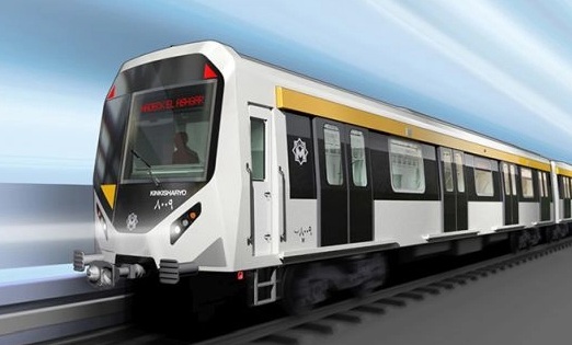
A Mitsubishi Kinki Sharyo train manufactured for the Cairo Metro Line 4. Phase 1 of Line 4 is scheduled to open in the first half of 2028.The contract includes supplying 184 metro cars to be delivered between 2026 and 2028.The trainsets are being shipped from Kobe, Japan, to Alexandria, Egypt. [16]

The government is currently considering three further phases for Line 4:

Phase 2: Fustat – New Cairo
Phase 3: Hadaeq El Ashgar – Hosary Square, and
Phase 4: New Cairo – the Capital Airport. [16]

The extended line will provide interchange with the planned metro Line 6, the Light Rail Transit (LRT) network and both the East of Nile and West of Nile monorail lines. [16]

Also planned is an extension to Line 3 to reach Cairo International Airport. It will add roughly 7 kilometres and 5 new stations from the Heliopolis area to the airport terminal. As of mid-2026 there is no confirmed opening date: the project has been announced on several occasions, but financing and timescales are not yet settled. [16]

Line 5 and Line 6 and the long-term network. The Greater Cairo master plan envisages a network of up to six metro lines plus complementary systems including the monorail, long-distance high-speed rail and extensions to the new satellite cities. Line 6 is planned to connect Shubra with Maadi, providing a new north-south axis that takes pressure off Line 1. All of these projects extend beyond 2030. [16]

References

  1. Solomon Ekanem; Africa’s longest monorail line begins operations as Egypt opens 56.5km Cairo route; in Business Insider Africa, 21st March 2026; via https://africa.businessinsider.com/local/lifestyle/africas-longest-monorail-line-begins-operations-as-egypt-opens-565km-cairo-route/n64xvkw, accessed on 22nd March 2026.
  2. https://www.egypttoday.com/Article/1/145804/East-Nile-monorail-begins-operations-linking-Cairo-to-New-Capital, accessed on 22nd March 2026.
  3. https://www.linkedin.com/feed/update/urn:li:activity:6881253143993204736, accessed on 22nd March 2026.
  4. https://en.wikipedia.org/wiki/Cairo_Monorail, accessed on 22nd March 2026.
  5. https://www.railwaygazette.com/infrastructure/cairo-to-alexandria-railway-modernised-to-increase-speed-and-capacity/69588.article, accessed on 22nd March 2026.
  6. https://www.travelmole.com/news/egypt-showcases-its-new-high-speed-train, accessed on 22nd March 2026.
  7. https://en.wikipedia.org/wiki/Egyptian_National_Railways, accessed on 22nd March 2026.
  8. https://www.railwaygazette.com/category/egypt, accessed on 19th July 2026.
  9. https://rogerfarnworth.com/2026/04/01/egyptian-railway-history-a-short-version/
  10. https://www.railwaypro.com/wp/hitachi-rail-to-modernise-egypts-historic-alexandria-tram, accessed on 28th July 2026.
  11. https://www.urban-transport-magazine.com/en/alexandria-system-transition-of-the-ramleh-tram-between-modernisation-and-the-loss-of-urban-identity, accessed on 28th July 2026.
  12. https://upload.wikimedia.org/wikipedia/commons/6/6e/Cairo_Rapid_Transit_map.png, accessed on 28th July 2026.
  13. https://en.wikipedia.org/wiki/Cairo_Metro, accessed on 28th July 2026.
  14. https://mapa-metro.com/en/egypt/cairo/cairo-metro-map.htm, accessed on 29th July 2026.
  15. https://www.herrenknecht.com/en/references/referencesdetail/cairo-metro-line-4, accessed on 29th July 2026.
  16. https://www.railjournal.com/passenger/metros/cairo-metro-line-4-opening-announced, accessed on 29th July 2026.
  17. https://www.railwaypro.com/wp/caf-to-refurbish-cairo-metro-trains, accessed on 29th July 2026.
  18. https://www.herrenknecht.com/en/references/referencesdetail/cairo-metro-line-2, accessed on 29th July 2026.
  19. https://rollingstockworld.com/lrv/hyundai-rotem-finalized-a-contract-for-the-supply-of-40-metro-trains-for-cairo, accessed on 29th July 2026.
  20. https://www.railwaygazette.com/urban/2025/09/25/cairo-metro-train-modernisation-and-maintenance-contracts-awarded, accessed on 29th July 2026.
  21. https://www.railway-technology.com/news/cairo-metro-egypt-phase-4b-extension-of-line-3, accessed on 29th July 2026.
The Modern Tram Network in Nice 2023

Nice is a picturesque city nestled in the French Riviera. It is renowned for its stunning landscapes, vibrant culture, and rich history. In recent years, one of the most remarkable transformations in the city’s infrastructure has been the development and expansion of its modern tram network.

In November 2017, I wrote two short articles about the History of Trams in and around Nice and the development of modern trams in Nice.

https://wordpress.com/post/rogerfarnworth.com/2332

https://wordpress.com/post/rogerfarnworth.com/2342

After those two articles about the modern trams, further articles have explored the old first generation electric tramway network in and around Nice, extending to Cannes to the West, Menton to the East and into the hinterland North of the coast. All of these can be found on this blog under the Railways and Tramways tab, and then under ‘French Railways and Tramways’ … ‘Railways and Tramways Around Nice’. Indeed at the time of writing that series of articles continues to develop. The most recent articles have focussed on the coastal tramways between Cannes and Menton.

In November 2023, it seems to be a good time to review progress on the growing tram network in and around Nice, particularly since we would be staying in the area for 10 days.

The modern tram network in Nice has undergone significant development and expansion over the past few decades. The initial line, Line 1, was inaugurated in 2007 as part of a city-wide urban revitalization project. Since then, the network has expanded to include two more lines: Line 2, which opened in 2019, and Line 3, scheduled to be operational in the near future.

I asked ChatGPT to give me a short introduction to the modern tram network, this is what that AI software came up with:

The introduction of a modern tram network has had a profound formal impact on the cityscape of Nice. The sleek, contemporary design of the trams, characterized by clean lines and a bold colour scheme, seamlessly integrate with the city’s existing architecture. The tram tracks, which run through the heart of Nice, have been ingeniously incorporated into the urban fabric, enhancing the overall aesthetic appeal of the city. The tram stops, with their modern structures and vibrant lighting, serve as architectural landmarks, contributing to the city’s cosmopolitan image.

The modern tram network in Nice plays a vital role in ensuring efficient and accessible transportation for both residents and tourists. Trams in Nice are known for their punctuality, frequency, and reliability, allowing passengers to reach their destinations quickly and comfortably. With dedicated lanes and priority at traffic signals, trams efficiently navigate through the city, avoiding congestion and minimizing travel times. Furthermore, the accessibility of trams is commendable, with low floors, ample space for wheelchair users, and clearly marked priority seating, ensuring that everyone can travel with ease.

The modern tram network in Nice also brings substantial environmental benefits to the city. By encouraging the use of public transportation over private vehicles, the tram system helps reduce air pollution and carbon emissions. Additionally, the trams in Nice are electrically powered, relying on clean energy sources, which further contribute to a more sustainable and eco-friendly transportation system. This commitment to environmental stewardship aligns with the city’s dedication to creating a greener future.

Beyond its formal and functional impact, the modern tram network in Nice fosters social cohesion and urban integration. The trams serve as communal spaces, bringing together people from different walks of life into a shared mode of transportation. This enhances the sense of community and interaction among residents and visitors, contributing to a vibrant and inclusive urban environment. Moreover, the tram system connects various neighborhoods, enabling better access to education, employment opportunities, and cultural amenities, further promoting social and economic development.

The modern tram network in Nice has transformed the city, both in its physical appearance and its provision of efficient and sustainable transportation. With its formal integration, efficiency, accessibility, environmental advantages, and social cohesion, the tram system has become an invaluable asset for the city and its residents. As Nice continues to evolve, the tram network will undoubtedly play a crucial role in shaping the city’s future, ensuring that it remains a model of modernity and progress.”

…….. Chat GPT

A fine, and glowing, introduction to the tramway network but which says no more than any city might want to say as an introduction to the use of trams in its urban environment. Hopefully we can add considerably more specific detail relating to Nice’s tramway network.

First a reminder of the history of trams and tramways in Nice:

The first tramway in Nice opened in 1879, was electrified in 1900, and was followed by a departmental network in 1906. The entire network was electrified in 1910. In the 1920s, the network had 11 lines, some of which were partially used for goods transport. However, the tram was criticised and was replaced by buses on some lines beginning in 1927. The last tramway in Nice ceased service on 10 January 1953. ” [1]

The Developing Network

The Tramway de Nice is a 27.5-kilometre (17.1 mile), tramway in Nice. It is operated by the Société Nouvelle des Transports de l’Agglomération Niçoise, which is a division of Transdev. [2] The network operates under the name ‘Lignes d’Azur‘. [1]

The first line opened on 24th November 2007 and replaced bus lines 1, 2, 5 and 18. From the start, the system had 20 No. Alstom Citadis trams in service, providing a tram every seven minutes. Wikipedia states that “since its inception, the number of passengers has increased from 70,000 per day in 2008 to 90,000 per day in 2011. The frequency has gradually increased to a tram every four minutes in 2011.” [1]

The success of the trams resulted in the city authorities deciding to create additional lines. “The West-East T2 Line serves the Nice Côte d’Azur Airport to the West through the construction of a multimodal centre and the Port of Nice to the East. This line runs through a tunnel in the centre of Nice. A future extension of the West–East line, North along the Var valley, is proposed. Another extension, running further West from the airport, across the River Var, is also proposed. [3] In addition, the Nice authorities decided to extend Line 1 to the Pasteur neighbourhood.” [1]

The extension along the Var valley mentioned in the Wikipedia article is now, in 2023, operational as Ligne 3.

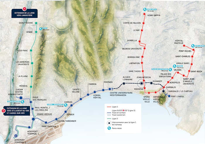
The Modern Tramway in Nice: Ligne 1 is shown in red; Ligne 2 in dark blue; and Ligne 3 in cyan. This is the network as it existed in November 2023 at the time of our visit. [3]

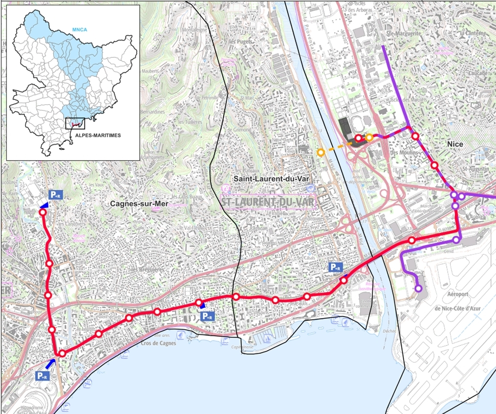
A further line, Ligne 4, is now under development with public consultation having taking place in October 2021 and archaeological investigation in St. Laurent-du-Var and Cagnes-sur-Mer undertaken between April and July 2023. [6]

The public inquiry for Ligne 4 was held in June and July 2023. [7] The proposed route is shown below. [8]

The Public Inquiry decided in favour of the creation of Ligne 4, with two reservations and one recommendation:

Reservation 1:

Boulevard Marechal Jean must be reconsidered, not as the route of the proposed line but in order to mitigate present congestion. Specifically, the authorities must: create shaded spaces; separate and reduce circulatory flows as much as possible for reasons of calm and safety; increase and promote as much space as possible reserved for pedestrians; use permeable surfacing; take advantage of the arrival of the tram to make Boulevard Marechal Juin attractive in order to revitalize businesses, professions and other activities. “The Commission, without calling into question the choice of route, requests that a new development proposal for Boulevard Maréchal Juin be submitted to public consultation at the most appropriate time.” [9]

Reservation 2:

Related to access provisions to one specific location, a clinic. The Commission required that, in addition to a ramp currently proposed, a suitable mechanised/motorised means of access from the tram stop to the clinic should be provided. [9]

Recommendation:

The current proposals only allow for one parking space for a funeral hearse for the Sainte Famille church in Cagnes-sur-Mer. The commission saw no reason why 4 such spaces could not be provided to give adequate provision for religious services without blocking the tramway. The commission also asked that the authorities give consideration to greater investment in the planned local park-and-ride provision to allow “the construction of underground parking lots, thus creating a landscaped public garden with an interesting perspective.” [9]

In the light of, often, protracted planning procedures in the UK, it is worth noting that the Inquiry finished towards the end of July and that the full report and summary report were published and available to the public by 7th September 2023, around 5 weeks after the closure of the Inquiry!

Looking further forward a fifth line is being considered. Ligne 5 will run from Drap to the eastern centre of the city of Nice.

A Focus on Ligne 1

On 27th May 2008, Railway Technology reported on the development of the first line which had opened in November 2007.

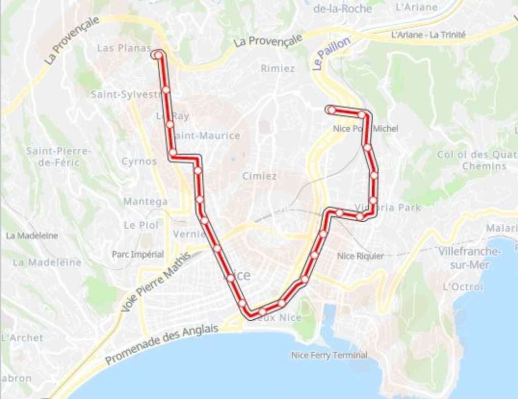
A map of Ligne 1. [24]

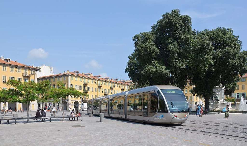
The system’s distinguishing technical feature is the use of batteries aboard the trams to avoid the necessity of erecting overhead line equipment (OHLE) on two sections of the route. This was felt necessary to protect the character of the distinctive Italianate architecture and also because of restrictions such structures would put in the way of Nice’s carnival processions, both relevant to the area’s substantial tourism industry.” [4]

Apparently, the relatively short distances involved lent substance to the belief that battery operation was was more appropriate than the alternative Alstom OHLE-free system, APS. That alternative system has been used in Bordeaux and was due to be installed on “systems in Angers, Reims, Orléans and the Al Safooh tramway in Dubai, the more elaborate Alimentation Par le Sol/APS (ground-supply) format requires specialised equipment aboard the vehicles and also in the permanent way.” [4]

There are sections of grassed tracks throughout the system and Nice took the opportunity to undertake significant reworking of space, excluding general traffic from specific areas which then became tram/pedestrian only areas. That possibility has also been embraced in the ongoing development of the different lines which make up the system in 2023.

The European Investment Bank made a €150m loan for the project which had a total cost of approximately €560m, of which just over 70% related to creating the tramway. Areas of expenditure indicative of the demands of the setting included storm water drainage works (€25m), rebuilding of Place Massena (€13m), public lighting (€4m) and tree planting (€1m).” [4]

At the time Railway Technology produced their article, they could write that, “The 8.7km double-track 1,435mm gauge line, with two brief sections where tracks diverge through narrow streets, forms a ‘U’ configuration, the two arms largely serving demand in residential areas and institutions. The base is near the southern end of the main thoroughfare Avenue Jean Médecin and the two open spaces near the Old Town, Place Masséna and Place Garibaldi, respectively 440m and 470m sections without OHLE. These ‘gaps’ are joined by a 320m section with OHLE between Opéra-Vieille-Ville and Cathédrale-Vieille-Ville stops where trams run conventionally.” [4]

Ligne 1, has only seen minor changes since it was first opened. Its western terminus is at Las Planas, and it is there that the line has its depot. “Built on sloping ground, the complex makes use of the restricted site by a line spiralling over the entry tracks beyond the Las Planas stop to give access to the depot proper and a short test track. Located close to the A8 autoroute, Las Planas also incorporates a park-and-ride facility.”

Its Eastern terminus was for some time at Pont Michel but an extension to Pasteur was completed in 2013.

Ligne 1 was initially supposed to transport 65,000 passengers/day. But it was quickly adopted by the people of Nice. Today, Ligne 1 can transport nearly 100,000 passengers/day and supports the ongoing development and attractiveness of the neighbourhoods it passes through. “Around 126,500 residents and more than 42,000 jobs, or 37% of Nice’s population and nearly a third of the city’s jobs, are less than 400 metres from the line. With 22 stations and a frequency of one tram every 4 minutes, Ligne 1 allows residents of the city to reduce their travel time.” [5]

An Atom Citadis Tram on Ligne 1, crossing Place Garibaldi in Nice. The tram uses onboard nickel metal hydride batteries to cross this and Place Masséna, © Mirabella and authorised for use under a Creative Commons Licence (CC BY-SA 3.0). [22]

At its opening, Ligne 1 was operated by a fleet of 20 No. 20 Alstom Citadis type 302 trams. “The fully air-conditioned, 100% low-floor, modular five-unit double-ended trams could be extended in response to the high take-up of the service. Roof-mounted Ni-MH (nickel-metal hydride) traction batteries with an operational life of at least five years were supplied by Saft under a €2m contract, giving trams a range of up to 1km at a maximum speed of 30km/h with air-conditioning in operation, the switching of power being either from the overhead line or the batteries is activated by the driver, with the pantograph fully lowered when running without OHLE.” [4]

Each tram’s driver console features visual and audio indications of the need to operate the power changeover sequence. The batteries recharge from the overhead supply while in conventional operation. There is no additional external infrastructure needed to operate the trams under battery power over the OHLE-free track.” [4]

The approximate Ligne 1 end-to-end journey time is 30min. “The control centre is at the depot, linked with trams and to the extensive network of video monitoring of the system. Benefiting from road traffic exclusions and priority at crossings, in this totally urban setting, trams can attain an average 18km/h, as opposed to 11km/h for buses.” [4]

The approximate Ligne 1 end-to-end journey time is 30min. “The control centre is at the depot, linked with trams and to the extensive network of video monitoring of the system. Benefiting from road traffic exclusions and priority at crossings, in this totally urban setting, trams can attain an average 18km/h, as opposed to 11km/h for buses.” [4]

A Focus on Ligne 2

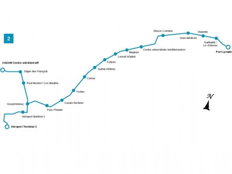
Ligne 2 connects the Airport with Nice’s Port Lympia, traversing central Nice. It connects with Ligne 1 at Avenue Jean Medecin and at Place Garibaldi.

A plan of Ligne 2, Nice. [25]

Following the success of tram Ligne 1, the mayor of Nice, Jacques Peyrat, decided to create a new line crossing Nice from east to west. This line would make it possible to serve the entire western district of the city which represents around 200,000 people, to transport more passengers (around 105,000) than with buses (around 70,000) as well as to reduce road traffic.

Between 2007 and 2008 a dedicated bus route to the Airport was provided, but the election of  Christian Estrosi as Mayor in March 2008 put an end to that project. [18]

On 25th June 2008, “Christian Estrosi announced that Ligne 2 would be built on the Promenade des Anglais, which would have made it possible to reduce costs and build the line more quickly as there would have been little or no traffic preparatory work to be done. The trams would have to be powered from the ground in order to prevent an overhead line damaging the view.” [18]

The controversial project along the Promenade was finally abandoned when on 9th October 2009, the mayor of Nice announced that Ligne 2 of the tramway would be built through the city, abandoning the route along Promenade des Anglais. The revised project meant that Ligne 2 would be 8.6 km long, including 3.6 km in tunnel. on the surface, the line would serve Nice-Côte d’Azur airport, the planned Saint-Augustin multimodal station (connection with the SNCF, the future TGV and the future tram Ligne 3) then would pass through Avenue René-Cassin, Avenue de la Californie and Rue de France. From the intersection with Boulevard François Grosso, the route would run underground with the stations Alsace-Lorraine, Musiciens, Place Wilson (near the future new town hall of Nice), Garibaldi, Île de Beauté (Port of Nice ) and Place Arson. The route would then return to the surface as far as a terminus at Nice-Riquier SNCF station.” [18]

The intention was for the work to be completed in 2016:

2013: construction of the tunnel in the city centre.

2016: commissioning of line 2 from Saint-Augustin to the port.

The Public Inquiry took place in December 2011 and January 2012 and some changes were made to the scheme as a result. These included:

  • The Eastern terminus being placed on the Cassini Quay at the Port.
  • A new stop being included at Sainte Helene.
  • Compensation being made available to traders affected by construction work.

In 2013, the line was divided into two sections. The first part between CADAM, Magnan and the Airport was given a target completion date of 2017, the remainder was scheduled for completion by 2019. [18]

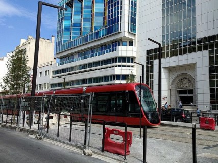
Tramway Ligne 2 Nice during final trials at the end of the on-street construction phase, © Jesmar and included here under a Creative Commons Licence (CC BY-SA 4.0 DEED). [25]

As the scheme developed the programme had to be amended. In June 2018, the length of the line between Magnan and CADAM was opened; in December 20th18, the length between Grand Arenas and the Airport terminal was completed; in June 2019 the length between Magnan and Avenue Jean Medecin was commissioned; and the final length to Port Lympia opened in December 2019. [18]

The cost of the work was estimated at 770.7 million euros, including 758.7 million euros for the work defined in 2009 and 12 million euros to cover modifications made by the public inquiry. This was financed by: the State (52.8 million); the general council of Alpes-Maritimes (50 million); the regional council of Provence-Alpes-Côte d’Azur (26 million); the European Regional Development Fund (3 million); and the airport company (between 10.2 and 12.6 million); the city of Nice (50 million); the General Investment Commission (4.69 million for rolling stock purchase); a loan from the European Investment Bank (250 million); and a loan from the city’s deposit and consignment fund (250 million). [18]

A New Depot

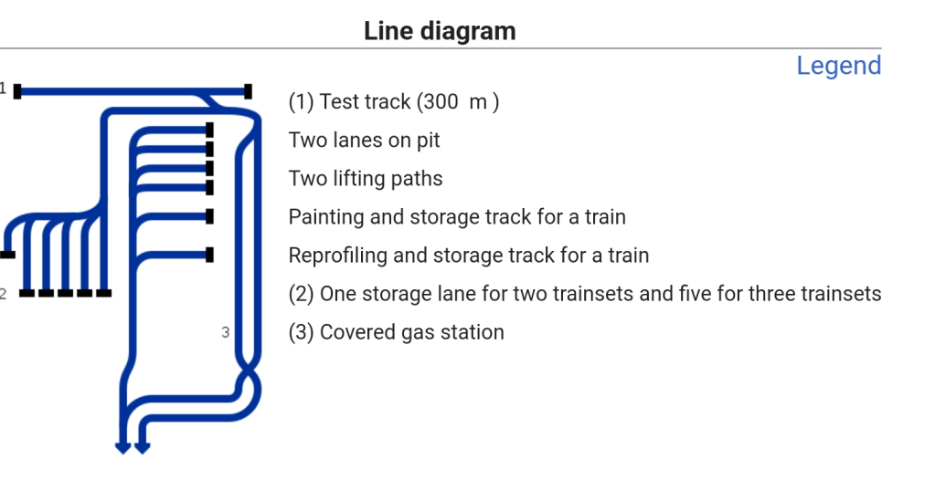
A new depot was built for Ligne 2 alongside the Ligne 1 depot at Henri Sappia.

A schematic plan of the new depot. The storage lanes are to the left of the diagram, numbered ‘2’ in the legend. [18]

The Henri Sappia depot is too small to accommodate all the trains from Ligne 1 and Ligne 2 simultaneously, a new depot has been built next to it. It is also the operational centre for the line. It is located between the A8 motorway and the Nikaia Palace with a total area of approximately 40,000 s². It is large enough to accommodate the 44 m trams of Ligne 2 as well as Ligne 3 and the future Ligne 4, around sixty. It is made up of a maintenance workshop, a storage centre of 2,860 m², a centralized control station of 130 s² and parking for two hundred and fifty vehicles. [18]

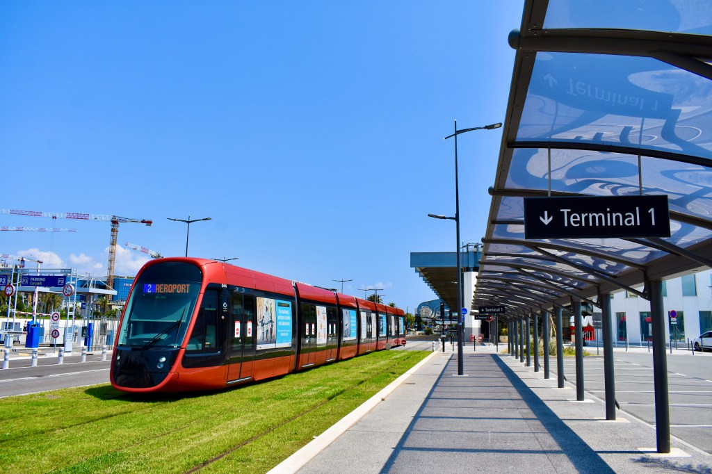
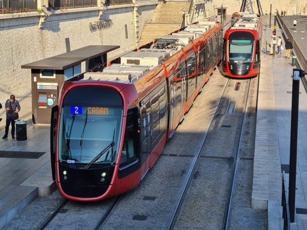
Ligne 2 Alstom Citadis X05 Tram at Nice Airport, © Snoopy 31 and used under a Creative Commons Licence (CC BY-SA 4.0 DEED). [23]

The Trams

Alstom Citadis X05 trams are in use on Ligne 2. Unlike Ligne 1, the new tramway does not feature overhead contact lines on the entire surface section of the route. This option was requested by the Nice Côte d’Azur Metropole to integrate the new tramway line into the urban landscape while preserving the city’s architecture. Instead, the line has been installed with intermittent charging in stations. [20]

Alstom supplied its latest ground-based static charging technology, SRS, which allows a tram to charge safely and automatically in under 20 seconds while stopped at a tram stop. The trams are equipped with an on-board energy storage device, Citadis Ecopack. Equipped with this technology, trams can charge up at each station as passengers get on and off, without extra stopping time and without driver intervention. [20]

Citadis X05 trams incorporate new technologies designed for lower energy consumption. The vehicles incorporate a 100% low-floor design. They have balcony-style windows, multi-purpose areas, LED lighting, CCTV cameras, emergency intercoms, electrical braking, permanent magnet motors and sensor-based air-conditioning. [21]

Heating, ventilation, and air conditioning (HVAC) systems installed in the trams contain separate controls for passengers and driver zones. Each bogie offers a 750mm-wide central aisle. The entrance height of the intermediate front doors is 326mm and 342mm. The trams’ crash absorption resistance complies with the EN15227 standards. [21]

Each motorised bogie of the vehicle is fitted with two air-cooled permanent magnet traction motors. They provide a maximum acceleration of 1.3m/s² and permit deceleration of 1.2m/s², while the compression load is 400kN. [21]

The contract with Alstom was worth €91m and covered the delivery of 19 Citadis X05 trams and all necessary land-based static charging points. The contract also includes options for up to 18 further trams and associated energy charging systems and maintenance services. [21]

A Focus on Ligne 3 …

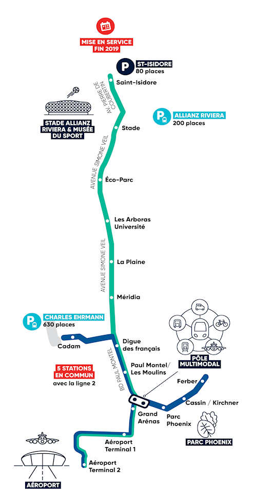
Ligne 3 connects the Airport with Saint Isidore, stopping at Allianz, Nice’s sports stadium. It connects with Ligne 2 at the airport, Grand Arenas, Paul Montel and Digue des Francais.

A route plan of Ligne 3 which runs North-South along the valley of the River Var. [26]

Ligne 3 is 7km long in total, stretching from Terminal 2 at Nice Airport to the heart of the Saint-Isidore district, North along the valley of the River Var. It has 11 stations in total including 5 stations in common with the West-East line. Trams travel at an average speed of 22km/hr. 12,000 passengers per day is the average usage. Trams run at a Frequency of 10 minutes and 6 trams are dedicated to the line. Additional trams are operated on march days or events and on these days a frequency of 3 minutes is sustained. It is predicted that by 2026 25,000 jobs, 11,400 inhabitants and 5,400 new homes will be served by the line. [27]

In 2017, the route Ligne 3 was finalised by the authorities. The work had an estimated cost of 56.3 million euros excluding taxes, partly subsidized by the State (3.5 million), the region (8 million), the department ( 4 million) and the city (15 million). Construction work began on 19th March 2018 and the line opened in full on 13th November 2019. [28]

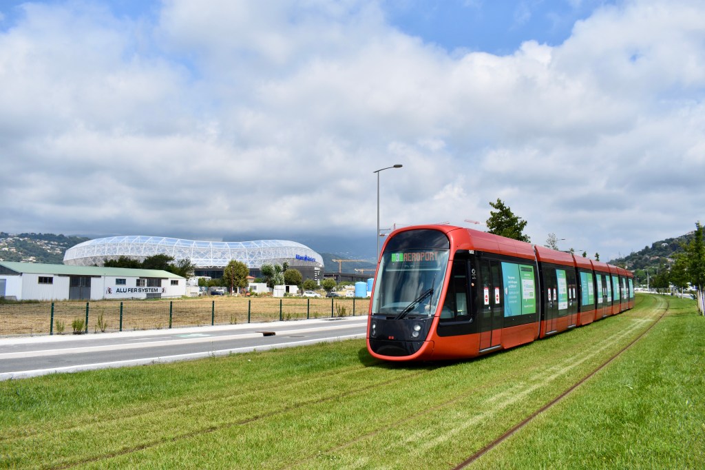
An Alstom Citadis X05 Tram on Ligne 3 with the Alliance Riviera Stadium in the background, © Snoopy 31 and used under a Creative Commons Licence (CC BY-SA 4.0 DEED). [28]

At the end of 2019, 6 additional tram sets were put into service to allow the operation of Ligne 3. These were identical to the trams in use on Ligne 2 and are powered in the same way as the Ligne 2 trams, operating without overhead contact lines.

The Charles Ginésy maintenance centre was established as part of the construction work. It is located at the Charles Ehrmann sports park and now is common to both Ligne 2 and Ligne 3, It has been designed to accommodate and maintain the whole fleet of trams on the two lines. [27]

New park-and-ride facilities accommodate 630 vehicles.

A Focus on Ligne 4 …

The city of Nice believes that the ongoing development of the tram network brings significant benefits which are focussed in 3 main areas: [10]

  • Mobility: facilitating travel thanks to the tramway and cycle paths, creating new park and ride facilities, increasing intermodality, ensuring a quality, regular service to the sectors crossed,
  • Quality of life : a reclassified living environment, less pollution and less noise, less car traffic, a more beautiful and peaceful city, more modern and green,
  • Economic development: a more attractive city that encourages activity, a mobility offer superior to current trips to shops and businesses, a saving on travel costs, job creation during the construction phase.

Ligne 4 “will connect the three most important municipalities in the Metropolis in terms of population and jobs: Nice, Saint-Laurent-du-Var and Cagnes-sur-Mer. It will serve 18 stations, including 14 new ones, over a length of 7.1 km of track created, supplemented by 4 new park-and-ride facilities comprising 1,200 spaces (Saint-Laurent-du-Var station, Val Fleuri, Hippodrome, Parc des sports of Cagnes-sur-Mer). Thus, 40,000 passengers will be transported every day, calming traffic and avoiding 4,500 tonnes of greenhouse gas emissions per year from 2028.” [7]

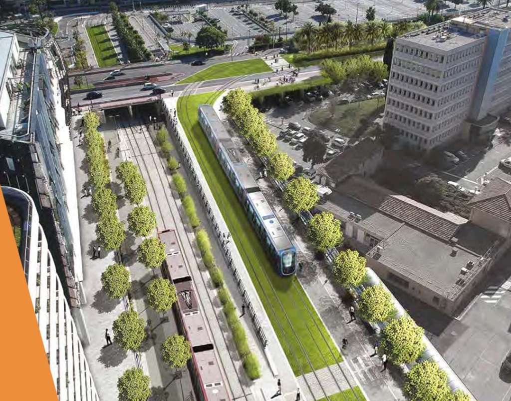
A bird’s eye view of the proposed Ligne 4 with the Line 2 route to the Airport on the left. [12]
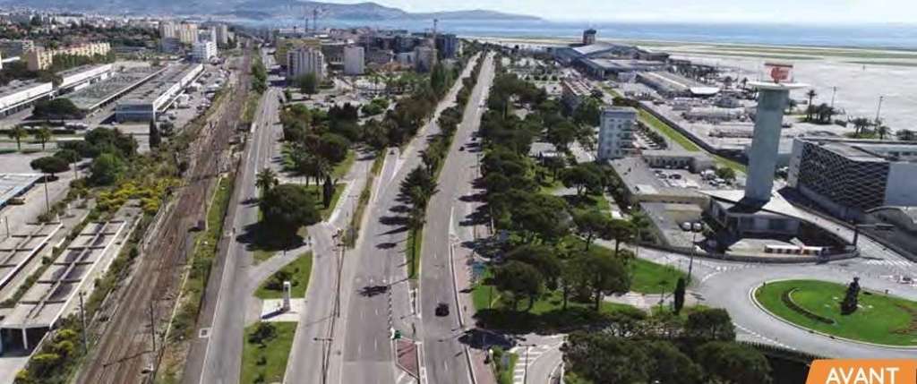
Before and After aerial images associated with the planned construction of Ligne 4, showing the area outside the boundary of Nice Airport. [12]

This line will be accompanied by the planting of 1,160 trees and the preservation of 365 trees along the route and 30,000 m² of green tramway.

The route will run from the CADAM (administrative center) in St. Laurent-du-Var to the Cagnes-sur-Mer Sports Park.

St. Laurent-du-Var as it will probably look from the air after completion of Ligne 4. [13]

A Focus on Ligne 5 …

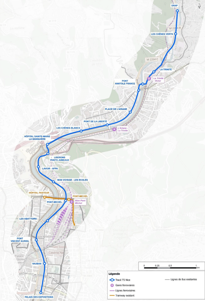
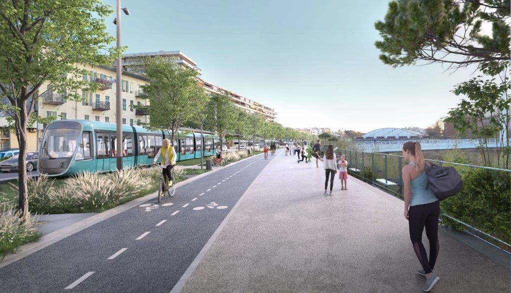
As part of the creation of this new transport axis, it is planned, in addition to the creation of 7.6 km of additional tramway on predominantly grassed trackway tram platform,, to give more space to pedestrians and bicycles. Thus, a continuous cycle route will be created between Drap and the eastern centre of Nice. More generous pedestrian spaces will be created along this axis to rebalance the city for the benefit of local residents.” [10]

Like the other lines, the entire route will be accessible to all. Developments will be made on and around the stations to guarantee all people benefit from its presence. In the light of this additional and improved pedestrian crossing points over the River Paillon will be created specifically at two locations where tram stations will sit on significantly widened bridges: Pont Jumeaux and Pont Anatole France, which are not very accessible to pedestrians today. The objective is to encourage pedestrian crossing of the Paillon by giving more dedicated space.

Pont Anatole France station is a good example of this desire to connect the two banks. This station will be located on the bridge and will therefore be easily accessible from both banks via generous spaces for pedestrians.” [10]

The proposed route of Ligne 5. It extends from the station of the future Palais des Arts et de la Culture (now the Palais des Expositions) in Nice to Drap Town Hall. 7.6 km in all The proposed route will need to be refined and confirmed, in particular by collecting public opinion. The positioning of the tram stops may change. A series of superb visuals were produced during early development work and these can be found here. [11]

Ligne 5 could have been envisaged as an extension to Ligne 1, indeed it was seen as an extension in very early considerations for a tram network in Nice. However, Ligne 1 is acting a full capacity and would require significant alteration to accommodate the additional traffic produced by an extension to Drap.

In the light of this Ligne 5 is intended to be independent of Ligne 1 with its own terminus at the Palais des Expositions. By deviating from the route of Ligne 1, Ligne 5 includes “new  neighbourhoods and both banks of the Paillon.” [10] It will, however, be “interconnected with Ligne 1 at Pont-Michel, so that Ligne 5 trams can reach the maintenance centre in Nice-Nord.” [10]

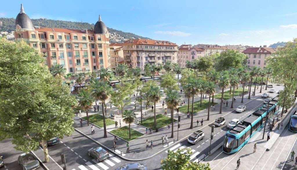
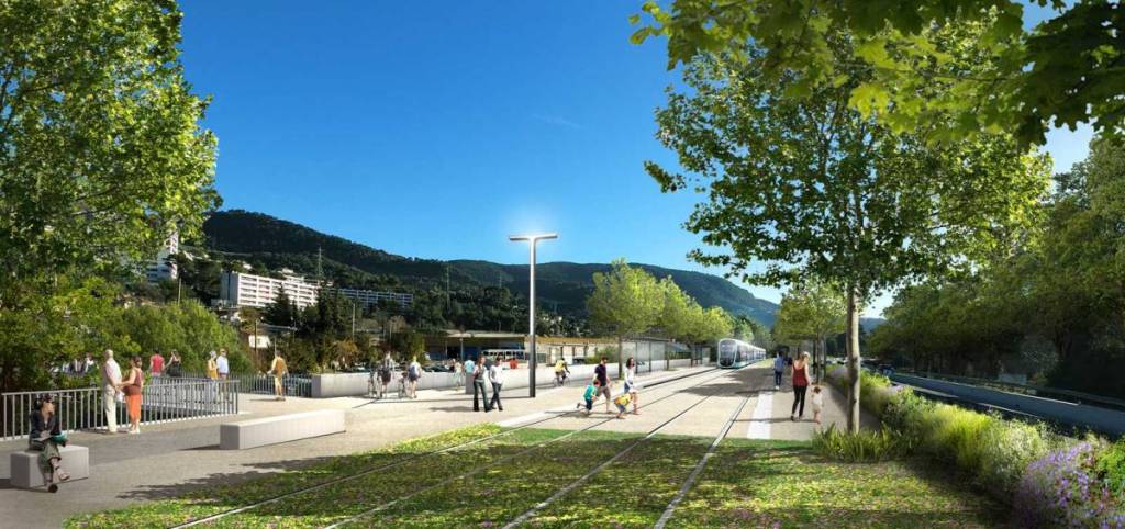
An artist’s impression of Ligne 5 at Pont St. Michel. [19]
A ‘possible’ Bird’s eye view of Ligne 1 and Ligne 5 at Place de l’Armee du Rhin after completion of Ligne 5. [11]
An artists impression of Ligne 5 on Boulevard Vérany and the banks of the River Paillon. [11]
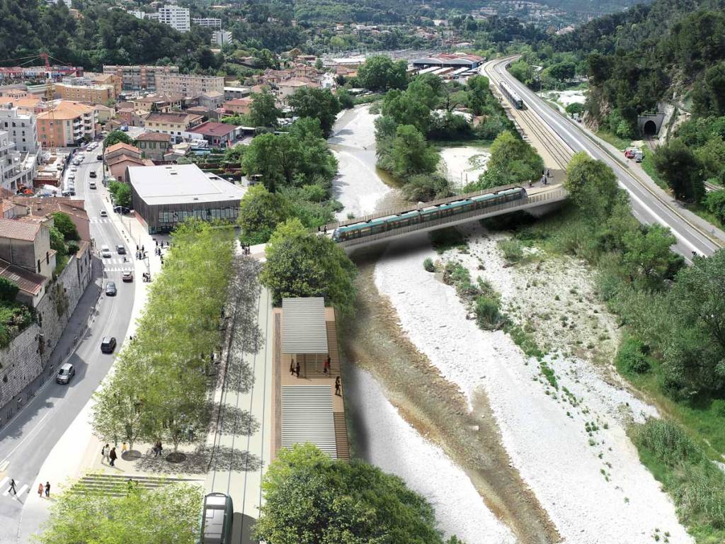
Two trams are shown in this artist’s impression of the Pont Jumeaux crossing of the River Paillon with its adjacent tram stop. [11]
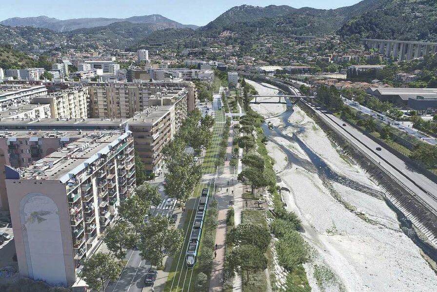
Another aerial view, this time showing a tram on the proposed route along Boulevard de l’Ariane and the banks of the River Paillon looking towards the hills. [11]
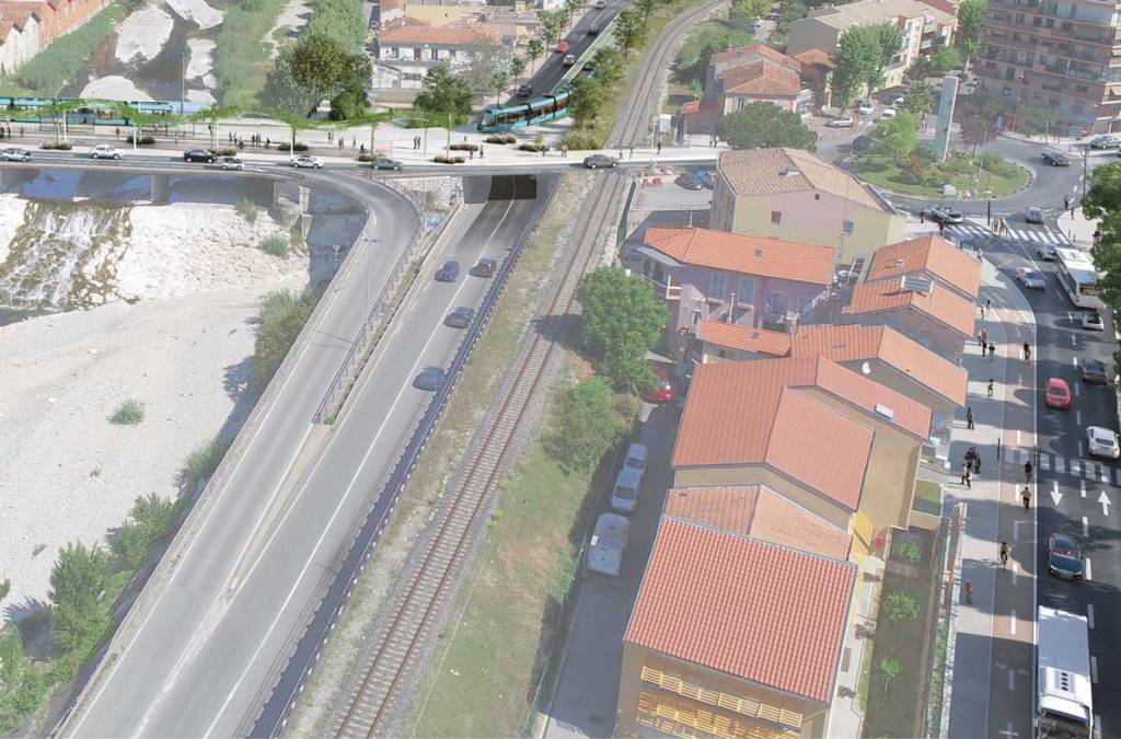
La Trinité – A tram crossing the River Paillon on Pont Anatole France through the proposed tram stop. [11]
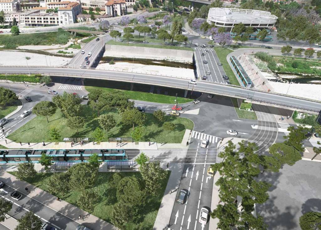
Another bird’s eye view of the proposed tramway at La Trinité, the River Paillon and Pont Anatole France with a tram turning to run alongside the river. [11]
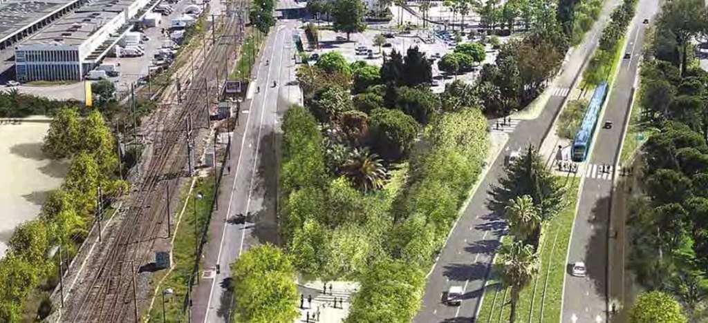
Les Chênes Verts tram stop in Drap and La Trinité. [11]
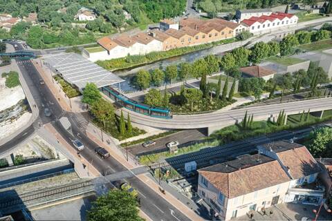
The approach to the Drap will bring trams across the River Paillon immediately adjacent to the terminus. [11]

Public Consultation took place between January and March 2022 and as a result some refinements were made to proposals. Currently (November 2023) the project includes for:

– 7.6 km of tramway

– 16 stations 

– 25 minutes between the two terminals

– 1 tram every 8 minutes

– 50,000 inhabitants and 28,000 jobs served

– 16,000 fewer cars every day in the Paillon valley

– 2000 tonnes of CO² avoided per year.

The calendar for the development and implementation of the project is:

2024: public inquiries (environmental, water law, public utility, land, etc.)

2026: Construction of the length through Pont-Michel to Pont Garigliano

2028: Construction of the remaining length to Drap. [11]


The public consultation resulted in a near unanimous approval of the project. 98% of the opinions expressed by the public were favourable. And 100% of elected representatives supported the scheme. [16]

The service station (left) at the Garigliano crossroads, in Nice, will disappear to allow the passage of the tram, © Richard Ray. [16]

This project is eagerly awaited by residents and we know how to recognize when a consultation is going well,” said the leader of the environmentalists, Juliette Chesnel-Le Roux. [16]

The Nice Côte d’Azur Metropolis has obtained European funding of 823,924 euros to finance all the studies carried out for the tram project linking the Ariane district to the city center of Nice and La Trinité. This funding comes from the European Regional Development Fund (ERDF) which aims to strengthen economic, social and territorial cohesion within the European Union as part of the Integrated Territorial Investment of the Nice Côte d’Azur Metropolis.” [17]

And further into the Future?Towards Monaco?

It is possible that Ligne 2 may be extended. Some consideration is being given to an extension to Ligne 2 of the tramway, beyond the current eastern terminus of the Lympia port, towards the principality of Monaco. “It would provide a second rail line between the metropolis of Nice Côte d’Azur and Monaco, and be an alternative to the TER PACA network.” [20]

References

  1. https://en.wikipedia.org/wiki/Nice_tramway, accessed on 26th October 2023.
  2. https://web.archive.org/web/20130515035144/http://www.lignesdazur.com/presentation/?rub_code=9&thm_id=7&gpl_id=, accessed on 26th October 3023.
  3. https://www.frenchrivieratraveller.com/Nice/Transport/Tramway.html, accessed on 26th October 2023.
  4. https://www.railway-technology.com/projects/nice-trams/?cf-view, accessed on 24th November 2023.
  5. https://projets-transports.nicecotedazur.org/ligne-1/hier-aujourdhui, accessed on 24th November 2023.
  6. https://projets-transports.nicecotedazur.org/actualites, accessed on 24th November 2023.
  7. https://projets-transports.nicecotedazur.org/ligne-4/enquete-publique-du-lundi-12-juin-au-vendredi-21-juillet-2023-inclus, accessed on 24th November 2023.
  8. https://projets-transports.nicecotedazur.org/wp-content/uploads/2023/09/Ligne-4-tramway-rapport-d-enquete.pdf, accessed on 24th November 2023.
  9. https://projets-transports.nicecotedazur.org/wp-content/uploads/2023/09/Ligne-4-tramway-CONCLUSIONS-DUP-MECDU.pdf, accessed on 24th November 2023.
  10. https://projets-transports.nicecotedazur.org/questions-reponses/#faq_27231, accessed on 25th November 2023.
  11. https://projets-transports.nicecotedazur.org/ligne-5/le-projet-de-la-ligne-5-de-tramway-nice-la-trinite-drap, accessed on 25tj November 2025.
  12. https://projets-transports.nicecotedazur.org/wp-content/uploads/2023/06/MNCA_TRAM-L4_BROCHURE_TT-SAVOIR_A4_BD.pdf, accessed on 25th November 2023.
  13. https://saintlaurentduvar.fr/blog/ligne-4-du-tramway-l-enquete-publique-est-lancee, accessed on 25th November 2023.
  14. https://twitter.com/Elodieching/status/1484215486867021824?t=JFKe_qZVQzGO-STX2SqQrQ&s=19, accessed on 25th November 2023.
  15. https://www.lemoniteur.fr/article/metropole-de-nice-la-t5-une-ligne-de-tram-vertueuse.2215172, accessed on  25th November 2023.
  16. https://www.nicematin.com/transports/approuve-a-lunanimite-trace-prefere-craintes-exprimees-bon-depart-pour-le-projet-de-tramway-entre-drap-et-nice-777378, accessed on 25th November 2023.
  17. https://www.investincotedazur.com/ligne5-tramway-nice, accessed on 25th November 2023.
  18. https://fr.m.wikipedia.org/wiki/Ligne_2_du_tramway_de_Nice, accessed on 25th November 2023.
  19. https://www.pss-archi.eu/forum/viewtopic.php?pid=835184, accessed on 25th November 2023.
  20. https://www.intelligenttransport.com/transport-news/18414/tram-design-revealed-for-the-east-west-line-of-the-nice-cote-dazur-metropole, accessed on 26th November 2023.
  21. https://www.railway-technology.com/projects/citadis-x05-light-rail-vehicles, accessed on 26th November 2023.
  22. https://commons.m.wikimedia.org/wiki/File:Nice_tramway_place_Garibaldi.jpg, accessed on 26th November 2023.
  23. https://en.m.wikipedia.org/wiki/File:Ligne_2_Tram_de_Nice_07-20.jpg, accessed on 26th November 2023.
  24. https://moovitapp.com/index/en/public_transit-line-L1-Nice-3260-854686-771043-0, accessed on 26th November 2023.
  25. https://www.batiactu.com/edito/ligne-2-tramway-nice-arrive-a-aeroport-54985.php, accessed on 26th November 2023.
  26. https://www.frenchrivieratraveller.com/Nice/Transport/Tramway.html, accessed on 26th November 2023.
  27. https://www.nice.fr/fr/transports-et-deplacements/la-ligne-3, accessed on 26th November 2023.
  28. https://fr.m.wikipedia.org/wiki/Ligne_3_du_tramway_de_Nice, accessed on 26th November 2023.