Many people will have been told that the sin of Sodom was homosexuality. Despite the fact that we use the word ‘sodomy’ to relate to homosexual sin, it is by no means certain that Sodom’s sin was homosexuality. It does not fit well with the Old Testament references to Sodom and Gomorrah. We also have to note that the idea of being ‘homosexual’ was not a concept in use until the 19th century AD when the word was first coined. However, that the sin of Sodom was ‘homosexuality’ is the traditional position, and it is the position taken by much of the worldwide Christian community.
But we are getting ahead of ourselves. Perhaps, first, I should set the scene. The Old Testament book of Genesis tells us that Abram’s nephew chose to live in the Jordan valley. Genesis 13 is the first time we hear of this:
“And Lot lifted up his eyes and saw that the Jordan Valley was well watered everywhere like the garden of the Lord, like the land of Egypt, in the direction of Zoar. (This was before the Lord destroyed Sodom and Gomorrah.) … Abram settled in the land of Canaan, while Lot settled among the cities of the valley and moved his tent as far as Sodom. Now the men of Sodom were wicked, great sinners against the Lord.” [Genesis 13:10-13 ESV]
Not many chapters later in Genesis we get a substantial story of a meeting between Abram and God and two angels (all three appearing as men), that story develops into a bargaining by Abram with God to save the cities of Sodom and Gommorah, with God eventually promising not to destroy the two cities provided 10 righteous people could be found in the cities. [Genesis 18: 1-33]
Later, the two angels visit Sodom in the guise of men, they meet Lot sitting at the gates of the city. He invites them into his home. He shows the two ‘men’ hospitality. While they are with him, the book of Genesis tells us, “before they lay down, the men of the city, the men of Sodom, both young and old, all the people to the last man, surrounded the house. And they called to Lot, “Where are the men who came to you tonight? Bring them out to us, that we may know them.” Lot went out to the men at the entrance, shut the door after him, and said, “I beg you, my brothers, do not act so wickedly. Behold, I have two daughters who have not known any man. Let me bring them out to you, and do to them as you please. Only do nothing to these men, for they have come under the shelter of my roof.” But they said, “Stand back!” And they said, “This fellow came to sojourn, and he has become the judge! Now we will deal worse with you than with them.” Then they pressed hard against the man Lot, and drew near to break the door down. But the men reached out their hands and brought Lot into the house with them and shut the door. And they struck with blindness the men who were at the entrance of the house, both small and great, so that they wore themselves out groping for the door. Then the men said to Lot, “Have you anyone else here? Sons-in-law, sons, daughters, or anyone you have in the city, bring them out of the place. For we are about to destroy this place, because the outcry against its people has become great before the Lord, and the Lord has sent us to destroy it.” So Lot went out and said to his sons-in-law, who were to marry his daughters, “Up! Get out of this place, for the Lord is about to destroy the city.” But he seemed to his sons-in-law to be jesting.” [Genesis 19: 4-14 ESV]
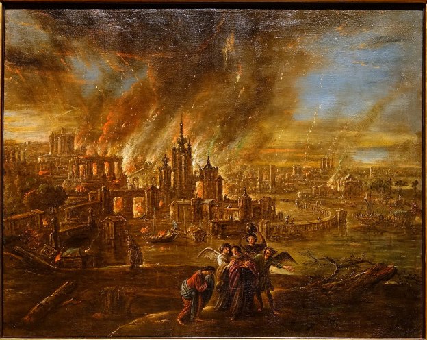
Genesis 19 goes on to tell of how Lot is removed from the city of Sodom by the two angels, Lot, his wife and his two daughters; and of how Sodom and Gomorrah are destroyed. The angels told Lot and his family to leave and to avoid looking back. But, in the story, Lot’s wife looks back and is turned into a pillar of salt.
There is no doubt that the Bible tells us that Sodom and Gommorah’s sins were very great. But what is it that led to the assumption that it was homosexuality that was the issue?
The key verse that is said to indicate that this is true is verse 5 of Genesis 19. “And they called to Lot, “Where are the men who came to you tonight? Bring them out to us, that we may know them.” [Genesis 19: 5]
There is a clear inference, in the word ‘know’, of sexual intercourse. But what is the motive and what is actually going on?
Lot does not interpret their request as a primarily homosexual request. He sees it as being something different. He offers his two daughters to the crowd, so that they might ‘know’ them instead. The desire of the crowd appears to be violent gang-rape. It is about power, control and abuse. The gender of those who were the objects of abuse is not important. But this is also, clearly, about the complete negation of the duty of hospitality.
There is nothing right about Lot offering his daughters to the crowd. It is heinous and wrong. It must raise questions for us today about Lot’s own righteousness. But it does say something very important about what was at stake. Abuse, dominance, control and rape. It has been accepted for sometime now that when a man rapes a woman, it is the exercise of dominance and power, enforcing his will on a woman, it is not primarily about sexual intercourse. The Rape Crisis Centre is clear about this. If there is no consent, “it’s not sex, it’s rape. No matter the circumstances.” [1] is also about hospitality. As Lot says, “Do nothing to these men, for they have come under the shelter of my roof.” [Genesis 19:8] We perhaps struggle to understand the gravity of this issue. Hospitality was a sacred trust.
Just as important is the theme of hospitality. As Lot says, “Do nothing to these men, for they have come under the shelter of my roof.” [Genesis 19:8] We perhaps struggle to understand the gravity of this issue. Hospitality was a sacred trust. This is emphasised, in the story, by Lot’s willingness to sacrifice his two daughters rather than give up his guests.
We know that, in Greek society, “hospitality, also called “guest-friendship,” was a social ritual expected of men in the Greek world. Under the rules of hospitality, men would be expected to host visitors, providing them with food, a bath, friendship gifts, the promise of safety for the night, and safe escorted travel to their next destination.” [2]
In Roman society, “Hospitium … [was] the … concept of hospitality as a divine right of the guest and a divine duty of the host. Similar or broadly equivalent customs were and are also known in other cultures, though not always by that name. Among the Greeks and Romans, hospitium was of a twofold character: private and public.” [3]
These values were shared throughout the ancient world and a failure to observe these values was a matter of grave dishonour. Great shame was brought on the household that failed to be hospitable. We, today, cannot fully enter into the gravity of that kind of failure.
From the story in Genesis, we have two areas to focus on as the awful sin of Sodom and Gommorah: violent gang-rape and negation of a sacred duty of hospitality. But what does the rest of the bible say about the sin of Sodom and Gommorah?
Sodom and Gommorah in the wider Old Testament
There are a number of references throughout the Old Testament to Sodom and Gommorah. Often these are graphic in their description of the punishment meted out on the two cities, see, for example: Deuteronomy 29:23. They are clear that Sodom and Gommorah had no shame, and flaunted their sinfulness before the world, see, for example: Isaiah 3:8-9. They are used as comparators for the evil deeds of Israel itself, see for example: Jeremiah 23:14, Amos 4:11. The two cities are also used as a warning to others that Israel believes are godless evildoers, see for example: Isaiah 13:19.
Amid these various references are some which describe Sodom’s sin.
“Isaiah, in condemnatory mode, compares the nation of Judah to Sodom and Gomorrah, saying that Judah needs to learn to do good, to seek justice, to rescue the oppressed, to defend the orphan, and to plead for the widow. … There is no mention of sexual sin.” [Isaiah 1: 9-17][4: p39]
“The same pattern holds later in Isaiah, where Judah is judged for being like Sodom. Why? Because the people are ‘grinding the faces of the poor’.” [Isaiah 3: 9-15)][4: p39]
Ezekiel says: “Behold, this was the guilt of your sister Sodom: she and her daughters had pride, excess of food, and prosperous ease, but did not aid the poor and needy. They were haughty and did an abomination before me. So I removed them, when I saw it.” [Ezekiel 16:49-50 ESV] Ezekiel first focusses on Sodom’s pride, excess of food and prosperous need which did not result in care for the poor and needy. He then mentions an abomination. This is a term that we need to consider and we will do so later in this article.
There is one Old Testament passage that does not directly mention Sodom and Gommorah, but which appears to closely mirror the story from Genesis 18 & 19. That passage is in the book of Judges:
“In those days, when there was no king in Israel, a certain Levite was sojourning in the remote parts of the hill country of Ephraim, who took to himself a concubine from Bethlehem in Judah. And his concubine was unfaithful to him, and she went away from him to her father’s house at Bethlehem in Judah, and was there some four months. Then her husband arose and went after her, to speak kindly to her and bring her back. He had with him his servant and a couple of donkeys. And she brought him into her father’s house. And when the girl’s father saw him, he came with joy to meet him. And his father-in-law, the girl’s father, made him stay, and he remained with him three days. So they ate and drank and spent the night there. And on the fourth day they arose early in the morning, and he prepared to go, but the girl’s father said to his son-in-law, “Strengthen your heart with a morsel of bread, and after that you may go.” So the two of them sat and ate and drank together. And the girl’s father said to the man, “Be pleased to spend the night, and let your heart be merry.” And when the man rose up to go, his father-in-law pressed him, till he spent the night there again. And on the fifth day he arose early in the morning to depart. And the girl’s father said “Strengthen your heart and wait until the day declines.” So they ate, both of them. And when the man and his concubine and his servant rose up to depart, his father-in-law, the girl’s father, said to him, “Behold, now the day has waned toward evening. Please, spend the night. Behold, the day draws to its close. Lodge here and let your heart be merry, and tomorrow you shall arise early in the morning for your journey, and go home.”
But the man would not spend the night. He rose up and departed and arrived opposite Jebus (that is, Jerusalem). He had with him a couple of saddled donkeys, and his concubine was with him. When they were near Jebus, the day was nearly over, and the servant said to his master, “Come now, let us turn aside to this city of the Jebusites and spend the night in it.” And his master said to him, “We will not turn aside into the city of foreigners, who do not belong to the people of Israel, but we will pass on to Gibeah.” And he said to his young man, “Come and let us draw near to one of these places and spend the night at Gibeah or at Ramah.” So they passed on and went their way. And the sun went down on them near Gibeah, which belongs to Benjamin, and they turned aside there, to go in and spend the night at Gibeah. And he went in and sat down in the open square of the city, for no one took them into his house to spend the night.
And behold, an old man was coming from his work in the field at evening. The man was from the hill country of Ephraim, and he was sojourning in Gibeah. The men of the place were Benjaminites. And he lifted up his eyes and saw the traveler in the open square of the city. And the old man said, “Where are you going? And where do you come from?” And he said to him, “We are passing from Bethlehem in Judah to the remote parts of the hill country of Ephraim, from which I come. I went to Bethlehem in Judah, and I am going to the house of the Lord, but no one has taken me into his house. We have straw and feed for our donkeys, with bread and wine for me and your female servant and the young man with your servants. There is no lack of anything.” And the old man said, “Peace be to you; I will care for all your wants. Only, do not spend the night in the square.” So he brought him into his house and gave the donkeys feed. And they washed their feet, and ate and drank.
As they were making their hearts merry, behold, the men of the city, worthless fellows, surrounded the house, beating on the door. And they said to the old man, the master of the house, “Bring out the man who came into your house, that we may know him.” And the man, the master of the house, went out to them and said to them, “No, my brothers, do not act so wickedly; since this man has come into my house, do not do this vile thing. Behold, here are my virgin daughter and his concubine. Let me bring them out now. Violate them and do with them what seems good to you, but against this man do not do this outrageous thing.” But the men would not listen to him. So the man seized his concubine and made her go out to them. And they knew her and abused her all night until the morning. And as the dawn began to break, they let her go. And as morning appeared, the woman came and fell down at the door of the man’s house where her master was, until it was light.
And her master rose up in the morning, and when he opened the doors of the house and went out to go on his way, behold, there was his concubine lying at the door of the house, with her hands on the threshold. He said to her, “Get up, let us be going.” But there was no answer. Then he put her on the donkey, and the man rose up and went away to his home. And when he entered his house, he took a knife, and taking hold of his concubine he divided her, limb by limb, into twelve pieces, and sent her throughout all the territory of Israel. And all who saw it said, “Such a thing has never happened or been seen from the day that the people of Israel came up out of the land of Egypt until this day; consider it, take counsel, and speak.”
[Judges 19: 1-30]
The story continues with a gathering of the people of Israel and with the punishment of Gibeah and Benjamin in Judges 20 & 21.
There are strong parallels in this story from Judges with the story from Genesis. A key verse is directly equivalent: “And they said to the old man, the master of the house, “Bring out the man who came into your house, that we may know him.”.” [Judges 19: 22] The story then develops with a very similar offer to the crowd before eventually the concubine is thrown out to the crowd who abuse her and leave her for dead.
This story provokes, in me, the same, if not more, revulsion as the Genesis story. But on this occasion the crowd go on to abuse the concubine in place of the man. There are no angels to prevent the abuse, this time. What we might call ‘homosexuality’ is clearly not the primary desire of the crowd. They wanted to dominate, to abuse, to destroy, to dishonour, to violently gang-rape the man, and the concubine was seen as an acceptable alternative recipient of their depraved actions. This is again a story of gang-rape and abuse. (There are parts of the Bible which I sincerely dislike.) And it also demonstrably clear, once again, that it is a story of flagrant disregard for the sacred duty of hospitality.
Sodom and Gommorah in the New Testament
There are four mentions of Sodom and Gommorah in the words of Jesus, two in Matthew and two in Luke:
Matthew 10:14-15 ESV: “And if anyone will not receive you or listen to your words, shake off the dust from your feet when you leave that house or town. Truly, I say to you, it will be more bearable on the day of judgment for the land of Sodom and Gommorah than for that town.”
Matthew 11:23-24 ESV: “And you, Capernaum, will you be exalted to heaven? You will be brought down to Hades. For if the mighty works done in you had been done in Sodom, it would have remained until this day. But I tell you that it will be more tolerable on the day of judgment for the land of Sodom than for you.”
Luke 10:10-13 ESV: “But whenever you enter a town and they do not receive you, go into its streets and say, ‘Even the dust of your town that clings to our feet we wipe off against you. Nevertheless know this, that the kingdom of God has come near.’ I tell you, it will be more bearable on that day for Sodom than for that town. “Woe to you, Chorazin! Woe to you, Bethsaida! For if the mighty works done in you had been done in Tyre and Sidon, they would have repented long ago, sitting in sackcloth and ashes.“
Luke 17:26-30 ESV: “Just as it was in the days of Noah, so will it be in the days of the Son of Man. They were eating and drinking and marrying and being given in marriage, until the day when Noah entered the ark, and the flood came and destroyed them all. Likewise, just as it was in the days of Lot—they were eating and drinking, buying and selling, planting and building, but on the day when Lot went out from Sodom, fire and sulphur rained from heaven and destroyed them all— so will it be on the day when the Son of Man is revealed.”
None of these passages relate to ‘homosexuality’. The first, in Matthew 10 relates to a violation of ‘hospitality’. The second in Matthew 11 relates to a failure by towns to recognise Jesus’ ministry. The third relates again to a violation of ‘hospitality’. In Luke 17, in the last of these references, Jesus’ rebukes those who do not recognise the coming of the Kingdom of God.
Paul does not use Sodom and Gommorah as examples in his argument in Romans 1 & 2. He does mention them later in Romans as part of his discussion about righteousness coming through faith and not through obedience to the law. [Romans 9: 22-33]
He also does not refer to them in his argument in 1 Corinthians 6 (which incidentally includes a reference to homosexuality in the ESV and the NIV (later edition). Most other translators, against the choice of the translators of the ESV and NIV, recognise the dubious and uncertain nature of the two Greek words which are translated in the ESV and NIV as ‘men who practice homosexuality‘.)
1 Timothy also does not include a reference to Sodom and Gommorah in the arguments made in chapter one, although in the ESV and the NIV, verse 10 suffers from the same failure to recognise the uncertain nature of the Greek words which are translated as ‘men who practice homosexuality‘. [1 Timothy 1:10]
2 Peter does mention the two cities and God’s rescue of Lot, in an argument about God’s ability to protect the godly from trials. [2 Peter 2: 6-9]
The final reference in our bibles to Sodom and Gommorah comes in Jude 1:7 and talks of their punishment for indulging in sexual immorality and pursuing ‘unnatural desire‘. [Jude 1:7]
To summarise what we have already established:
- Genesis sees the sin of Sodom and Gommorah as that of gang-rape, abuse of power and significantly, a violation of ‘hospitality’.
- The wider Old Testament seems to support this but includes pride, excess of food and prosperity which did not result in care for the poor and needy. In one place, in Ezekiel 16, in addition a failure to care for the poor and needy, there is mention of an abomination. As already promised, we will come back to that term later in this article.
- Jesus uses Sodom and Gommorah as examples of violation of ‘hospitality’ and what will happen to those who fail to recognise the coming of God’s kingdom. He also says that what happened to Sodom and Gommorah is nothing compared to what will happen to those who fail to accept the evidence of his miracles.
- Paul uses the two cities as part of his arguments about righteousness coming through faith in Romans. Although not specifically in Romans 1 or 2. He does, however, use words in 1 Corinthians 6 (and which also appear in 1 Timothy 1) which some modern translators have chosen to render as ‘men who practice homosexuality‘. We clearly need to look at these references in more detail, but must note that neither of these passages mention Sodom and Gommorah.
- Jude mentions ‘unnatural desire‘ and in doing so mentions Sodom and Gommorah. We clearly needed to consider this in more detail.
This means that apart from three possible references in our Bibles we have no grounds for considering the sin of Sodom to be ‘homosexuality’. But, let’s look at each of these references in turn: abomination; unnatural desire; and ‘men who practice homosexuality’.
An Abomination
The ESV translates the Hebrew word in Ezekiel 16:50 as ‘an abomination‘, the NIV translates this as ‘detestable things’, the King James, as ‘abomination’, the NRSV, as ‘abominable things’. There is a reasonable consistency in these translations.
Wikipedia offers the following …
“Abomination (from Latin abominare ‘to deprecate as an ill omen’) is an English term used to translate the Biblical Hebrew terms shiqquts שיקוץ and sheqets שקץ, which are derived from shâqats, or the terms תֹּועֵבָה, tōʻēḇā or to’e’va (noun) or ‘ta’ev (verb). An abomination in English is that which is exceptionally loathsome, hateful, sinful, wicked, or vile. The term shiqquts is translated abomination by almost all translations of the Bible. The similar words, sheqets, and shâqats, are almost exclusively used to refer to unclean animals. The common but slightly different Hebrew term, tōʻēḇā, is also translated as abomination in the Authorized King James Version, and sometimes in the New American Standard Bible. Many modern versions of the Bible (including the New International Version and New English Translation) translate it detestable; the New American Bible translates it loathsome. It is mainly used to denote idolatry; and in many other cases it refers to inherently evil things such as illicit sex, lying, murder, deceit, etc.; and for unclean foods.” [5]
Wikipedia is not the worst place to start looking for meanings of words. But it should definitely be treated with caution. We can confirm, elsewhere, that the word used in Ezekiel 16:50 is תוֹעֵבָ֖ה … ṯō-w-‘ê-ḇāh. [6] Transliteration of the Hebrew text can at times be a little confusing, as the same word can be rendered slightly differently, phonetically, in our own script. There is, however, no doubt that the word used in Ezekiel 16:50 is the same word as used in Leviticus 18:22 which says:
“You shall not lie with a male as one lies with a female; it is an abomination.” [Leviticus 18:22]
So, surely this is the conclusive link, there is a verse that confirms that the sin of Sodom with homosexuality. … But does it?
It am not an expert on the Hebrew text, but I am told that “the Hebrew word “toevah” (translated “abomination” and “detestable act”) is a cultic, not a moral, term. The English “abomination” means abhorrent, loathsome, unspeakably bad. Toevah means ritually unclean. Eating pork is toevah; having sex with a menstruating woman is toevah. You cannot come to worship after doing these things until you have been purified.” [7]
Greg Koukl quotes this as being a fair understanding of the word but insists that to use this in an argument to minimise the ‘abomination’ involved, is, in his view, unacceptable. He takes a traditional position on this matter. In the context of Leviticus 18 there is a series of different condemnatory statements about sexual sin and, in that context, Koukl dismisses any distinction between ‘cultic’ and ‘moral’ meanings of the word. And, in that context, his arguments have some weight. When we look at that passage, we will need to listen carefully to what he is saying.
However, here, we are trying to ascertain the meaning of the Hebrew word in a different context, that of Ezekiel 16, not Leviticus 18 or 20.
If, as Koukl says, the word usually has a ‘cultic’ rather than ‘moral’ meaning. How is it used in other parts of the Old Testament than Leviticus 18?
Patrick Beaulier notes the usage of tōʻēḇā in Leviticus and then shares details of its usage elsewhere in what we call the Old Testament. He highlights the following: [8]
- Every shepherd was “an abomination” unto the Egyptians (Genesis 46:34).
- Pharaoh was so moved by the fourth plague, that while he refused the demand of Moses, he offered a compromise, granting to the Israelites permission to hold their festival and offer their sacrifices in Egypt. This permission could not be accepted, because Moses said they would have to sacrifice “the abomination of the Egyptians” (Exodus 8:26); i.e., the cow or ox, which all the Egyptians held as sacred and so regarded as sacrilegious to kill.
- Proverbs 6:16-19 lists seven things which are also abominations: “haughty eyes, a lying tongue, hands that shed innocent blood, a heart that devises wicked schemes, feet that are swift in running to mischief, a false witness who utters lies, and one who spreads strife among brothers.”
- Tōʻēḇā is also used in Jewish scriptures to refer to: idolatry or idols (Deuteronomy 7:25, Deuteronomy 13:14, Isaiah 44:19); illicit sex (e.g. prostitution, adultery, incest) (Ezekiel 16:22,58, Ezekiel 22:11, Ezekiel 33:26); illicit marriage (Deuteronomy 24:2-4); … temple prostitution (1Kings 14:24); child sacrifice to Molech (Jeremiah 32:35); cross-dressing – likely for the sake of confusing a person for illicit reasons (Deuteronomy 22:5); cheating in the market by using rigged weights (Deuteronomy 25:13-19, Proverbs 11:1); dishonesty (Proverbs 12:22); dietary violations (Deuteronomy 14:3); stealing, murder, and adultery, breaking covenants (Jeremiah 7:9,10); usury, violent robbery, murder, oppressing the poor and needy, etc. (Ezekiel 18:10-13).
Given this range of different things that are called tōʻēḇā, from relatively minor things to more serious matters; and things which are clearly culturally related to things which have a more lasting relevance, it is difficult to be sure that the use of the word in Leviticus necessarily is parallel to that in our passage from Ezekiel. It is a presumption to assume that the usage of the word is exactly the same.
We need to leave discussion of the Leviticus passages for another time, but this does leave us with a significant level of confidence that the word tōʻēḇā in Ezekiel is most likely to be best translated as ‘taboo’ or by a very similar word.
Of further interest is what Beaulier notes in the Talmud, specifically Sanhedrin 109b: [9]
“When there was anyone who had a row of bricks, each and every one of the people of Sodom would come and take one brick and say to him: I am taking only one, and you are certainly not particular about so inconsequential an item, and they would do this until none remained. And when there was anyone who would cast garlic or onions to dry, each and every one of the people of Sodom would come and take one and say to him: I took only one garlic or onion, and they would do this until none remained.” [9]
“There were four judges in Sodom and they were named for their actions: Shakrai, meaning liar, and Shakrurai, habitual liar, Zayfai, forger, and Matzlei Dina, perverter of justice.” [9]
“When a poor person would happen to come to Sodom, each and every person would give him a dinar, and the name of the giver was written on each dinar. And they would not give or sell him bread, so that he could not spend the money and would die of hunger. When he would die, each and every person would come and take his dinar.” [9]
“There was a young woman who would take bread out to the poor people in a pitcher so the people of Sodom would not see it. The matter was revealed, and they smeared her with honey and positioned her on the wall of the city, and the hornets came and consumed her. And that is the meaning of that which is written: “And the Lord said: Because the cry of Sodom and Gomorrah is great [rabba]” (Genesis 18:20). And Rav Yehuda says that Rav says: Rabba is an allusion to the matter of the young woman [riva] who was killed for her act of kindness. It is due to that sin that the fate of the people of Sodom was sealed.” [9]
These quotations are typical of the material in that part of the Talmud, there is no mention of sexual sins of any kind! At the end of that section, in the last quotation above, there is commentary from scholars. They affirm that it was the matters covered immediately above that were the sin(s) that brought condemnation on Sodom.
This evidence, together with the uncertainty over the use of tōʻēḇā and the matters discussed earlier in this article means that it is really difficult, with integrity, to assume that the sin of Sodom was ‘homosexuality’.
It is also difficult to see that the word tōʻēḇā is rightly to be translated as ‘an abomination’ on every occasion. The term tōʻēḇā may often have had a different meaning: “something permitted to one group, and forbidden to another. Though there is (probably) no etymological relationship, toevah means taboo.” [10] I don’t think I could express quite the same level of certainty over the meaning of tōʻēḇā, as in that quotation, but even so, its use in many situations is probably closer to ‘taboo’ than ‘abomination’.
Unnatural Desire
What does Jude mean by ‘unnatural desire‘? [Jude 1:7, ESV]
Let’s take the expression in context first. Jude 1: 6-7 says:
“And the angels who did not stay within their own position of authority, but left their proper dwelling, he has kept in eternal chains under gloomy darkness until the judgment of the great day—just as Sodom and Gomorrah and the surrounding cities, which likewise indulged in sexual immorality and pursued unnatural desire (sarkos heteras), serve as an example by undergoing a punishment of eternal fire.” [Jude 1:6-7]
There is a case to be made that Jude’s comment about sarkos heteras (“other flesh”) is a reference to sex with angels. Verse 6 is probably a reference back to Genesis 6: 1-4 which in Jewish thought has angels indulging in sex with humans. So, in context, in Jude “it is not far fetched to think that the “other flesh” in verse 7 is a reference to the men of Sodom trying to have sex with Lot’s angelic visitors. If this interpretation is correct, it makes it less likely (though not … impossible) to see the sin of Sodom as being … the sin of homosexual practice.” [11]
However, this is not accepted by those who hold the traditional position on human sexuality.
There is definitely some warrant for thinking that Jude is making reference to Sodom and Gomorrah’s ongoing and persistent sin, whatever that sin was, rather just one occasion of Tring to have sex with angels.
But, Jude’s understanding of what happened in Sodom is at variance with the significant majority of Old Testament thought which, as we have seen, was primarily concerned with, either a negation of the sacred duty of ‘hospitality’, or about an ongoing failure to care for the poor and needy.
Jude does seem to be referring to Sodom’s ongoing sin, not just one sin on one occasion. In the context of his letter, this is related to angels who had perverted desires for human women. (Genesis 6: 1-4) The evidence of the Genesis story is that the men of Sodom intended violent gang-rape. So, whatever Jude means by ‘sarkos heteras‘. We have to subject Jude’s interpretation to the wider position of scripture which is that Sodom’s sexual sin was violent gang-rape. In the case in the Genesis story this happened to be focussed two men (who unknown to the men of Sodom were actually angels), but as that story played out could easily have been the violent gang-rape of two women. Their behaviour was probably typical of their actions on other occasions as they would readily set aside the sacred duty of hospitality for their own gratification.
We leave this passage in Jude with a sense of confusion about what is meant by Jude. It is not strong enough evidence to lead us to assume that the ultimate sin of Sodom was ‘homosexuality’. Neither is it reliable ground on which to make a firm case that Sodom’s sin was not ‘homosexuality’.
Men Who Practice Homosexuality
This phrase is used in two translations of the Bible, the ESV and the 2011 revision of the NIV. This ‘catch-all’ phrase in these two translations is not warranted by the individual greek words used in these two contexts.
In our discussion of Sodom’ sin we could ignore the question of these two words. Neither reference (1 Corinthuans 6 or 1 Timothy 1) includes a direct reference to Sodom and Gomorrah. However, the way the two Greek words are treated is a case of over simplification by the translators. In an endeavour to simplify a reading of the text, they have allowed their assumptions to narrow down meaning and perhaps even obfuscate what is true. The truth is that scholars either do not know, or cannot agree on the meaning of two Greek words, The two words are arsenokoitai (ἀρσενοκοίτης) and malakoi (μαλακοὶ). Their exact meanings are lost in the past and scholars have been debating the best translation of the words for some length of time.
The assumption that the translators of the ESV and the NIV make is that together they are a kind of ‘catch-all’ for all homosexual acts. This is just one opinion.
Look at how leading English translations treat these two words in 1 Corinthians 6:9: [12]
“men who practice homosexuality” (ESV; a marginal note reads, “The two Greek terms translated by this phrase refer to the passive and active partners in consensual homosexual acts”)
“men who have sex with men” (NIV [2011]; a marginal note reads, “The words men who have sex with men translate two Greek words that refer to the passive and active participants in homosexual acts”)
“male prostitutes … homosexual offenders” (NIV [1984]
“effeminate … homosexuals” (NASB 1995; a marginal note to the first word reads, “i.e. effeminate by perversion”
“effeminate … sodomites” (NKJV)
“effeminate … abusers of themselves with mankind” (AV)
“These translations appear to agree that the individuals in view are men who are engaged in some kind of sexual activity of which Paul disapproves. But the translations’ differences outshine their agreement. Should the terms be understood together or separately? Does the term malakos denote male homosexual activity (generally), the passive participant in a homosexual act, a man who engages in paid sexual activity with other men, or an effeminate man? Does the term arsenokoites denote male homosexual activity (generally) or the active participant in a homosexual act (specifically)?” [12]
Reviewing the evidence in commentaries and academic literature only widens the uncertainty over the meaning of these words. A survey of the commentaries and academic literature would yield further possibilities.
I have taken the short notes above from a conservative evangelical website [12] to illustrate that this breadth of meaning has to be embraced before the argument on that website concludes that, when taken together, the two words are a kind of ‘catch-all’ phrase which embraces all homosexuality, both inclination and action. So, many who hold the traditional position on ‘homosexuality’ argue that the particular texts which use these words, 1 Corinthians 6 and 1 Timothy 1, say that “homosexuals” will not inherit the kingdom of God. Hence, the church cannot affirm same-sex relationships without abandoning the gospel.
We have, however, to be very careful in dealing with these two words and look as closely as we can at their use in antiquity within the cultures of Paul’s day, and we must particularly endeavour not to read back into them the cultural categories of our own times. This is a trap which we can all fall into so easily.
The term malakoi literally meant “soft,” in the Greco-Roman culture of Paul’s day. It was often used to refer to, a lack of self-control, weakness, cowardice, and laziness. These were seen as negative characteristics and were often attributed to women in the societies of Paul’s day.
“The term was also long translated as ‘effeminate.’ Although most uses of the term in ancient literature were not related to sexual behaviour, men who took the passive role in same-sex relations were sometimes called ‘malakoi’, which is why many non-affirming Christians argue that it represents a condemnation of same-sex relationships. But even in sexual contexts, ‘malakos’ was most frequently used to describe men who were seen as lacking self-control in their love for women. It’s only in the past century that many Bible translators have connected the word specifically to same-sex relationships. More common English translations in past centuries were terms such as ‘weaklings’, ‘wantons’, and ‘debauchers‘.” [13]
Even so, doesn’t Paul’s practice of using malakoi and arsenokoti in tandem make it likely that he uses it in a way that refers to what we call ‘homosexual behaviour’?
The term arsenokoites “comes from two Greek words: arsen, meaning ‘male’, and koites, meaning ‘bed’. Those words appear together in the Greek translation of Leviticus 20:13, leading some to speculate that Paul coined the term arsenokoites in order to condemn same-sex behaviour.” [13] Whether this is a speculation rather than a warranted assumption is a matter of dispute, as traditionalists argue that it is the most likely meaning of the word as Paul used it.
Speaking from a liberal perspective, Carolyn V. Bratnober argues in ‘Legacies of Homosexuality in New Testament Studies: Arsenokoitai and malakoi, fornicators and sodomites, in the history of sexuality and scripture‘, that “the tragedy of conservative homophobia in the 1980s was this: that antihomosexual usage of biblical texts was enflamed by HIV/AIDS discourse—while, at the same time, the effects of the HIV/AIDS epidemic on communities in poverty and communities of colour were unreported for so long that the epidemic devastated these communities to a greater extent than it did gay communities. Progressive biblical scholars, as well as Christian Religious Right leaders, fed this focus on homosexuality in their studies of New Testament texts. They focused so much on homosexuality that they missed the big picture: anti-imperial, anti-exploitation theology. President Reagan’s condemnations of “welfare queens” and “moral failures,” bolstered by his supporters on the Religious Right, co-opted a version of Pauline ethics that supported empire rather than opposed it. Failure to acknowledge this deeply problematic history of Biblical literature is harmful for the contemporary LGBTQ community and for combatting the legacies of racism in the United States. There is a deep and urgent need for Biblical scholars and historians to heed the words of Emilie Townes and others calling for efforts toward a counterhegemonic history that overturns pervasive racist myths and invisibilized narratives that continue to marginalize oppressed groups based on perceived collective characteristics. Biblical scholars and those who utilize scriptural resources in their work must address the historic use of Pauline epistles in homophobic discourse. They must acknowledge that terms such as arsenokoitai and malakoi referred to those who were vulnerable to sexual and economic exploitation through the social institutions of slavery and forced sex in the Roman Empire.” [14: p51-52]
She is prepared to state categorically that the translation of arsenokoitai and malakoi to mean “homosexuals” or “sodomites” in the NRSV is false. “The idea of the ‘sin of Sodom’ can be traced to Biblical texts [although I question the link to ‘homosexual actions], but not ‘sodomy or ‘sodomites’- these terms were developed in the medieval period.” [14: p46] And she mentions the work of Scroggs, who argued that malakoi and arsenokoitai referred to counterparts in sexual encounters where prostitution and economic exploitation were involved—that malakoi would have had the meaning of a specific role, something similar to an “effeminate call-boy” or passive recipient in penetrative sex, and that arsenokoitai would have meant the active partner “who keeps the malakos as a mistress or hires him on occasion.”[14: p18][15: p108]
Scroggs mentions that the two words appear side by side in 1 Timothy 1 along with a third term andropdistai “which was used in several other ancient sources to describe one who is a kidnapper or, literally, a slave-dealer.” [15: p118-120] Scroggs interprets the author of 1 Timothy’s inclusion of andropodistai in his list of vices as a reference to specific forms of the sex economy “which consisted of the enslaving of boys as youths for sexual purposes.” [15: p121] so, if it was this institution of sexual slavery that was being condemned in 1 Timothy and even in 1 Corinthians, then it is slavery and rape
which must be the subject of all scholarship on arsenokoitai and malakoi in the
New Testament—not ‘homosexuality’ as such. [14: p18]
Bratnober spends some time delving into the appropriate meaning of these two words, but ultimately concludes that much energy has been wasted on this work which would have been better spent on wider issues such as “those who were vulnerable to sexual and economic exploitation through the social institutions of slavery and forced sex in the Roman Empire. [14: p52]
Just as we looked at early Jewish interpretations of the ‘sin of Sodom’, we do well, in the context of this article to note that some modern Jewish scholars talk of the ‘sin of Sodom’ as prohibited, because “the Canaanites used homosexual acts as part of their pagan rituals. Therefore the Israelites were prohibited from doing this, not because it was an act between two men but because it was symbolic of pagan ritual. In today’s world this prohibition now has no meaning (and homosexual sex is permitted).” [Rabbi Michele Brand Medwin, as quoted by Patrick Beaulier] [8]
So, what is the substance of my argument about the words arsenokoitai (ἀρσενοκοίτης) and malakoi (μαλακοὶ). It is simply this, that there remains sufficient disagreement about the meaning of these words among scholars, some of whom take a conservative position, others who are more liberal. We are actually unable to be clear of their meaning and tend to take the meaning(s) that most suit our own arguments. The translators of the revised version of the NIV [2011] and of the ESV abandon the middle ground and assert both in the text and in the margin that these two terms are effectively used together in a ‘catch-all’ way to relate to all forms of homosexuality. This is very far from certain. The NIV and ESV translators should have accepted the ongoing struggle with the translation of these two difficult words (perhaps using the words which appeared in the original 1984 version of the NIV (male prostitutes … homosexual offenders) and should have placed commentary in the margins which commented on their particular stance in the debate.
Conclusions
Where does this leave us?
In this article we have established that:
- Genesis sees the sin of Sodom and Gomorrah as that of gang-rape, abuse of power and very significantly, a violation of ‘hospitality’.
- The wider Old Testament seems to support this but includes pride, excess of food and prosperity which did not result in care for the poor and needy. In one place, in Ezekiel 16, in addition a failure to care for the poor and needy, there is mention of an abomination. We sought to address the meaning of the Hebrew word in the context of Ezekiel 16 and concluded that the original Hebrew word is best seen in that context to mean something like ‘taboo’ rather than ‘abomination’.
- We noted Jesus’ use of Sodom and Gommorah as examples of violation of ‘hospitality’ and what will happen to those who fail to recognise the coming of God’s kingdom. He also says that what happened to Sodom and Gommorah is nothing compared to what will happen to those who fail to accept the evidence of his miracles.
- Jude’s use of words which have been translated in the ESV as ‘unnatural desire’ – sarkos heteras (other flesh), is confusing. We left that passage in Jude with a sense of confusion about what is meant by Jude. It is not strong enough evidence to lead us to assume that the ultimate sin of Sodom was ‘homosexuality’. Neither is it reliable ground on which to make a firm case that Sodom’s sin was not ‘homosexuality’.
- And finally, Paul uses the two cities, Sodom and Gommorah, as part of his arguments about righteousness coming to God through faith in Romans. Although he does not use them specifically in Romans 1 or 2. He does, however, use words in 1 Corinthians 6 (and which also appear in 1 Timothy 1) which some modern translators have chosen to render as ‘men who practice homosexuality’. We clearly needed to look at these references in more detail, but we also had to note that neither of these passages directly mention Sodom and Gomorrah. We discovered that the evidence for that translation of the two words taken together is dubious.
- So we discussed possible options for the translation of malakoi and arsenokoitai, our conclusion was the the meanings are confusing and that commentators view the words in different ways. My conclusion was that translators should accept that the meanings of the two words are uncertain and that translations of the Bible should continue to recognise this.
The overall conclusion of this article is that the sin of Sodom cannot simply be seen as ‘homosexuality’ but rather as a range of sins taken together: violent gang-rape, egregious abandonment of the sacred duty of hospitality, pride, and a corrupt system which failed the poor and needy.
References
- https://rapecrisis.org.uk/get-informed/types-of-sexual-violence/what-is-rape, accessed on 16th February 2023.
- https://www.sparknotes.com/lit/odyssey/context/historical/hospitality-in-ancient-greece, accessed on 16th February 2023.
- https://en.wikipedia.org/wiki/Hospitium, accessed on 16th February 2023, cf. Hugh Chisholm ed.; Hospitium; in Encyclopædia Britannica. Vol. 13 (11th ed.), Cambridge University Press, 1911, p801.
- Jonathan Tallon; Affirmative: Why You Can Say Yes to the Bible and Yes to People Who Are LGBTQI+; Richardson Jones Press, 2022.
- https://en.m.wikipedia.org/wiki/Abomination_(Bible), accessed on 16th February 2023.
- https://biblehub.com/text/ezekiel/16-50.htm, accessed on 16th February 2023.
- Greg Koukl; Leviticus and Homosexuality; https://www.str.org/w/leviticus-and-homosexuality, accessed on 16th February 2023.
- https://www.sefaria.org/sheets/196548?lang=bi, accessed on 17th February 2023.
- The William Davidson Talmud (Koren – Steinsaltz), Sanhedrin 109b.
- https://wp.me/ppy6l-1C, accessed on 17th February 2023.
- https://www.thegospelcoalition.org/blogs/kevin-deyoung/what-does-jude-7-mean-by-other-flesh, accessed on 17th February 2023.
- https://gospelreformation.net/pauls-understanding-of-sexuality/?print=print, accessed on 18th February 2023.
- https://reformationproject.org/case/1-corinthians-and-1-timothy, accessed on 18th Fenruary 2023.
- Carolyn V. Bratnober; Legacies of Homosexuality in New Testament Studies: Arsenokoitai and malakoi, fornicators and sodomites, in the history of sexuality and scripture; Union Theological Seminary, New York, 2017.
- Robin Scroggs; The New Testament on Homosexuality: Contextual Background for Contemporary Debate; Fortress Press, Philadelphia, 1983.


