Tag Archives: travel

The Lough Swilly Railway continued. … Letterkenny to Derry – Part 2

This is the second post in a series about the L&LSR line from Letterkenny to Derry, the first can be found on this link:

The Lough Swilly Railway continued. … Letterkenny to Derry – Part 1

The last article left us at Newtowncunningham Railway Station. We continue from that location in this article.

Newtoncunningham to Tooban Junction Station

Newtowncunningham Railway Station as shown on the OSi 25″ survey. [3]
Newtowncunningham Railway Station as shown on railmaponline.com’s satellite imagery. Comparison with the map extract above shows that the bridge at the northern end of the station site has been removed and the road realigned, and the Goods Shed has been removed. Not seen easily on this satellite image is the Water Tower which remains in place. [2]
A plan of Newtowncunningham Railway Station provided by Dave Bell and Steve Flanders in their book: The Londonderry and Lough Swilly Railway: A Visitor’s Guide, and used by kind permission of Steve Flanders and the Donegal Railway Heritage Museum. [4: p39]
A series of three photographs taken at Newtowncunningham Railway Station provided by Dave Bell and Steve Flanders in their book: The Londonderry and Lough Swilly Railway: A Visitor’s Guide, and used by kind permission of Steve Flanders and the Donegal Railway Heritage Museum. The first shows the Station in 1953 and looks towards Derry, © H.C. Casserley. The second shows Locomotive No. 15 shunting the yard, © R.M. Casserley. The third, looks towards Derry and shows the water tower and signal box, H.C. Casserley. [4: p39]
Newtowncunningham Railway Station in 1937, looking towards Letterkenny, © H.C. Casserley, provided by Dave Bell and Steve Flanders in their book: The Londonderry and Lough Swilly Railway: A Visitor’s Guide, and used by kind permission of Steve Flanders and the Donegal Railway Heritage Museum. [4: p38]
The Station Approach, now in private hands, at Newtowncunningham Railway Station in the 1980s, provided by Dave Bell and Steve Flanders in their book: The Londonderry and Lough Swilly Railway: A Visitor’s Guide, and used by kind permission of Steve Flanders and the Donegal Railway Heritage Museum. [4: p38]
This image was shared on the Londonderry & Lough Swilly Railway Facebook Group by Willie Rodgers on 19th November 2021. [5]
Newtoncunnigham Railway Station House as seen from the highway. The building is now in private hands. [My photograph, 9th May 2024]
The road outside Moyle National School in the 21st century. Much of the embankment in the immediate vicinity of the road has been removed, the old bridge has gone and the road has been realigned. [Google Streetview, July 2021]

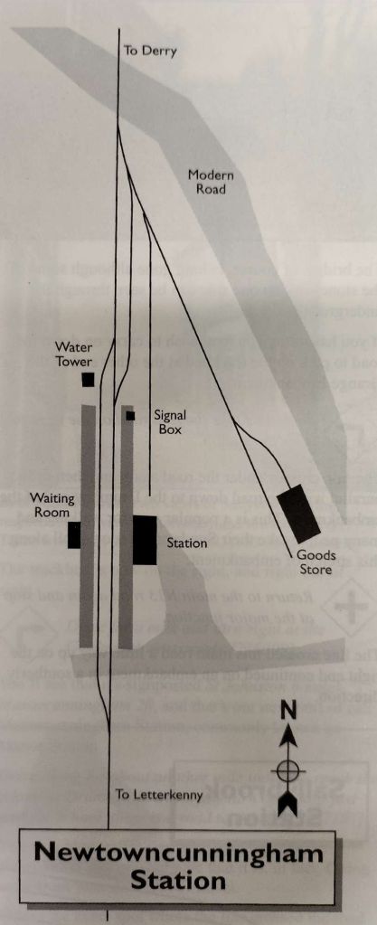
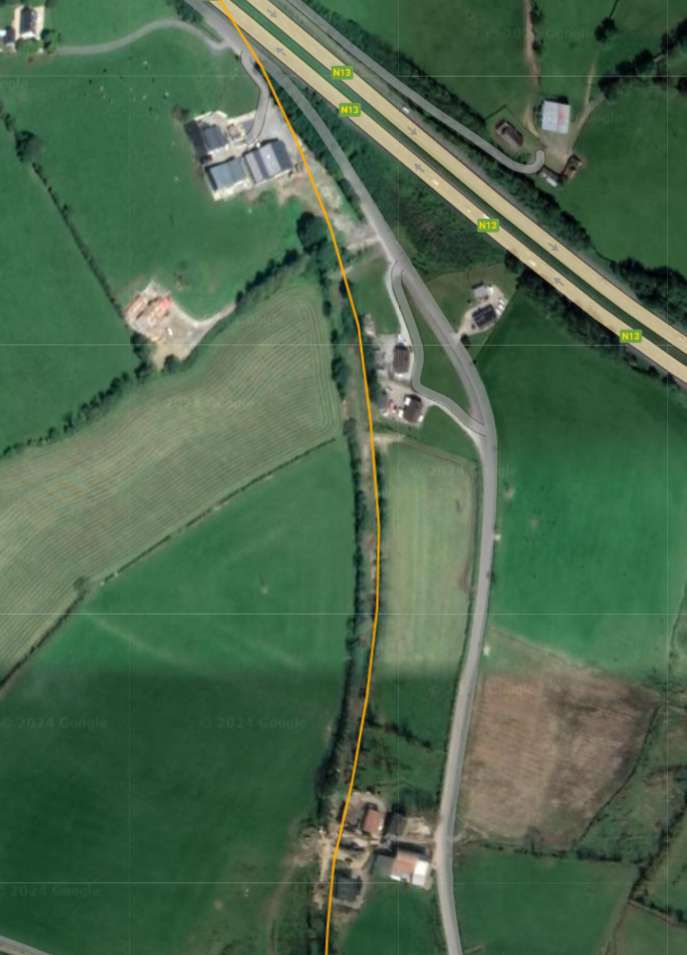
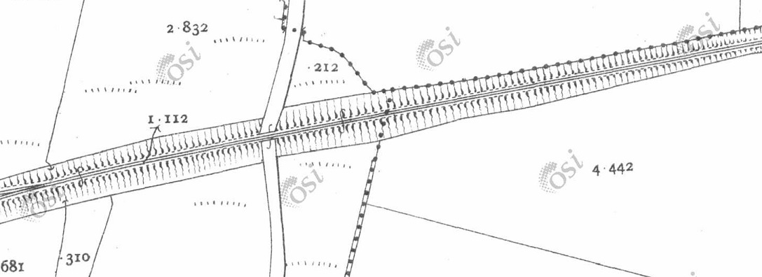
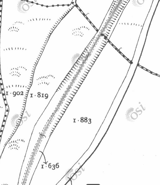
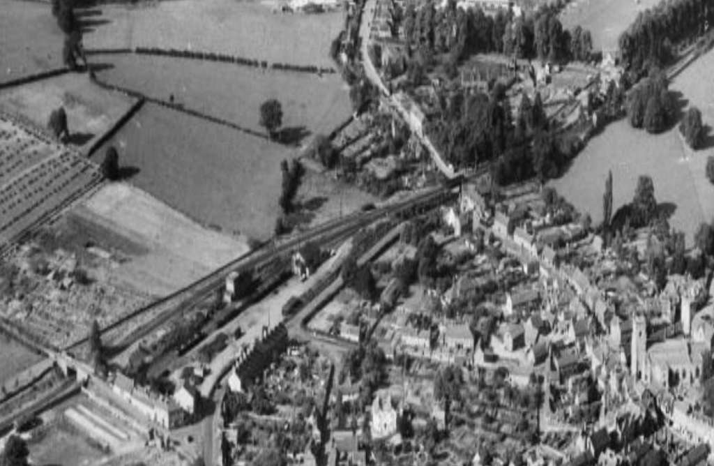
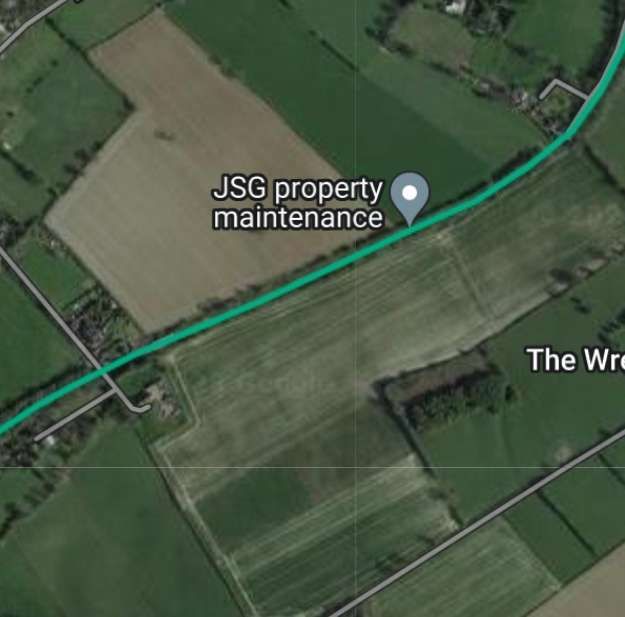
This next series of five extracts from the 25″ OSI survey show the Lough Swilly Railway heading North away from Newtowncunningham Railway Station.

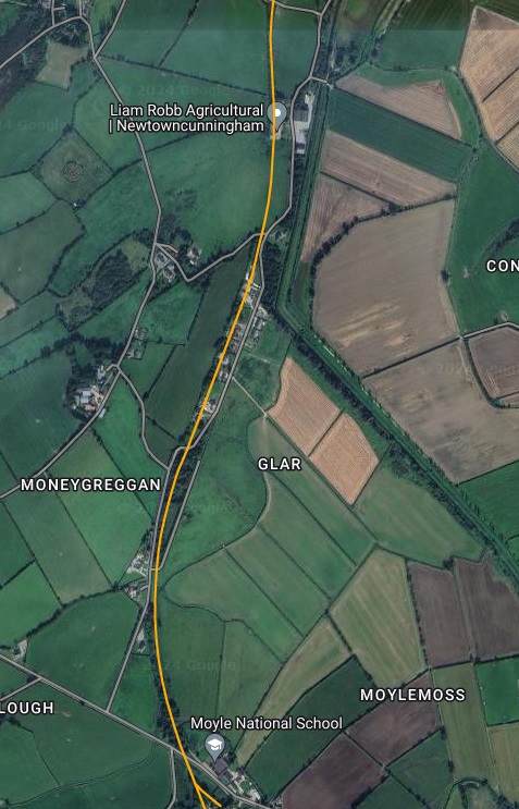
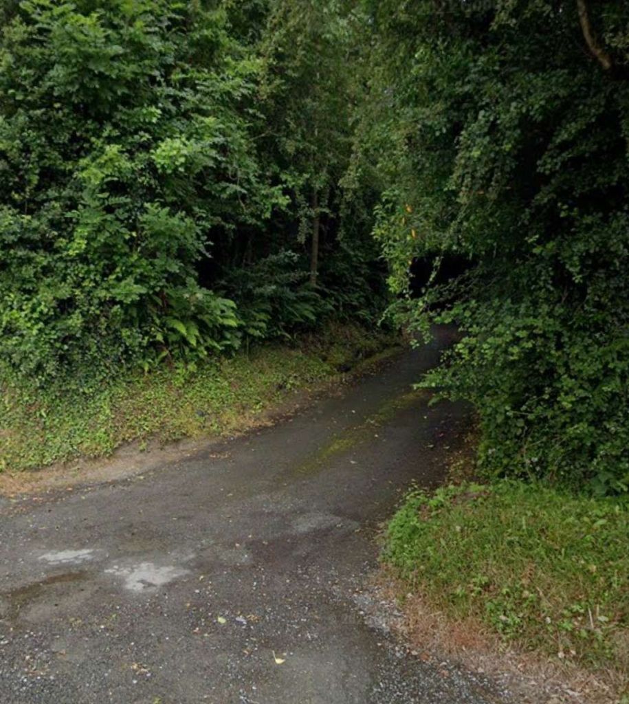
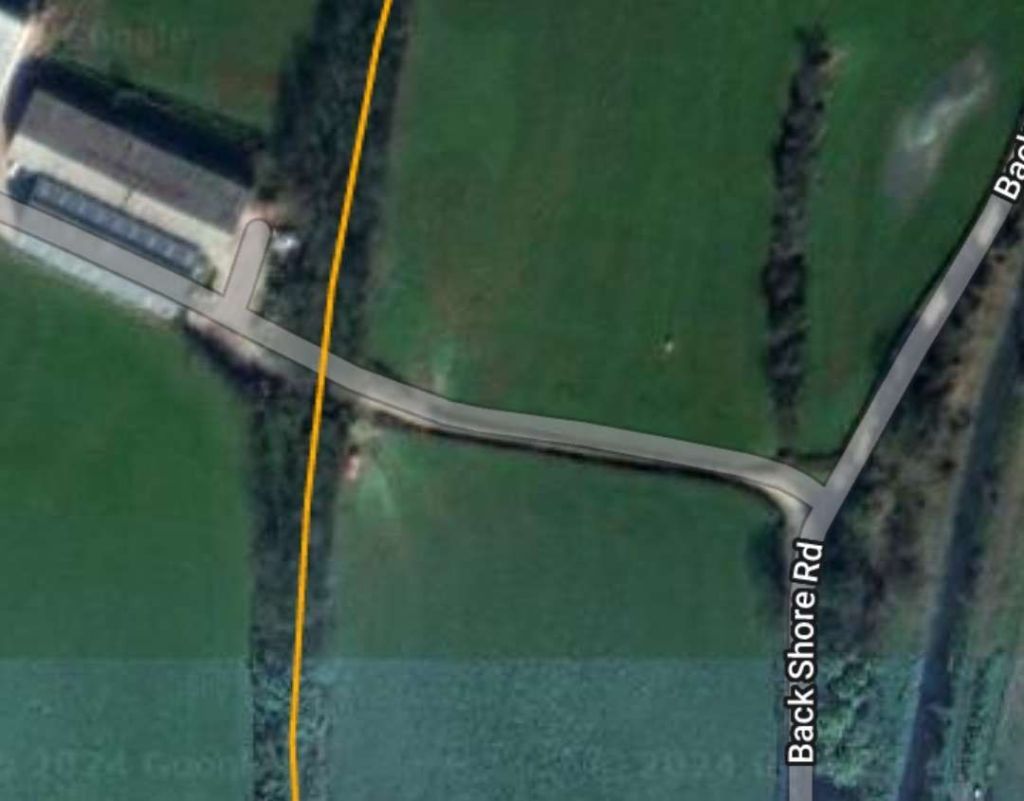
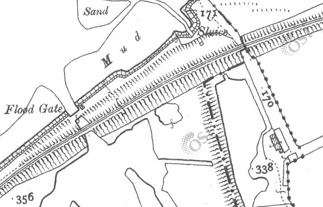
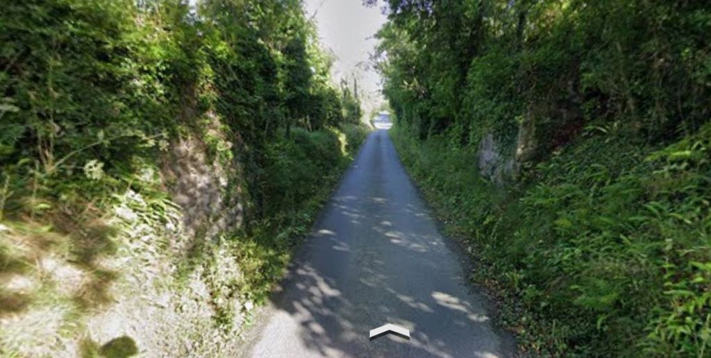
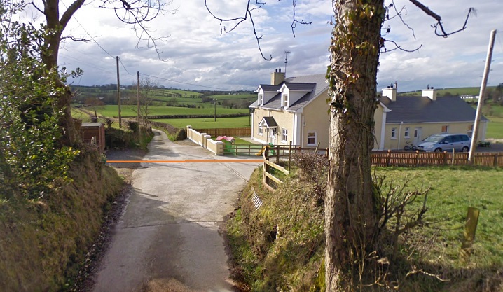
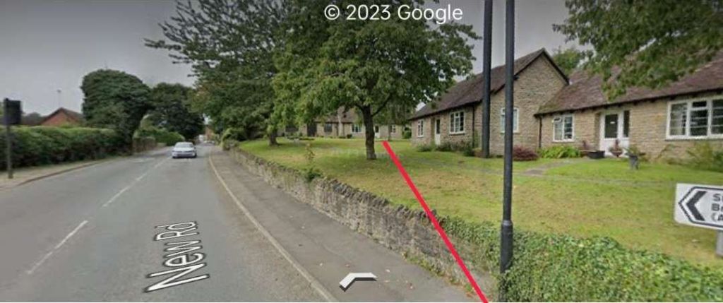
The series of five map extracts above show the Lough Swilly Railway to the North of Newtoncunningham and parallel to Back Shore  Road. [3]
This extract from railmaponline.com’s satellite imagery shows the railway heading North from Newtowncunningham Station, alongside Back Shore Road, and covers the same length of the line as shown in the five map extracts above. [2]
A track can be seen on the satellite image above crossing the line of the old railway as it curved round toward Moneygreggan. This photograph shows that lane. The photograph is taken from Back Shore Road running parallel to the line of the railway at this point. The track at this point was probably provided after the closure of the railway. It gives access to what was the old line of the road prior to the construction of the railway. With the construction of the railway the road was diverted to cross the railway further to the North. [Google Streetview, July 2021]
This enlarged extract from the OSi 25″ survey shows the changes made at the location of the photograph immediately above. [3]
This extract from the railmaponline.com satellite imagery shows the same location as the map extract immediately above. [2]

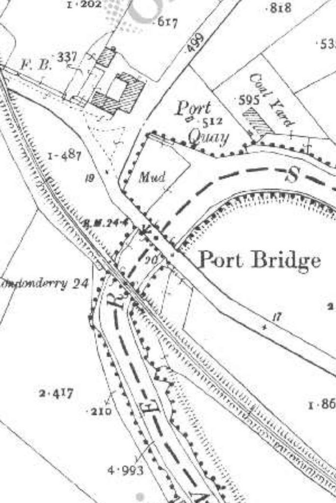
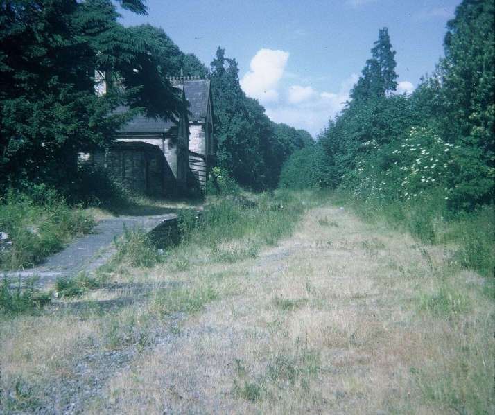
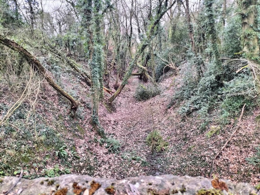
The next three images show the bridge in Moneygreggan which carried Back Shore Road over the line just to the North of the location above.

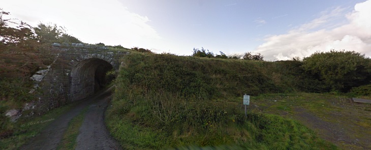
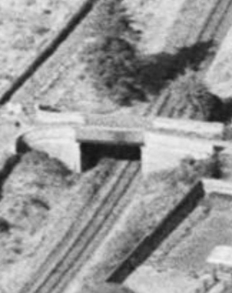
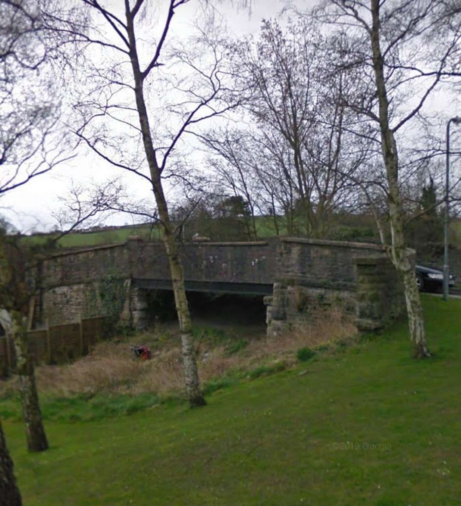
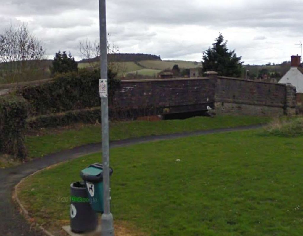
The road bridge constructed to carry Back Shore Road over the Lough Swilly Railway north of Newtoncunningham. [My photograph, 9th May 2024]
The view South across the bridge parapet in the direction of  Newtown Cunningham Station. [My photograph, 9th May 2024]
The view North across the parapet of the same bridge. [My photograph, 9th May 2024]
The next location worth noting along the line is a bridge over another minor road which headed West from Back Shore Road [3]
The same location, this time on the satellite imagery from railmaponline.com. [2]
The lane and the embankment are shrouded by trees. The line crossed the lane very close to its junction with Back Shore Road. [Google Streetview, July 2021]
The next crossing of the line was for what was once a through route of sorts but which now is really no more than a farm access track. On the OSi 26″ survey this appears to have crossed the old railway by means of an over bridge. [3]
Railmaponline.com’s satellite imagery shows the rail route in the 21st century shrouded in trees. [2]
This image looks West along the access road in 2011. Hidden in the trees over the line of the Lough Swilly Railway there are some masonry remains which might be parapet walls for a bridge. Either side of the track the undergrowth and tree cover is dense.[Google Streetview, August 2011]

A series of three further extracts from the 25″ OSi survey show the next length of the Lough Swilly Railway as it turned to the East.

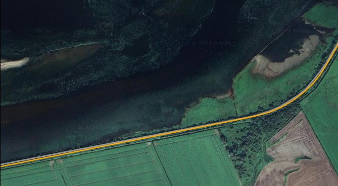
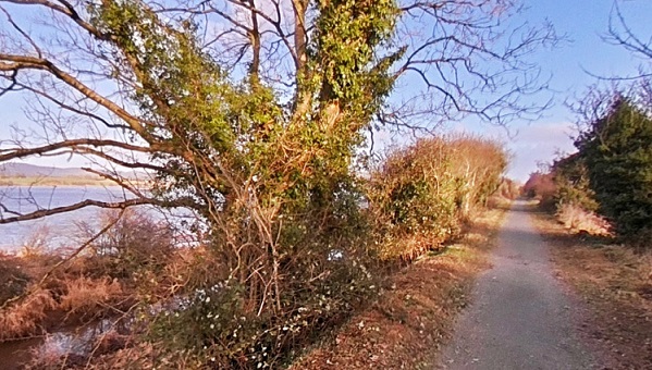
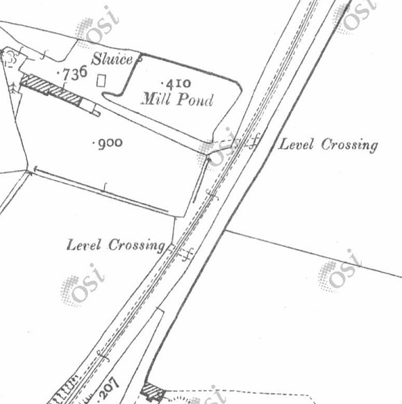
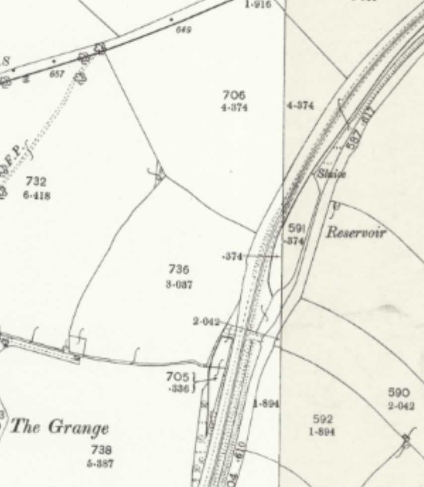
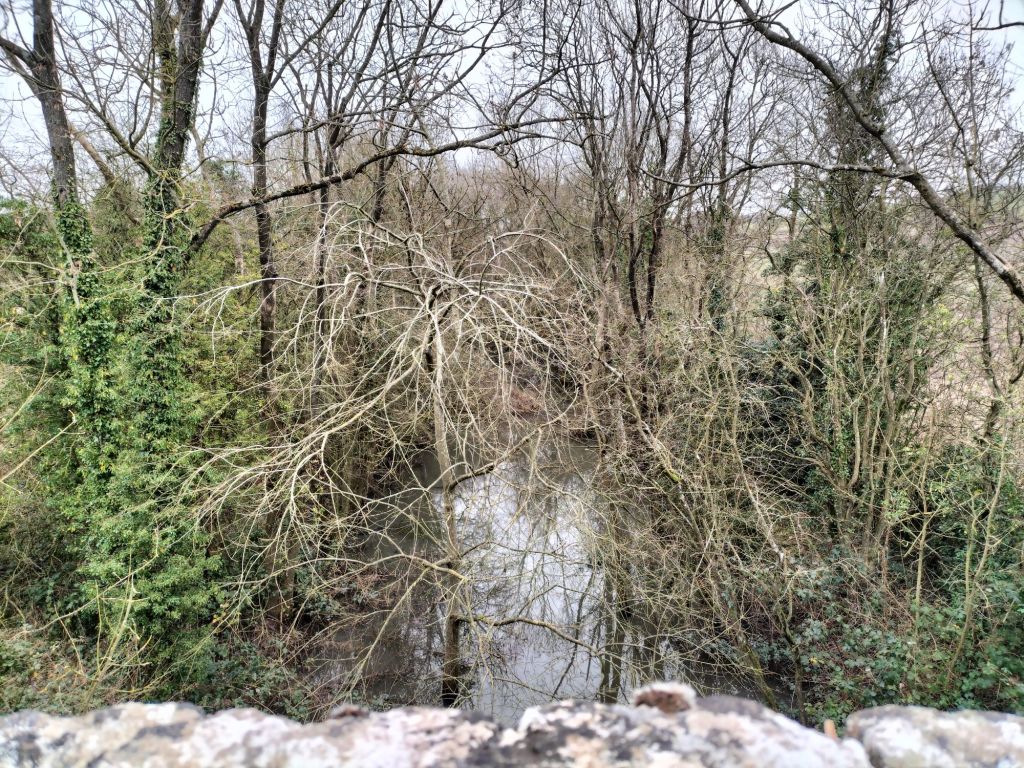
This section of the line ran North from the access road noted above. Back Shore Road crosses the old railway at a level-crossing at the top of this map extract. The stream that has followed the road North emptied into the Lough by means of a stone arch under the of railway. A photograph taken by Willie Rodgers of the stone-arched bridge carrying the old railway over the stream can be seen below. [3]
Then curving round to the Northeast, the line crossed a long embankment over part of Lough Swilly. Open water was to the Northwest of the line, a lagoon and saltmarsh prone to flooding was to the Southeast of the line. [3]
This extract from the 25″ OSi survey shows the line leaving the  embankment and curing further round to the East. [3]
The same length of the Lough Swilly Railway as shown in the three map extracts immediately above, as it appears on railmaponline.com’s satellite imagery. What was saltmarsh to the Southeast of the line has been reclaimed and is now in use as arable land. [2]
Looking Southwest along the line of the embankment in the 21st century. Back Shore Road ends today in a small unmetalled carpark and a gate into the farmland visible to the top-right of this photograph. [My photograph, 9th May 2024]
The small unmetalled carpark at the end of Back Shore Road. The route of the old railway is marked by the orange line heading out onto the embankment. [Google Streetview, July 2021]
The stone-arched bridge at the Southwest end of the embankment which carries the route of the L&LSR over the drainage stream which empties into the Lough at this point. This image was shared on the Londonderry & Lough Swilly Railway Facebook Group by Willie Rodgers on 19th November 2021. [5]
Looking Northeast along the line of the Lough Swilly Railway from a point 100 metres out along the embankment form the carpark noted above. [My photograph, 9th May 2024]

An aerial image taken by Michael Roulston in February 2021 looking Southwest along the embankment and showing the curve of the old line on its Southwestern approach can be seen by following this link: https://maps.app.goo.gl/vEEn4ViuBhW5QiTD6

A photograph taken by David Hughes in July 2020 from a point about halfway along the embankment can be found on this link: https://maps.app.goo.gl/zb85mGUaBZRqafHa6

A similar photograph taken by David Hughes on the same day shows the view along the embankment from the location of the sluice gates. The railway began to curve away from the line of the embankment at this point. The photograph can be found on this link: https://maps.app.goo.gl/o6TbpWy19muqJypu8

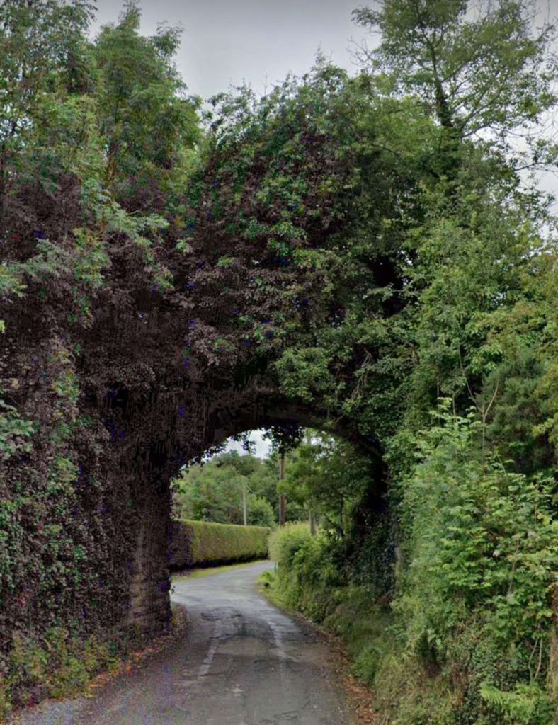
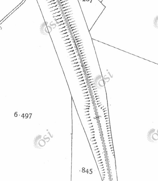
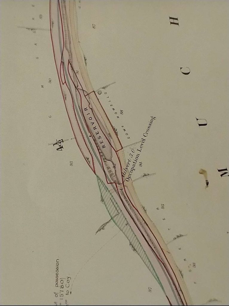
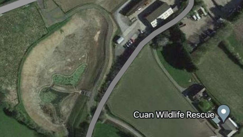
This enlarged extract from the 25″ OSI shows the old railway curving away from the straight line of the embankment. [3]
The railway curved away from the straight line of the embankment. [Google Maps, May 2024]
This view looks South from just to the North of the Northeast end of the embankment. The L&LSR can be seen curving away to the East and crossing the access road to the location of the photographer via a stone-arched bridge. [Google Streetview, September 2010]
A better image of the bridge seen above, also taken from the North. This image was shared on the Londonderry & Lough Swilly Railway Facebook Group by Willie Rodgers on 19th November 2021. [5]
The same bridge, seen this time from the South. This image was shared on the Londonderry & Lough Swilly Railway Facebook Group by Willie Rodgers on 19th November 2021. [5]
The same structure seen from further to the South along the lane. The tree line to the right of the bridge marks the line of the Lough Swilly Railway. [Google Streetview, September 2010]
The next significant location was a little further to the East where another minor road crossed the lien fo teh railway on a bridge. This enlarged extract from the 25″ OSi survey shows the location. [3]
This enlaregd extract from the railmaponline.com satellite imagery shows the same location in the 21st century. [2]
This view from the South shows the bridge parapets in place in the 21st century. The L&LSR cutting has been infilled and returned to arable use. [Google Streetview, July 2021]

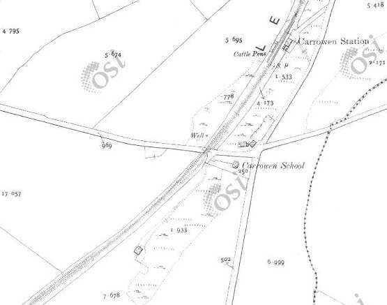
The next three extracts from the 25″ OSI survey show the line turning first to the Northeast and after a short distance reaching Carrowen Railway Station.

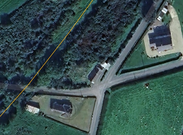
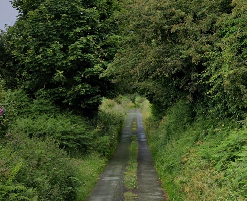
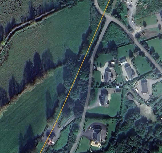
These three extracts from the 25″ OSI surveytake us as far as Carrowen Station. [3]
This extract from railmaponline.com’s satellite imagery covers the same length of line as appears in the three map extracts immediately above. [2]
When the L&LSR was in use it was bridged by a minor road which linked roads to the North and South of the line and provided access to the complex of buildings shown on this enlarged extract from the 25″OSi survey. [3]
A wider view of the same location in the 21st century as provided by railmaponline.com’s satellite imagery. Both the road and the old railway have been ploughed back into the landscape. [2]
Approaching Carrowen Railway Station, the line was carried over a road close to Carrowen School. [3]
Railmaponline.com’s satellite imagery shows the same area as covered by the map extract above. [2]
Trees appear to form an arch over the narrow road at the point where the L&LSR was carried by a bridge across the road close to the site of what was Carrowen School. [Google Streetview, July 2021]
An enlarged view of Carrowen Railway Station as shown on the 25″ OSi survey. [3]
The Station site as shown on an enlarged extract from railmaponline’s satellite imagery. The old station househas been extended out across the line of the railway. [2]
Carrowen Station Hose and platform viewed from the West. The building was not of the same design of other larger station houses that we have encountered in our journey along the line of the L&LSR. This photograph was shared on the Londonderry & Lough Swilly Railway Facebook Group by Conor Harkin on 27th April 2022 courtesy of Fahan Inch & Burt Parish. [6]
The modern private dwelling on the site of Carrowen Station House includes the original station house It is seen here viewed from the village road to the East of the L&LSR. The photograph looks along the old station approach. The extension to the right of the building sits over the formation of the old railway. [Google Streetview, July 2021]
This next extract from the 25″ OSi survey shows the old railway heading North-northeast away from Carrowen Railway Station and bridging a local road. [3]
The same length of the line as it appears on modern satellite imagery. The rail-over-road bridge was sited at the top-right of the image. The bridge has gone a a minor realignment of the road carriageway has taken place. [2]
Looking Northwest through the location of the bridge. The bridge and the line’s embankments have been removed. The orange line indicates the approximate line of the L&LSR. [Google Streetview, July 2021]
Continuing North-northeast, the L&LSR ran through two level crossing close to Drumgowan. [3]
the location of each of the crossings can easily be picked out on the modern satellite imagery of railmaponline.com. [2]
This photograph taken from the closest metalled road shows the first crossing encountered. It was about 50 t0 100 metres down the lane at the centre of the image. The approximate line of the L&LSR is shown as an orange line beyond the trees. [Google Streetview, July 2021]
From a very similar location to the last photograph but this time looking North-northeast. The line of the L&LSR crossed the field to the right of the photograph and ran through the trees which appear left of centre towards the top on the image. The track on the left of the image meets the line o0f the old railway at the first of the trees and then runs along what would have been the formation of the old railway to the coast of Lough Swilly, this can be seen on the next satellite image below. [Google Streetview, July 2021]

The next three extracts from the 25″ OSi survey show the L&LSR curving round to the East to run along the side of Lough Swilly. The earthworks of the earlier line from Derry to Farland Point can be seen to the North of the line.

The station at Farland Point opened on 12th December 1864 when the Londonderry and Lough Swilly Railway built its line from Londonderry Middle Quay railway station to a terminus at Farland Point. The L&LSR owned ferries which operated from Farland Pier. [7]

The L&LSR curved round to the East to run along the side of the Lough. Close to the flood gates earthworks from an abandoned line serving Garland pier would have been visible from trains running between Letterkenny and Derry. [3]

.

The original L&LSR line terminated at Farland Point. When the line was extended through Letterkenny and beyond the short stub to Farland Point was removed leaving only the earthworks. [3]
The line continued East alongside the sound on the South side of Inch Island which has been cut by an embankment causeway. [3]
This extract from railmaponline.com’s satellite imagery shows the same length of the L&LSR as covered by the three map extracts above. The embankment visible in the map extracts above still exists in the 21st century. Farland Pier is to the West of the embankment. [2]
Looking East along what was the line of the old railway round the curve shown on the left of the railmaponloine.com image above. [Google Streetview, September 2009]
Looking back Southwest along the curve of the old railway shown on the left of the railmaponline.com image above. [Google Streetview, September 2009]
Looking East along the line of the L&LSR which ran along the embankment beyond the gate ahead. [Google Streetview, September 2009]
Looking back through the gate from the line of the old railway towards Drumgowan (c) Roy Smyth. [Google Streetview, January 2023]
The remains of Farland Pier as they appear on Google Maps. [Google Maps, 23rd May 2024]
Looking West towards Farland Pier with Inch Castle beyond., © Oliver Dixon and shared on Geograph by him on 12th July 2013. This image is licenced for reuse under a creative commons licence (CC BY-SA 2.0). [8]

John McCarton comments on the Londonderry & Lough Swilly Railway Facebook Group: “The Londonderry and Lough Swilly Railway Company opened a railway service from Derry to Farland Point (Inch Level Wildlife Reserve today) in December 1861. From Farland Point, a paddle steamer service took train passengers across Lough Swilly, to Ramelton or Letterkenny. Paddle steamers were chartered in from existing Lough Foyle and Clyde companies to inaugurate this new service. In September 1864, the line was extended from Tooban Junction to Buncrana, with a spur to Fahan, extending Into sidings at the pier for the transportation of goods and passengers to and from the paddle steamers. The ferry service moved to Fahan in 1866, which then became the hub for the L&LSR’s passenger and freight services, to Ramelton, Rathmullan and Portsalon.” [8]

These two extracts from the OSi 25″ survey show the L&LSR running along the South side of what became Inch Wildfowl Reserve. [3]
This railmaponline.com satellite image covers the same length of the old railway as the two map extracts immediately above. [2]
Looking East along the line of the old railway about 200 metres further along the embankment, (c) Roy Smyth. [Google Streetview, January 2023]
Looking East-northeast along the line of the old railway as it curves with the embankment towards the Northeast, (c) Roy Smyth. [Google Streetview, January 2023]
Looking Northeast at a point close to the right side of the railmaponline.com satellite image above, (c) Roy Smyth. [Google Streetview, January 2023]

The next few map extracts follow the old railway heading Northeast towards Tooban Junction Station. …

These three extracts form the OSi 25″ survey show the remaining length of the embankments alongside Lough Swilly as the line heads Northeast towards Tooban Junction. After turning to the Northeast the line can be seen running on a secondary embankment to the East of that facing the sea. [3]
This extract from the railmaponline.com satellite imagery shows the length of the L&LSR covered by the three map extracts above. [2]
Looking back to the Southwest along the L&LSR formation from the Inch Wildfowl Reserve car park. The railway ran along a low embankment to the East of the main embankment and to the East of the modern walkway. [Google Streetview, September 2010]
Looking Northeast along the L&LSR formation from the Inch Wildfowl Reserve car park. The line ran, approximately, along the tree line close to the centre of this photograph. [Google Streetview, September 2010]
Looking Northeast along the L&LSR formation again. (The line ran to the right of the path ahead.)
As is evident in these last few images, the old railway was protected from the worst of the weather over Lough Swilly by a high embankment. We are closing in on the curve taking the line into Tooban Junction Station, (c) Roy Smyth. [Google Streetview, January 2023]

Inch Wildfowl Reserve

The story of the Wildfowl Reserve is told on its website: [9]

Inch Lough is a brackish lagoon cut out from Lough Swilly by embankments, and penned between Inch Island and extensive flat agricultural polders (slobs) on the mainland of County Donegal by a third long embankment.

Historically there was a large area of Lough Swilly between Inch Island and Burt, which lies at the foot of Grianan Mountain (the site of the famous Iron Age hillfort, Grianán of Aileach).  In 1836 it was proposed to claim this shallow expanse of tidal estuarine mud from the lough.  Work started around 1840 and was complete by 1859.

The first stage was the construction of the Tready Embankment across the centre of the area, from Tooban Junction near Burfoot in the east, to Farland Point in the west.  It would also serve as the route of the Londonderry and Lough Swilly Railway – a narrow-gauge line connecting Carndonagh and Derry in the north-east, with Letterkenny and Burtonport in the far west.  The line operated between 1863 and 1953.

North of Tooban was a point where the mainland was close to Inch Island, and where a causeway, the Inch Embankment, was built to link the island to the mainland.

The third stage was to construct a parallel embankment in the west, between Farland Point and the island, the Farland Embankment, or as it is now generally called, the Farland Bank.

So between these three embankments and Inch Island there was a section of water cut off from Lough Swilly, and also from the mud flats to be drained. This area would be kept as a holding tank, to receive the waters drained from the south and keep out the tidal extremes of Lough Swilly.  Thus Inch Lough was created, and over the years has become steadily less salty.

South of the Tready Embankment, between it and Grianan Mountain, all that area of Lough Swilly now isolated from the tidal waters could be drained through a complicated system of large and small drains, to create agricultural land.  This huge expanse of flat polderland is locally known as The Slobs, or more formally as Inch Level.  The drainage was not initially very successful.  Until the late 1950s the patchwork of small fields were very marshy, and included some areas of unambiguous marshland.

At that time, industrialist Daniel McDonald, started to buy up the small properties and by 1961 had amalgamated all into Grianán Estate, the largest arable farm in Ireland at around 1200ha.  The fields could then be enlarged and the drainage system re-vitalised.

There have been a few changes of hands since then.  Most notably, a consortium of businessmen bought the estate in 1980 and announced plans to drain the northern half of the lake.  A local campaign was immediately launched to resist this – mainly defending Inch Island’s status as an island, but concerned also about the threat to wildlife from the loss of half of the lake.  The consortium claimed that the scheme proved to be technically unviable, and whether or not that was the real reason, or they were overwhelmed by the strength of the opposition, they abandoned the scheme and sold up in 1989.

An Grianan Farm is now in the hands of Donegal Creameries plc., and managed as an organic dairy farm.  Parts of it are leased to local farmers.  In 2002 the National Parks and Wildlife Service took on a thirty year lease of Inch lough and its surrounding wet grasslands.  Since then, NPWS along with various stakeholders have developed the site, with ongoing work in conservation management, community involvement, and development of visitor infrastructure.  The aim now is to sustainably develop Inch Wildfowl Reserve for the future, integrating conservation with community and farming, whilst allowing limited access for the public.” [9]

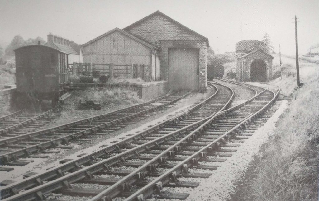
This extract from the 25″ OSi survey covers the next length of the line. Included in this extract is Tooban Junction and its station and the start of the branch to Cardonagh. [3]
An enlarged extract focussing on Tooban Junction. The L&LSR line to Derry is the more northerly of the two line leaving the right of this image. The other line is a long storage line or headshunt. [3]
This extract from the railmaponline.com satellite imagery covers the same length of the L&LSR as shown in the map extracts immediately above. It centres on the location of Tooban Junction Station. [2]
Facing Northeast along the L&LSR formation again. This time on the curve round to the location of Tooban Junction Station, (c) Roy Smyth. [Google Streetview, January 2023]
Facing East along the line of the old L&LSR through the location of Tooban Junction Station from the modern footbridge over the drainage channel. Note the signal post with two arms which stands on the station site, This is a reconstruction by Buncrana sculptor John McCarron as part of the Ghosts of Tooban Junction project, (c) Roy Smyth. [Google Streetview, January 2023]
Tooban Junction Station seen from the West. This image was shared by Donegal Railway Heritage Museum in their Facebook Page on 6th February 2020, (c) Edward Patterson
Looking West at Tooban Junction on 20th April 1953. The line to Letterkenny is to the left of the water tower, that to Cardonagh is to the right. This photograph was shared on the Fahan Inch & Burt Parish Facebook Group on 6th September 2015. [16]

The ‘Disused Stations’ website has a series of pages focussing on Tooban Junction Station. [10][11][12][13] These pages include a history of the station and a number of photographs of the station from various sources. Click here to visit the first of these pages.

Ernie’s Archive includes a number of photos of the station. [14] Click here to access these images.

Wikipedia notes that “the station opened on 9th September 1864 when the Londonderry and Lough Swilly Railway built their line from Londonderry Middle Quay to Farland Point. It closed for passengers on 23th October 1935. Freight services continued until 10th August 1953.” [17]

We take a break at Tooban Station and await the next train!

References

  1. https://en.m.wikipedia.org/wiki/Londonderry_and_Lough_Swilly_Railway, accessed on 30th April 2024.
  2. https://railmaponline.com/UKIEMap.php, accessed on 1st May 2024.
  3. https://osi.maps.arcgis.com/apps/webappviewer/index.html?id=bc56a1cf08844a2aa2609aa92e89497e, accessed on 5th May 2024.
  4. Dave Bell and Steve Flanders; The Londonderry and Lough Swilly Railway: A Visitor’s Guide; County Donegal Railway Restoration Society.
  5. https://www.facebook.com/groups/788818974978955, accessed on 18th May 2024.
  6. https://www.facebook.com/photo?fbid=1713862078953969&set=gm.1295963820931132&idorvanity=788818974978955, accessed on 22nd May 2024.
  7. https://en.m.wikipedia.org/wiki/Farland_Point_railway_station, accessed on 23rd May 2024.
  8. https://www.facebook.com/share/p/Piq7PPiWx22ujqFV/, accessed on 23rd May 2024.
  9. https://www.inchwildfowlreserve.ie/history, accessed on 23rd May 2024.
  10. http://disused-stations.org.uk/t/tooban_junction/index1.shtml, accessed on 27th May 2024.
  11. http://disused-stations.org.uk/t/tooban_junction/index.shtml, accessed on 27th May 2024.
  12. http://www.disused-stations.org.uk/t/tooban_junction/index2.shtml, accessed on 27th May 2024.
  13. http://www.disused-stations.org.uk/t/tooban_junction/index3.shtml, accessed on 27th May 2024.
  14. https://www.flickr.com/search/?text=tooban+junction, accessed on 27th May 2024.
  15. https://www.facebook.com/photo/?fbid=2645067492196142&set=a.1224552917580947, accessed on 27th May 2024.
  16. https://www.facebook.com/fahaninchburt/photos/a.648557531950952/648562385283800/?type=3, accessed on 27th May 2024.
  17. https://en.wikipedia.org/wiki/Tooban_Junction_railway_station, accessed on 27th May 2024. However, note comments made in response to this article by Martin Baumann: “The Derry to Buncrana line saw passenger services on bank holidays after regular services had ceased. The last day this happened was 6th September 1948. … Freight traffic ceased on 8th August 1953, not the 10th but it was possible to travel on freight services as the Swilly had no Goods Brake Vans so a Passenger Brake with some seats was always in the formation.”

The Lough Swilly Railway continued. … Letterkenny to Derry – Part 1

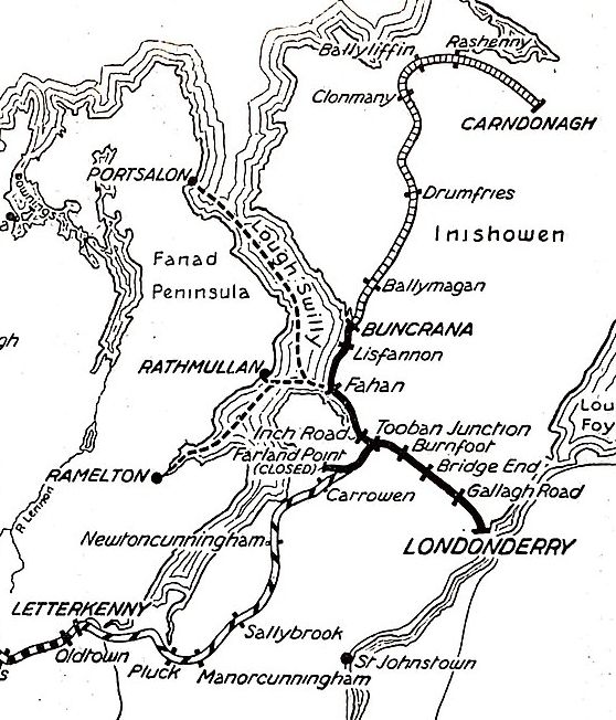
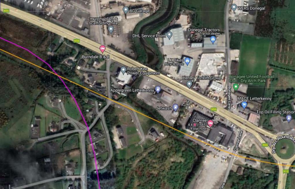
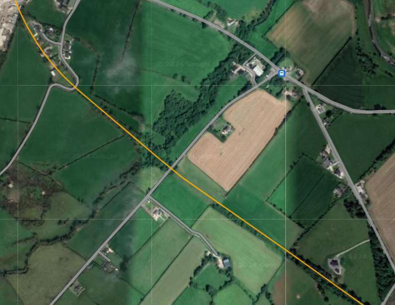
Letterkenny once had two railway stations immediately adjacent to each other. One was the terminus of the County Donegal Railways Strabane to Letterkenny branch. The other was a through station on the Lough Swilly (when operation in the first half of the 20th century it’s formal title was the ‘Londonderry & Lough Swilly Railway’).

The two railway stations in Letterkenny lay side by side. That to the North was the terminus if the County Donegal Railways branch which connected Letterkenny to Strabane. That to the South was the Lough Swilly station through which passed trains between Burtonport and Derry. OSi 6″ to 1 mile last series. [3]
The same area as shown on the railmaponline.com satellite imagery. Contrary to what appears on the image, both railway lines ran on the South side of Ramelton Road. That shown in Orange is the Lough Swilly line. [4]

In an East-Southeast direction, the two companies’ lines ran parallel for some distance, before the Co. Donegal line headed away to the South through Convoy and Raphoe before crossing the border at Lifford and meeting the other Co. Donegal lines at Strabane. The Loch Swilly found its way to Derry via Tooban Junction where a significant branch line to Buncrana and Cardonagh left the line to Derry.

To the West, the Lough Swilly’s Burtonport Extension Railway meandered across the moors and between small villages nearer the coast.

Three articles cover the Strabane to Letterkenny branch of the Co. Donegal Railways. They can be found on the following links. ….

Co. Donegal Railways, Ireland – Part 4 – Strabane to Letterkenny (Part A – Strabane to Raphoe)

Co. Donegal Railways, Ireland – Part 5 – Strabane to Letterkenny (Part B – Raphoe to Convoy)

Co. Donegal Railways, Ireland – Part 6 – Strabane to Letterkenny (Part C – Convoy to Letterkenny)

The Burtonport Extension of the Lough Swilly is covered in four other articles which can be found on these links. …

The Burtonport Extension of the ‘Londonderry & Lough Swilly Railway’ – Part 1

The Burtonport Extension of the ‘Londonderry & Lough Swilly Railway’ – Part 2

The Burtonport Extension of the L&LSR (Londonderry & Lough Swilly Railway) – Part 3 – Cashelnagor Railway Station to Barnes Gap

The Burtonport Extension of the L&LSR (Londonderry and Lough Swilly Railway) – Part 4 – Barnes Gap to Letterkenny. …

The Lough Swilly’s line between Derry and Letterkenny was built in stages and included a change of track gauge from 5ft 3in to 3ft.

The railway was initially planned as the Derry and Lough Swilly Railway Company when an application for incorporation was filed in 1852,  … The company opened its first line, a 5 ft 3 in (1,600 mm) link between Derry and Farland Point, on 31st December 1863. A branch line between Tooban Junction and Buncrana was added in 1864 and much of the Farland Point line was closed in 1866.” [1][2: pxiv]

Wikipedia’s history of the railway company goes on to say that “in 1883, the 3 ft (914 mm) narrow gauge Letterkenny Railway between Cuttymanhill and Letterkenny was opened and the L&LSR connected with it by reopening the Tooban Junction – Cuttymanhill section of its Farland Point line. The L&LSR worked the Letterkenny Railway, and in 1885 it converted its track from 5 ft 3 in (1,600 mm) gauge to 3 ft (914 mm) narrow gauge to enable through running. In 1887, ownership of the Letterkenny Railway passed to the Irish Board of Works, which continued the agreement by which the L&LSR operated the line.” [1][2: pxiv & p3]

Carndonagh was reached by an extension completed in 1901 and Burtonport by a one completed in 1903. Both lines were constructed as joint ventures with the UK Government, with ownership and liabilities shared between the two parties. During this period the company did not make a profit, and struggled to meet its debts.” [1][2: p2 & p3]

The Lough Swilly Railway between Letterkenny and Derry in 1926. © Public Domain. [1]

Letterkenny to Newtowncunningham

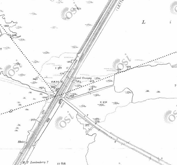
Letterkenny to Newtoncunningham. The L&LS railway is shown on this extract from OSi mapping of the mid-20th century. [3]

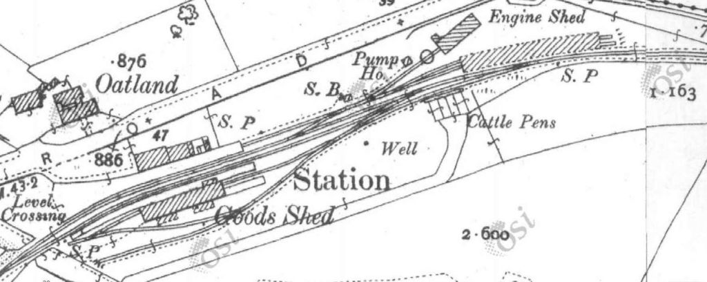
The first map extract from OSi mapping which appears close to the top of this article shows the Co. Donegal and the Lough Swilly stations in Letterkenny. The 6″to 1 mile series as digitised is not the clearest mapping. An earlier 25″ to 1 mile series shows only the Lough Swilly line but is of a higher quality.

These first two 25″ OSi map extracts show only the Lough Swilly Station and line. When the Co. Donegal branch was constructed the Ramilton Road had to be realigned northward.
Letterkenny & Burtonport Extension Railway (L&BER) No. 3 was a 3ft gauge 4-6-0T, built by Andrew Barclay & Sons Co. in 1902 for the Letterkenny and Burtonport Extension Railway. The line was operated by the L&LSR. No.3 was scrapped in 1954. It is seen here heading from Burtonport to Letterkenny, © Courtesy of Trainiac on Flicker (Public Domain). [8]

Ernie’s Railway Archive on Flickr has a range of photographs of the L&LS Letterkenny Railway Station site from the 1950s, the links are embedded here below, click on each link to see the image in Ernie’s Railway Archive on Flickr:

https://flic.kr/p/2nMqBvu – The L&LSR Station site from the East in 1952. The carriage shed is closest to the camera on the right of the image. The locomotive shed and turntable are hidden behind the carriage shed. At the centre-top of the image, the Goods Shed can be seen.

https://flic.kr/p/2nM8xYs – The Goods Yard of the L&LSR in 1952. Beyond wagons L&LSR No. 124 and L&BER No. 73 the Goods Shed and the passenger station building can be seen.

https://flic.kr/p/2nWyB5y – The L&LSR Goods Yard in 1952. The side elevation of the Goods Shed is visible beyond the wagons in the yard. Prominent in the picture is L&LSR Wagon No. 71.

https://flic.kr/p/2nCR8dg – L&LSR No. 12 is featured in this image from 1952. No. 15 is just poking its nose into the shot on the left.

https://flic.kr/p/2kHNdD9 – L&LSR No. 8 is being turned on Letterkenny’s turntable on 27th June 1952.

https://flic.kr/p/JoWHRY – L&LSR No.15 sits in front of Letterkenny WaterTower in 1953.

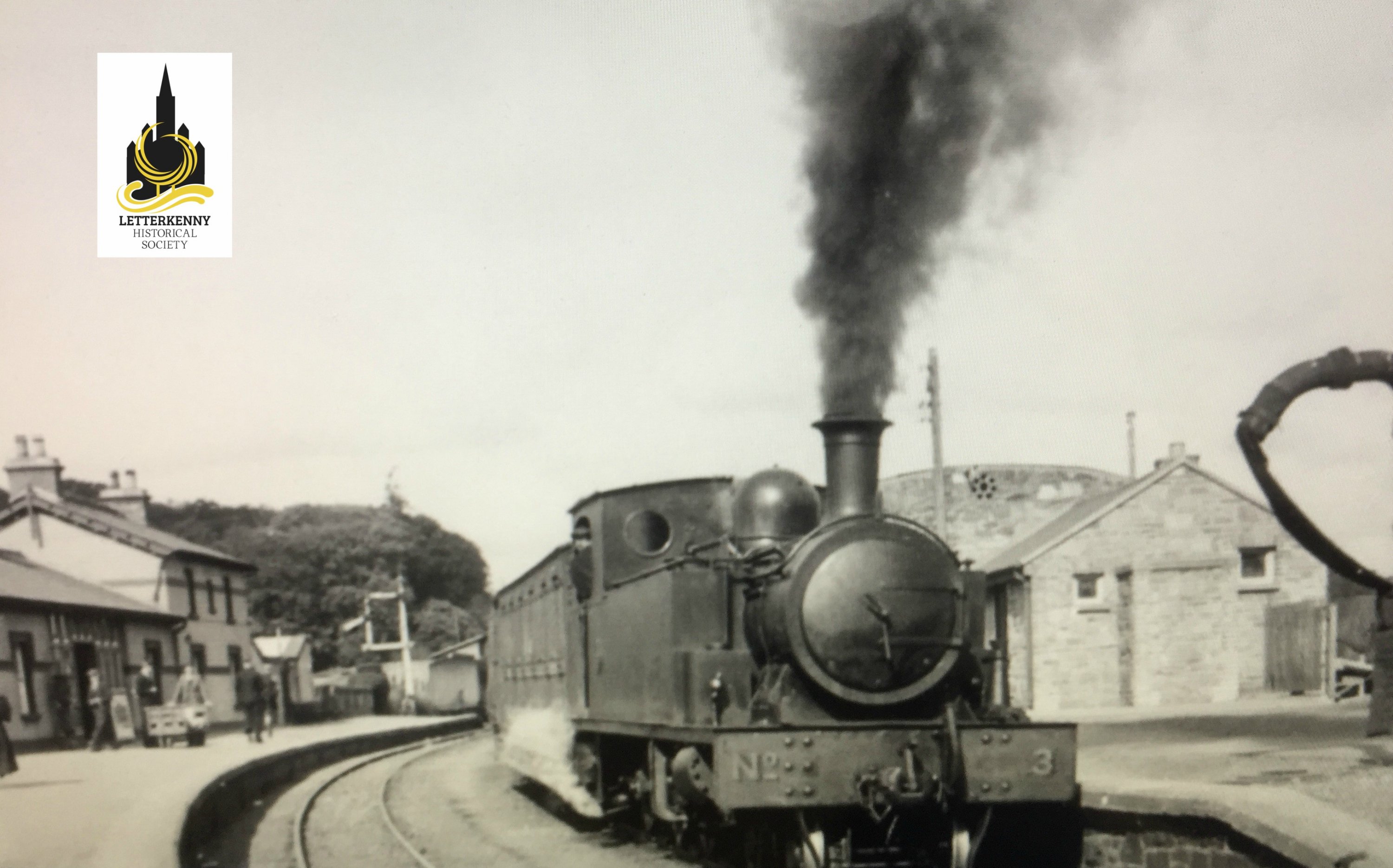
https://flic.kr/p/BWoyiF – L&LSR No3 at Letterkenny. On the left, the image is framed by the wall of the Goods Shed. The crossing gates at the West end of the station are visible beyond No. 3’s train. The passenger facilities are on the right. Note the coach acting as a brake van for the train. (c) JW Armstrong/ARPT

https://flic.kr/p/BvajsP – L&LSR No. 12 in the Engine Shed at Letterkenny, (c) JW Armstrong/ARPT

https://flic.kr/p/2ma5Lo3 – The L&LSR Station at Letterkenny on 1st July 1959 after the rails had been lifted. The Goods Shed door is closed (on the left) and the station buildings are on the right.

https://flic.kr/p/2k1hGvQ – The L&LSR operated a daily goods service by lorry after the closure of the line. A company rail lorry bearing the number plate IB7024 is shown standing where trains would once have passed, adjacent to the station building at Letterkenny. The photograph was taken on 23rd August 1954.

Other photographs of Letterkenny’s L&LSR railway station can be found on Flickr or elsewhere on line:

The last engines to be built for the Swilly were a pair of extraordinary 4-8-4Ts, weighing 58 tons each. No 6, with LSR diamond on the tanks, is outside Letterkenny shed on 15 June 1948. This image was shared on eBay [5]
L&LSR No. 3 at the head of a train from Derry at Letterkenny Station, either heading for Burtonport or terminating at Letterkenny. The image was shared by Letterkenny History on their webpage. [6]
Plenty to see in this shot at Letterkenny. Locomotive No. 12 is facing the photographer and a CDR engine is in the background. Shared by Kerry Doherty on the L&LSR Facebook Group on 1st February 2021. [7]
A goods train has just arrived from Derry in June 1950, © John Edgington c/o Pendragon Collection and shared on the Donegal Railway Heritage Museum Facebook Page. [9]
The L&LSR’s Letterkenny Station, seen from the Northeast. Either this train has just arrived from Burtonport or is setting off for Derry. This image was shared by Gabe J. McTuile on the Letterkenny Community Heritage Facebook Group on 19th January 2017. [10]
The two Letterkenny Railway Stations. The terminus of the Strabane to Letterkenny Branch of the Co. Donegal Railways Joint Committee is on the left. The L&LSR station which sat on the line between Derry and Burtonport. This image was shared on the Donegal County Museum Facebook Page on 20th February 2013. [11]
Another view of the two station buildings in Letterkenny. This image was shared by Keiran Kelly on the Letterkenny Community Heritage Facebook Group on 13th October 2014. [12]

These next images show the railway station buildings in Letterkenny after the closure of both lines.

The remains of both station buildings can be seen at the centre of this aerial image. There  are quite a few of the Lough Swilly Bus Company’s fleet of buses visible. This image was shared by Gabe J. McTuile on the Letterkenny Community Heritage Facebook Group on 18th June 2016 . [13]
The Co. Donegal terminus in Letterkenny is now repurposed as the passenger facilities for the town’s bus station. My photograph, 29th April 2023.
The length of the two lines between the stations and Port Bridge, superimposed on Google Maps satellite imagery. [April 2023]
Leaving the Station site, the two railway lines ran parallel to each other. Both lines crossed the old Port Road by means of girder bridges with stone abutments. The lines then crossed the River Swilly by means of lattice girder bridges alongside the road bridge. After which, the Co. Donegal line rose above the L&LSR, turning South as it bridged the L&LSR line. [13]
The North abutment of one of the bridges which carried the two lines over the Port Road. © Kerry Doherty. [17, May 2020]
Looking ahead along the line of the two railways towards the River Swilly. The remaining abutment is alongside the camera. The plaque which can be seen in the foreground close to the abutment illustrates what the bridges would have looked like, © Kerry Doherty. [17, May 2020]
The plaque mentioned above, © Kerry Doherty. [17, May 2020]
Port Bridge, Letterkenny, seen from the South, presumably before the construction of the Co. Donegal Railway Structure.  [14]
An extract from the 1st edition 6″ OSi mapping which shows just the road bridge. [15]
The same location after the construction of the L&LSR line from Derry to Letterkenny as it appeared on the 25″ OSI mapping.. [15]
The same location once more. This is an extract from the last 6″ edition of the OSi mapping. [15]
A modern aerial view of Port Bridge (seen from the downstream side) and the Polestar roundabout. This image was shared by Gabe J. McTuile on the Letterkenny Community Heritage Facebook Group on 1st February 2017. [16]
Looking Northwest along the N56 towards the Polestar roundabout. The modern bridge sits directly over the location of the old railway bridges scanning the River Swilly. [Google Maps, April 2020]
This extract from the 25″ OSi mapping which predated the construction of the CDR branch. The old main road to Derry runs parallel to the railway line to the North. Another road rises on an embankment to cross the L&LSR. [15]
The same location on the last 6″ OSi survey. The embankment has been shifted to accommodate the CDR branch. [15]
Approximately the same area as covered by the 25″ extract above as shown on the railmaponline.com satellite imagery. The road alignment shown in the OSi extracts above remains. The bridge over the two lines has been partially infilled. [4]
The embankment highlighted above is to the right of this image. The area adjacent to the white van is the bridge location. The area under the bridge has been altered to act as garage space. This image is the view westward from the modern N56.  [Google Street view, April 2023]

Dave Bell and Steve Flanders describe the use of the bridge arches in the 1980s like this: “The present owner of the filling station has made good use of the bridge by bricking up one side and building a garage against the other. In effect he now has a garage with three bays, the roof of which is actually the side road.” [18: p47] There are two pictures of the arched bays in Bell and Flanders book.

Kerry Doherty also very kindly supplied this photograph which shows the arches of the old bridge inside the garage facility, (c) Dave Bell. [17]

A short distance to the South East the CDR branch crossed the Lough Swilly and turned away to the South.

The next extract from the 25″ OSi survey. [15]
The immediate area of the bridge carrying the CDR over the Lough Swilly line as shown on the last 6″ OSi mapping.. [15]
Approximately the same area as covered by the 25″ extract above. [4]
As we have already noted, after crossing the River Swilly the two railway lines ran approximately parallel to each other. The Co. Donegal branch line climbed gradually until it was able to bridge the Lough Swilly line and head away to the South. By the time this picture was taken the Lough Swilly line had closed and had been lifted. This picture was kindly supplied by Kerry Doherty. It shows Co. Donegal Railway No. 5 Drumboe at the head of a goods train in 1959, © J.G. Dewing, Color-rail. [17]

A short distance to the East of the over bridge the Lough Swilly line crossed another road at a level crossing.

The site of the level-crossing as shown by Google Maps [May 2024]
At the site of the level-crossing, this view looks back towards Letterkenny along the line of the old railway. [Google Streetview, August 2021]
Also at the level-crossing this view looks ahead to the Southeast along the line of the railway. [Google Streetview, August 2021]

A few hundred metres to the Southeast the line crossed Clanree Lane at the level.

The old railway ran approximately along the line of parked cars in the Clarence Hotel carpark in this Google Maps satellite image, across Clanree Lane and through the house which has been built over the old railway. [Google Maps, May 2024]
Looking back along the line of the Lough Swilly Railway from the location of the level-crossing on Clanree Lane. [Google Streetview, August 2021]
Looking East from the lpcation of the level-crossing on Clanree Lane. The house has been built over the old formation. [Google Streetview, August 2021]
The next length of the old railway as shown on the 25″ OSi survey. [15]
The same length of the Lough Swilly Railway as it appears on railmaponlin.com’s satellite imagery. The old railway formation is buried under the earthworks of the modern N13 road. [4]
This next extract from the OSi 25″ survey shows the old road to Derry passing under the Lough Swilly. [15]
The route of the Lough Swilly Railway continues to be located under the earthworks of the N13 dual-carriageway. [4]
This next OSi extract (from the 25″ survey shows the line meandering to the North. [15]
The N13 continues to follow the route of the old railway. [4]
The 25″ OSi survey again. … The line continues to follow the contours as it curves around higher land. [15]
Railmaponline.com continues to show the line of the Lough Swilly Railway in orange. [4]
This next extract from the OSi 25″ survey shows the Lough Swilly Railway crossing the old main Road by means of a bridge and continuing to cut e round towards a southerly alignment. [15]
For much of this extract from railmaponline.com the route of the old railway is followed by the N13. However close to the bottom-right of the extract the route of the Lough Swilly Railway turns South away from the modern N13. [4]
Travelling South toward Pluck, the line ran along the West side of the old road to Derry. [15]
Railmaponline.com’s satellite imagery shows that the route of the old line is still marked by hedge lines which mark the old boundaries of railway land. [4]
On the approach to Pluck Station the line bridged a narrow lane before curving round into the station.When the line was built the lane providing access to the station was diverted to allow it to bridge the line. The bridge is visible in the bottom-right of the extract. [15]
The modern satellite imagery shows that the road layout around Pluck Station is little changed. [4]
Looking East along the minor road shown in the top half of the map extract and satellite image above. The bridge abutments of the railway bridge crossing the road remains. [Google Streetview, August 2021]
An enlarged extract from the 25″ OSi survey showing Pluck Station. [15]
The same location as it appears on Google Maps. The original station building at Pluck is now in private hands and much extended/altered. [Google Maps May 2024]
Pluck Station building in 1901, seen from the North [19]
The much altered and extended building that was once Pluck Station building, seen from the North. [Google Streetview, April 2011]
Pluck Station railway bridge seen from the road to the West of the structure. The road looped round over the bridge and provided access to the Station from the South. [Google Streetview, April 2011]
To the Southeast of Pluck Station, after passing under the station bridge, the Lough Swilly Railway crossed a culverted stream and a narrow road. [15]
The same area as shown on the map extract above. The orange line represents the route of the Lough Swilly Railway. Field boundaries and hedgerows delineate the route on the ground. [4]
To the Southeast of Pluck Station the railway crossed a narrow lane by means of a stone-arched bridge. This image shows the bridge from the North. [Google Streetview, July 2021]
This next extract from the OSi 25″ survey shows the line continuing in a southeasterly direction and crossing over a further road by means of ankther stone-arched bridge. Two roads would have crossed the line in short succession had the most easterly of these not been diverted. [15]
The railmaponline.com satellite imagery shows the heavily wooded embankment which once carried the railway. [4]
Looking North though the bridge which carried the old railway over the minor road at the top left of the extracts above. [Google Streetview, July 2021]
Looking Southeast along the minor road which was diverted as part of the construction of the Lough Swilly Railway. The railway embankment is on the left of this image and the bridge in the photograph above is behind the camera to the left. [Google Streetview July 2021]
The line then curved round through East to a east-northeastly direction. A further road crossed the line in the bottom-right of this extract. [15]
The satellite image shows that the line has been ploughed back into the landscape over much of the length covered in these extracts. Towards the right of this extract, a farm track can be seen following the line of the old railway. [4]
Looking back along the line of the Lough Swilly Railway to the West. The farm track sits on the line of the old railway. [Google Streetview, July 2021]
The road mentioned in the satellite image and the map extract above is shown on the left side of this next extract from the OSi 25″ survey. A further road appears at the right of this extract. When the line was built that road was diverted so as to be able to bridge the line. [15]
From the road on the left of these extracts a further length of the old railway has been ploughed back into stable land. At the third point in this image the route of the old line is once again shrouded by trees. As can be seen here and below, the road diversion remains in place but the cutting appears to have been infilled and there is no longer any evidence of the bridge over the railway. [4]
Looking ahead from the road on the left of the two extracts above, facing East along the line of the old railway. The line ran to the right of the trees behind the black farm building. It crossed this minor road on the level. [Google Streetview, July 2021]
A Streetview image showing the road at the right of the map and satellite images above. The Lough Swilly Railway passed under the road at this location. As noted above there is no evidence except for the road alignment that the railway was present. [Google Streetview, July 2021]
The sinuous curving of the line continues on this next extract as the line continued to cross open farmland. The road at the left of this image is that at the right of the last map extract. [15]
Even without the orange line provided by railmaponline.com, the route of the old railway would be easy to pick out. [4]
The line then entered Manorcunningham Station. [15]
This is the same area as shown on the map extract above. The route of the old Letterkenny to Strabane road shows up as a grey line on the satellite imagery. The modern road was constructed long after the closure of the railway. [4]
This is the point at which the old main road leaves the modern road. Road traffic ran across the North side of the railway station and then turned sharply to the South to cross the line at the East end of the station. [Google Streetview, July 2021]
This enlarged extract from the 25″ OSi survey focusses on Manorcunningham Railway Station. [15]
This satellite image shows the same area as that covered by the map extract above. [4]
Manorcunningham Railway Station in the first half of the 20th century. [20]
A similar view of the Railway Station as it appeared in the 1980s. This image was included in Dave Bell and Steve Flanders book: The Londonderry and Lough Swilly Railway: A Visitor’s Guide and used by kind pe
The old station forecourt as seen from the modern N14. [Google Streetview, July 2021]
An enlarged view of the old Manorcunningham station building in the 21st century. [Google Streetview, July 2021]
A better view of the station building. This image was shared on the Donegal Railway Heritage Museum Facebook Page on 25th December 2021. [21]
A modern view of the platform side of Manorcunningham Station. [Google Streetview, July 2021]
The old main road ran on the North side of the station and railway line and at the end of Manorcunningham station site, turned sharply to the South passing under the railway. The abutments of the bridge carrying the railway over the road can still be found by following the old main road where it diverts from the modern N14. [My photograph, 10th May 2024]
A further road crossed the line close to Drumoghill. [15]
This extract from railmaponline.com satellite imagery covers a similar area to the map extract above. The Lough Swilly Railway’s route now runs Northeast in a straight line. There is no sign of the short viaduct which spanned both river and road as can be seen in the enlarged map extract below. [4]
This enlarged extract from the OSi 25″ survey shows the erstwhile viaduct close to Drumoghill. [15]
Looking Southeast along the line of the minor road approaching Drumoghill through the location of the old railway viaduct. [Google Streetview, July 2021]
Remains of the viaduct which crosses the stream. The section over the road has been removed. This and the following three photographs were shared on the Londonderry and Lough Swilly Railway Facebook Group by Willie Rodgers on 13th December 2021. [23]
Three photos taken in sequence looking and walking Northeast along the L&LSR from the location of the old viaduct shown on the enlarged map extract above. These pictures were all shared on the Londonderry and Lough Swilly Railway Facebook Group by Willie Rodgers on 13th December 2021. [23]
After Drumoghill, the Lough Swilly Railway continues Northeast over open farmland. [15]
Approximately the same area as shown on the map extract above. A green lane marks the line of the old railway. Hedges mark the extent of railway land. [4]
Turning further towards the North, the line ran to the East of Tullybogly. [15]
The Lough Swilly Railway passed beneath a minor road as it travelled North. [4]
Looking East along the lane which bridged the Lough Swilly Railway to the South of Tullybogly. The road can bee seen to rise and then fall away quickly after crossing the old line. [Google Streetview, July 2021]
The line continued Northeast passing close to Monclink where there was a single siding. [15]
A similar area as covered in the map extract above. A racetrack has been built over the line of the old railway at Monclink (Manor Race Track). [4]
This next extract from the OSi 25″ survey shows the line curing round towards the East and entering Sallybrook Station. [15]
The same length of the Lough Swilly Railway as shown on the railmaponline.com satellite imagery. [4]
An enlarged extract from the 25″ OSi mapping showing the Sallybrook Station site and the adjacent creamery. The road crossing ran through the heart of the station site at level, with the goods shed to the East of the road and passenger facilities to the West of the road. [15]
Approximately the same location as the enlarged extract from the OSi mapping showing the station location. [4]
Sallybrook Station House, seen from the North in July 2021. The brick out building was built on the platform after closure of the line. [Google Streetview July 2021]
Sallybrook Station as illustrated in Dave Bell and Steve Flanders book: The Londonderry and Lough Swilly Railway: A Visitor’s Guide; County Donegal Railway Restoration Society and used by kind permission of Steve Flanders and the Donegal Railway Heritage Museum. The two images on the right show the station as it was in 1953, © H.V. Casserley. Those on the left show the s[18: p41]

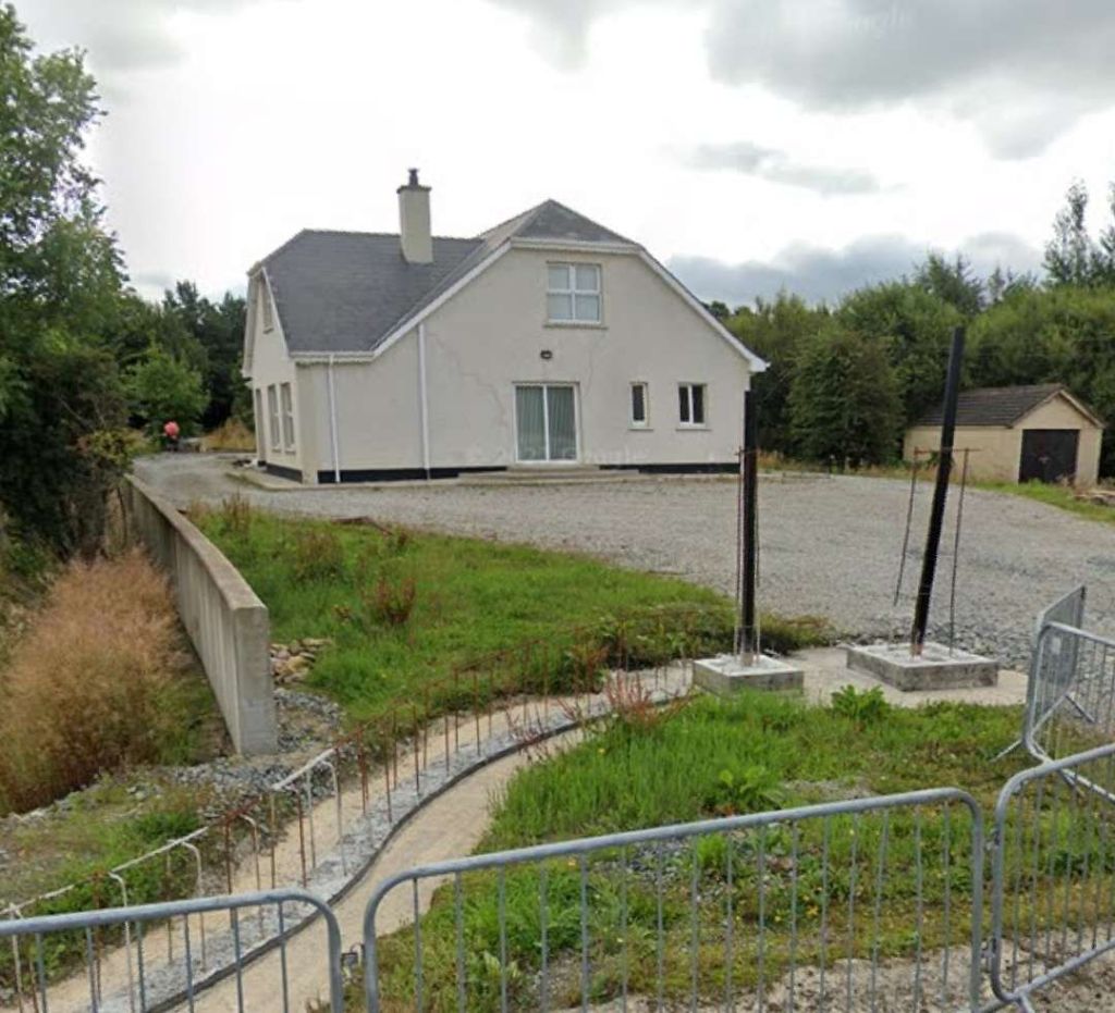
Anticipating that the Sallybrook Station House would’ve been fully renovated, we drove down the access road and discovered that no further work had been undertaken since the July 2031 photo was taken. Two pictures of the building are included here.

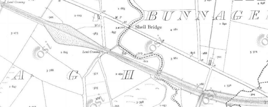
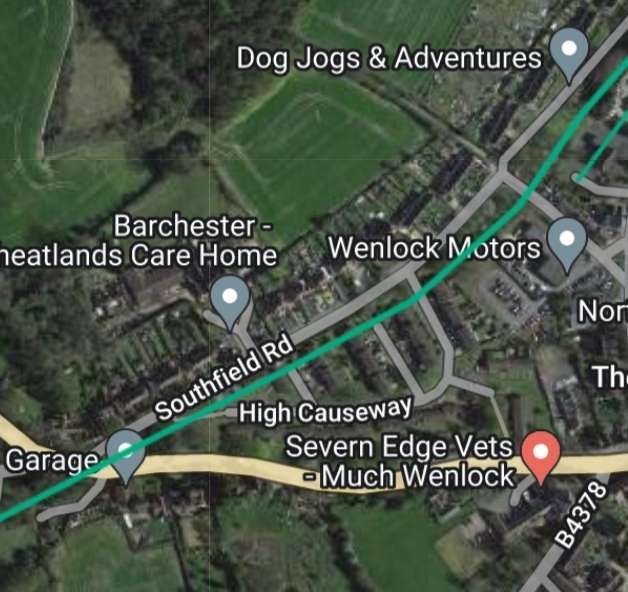
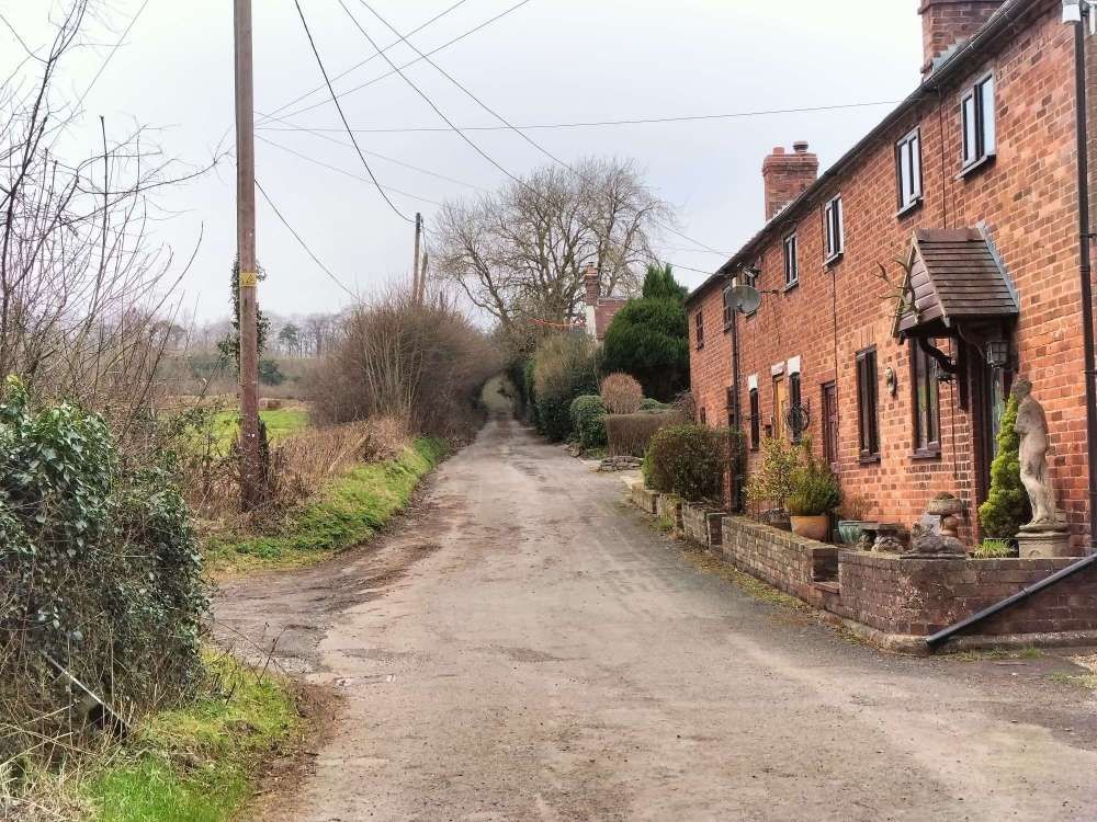
The station forecourt side of Sallybrook Station building, [My photograph, 10th May 2024]
Looking West along the line of the Lough Swilly Railway along the platform side of the Station building. [My photograph, 10th May 2024]
Looking Northwest from the minor road across the level-crossing at Sallybrook Station. [Google Streetview, July 2021]
Looking ahead, East, at Sallybrook Station, towards Newtoncunningham. [Google Streetview, July 2021]
The next extract from the 25″ OSi survey shows the length of the line immediately yo the East of Sallybrook Station. Land levels are such that the Lough Swilly Railway [passed over the next road. [15]
Google Maps shows the same location in the 21st century. [Google Maps, 15th May 2024]
Looking North along the minor road which appears in the map extract and the image above. The trees to the right and left of the road mask the embankment which carried the old railway. The bridge at this location has been removed. [Google Streetview, October 2021]

This next series of extracts from the 25″ OSi survey shows the Lough Swilly Railway crossing opens country between Sallybrook Station and Newtoncunningham Station.

The seven map extract above show the Lough Swilly Railway traversing open country/farmland in a generally Northeasterly direction. [15]
This satellite image from Google Maps shows that same length of the line as covered by the seven extracts immediately above. Field boundaries remain as they were at the time of the 25″ OSi survey. Over parts of this length of the line, hedgerows which used to flank the old railway have disappeared. [Google Maps, 16th May 2024]
This next extract from the 25″ OSi survey shows the point at which Castleblaugh crossed the line. [15]
A similar area to that shown on the map extract immediately above as it is shown on Google Maps satellite imagery in the 21st century. [Google Maps, 16th May 2024]
Looking East along Castleblaugh, the only indication of the old railway at this point is the crest in the road alignment at the point where the road bridged the line. [Google Streetview, July 2021]

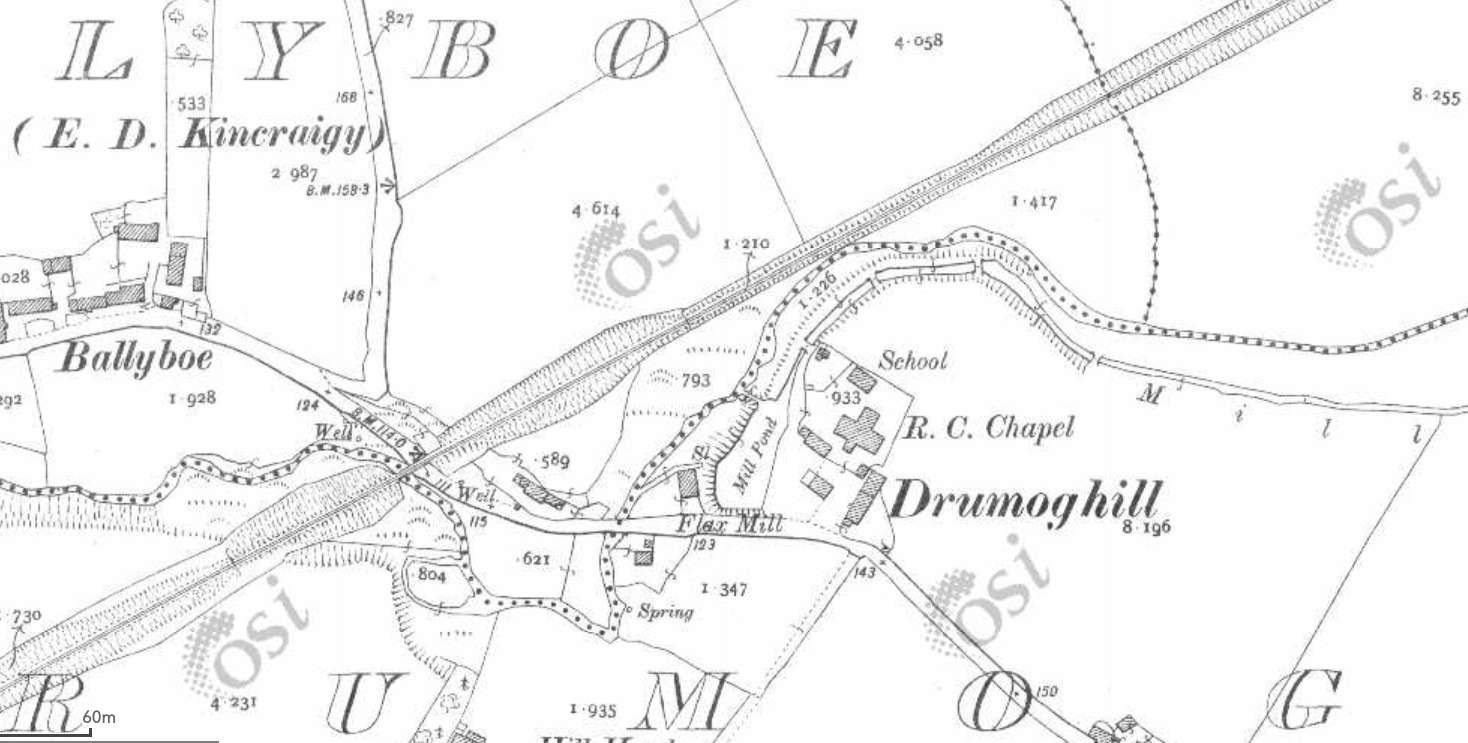
From Castlebaugh heading North to Milltown much of the old railway formation has been ploughed back into the landscape. The next few 25″ OSI survey extracts show the line as it was.

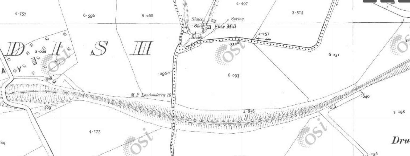
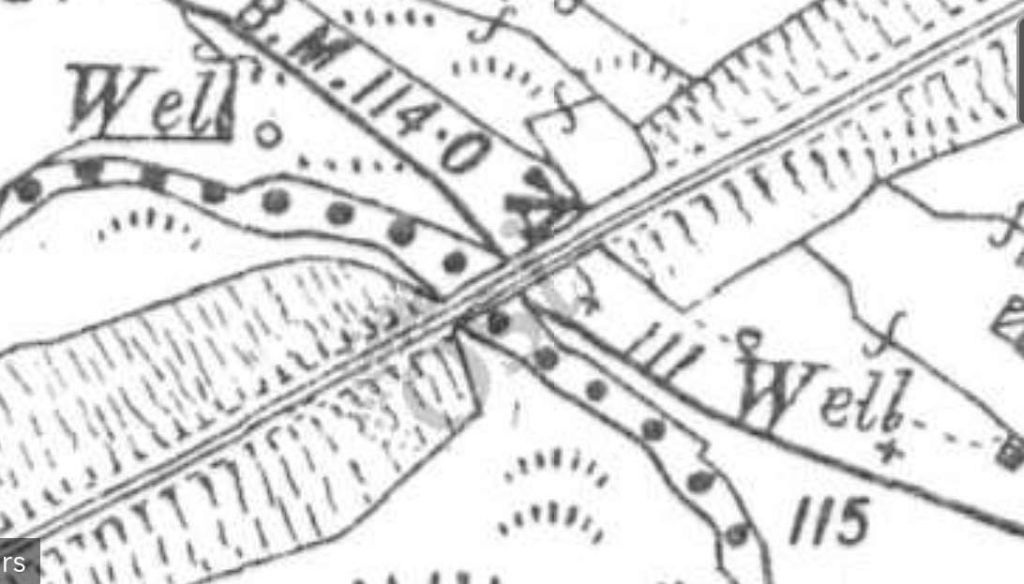
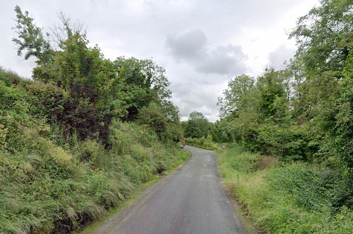
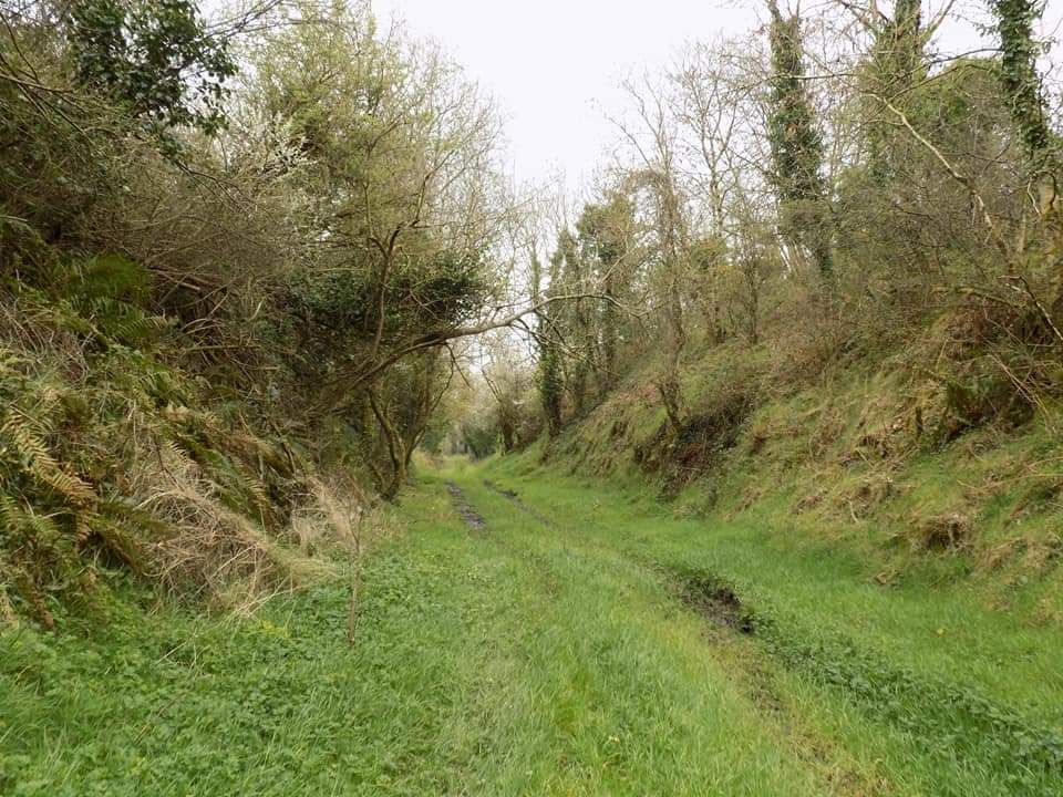
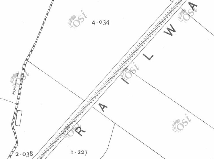
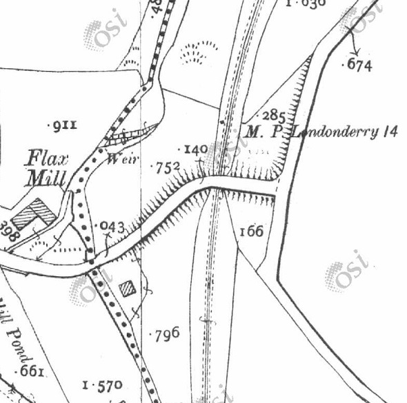
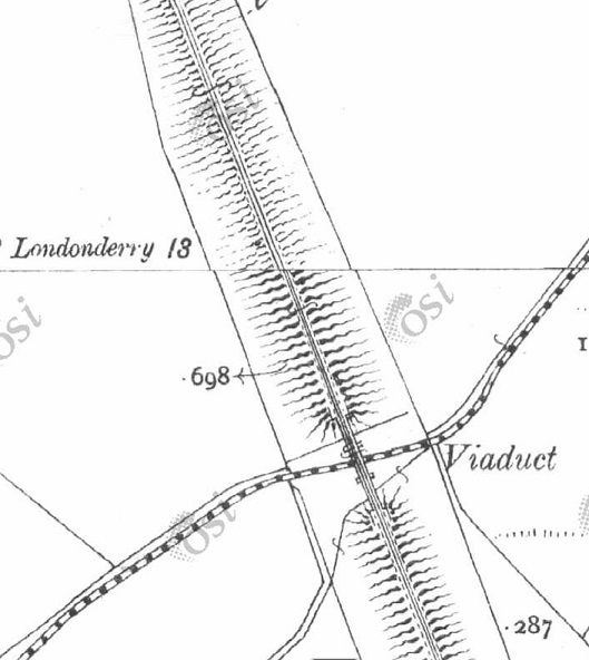
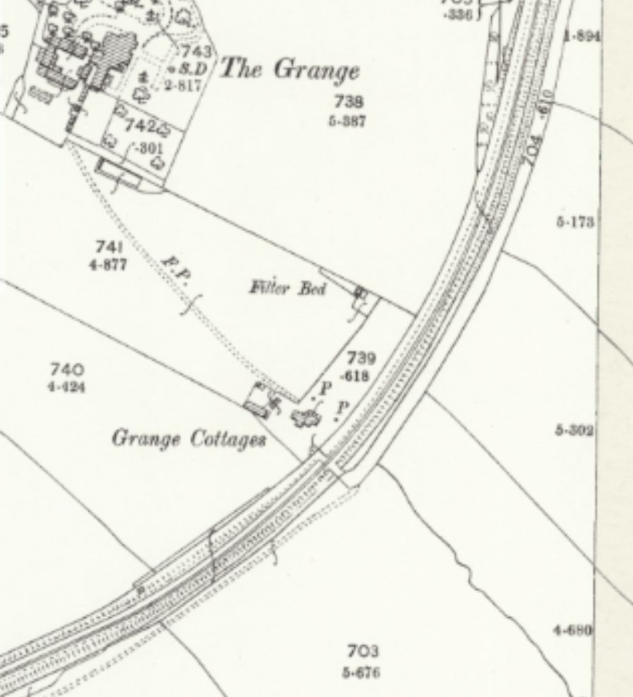
The eight extracts from the 25″ OSi survey show the length of the railway between the road bridge carrying Castleblaugh and that at Milltown. [15]
The length of the Lough Swilly Railway from Castleblaugh to Milltown as shown on railmaponline.com’s satellite imagery. Much of the formation of the old railway has been ploughed back into farmland. [4]
The Flax Mill at Milltown and the road bridge over the Lough Swilly Railway. [15]
Railmaponline.com’s satellite imagery shows the same area close to the old flax mill, as it appears in the 21st century. [4]
The bridge at Milltown as it appears in the 21st century. This view looks from the East over the bridge towards the location of the flax mill. [Google Streetview, July 2021]
Looking South from Monad Road along the line of the old railway. The curtting at this location has been infilled and only the bridge parapet remains visible. [Google Strettview, July 2021]
Looking North from Monad Road along the line of the Lough Swilly Railway towards Newtoncunningham. More of the cutting of te old railway can be seen in this direction. [Google Streetview, July 2021]

The next 4 extracts from the 25″ OSi survey cover the length of the line as far as Mason Lodge and the overbridge at that location.

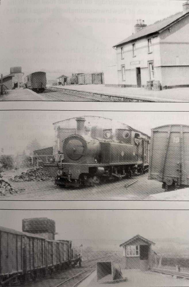
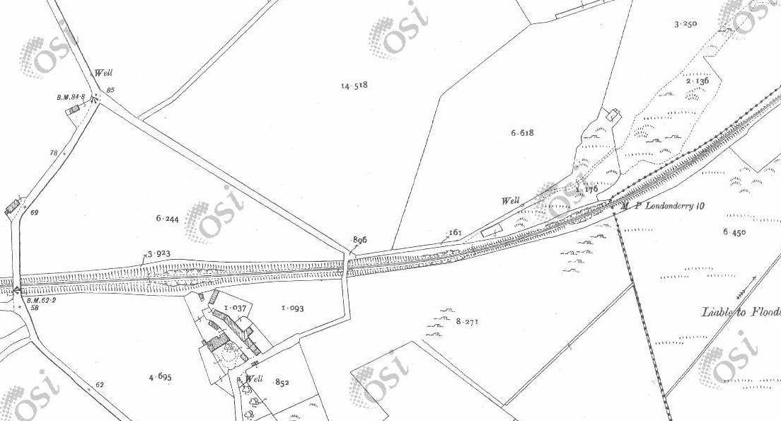
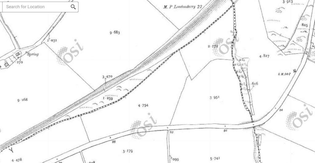
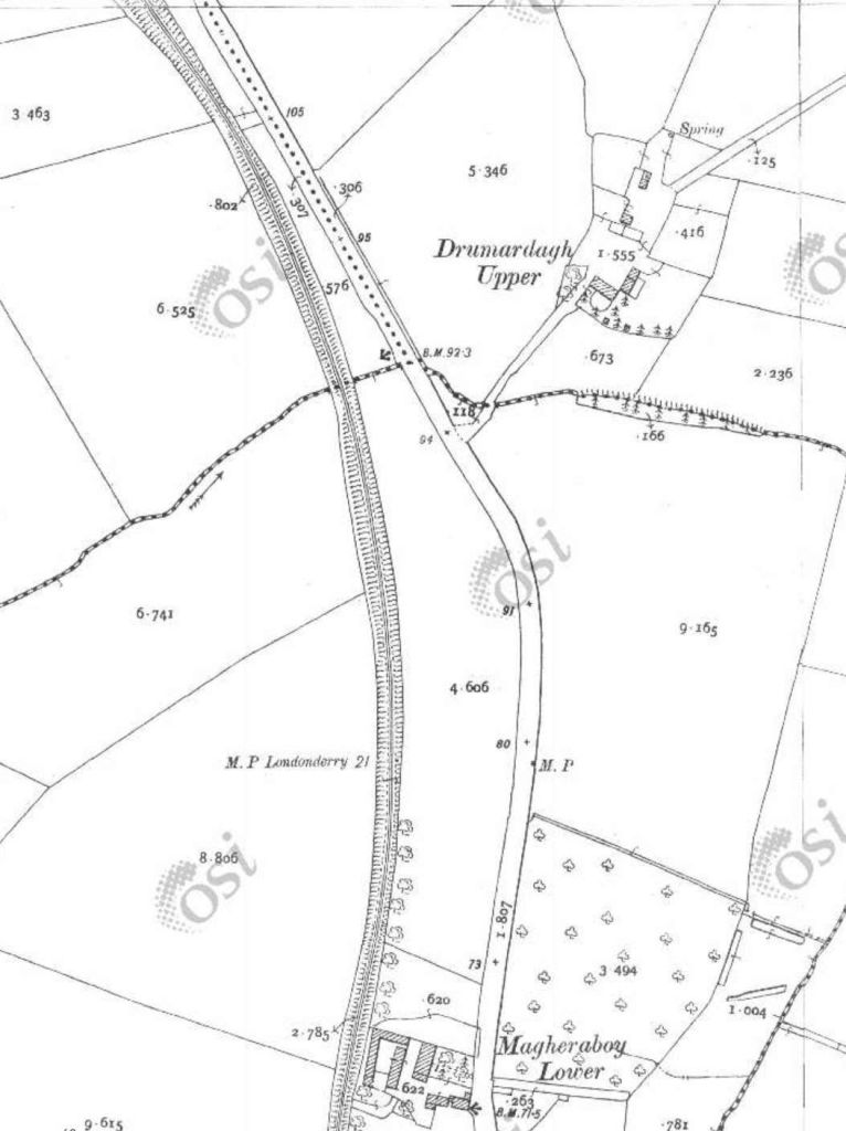
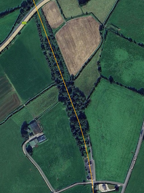
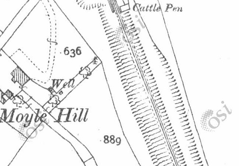
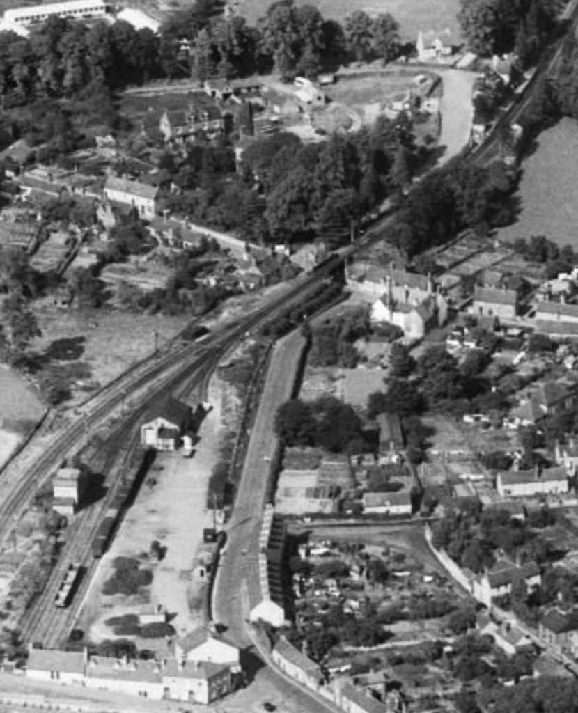
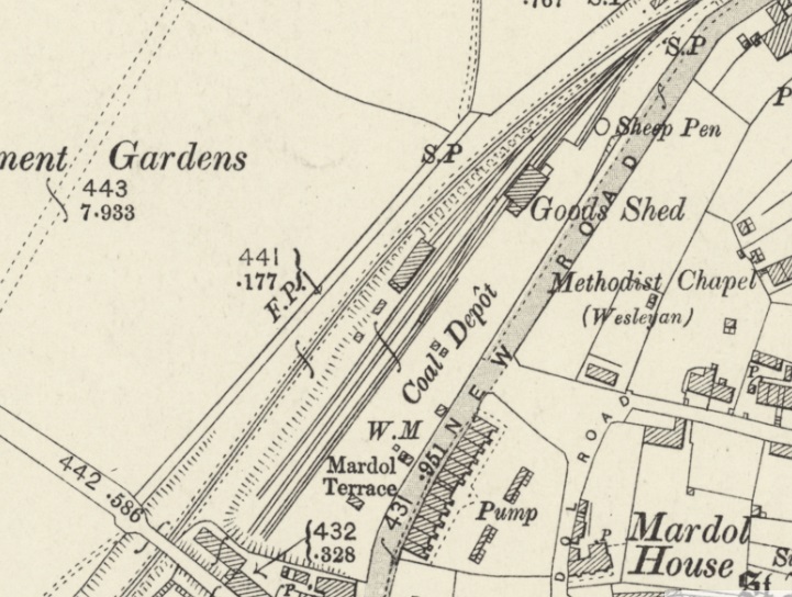
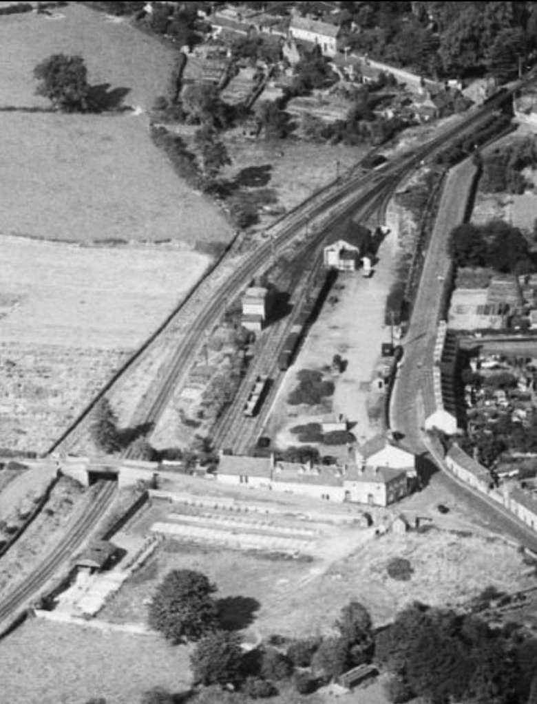
Four extracts from the OSi 25″ survey take us as far as Mason Lodge and the bridge over the line at that location. [15]
The length of the line covered by the four map extracts above as it is shown on railmaponl;ine.com’s satellite imagery. [4]
An enlarged extract from railmaponline.com’s satellite imagery focussed on the location of the bridge over the line adjacent to Mason Lodge. [4]
Looking West across the old bridge over the Lough Swilly Railway adjacent to Mason Lodge. This 21st century image shows the bridge parapets still in place. [Google Streetview, July 2021]
Looking South along the old railway the cutting is heavily overgrown in the 21st century. [Google Streetview, July 2021]
Looking North over the bridge parapet in 2021a private property straddles the old formation with the line running close to the hedge in the foreground and through the out-building ahead. {Google Streetview, July 2021]
From a point a little further to the North on the minor road which ran parallel to the old railway, it is possible to make out the stone arch which carried the road over the line. It is masked by the landscaping of the private garden. [Google Streetview, July 2021]
The line continued Northward in cutting. [15]
As this next extract from the 25″ OSi survey shows, where the cutting came to an end and before the line ran North onto embankment there was a further road crossing, this time at level. [15]
This extract from railmaponline.com’s satellite imagery covers the same length of the old railway as the two map extracts immediately above. The bridge close to Mason Lodge appears at the southern edge of the extract, the level crossing noted above appears at the top of this image. [4]
This photograph shows the view looking West across the line of the old railway at the location of the lvel-crossing. [Google Streetview, March 2011]
Looking South along the line of the Lough Swilly Railway from the levle-crossing noted above, the formation continues to be defined by boundary hedges although, in the 21st century, it is in private hands. [Google Streetview, March 2011]
Looking North from the location of the level crossing. The approximate route of the old railway is shown by the orange line. [Google Streetview, March 2011]
This next extract shows that the line North of the level crossing was on a relatively significant embankment. [15]
Continuing to the North, this next extract from the 25″ OSi survey shows a significant viaduct which carried the line over a stream. [15]
The line then crossed a more significant road by means of another bridge. This road was to become the N13 linking Letterkenny to Derry. [15]
The location of the level-crossing appears at the bottom of this next extract from railmaponline’s satellite imagery, the N13 at the top and the viaduct location just above the centre of the image. [4]
Looking Northeast along the N13 through the location of the bridge which carried the Lough Swilly Railway over the road. [Google Streetview, November 2022]
Looking South from the N13 the rail embankment has been removed for some distance from the modern road, but the embankment can be seen in the distance. Railway land at this location was wide enought o accommodate the full width of the embankment and remains delineated by the modern hedges seen in this image. [Google Streetview, November 2022]
Looking Northwest from the N13, the embankment has not been removed. The stonework of the bridge abutment and the springing at the base of the arch which spanned the old road before its widening can clearly be seen. [Google Streetview, November 2022]
The two extracts from the 25″ )Si survey show the southern approach to the station at Newtowncunningham. [15]
Newtowncunnigham Railway Station as shown on the 25″ OSi survey. The station was sited in the area known as Moyle. [15]
The site of Newtowncunningham Railway Station as shown on railmaponline.com’s satellite imagery. The bridge at the North end of the station has been removed and the road realigned. The Station House and the Water Tower remain. The Station House in private hands. [4]

(c) National Inventory of Architectural Heritage (@niah_ireland [Instagram], @NIAH_Ireland [Twitter])

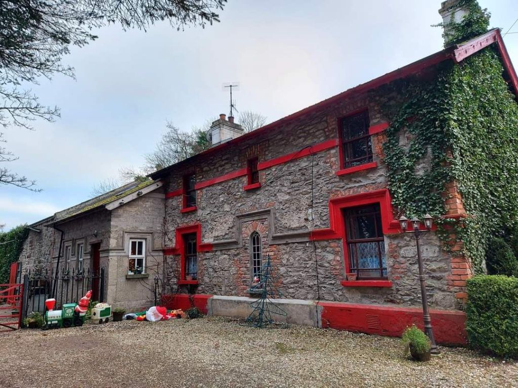
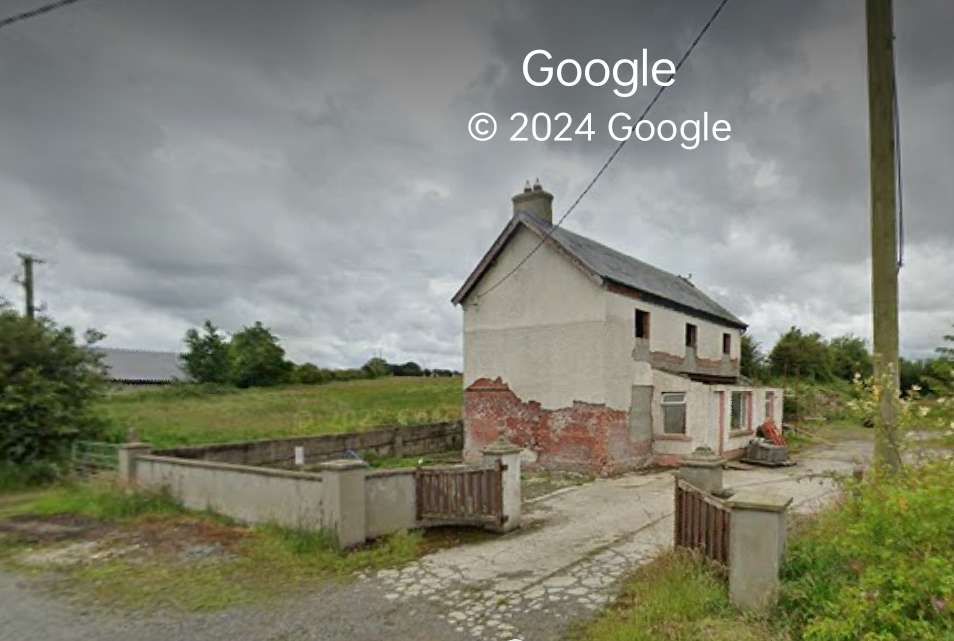
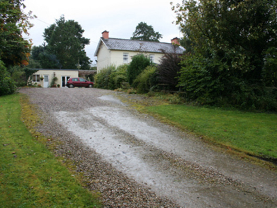
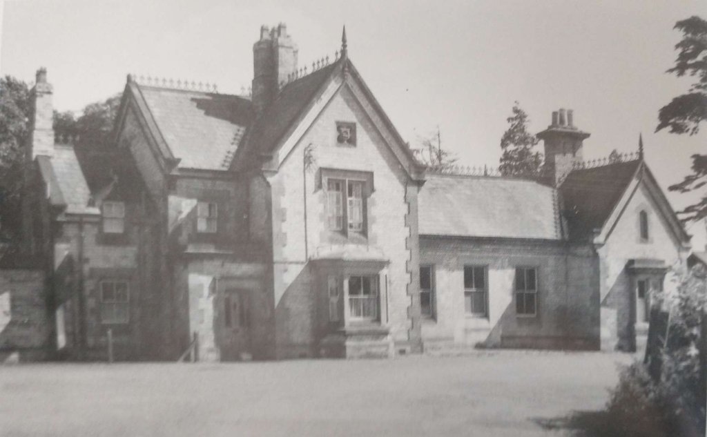
Two views of Newtowncunninham Railway Station House, now in private ownership, (c) National Inventory of Architectural Heritage (@niah_ireland [Instagram], @NIAH_Ireland [Twitter]). [22]

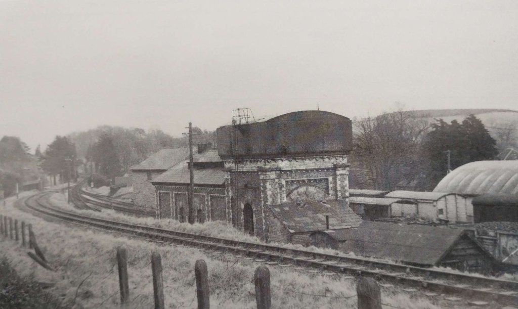
Newtowncunningham Station Water Tower. The National Inventory of Architectural heritage describes this as a “freestanding single-bay two-storey former railway water tower associated with Newtowncunningham Railway Station, built c. 1883, having rendered platform over surmounted by timber-clad metal water tank.” (c) National Inventory of Architectural Heritage (@niah_ireland [Instagram], @NIAH_Ireland [Twitter]). [22]

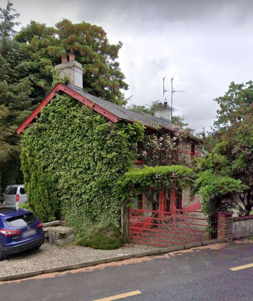
The Station House seen from the road. [My photograph, 9th May 2024]

We complete this article here at Newtowncunningham Railway Station. The next article in this series will look at the line from Newtowncunningham to Derry.

References

  1. https://en.m.wikipedia.org/wiki/Londonderry_and_Lough_Swilly_Railway, a cessed on 30th April 2024.
  2. S. Maxwell Hajducki; A Railway Atlas of Ireland; David & Charles, Newton Abbot, 1974.
  3. https://osi.maps.arcgis.com/apps/webappviewer/index.html?id=bc56a1cf08844a2aa2609aa92e89497e, accessed on 30th April 2024.
  4. https://railmaponline.com/UKIEMap.php, accessed on 1st May 2024.
  5. https://www.ebay.co.uk/itm/293669517301?mkcid=16&mkevt=1&mkrid=711-127632-2357-0&ssspo=vFhrxofnRnO&sssrc=4429486&ssuid=afQhrar7TGK&var=&widget_ver=artemis&media=COPY, accessed on 13th July 2023.
  6. https://www.letterkennyhistory.com/the-railways, accessed on 13th July 2023.
  7. https://m.facebook.com/groups/788818974978955/permalink/1011585592702291, accessed on 13th July 2023.
  8. https://www.flickr.com/photos/29903115@N06/48627305973, accessed on 3rd May 2024.
  9. https://www.facebook.com/share/p/wdwkAfVanbCPbvmT, accessed on 3rd May 2024.
  10. https://www.facebook.com/share/AEut2yYnGpVF5Bdu, accessed on 3rd May 2024.
  11. https://www.facebook.com/share/LY7arTwvoZJ3iVTs, accessed on 3rd May 2024.
  12. https://www.facebook.com/share/p/qUSZXS8nL2jjKiYG, accessed on 4th May 2024.
  13. http://geohive.maps.arcgis.com/apps/we2bappviewer/index.html?id=9def898f708b47f19a8d8b7088a100c4, accessed on 27th and 28th October 2020.
  14. https://catalogue.nli.ie/Record/vtls000332873, accessed on 5th May 2024.
  15. https://osi.maps.arcgis.com/apps/webappviewer/index.html?id=bc56a1cf08844a2aa2609aa92e89497e, accessed on 5th May 2024.
  16. https://www.facebook.com/share/p/8ZMXsiwAdUZFuj7X, accessed on 5th May 2024.
  17. In 2020, Kerry Doherty of Ballindrait very kindly sent me a series of pictures of the Co. Donegal Railways Strabane and Letterkenny Railway route. Each of these, in this article, bears the reference number [17].
  18. Dave Bell and Steve Flanders; The Londonderry and Lough Swilly Railway: A Visitor’s Guide; County Donegal Railway Restoration Society.
  19. http://donegalgenealogy.com/1901pluck.htm, accessed on 8th May 2024.
  20. https://www.donegaldaily.com/2024/03/19/plans-for-reinstatement-of-old-east-donegal-railway-line, accessed on 9th May 2024.
  21. https://www.facebook.com/share/p/WPFKVTW43vPdgCJY, accessed on 9th May 2024.
  22. https://www.buildingsofireland.ie/buildings-search/?query=&location_type=building&county=DG&town=Newtowncunningham&townland=&group=&type=&date_from=&date_to=, accessed on 16th May 2024.
  23. https://www.facebook.com/groups/788818974978955/permalink/1209152166278965/?app=fbl, accessed on 2nd June 2024.

The Wenlock Branch from Much Wenlock to Presthope

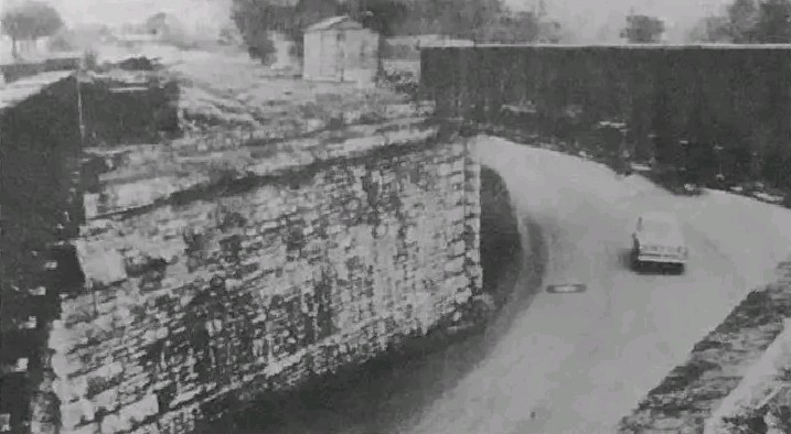
The featured image shows Presthope Station with the 18.00 hrs Craven Arms – Much Wenlock – Wellington train is leaving on 21st April 1951, heading for Much Wenlock. [30]

This article follows on from four other articles which covered the Wellington to Severn Junction Railway and this line from Buildwas to Much Wenlock. The first three articles can be found on these links:

https://rogerfarnworth.com/2022/07/07/the-railways-of-telford-the-wellington-to-severn-junction-railway-wsjr-part-1-wellington-to-horsehay

https://rogerfarnworth.com/2022/07/12/the-railways-of-telford-the-wellington-to-severn-junction-railway-wsjr-part-2-horsehay-to-lightmoor-junction

https://rogerfarnworth.com/2022/07/18/the-railways-of-telford-the-wellington-to-severn-junction-railway-wsjr-part-3-lightmoor-junction-to-buildwas

The most recent article covers this line between Buildwas and Much Wenlock and can be found here:

The Railways of East Shropshire (and Telford) – the Much Wenlock and Severn Junction Railway, Buildwas to Much Wenlock.

Much Wenlock to Presthope and on to Craven Arms

From the commencement of the building of the line between Buildwas and Much Wenlock, the directors hoped that the line could be extended to Craven Arms via Presthope on Wenlock Edge (linking with the limestone quarries/works at that location).

The directors of the Wellington & Severn Junction Railway were, however, fully occupied with the line from Wellington to Buildwas. Another company was set up to build the ‘Wenlock & Craven Arms and Coalbrookdale Extension Railway‘. The bill went through the parliamentary process unopposed and authorised the ‘Wenlock Railway Company‘ to construct the line. Work started on 23rd October 1861.

By 5th December 1864, the line was open from Much Wenlock to Presthope. At this time, because it was a freight-only line, the Board of Trade saw no need for an inspection of the line. It had already been agreed at a meeting held on 4th December 1863 not to proceed with the line from Presthope to Craven Arms for the time being. It was to be three years after the line reached Presthope before the connection to the Shrewsbury & Hereford Railway close to Craven Arms was completed. It was finally opened on 16th December 1867.

Much Wenlock to Presthope

This article focusses on the length of the line which was completed in December 1864 – Much Wenlock to Presthope. Another article will follow the line to the West of Presthope.

We start at Much Wenlock Railway Station.

The forecourt of Much Wenlock station in the early 1960s. The building was designed by Joseph Fogerty © R.S. Carpenter. [1: p100]
The Wenlock Branch ran across the Northwest side of the town. The railway station was due North of the town centre and was accessed from a loop off  Sheinton Road. Station Road leading up to the Station from close to the railway bridge. [4]
The 25″ Ordnance Survey of 1901 shows Much Wenlock Station with its platform on the Northwest side of the running line and a passing-loop to the Southeast. Partially off the left of the map extract is the town brewery. [5]

Much Wenlock Railway Station had a single platform adjacent to the main running line. A passing loop was provided opposing the platform, and beyond it there was a rockery garden, “large limestone boulders [were] interspersed with shrubs and alpine plants flanked by a row of rhododendron bushes. In the centre of the rockery was a fountain.” [1: p97]

Much Wenlock Railway Station in the very early 20th century. The passing-loop and the adjacent rockery garden are on the right of the image. The photograph looks Northeast through the station. [7]
The photographer is standing on the running line a few steps further to the Southwest. This photo was taken on 12th July 1969 by David Hillas and is used here under a Creative Commons Licence (CC BY-SA 2.0 DEED). [8]
The length of the station site as shown on Railmaponline.com. The running line is shown in green with a single line indicating the location of the Goods Yard. [12]
This is a first extract, in this article, from the pre-contract plans of the Much Wenlock line which are held in the Shropshire Archives in Shrewsbury. It shows the full length of the station facilities (passenger and goods) at Much Wenlock. It shows approximately the same length as the RailMapOnline image above. The Station building was on the West side of the line and North of the bridge which carried the line over what became the A4169. The goods yard was South of the bridge on the East side of the line. … As we have noted in the article about the line between Buildwas and Much Wenlock, these precontract plans were orientated in respect to the North point so as to get the greatest possible length of the proposed railway onto each sheet,, © Shropshire Archives Ref. No. 6008/26 copyright reserved, used by kind permission. [9][My photograph of the plan, 5th August 2022]

Trains leaving for Craven Arms crossed Sheinton Road/Street Bridge and passed the goods shed and yard on the left and then the engine shed. When the line terminated at Much Wenlock, the goods facilities used until the final closure of the line were the temporary railway station.

A view Northwest along Sheinton Street taken outside number 19 Sheinton St. It is included here for the view of the railway bridge over the road and was taken in the first half of the 1960s. This image was shared on the Much Wenlock Memories Facebook Group by Lynne Steele on 10th April 2021. [10]
A view Southeast along Sheinton Street showing one of the carnival walks in Much Wenlock probably in the mid-60s. It is included here for the view of the railway bridge which span the road. This image was shared on the Much Wenlock Memories Facebook Group by Colin Onions on 2nd February 2015. [11]
Looking Northeast along the line of the old railway towards the passenger Station from the approximate location of the second abutment of the railway bridge. Just the one abutment remains, the other having been removed to facilitate a road realignment. The road from Buildwas (Sheinton Street) becomes New Road at this point with Sheinton Street heading away to the right of the image. [Google Streetview, August 2023]
This is the view when the camera is turned through 180°. The approximate line of the old railway is marked, in this case, by the red line. New Road and the route of the railway diverged and provided space for what became the Goods Yard and for a coal depot which, in the early 21st century is occupied by a builders merchant (Travis Perkins). [Google Streetview, August 2023]
Looking Southwest along Southfield Road. The hedge line on the left of this image is approximately on the line of the old railway. [Google Streetview, 2009]
Much Wenlock Goods Yard. Centre-left are the cattle pens and grain store. The grain store is attached to the good shed. On the right is the engine shed with the water tank. The water tank was fed by a reservoir further Southwest along the line – about halfway to the next halt, Westwood Halt, © Shropshire Museum Service [1: p101]
The goods yard, viewed from the Southwest the line in the foreground is the main running line which claims along the flank of Wenlock Edge. The good yard was, for a short time, the terminus of the line after the partial opening on 1st February 1862 © Pat Garland. [1: p101]

Trains began the climb towards Wenlock Edge. The pictures above show the climb had already begun alongside the goods yard. Neither the goods shed nor the engine shed remain in the 21st century.

This aerial view is taken looking North across Much Wenlock (EAW046197 © Heritage England). The station goods yard is prominent approximately at the centre of the image, with Sheinton Street and the railway bridge separating the yard from the passenger facilities in the top-right of the image, and the bridge carrying Bridge Road over the line at the bottom-left. [3]
This extract from an aerial image (EAW046196 © Heritage England) shows the full length of the station facilities at Much Wenlock. The passenger Station building is visible top-right, the goods yard and engine stabling facilities, bottom-left. Between the two Sheinton Street passed under the railway. [2]
New Road ran along the Southeast side of the Goods Yard. The Goods Shed and the Engine Shared appear on this additional extract from the 25″ Ordnance Survey of 1901. A coal depot sat between the road and the sidings in the yard. The road bridge is at the top-right of the map extract. Bottom-left as the running line leaves the map extract it passes under Bridge Road. The bridge here was simply-supported cast iron beams on masonry abutments. [6]
Another extract from the same aerial image centres on the goods yard with the running line to the left and passing under the cast iron bridge carrying Bridge Road. New Road runs down the right side of the picture. [2]
A closer view of the cast iron bridge carrying Bridge Road over the railway. This is an enlargement from the same aerial image. [2]
Looking Southwest from Southfield Road. The main structure of the bridge is still evident in the early 21st century. [Google Streetview, 2009]
Looking Southeast at the other elevation of the cast-iron bridge. The partial infill is much closer to the soffit on this side of the bridge. [Google Streetview, 2009]
Looking North over the bridge parapet from Bridge Road. The old railway ran parallel to Southfield Road in the grass area at the centre of the image. [Google Streetview, 2009]
Looking West over the bridge parapet from Bridge Road. The old railway ran parallel to Southfield Road in the grass area at the centre of the image. [Google Streetview, 2009]
Southwest of Bridge Road, Southfield Road ran parallel to the old railway as it climbed along the Northwest side of the town. Victoria Road can be seen at the bottom of this image. [2]
The line continued in a southwesterly direction. Southfield Road ran alongside it. Victoria Road can be seen at the bottom of this image. It passed under the railway a short distance beyond the edge of the aerial image which is also the left edge of this extract. [2]
The next length of the railway appears on this extract from the 25″Ordnance Survey of 1901. Bridge Road bridge is top-right and the road to Shrewsbury runs East-West across the bottom half of the image. In 1901, this was known as ‘The Causeway’. It became the A458, Victoria Road. [14]
Approximately the same length of the railway as shown in the map extract above, but now on the satellite imagery from ralmaponline.com. The primrose yellow line shows the route of the A458, Victoria Road. [12]
Looking back Northeast towards Much Wenlock Railway Station from High Causeway. Southfield Road is on the left. The housing estate has been built over the Goods Yard. [Google Streetview, 2009]
Looking Southwest along the line of the old railway. Southfield Road is on the right. The railway
This and the next three OS map extracts cover the first part of the climb out of Much Wenlock the bridge over the A458 is at the top-right of this map extract. [15]
The bridge over what is now the A458 in the midst of its demolition at the end of the 1960s. This image looks Northeast along the railway formation towards Much Wenlock Station and Goods Yard. It was shared on the Much Wenlock History Facebook Group by Linda West on 2nd April 2020. [18]
The remaining abutment of the bridge which carried the Wenlock Branch over Victoria Road (A458), © Richard Webb and licenced for use under a Creative Commons Licence (CC BY-SA 2.0 DEED). [20]
These two images are extracts from the pre-contract drawings of the Wenlock Branch. The girder bridge which spanned the road at this location was almost exactly 4 miles from Buildwas Junction and fell, in these drawings at the edges of two drawings. Both are reproduced here because they have something to contribute to local information. Perhaps of greatest significance for the railway was the fact that the bridge was constructed allowing for the possibility of providing an additional line, if traffic volumes made it worthwhile. These pre-contract plans were orientated in respect to the North point so as to get the greatest possible length of the proposed railway onto each sheet, © Shropshire Archives Ref. No. 6008/26 copyright reserved, used by kind permission. [9][My photograph of the plan, 5th August 2022]
The next length of the line continued in a Southwesterly direction. After passing under an accommodation bridge, it began to turn to the South. [13]
The reservoir which appears on this OS map extract on the East side of the line was used to provide water for the column at Much Wenlock Station. [1: p97] [16]
The reservoir which supplied the water column at Much Wenlock Station was around half a mile beyond the bridge over the A458. These pre-contract plans were orientated in respect to the North point so as to get the greatest possible length of the proposed railway onto each sheet, © Shropshire Archives Ref. No. 6008/26 copyright reserved, used by kind permission. [9][My photograph of the plan, 5th August 2022]
The reservoir as it appears in the 21st century. It has been extended and has varying levels over time suggesting that it may be used as a balancing pond to moderate the flow on the stream which follows the old railway line and which appears to now follow the old railways route in an improved channel to the Southwest of the reservoir. The track shown in this extract from Google Maps continues a short distance to the South before crossing both the stream and the old railway route.A footpath continues alongside the old line to the East. [Google Maps, 13th January 2024]
Curving round again towards the Southwest, the line passed Grange Cottages. [17]
This railmaponline.com satellite image covers the same length of line as the last four OS Map extracts. [12]
The first road overbridge to the West of Much Wenlock. This view looks Southwest along the line of the old railway. The bridge carries a track which leaves the B4371, Stretton Road in a southerly direction and provides access in the 21st century to the Cuan Wildlife Centre. [My photograph, 12th January 2024]
The view Northeast from the overbridge. The old railway route is now followed by a line of conifers on its North side. [My photograph, 12th January 2024]
The view Southwest over the parapet of the same bridge. The warehouse is built over the old railway line. [My photograph, 12th January 2024]
Looking Northeast again for a point beyond the warehouse in the last picture. The warehouse sits over the line of the old railway which continued Southwest to the left of the green palisade fencing on the left side of this image. The track in the centre of the image runs parallel to and to the South of the line of the railway. [My photograph, 12th January 2024]
Looking back Northeast along the route of the old railway. The gate towards the back of this photo straddles the centre-line. The gardens associated with Grange Cottages now extend across the line of the railway. [My photograph, 12th January 2024]
Looking Southwest along the line of the old railway from the fence line of Grange Cottages garden. The gate across the line of the old railway indicates that the next length is also in private hands. A public footpath runs to the left of the tree line
This next extract from the OS mapping of 1901 takes the line as far as the location of Westwood Halt which was at the location marked by the blue flag above. [21]
A closer view of the location of the Halt in 1925. The 25″ OS mapping indicates that the Halt was not built by 1925. [22]
The length of the old railway between Grange Cottages and Westwood Halt as shown on the satellite imagery from railmaponline.com. [12]

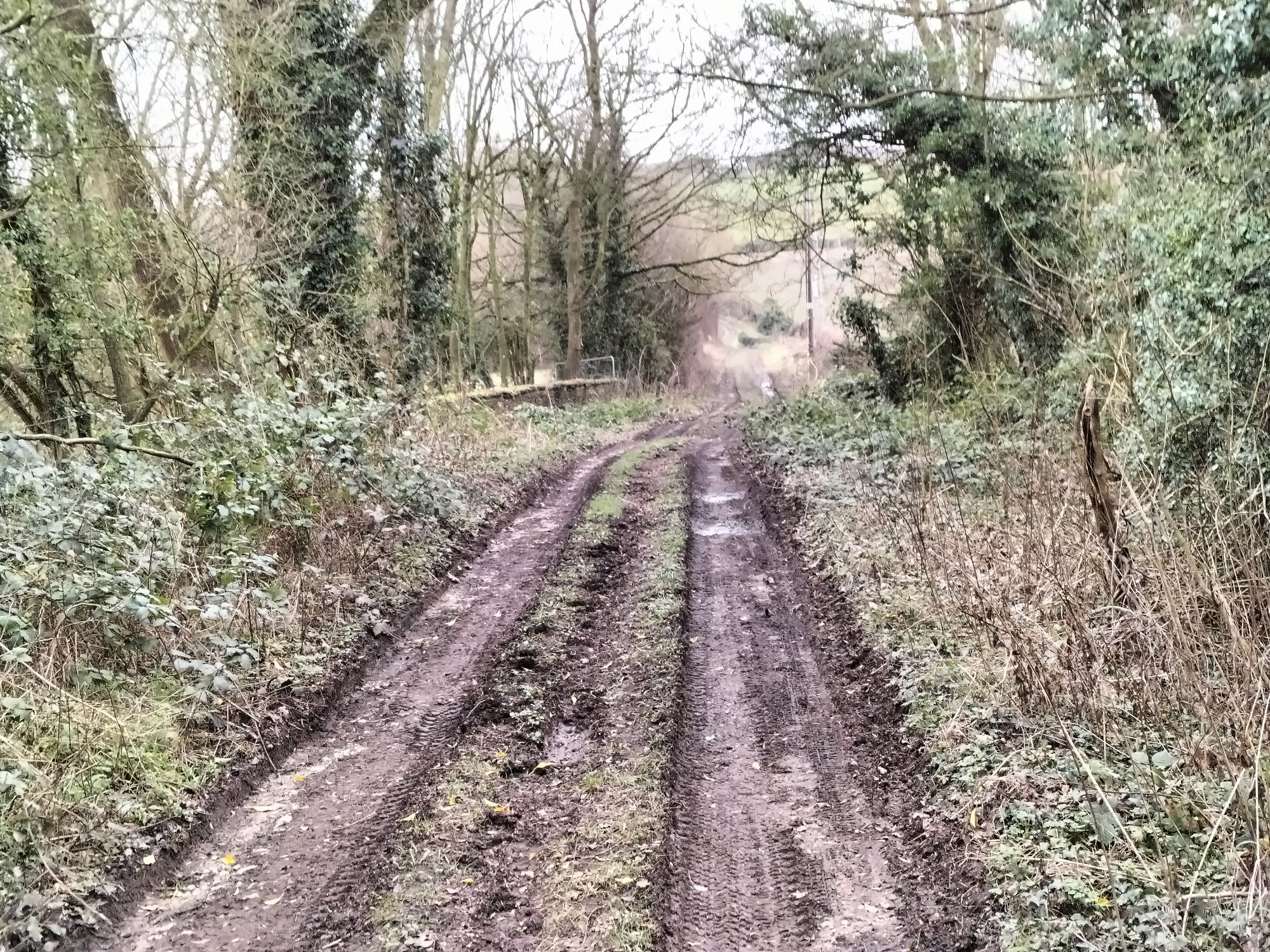
That length is in private hands with a significant length in use as a paddock for horses and a small holding.

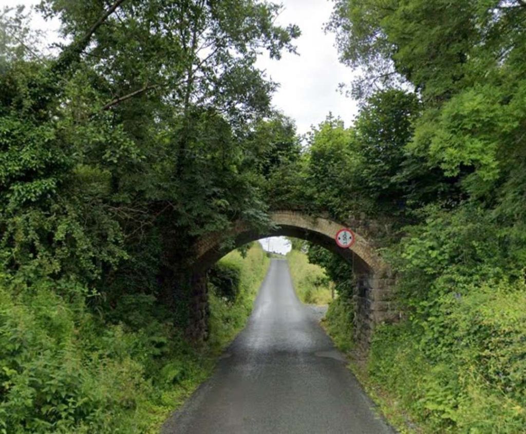
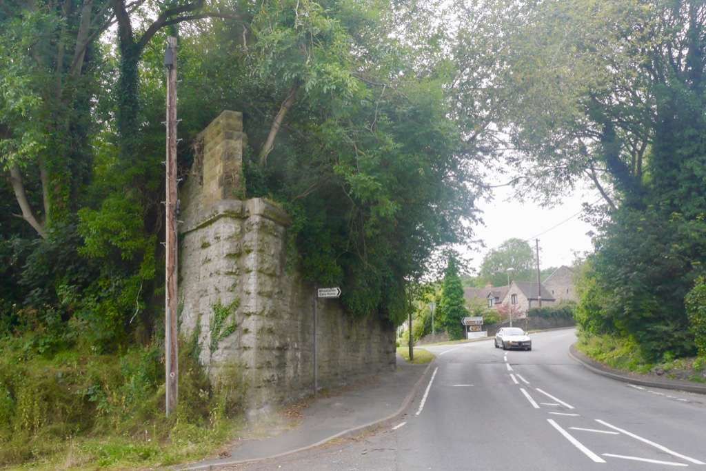
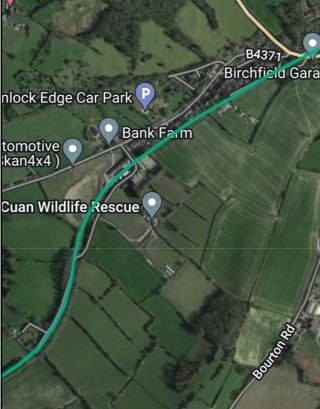
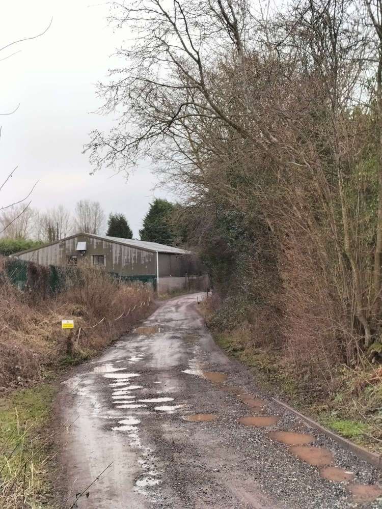
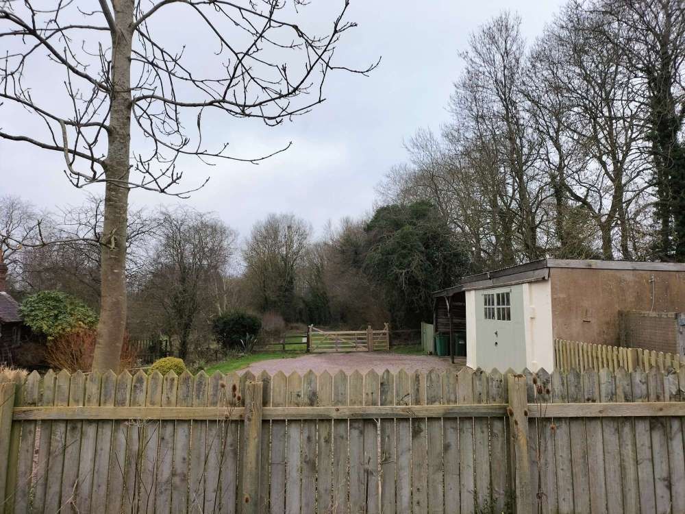
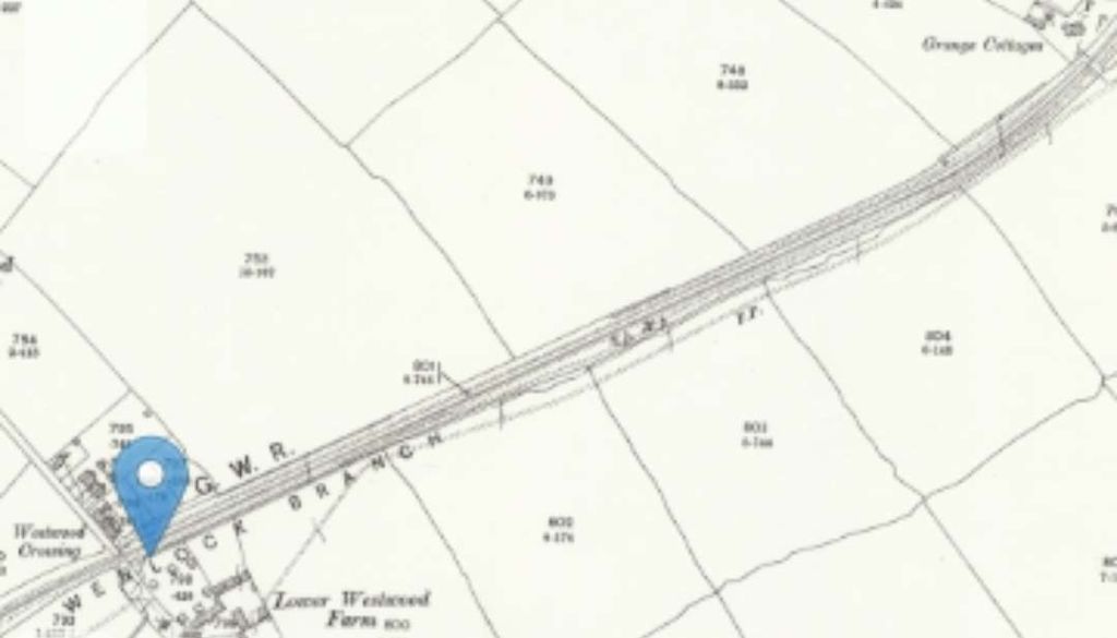
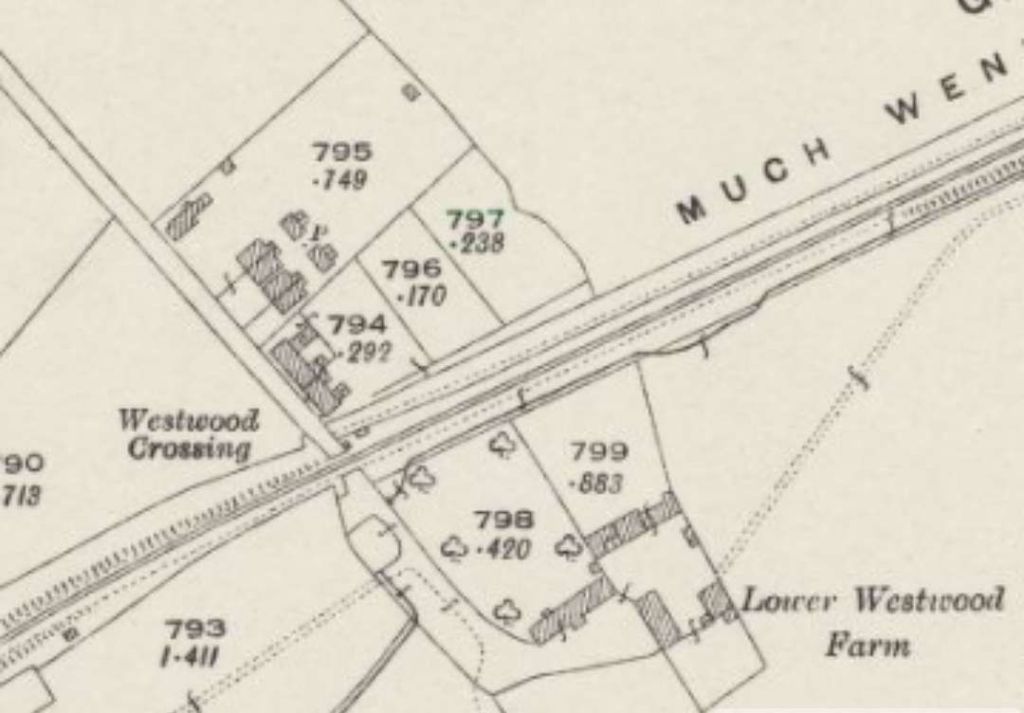
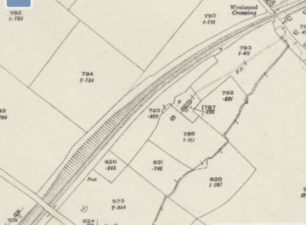
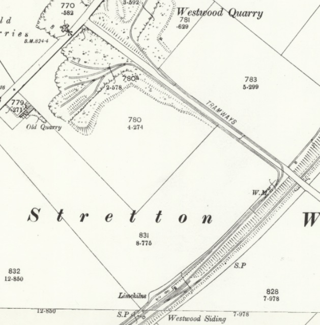
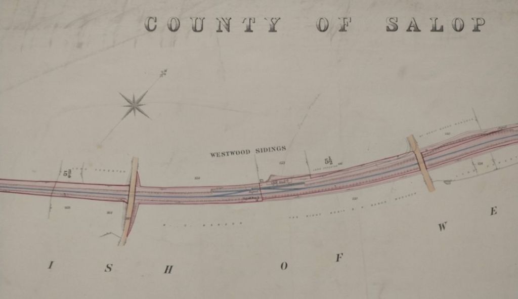
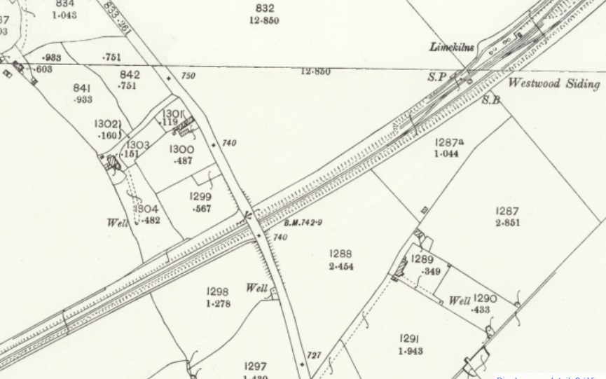
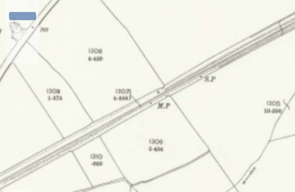
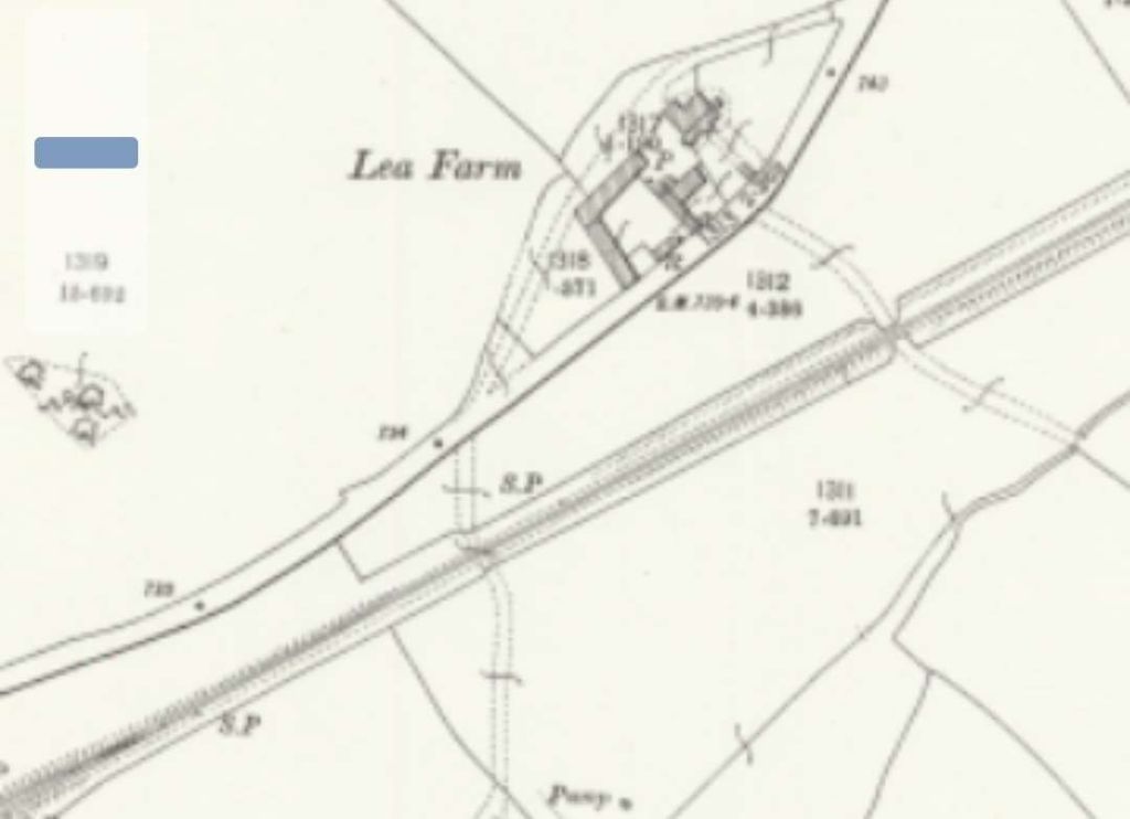
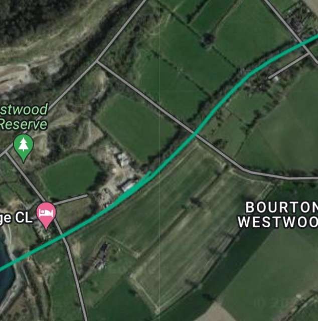
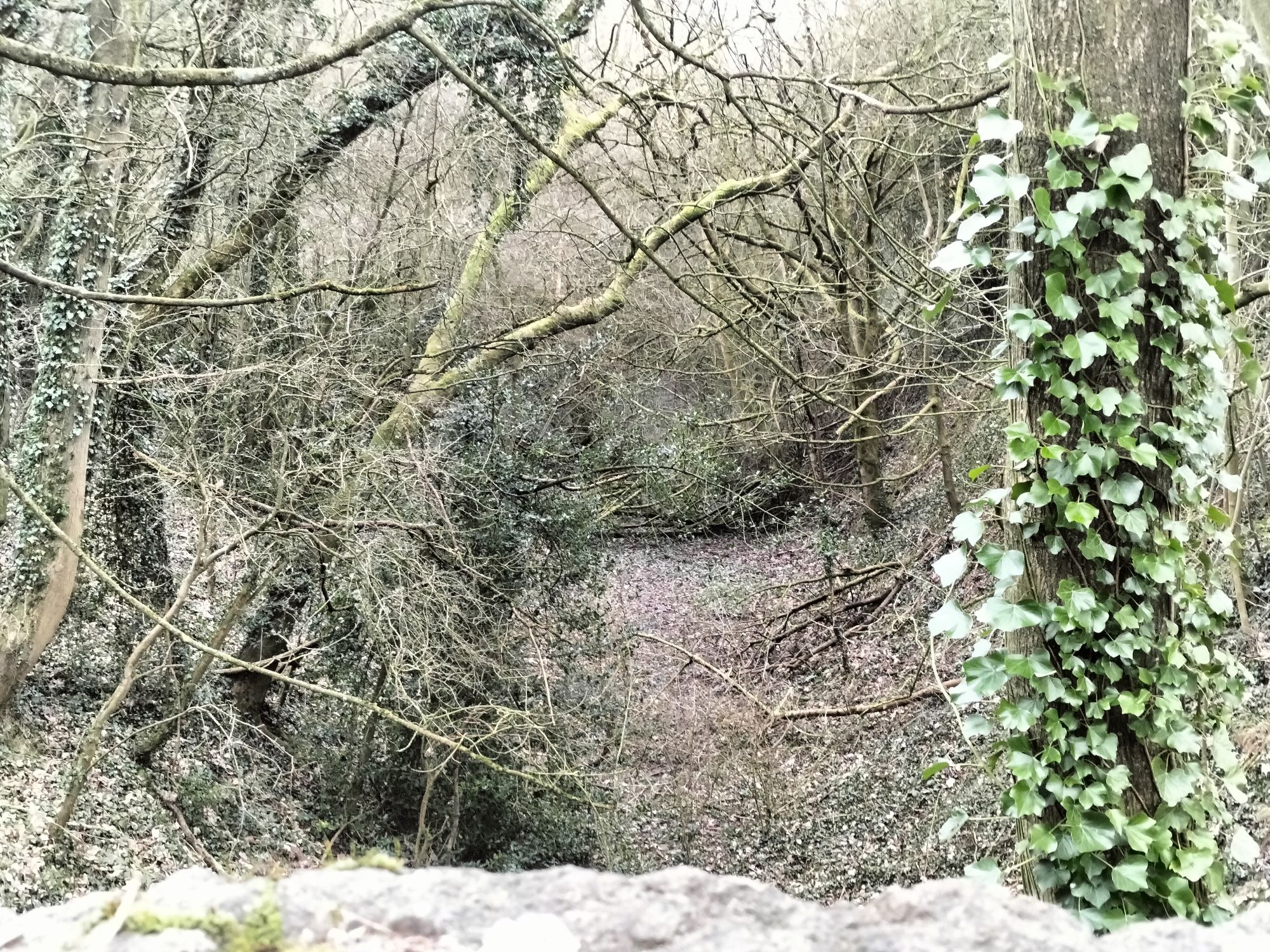
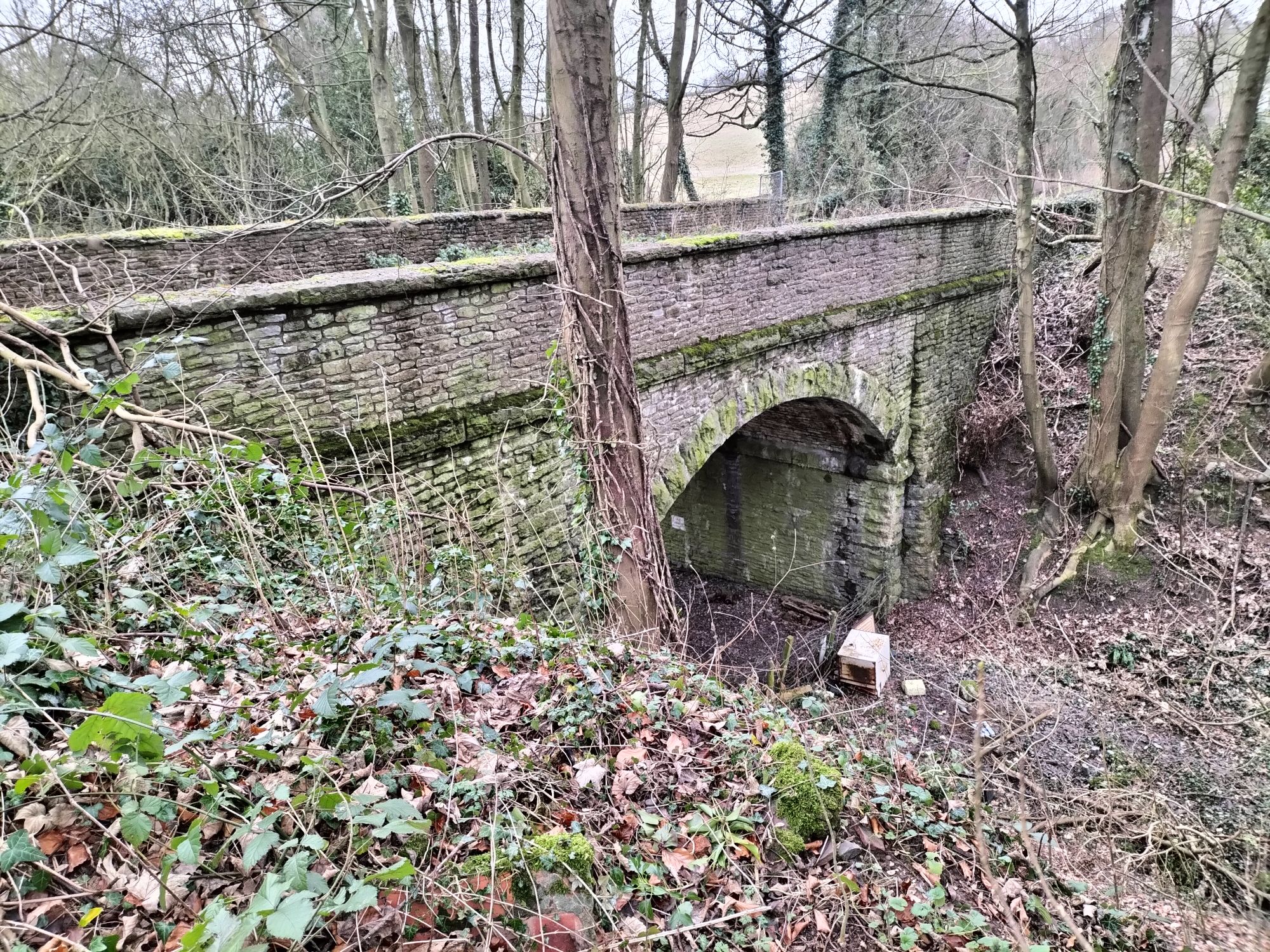
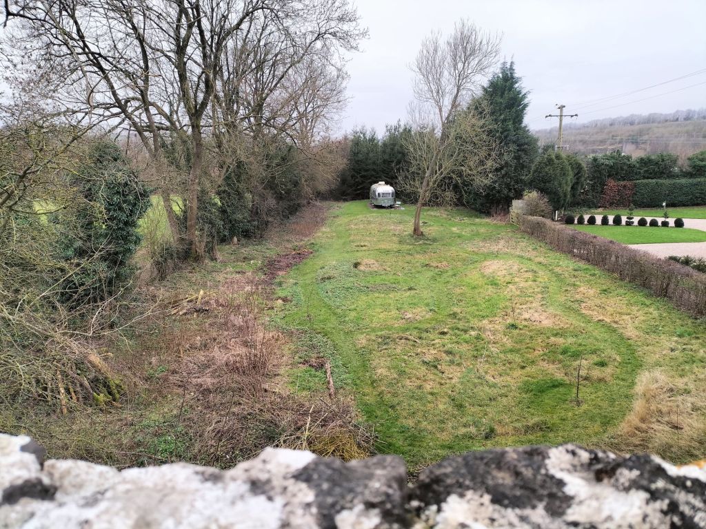
Westwood Halt in around 1960 – seen from the East. The single platform sat on the North side of the line immediately to the East of Westwood Crossing. It was not until 7th December 1935 that the Halt opened. It closed to passenger traffic on 31st December 1951. This picture was shared on the Much Wenlock Memories Facebook Group by Judith Goodman on 8th December 2020. The photographer is not known and the image is used under a Creative Commons Licence (CC BY-SA 4.0). [19]
Google Maps image of the site of Westwood Halt. [Google Maps, 12th January 2024]
Westwood Crossing seen from the North. The red line marks the approximate centre-line of the old railway. The Halt would have been off to the left of this image. [Google Streetview, 2009]
Looking Northwest from Westwood Crossing towards the B4371. [My photograph, 12th January 2024]
Looking Southeast from the location of Westwood Crossing. It is not possible to follow the route of the old railway to the West of this location as it is in private hands. To continue following the route requires a diversion along the footpath ahead, across one field to join another track and then heading back Northwest towards the olod line. [My photograph, 12th January 2024]
The line leaving Westwood Crossing and heading towards Presthope. [My photograph, 12th January 2024]
Westwood Crossing to the next overbridge, as shown on the 25″ Ordnance Survey of 1901. [22]
Within a couple of hundred yards, trains passed Westwood Sidings. The sidings served Westwood Quarry. There were ground frames controlling access at each end of the siding. [23]

When the Wenlock Branch opened “limestone was being extracted [at Westwood Quarry] for use in the Madeley Wood Company’s furnaces. Horse-drawn tramways ran from the quarry on to a loading ramp above the sidings.” [1: p97]

The immediate vicinity of the line close to Westwood Quarry. A tramway track ran from the quarry to the old railway. A sharp 90° turn took horse-drawn trams alongside the old railway to a wharf/loading ramp alongside the siding, © Shropshire Archives Ref. No. 6008/26 copyright reserved, used by kind permission. [9][My photograph of the plan, 5th August 2022]
Westwood Sidings as they appear on the pre-contract drawings for the construction of the Wenlock Branch, the tramway serving the Quarry ran alongside the Wenlock Branch from East to West, © Shropshire Archives Ref. No. 6008/26 copyright reserved, used by kind permission. [9][My photograph of the plan, 5th August 2022]
This extract from the 1901 25″ Ordnance Survey shows the length of the old railway immediately to the West of Westwood Sidings. [25]
And a little further to the Southwest. [26]
The 25″Ordnance Survey of 1901 again. Close to Lea Farm the B4371 and the Wenlock Branch run close to each other. [27]
This extract from the pre-contract drawings covers the same length of the Wenlock Branch as the three OS map extracts above, © Shropshire Archives Ref. No. 6008/26 copyright reserved, used by kind permission. [9][My photograph of the plan, 5th August 2022]
The immediate vicinity of the old Westwood Sidings as shown on modern Ordnance Survey mapping (OS Explorer No. 217). The route of the old railway can easily be picked out entering top-right and running across the North side of Lower Farm, a public footpath follows the line as far as the location of Westwood Crossing. The route of the old line is then crossed by an unmetalled track (which, on the North side of the line, was once a horse-drawn tramway) before it encounters the bridge illustrated below which, in the 21st century, is crossed by a metalled track. Westwood Sidings sat between these two tracks. Continuing Southwest, the route of the old line encounters quarry workings which postdated the closure of the railway and which in the 21st century are now flooded. [24]
The length of the old line from Westwood Crossing to the Eastern edge of the flooded workings of Lea Quarry which straddle the old rail route. [12]
Looking back towards Westwood Crossing from the first overbridge to the West. [My photograph 12th January 2024]
The bridge viewed from the top of the cutting to the West of the bridge. [My photograph, 12th January 2024]
The view from the Southeast along the track over the bridge. Westwood Sidings were along the old railway to the left. A tramroad climbed the track in front of the camera towards Wenlock Edge and the B4371. Thetramway served Westwood Quarries which were between the railway and the B4371. [My photograph, 12th January 2024]
The old railway ran ahead towards Presthope in cutting towards the next overbridge. [My photograph, 12th January 2023]
The next accommodation bridge which spanned the line was just a little further to the West, beyond of the Westwood Sidings. This photograph looks South along the road over the bridge. [Google Streetview, August 2021]
The same bridge which This photograph looks South along the road over the bridge. [Google Streetview, August 2021]
Looking back towards Westwood Halt from the next overbridge. Heavy winter rain means that the cutting floor is flooded. Westwood Sidings were between the last overbridge and this one. [My photograph, 12th January 2024]
Each of the bridges on the old line are numbered. It is probably sometime since the stenciled numbers were renewed. Is this Bridge No. 16?
The view to the Southwest from the bridge. A small caravan site occupies the formation here. Immediately beyond the conifers ahead are the flooded workings of Lea Quarry. [My photograph, 12th January 2024]
Lea Quarry was only a short distance from the location of Westwood Quarry. Lea Quarry’s flooded workings appear in full on this extract from the railmaponline.com satellite imagery. The flooded workings to the North of the B4371 sit where once Lea Farm would have been found. It is not obvious when travelling along the road that it is effect on a causeway between two lakes! Edge Renewables was founded in 2011 and is active in the part of Lea Quarry to the North side of the road.[12]
Another extract from the 25″ Ordnance Survey of 1901. This extract focuses on Presthope Station which sat just to the South of the B4371 accessed by a dedicated approach road. [28]
This next extract from the railmaponline.com satellite imagery shows Presthope Grange Campsite and Residential Park sitting over the route of the old Wenlock Branch on the site of Presthope Station. The branch from Presthope Station into what were Presthope quarries is illustrated leaving the main running line as it continues to climb toward the short tunnel close to the top of Wenlock Edge. [12]
The 18.00 hrs Craven Arms – Much Wenlock – Wellington train leaving Presthope Station on 21st April 1951, heading for Much Wenlock. This image was shared on the Telford memories Facebook Group by Metsa Vaim EdOrg on 8th October 2019. [30]
Presthope Station after the removal of the passenger facilities. This photograph was taken by J. Langford in April 1962, the signal box and presumably the station master’s house remain. This image was shared on the Much Wenlock Memories Facebook Group by Judith Goodman on 9th February 2023. [31]
A view North across Presthope Grange Residential Park which sits on the site of Presthope Railway Station. [32]

References

  1. Ken Jones; The Wenlock Branch; The Oakwood Press, Usk, Monmouthshire, 1998.
  2. https://www.britainfromabove.org.uk/image/EAW046196, accessed on 1st November 2023
  3. https://www.britainfromabove.org.uk/image/EAW046197, accessed on 1st November 2023.
  4. https://www.british-history.ac.uk/vch/salop/vol10/pp399-447, accessed on 25th December 2023.
  5. https://maps.nls.uk/geo/explore/#zoom=17.5&lat=52.59954&lon=-2.55716&layers=168&b=1, accessed on 25th December 2023.
  6. https://maps.nls.uk/geo/explore/#zoom=16.9&lat=52.59775&lon=-2.56049&layers=168&b=1, accessed on 25th December 2023.
  7. https://en.m.wikipedia.org/wiki/Much_Wenlock_railway_station, accessed on 25th December 2023.
  8. https://www.geograph.org.uk/photo/2268995, accessed on 25th December 2023.
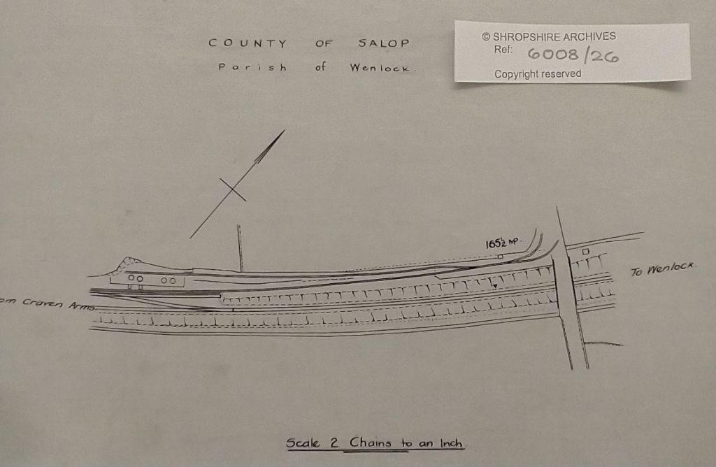
  9. The photographs of the pre-contract drawings for the line were taken by myself and show extracts from the construction plans held in the Shropshire Archive. There is a standard charge of £10 per visit for taking photographs of their records.
  10. https://www.facebook.com/photo?fbid=871714362892537&set=pcb.1583276891885898, accessed on 13th October 2023.
  11. https://en.m.wikipedia.org/wiki/File:Much_Wenlock_railway_station.jpg, accessed on 14th October 2023.
  12. https://railmaponline.com/UKIEMap.php, 14th October 2023.
  13. https://maps.nls.uk/geo/explore/#zoom=16.5&lat=52.59360&lon=-2.57210&layers=168&b=1, accessed on 27th December 2023.
  14. https://maps.nls.uk/geo/explore/#zoom=16.5&lat=52.59611&lon=-2.56444&layers=168&b=1, accessed on 27th December 2023.
  15. https://maps.nls.uk/geo/explore/#zoom=16.5&lat=52.59513&lon=-2.56857&layers=168&b=1, accessed on 27th December 2023.
  16. https://maps.nls.uk/geo/explore/#zoom=16.5&lat=52.59146&lon=-2.57500&layers=168&b=1, accessed on 27th December 2023.
  17. https://maps.nls.uk/geo/explore/#zoom=16.5&lat=52.58847&lon=-2.57795&layers=168&b=1, accessed on 27th December 2023.
  18. https://www.facebook.com/groups/1532191000361509/permalink/2624088597838405/?app=fbl, accessed on 27th December 2023.
  19. https://m.facebook.com/groups/1470137459866509/permalink/3158174324396139, accessed on 27th December 2023; and https://commons.m.wikimedia.org/wiki/File:Westwood_halt.jpg, accessed on 28th December 2023.
  20. https://www.geograph.org.uk/photo/6220870, accessed on 27th December 2023.
  21. https://maps.nls.uk/geo/explore/#zoom=15.5&lat=52.58777&lon=-2.58269&layers=168&b=1&marker=52.58420,-2.58663, accessed on 28th December 2023.
  22. https://maps.nls.uk/view/121151366, accessed on 28th December 2023.
  23. https://maps.nls.uk/geo/explore/#zoom=16.2&lat=52.58321&lon=-2.59431&layers=168&b=1, accessed on 28th December 2023.
  24. Ordnance Survey Explorer Map No. 217.
  25. https://maps.nls.uk/geo/explore/#zoom=16.4&lat=52.58031&lon=-2.59601&layers=168&b=1, accessed on 30th December 2023.
  26. https://maps.nls.uk/geo/explore/#zoom=16.4&lat=52.57873&lon=-2.60143&layers=168&b=1, accessed on 30th December 2023.
  27. https://maps.nls.uk/geo/explore/#zoom=16.4&lat=52.57772&lon=-2.60633&layers=168&b=1, accessed on 30th December 2023.
  28. https://maps.nls.uk/geo/explore/#zoom=15.9&lat=52.57594&lon=-2.61148&layers=168&b=1, accessed on 2nd January 2024.
  29. https://maps.nls.uk/geo/explore/#zoom=15.9&lat=52.57503&lon=-2.61667&layers=168&b=1, accessed on 2nd January 2024.
  30. https://scontent.fbhx4-2.fna.fbcdn.net/v/t1.6435-9/72309512_205899980403678_7031472482779398144_n.jpg?_nc_cat=106&ccb=1-7&_nc_sid=3ba11c&_nc_ohc=emwNw6dTtOEAX98lstF&_nc_oc=AQltLJN6CydIE1iwVeZIhsh7FebhgpjYSXj4bSzrDzZFN1GkxA9MgvTWDIpb8u77FAIVOOqJDbVO3NSZWciOhtxl&_nc_ht=scontent.fbhx4-2.fna&oh=00_AfBnQj18_fNuJPC8cc8S55O0uoHKcfFj4B4xt0r1e4TwTA&oe=65BB609F, accessed on 2nd January 2024.
  31. https://www.facebook.com/photo/?fbid=10219517828553747&set=a.10201009954868472, accessed on 13th January 2024.
  32. https://fb.watch/pjIctGeJKI/, accessed on 2nd January 2024.