Tag Archives: PCC

The Modern Tramway – July 1951 – Pittsburgh: An American Tramway Stronghold

The Modern Tramway of July 1951 included an article by A. A. Jackson about the tramways of Pittsburgh. [1]

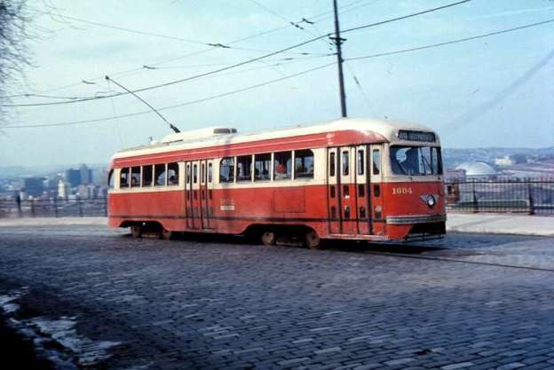
The featured image for this article is a vintage Presidents’ Conference Committee (P.C.C.) tramcar- No. 1604. It is from the 1600 series of P.C.C. cars, operated by Pittsburgh Railways and is pictured on Line 49 bound for Beltzhoover. This photograph was taken during the 1970s, © Voogd075 and licenced for reuse under a Creative Commons licence (CC BY-SA 3.0). [2]

Pittsburgh is situated at the point where the Allegheny and Monongahela rivers converge to become the  River Ohio, historically it is the most important Iron and Steel Centre in the United States.

Jackson wrote:

“It is also one of the greatest American Tramway strongholds. The present population of the city is just under 674,000 and the surrounding industrial area is densely peopled.

Public transport began in 1859, when the first horse cars ran, and up till 1902 there were a large number of competing tramway companies. In that year, these companies were brought together under the Pittsburgh Railways Company, which is still the operator today [(late ,1950)]. There are now 1,187 trams, 666 of them being P.C.C. cars. There are over 542 miles of 5ft. 2 in. gauge track. This network of 79 routes sprawls over the whole urban and suburban area, serving more than 50 communities from Sewickley in the west to Trafford and Pitcairn in the east and from Aspinwall and Etna in the north to Washington and Charleroi in the south. These latter two places are about 28 and 20 miles respectively from the centre of the city and the tramway routes serving them are of interurban character. The Charleroi line actually runs beyond that town to a point further south in the borough of Roscoe. It has a branch to Donora and California. Half-hourly service is provided on these two interurban lines.

“Many of the suburban routes have private right-of-way and reserved track.” [1: p160]
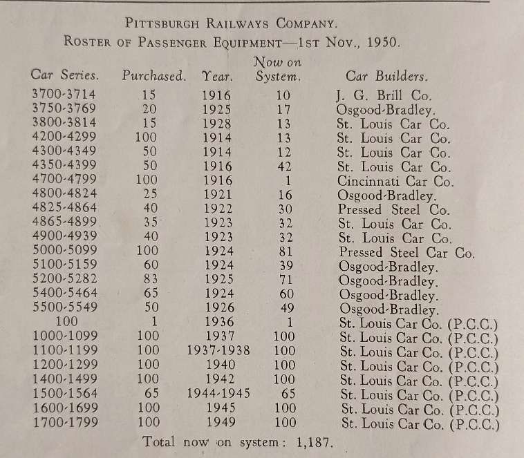
The tram fleet owned by the Pittsburgh Railway Company. [1: p160]
South Hills Junction, with P.C.C. car on service 37, © Public Domain. [1: p162]

“All tram services are designated by numbers (1 to 99, with gaps) and by names which usually indicate the district served or the principal street the route traverses, All-night cars operate in most districts between 1 a.m. and 5 a.m. “Car Stop” discs are attached to the overhead wire and at heavy loading points where more than one car loads at the same time, special signs are placed on the overhead wires reading: ‘First Car’, ‘Second Car’ and, in some cases, ‘Third Car’.

“The first P.C.C. car arrived on 26th July, 1936, and the remainder were delivered (all from the St. Louis Car Co.) as follows: 1937 (175 cars), 1938 (25 cars), 1940 (100 cars), 1942 (100 cars), 1944 (50 cars), 1945 (115 cars), 1948 (100 cars). Included in the 1945 batch was No. 1600, the first standard 1945 model all-electric, standee-window P.C.C. car to be produced. It was included as a sample model by agreement. (All subsequent P.C.C. cars ordered after 1945 were standardized to that design (with ceiling fans and monitor roof optional) replacing the electric-air operated, non-standee window P.C.C. design originating in 1935).” [1: p162]
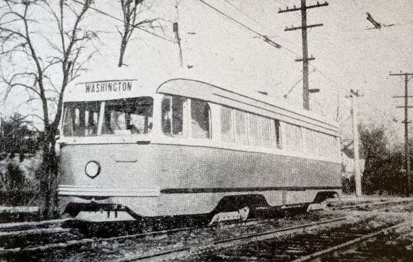
Interurban P.C.C. car No. 1613 at Cannonsburg, © Public Domain. [1: p162]

“Thirty-seven of the P.C.C. cars have been modified for interurban operation on the Washington and Charleroi lines. These modifications include replacing Clark B-2 trucks with St. Louis B-3 trucks, replacing H-B. lifeguard fenders with ‘cow-catchers’, provision of sirens, cash registers and an emergency tool kit over the windows ahead of the centre doors. The cars are also equipped with baggage racks. Some of the interurban P.C.C. cars are also equipped with radio telephones. Pittsburgh is the only system using single-ended, single-unit P.C.C. cars in long distance interurban service and the only system to use all-electric cars on this type of service. All Pittsburgh’s P.C.C. cars are one-man operated, with front entrance (P.A.Y.E.) and centre exit.” [1: p162-163]
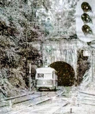
Tram No. 1614, emerging from the tunnel at South Hills Junction, running outbound from Pittsburgh to Washington Pa.) on the inter-urban route. This junction carries 6 city and 2 inter-urban services, all operated by PCC. cars. [1: p163]
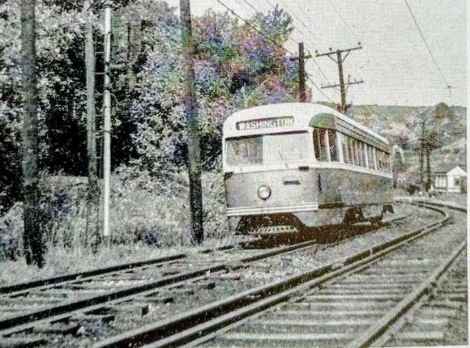
Tram No. 1647 outbound from Washington Junction to Washington (Pa.). This tramcar is one of 12 specially equipped for inter-urban service with type B3 trucks, siren, emergency tool kit and cash register. [1: p163]

At its height, the Pittsburgh Railways Company operated 666 P.C.C. streetcars, the third-largest fleet in North America, after Toronto (745) and Chicago (683). The network comprised 68 streetcar routes, of which three remain in operation in partially modernized form as part of the Pittsburgh Light Rail system. [3]

Financially, the Pittsburgh Railway Company struggled. Its lease and operate business model proved hard to support and the company declared bankruptcy twice, first in 1918 lasting for 6 years and then again in 1938, this time lasting until 1st January 1951. Company costs rose in the early twentieth century. PRC faced constant pressure from the city to improve equipment and services and workers would walk out when a pay raise was rejected.

When A.A. Jackson was writing about the network for The Modern Tramway, the company was still in bankruptcy.

On 26th July 1936, the PRC took delivery of P.C.C. streetcar No. 100 from the St. Louis Car Company. It was placed in revenue service in August 1936, the first revenue earning PCC in the world. The company went on to purchase a very large number of these vehicles in batches of 100 on most occasions. Jackson’s table giving details of the PRC fleet (above) shows that after purchasing car No. 100 in 1936: cars 1000-1099 were purchased/leased in 1937; cars 1100- 1199 were purchased/leased in 1937/1938; cars 1200-1299 were bought/leased in 1940; cars 1400-1499 arrived in 1942; cars 1500-1564 were purchased/leased in 1944/1945; cars 1600-1699 arrived in 1945; cars 1700-1799 arrived in 1949. During much of this time the PRC was bankrupt.

Despite the size of the network, it was not able to withstand the winds of change and large scale abandonments of lines began in the late 1950s, usually associated with highway or bridge work. [3]

As examples:

  • highway improvements in the Duquesne-McKeesport area resulted in the replacement of tram services with buses on 21st September 1958;
  • The replacement of the Point Bridge with the Fort Pitt Bridge precipitated the abandonment of many routes to the West End, all on 21st June 1959. In the end, the company had to abandon 27 miles (43 km) of street track in situ and was awarded $300,000 as compensation.

These events “marked the beginning of significant abandonments: 90 percent of the network was dismantled over the next decade.” [3]

A network that seemed to A.A. Jackson to have a bright future was by 1970 a pale shadow of the network in the early 1950s.

Similar things were happening in respect of the PRC Interurban network:

  • The Charleroi interurban line was cut back to the Allegheny County border at Library (Simmons loop) in June 1953. It continued to operate until the 1980s as 35 Shannon-Library and became the southern portion of 47L Library via Overbrook when Light Rail Vehicles (LRVs) replaced [trams]. The [tram] loop was removed in 2004. In 2010 this line became the Blue Line – Library, and in 2020 was renamed the Silver Line – Library.” [3]
  • The Washington line was cut back to the county boundary at Drake in August 1953 and eventually became the 36 Shannon-Drake. This in turn became the southern portion of 42 South Hills Village (excluding the new link from Dorchester to South Hills Village, which was built in 1984). The final portion of the interurban from Dorchester to Drake was renamed 47 Drake, finally closing in 1999 and bringing to an end P.C.C. Streetcar operation in Pittsburgh.” [3]
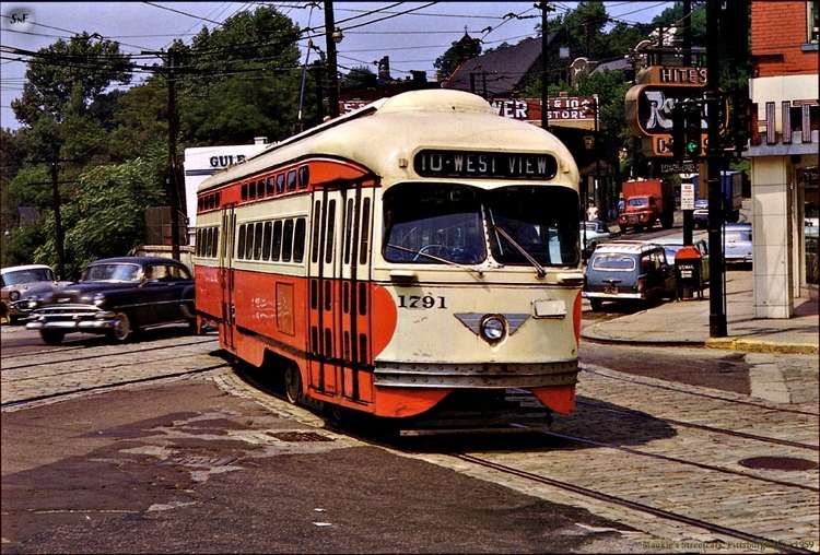
P.C.C. No. 1791, route 10 West View. [4]

Pittsburgh Light Rail

The Pittsburgh Light Rail is the successor to the original Pittsburgh Railway Company. Some residual parts of the old network are in use as part of the Pittsburgh Light Rail system.

The Pittsburgh Light Rail (commonly known as The T or the Trolley) is a 26.2-mile (42.2 km) light rail system in Pittsburgh, Pennsylvania, serving the city and surrounding suburbs. The system operates as a deep-level subway in Downtown Pittsburgh, but runs mostly at-grade in suburban areas south of the city. It is largely linear in a north–south direction, with one terminus near the central business district and two termini in the South Hills. The system is owned and operated by Pittsburgh Regional Transit.” [5]
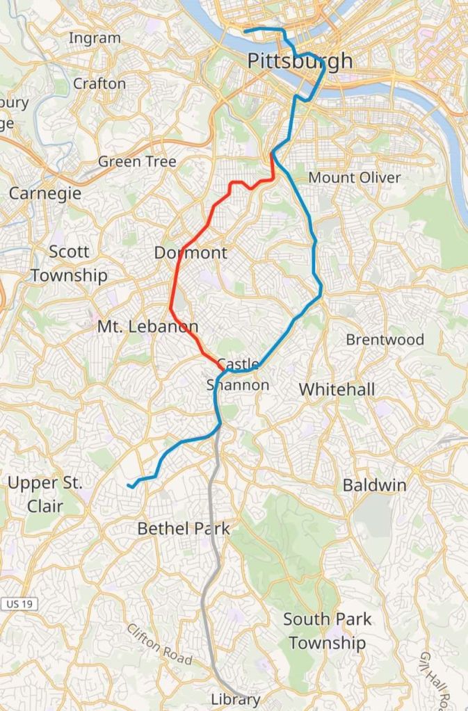
The Pittsburgh Light Rail network is made up of three lines – the Blue Line, the Red Line and the Silver Line. This map shows the three lines superimposed on an OpenStreetMap base layer. [6]

The system is one of the surviving first-generation streetcar systems in North America, with portions of the network dating to 1903, when they were operated by the Pittsburgh Railways Company. It is one of three light rail systems in the United States that continues to use the broad 5 ft 2 1⁄2 in (1,588 mm) Pennsylvania trolley gauge rather than the 4 ft 8 1⁄2 in (1,435 mm) standard gauge. In 2025, the system had a ridership of 3,104,400.” [5]

On 1st March 1964, the PRC system “was acquired by the newly established Port Authority of Allegheny County (PAT), which also assumed operations of more than 30 other transit companies in the region, including bus operators and the incline lines. The state hoped the consolidation would help stabilize the system as the private companies all had separate fare structures, labour agreements, and, in some cases, overlapping routes, while ridership had declined in the preceding years.” [5]

PAT undertook a program of consolidation and modernisation. MOT tram routes were converted to bus operation which it believed reflected lower operating and maintenance costs and reduced capital requirements. “By the early 1970s, only a small number of trams routes remained, primarily those using the Mount Washington Transit Tunnel to reach the South Hills, retained in part because they operated on private rights-of-way separate from street traffic.” [5]

PAT also planned to introduce guided busways. The programme was given the name ‘Skybus’. However investment was curtailed in the late 1970s because of public opposition.

Stage I

Planning shifted toward reconstructing the remaining tram lines as a modern light rail system, resulting in a ‘Stage I’ plan, the first phase of a broader program to develop a new light rail network. “The project included reconstruction of the Beechview line, construction of a short branch to South Hills Village, and a 1.1-mile (1.8 km) subway through downtown. Reconstruction of the existing line included double-tracking formerly single-track segments, replacing jointed rail with continuous welded rail, and upgrading the overhead power system to modern catenary.” [5]
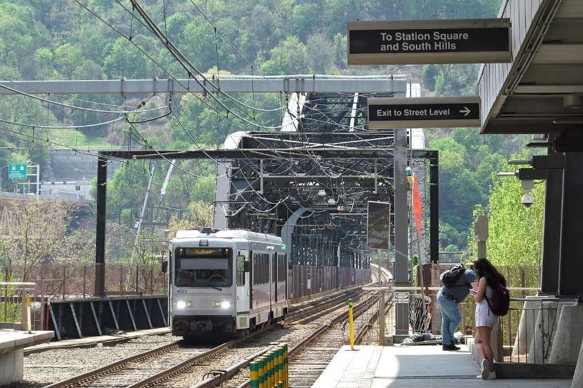
A Blue Line train crosses the Panhandle Bridge and approaches First Avenue station in April 2023, © Cbaile19 and licenced for reuse under a Creative Commons licence (CC0). [8]

“Only the busiest stops were rebuilt with high-level platforms, while lower-ridership stops retained low-level, street-level boarding. Because this work preceded the Americans with Disabilities Act of 1990, full systemwide accessibility was not required. The design also allowed continued operation of P.C.C. cars on unmodified portions of the network, with some shared stations providing both high- and low-level boarding.” [5]

Construction started at the end of 1980. The first modern light rail cars began operating on 15th April 1984. A full service across the subway, the rebuilt Beechview line, and the South Hills Village branch was operating by July 1985. [5]

Funding for upgrades to the segment of the line between Castle Shannon and South Hills Junction was approved in May 1985, including $20 million in federal grants. The entire Stage I project was declared complete on 22nd May 1987, at a total cost of $522 million, which included the purchase of 55 light rail vehicles. [5]
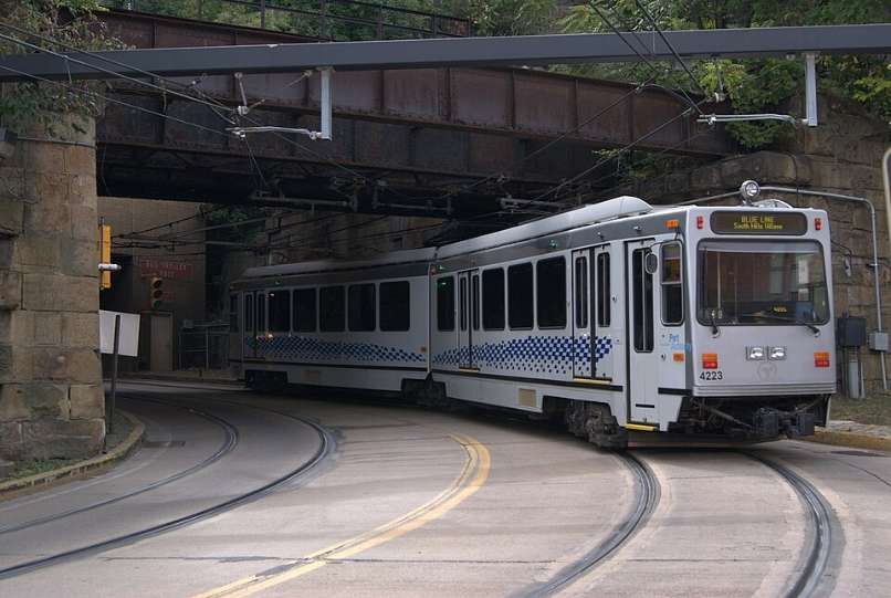
Southbound Blue Line train departs Station Square, heading into the Mount Washington Transit Tunnel. The Blue Line operates between Pittsburgh’s North Shore and South Hills Village via Downtown and the neighborhoods of Knoxville and Overbrook, as well as Castle Shannon and Bethel Park. The line operates over the Overbrook line and the South Hills Village line, © kaffeeeinstein and licenced for reuse under a Creative Commons licence (CC BY-SA 2.0). [9]

Stage II – The Overbrook Line

“The line from South Hills Junction to Castle Shannon via Overbrook (now called the Overbrook Line, part of the Blue and Silver lines) was first constructed by the Pittsburgh and Castle Shannon Railroad (P&CSRR) between 1872 and 1874. In 1905, Pittsburgh Railways leased the route, and between 1909 and 1910, converted it to dual gauge, retaining the existing narrow gauge for the coal-hauling trains and adding the broad 5 ft 2 1⁄2 in (1,588 mm) Pennsylvania tram gauge for passenger service using trams (streetcars). While the line was electrified with overhead power, the coal trains continued to use existing steam locomotives.” [5]

The Beechview line was rebuilt during the 1980s, but the Overbrook line remained largely unchanged and continued to be operated using P.C.C. cars. “The reconstruction of this line would be part of the Stage II project, to be performed at a future date pending additional funding. However, the condition of the track and infrastructure of the Overbrook line continued to deteriorate and in 1993, Pittsburgh Regional Transit determined the line to be unsuitable for safe operation in its current state and suspended service on the line. The line remained dormant until 1999, when the PRT broke ground on the Overbrook Line reconstruction project.” [5]

The rebuilt Overbrook line was essentially an entirely new line built along the original line’s right of way. As had been done with the Beechview line prior, the rebuilt line was completely double-tracked with continuously welded rail, pandrol clip fixation, upgraded catenary and signaling, and other improvements. The rebuilt line included eight accessible stations with high-level platforms; unlike the Beechview line, no street-level stops were retained. The Overbrook line reopened in June 2004, at a total cost of $386 million, including the cost of purchasing 28 LRVs. Coinciding with the opening, Pittsburgh Regional Transit purchased 28 additional light rail cars to support the line and increase overall system capacity. At this time, the 55 existing cars were completely rehabilitated as well. In addition, as part of the Stage II project, upgrades to the traction power network, Operations Control Centre, and signals and communications had been implemented.” [5]
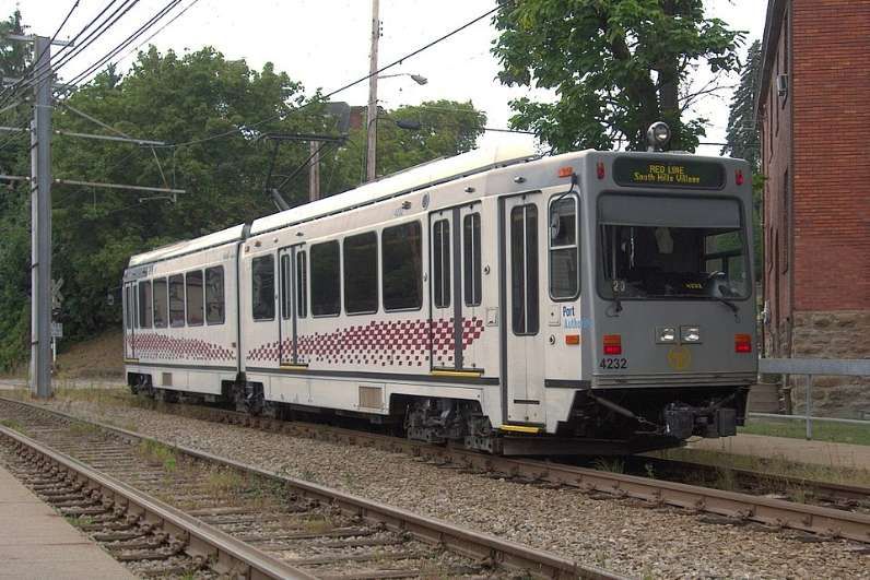
Southbound Red Line train at Westfield, September 2015. The Red Line runs between South Hills Village and Downtown Pittsburgh via the Beechview neighbourhood, © Cbaile19 and licenced for reuse under a Creative Commons licence (CC0). [10]
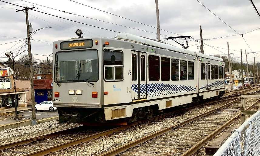
Northbound Silver Line train near Mesta, December 2020. The Silver Line operates between Pittsburgh’s North Shore and Library via Downtown and the neighborhoods of Knoxville and Overbrook, as well as Castle Shannon and Bethel Park, © Sebileis2017 and licenced for reuse under a Creative Commons licence (CC BY-SA 4.0). [11]

North Shore Connector

In January 1999, Pittsburgh Regional Transit began planning for the construction of a light rail line to connect Pittsburgh’s Downtown and North Shore. Federal funding was approved for the extension on 6th February 2004.

The main project involved twin-bore tunnels below the Allegheny River to connect a refurbished Gateway Station, which was the former Downtown terminus, to North Side station, located just west of PNC Park, and Allegheny station, located just north of Heinz Field. The completed project opened to the public on 25th March 2012. The final cost was $523.4 million. [5]
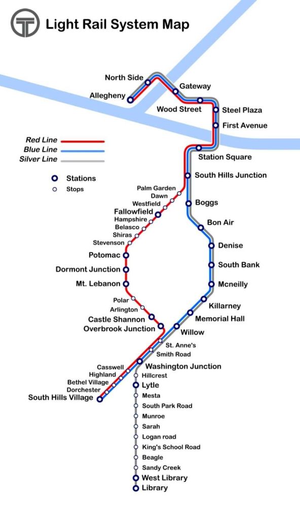
Route map of the three lines on the Pittsburgh light rail system, © Haha169 and licenced for reuse under a Creative Commons licence (CC BY-SA 4.0). [7]

2024–2028 Rail Replacement Projects

From 2024 to 2028, PRT is undertaking a system-wide program of track rehabilitation across the network. The work includes phased closures, single-tracking, and temporary service reroutes. … In 2024, sections of the Red Line were closed for track replacement, resulting in single-tracking operations, shuttle bus substitutions, and a temporary Red Line Short service between Dormont Junction and Overbrook Junction. During part of this period, Red Line trains were also rerouted over the Blue Line alignment.” [5]

That programme continues in 2026.

Future light-rail and rapid-transit extensions are mapped out in the 25-year ‘NEXTransit‘ plan. [12]

Rolling Stock

The majority of Light Rail Vehicles (LRVs) in use on the network are Siemens SD-400 units, introduced to the network between 1985 and 1987. These units were rebuilt by CAF (Construcciones y Auxiliar de Ferrocarriles) in 2005‍–‍2006 and are currently numbered from 4101‍–‍4155. (Seven units salvaged for parts, then scrapped.) CAF also supplied 28 of their own design of LRV between 2003 & 2004. [5]

References

  1. A. A. Jackson; An American Tramway Stronghold; in The Modern Tramway, Volume 14, No. 163, July 1951, p160 & p162-163.
  2. https://commons.wikimedia.org/wiki/File:PCC_uit_de_1600_serie_op_lijn_49_BELTZHOOVER.jpg, accessed on 18th May 2026.
  3. https://en.wikipedia.org/wiki/Pittsburgh_Railways, accessed on 18th May 2026.
  4. https://en.wikipedia.org/wiki/Pittsburgh_Railways#/media/File%3APCC_uit_de_1700_serie_op_lijn_10_WEST_VIEW.jpg, accessed on 18th May 2026
  5. https://en.wikipedia.org/wiki/Pittsburgh_Light_Rail, accessed on 18th May 2026.
  6. https://en.wikipedia.org/wiki/Pittsburgh_Light_Rail#/map/0, accessed on 18th May 2026.
  7. https://en.wikipedia.org/wiki/Pittsburgh_Light_Rail#/media/File%3APittsburgh_T_System_map.png, accessed on 18th May 2026.
  8. https://en.wikipedia.org/wiki/Pittsburgh_Light_Rail#/media/File%3APanhandle_Bridge_from_First_Avenue_Station%2C_2023-04-21.jpg, accessed on 18th May 2026.
  9. https://en.wikipedia.org/wiki/Blue_Line_(Pittsburgh)#/media/File%3AT_Lightrail_an_der_Station_Square_03.jpg, accessed on 18th May 2026.
  10. https://en.wikipedia.org/wiki/Red_Line_(Pittsburgh)?wprov=rarw1#/media/File%3ARed_Line_Car%2C_Beechview%2C_2015-09-10%2C_02.jpg, accessed on 18th May 2026.
  11. https://en.wikipedia.org/wiki/Silver_Line_(Pittsburgh)?wprov=rarw1#/media/File%3ASilver_Line_(cropped).jpg, accessed on 18th May 2026.
  12. https://nextransit.network, accessed on 18th May 2026.
Shaker Heights Rapid Transit Lines – Modern Tramway Vol. 12 No. 137, May 1949

Modern Tramway talks, in 1949, of the Shaker Heights Rapid Transit (SHRT) Lines as “A high speed electric light railway entirely on reserved track, connecting a beautiful high class residential district with the centre of a large city. affording such speedy and efficient service that the car-owning suburban residents prefer to use it and park their cars on land provided by the line; a system which makes a handsome profit and has recently taken delivery of 25 of the most modern type of electric rail units in the world [which] are only some of the outstanding facts about Shaker Heights Rapid Transit.” [1: p101]

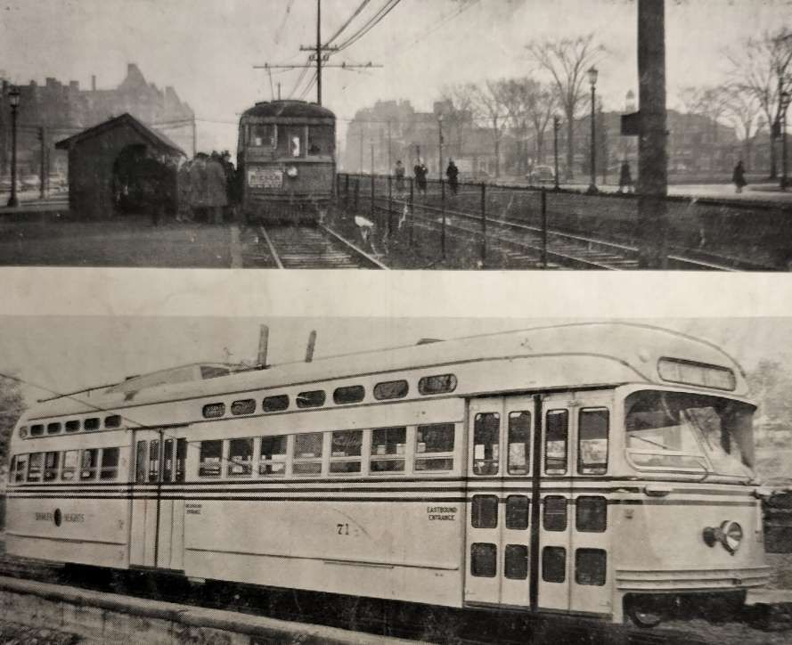
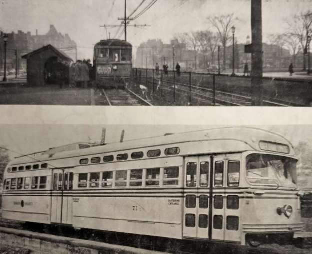
Two images from Modern Tramway which show: first , a station in Shaker Heights which shows the central reservation and a car of standard type; second, a PCC car equipped for multiple-unit operation, one of a fleet of 25 delivered in 1948. [1: p112]

The network was created by the Van Sweringen brothers and purchased after their bankruptcy, and a period of 9 years in receivership, by Cleveland City Council in 1944. [2]

The official ownership details down the years are:

1913–1920: Cleveland & Youngstown Railroad
1920–1930: Cleveland Interurban Railroad
1930–1935: Metropolitan Utilities
1935–1944: Union Properties (47%), Guardian Savings and Trust (33%) and Cleveland Trust (20%)
1944–1975: City of Shaker Heights
1975–present: Greater Cleveland Regional Transit Authority.” [4]

The SHRT connected the city of Cleveland, Ohio, with the largest residential area known as Shaker Heights, six miles East.

The Van Sweringen brothers planned the line “in the early 1900’s as part of a land development scheme, … to serve the district that would grow up on the Heights and beyond, and the charter was obtained in 1907. The land development was planned around the line, and the engineers allowed for a railway area 90 feet wide through the property with 50 feet of open space each side of the tracks (room for four tracks and a grass verge on each side). Building was delayed by the First World War and the line was not opened until 11th April, 1920.” [1: p101]

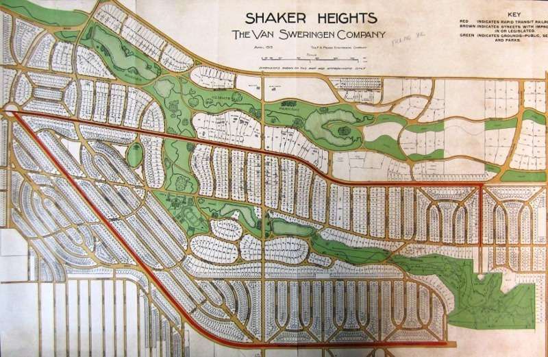
In this 1919 map of Shaker Heights prepared for the Van Sweringens by the F. A. Pease Engineering Co., the relationship between the construction of the two lines of the new Shaker Rapid Transit and the proposed expansion of residential development in the Shaker Lakes Park area is clearly observable. Shaker Square is at the left of this map, © Shaker Historical Society, Public Domain. [11]
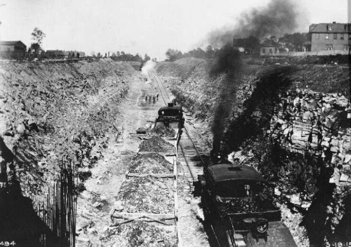
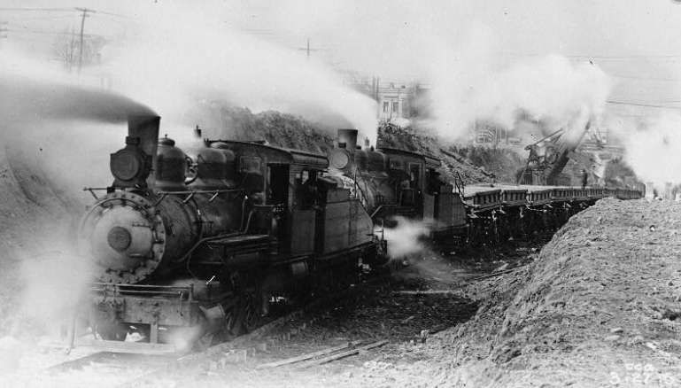
Construction work on the Shaker Heights Tramway with steam-powered construction trains, circa. 1919/1920. Steam construction trains on the east side of Cleveland, just west of Shaker Square, © Public Domain. [7]
Another view of steam locomotives at work on the construction of the line, circa. 1919/1920. [7]
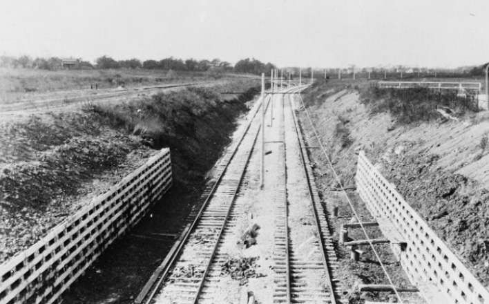
The newly built tramway West of Shaker Square (Moreland Circle), at time of construction, circ. 1920. [7]
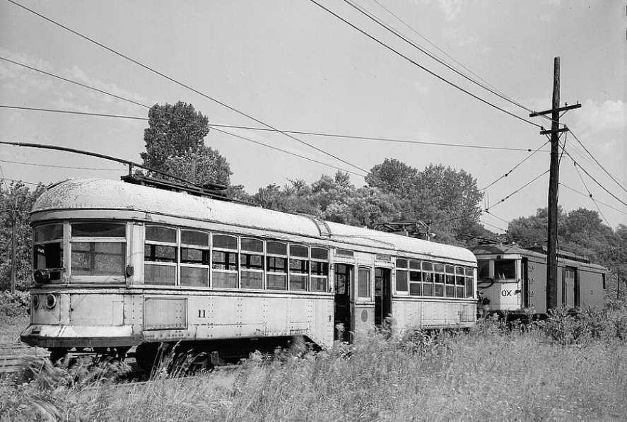
Original rolling-stock on the Shaker Heights Rapid Transit Line. [7]
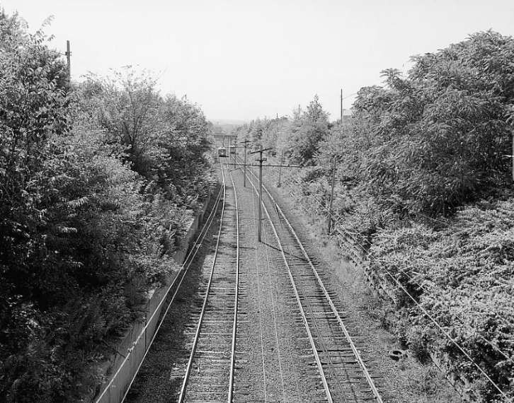
Later general view of the mainline, east of Shaker Square. [7]

Tower City Station to Shaker Square

On 20th July 1930, Shaker Rapid Transit cars began using the Cleveland Union Terminal (CUT), after the Terminal Tower opened. [12]

Before this, on 17th December 1913, trams began operating on the first 1.6-mile segment in the median of what would become Shaker Boulevard, from Coventry Road east to Fontenay Road. [12] The line was grandly named ‘The Cleveland & Youngstown Railway’.

In 1915, the tram service was extended to Courtland Boulevard. In 1920 it became apparent that the plan to link Cleveland to Youngstown would not succeed and the line was renamed as ‘The Cleveland Interurban Railway’ (CIRR). In April of that year, the Van Sweringen brothers opened a segregated (trams separate from other rail and road traffic) line from East 34th Street to Shaker Heights with their trams using the urban tram (streetcar) network to reach the city centre. [12]

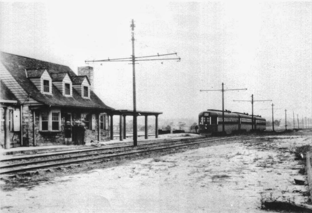
In 1923, the Standard Oil Company built the Coventry Road Station for $17,500. … In 1924, the Shaker trains were referred to as ‘the private right-of-way rapid transit line’, but calling it ‘the rapid’ probably dates back further than that.” [12]

The historic station at Tower City (1927 onwards) was the early terminus of the Shaker Heights Rapid Transit Lines which were extended along the Cleveland Waterfront.

The modern Tower City Station is the central station of the Cleveland, Ohio RTA Rapid Transit system, served by all lines: Blue, Green, Red and Waterfront. The station is located directly beneath Prospect Avenue in the middle of the Avenue shopping mall. The station is only accessible through the Tower City Center shopping complex. [13]

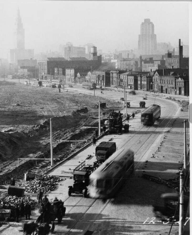
Shaker Rapid Transit Tracks on Cleveland city streets, East Side, prior to opening of sub-grade tracks into Terminal Tower project, 1927, © Public Domain. [7]
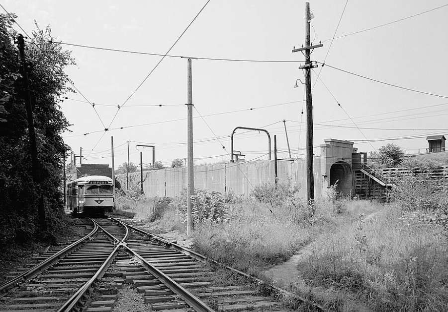
View showing tracks & reinforced concrete tunnel north of Shaker Rapid Transit car yards, Kingsbury Run, Cleveland, © Public Domain. [7]
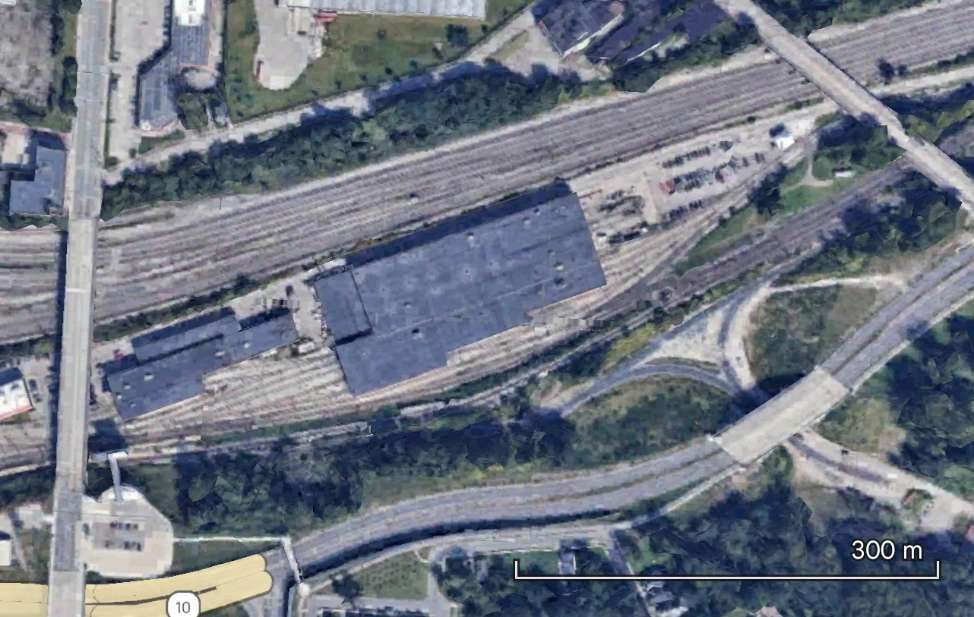
The depot for the tramway network – the RTA Central Depot. [Google Earth, January 2025]
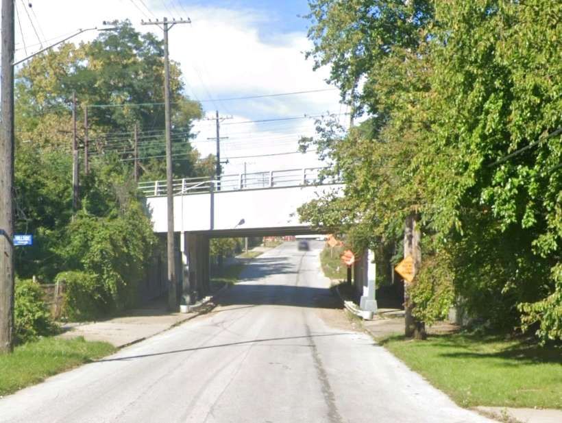
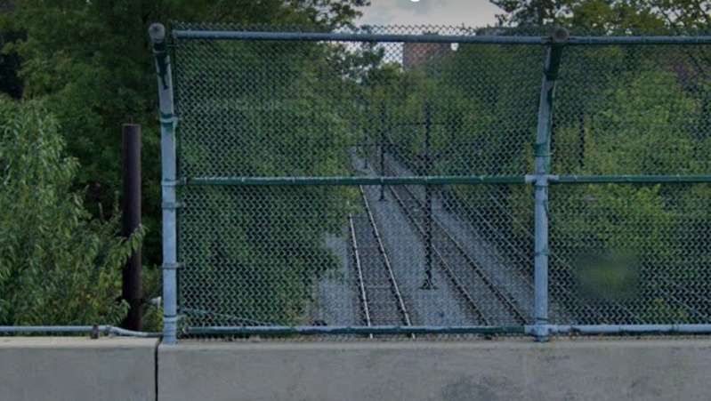
Looking North on East 75th Street through the bridge carrying the tramway. [Google Streetview, October 2022]
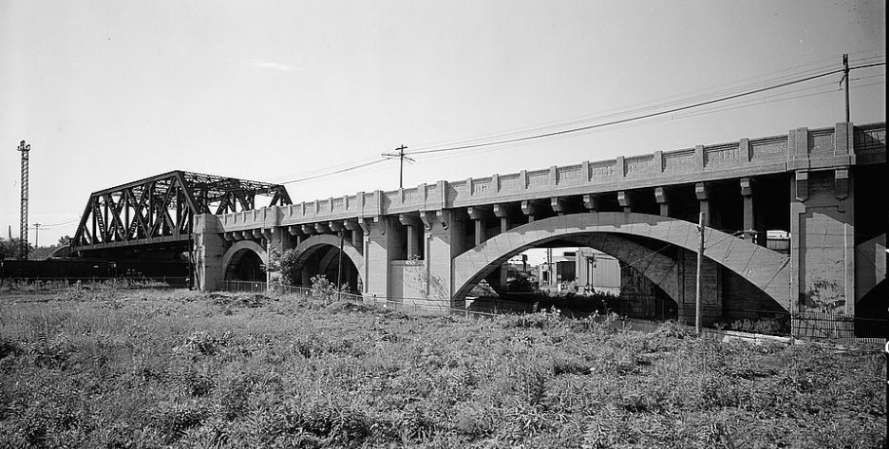
On the way East out of Cleveland the tramway was elevated passing over this truss bridge and reinforced concrete viaduct at East 80th Street in Cleveland, © Public Domain. [7]
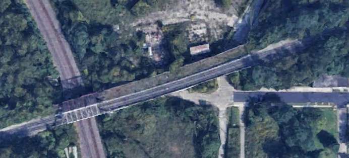
The same bridge from above. [Google Earth, January 2025]
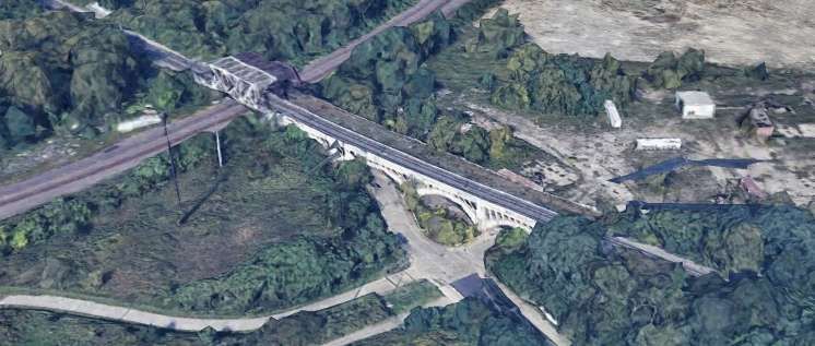
And a 3-D image of the same bridge. [Google Earth, January 2025]
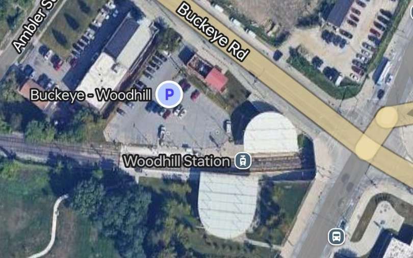
Woodhill Station in the 21st century. [Google Maps, January 2025]
The line East towards Shaker Square from the junction of Buckeye Road and Woodhill Road. Woodhill Station is behind the camera. [Google Streetview, September 2022]
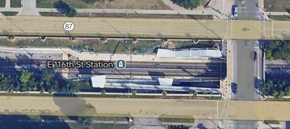
A little further to the East is East 116th Street Station. East 116th Street crosses the line at the right of this picture. [Google Maps, January 2025]
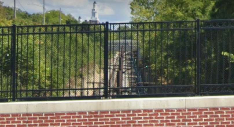
The view East towards Shaker Square from East 116th Street. [Google Streetview, September 2022]
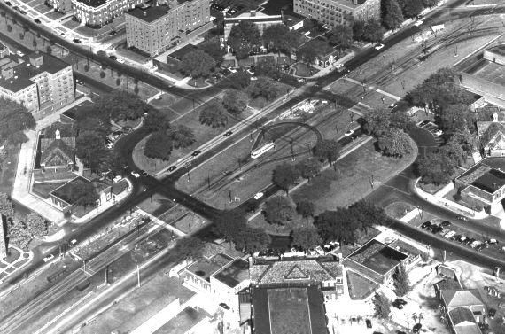
An aerial view of Shaker Square in 1951, © Unknown. [14]

A few photographs between Shaker Square and Green Road. ….

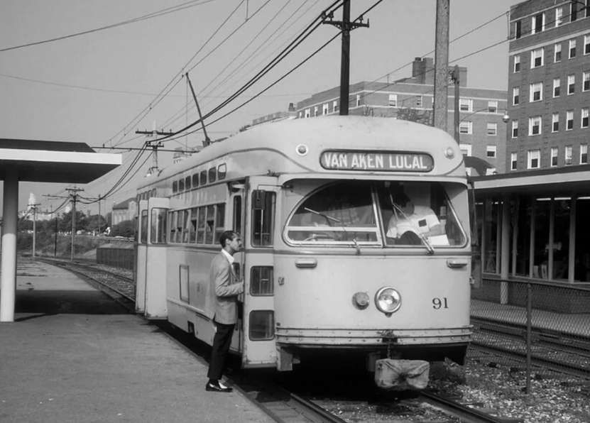
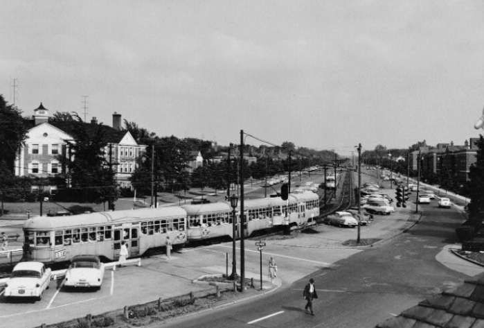
Tram No. 91 at Shaker Square in 1965. This view looks West towards the city centre, © Unknown. [10]
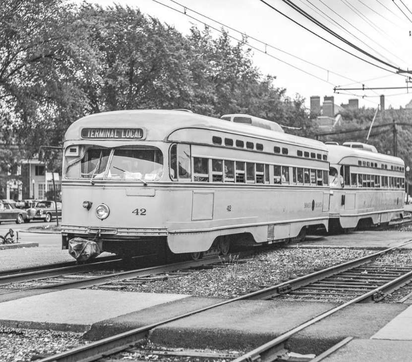
Tram No. 42 at Shaker Square in the late 1960s. No. 42 is running in multiple unit (MU) mode with another Shaker Heights Rapid Transit PCC, © Robert Farkas. [9]
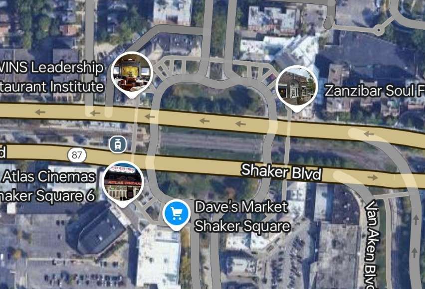
Shaker Square in the 21st century. The tram station is on the left of the image. The junction to the right of Shaker Square is the junction between the lines to Green Road and Moreland. [Google Maps, January 2025]
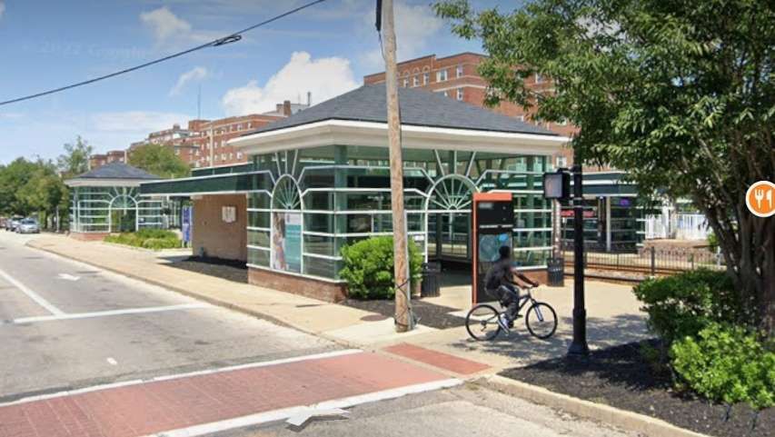
Two views of Shaker Square Station from the East in the 21st century. [Google Streetview, July 2022]
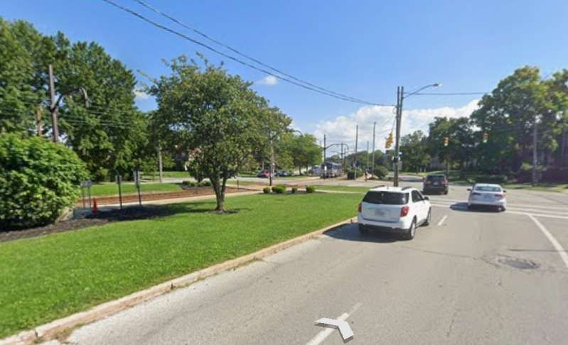
Green Road Station seen from the flyover on South Green Road. [Google Streetview, April 2023]
The end of the line at Green Road. The turnabout at Shaker Blvd. In the distance can be seen graded right-of-way, with poles, for 1937 expansion that was never constructed, © Public Domain. [7]
The same loop seen looking East from South Green Road in 2023. [Google Streetview, April 2023]
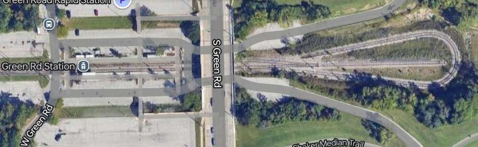
South Green Road is in the centre of this extract from Google Maps. The Station is to the left, the return loop to the right. [Google Maps, January 2025]

A few photographs taken along the Moreland Line. …..

Van Aken Boulevard Line/Moreland Line at Drexmore Road, Shaker Rapid Transit, 1956, © Public Domain. [7]
A ground-level view of Drexmore East Station and the junction between Drexmore Road and Van Aken Boulevard in the 21st century. [Google Streetview, September 2022]
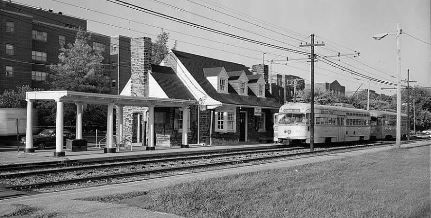
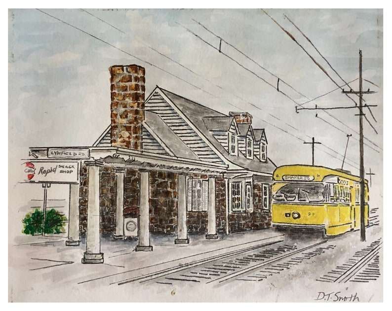
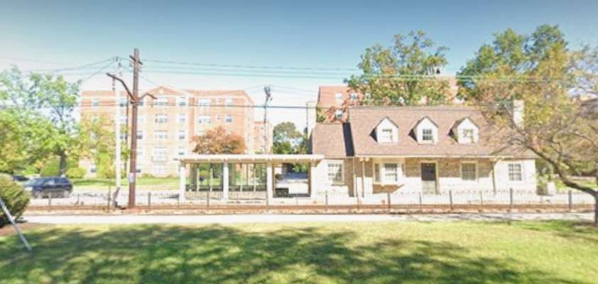
General view of Lynnfield Station, Van Oken Line/Moreland Line, Shaker Heights Rapid Transit; now an antique store, © Public Domain. [7]
An artist’s sketch of the same station. [8]
The same building in the 21st century, now an antiques store. [Google Streetview, October 2021]
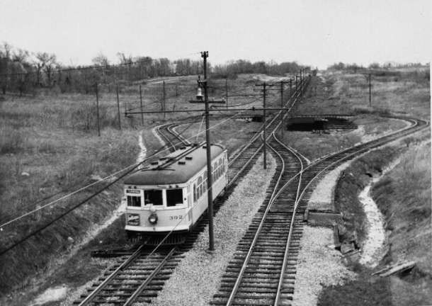
Warrensville Center Road Loop, Shaker Boulevard Line of Rapid Transit, 1936, © Public Domain. [7]
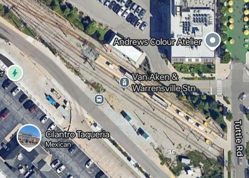
An overview of Warrensville Station. [Google Maps, January 2025]
The Warrensville terminus of the More look and Line. [Google Streetview, April 2023]
The end of the line as seen from Tuttle Road in the 21st century. The loop seen in the monochrome image above has been removed. [Google Streetview, April 2023]

The first cars were ordinary tramcars from the Cleveland City system, specially refitted for fast service. “In July, 1930, the SHRT (which had formerly entered the city over street tracks) was brought into the main line railway terminus over existing railway tracks. By this time the line extended for 9.5 miles from the Union Terminal Building in Cleveland to Green Road, at the far end of Shaker Heights; in addition, there was a branch line to Moreland.” [1: p101]

The two lines in the suburbs were extended. The Moreland line in 1929, eastward from Lynnfield (its original terminus) to Warrensville Center Rd. The Shaker line, in 1937, was extended from Warrensville Center Rd. to a new loop at Green Rd. [2]

Under the main floor of the Union Terminal Building, the SHRT tracks are adjacent to the main line railway platforms. The six miles out to Shaker Square are on an ascending grade along the valley of the Cuyahoga river, and are entirely on private right-of-way; from Shaker Square onwards, the line runs through a grass reservation in the centre of Shaker Boulevard as far as Green Road Terminal.” [1: p101]

The branch to Moreland, a suburb of smaller type property, diverges about 500 feet east of Shaker Square station, running in a south-easterly direction; at this terminus are storage yards with car parking facilities inside a U track formation.” [1: p101]

The overhead is compound catenary out to East 55th Street, Cleveland, and normal trolley-wire elsewhere; the line is signalled throughout and road crossings are well spaced.” [1: p101]

The journey from Green Road outer terminus to the Union Terminal Building in downtown Cleveland “is covered in 22 minutes including 16 stops en route. The six miles from Shaker Square down into Cleveland (which include four curves with speed restriction) are covered in 8-9 minutes by non-stop cars. The up-grade increases the express timing on the outward journey to Shaker Square to 12 minutes.” [1:p101]

When the City Council bought the line in 1944, the Director of Transportation, Mr. Paul K. Jones, began to modernise the existing fleet and to look around for new cars. He chose PCC cars with multiple unit equipment, and after trial runs in 1946 with a PCC-MU car ordered for Boston’s tramways, he ordered 25, to be modified to suit the SHRT’s demands and these were delivered towards the end of [1948]. They have Sprague Multiple Unit Control and are equipped for MU operation in trains of up to six cars. Other details are: Seating capacity. 62; overall length, 52ft. 7in.; overall height, 10ft. 4in.; width, 9ft.; truck wheel base, 6ft. 10in.; livery, canary yellow.” [1: p101]

A new $60,000 sub-station was built by 1949 in Shaker Heights which ensured adequate power for the PCC cars. Other improvements undertaken were “the doubling of car parking space at stations and an increase in service frequency.” [1: p101]

Extensions of the SHRT were, in 1949, considered likely; at that time, the line had been graded beyond Green Road as far as Gates Mills and steel poles had been erected part of the way. (This extension never occurred even though the preparatory work had been undertaken.) [7]

The Moreland Branch had been graded south to the Thistledown Race Track beyond Warrensville and there was little doubt, at that time that this extension would be completed. It turns out that this extension also never came to fruition.

In Cleveland itself, the City Council … asked for 31 million dollars for the purpose of financing extensions of its city lines east and west of the city. The East Side line was laid out and partly graded by the original builders of the SHRT; it left the Heights line at East 60th Street and needed, at the time of writing of the article in Modern Tramway, only a few months’ work to complete.” [1: p101]

Snow [had] no effect on the operation of the SHRT and the line [carried] on when local bus and trolley bus lines [had] ceased … in the severe winter of 1947-8; and all the year round, as mentioned before, the owners of the $75,000 homes of Shaker Heights [left] their cars behind and [travelled] into town by the faster and more reliable means so amply provided.” [1: p102]

In 1955 the Cleveland Transit System (which was formed in 1942 when the City of Cleveland took over the Cleveland Railway Company) opened the first section of the city’s new rapid transit line, now known as the Red Line. It used much of the right-of-way and some of the catenary poles from the Van Sweringen’s planned east-west interurban line adjacent to the NYC&StL tracks. The first section of the CTS rapid transit east from Cleveland Union Terminal included 2.6 miles (4.2 km) and two stations shared with the Shaker Heights Rapid Transit line, necessitating split platforms with low-level sections (for Shaker Heights rapid transit cars) and high-level sections (for CTS rapid transit cars).” [4]

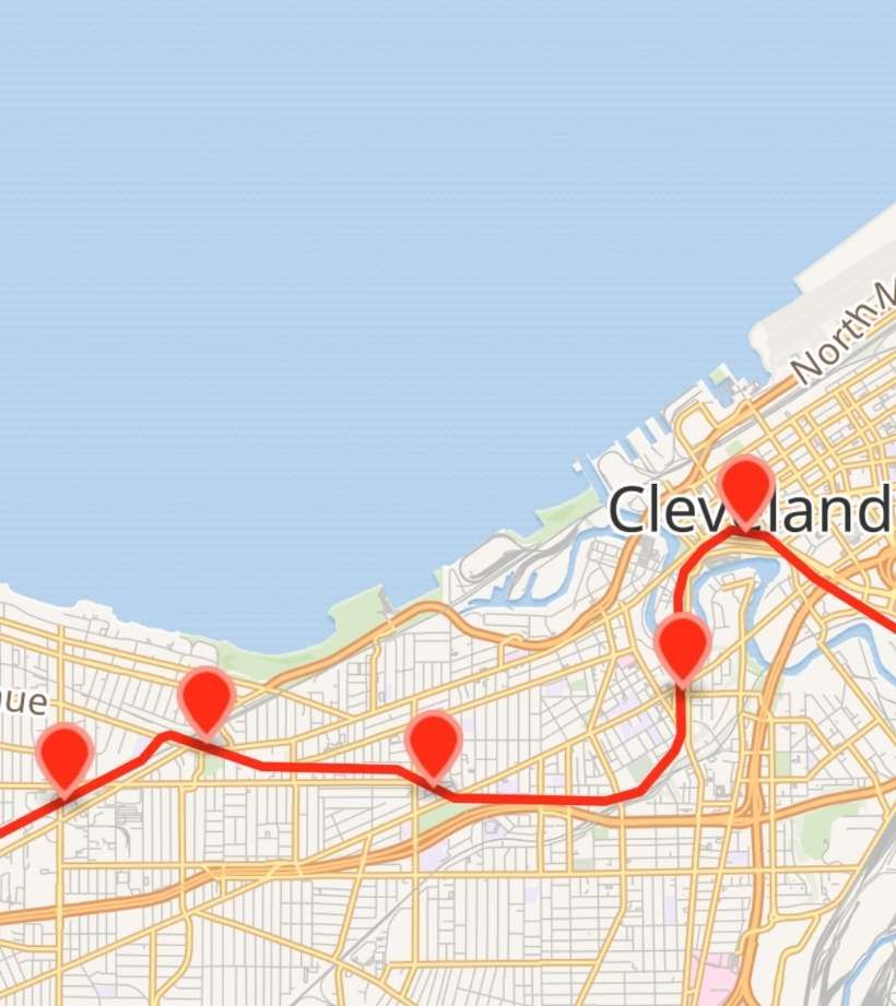
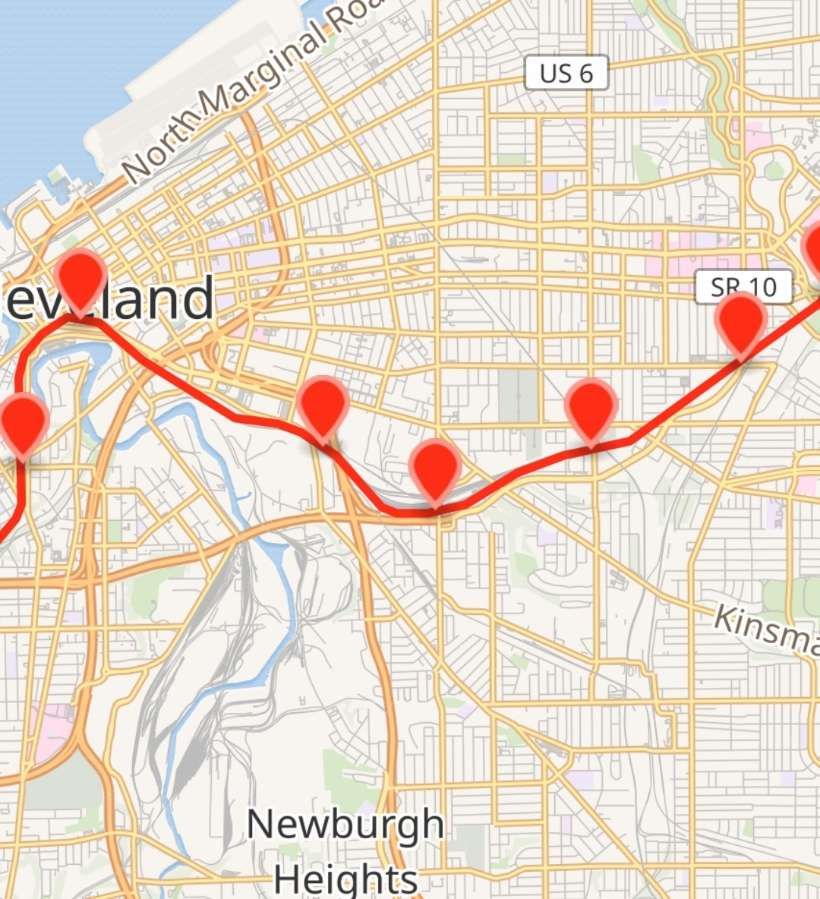
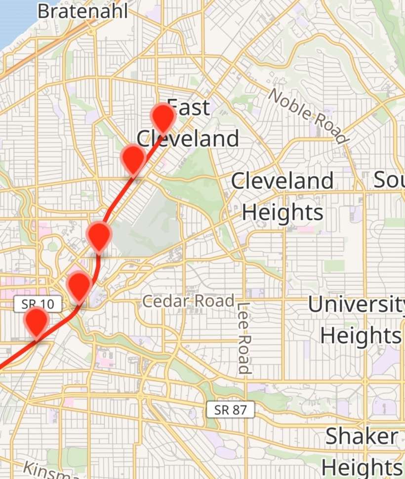
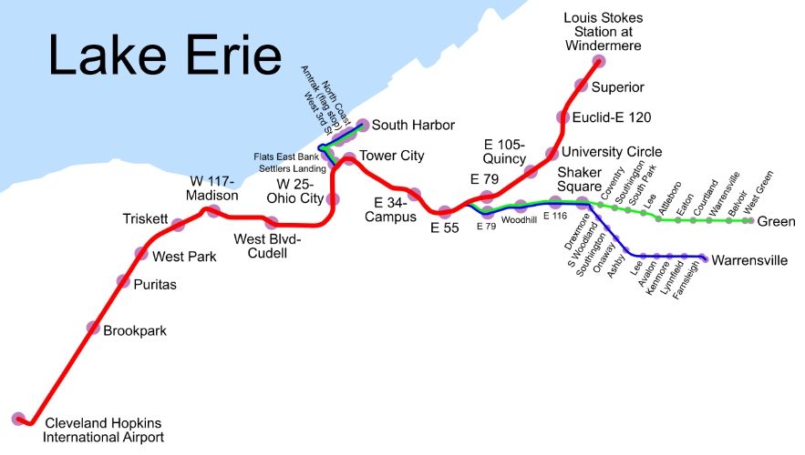
In the 21st century, the Red Line (formerly and internally known as Route 66, also known as the Airport–Windermere Line) is now “a rapid transit line of the RTA Rapid Transit system in Cleveland, Ohio, running from Cleveland Hopkins International Airport northeast to Tower City in downtown Cleveland, then east and northeast to Windermere. 2.6 miles (4.2 km) of track, including two stations (Tri-C–Campus District and East 55th), are shared with the light rail Blue and Green Lines; the stations have high platforms for the Red Line and low platforms for the Blue and Green Lines. The whole Red Line is built next to former freight railroads. It follows former intercity passenger rail as well, using the pre-1930 right-of-way of the New York Central from Brookpark to West 117th, the Nickel Plate from West 98th to West 65th, and the post-1930 NYC right-of-way from West 25th to Windermere.” [5]

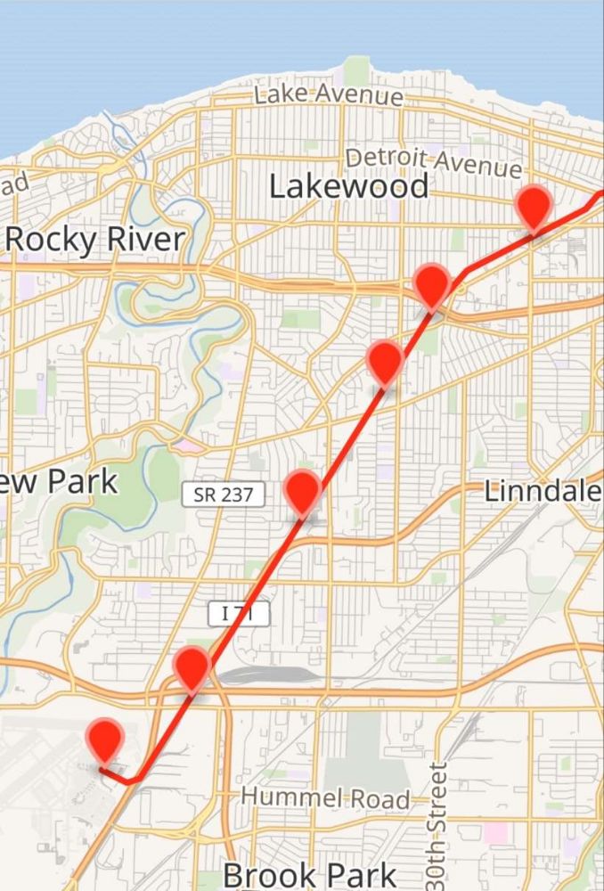
The Red Line is shown on the four extracts from OpenStreetMap below. [5]

These four map extracts show the full length of the Red Line from the airport in the West to East Cleveland. [5]

In the 21st century the two original Shaker Heights routes form the Blue Line and the Green Line as part of Cleveland, Ohio’s Rapid Transit System.

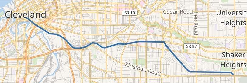
The Blue Line (formerly known as the Moreland Line and the Van Aken Line, and internally as Route 67) is a light rail line of the RTA Rapid Transit system in Cleveland and Shaker Heights, Ohio, running from Tower City Center downtown, then east and southeast to Warrensville Center Blvd near Chagrin Blvd. 2.6 miles (4.2 km) of track, including two stations (Tri-C–Campus District and East 55th), are shared with the rapid transit Red Line, the stations have low platforms for the Blue Line and high platforms for the Red Line. The Blue Line shares the right-of-way with the Green Line in Cleveland, and splits off after passing through Shaker Square.” [3]

The Blue Line from Cleveland to Shaker Heights shown on OpenStreetMap. [3]

The Green Line (formerly known as the Shaker Line) is a light rail line of the RTA Rapid Transit system in Cleveland and Shaker Heights, Ohio, running from Tower City Center downtown, then east to Green Road near Beachwood. 2.6 miles (4.2 km) of track, including two stations (Tri-C–Campus District and East 55th), are shared with the rapid transit Red Line; the stations have low platforms for the Green Line and high platforms for the Red Line. The Green Line shares the right-of-way with the Blue Line in Cleveland, and splits off after passing through Shaker Square.” [4]

This map shows the extent of the three lines – red, blue and green, © Public Domain. [6]

Tram Cars

Tram cars used on the Shaker Heights lines since 1920 include: the 1100-series and 1200-series centre-entrance fleet; the colourful PCC cars; and the current fleet of Breda LRVs which have operated the line since 1982. [15]

Cleveland’s 1100-series and 1200-series center-door cars were built in the mid-1910s.  “Not only were these cars distinctive and immediately identifiable as Cleveland cars, but many of them outlasted the Cleveland street railway itself.  This was because the suburban streetcar route to Shaker Heights, barely on the drawing board when the center-door cars were built, bought a handful of 1200-series cars to hold down service when it was new.  For years these cars were the backbone of service to Shaker Heights until the last of them were finally retired in favor of PCC cars in 1960.” [16]

A three-car train of 1200-series centre-door cars waits at what was then the Lynnfield Road terminus of the South Moreland Boulevard line around 1923 during the early years of the Shaker Heights operation.  The line was extended to Warrensville Center Road in 1930 and in 1950 South Moreland Boulevard was renamed Van Aken Boulevard. This photograph  is held in  Shaker Historical Museum photograph collection. © Public Domain. [16]

Cleveland’s PCC Trams began arriving in the late 1940s, as we have already noted. PCC (Presidents’ Conference Committee) trams were streetcars of a design that was first “built in the United States in the 1930s. The design proved successful domestically, and after World War II it was licensed for use elsewhere in the world where PCC based cars were made. The PCC car has proved to be a long-lasting icon of streetcar design, and many remain in service around the world.” [17]

The Shaker Heights Rapid Transit network purchased 25 new PCC cars and 43 second-hand cars. A total of 68: the original 25 Pullman cars were extra-wide and had left-side doors. The second-hand cars were: 20 cars purchased from Twin Cities Rapid Transit in 1953; 10 cars purchased from St. Louis in 1959; 2 former Illinois Terminal cars leased from museums in 1975; 2 cars purchased from NJ Transit in 1977; 9 ex-Cleveland cars purchased from Toronto in 1978. PCCs were used until 1981. [17]

The Cleveland Transit System had 50 PCCs purchased new and 25 second-hand. The second-hand cars purchased from Louisville in 1946. All  Cleveland’s cars were sold to Toronto in 1952. Of these, nine cars were (noted above) sent to Shaker Heights in 1978. [17]
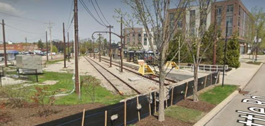
Pullman Standard PCCs “were initially built in the United States by the St Louis Car Company (SLCCo) and Pullman Standard. … The last PCC streetcars built for any North American system were a batch of 25 for the San Francisco Municipal Railway, manufactured by St. Louis and delivered in 1951–2. … A total of 4,586 PCC cars were purchased by United States transit companies: 1,057 by Pullman Standard and 3,534 by St. Louis. Most transit companies purchased one type, but Chicago, Baltimore, Cleveland, and Shaker Heights ordered from both. The Baltimore Transit Co. (BTC) considered the Pullman cars of superior construction and easier to work on. The St. Louis cars had a more aesthetically pleasing design with a more rounded front and rear, compound-curved skirt cut-outs, and other design frills.” [17]

Both the Cities of Cleveland & Shaker Heights purchased PCC trolleys after WWII.  Cleveland operated theirs from 1946 to 1953 before they sold them to the City of Toronto.  Shaker Heights operated their PCCs for a much longer period – i.e. from 1947 up until the early 1980s.” [18]

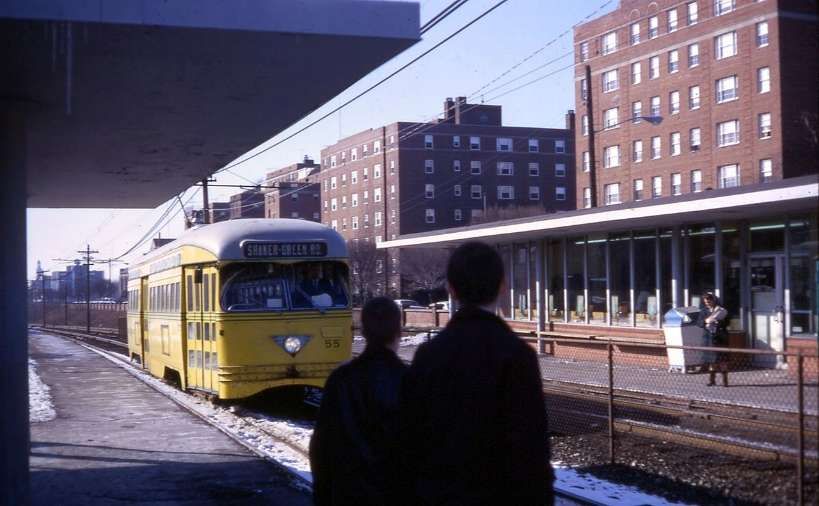
A PCC Streetcar approaching Shaker Square Station, © David Wilson and licensed for reuse under a Creative Commons Licence (CC BY 2.0). [4]

Cleveland’s Breda LRVs are a fleet of 34 vehicles operating on the Blue, Green and Waterfront lines. One is shown below on the Blue Line and one on the Green Line. [19]

Two Breda LRVs on duty on the Blue Line and the Green Line towards the end of the 20th century, © Michael Barera and licenced for reuse under a Creative Commons Licence (CC BY-SA 4.0). [19]

The LRVs were purchased from the Italian firm, Breda Costruzioni Ferroviarie, to replace the aging PCC cars. They were dedicated on 30th October 1981. [3]

The cars consist of two half bodies joined by an articulation section with three bogies. The two end bogies are powered, and the central bogie under the articulation section is unpowered. “The car is slightly more than 24 m (79 ft 10 in) long, is rated AW2 (84 seated passengers and 40 standing), and can travel at a maximum speed of 90 km/hr (55 mph). This speed can be reached in less than 35 sec from a standing start.” [20]

Overall length: 79ft 11in.

Width: 9ft 3in

Tare weight: 84,000lb

Acceleration: 3mph/sec.

Service braking: 4mph/sec.

Emergency braking: 6mph/sec.

Each LRV “is bidirectional with an operator’s cab at either end and three doors per side. The passenger door near the operator’s cab is arranged to allow the operator to control fare collection. The 84 seats are arranged in compliance with the specification requirements. Half the seats face one direction and half the other. Each end of the car is equipped with … an automatic coupler with mechanical, electrical, and pneumatic functions so that the cars can operate in trains of up to four vehicles.” [20]

In 2024, the Greater Cleveland Regional Transit Authority board approved “the selection of Siemens Mobility for a contract to replace the Breda light rail vehicle fleet. … The planned framework contract with Siemens Mobility would cover up to 60 Type S200 LRVs, with a firm order for an initial 24. … The high-floor LRVs will be similar to cars currently used by Calgary Transit, with doors at two heights for high and low level platforms, an infotainment system, ice cutter pantographs, 52 seats, four wheelchair areas and two bicycle racks. … The fleet replacement programme currently has a budget of $393m, including rolling stock, infrastructure modifications, testing, training, field support, spare parts and tools. This is being funded by the Federal Transportation Administration, Ohio Department of Transportation, Northeast Ohio Areawide Co-ordinating Agency and Greater Cleveland RTA.” [21]

References

  1. Shaker Heights Rapid Transit Lines; in Modern Tramway Vol. 12, No 137, May, 1949, p101,102,112.
  2. https://case.edu/ech/articles/s/shaker-heights-rapid-transit, accessed on 1st January 2025.
  3. https://en.m.wikipedia.org/wiki/Blue_Line_(RTA_Rapid_Transit), accessed on 1st January 2025.
  4. https://en.m.wikipedia.org/wiki/Green_Line_(RTA_Rapid_Transit), accessed on 1st January 2025.
  5. https://en.m.wikipedia.org/wiki/Red_Line_(RTA_Rapid_Transit), accessed on 1st January 2025.
  6. https://commons.m.wikimedia.org/wiki/File:Cleveland_Rapid_map.svg, accessed on 1st January 2025.
  7. https://www.loc.gov/resource/hhh.oh0092.photos/?st=brief, accessed on 1st January 2025.
  8. https://www.etsy.com/uk/listing/1213398530/shaker-rapid-shaker-heights-oh-cleveland, accessed on 2nd January 2025.
  9. https://akronrrclub.wordpress.com/tag/shaker-heights-rapid-transit-lines, accessed on 2nd January 2025.
  10. https://www.ebay.co.uk/itm/276745885984?mkcid=16&mkevt=1&mkrid=711-127632-2357-0&ssspo=bTaNd6pwTTu&sssrc=4429486&ssuid=afQhrar7TGK&var=&widget_ver=artemis&media=COPY, accessed on 2nd January 2025.
  11. https://clevelandhistorical.org/items/show/418, accessed on 2nd January 2025.
  12. https://www.riderta.com/dec-17-1913-first-light-rail-service-operates-shaker-heights, accessed on 2nd January 2025.
  13. https://en.m.wikipedia.org/wiki/Tower_City_station, accessed on 2nd January 2025.
  14. https://www.shakersquare.net/history, accessed on 2nd January 2025.
  15. https://clevelandlandmarkspress.com/book_details.php?bid=5#&panel1-5, accessed on 2nd January 2025.
  16. https://hickscarworks.blogspot.com/2013/10/h1218.html?m=1, accessed on 2nd January 2025.
  17. https://en.m.wikipedia.org/wiki/PCC_streetcar, accessed on 3rd January 2025.
  18. https://cs.trains.com/mrr/f/13/t/290183.aspx, accessed on 3rd January 2025.
  19. https://commons.m.wikimedia.org/wiki/Category:Breda_trams/LRVs_in_Cleveland, accessed on 3rd January 2025.
  20. https://www.google.com/url?sa=t&source=web&rct=j&opi=89978449&url=https://onlinepubs.trb.org/Onlinepubs/state-of-the-art/2/2-031.pdf&ved=2ahUKEwinxYDwr9qKAxX0U0EAHWvkKooQFnoECBEQAQ&usg=AOvVaw2t9tHFDwPvUHB1juJqbqWe, accessed on 3rd January 2025.
  21. https://www.railwaygazette.com/light-rail-and-tram/cleveland-light-rail-vehicle-fleet-renewal-approved/64031.article, accessed on 3rd January 2025.