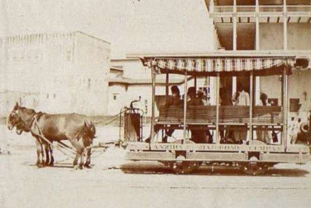
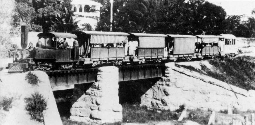
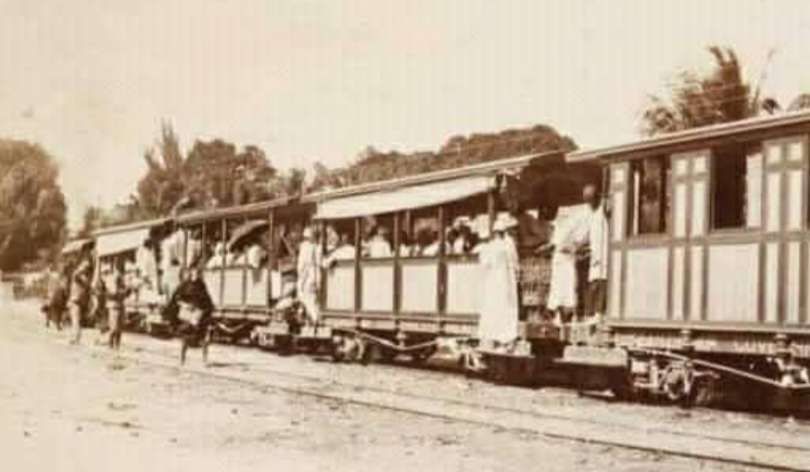
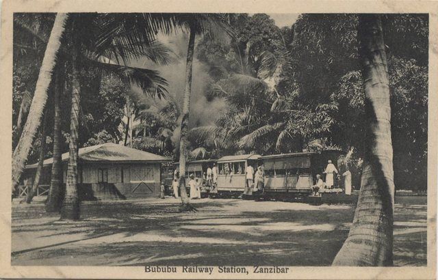
The featured image shows a horse-drawn/mule-drawn tram in Zanzibar before the turn of the 20th century. [1]
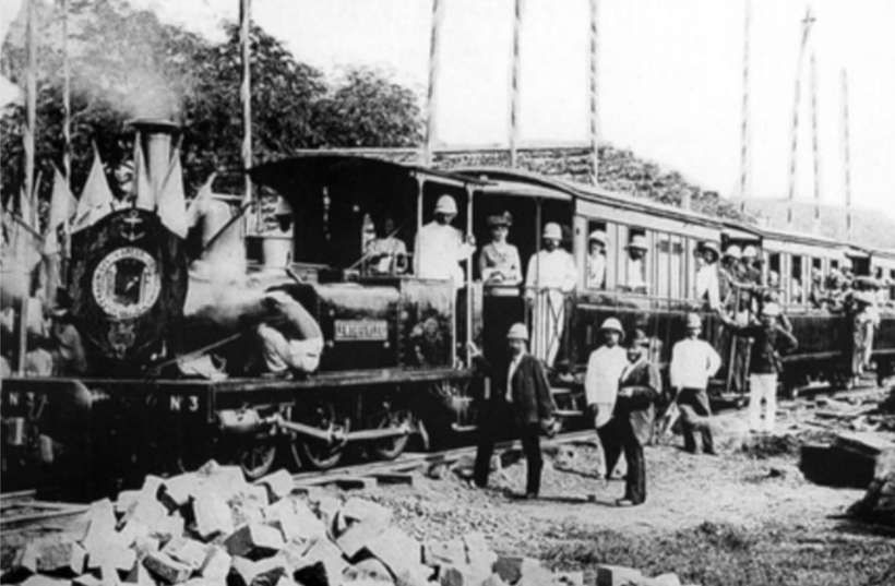
Zanzibar hosted two early rail systems, with a mule-drawn tramway operating from 1879 to 1888 between Stone Town and Chukwani, which later used a steam locomotive. A second, more notable 7-mile line known as the Bububu Railway ran from 1905 to 1930, connecting Stone Town to Bububu, featuring passenger service and, briefly, electric street lighting. [4]
The First Line (1879–1888): Built by Sultan Barghash bin Said, this, one of the first, tracks in sub-Saharan Africa. The 2ft-gauge line ran from the Sultan’s palace at Stone Town [2] to Chukwani. Initially the two coaches were hauled by mules but in 1881 the Sultan ordered an 0-4-0T locomotive from the English locomotive builders Bagnall, this was named ‘Sultanee’. The railway saw service until the Sultan died in 1888 when the track and locomotive were scrapped. [4][11]
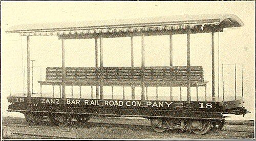
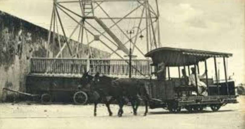
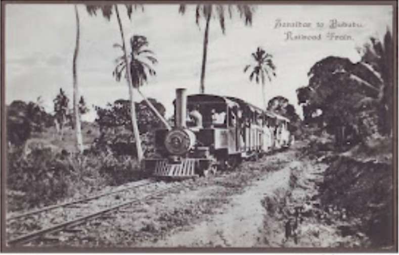
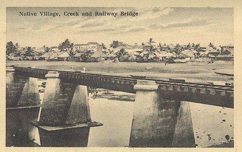
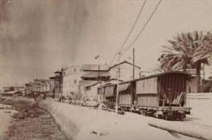
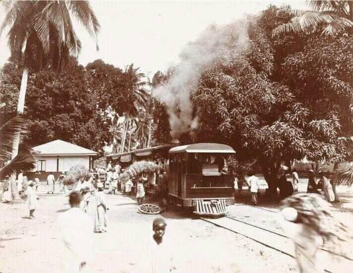
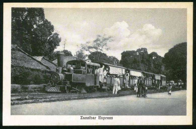
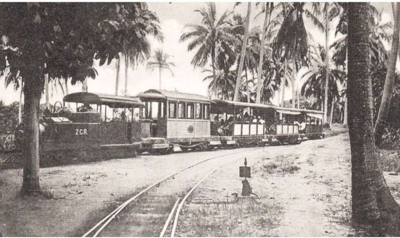
The Bububu Railway – a.k.a. the Zanzibar Railroad Co. (1905–1930) – In 1905, the American company Arnold Cheyney built a seven-mile, 3ft-gauge line from Zanzibar Town to the village of Bububu. It originated near the Arab Fort in Zanzibar Town, ran along the seafront, passed through the city’s narrow streets, and traveled north along the coast to Bububu. It was notorious for its ability to set fire to property and the surrounding countryside, but it ran for 25 years until it closed in 1930. Within the town, the railway operated on some of the narrowest streets. [4][5]
In the 1920s, the trains ran 6 or 7 times daily. The train was popular among the locals, but a special first class coach was available for the benefit of sightseeing tourists. [4]
During the railway construction the Americans undertook the task of installing electrical power lines along the track. Wherever the rails were placed, metal poles were installed and power lines strung overhead. By 1906, Stone Town had electric street lights. In 1911, the railway was sold to the government, and by 1922 the passenger service ceased. As roads improved and motor vehicles on the island increased, its popularity diminished. [4]
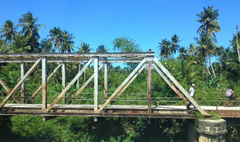
With the improvement works to the port, the railway was used for the haulage of stone which was used to build the port and reclaim the seafront. Today much of the old track bed has been built on however some of the railway’s bridges and embankments remain close to the main road to Bububu. [4]
I have struggled to identify the route of the old railway despite a number of websites/blogs suggesting that remnants of the railway can be seen from the main road to Bububu. The most significant structures may perhaps now be in use by the road or replaced by newer structures carrying the road. I have been unable to locate the structure below, which appears to be seen from the highway:
PastRailwayEmpires identifies this structure as one constructed for the Bububu Railway. The photograph was taken in 2013. Perhaps someone else will be able to identify its location. [12]
Stone Town (also known as Mji Mkongwe (Swahili for ‘old town’), is the old part of Zanzibar City. The newer portion of the city is known as Ng’ambo, Swahili for ‘the other side’. Stone Town is located on the western coast of Unguja, the main island of the Zanzibar Archipelago. Former capital of the Zanzibar Sultanate, and flourishing centre of the spice trade as well as the Indian Ocean slave trade in the 19th century, it retained its importance as the main city of Zanzibar during the period of the British protectorate. When Tanganyika and Zanzibar joined each other to form the United Republic of Tanzania, Zanzibar kept a semi-autonomous status, with Stone Town as its local government seat. [3]
Originally known as ‘The Cranberry and Small Fry Line’, the Edaville Railroad is a 2ft-gauge narrow gauge line in Massachusetts. [1: p555]
It featured in a short article in the August 1952 issue of The Railway Magazine. This is the next article in a series looking at lines featured in early issues of The Railway Magazine.
Writing in 1952, Edwards comments: “Although never exceptionally numerous, lines of this type assisted materially in the development of many areas. As early as 1877, a 2-ft. gauge line, eight miles long, was inaugurated to link the Massachusetts towns of Bedford and Billerica, but the track and plant were removed to the State of Maine two years later, and used for the Sandy River Railroad. This line proved of great service to many previously isolated communities; its development was rapid, and extensions and branches soon brought its mileage up to 120. Other similar projects followed, mostly in Maine, and a sixty-year period of success resulted. In recent years, however, the usefulness of such small lines has declined. The present economic situation has proved an adverse factor … and nearly all of them have been closed.” [1: p555]
He continues: “Nevertheless, one small American line – the Edaville Railroad, of South Carver, Massachusetts seems to have a long and useful life ahead of it. Not only is it a commercially paying proposition, but it performs a special function each Christmas, bringing delight to thousands of children (and their parents).” [1: p555]
The truth is that the line’s history has proven to be much more chequered than Edwards seemed to envisage in the early 1950s. But that is getting ahead of ourselves. There is plenty of space in the rest of this article to look at the later history of the line.
Returning to Edwards article, he says that the line “owes its existence to a plan of … Ellis D. Atwood, who was developing an area of bog as a cranberry plantation. … [By 1952], the Atwood plantations form[ed] the largest privately-owned cranberry plant in the world. A railway enthusiast himself, Mr. Atwood saw in a small-gauge railroad, not only a fulfilment of a life-long ambition to possess his own system, but the very necessary provision of transport for his workpeople and the materials used in his organisation. For instance, 10,000 cu. yd. of sand are used to preserve the bogs during winter, and the narrow-gauge railway solved this problem in a way that probably no other transport could have met, in view of the soft nature of the terrain. Then, of course, the line is fully occupied at harvest time conveying both the fruit and the pickers at a very low cost to its owners. The coaches are also used by the pickers as shelters during the inclement weather often experienced at harvest time; for this they are sited at convenient spots along the line during working hours.” [1: p555]
Edwards says that “In 1939, the 2-ft. gauge Bridgton & Saco River Railroad in Maine almost the last of the [2-ft.] narrow-gauge systems in the United States decided to dispose of its track and rolling stock. This was Atwood’s great opportunity. He bought the plant and rolling stock, and with the purchase of other equipment acquired by collectors from similar small lines passing out of business, the Edaville Railroad (so named by taking its founders initials) was commenced. This search for equipment, and systematic planning and correct siting, took some six years, but in 1946, the railway, complete with facilities for overhauling and repair of rolling stock, stations, auxiliary tracks, and points systems, came into full operation. The stock was four locomotives, eight coaches, six observation cars of the typical American pattern, a parlour car, and numerous trucks for everyday haulage work.” [1: p555-556]
“Thus it was as a utility-hobby that the Edaville Railroad grew. Originally there was no thought of catering for the public, but quite without any prompting from the owners, public interest was aroused.” [1: p556]
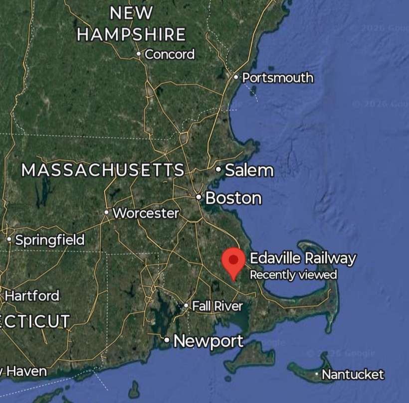
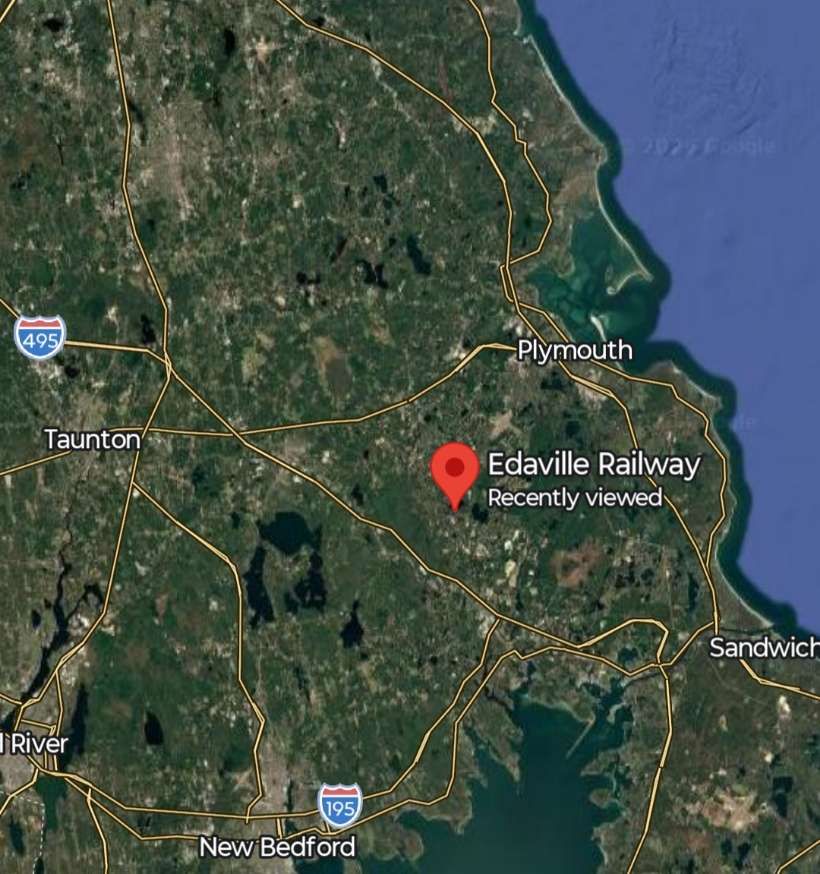
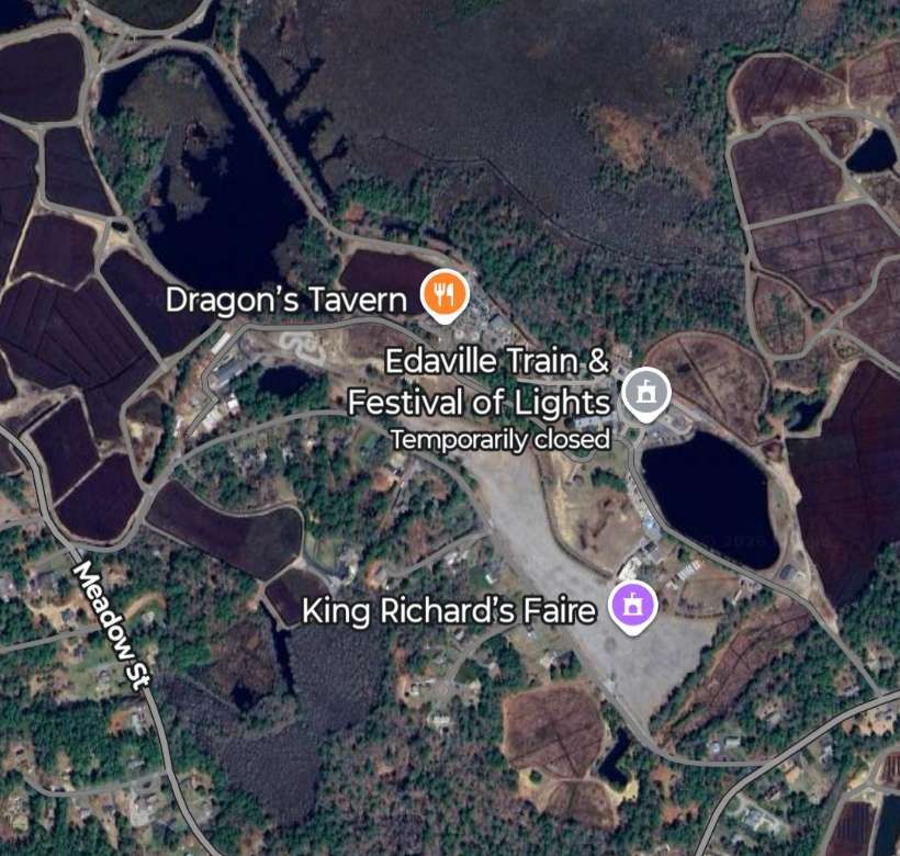
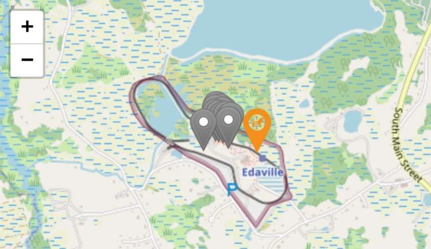
Edaville is located South of Boston, Massachusetts. [Google Maps, January 2026]Magnifying the satellite imagery, Edaville can be seen to be South of the road between Taunton and Plymouth. [Google Maps, January 2026]The Edaville Railroad site is South of Atwood Reservoir, near South Carver. [Google Maps, January 2026]Openstreetmap she’s the location of Edaville. The lake to the North of the site is the Atwood Reservoir. [7]
Wikipedia provides additional detail: “Atwood purchased two locomotives and most of the passenger and freight cars when the Bridgton and Saco River Railroad was dismantled in 1941. After World War II, he acquired two former Monson Railroad locomotives and some surviving cars from the defunct Sandy River and Rangeley Lakes Railroad in Maine. This equipment ran on 2 ft (610 mm) narrow gauge tracks, as opposed to the more common 3 ft (914 mm) narrow gauge in the western United States. Atwood purchased the equipment for use on his 1,800-acre (730 ha) cranberry farm in South Carver. After the 1945 cranberry harvest, Atwood’s employees built 5.5 mi (8.9 km) of track atop the levees around the cranberry bogs. Sand and supplies were hauled in to the bogs, and cranberries were transported to a “screen house” where they were dried and then sent to market. Atwood’s neighbours were enchanted with the diminutive railroad. At first, Atwood offered rides for free. When the demand for rides soared, he charged a nickel a ride. Eventually the line became less of a working railroad and more of a tourist attraction.” [2]
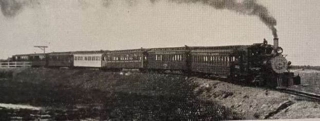
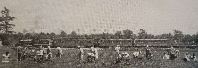
Cranberry pickers at work during the harvest at Edaville with a tourist train beyond. [1: p556]
Edwards says that, “This interest became a clamour, and the Atwood Plantation Company built a station, and opened the line at weekends to passengers, from the spring of each year until harvest time. Throughout the summer, parties from schools, camps, church organisations, and youth groups arrive[d] at Edaville Station for a journey on the last 2-ft. gauge railway in America. While awaiting the trains they [could] visit a railway museum built by the company to house working models of American trains dating back to 1860, and many other interesting railroad relics.” [1: p556]
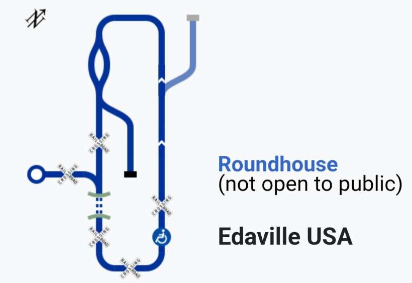
A schematic drawing of the route of the Edaville Railroad in the 21st century. [2]
At Christmas, the Edaville Railroad really came into its own. After harvest, the railway would close until the first week in December when it reopened for what were quite spectacular Christmas excursions. …
Apparently, “12,000 coloured fairy lights [were] used to illuminate the various buildings on the estate, the 300-acre reservoir, the pine forests, and the cranberry bogs on the 5.5-mile journey.” [1: p556] This is all akin to the Santa Specials and the Polar Express experiences offer by many preservation line in the UK in the run up to Christmas.
As of 1952, Edwards says that these sightseeing rides in winter and summer cost young passengers nothing, although as many as a thousand five-cent tickets were sold as souvenirs each day. [1: p556]
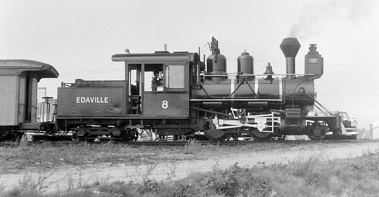
Atwood died in 1950 after an industrial accident. “His widow Elthea and nephew Dave Eldridge carried on operations at Edaville until the railroad was purchased in 1957 by F. Nelson Blount, a railroad enthusiast who had made a fortune in the seafood processing business. The Atwood Estate retained ownership of the land over which the railroad operated, a key point in later years. Blount operated Edaville for the next decade, hauling tourists behind his favorite engine, No 8, and displaying his ever-growing collection of locomotives. Among these was the Boston and Maine Railroad’s Flying Yankee. This helped form the basis for his Steamtown, USA collection, first operating at Keene, New Hampshire, before moving to Bellows Falls, Vermont. (It would later move and be reconstituted as the Steamtown National Historic Site in Scranton, Pennsylvania.)” [2]
Blount was a distant relative of the Atwood family. [6]
Wikipedia continues: “Nelson Blount died in the crash of his light airplane over Labor Day weekend in 1967. Blount’s friend and right-hand man Fred Richardson continued on as general manager until the railroad was sold to George E. Bartholomew, a former Edaville employee, in 1970. … Edaville continued operations for another two decades with Bartholomew at the helm. The railroad operated tourist trains from Memorial Day [through to] Labor Day plus a brief, but spectacular, Festival of Lights in December. …. In the 1980s, Bartholomew’s attention was divided between the narrow gauge Edaville, and the 4 ft 8 1⁄2 in (1,435 mm) standard gauge Bay Colony Railroad he was then forming, running over disused Conrail branch lines. To some observers and former employees, Edaville began to stagnate around this time, although the annual Christmas Festival of Lights continued to draw huge crowds.” [2]
“In the late 1980s, after Mrs. Atwood died and the Atwood Estate evicted Edaville, Bartholomew was forced to cease operations. He eventually put the railroad up for sale in 1991.” [2]
Wikipedia continues: “Edaville ceased operations in January 1992 and much of the equipment was sold to a group in Portland, Maine, led by businessman Phineas T. Sprague. The equipment was to be the basis of the newly formed Maine Narrow Gauge Railroad Museum along the shores of Casco Bay. The sale generated great rancor. Many of the railroad’s employees were not ready to give up on South Carver. Much of the contents of the museum, housed in the former screen house, had been auctioned off the previous fall. But the sale was closed (although the Portland museum took on a debt that would prove all but crushing in subsequent years) and locomotives 3,4 and 8 were trucked to Portland aboard antique trucks loaned for the occasion. Locomotive No. 7, which was owned by Louis Edmonds, left for Maine at a later date.” [2]
Two attempts to revive Edaville during the 1990s foundered. A third attempt in 1999 saw “the new Edaville Railroad opened for operation. Owned and operated by construction company owner Jack Flagg, developer John Delli Priscoli and cranberry grower Douglas Beaton, the railroad acquired a ‘new’ steam locomotive, No. 21 “Anne Elizabeth”, built by the English firm of Hudswell Clarke and a veteran of the Fiji sugar industry. Several of the original Edaville buildings, including the station and the engine house, were demolished with new buildings taking their place. Plans called for the construction of a roundhouse, served by the original turntable, with an enlarged collection of locomotives and rolling stock.” [2]
“By 2005, Edaville Railroad and the land upon which it ran was now owned by a single man, Jon Delli Priscoli. He bought up the Atwood property, bought out partner Jack Flagg, and became the sole owner. Although this removed the railroad/landlord conflict that had plagued Edaville for decades, it proved to be the end of the “old” Edaville. Delli Priscoli turned the land near the milepost known as “Mt. Urann” into a housing subdivision, and pulled up the tracks that ran through the new lots. Late 2005 saw the very last run over the “original line” (pulled by oil-burner No. 21, which had been cosmetically modified to more closely resemble a Maine prototype). When the rails were removed over Mt. Urann, the mainline became a 2-mile (3.2 km) loop, including about half of the line around the old reservoir.” [2]
Wikipedia continues: “In late 2010, the Edaville operators announced that they would not seek to renew their operating lease with Delli Priscoli. Delli Priscoli then put the railroad up for sale for $10 million, and eventually found a potential buyer. However, Priscolli found that the buyer did not intend to continue operating the park, and declined the offer, opting instead to rebuild the park. The restored railroad reopened in September 2011. The following year, the park began a three-year reconstruction project, which includes the installation of additional attractions, refurbishing and repainting existing rides, adding additional parking, and building a new main street entrance and guest services area.” [2]
In the years under Priscoli, Edaville Railroad reopened as Edaville Family Theme Park, an amusement park themed around cranberry harvesting and railroading.
Wikipedia continues: “As of 13th April 2022, Delli Priscoli put Edaville back on the market. The family amusement park [had] closed due to the coronavirus pandemic, and except for the return of the annual Christmas Festival of Lights … has remain closed.” [2]
As of 2025, various options were being explored for re-opening as a more traditional, historic railway attraction. [2] As of January 2026, details of the Christmas Festival of Lights in 2025 can be found here. [6] The then site owners said that “Classic traditions and trains will remain for Edaville’s Christmas Festival of Lights, while a reimagining of the space allows future generations to get to know the joy of Edaville. Long time fans, train enthusiasts, and newcomers can plan to see steam locomotives on trains as much as possible, giving a rare experience as the only operating steam locomotives in Massachusetts!” [7][8]
A significant number of photographs can be found on Tripadvisor. [8]
It remains to be seen whether this attraction survives the next few years and what form it will take. The site was taken over by King Richard ‘s Faire in 2025. [9]
References
Austin Edwards; The Cranberry and Small Fry Line; in The Railway Magazine Volume 98 No. 616; Tothill Press,h London, August 1952, p555-556.
I received a few welcome gifts for Christmas 2025:
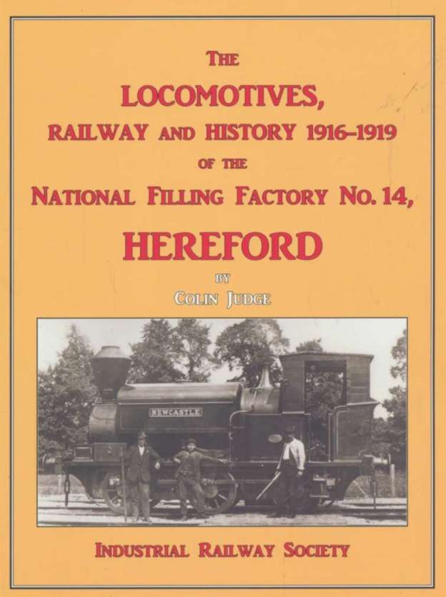
Colin Judge; The Locomotives, Railway and History 1916-1919 of the National Filling Factory No. 14, Hereford; Industrial Railway Society, Melton Mowbray, Leicestershire, 2025. [1]
Anthony Burton; The Locomotive Pioneers: Early Steam Locomotive Development – 1801-1851; Pen and Sword, Barnsley, 2017. [2] The review and notes can be found here. [7]
Christian Wolmar; The Subterranean Railway: How the London Underground was Built and How it Changed the City Forever (2nd extended Edition); Atlantic Books, 2020. This edition includes a chapter on Crossrail. [3]. The review and notes can be found here. [8]
Neil Parkhouse; British Railway History in Colour Volume 6: Cheltenham and the Cotswold Lines; Lightmoor Press, Lydney, Gloucestershire, 2025. [4]
1. The National Filling Factory No. 14 at Rotherwas
I have an abiding interest in the railways of Hereford and so was delighted to receive Colin Judge’s book as a Christmas present.
Judge’s book focusses on an area to the Southeast of Hereford, surrounding Rotherwas House, which was to become an essential element of the British war effort. Initially, intended to be a reserve filling station, National Filling Factory No. 14 was quickly to become vital when on 1st October 1917, the factory at Morecambe was put out of action by an explosion and a major fire. Later, on 1st July 1918, an explosion at the Filling Factory at Chilwell killed 134 employees, leaving it only able to produce munitions at a much reduced level. No. 14 was critical to the supply of munitions.
The usage of shells during the conflict was frighteningly high, staggering! Judge tells us that during the Battle of the Somme 1,738,000 shells were used, and that at Passchendaele, over 5 million shells were fired. It is difficult to appreciate what those on the battlefield experienced. [1: p4]
This rate of usage demanded an unbelievable level of activity on the home front. 507 acres were purchased for the new factory around Rotherwas House. “The order was then given on the 30th May 1916 to commence the drawings and these were started on the 1st June 1916. The set of drawings for the Amatol section of the factory was finished and sent out to tender on the 12th of June. … Then the remaining drawings, of the Lyddite/Picric area were finished on the 15th of June and again dispatched to the various tenderers … construction [commenced as soon as] the final contractor was chosen.” [1: p15] John Mowlem & Co. Ltd won the contract on the basis of a guaranteed lump sum of £1,200,000 (approx £133,392,000 in 2025!).
Remarkably, in an incredible feat, 3,000 drawings covering the factory and an outpost at Credenhill (an ammunition storage facility) were produced in just a fortnight! All drawn by hand! Even more incredible when a significant design change occurred increasing the required output from the factory from 400 tons of Amatol and 200 tons of Lyddite per week. The new demand was for 700 tons of Amatol and 400 tons of Lyddite each week!
The contract for the construction was signed by both parties on 5th July 1916. Work progressed at speed and the first shell was being filled in the Lyddite area on 11th November 1916. The Amatol side of the factory filled its first shell on 22nd June 1917.
Judge tells us that Mowlem had to assemble the Amatol and Lyddite areas, a huge army ordnance depot (Rotherwas stores), barracks for the guards (alterations to Rotherwas House), hostel accommodation in Hereford for construction workers, stores and barracks at the Credenhill site (6 miles further from Hereford and on the Midland line from Hereford to Hay and Brecon). [1: p18]
The story of the works is copiously illustrated with contemporary plans and photographs and a modern diagrammatic representation of the internal railway system at the factory site. There were more than 27 miles of internal standard-gauge railways! [1: p16-17][5] In addition, the Picric/Lyddite area of the works was served by a significant network of 2ft-gauge lines. [1: p16]
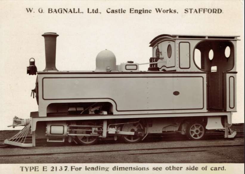
In addition to covering the history of the site during World War 1, Judge describes the fleet of 2ft-gauge locomotives known to be used by John Mowlem &Co Ltd during construction of the site. These included: Kerr Stuart Wren Locomotives, KS2473, KS2474 and KS2477, all built in 1916; and Bagnall works number WB1740. Other locomotives may also have been used during construction: KS1047, KS1142, KS1144, KS 4017, KS 4018.
Judge provides drawings of the Kerr Stuart Wren Class of locomotives [1: p10 & 11] and details/photographs of the Bagnall Locomotive, works No. WB1740. [1: p11-14]
Judge provides notes on the locomotives used at Credenhill [1: p54-63] and at the Rotherwas Site. [1: p77-92] He also includes a chapter which is well-illustrated, focussing on the employees and the operation of the Rotherwas Site.
Chapters headings in Judge’s book are:
Chapter One: Brief History of the Proposed Area for the National Filling Factory No. 14, Hereford.
Chapter Two: Why did Britain need a new National Shell Filling Factory?
Chapter Three: Ministry of Munitions purchase of the land for the National Filling Factory No. 14, Hereford.
Chapter Four: John Mowlem Ltd – the Contractor and his Locomotives used on this site.
Chapter Five: Construction of the National Filling Factory No. 14, Hereford.
Chapter Six: The Great Western Railway, London & North Western Railway and Midland Railway’s involvement in the Factory’s Construction and Operation.
Chapter Seven: Credenhill – Army Ordnance Depot – the NFF Hereford’s Outpost
Chapter Nine: Basic Operations at the Hereford No. 14 Factory, Rotherwas.
Chapter Ten: Details of the Locomotives known to have operated on the internal railway at Hereford No. 14 (Rotherwas) Factory site.
He also includes as an Appendix, a short history of the site throughout the 20th century.
Rotherwas was revived as a Royal Ordnance Factory (Filling Factory No 4) with the onset of the Second World War in 1939, and filled large bombs and 15 inch (38 mm) shells for naval guns. [6]
References
Colin Judge; The Locomotives, Railway and History 1916-1919 of the National Filling Factory No. 14, Hereford; Industrial Railway Society, Melton Mowbray, Leicestershire, 2025.
Anthony Burton; The Locomotive Pioneers: Early Steam Locomotive Development – 1801-1851; Pen and Sword, Barnsley, 2017.
Christian Wolmar; The Subterranean Railway: How the London Underground was Built and How it Changed the City Forever (2nd extended Edition); Atlantic Books, 2020. This edition includes a chapter on Crossrail. [8]
Neil Parkhouse; British Railway History in Colour Volume 6: Cheltenham and the Cotswold Lines; Lightmoor Press, Lydney, Gloucestershire, 2025.
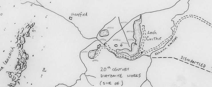
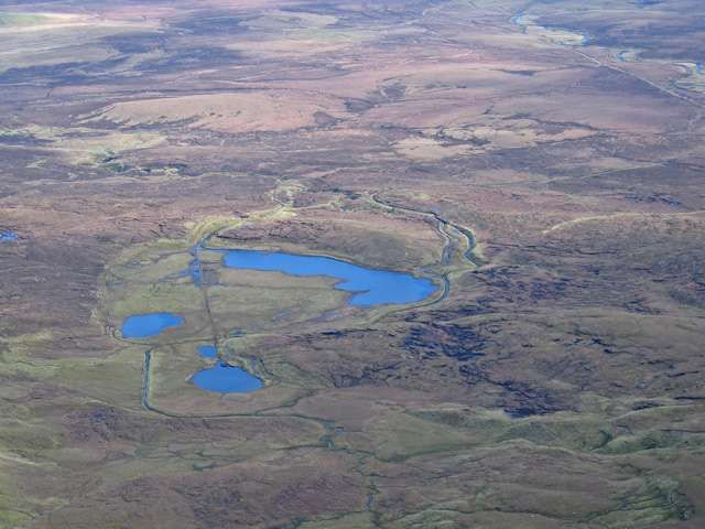
Derived from the remains of microscopic fossilized sea or freshwater algaes, diatomite is a naturally occurring, versatile mineral used in an array of applications from cosmetics to filtration. [4] It was harvested by drag line from Loch Cuithir in the late 19th century and the first half of the 20th century.
“This unique form of silica has an elaborate honeycomb structure, peppered with thousands of tiny holes ranging from a few microns to submicron diameters. No other silica source, be it mined or artificially produced, presents such a structure. Some diatomite deposits are saltwater but most are from freshwater sources. … When ground, this profusion of shapes results in an extremely low-density powder known as ‘diatomaceous earth’ (DE) which has excellent absorption properties that are highly prized for filtration, agriculture, paints, plastics, cosmetics, and pharmaceuticals application.” [4]
Diatomite was also used in the production of dynamite. [2][3]
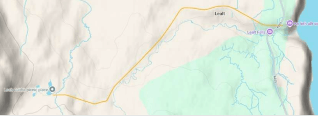
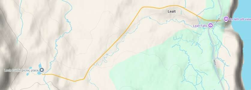
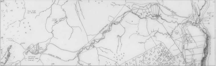
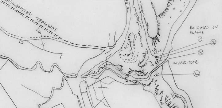
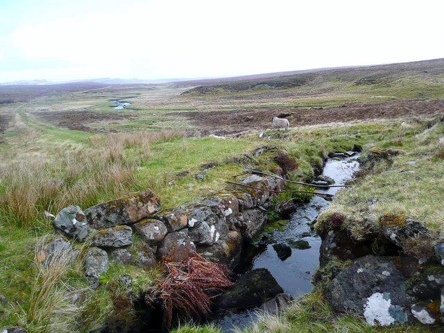
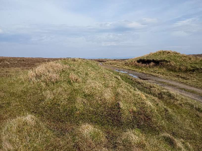
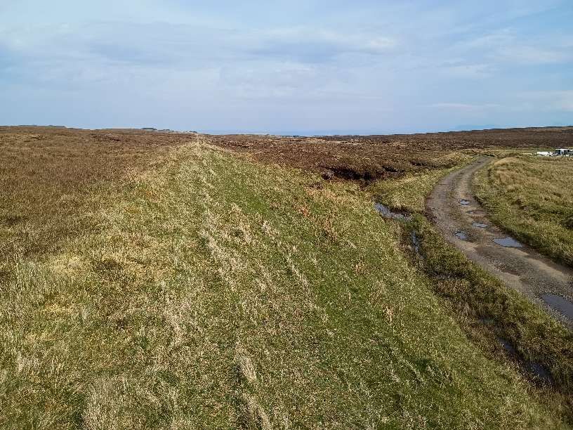
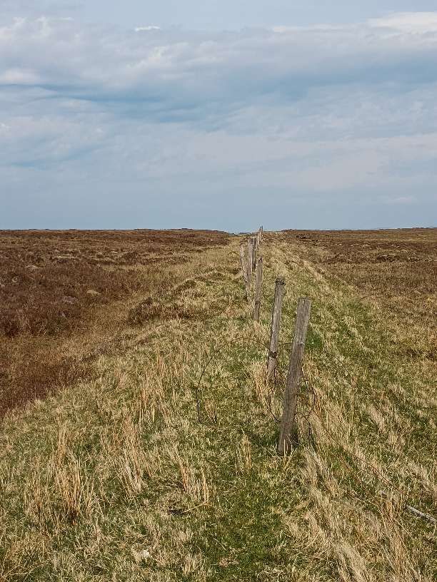
Possibly as early as 1885 [1] but certainly by 1889, [2][3] work was underway at this site. A 2ft [2][3] or 2ft 6in [1] gauge tramway was being constructed in 1889 from the drag-line at Loch Cuithir to Lealt. The tramway followed the River Lealt down to its mouth at Invertote. When first opened the line was worked by gravity and manpower. Apparently, later in the life of the line a small steam locomotive was in use. [2][3]
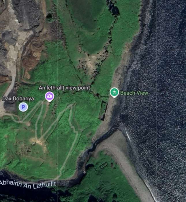
At the “Western end of the line … at Loch Cuithir, … diatomite – known locally as Cailc (Scottish Gaelic for chalk) – was taken out from the loch bed and dried on wire nets. The seaward terminus had warehouses on the cliff-top at Invertote. At the base of the cliff was a factory where the diatomite was kiln dried, ground and calcined. [A] line … extended from the factory onto a pier into the Sound of Raasay.” [2][3]
Diatomite was also gotten from Loch Valerain and transported by aerial ropeway to Staffin Bay and on along the coast to Invertote Apparently, “during its existence, the Skye Diatomite Company extracted 2000 tons of diatomite. … From Invertote, the diatomite was transferred by skiff, onto puffer boats, waiting in the bay, and shipped across to the mainland. The diatomite was turned into kieselguhr which was mixed with nitroglycerine by Nobel Industries, at Ardeer, to make dynamite.” [2][3]
Stornoway Gazette described the operation as follows:
“Over the years, the mine saw periods of inactivity, but when up and running operations made use of the large industrial works at the area – a large factory building, a railway with embankment cuttings, and a rolling stock traversing three miles of landscape, including an aerial ropeway. The light railway was used to transport the Loch Culthir Diatomite to the shores at Invertote for a final drying and grinding, and a large building containing a furnace, grinding machine and storage space was constructed there for this purpose. Such modernised business works were quite remarkable for this part of the world at the time. In those days there was no road between Staffin and Portree, so a puffer boat would anchor in the bay at Lealt, and local skiffs were used to transport the finished Diatomite from shore to boat, ready for shipping to the mainland. There were around 40 to 50 people steadily employed at Lealt, yet on days that the boat came in this total rose to as many as 80 workers.” [7]
“Perhaps one of the most intriguing aspects of the mine’s history comes from the ownership of the drying factory at Invertote by Germans. Although closed during the period of the Great War, surprisingly the now enemy foreign residents were allowed to stay on. Shortly afterwards a rumour began to circulate that the area was haunted and that the ghost of a recent tragic death at the Lealt falls had appeared at the factory. As the local story goes, (the rumour was actually started by the Germans) with the intent of keeping locals away. It turned out that the resident Germans were spies and that, almost unbelievable to the community, the area was being used as a German base with submarines surfacing in the sea bay!” [7]
“Moving on, the year 1950 saw the next development in the mining of Diatomite from Loch Cuithir. As the loch was one and a half miles up the moor, through peat bogs and rivers, the Department of Agriculture and Fisheries for Scotland (DAFS) decided that a road should be built, with the intention of extracting the Diatomite by digger, and then taking it to the Lealt road end above Invertote. The road took around a year and a half to build, during which the mine was put out of operation. Yet, when production started again, the new method of extraction did not reach the high standard of quality which was achieved when extracted manually by spades. The mechanical extraction resulted in the Diatomite being less pure, and full of unwanted dirt. Drying the substance is, in fact, the problem of the process, for it is obvious that in a damp climate like Skye, the diatomite does not lose its moisture quickly. The problems which began after the construction of the 1950s road were further highlighted and compounded six years later. A new factory was built at Uig (the site where the Cal Mac offices are now situated), far from the mining site at Loch Cuithir, and it may be said that this move was the ruining of the entire Diatomite industry upon Skye. As Diatomite was no longer dried at Invertote it now had to be transported by road, wet, for the much-needed drying process to Uig, 23 miles away. A vehicle may have left Loch Cuithir carrying five tonnes of Diatomite, yet only producing one tonne of the finished product after drying had taken place – a finished product which was also not as pure as it ought to be for the specialised work it had to do in various products. A lot of money was wasted on travelling, and within the factory itself, inefficiency was also present, with machinery often breaking down due to the damp state of the Diatomite. Outside the factory, the scenic communities of Trotternish also began to suffer. When the factory was working, it poured out a fine white dust which covered every house in the area. Grass became chalky in colour and after dry spells in the weather, the road-sides from Staffin to Uig would turn white with Diatomite – Uig was constantly under a cloud of dust. With complaints of insubstantial profits and bad management, the factory was finally closed to production for the last time in 1960. Yet, although the Diatomite mining industry on Skye came to an abrupt ending, it was still regarded by many locals as a blessing at the time. Following from World War One, the industrial works provided employment for many returning men who could not find work elsewhere in the island. And at peak production, around 1955/56, 50 to 60 men were paid good wages to work at the factory.” [7]
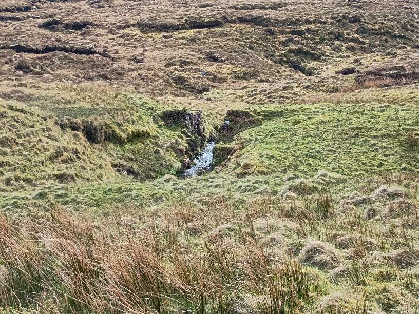
Bell & Harris tell us that “Loch Cuithir is located upon landslipped material, which overlies Upper Jurassic strata. Only parts of these diatomite workings remain. Some of the brick buildings, together with the line of the tramway used to transport the diatomite to the coast, are still obvious. The diatomite occurred as a 3–6m-thick horizon below a 1m covering of peat. The loch had an original area of 60 hectares (24 acres) and was drained in order to extract the diatomite. Ditches, around the perimeter of the loch, were excavated and the water was drained through a man-made outlet at the northern end of the loch, thus allowing removal of the peat and extraction of the diatomite. East of the drainage outlet are spoil-heaps, mostly of plateau lava boulders, presumably removed from the workings during excavation. The diatomite from this deposit was very pure, with little or no interlayered silt or mud. Macadam (1920) notes that the calcined (heat treated) diatomite contains over 96% [Silicon Dioxide](reported in Anderson and Dunham 1966), whilst Strahan et al. (1917) gave a value of 98.78%. According to Macadam (1920), the absorptive value of the material from Loch Cuithir was over 3.56 (a good diatomite would have an absorptive value in excess of 4.0).“
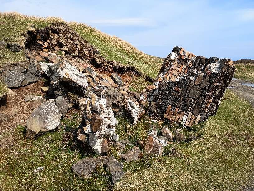
Some excellent photographs of the derelict factory at Invertote can be seen here. [8]
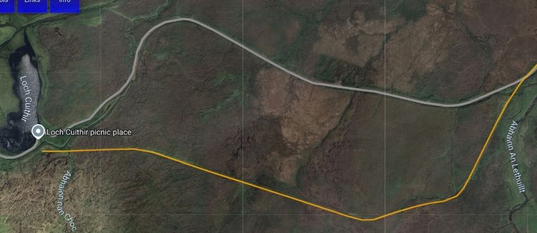
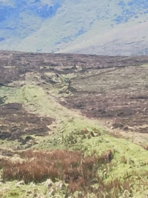
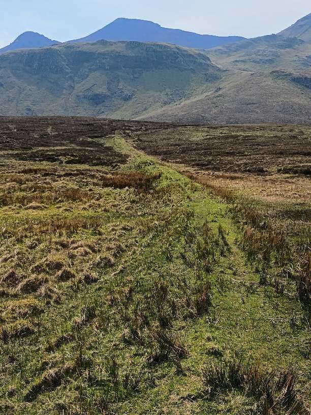
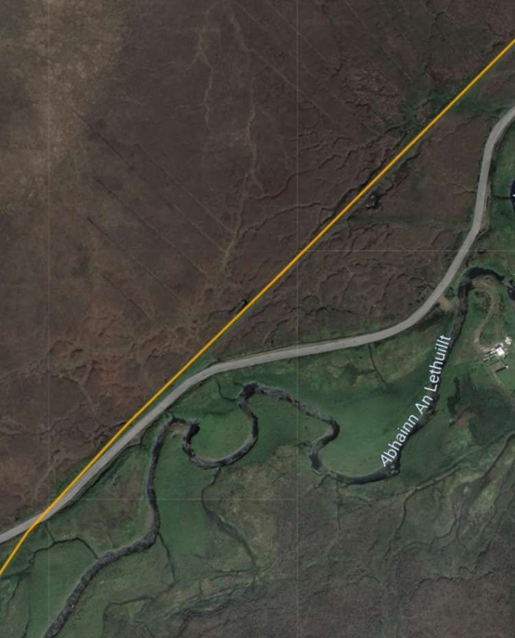
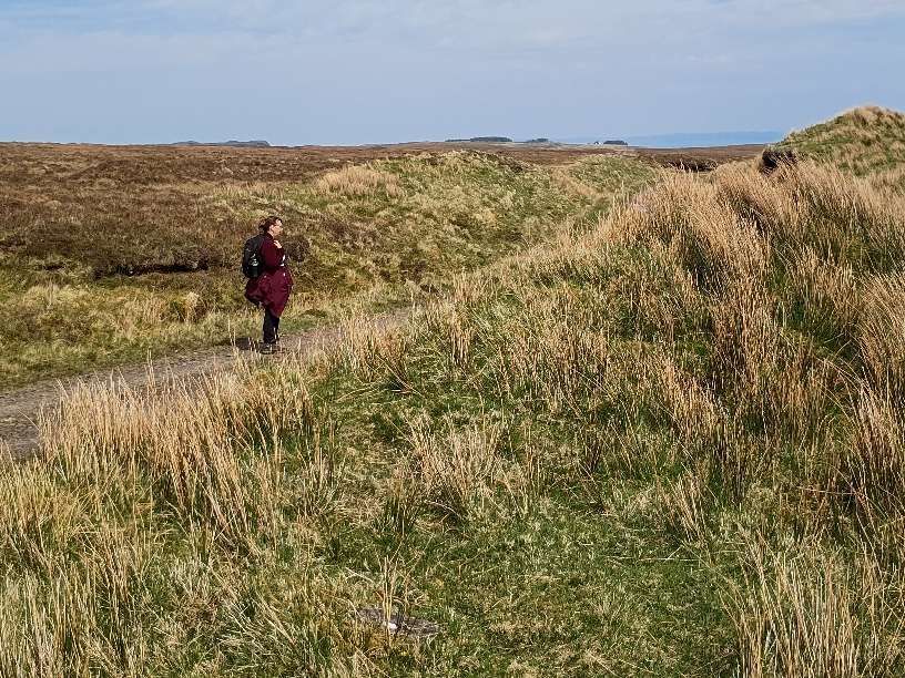
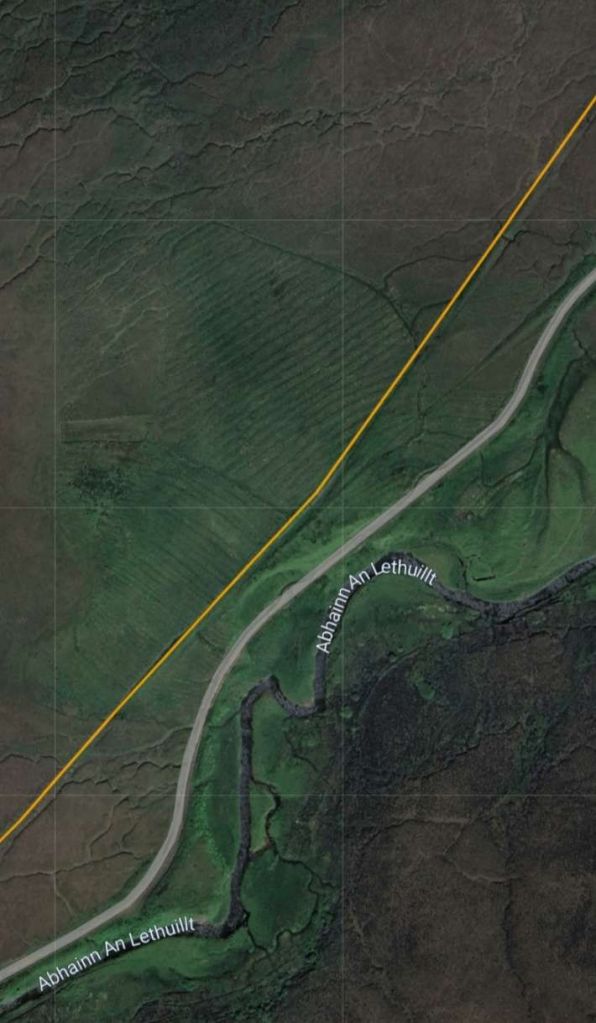
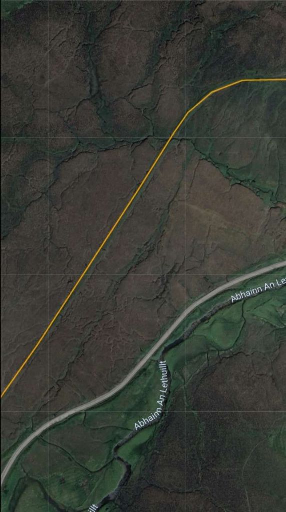
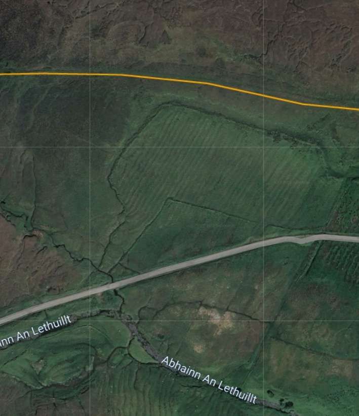
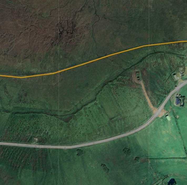
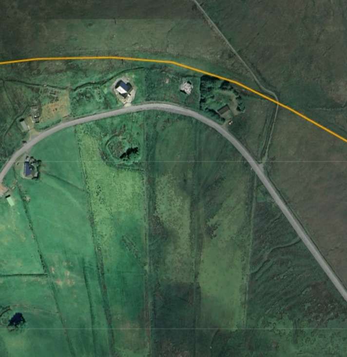
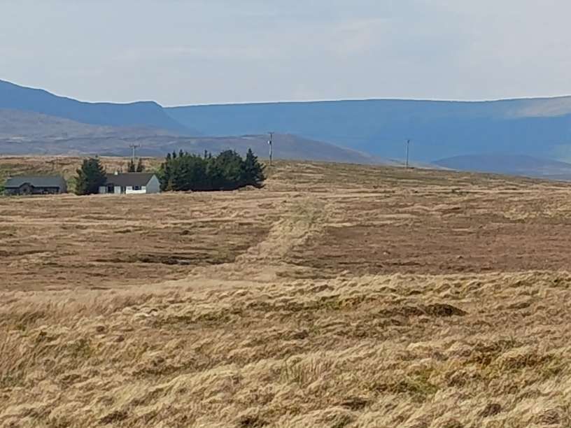
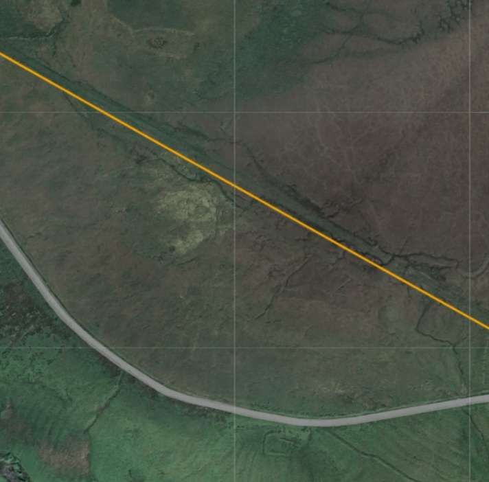
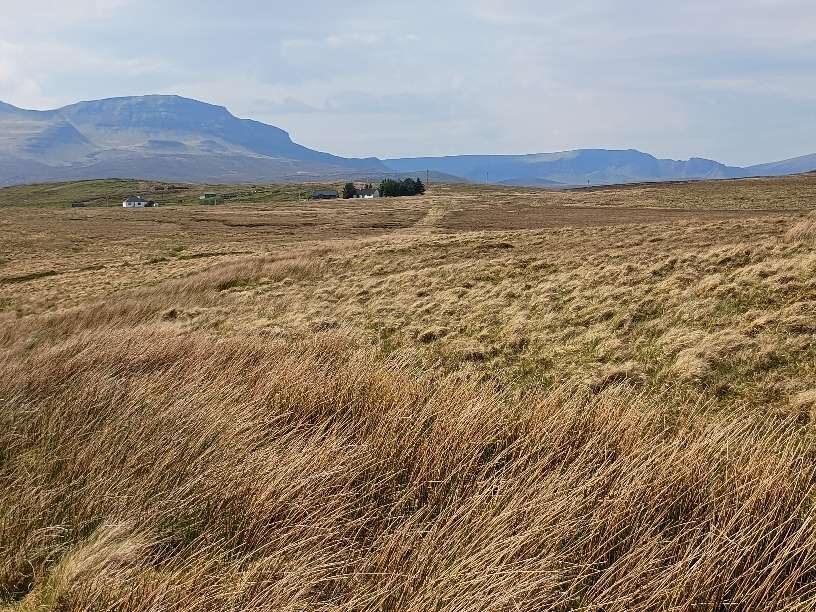
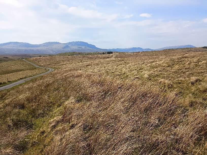
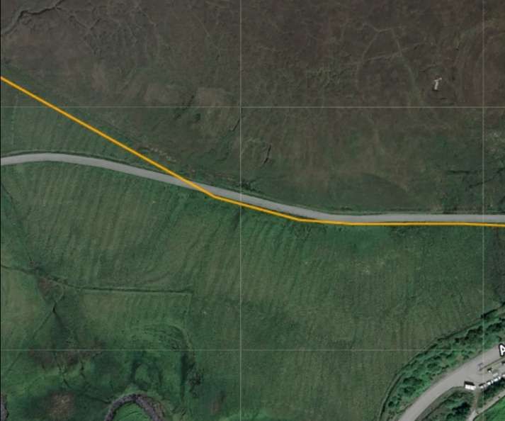
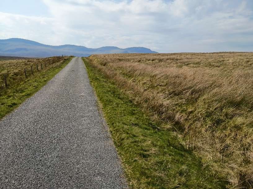
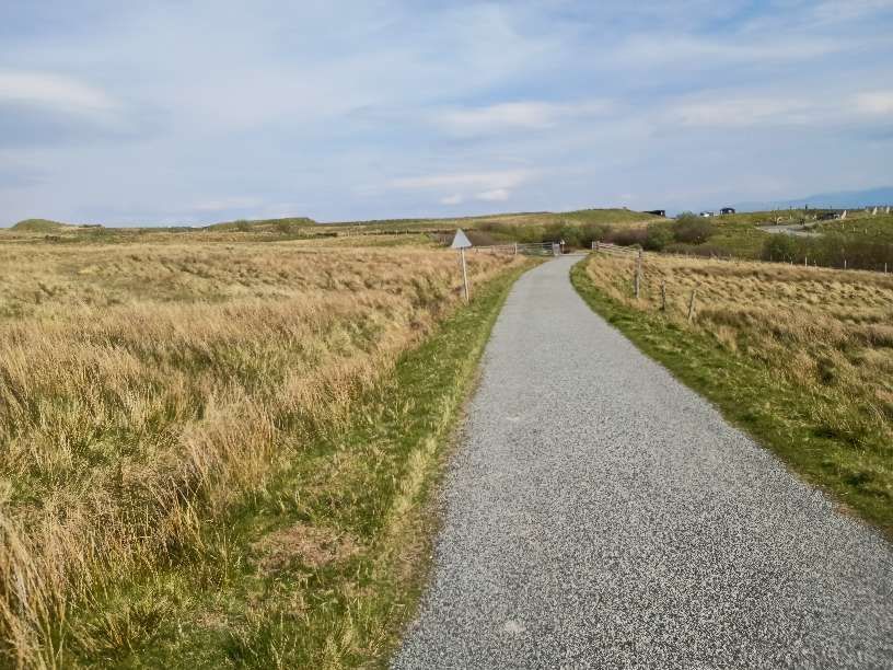
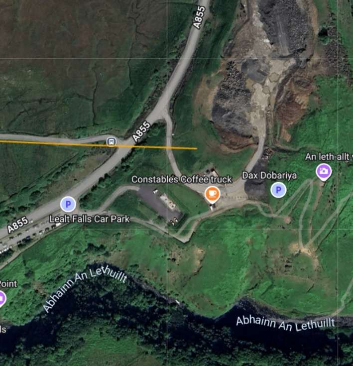
The Route of the Tramway/Railway
From Loch Cuithir, the railway ran in a Southeasterly direction over boggy ground. Minimal earthworks were undertaken placing the railway at a level just above surrounding ground.
The Canmore National Record of the Historic Environment profiles these notes:
“One of the greatest causes of interest in Skye Diatomite was its potential use as a substitute for Kieselghur by Alfred Nobel in the production of Dynamite in Nobel’s new Scottish factory at Ardeer in Ayrshire during the 1880s. Nobel eventually found a better source of material, but the Extraction of Diatomite nevertheless began in Skye at Loch Cuithir in 1886. The Diatomite was transported by tramway to be processed at Invertote, production continuing until 1913. The industry was briefly revived between 1950 and 1961, using road transport.” [13]
“The principal remains of the Invertote works are a large, rubble-built, rectangular-plan roofless building (NG5201 6049). It has been entirely gutted, but fragmentary remains include a large cast-iron flywheel from a steam engine, and a cast-iron wall-mounted bearing box. The other surviving structure is a kiln (NG5201 6052), comprising a lower chanber or firebox built from Scottish firebricks (produced at the Star Works, Glenboig, Lanarkshire, and Etna Works, Armadale, West Lothian), onto which has been constructed a circular-section fireclay-brick column encased by an outer layer of sheet steel. The exact functions of the processing building and the kiln are uncertain, but it is likely that the latter was used for drying purposes.” [13]


