Category Archives: Railways and Tramways Blog

Nice to Digne-les-Bains Part 15 – Locomotives and Rolling Stock – Steam (Chemins de Fer de Provence 79)

This post focusses on the Steam locomotives used on the line between Nice and Digne-le-Bains. It is unlikely to be comprehensive and I’d be grateful of any contributions by others which will add to my knowledge. I am hampered particularly by not having access to the seminal work on the network by Jose Banaudo, “Le Siecle du Train des Pignes.” [25] The text of this book is in french and as it is out of print a good copy will cost well over 50 euros. If anyone has access to this book and is prepared to add to the text of the blog, please feel free to do so, or email me direct and I will update the post.

I would be particularly interested in details of locomotives which ran on the Nice to Digne Line throughout its life and which are nor properly covered within the text below.

As part of studies on the two other main-lines which made up the network of the Chemins de Fer du Sud de la France – the Central Var line and Le Macaron – we covered a lot of ground investigating early traction and steam power on the lines of the whole network and provided as much information as possible about rolling stock on the system.

The relevant posts are:

Locomotives and Rolling Stock on the Central Var Line (Chemins de Fer de Provence 50)

Locomotives and Rolling Stock on the Central Var Line (Chemins de Fer de Provence 52)

Rolling Stock on the Central Var Line (Chemins de Fer de Provence 54)

Ligne du Littoral (Toulon to St. Raphael) – Part 14 – Locomotives and Rolling Stock (Chemins de Fer de Provence 49)

These posts are as comprehensive as possible for the era of operation of those lines and cover the period up to their closure after the Second World War. However, they are focussed on the two lines which closed. It make sense, therefore to review those posts in the light of a focus on the Nice to Digne Line. This blog sets out to do just that. I need also to acknowledge the support I have received in collating this information from Etienne de Maurepas (Étienne Thilliez). [12]

Steam Locomotives on the Nice to Digne Line

Background information on the companies which built the steam locomotives which served on the Central Var line can be found by reading my post on the locomotives of the Coastal Line  – Le Macaron. [1]

At the height of its powers, between 1888 and 1908, Le Chemins de Fer du Sud de la France network had:

• 23 steam locomotives.
• 42 passenger coaches: 3 in 1st class A series; 21 mixed 1st and 2nd class series AB; 6 in 2nd class B series; 2 mixed 2nd class + van series BD and 10 open coaches called ‘jardiniers’ series AC and C. These were sourced from various manufacturers: the Foundries and Forges of Horme Company, Chantiers de la Buire in Lyon; the Desouche and David workshops in Pantin; the Hanquet factories -Aufort and Company in Vierzon; the establishments De Dietrich in Lunéville; and the ‘jardiniers’ came from a network of steam trams – the Raincy-Montfermeil in the northern suburbs of Paris.
• 12 luggage and post office vans: 10 luggage vans with DD series postal compartment and 2 DS series emergency vans. Their manufacturers were as follows: 6 Buire vans, 4 De Dietrich vans, 2 Hanquet-Aufort vans.
• 219 goods wagons: built by Horme and Buire, Hanquet-Aufort, De Dietrich, and Magnard and Decauville.

Between 1889 and 1894, 19 steam locomotives were put into circulation on the whole network; divided between 3 manufacturers: 8 SACM, 8 Pinguely and 3 Corpet-Louvet.[2] A number of these were used on the Nice to Digne line.

Between 1889 and 1894, 19 steam locomotives were put into circulation on the whole network; divided between 3 manufacturers: 8 SACM, 8 Pinguely and 3 Corpet-Louvet.[5] A number of these were used on the Central Var line.

Later, other locomotives were purchased …..These Locomotives included some from the manufacturer Franco-Belge as well as SFCM, SACM, Pinguely and Corpet-Louvet.

In the first decade of the 20th Century, Pinguely 4-6-0T locomotives were ordered. The close-up shot shown below is taken at Toulon, but these locomotives also served on the Nice to Digne Line.
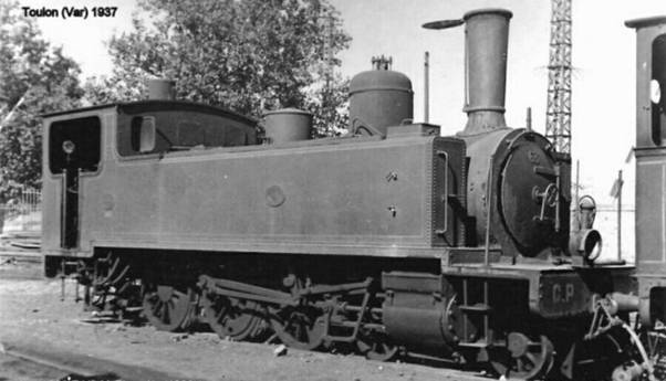
Very similar 4-6-0T locomotives were ordered from SACM. The image below is one used on the Macaron but it is identical in design to ones used on the Nice to Digne line.
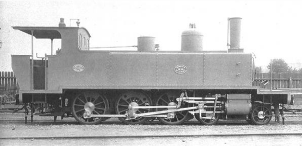
Details of these locomotives and pictures of them operating on the Nice to Digne line can be found below.

1. Pinguely, SFCM and SACM 4-6-0T Locomotives

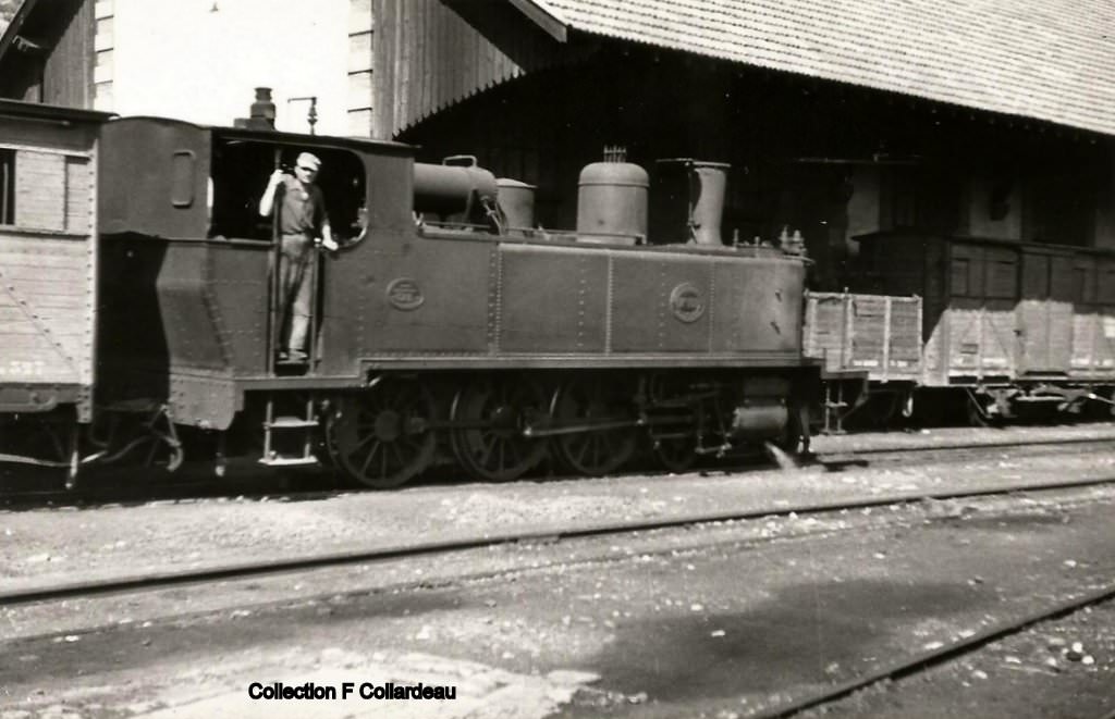
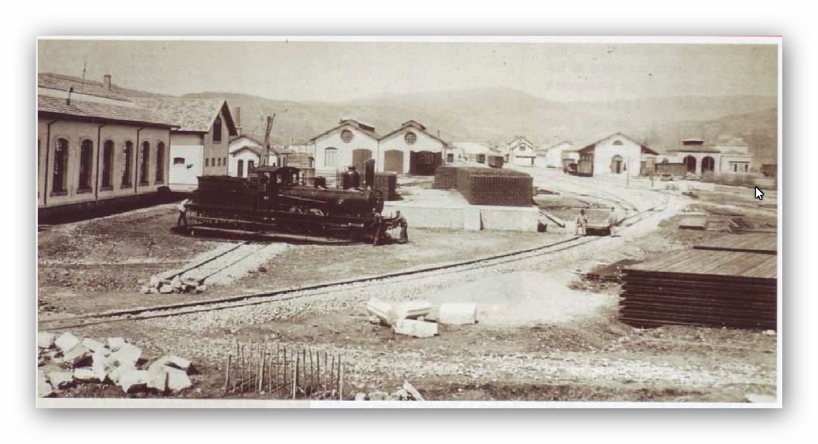
Locomotive No. 89 is a 4-6-0T Pinguely (Works No. 192) delivered in November 1905 and remodelled in 1949 (see picture below). Sérié E of Les Chemins de Fer du Sud de la France, it is part of a series of 12 locomotives delivered between August 1905 and December 1907. The whole network including the coastal line had a total of 28 E and F Series 4-6-0T locomotives, supplied by several manufacturers. No. 89 was scrapped in January 1951. According to José Banaudo, these 4-6-0T locomotives were the best steam engines on the network.
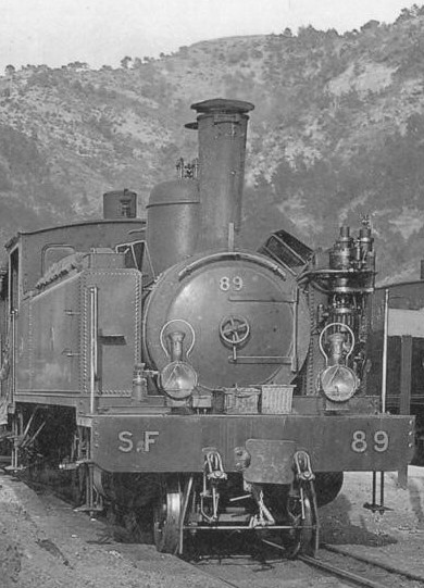
The picture of SF No. 89 was taken at La Manda Station on the Nice to Digne line. This is the best head-on picture of a Pinguely 4-6-0T engine that I have discovered.

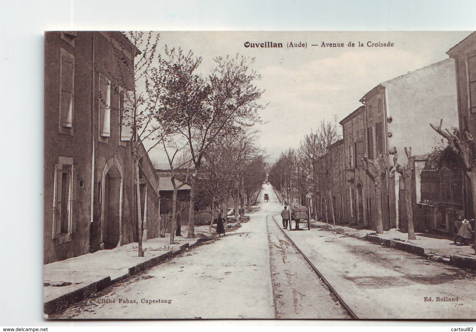
It is difficult to distinguish between the different 4-6-0T locomotives on many of the postcard images available today. For example, there are two images of the La Manda Station near Colomars below. In the first image it appears that the locomotive is a 4-6-0T but the resolution of the image is not good enough to determine whether it was made by Pinguely or SACM. The second image appears in Jose Banaudo’s book [3] and on the CPArama website. [4] Banaudo highlights the fact that the locomotive in that image is a 4-6-0T but does not clarify which manufacturer. He does draw attention to the flat wagon at the left of the picture which he says must have come off the TAM network because of its narrower loading gauge.I have been consulting with 242T66 on “Les Passions Metrique et Etoile!!” Forum [9][12] about some of the photographs in this blog. They comment that it is likely that the locomotive in the second image is an type E 4-6-0T because the type F had an air-compressor fitted to the right-hand side of the smokebox. It is possible that the locomotive is a SACM Series 81-86 rather than a Pinguely locomotive.
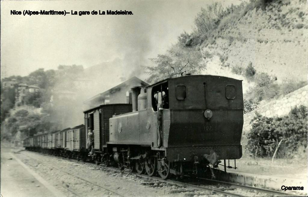
NICE (AM) – Locomotive No. 102 tows freight train at La Madeleine station – Photo Card. 
The locomotive No. 102, type 4-6-0T, was built in 1908 by the French Society of Mechanical Engineering (SFCM) – Cail in Denain (North). It was delivered on July 6, 1911 to the Railways of Provence – It was part of the series Nos.101 to 105 – After a career of more than 40 years, having traveled 752,362 km. this loco was stabled in 1952 and scrapped on 24th March 1954. [3][10]
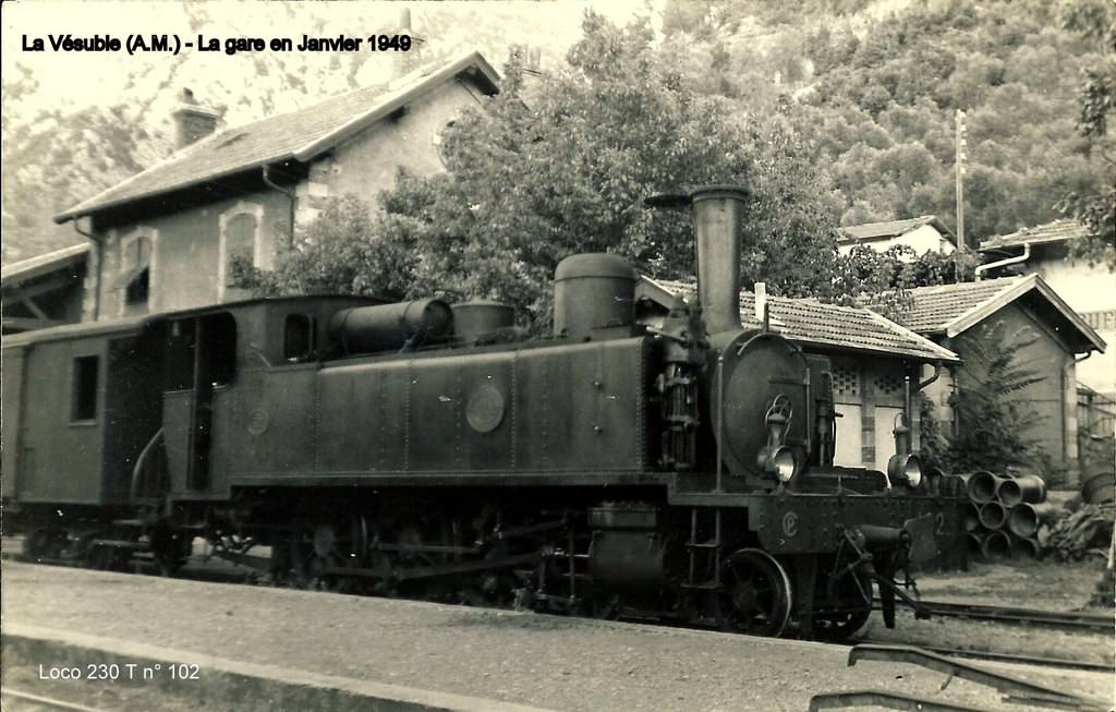
Another view of the 4-6-0T locomotive No. 102, at the station of La Vésubie in January 1949 – Photo card. (Bernard Roze collection). [10]
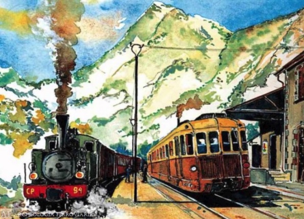
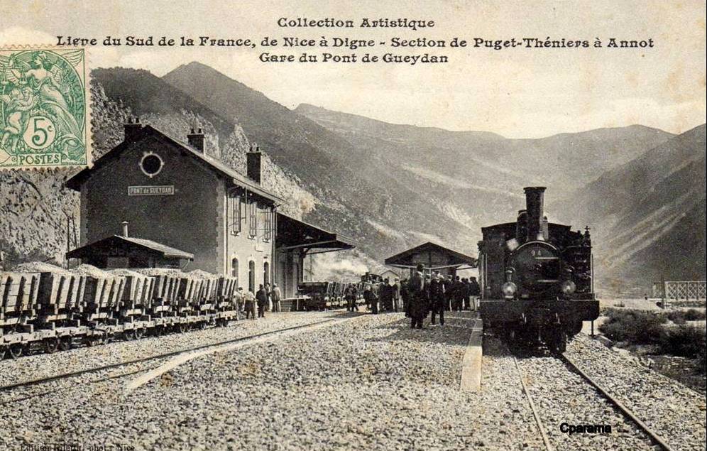
This picture shows the official reception train headed by 4-6-0T Pinguely No. 94 on 30th September 1907, the trucks on the left belong to the contractor, Entreprise Orizet. The station is La Gare du Pont de Gueydan. [3][5][12]
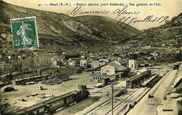
In this view, taken sometime between 1908 and 1911 .an unidentified 4-6-0T (I think) approaches Annot Station from Nice. At this time the middle section of the line between Annot and Saint-Andre-des-Alpes was still under construction. [3][7]
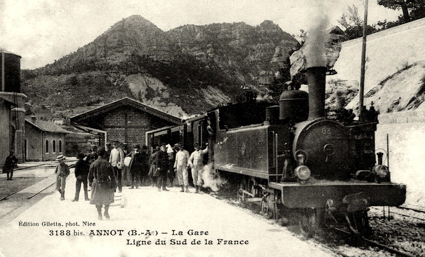
A train for Nice headed by 4-6-0T SACM No. 83 at Annot Station. [3][12]
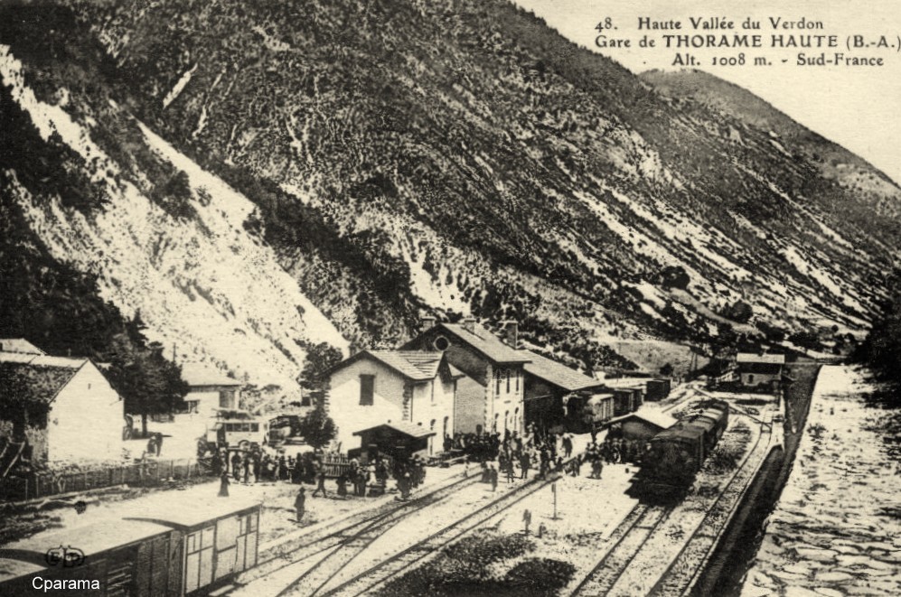
What appears to be a 4-6-0T locomotive stands at Thorame-Haute. The picture is not clear enough to identify the locomotive. [6][12]
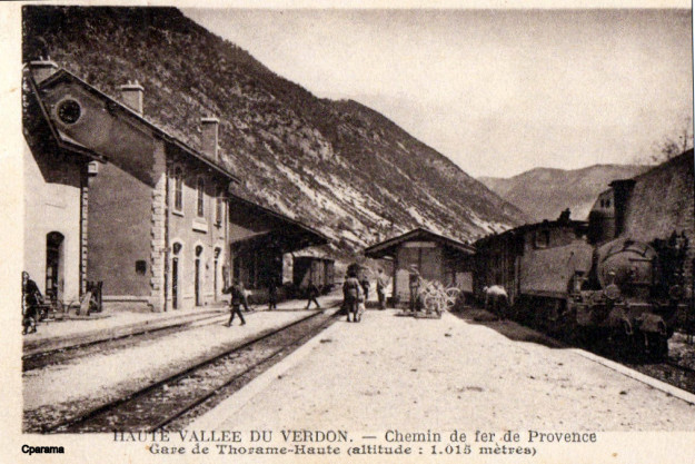
An unidentified 4-6-0T also standing at Thorame-Haute. Although the picture is present in Jose Banuado’s book the locomotive is not identified by him. [3][6][12]

610-11 – Machine 230T (4-6-0T) No. 101 built by SFCM-Cail in 1908, in Digne on April 19, 1949.
Photograph: F. Collardeau – Publisher: BVA in Lausanne (Switzerland). [10]

2. Smaller Steam Locomotives (0-6-0T/2-4-0T)

The line was served by a series of smaller locomotives. However, the first image below was taken before the opening of the line and illustrates an early form of chartered train. The contractor for the line provided a train for access to the special festival at Thorame-Haute on 26th September 1909. The locomotive used was one of its own 0-6-0T locos.
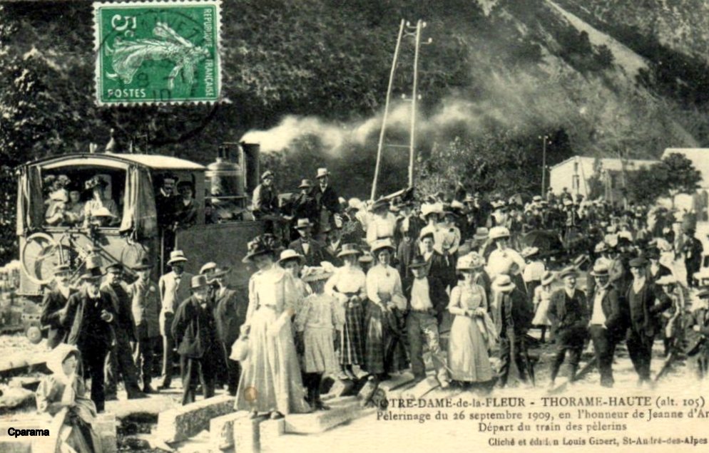
An 0-6-0T Pinguely industrial locomotive owned by Entreprise Orizet, on a pilgrims’ special, 26th September 1909, Notre Dame de la Fleur at Thorame-Haute. [3][8][12]
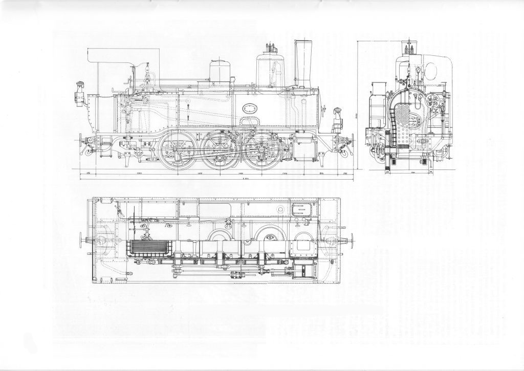
Drawing from Corpet-Louvet. [13]
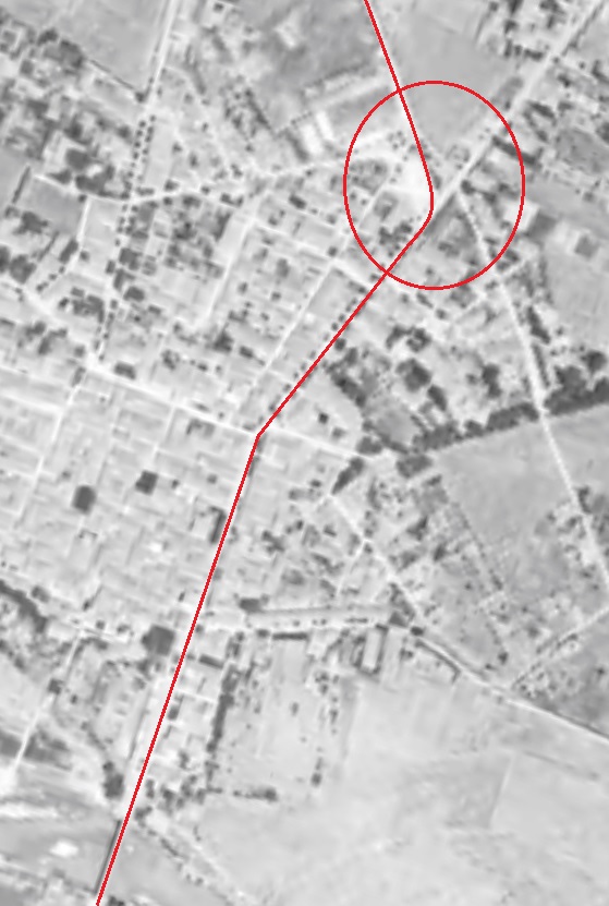
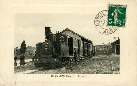
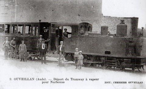
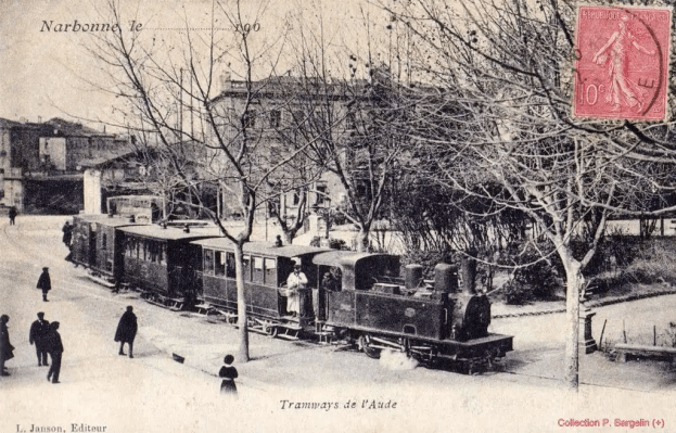
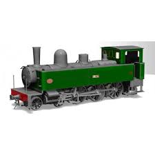
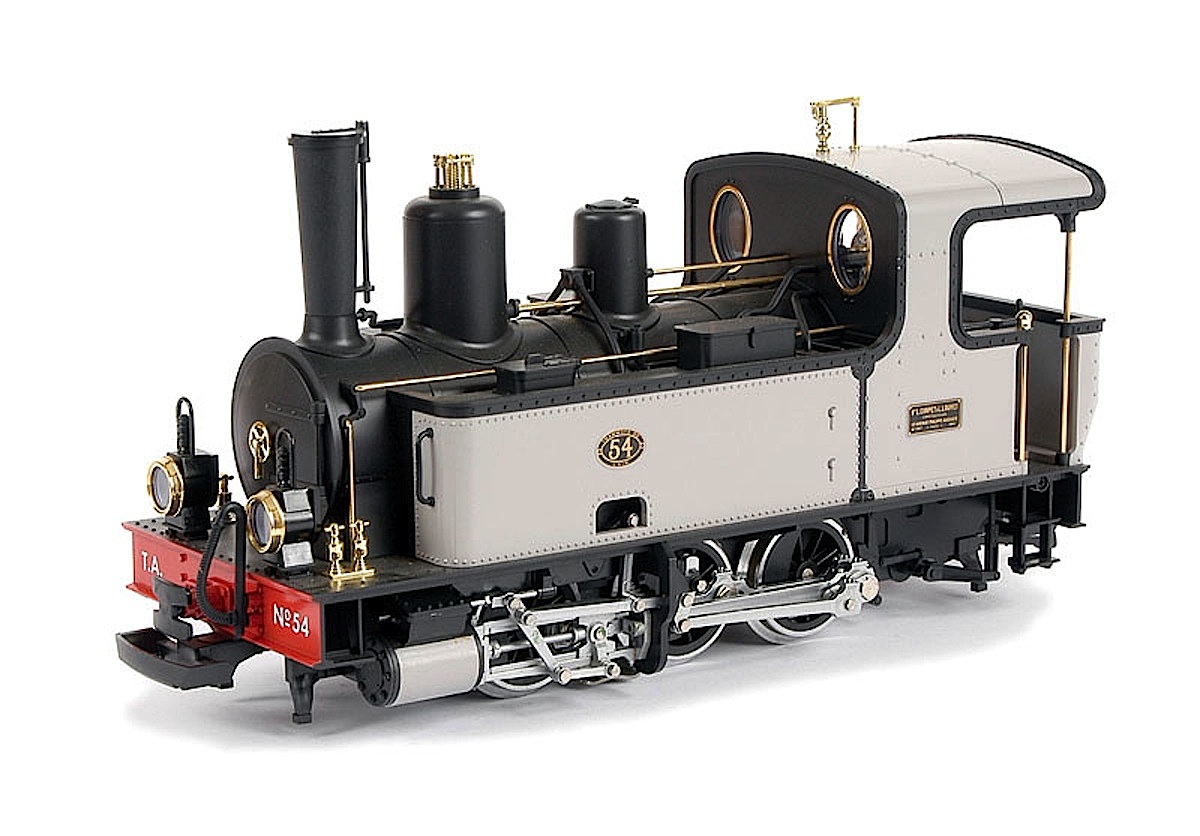
A model of one of these locomotives in the livery of the Tramways de l’Aude which I have also been writing about (cf. the series of blog posts which can be found on this site under the category ‘Railways and Tramways of South-Western France’ and which start with https://rogerfarnworth.com/2018/08/27/tramways-de-laude-overview-part-1). This model is No. 54 in the Tramways de l’Aude fleet of these small locomotives. The French company Lucien Corpet built 826 of these metre-gauge 0-6-0T locos for railways across Europe, and you can still see examples in use today. This LGB model offers all the classic LGB technical features: a powerful Bühler motor, weather-resistant gearbox, voltage stabilization, reliable power pick-ups and much more. The prototype was one of many built from 1890 onwards. 0-6-0T locomotives were the mainstay of Corpet’s production with weights ranging from 7 to 22 tons. Railway companies could order these locos from a catalogue. [14]

Corpet-Louvet was a family-size railway manufacturer, which nevertheless managed to find markets and satisfy its customers with simple, well-built and robust machines. Their locomotives came out of the workshops for a hundred years, straddling two centuries, the second half of the nineteenth century and the first of the twentieth century.

The small Corpet-Louvet locomotives are regularly cited as emblematic of the secondary railways. From 1855 until 1952, the plant produced 1962 locomotives. The majority of them were built to operate on metre-gauge rails and were tank engines. [19]

Three 0-6-0T Corpet-Louvet locomotives numbered 70 to 72 (as below) were ordered by the Chemins de Fer du Sud to operate on the line between Cogolin and St. Tropez. [19] 
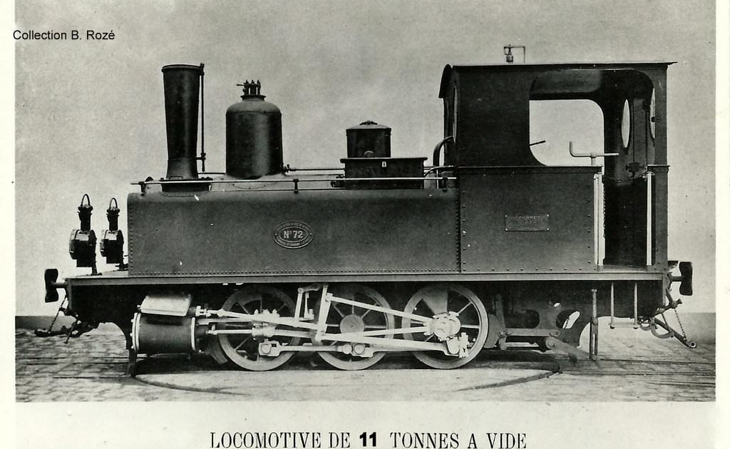
Further examples may have been used throughout the rest of the network including on the Nice to Digne Line. I have not yet been able to identify any. Whether certain locomotives were specifically allocated to the Central-Var or to the Alpes line, I do not know. Allocations may have changed over the years anyway and it is likely that some engines at least were used on both lines.

According to J. Banaudo, [25] very few Corpet-Louvet engines were used on the Alpes network bewteen Nice and Digne, apart from the four class D 031T (0-6-2T) No. 20-23 built 1894/5 with works numbers 619 to 622. I have not yet found a picture of one of these locos at work on the Nice to Digne line. These 031T (0-6-2T) Corpet locos on the Sud-France were large 28-ton steam locomotives. [27] One of these is shown in ex-works condition in the picture below.
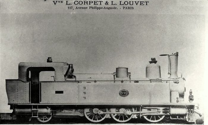
Corpet-Louvet Works No. 621 – No. 22 on the Sud-France network.

N° 19 L’Arve was a metre-gauge industrial 030T (0-6-0T) locomotive built 1887, acquired second-hand 1893, converted to standard-gauge 1897, withdrawn 1933. Designed for easy conversion from metre to standard-gauge and vice-versa, she was mainly used on the short mixed-gauge link and exchange sidings between Nice PLM (now SNCF) station and la Gare de la Sud de France.

Corpet-Louvet 030T (0-6-0T) Nos. 32 and 33 (1905/1906) from Régie des Chemins de fer du Sud-Ouest were borrowed during the war (1943/1945) (as were much bigger 141s (2-8-2s), also built by Corpet-Louvet) but saw very little use indeed.

No details are given by J. Banaudo [25] of the various industrial engines that were used by contractors when they built the lines. They may have included Corpet-Louvet 020T (0-4-0T) or 030T (0-6-0T) engines. [12]

I have one photograph of a 2-4-0T locomotive on the Nice to Digne line.
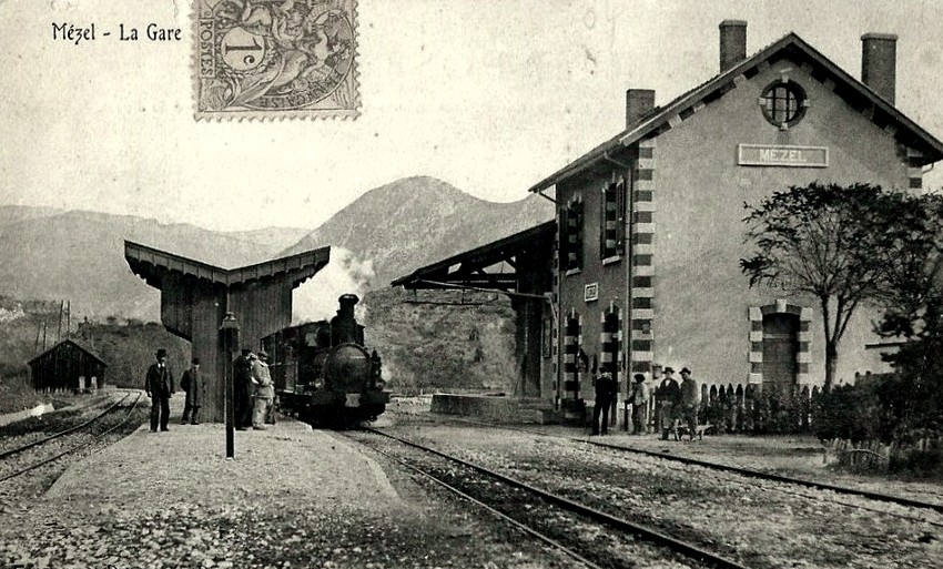
A 2-4-0T built by SACM stands at Mezel Station. The loco was in the series No. 5 – No. 12. The picture was taken when the line was completed as far as St André-les-Alpes only. [3][12] “The Société Alsacienne de Constructions Mécaniques (SACM) [Alsatian corporation of mechanical engineering] is an engineering company with its headquarters in MulhouseAlsacewhich produced railway locomotives, textile and printing machinery, diesel enginesboilers, lifting equipment, firearms and mining equipment. SACM also produced the first atomic reactor at Marcoule. The company was founded by André Koechlin in 1826 to produce textile machinery. In 1839, he opened a factory to build railway locomotives at Mulhouse in AlsaceThe business grew rapidly but in 1871, the annexation of Alsace-Lorraine by Germany, brought about the transfer of some production to Belfort in France. In 1872 the company merged with the Graffenstadencompany of Illkirch-Graffenstaden (a suburb of Strasbourg) to form SACM.” [23]

3. Mallet 0-4-4-0T

Mallets were relatively powerful locomotives for their size, having two sets of driving wheels. Relatively limited use of this type of locomotive was made on the Chemins de Fer du Sud de la France.An example of the class. Two of this type of locomotive were stabled in Toulon at the liberation in 1944. I believe that they were moved to Saint Raphael and loaded onto SNCF wagons for transport to the factory of Corpet-Lovet in 1945 for refurbishment. They could be found in use on the Nice to Digne line in 1946 and 1947.
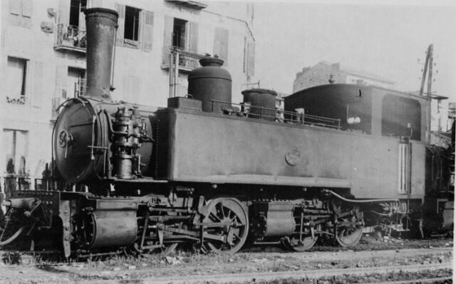
An SACM Mallet 0-4-4-0T at Nice.
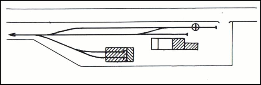
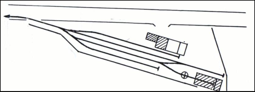
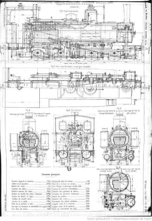
Mallet 0-4-4-0T drawings. [11]

4. Other forms of Steam Traction on the Line

A. 2-8-2 Tender Locomotives

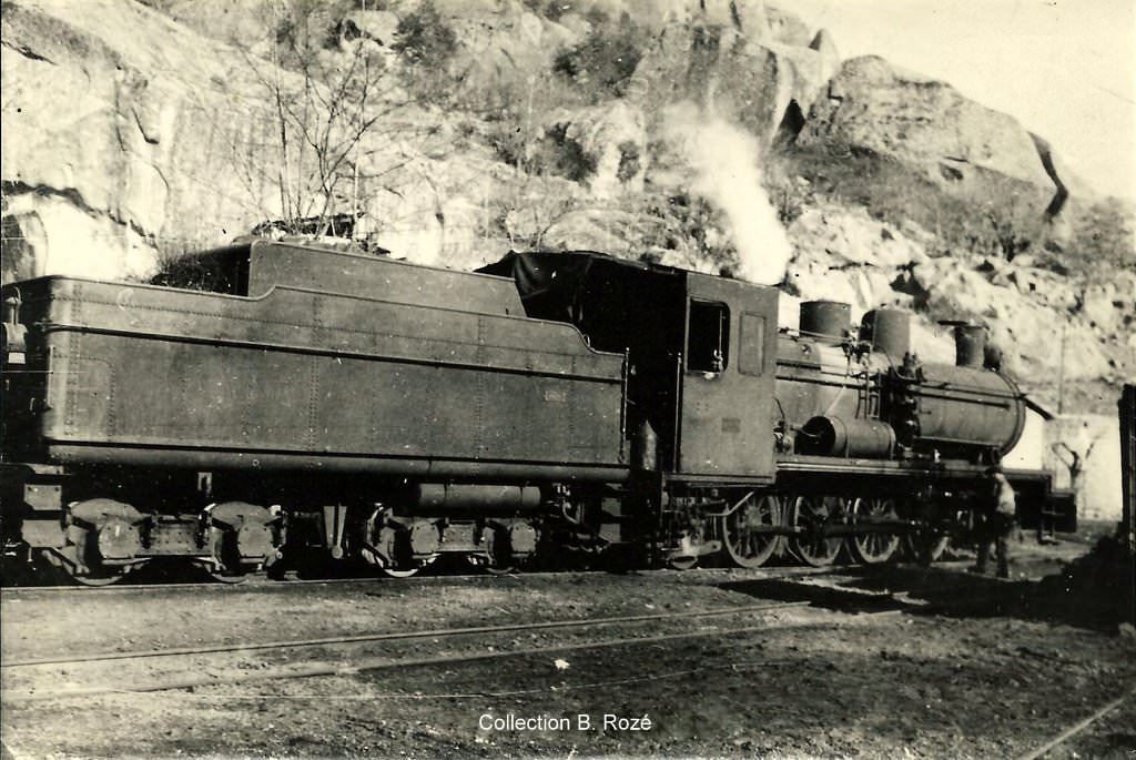
Locomotive No. 17 was one of a series of 7 locomotives built by the Corpet-Louvet establishments in La Courneuve and delivered in 1943 to the Railways of Provence. These machines were originally intended for the Dakar-Niger railway in Africa, but, because of the war, they were assigned to the Nice-Digne line. In the picture above, we see the loco at Annot (Basses-Alpes). These locomotives were not a success on the line. No. 17 ended its career on 14th May 1947 having travelled only 103,144 km. [3]

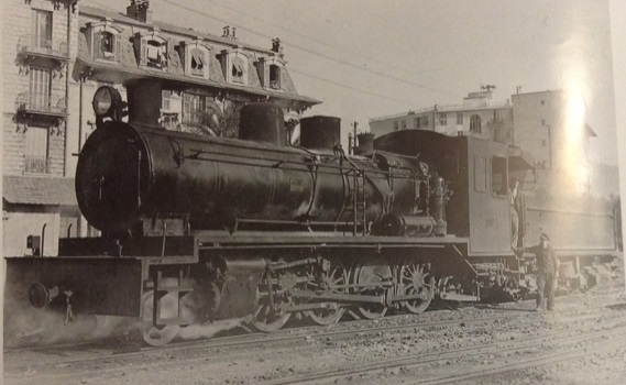
Locomotive No. 18 was another of this Class – seen here at Nice Station. [26]

B. 0-6-0 (Class A) and 2-4-0 (Class B) Tender Locomotives

In he early years after the opening of the network a number of 2-4-0 and 0-6-0 Tender locos were in use. Pictures are available of these at work on the Nice to Meyrargues line. I have not been able to find examples on the length between Nice and Colomars. However, it is pretty certain that they did run on the length between Colomars and Nice, and probable that theybran over the length of the line between Nice and Digne-les-Bains.

The Central Var had four 030 (0-6-0) tender locomotives, they were built in 1887 by SACM Belfort: No. 1 “Draguignan”; No. 2 “Flayosc”; No. 3 “Entrecasteaux”; No. 4 “Salernes.” [24]

An early photograph of one of the Class B locomotives on the turntable at Draguignan. [24]

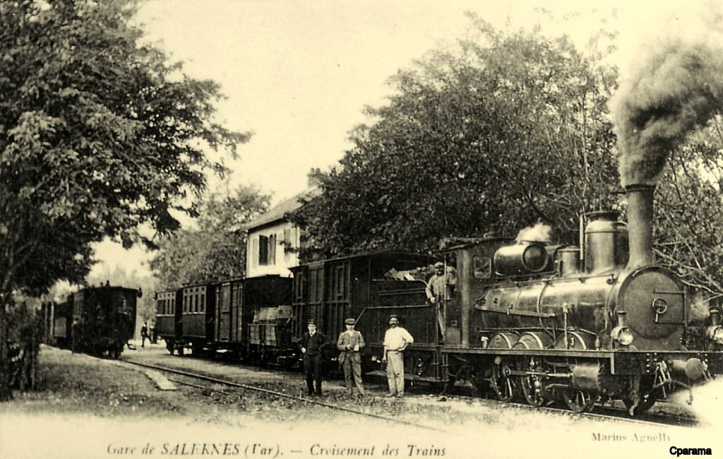
A SACM-Belfort 0-6-0 Tender Locomotive (Class A) at Salernes Station. [24]

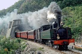
Modern Steam on the Nice to Digne Line

In modern times, three steam locomotives have been in use on the Nice of Digne Line. They have been renovated and maintained by the GECP (Groupe d’Etude pour les Chemins de fer de Provience):

A. The Portuguese [16][18] 2-4-6-0T

This steam locomotive was built in 1923 for the Portuguese Railways. It belongs to what was a series of 16 locomotives built by Henschel & Sohn for the Caminhos de Ferro do Estado (Minho e Douro division) in 1911 (CP No. E 201-204, ex MD 451-454), 1913 (CP E 205 / 206, ex MD 455-456) and 1923 (CP E 207-216, ex MD 457-466). Two other similar locomotives were delivered in 1923 to Companhia dos Caminhos from Ferro de Porto to Povoa de Varzim and Famalicao: PPF 16/17, later Norte 41/42 then CP E 181/182. [26]

During the early 1970s it was based in Sernada, used to haul passenger and freight trains on the lines Val de Vouga/Espinho to Sernada and Aveiro to Viseu. In 1975 it was transferred to Lousado, where it provided service on the line from Famalicao to Povoa de Varzim.

After being transferred to the central workshops in Puerto Campanhã it underwent its last revision in service in 1976. Later on it was based in Regua where it pulled mixed trains and work trains on the line from Corgo Regua to Chaves. It was taken out of service in 1981.

Three years later, the Portuguese Railways offered to sell twelve steam locomotives no longer in use. One of them was the E 211.

It was offered to and bought by GECP and in July 1986 towed from Regua to Vila-Real and then transferred onto road transport to be moved to the South of France. At the small station at Mezel-Chateauredon the locomotive was transferred back onto rails and moved to the depot at Puget-Therniers where ultimately it was to be refurbished. For a short period (1988-1992) it pulled the Train des Pignes between Puget and Annot, sometimes even between Nice and Digne-les-Bains.

The locomotive was then restored at the Lucato Termica workshops in Castelletto-Monferrato In the Piedmontaise province of Alessandria in Italy. That restoration took time, and it was not until 2009 that the locomotive was once again available in Puget-Thernier and June 2010 before it pulled its first Train des Pignes.
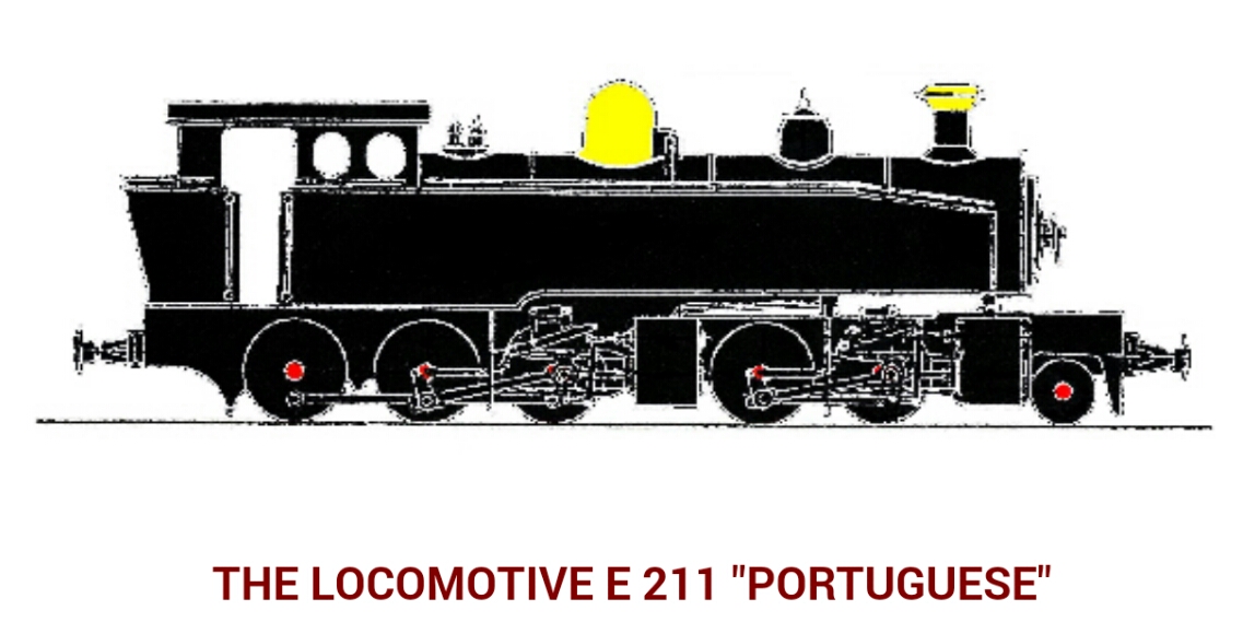
The full specification of the loco can be found on the GECP website. [16]
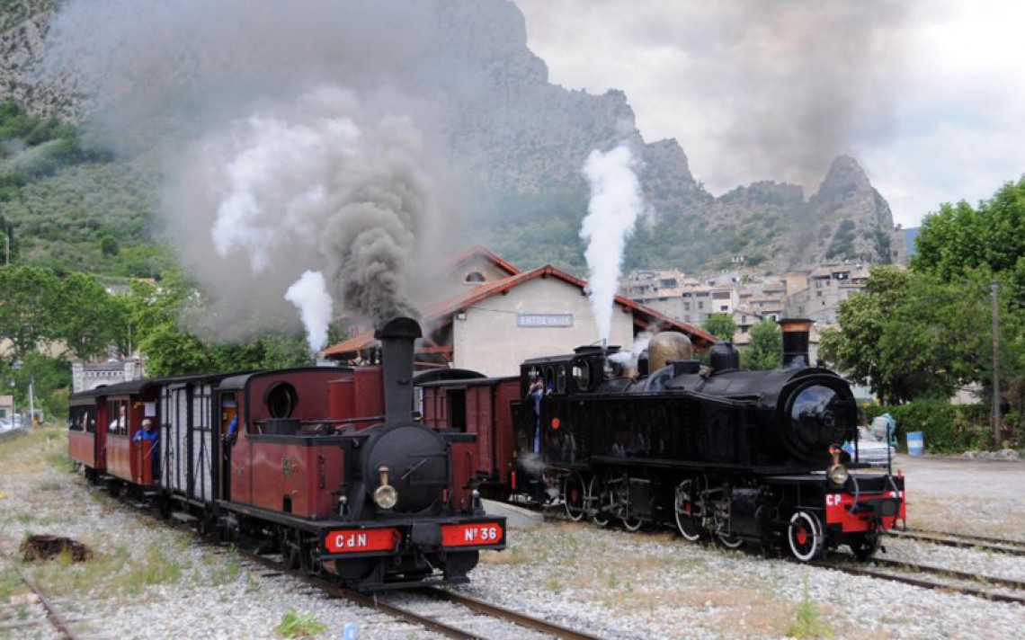
The Portuguese and Corpet-Louvet 0-6-0T.  [15]

B. 0-6-0T Corpet Louvet (CdN No.36)

This small 0-6-0T loco is seen in action in 2008 in the video below: [20]

LGB G-Scale Model of the CdN locomotive No. 36 which was built by Corpet Louvet an which, late in the 20th century, could be found running regularly between Puget-Theniers and Annot. [21]

No.36 (Lulu) is now housed at the Musée des tramways à vapeur et des chemins de fer secondaires français which is located alongside Valmondois railway station, in the small town of Butry-sur-Oise in the departement of Val-d’Oise, 30 kilometres north of Paris.
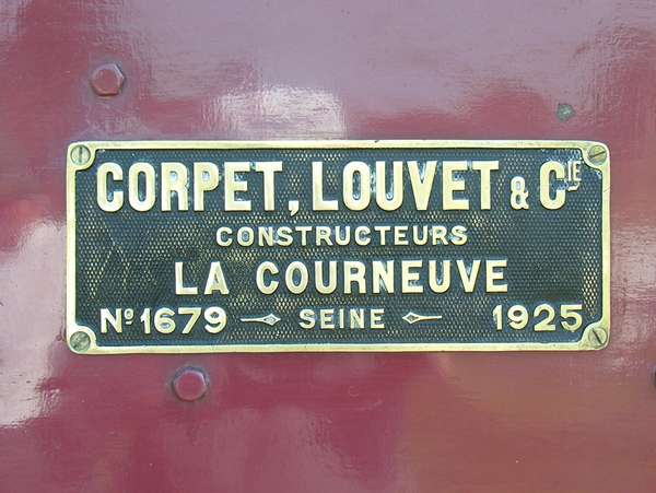
This locomotive was one of a series numbered 30 to 42, They all worked on the CdN from 1925 to the closing of the network in 1956. They developed a power of 375 hp, towed a load of 90 tonnes with a top speed of 50 km/hr. This was the maximum speed allowed on the network.
The last line where they were employed was the St.Brieuc – Paimpol line. At the closure of the network No. 36 (Lulu) remained exposed for a long time in front of the station of St Brieuc. [22]

C. 4-6-0T No. E327 ‘Bretonne’ [19]
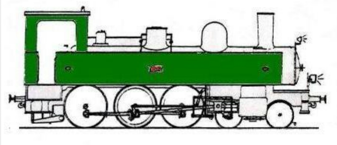
This locomotive was one of twelve commissioned by the Chemins de fer de l’Ouest for the operation of the metre-gauge lines of the Reseau Breton. It was built by the Compagnie de Fives-Lille, in Lille (Nord). It first saw service in September 1909 as No. E327 and was based at the  Caraix depot (Finistere). It ran for 58 years on that network. It is very similar to a whole range of 4-6-0T locomotives that were used on the Chemins de fer du Sud de la France.

After closure of the Reseau Breton by the SNCF, E327 was declared supernumery in September 196. It was saved from destruction by the Federation des Amis des Chemins de fer Secondaires (FACS). It was transferred in December 1969 to the Chemin de fer du Vivarais (CFV) but was only rarely used on that network. In March 1979, it appeared at ‘Exporail’ in Cannes and was thenmade available to the GECP in Nice to launch its tourist train.
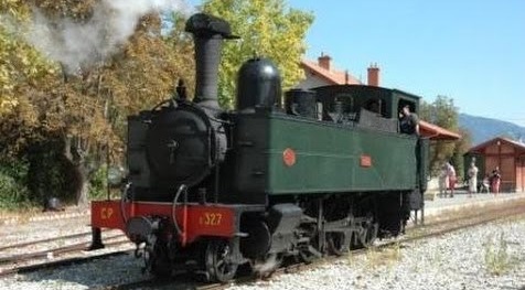
After a partial overhaul, the locomotive was used from July 1980 unil the end of the 1987 season. Renovated by l’Arsenal de Toulon, E327 reentered service in 1993 and continued in circulation until 2007. The loco is now waiting full refurbishment once again. Full details of the specification of E327 can be found on the GECP website. [17]

References

  1. https://rogerfarnworth.wordpress.com/2018/01/26/ligne-du-littoral-toulon-to-st-raphael-part-14-locomotives-and-rolling-stock-chemin-de-fer-de-provence-49
  2. Roland Le Corff; http://www.mes-annees-50.fr/Le_Macaron.htm. Retrieved 13th December 2017.
  3. José Banaudo; Les Train des Pignes; Les Editions de Cabri, 1999.
  4. http://www.cparama.com/forum/colomars-t23738.html, accessed 12th February 2018.
  5. https://www.cparama.com/forum/pont-de-gueydan-cne-de-saint-benoit-t28160.html, accessed on 10th August 2018.
  6. http://www.cparama.com/forum/thorame-haute-t28161.html, accessed on 10th August 2018.
  7. https://www.cparama.com/forum/annot-t1810-20.html, accessed on 2nd August 2018.
  8. https://www.cparama.com/forum/notre-dame-de-la-fleur-cne-thorame-haute-t28159.html, accessed on 14th August 2018.
  9. http://www.passion-metrique.net/forums/viewtopic.php?f=2&t=4143&start=3120.
  10. https://www.cparama.com/forum/locomotives-et-trains-divers-t23762-20.html, accessed on 23rd August 2018.
  11. http://www.bnf.fr, accessed on 23rd February 2018.
  12. A friend who posts on a few French Railway interest forums as 242TE66.
  13. http://tramwaytetg.free.fr/page22.htm, accessed on 31st October 2018.
  14. http://www.gbdb.info/details.php?image_id=164&sessionid=331671d706495c4df71149187a6e1d74&l=english, accessed on 31st October 2018.
  15. http://www.nicetourisme.com/nice/1360-train-des-pignes-a-vapeur, accessed on 17th November 2018.
  16. http://gecp.asso.fr/e211.html, accessed on 17th November 2018.
  17. http://gecp.asso.fr/e327.html, accessed on 17th November 2018.
  18. https://trainmec.blogspot.com/2013/06/train-des-pignes-la-portugaise-e-211.html, accessed on 7th December 2018.
  19. http://www.mes-annees-50.fr/Le_Macaron_locos_vapeur_Corpet.htm, accessed on 7th December 2018.
  20. http://wap.codedfilm.com/download/voie-m–trique-corpet-louvet-n–36-sur-les-chemins-de-fer-de-provence-juillet-2008/GdTmwDcLIY0, accessed on 10th December 2018.
  21. https://www.worthpoint.com/worthopedia/lgb-20790-corpet-louvet-d-36-steam-249760598, accessed on 10th December 2018.
  22. http://www.passion-metrique.net/forums/viewtopic.php?f=2&t=2122&start=0, accessed on 10th December 2018.
  23. https://en.m.wikipedia.org/wiki/Société_Alsacienne_de_Constructions_Mécaniques, accessed on 11th December 2018.
  24. https://rogerfarnworth.com/2018/02/23/locomotives-and-rolling-stock-on-the-central-var-line-chemins-de-fer-de-provence-50.
  25. José Banaudo; Le Siecle du Train des Pignes; Les Editions de Cabri, 1991.
  26. http://www.passion-metrique.net/forums/viewtopic.php?f=2&t=8154&start=90, accessed on 16th December 2018.
  27. http://passion-metrique.net/forums/viewtopic.php?t=10561&start=15, accessed on 17th December 2018.

Manchester Victoria’s Telpher

Who knows what a Telpher is?

A small travelling car, usually driven by electricity, suspended from or moving on an overhead rail or cable. [3] The Dictionary of Civil Engineering [1] has this entry:

telfer, telpher, monorail: An electric hoist hanging from a wheeled cab moving on a single overhead rail, occasionally from a steel rope. It is used in factories, hung from roof girders and over dams being built. An overhead gantry may be built to carry the rail. The difference between an aerial ropeway and a rope-borne telfer is that telfers are driven by a motor in the cab, ropeways are pulled by a rope driven by a stationary engine.

A Meccano Telpher. [4]

Telpher are still used in modern factories. The image below shows a factory crane currently on sale. The green moving element is referred to as the Telpher. [7]

Manchester Victoria Railway Station had a Telpher!

At least that is the claim of an article in BackTrack Magazine. [2] The ‘telpher’ at Manchester Victoria Station did not quite comply with the definition given in the Dictionary of  Civil Engineering because it was made up of a dual rail system. Wells says: “It was erected in 1898/9 by Mather & Platt, Salford Iron Works. Two rails were suspended from the roof, comprising steel rails 4.5in by 0.75in with a gauge of 11.5in, on which a trolley machine ran on four wheels. It was designed to lift 15cwt, although the structure itself [could] withstand twice that load.”The telpher with its basket grounded on Platform 5 at Victoria Station in 1919. The signal controls the exit across the LNWR lines. This was the platform (later No. 11) which was extended to join the LNWR’s Exchange Station Platform 3 to create, on opening in 1929, what was claimed to be Europe’s longest platform. [5]

The Telpher was introduced by Sir John A. F. Aspinall, the Lancashire and Yorkshire Railway’s Chief Mechanical Engineer. It ran from the parcels office across the full width of the station. It was about 300 yards long. Over the course of an average week around 100 miles were covered moving something like 1000 baskets. [2] The rails for the Telpher can be seen in the featured image at the top of this post. [8]

The costs included 1s 6d per day in electricity and the pay of the various, usually young, operators.

It was used, primarily, to transfer parcels between the parcels office and the different platforms. At busy times parcels could also be transferred directly from one platform to another.

Three Telpher units were used. Two were in service or available to use at any one time. The third being kept as a spare in case of breakdown. Three young men were designated as operators in normal traffic conditions and the Telpher was kept active 24 hours a day. [2]

During the most busy periods, at Easter, Whitsun and Christmas, four young men were employed working 12 hour shifts and two Telpher units were kept operational throughout a 24 hour day.

After the grouping, the young men (teenagers) were supplied by the LMS Electrical Department and their wages were about 25 shillings a week (£1.25/week). [2]An excellent high level view. [9]

Fifty four baskets were provided, each measuring 5ft by 3ft by 2ft 9in. On the early shift (6.00am to 2.00pm) 30 loads were taken to various trains and the same number were returned to the Parcels Office on Platform 16. [2]

The later shifts saw, respectively, 25 loads out and 40 back, and 60 loads in both directions.

The Telpher units operated off a DC supply throughout the interwar years. In 1940, Manchester Corporation decided to change the electricity supply from DC to AC. The change would have resulted in conversion costs of around £4000. Discussions took place about the viability of the Telpher given the very high conversion costs. [2]

Over Christmas 1940, the matter was taken out of the hands of the LMS. The Blitz on the night of 23rd December 1940 destroyed the roof of the station and demolished the Telpher. It was not replaced. [6]

Another picture of the Telpher in operation. Noel Coates notes that it was an invention of Aspinwall, in 1899, to allow the rapid collection and distribution of parcels to waiting trains across the station. … At periodic intervals along its path, loading gauges were provided to allow the operator to judge if he would clear carriage roofs. (c) National Railway Museum. [10]

A sad addendum to the story of the Telpher

Alice Goulding, a 20-year-old globe cleaner for the Lancashire and Yorkshire Railway (LYR), was killed by the telpher. Born on 12th October 1898, by age thirteen had lost her mother and her father (an engine driver). She joined the LYR as a temporary war worker in July 1918. On 27th February 1919, Alice was doing her usual daily duties. She climbed atop the roof of a carriage to clean the globes of the gas lamps, and whilst she  was walking along it, she was struck by the parcel basket and thrown onto the tracks. The telpher was being driven in reverse by a 17-year-old lad. After Miss Goulding’s death, the LYR had the telpher adjusted so that the driver always faced the direction of travel, and warned other ‘globers’ to keep a look out for the basket and to prostrate themselves flat on the carriage roof if they saw it motoring towards them. [11]

References

  1. Telfer/Telpher; John S Scott; Dictionary of Civil Engineering; 3rd Ed. 1980: p449.
  2. Jeffrey Wells; Manchester’s Victoria Station in Focus; BackTrack Magazine Volume 26, No. 4, April 2012; Pendragon Publishing, York: p248-252.
  3. https://www.thefreedictionary.com/telpher, accessed on 27th November 2018.
  4. https://www.meccanoindex.co.uk/Mmanuals/Smodels.php?page=18&Smotor=0&Tsearch=&Soutfit=0&Sdate=37&M_era=&Srow=&Edate=81&id=1513172671, accessed on 28th November 2018.
  5. Pendragon Collection: see [2] above.
  6. Tom Wray; Manchester Victoria Station; Lancashire and Yorkshire Railway Society 2004: p72.
  7. https://www.alibaba.com/countrysearch/CN/foundry-workshop.html, accessed on 2nd December 2018.
  8. http://www.hall-royd-junction.co.uk/Hall_Royd_Prototype/Manchester_Victoria_Past-Present.html, accessed on 9th December 2018.
  9. https://www.geneanet.org/cartes-postales/view/6094467#0, accessed on 9th December 2018.
  10. Noel Coates; Lancashire & Yorkshire Railway Miscellany; Oxford Publishing Company, 1983, plate 5.
  11. This short sad addendum was provided for me by Helena Wojtczak and comes from her book. … H. Wojtczak; Railwaywomen; Hastings Press, 2005.

Tramways de l’Aude – Narbonne to Fleury d’Aude

Narbonne’s tramways have been explored in some depth in my previous post …..

Tramways de l’Aude – Tramways in Narbonne

The route to Fleury set off Northeast from the tramway station on the forecourt of the Gare du Midi in Narbonne. After a very short distance the tramway route turned to a more southeasterly direction and in turn, within a short distance, left behind the suburbs of Narbonne.Things in the early 21st century are much different. In the image above the line can be seen leaving the station and heading East. [1] In the image below that line is now a road flanked by domestic dwellings. The cemetery appears to be essentially unchanged.The route as far as Vinnasan is shown on a composite of aerial photographs from 1939 to 1958 below. [1] Most of the route followed what is now the D68 over relatively flat countryside. I have not been able to find any images of the tramway between Narbonne and Vinnasan. The Google Streetview images below show the route of the tramway through what were open fields and are now suburbs of Narbonne.The old road and tramway route are on the left.

The tramway crossed farmland and a number of irrigation canals before reaching Vinnasin.

Vinassan

Vinnasan is now sited very close to the A9/E80 Autoroute which runs just to the East of the area of the adjacent aerial image. The tramway route has been superimposed onto an aerial image from 1958, although it would by that date have been long-gone.

This is a close-up image of the top right of the above ‘snake’ illustrating the length of the route to Vinnasan from Narbonne. The tramway by-passed the centre of the village, taking a more easterly route than the main north-south road through the village (now the D31). The postcard images above come from the central area of Vinnasan, both taken from the main north-south road which is now the D31. They are matched to modern images which show relatively little change. [2][3] The tramway ran to the east of the main village road.

North of Vinnasan, the tramway followed the modern D31 north to a T-junction with the road between Coursan and Salled’Aude. The present day D1118 meets the D31 and the D31 turns East to Salles d’Aude.

From the junction the tramway continued eastwards to Salles d’Aude past the Winery of Chateau Pech-Celeyran-Saint-Exupery.

Salles d’Aude

This 1945 aerial image shows Salles d’Aude and the road which is now the modern D31 crossing the lower half of the old village from West to East, entering immediately below the woodland in the top left of the image and exiting off the bottom edge of the image close to the right-hand corner. The vestiges of the tramway route can be seen to the south side of the properties which flank the road [1]This picture is taken from South of the village and shows the tramway route on embankment in front of the village. It runs approximately along the line of what is now Rue du Grimal. [4]

The station was sited to the Southeast of the village in the area highlighted by the green ellipse on the aerial image above, which places it some distance to the right of the picture immediately above.Sketch plan of the Station at Salles d’Aude. [5]The Station at Salles d’Aude. [5]Corpet-Louvet 0-6-0T No. 21 at Salles d’Aude. [5]Another Corpet-Louvet 0-6-0T, this time unidentified, at the Station. [5]

It was only a short distance from Salles d’Aude to Fleury d’Aude. Tha station at Salles D’Aude was at the topleft of the satellite image below. The tramway route is shown in red and the location of the station at Fleury d’Aude is shown with a green box both on the satellite image and the aerial photo below.

Fleury d’Aude

The western entrance to the village is shown on this extract from a 1945 aerial photograph. The tramway station location is highlighted by the green rectangle. By 1945, the station site had already been subsumed into the Co-op site.

The centre of the village of Fleury d’Aude is shown below on the next 1945 aerial image. The central circular area of the old village is typical of many such villages in Southern France. The smaller aerial image above was taken at the same time as the one below and abuts directly onto it.The station was out to the West of the centre of the village. The building in the bottom right of the green rectangle appears in a number of the pictures below. It is at the right-had side of the sketch plan below, just beyond the station site boundary on the sketch. It can be seen beyond the tram in the first postcard image below. [5]The station at Fleury d’Aude. [6]Corpet-Louvet 0-6-0T No. 1 at Fleury d’Aude Station. [6]The two images above show the building referred to in the last paragraph above. The first is a closer image of the building on an early 20th century postcard the second is taken in the early 21st century.The station cafe and passenger and goods facilities. The engine shed is visible behind the locomotive which is preparing to leave for Narbonne. [6]The cafe building in the early 21st Century with the modern Co-op buildings on the site of the station.Fleury d’Aude Station. [6]

The Co-op which was built on the station site is called La Vendemiaire.[7] The Co-op was created in 1937 and the building opened its doors to the wine harvest in 1938. In 1979, 652 members still cultivated 889 hectares of vines (just a little more than one hectare per cooperator) and the cellar vinified 91,000 hectoliters of table wines.The Co-op building soon after construction in the late 1930s. The tramway station was under the forecourt and the facade of the new building. The brick building at the left of the picture is the building which housed the station cafe and appears in images above. [8]

This is the final planned post on the Tramways de l’Aude.

I hope that you have enjoyed the journey.

References

  1. https://remonterletemps.ign.fr, accessed on 20th to 27th November 2018.
  2. https://www.fortunapost.com/cartes-postales-francaises/3261-carte-postale-ancienne-11-vinassan-avenue-de-coursan.html, accessed on 15th November 2018.
  3. https://www.fortunapost.com/cartes-postales-francaises/3262-carte-postale-ancienne-11-vinassan-mission-et-mairie-petrolette-sur-cale.html, accessed on 30th November 2018.
  4. http://www.sallesdaude.fr/fr/decouvrir/un-peu-dhistoire, accessed on 30th November 2018.
  5. http://www.cpaaude.fr/THEMES/TRAMWAYS/index_fichiers/Page1105.htm, accessed on 15th November 2018.
  6. https://www.cparama.com/forum/fleury-d-aude-t259.html, accessed on 15th November 2018
  7. http://www.lavendemiaire.com, accessed on 3rd December 2018.
  8. http://www.cavescooperatives.fr/article-27593489.html, accessed on 2nd December 2018.


Tramways de l’Aude – Narbonne to Ouveillan

Trams to Ouveillan took a relatively tortuous route out of Narbonne. The route is covered well on this link:

Tramways de l’Aude – Tramways in Narbonne

For the sake of completeness, some of the details on that link are repeated here ….

Narbonne

The tramway station was sited on the forecourt of the Gare du Midi as shown in the image below. The tramway station building is on the right of the picture.Trams to Ouveillan left the station in a southeasterly direction travelling roughly in parallel with the Midi mainline. The route to Thezan (Line No. 1, below) hugged the boundary wall of the Gare du Midi’s yard, the route to Ouveillan (Line No. 3, below) diverted slightly to the East.The tram (above) leaves the station and heads Southwest. It follows this route to the East of the Statue des Combatants. [7]The tram continues heading South towards the Canal du Midi. [8]This image shows a tram further along the route to Ouveillan (Line No. 3  above). It has reached the point on its route which is furthest to the Southwest and is now passing under the standard gauge line before turning Northeast. [9]The tramway route to Ouveillan (black arrow) ran along what is now the Quai d’Alsace and then turned Northeast as shown below.The tramway passed under the Standard Gauge line as shown in the 1930 aerial image above and then turned North around the boundary wall of the station goods yard. [10]

It then followed that boundary wall in a northeasterly direction. Its own marshalling yard is shown on the adjacent image. [10]

The next image shows the further extension of the line alongside the Western boundary of the Gare du Midi goods yard heading North-east towards Cuxac-d’Aude. [10]The monochrome images above have been aligned to show the tramway running up and down the photograph. It actually ran in a more northeasterly direction. The tramway followed what is now the D913 Rue de Cuxac along the western side of the large standard gauge facilities until it reached a branch to a series of sidings and a transshipment wharf/shed. At this point the mainline drifted to the West to follow the line of the Canal du Midi. It can be seen running towards the top left of the picture above. [17]This Google Streetview image shows the line of the tramway to Ouveillan in black and the approximate line of the route into the transshipment yard and wharf in red. In this post we are following the black arrow!The tree to the right of this image marks the point vthat the tramway aligns itself to the Canal. For some distance now the trams ran alongside the Canal behind the line of trees which flanked the Canal.

The next two views show the Canal du Midi flanked by trees. I believe that the tramway ran beyond the trees on the far bank of the Canal in each image.The Canal du Midi looking South.The Canal du Midi looking North from the same location.

The trams had an easy journey alongside the Canal and only left it when the Canal turned away from the route the tram needed to take to Cuxac.

The tramway alignment was approximately as shown on the aerial photograph from 1945. The bridge over the River Aude can be seen clearly in the aerial image just at the point where the tramway reaches the village of Cuxac d’Aude.

Cuxac d’Aude

The village of Cuxac was approached by trams crossing the Rive Aude on the bridge illustrated below. [2] The bridge was a steel truss girder bridge which has now been replaced.The first image below is shows the centre of Cuxac from the air in 1945. The bridge over the River Aude can be picked out at the bottom of the picture. The tramway station is at the centre of the red oval. The tramway route is marked as a red line. [6]The station location is shown in the mid 1970s on the next image (adjacent), and in the mid-1980s in the one below. [6]The final image (adjacent), shows the same area in the early 21st century from Google Earth. The tramway route is still evident in the street layout and the station building has been preserved and is in private ownership. It is used as a pizza takeaway business in the 21st century!

The picture immediately below is an image taken from north of the junction central to the adjacent image just above the town name and pink marker. The view looks southwards down Boulevard Jean Jaures. The curve in the tramway lines accommodates the change in direction of the road at the junction which is also evident in the adjacent image. [2]The second image (below), taken Just to the south of the one above, looks south towards Narbonne and so bears the legend, L’Avenue de Narbonne. [2]A similar location after the removal of the tramway. The street is now known as the Boulevard de Vingre. [4]Boulevard Jean Jaures or Boulevard de Vingre (D13) in the early 21st century. This image was taken from approximately the same location as the first postcard view of the street, also looking South.

Travelling North-northeast from the centre of the village along  what is now the D413, the trams ran on the West side of the road until they reached what was, in the early 20th century, primarily, open ground on the edge of the village where the station was built.A tram arrives at the Station in Cuxac from Narbonne having travelled through the village first. [3] This tram has travelled from Ouveillan and will go on through the village of Cuxac d’Aude to Narbonne. It obscures the view of the station building. [3]This tram has also travelled from Ouveillan and will go on through the village of Cuxac d’Aude to Narbonne. [3]This and the previous monochrome image show the station building to good effect. [4]This view shows the line ahead to Ouveillan as a tram arrives from there on its way to Narbonne. [5]

The journey to Ouveillan from Cuxac was over relatively level ground. Trams followed what is now the D13 through to Ouveillan, after travelling through the suburbs of Cuxac on the Rue Louis Mestre.On the way, trams passed through what is now known as Pont des Graves, as can been seen on the adjacent satellite image from Google Maps.

Pont des Graves

At this point the current D13 bridges the Canal d’Atterrissement de l’Etang de Capestang.

Back in 1939, which is the date of the earliest aerial image available, the bridge and canal were in place but the small community of Pont des Graves had still to form. This can be seen clearly on the aerial image below. [10]The journey from Pont des Graves to Ouveillan was direct and level, following the D13.

Ouveillan

The tramway entered Ouveillan along the Avenue de Narbonne.The tramway on Avenue de Narbonne. This view looks towards Cuxac. [1]Approximately the same location in the early 21st century.A train heads away from Ouveillan tramway station along the Avenue de Narbonne. [1]Approximately the same location in the early 21st century.Further Northwest along what is now the D13, the tramway is still visible, and this card refers to the road on which it is running as Avenue de la Gare. [1]The same location, once again in the 21st century.This is an earlier, pre-tramway view of the Avenue de la Gare. [11]This time the tramway is in place. The station is off to the left of the photographer. [11]Avenue de la Gare was also known as Avenue de Saint Chinian. It bears that alternative name today and is part of the modern D13. This postcard view looks back Southeast towards the centre of Ouveillan. [1]It seems that the road was known also as Avenue de la Croisade. This excellent view shows the tramway bearing off the main road into the station site. [1]Almost exactly the same location in the early 21st century. The station site is to the right of the main road beyond the houses.The station was in the open area to the right of the plane trees.In the light of the size of other Tramways de l’Aude stations the terminus at Ouveillan was well provided for in infrastructure terms and it was sited adjacent to what would become the wine co-op buildings of the town which can be seen in the Google Streetview image above. [12]

We finish this post with two images from the terminus at Ouveillan.

References

  1. https://www.delcampe.net/fr/cartes-postales/europe/france/11-aude/autres-communes?f=keyword:ouveillan, accessed on 25th November 2018.
  2. https://www.communes.com/cartes-postales-anciennes-cuxac-d-aude, accessed on 25th November 2018.
  3. https://www.cparama.com/forum/cuxac-t6776.html, accessed on 25th November 2018.
  4. http://www.en-noir-et-blanc.com/cuxac-d-aude-p1-1339.html, accessed on 25th November 2018.
  5. I picked up this image some time ago and did not keep a link reference for it. I cannot now find its original location on the internet. I will gladly add the relevant link if someone is able to point it out, accessed on 25th November 2018.
  6. https://remonterletemps.ign.fr, accessed on 25th November 2018.
  7. https://www.delcampe.net/fr/collections/cartes-postales/france/narbonne/narbonne-train-locomotive-avenue-de-la-gare-et-monument-des-combattants-chemin-de-fer-belle-animation-453866037.html, accessed on 2nd November 2018.
  8. https://www.delcampe.net/fr/collections/cartes-postales/france/narbonne/aude-11-narbonne-joli-plan-sur-les-boulevards-de-la-gare-et-du-college-avec-voiture-ancienne-animation-janson-343316390.html, accessed on 2nd November 2018.
  9. https://collection-jfm.fr/t/cartes-postales-anciennes/france/11-aude/narbonne-11, accessed on 4th November 2018.
  10. https://remonterletemps.ign.fr, accessed on 8th November 2018.
  11. http://www.belcaire-pyrenees.com/2016/10/test.html, accessed on 26th November 2018.
  12. http://www.cpaaude.fr/THEMES/TRAMWAYS/index_fichiers/Page2347.htm, accessed on 26th November 2018.


Ligne de Central Var – Postcript – A short walk near Seillans (Chemins de Fer de Provence 28a)

On 20th November 2018, my wife and I visited a few small villages near Fayence. This included an hour or two in and around Seillans.

In December 2017, I completed a blog about the metre-gauge Central Var line of the Chemins de Fer du Sud de la France. The full story can be found on my blog. Two posts covered the line close to Seillans:

Ligne de Central Var – Part 7 – Tanneron to Seillans (Chemins de Fer de Provence 27)

Ligne de Central Var – Part 8 – Seillans to Claviers (Chemins de Fer de Provence 28)

That blog focussed on a journey along the line from Nice to Meyrargues travelling from East to West. What pictures I was able to take in November 2017, were limited to those accessible from a vehicle in a single day trip.

This blog post looks at a very short length of the line to the West of the station at Seillans which we explored after lunch close to the Chappelle de Notre Dame de l’Ormeau which is marked in blue below and just happens to be close to the old station at Seillans which is itself a couple of kilometres from the village of Seillans.Seillans village on 20th November 2018.The area of our walk on 20th November 2018. The green lone approximates to the route oif the railway line.Approximately the same area, but this time in an aerial image from 1944. The railway was in use in the period immediately after the war and Seillans Station can be seen with track in place an an access road from the Fayence to Seillans road.

The pictures below show a stroll from East of La Gare to beyond the accommodation bridge in the bottom right of the satellite image above and a return journey along the same route.Approaching Seillans station building from the East on 20th November 2018. The station building (1) is in private hands. The picture is taken from the adjacent road with the old metre-gauge line and yard beyond the station building on its South side.Immediately to the West of the Route de Fayence (D19), the railway crossed a small stream. The bridge is long-gone although the three ends of the parapets remain (2). The bridge has been replaced by a small footbridge. The route of the railway can be seen disappearing into the distance, (20th November 2018).After a short straight section, the railway turned through a slight curve and crossed another, larger stream, adjacent to what are now the village sewage works. The structure was significant (3). This picture was taken after scrambling down the steep embankment, (20th November 2018).

Beyond the stream the footpath following the railway route becomes the road access to the treatment works and is a tarmacked single lane road. All the images below were taken on the 20th November 2018 unless staed and referenced otherwise.The accommodation bridge in the distance is that marked (4) on the satellite image.

A short distance after reaching the bridge  in the image above, we returned to the Station and our car which was parked at the Chappelle de Notre Dame de l’Ormeau.Looking Northeast along the line, back towards Seillans Station.Looking Northeast at the point where the railway began to turn eastwards, this picture shows the parapets of the bridge adjacent to the sewage works (3).Two pictures taken on the walk back towards Seillans Station.The view of the Chappelle de Notre Dame de l’Ormeau which would have been seen from the train. A picture taken by me, and a postcard image from the early 1900s. [1]Two pictures of the station building taken from the West.

The station building taken from the Southwest.


References

1. https://www.delcampe.net/fr/cartes-postales/europe/france/83-var/autres-communes?f=keyword:seillans, accessed on 20 the November 2018.

Ligne du Littoral (Toulon to St. Raphael) – Part 15a – November 2018 Visits to the Line (Chemins de Fer de Provence 81a)

Another Postscript.

This 1929 aerial photograph from the IGN site ‘remonterletemps.ign.fr’ really interests me. I discovered it on 19th November 2018 while staying in Saint-Raphael.

The centre of St. Raphael is in the middle of the picture, the relatively small harbour looks more expansive than it does now in the early 21st century. Watching some of the large yachts if the mega-rich manouvering in the harbour is interesting.

The large church building stood out much more clearly in the 1920s than it does today. The River Garonne was not built over in the way it is today.

The metre-gauge line can clearly be seen passing under what was the PLM standard-gayge mainline and climbing in an arc to meet the mainline at St. Raphael railway station. The metre-gauge sidings can be seen to the right-hand (East) side of the photo.

It is also possible to identify the metre-gauge passenger station building on the aerial image to the North of the mainline under what is now the site of the Gate Routiere.

The Google Earth satellite image below shows approximately the same location in the early 21st century. The grey roofed building houses the Gare Routiere and there are modern strictures over the site of the old goods yard.Little was done in the developments of the late 20th century to preserve significant aspects/views. As can be seen above there is a large modern block between the port and the church which obscures what could still have been an excellent view of the church. The images below show the effect of  modern development in this particular corner of the world!Perhaps surprisingly the alignment of the old metre-gauge line can still be picked out in this image. I have enhanced the scale a little in the image below and shown the approximate alignment with a green line. Tarmac covers most of the route shown. There is a break beneath the mainline.

Ligne du Littoral (Toulon to St. Raphael) – Part 15 – November 2018 Visits to the Line (Chemins de Fer de Provence 81)

On 13th and 16th November 2018, my wife (Jo) and I walked around St. Raphael and took some photographs of the location of Le Macaron railway station and updated the post below accordingly.

On 14th November we traced the line of Le Macaron between Ste. Maxine and St. Raphael. I was able as a result to add a PostScript to my earlier blog post on that length of Le Macaron. The revised post can be found at:

Ligne du Littoral (Toulon to St. Raphael) – Part 13 – Sainte Maxime via Aygulf and Fréjus to Saint Raphael (Chemins de Fer de Provence 48)

On Sunday 18th November, Jo and I travelled from St. Raphael, via the Sunday Market in Le Muy, to Hyeres. We also enjoyed an hour or so on the spit of land extending out from Hyeres towards Iles d’Hyeres and we had lunch next to La Tour Fondue. We spent the rest of the day following Le Macaron from Hyeres to Sainte-Maxime.

Nothing I saw on the journey caused me concern about the text of the series of blog posts about the route that I have written.

I was able to take a few pictures while on the journey, although there was little time to stop if the full journey was to be completed in daylight!

On the journey we were also able to make three detours. The first, to Les Bormettes and the site of the old torpedo factory at what is now known as Miramar. The second to the old perched village of Bormes les Mimosa. The third to St. Tropez.

We took a few photographs on Sunday 18th November and these follow at the end of this blog post, together with a few from other sources.

The relevant links to my blog are:

Ligne du Littoral (Toulon to St. Raphael) – Part 6 – Hyeres to Bormes les Mimosas (Chemins de Fer de Provence 41)

Ligne du Littoral (Toulon to St. Raphael) – Part 7 – La Londe & Les Bormettes (Chemins de Fer de Provence 42)

Ligne du Littoral (Toulon to St. Raphael) – Part 8 – Bormes les Mimosas to Cavalaire (Chemins de Fer de Provence 43)

Ligne du Littoral (Toulon to St. Raphael) – Part 9 – Cavalaire to La Foux les Pins (Chemins de Fer de Provence 44)

Ligne du Littoral (Toulon to St. Raphael) – Part 10 – La Foux les Pins to Saint-Tropez (Chemins de Fer de Provence 45)

Ligne du Littoral (Toulon to St. Raphael) – Part 11 – La Foux les Pins to Cogolin (Chemins de Fer de Provence 46)

Ligne du Littoral (Toulon to St. Raphael) – Part 12 – La Foux les Pins to Sainte Maxime (Chemins de Fer de Provence 47)

Some photographs … The majority my own, others are referenced below.

Le Muy, 18th November 2018.

Le Muy, Sunday Market. [1]

The remaining station at Hyeres is the SNCF standard-gauge station. [2]

A view out to sea from close to the branch-line to the torpedo factory (long-gone) at Miramar. The picture was taken on 18th November 2018.

The railway station building at La Londe-les-Maures taken from what was the line of the railway just to the West of the station on 18th November 2018.

The railway station building at La Londe-les-Maures taken from the South.

The railway station building at La Londe-les-Maures taken from what was the line of the railway just to the East of the station. This image was also captured on 18th November 2018.


Clearly this image was not taken in November! we drove around the village which sits high above the valley below and as a result high above its ancient railway station. [3]

The old station building at Cavalaire-sur-Mer taken from the North on 18th November 2018.

The same building also pictured on 18th November 2018. in remodelling the centre of the town the authorities have chosen to reflect its railway history by building a ‘railway’ into the paving. Flat metal and wooden piecs have been used to good effect.

The old village centred on the station and the present town has reflected that by running the ‘railway’ through the centre and, as can be seen in the image below has created a series of benches that mimic the old railway wagons of Le Macaron.

This image shows one of the buildings associated with the old branch-line to St. Tropez. It was also taken on 18th November 2018 as the sun was beginning to set. Evidnce of the existence of the station is preserved in the name of the road as the image below highlights.

The old station area in St. Tropez now forms a large tourist car-park as can be seen in this image taken on 18th November 2018.

St. Tropez in the evening sun on 18th November 2018.

References

  1. https://www.lebonguide.com/degustation/marche-du-muy_332155, accessed on 18th November 2018.
  2. http://archives.varmatin.com/hyeres/les-trains-de-retour-a-la-gare-dhyeres.2198511.html, accessed on 18th November 2018.
  3. https://www.bormeslesmimosas.com/fr/quoi-faire/visites-et-patrimoine/le-mimosa, accessed on 18th November 2018.

King’s Lynn Docks Branch – Part 4 (Miscellaneous)

Having completed a series of posts about the Dock Railways of King’s Lynn. I sat down this morning to a relatively relaxed breakfast with a copy of Back Track Magazine from March 2011 to find an article by Mike G. Fell OBE. [1]

The featured image at the top of this post shows the image at the head of the article in Back Track magazine. The resolution is much better in the magazine article. The caption for the main image reads as follows: ‘Alexandra Dock c 1877 after completion of the coal hoist and jetty which can be seen at the top left of the photograph but before construction of the Bentinck Dock. J. T. Cook’s coal depot is in the foreground. Note the dumb-buffered private owner wagons including those owned by Babbington Colliery, Nottingham, E. C. Bridges, the Darlington Coal &Coke Co., John G. Mitchell, Nunnery Colliery, Shweffield, and Colin McOlvin of King’s Lynn. Edward Curzon Bridges (1832-1900) was a King’s Lynn coal merchant.

The article in the Back Track magazine gives an excellent introduction to the Dock Railways of King’s Lynn. The same image from the article header is highlighted in a short discussion on the King’s Lynn Forums about the Fisher Fleet in King’s Lynn. [2]

That image also set me a challenge … to see what else I could find out about private owner wagons which were based in King’s Lynn and may have frequented the Docks.

This wagon is featured in a thread on RMWeb and is an O Gauge model. [3]

Massingham is close to King’s Lynn [4]

The easiest images to find on line are ones of models of local wagons! There are a variety of scales above. The last two come from transfers made by Robbie’s Rolling Stock. [5]

I discovered this image while browsing the net. It shows a wagon label for a load being moved from Thorne Colliery to King’s Lynn docks. This is a sample of what can be found online and it links directly to a site on smugmugn which has a lot of copyright images of bills of lading including a number associated with King’s Lynn. [6] [8]

While searching for information about P. O. Wagons I came across a thread on RMWeb started by ‘Mark P’ which prompts me to consider a detailed post about King’s Lynn Railway Station. Definitely something for the future. Just a couple of images from that thread follow. [7]

47003 crosses the Tennyson Avenue level crossing bringing a British Industrial Sand train in from Middleton Towers. [7]

This shows the view of the diesel refuelling depot as seen from the pedestrian footbridge on Tennyson Avenue. [7]

And finally, for this miscellany, is there any possibility of part of the Docks branch being reopened? This is an interesting question and seems to be tied in with the question of the viability not the reopening of the King’s Lynn to Hunstantion branch. The original route of the nline to Hunstanton followed the boundary of the playing fields of what were King Edward VII Grammar School and then Secondary Modern in Gaywood Park.

The Lynn News posed two possible alternatives in an article in 2018. [9] Their article refers to another article in Rail Magazine by Howard Johnston. Lynn News said: “It is far too early to suggest what route the ‘new’ railway would take. If it left the centre of King’s Lynn on the tracks of the old docks line (which is still technically open), it would run closer to the coast than before, with a joint station possibly serving Snettisham and Dersingham, then Heacham, and a new parkway-style station on the eastern side of Hunstanton. An alternative route is to leave the Middleton Towers freight line at a new junction a little way north of Hardwick estate, with an additional halt at the Queen Elizabeth Hospital.” [9][10]

The newspaper aslo makes it clear that the line could always have been viable. Breeching did not suggest its closure. In fact he saw a future for the line, British Railways deliberately drove away business by cutting out through services, stopping day excursions, sacking staff, and turning stations into unwelcoming unstaffed halts that were prone to decay and vandalism. BR also massaged the figures bybrefusing to include within passenger numbers anyone whose journey originated from south of King’s Lynn. This cut the annual total passenger numbers from over 200,000 to just 40,000 – an 80 per cent fall – it beacme very easy to justify the closure of the line. [9][10]

References

  1. Mike G. Fell; ‘The King’s Lynn Docks & Railway Company’; in Michael Blakemore (ed.) Back Track Volume 25 No. 3, March 2011; p144-149.
  2. http://www.kingslynn-forums.co.uk/viewtopic.php?f=14&t=160&start=15, accessed on 5th November 2018.
  3. http://www.rmweb.co.uk/community/index.php?/topic/118730-model-railrapido-trains-gerlner-j70-0-6-0t-project-toby/page-7, accessed on 5th November 2018.
  4. https://www.powsides.co.uk/www.powsides.co.uk/info.php?p=0&search=softley, accessed on 5th November 2018.
  5. http://www.robbiesrollingstock.co.uk/E_Mids.htm, first accessed in 2010, this access date is 6th November 2018.
  6. https://www.google.co.uk/search?q=private+owner+wagons+king%27s+lynn&client=tablet-android-lenovo&prmd=ismvn&source=lnms&sa=X&ved=0ahUKEwjx0ZSqz7_eAhWJKcAKHU7QDvEQ_AUIDygA&biw=800&bih=1280&dpr=1#imgrc=75LB40E_3iGwbM:, accessed on 6th November 2018.
  7. http://www.rmweb.co.uk/community/index.php?/topic/54052-based-on-kings-lynn, accessed on 6th November 2018.
  8. https://transportsofdelight.smugmug.com, accessed on 6th November 2018.
  9. https://www.lynnnews.co.uk/news/the-case-for-rebuilding-the-rail-line-to-hunstanton-1-8457250, accessed on 6th November 2018.
  10. https://anonw.com/2018/04/13/putting-right-norfolks-150m-rail-mistake, accessed on 6th November 2018. This blog quotes the article in Issue No. 849 of Rail Magazine.

Tramways de l’Aude – Tramways in Narbonne

The city of Narbonne was served by three tramway routes. The first  travelled West to Thezan and the remainder of the network of the Tramways de l’Aude. That tram route is covered in the post which can be found on the link below:

Tramways de l’Aude – Thezan to Narbonne

Trams left the station building which was opposite the Gare du Midi and headed South and West through the city before leaving in the direction of Thezan. This was Line No. 1 on the sketch plan below. [16]The tramway station building was small. It can be seen above, just in front of the water tanks outside the Gare du Midi. The tramway itself is also visible above, running from the tramway  station building off to the left of the picture. [1]

The tramway ran on the right-hand side of the Gare du Midi boundary wall and can just be picked out on the adjacent aerial image from 1930s. [17]The tramway building can be seen on the right of this image. [2]The Gare du Midi [3][10]The Gare du Midi with the tramway in front. The water tanks and the tramway station are visible once again. [3]A similar view taken in the early 21st century.A great shot (above) of the tramway station with the Gare du Midi behind and the tramway track just in front – in the bottom left of the picture. [18]

The Gare du Midi building dominates the adjacent picture. The relative size of the tramway building can easily be seen. The building sits to the right of the two watertanks. The tramway can also be seen on the right-hand side of the image. [17]The station shown from the opposite direction. The photographer is standing close to the tramway building. [4]One final postcard view of the station forecourt in the early 1900s. [9]The tram (above) leaves the station and heads Southwest. There are two routes travelling in this direction. The one pictured to the East of the Statue des Combatants and one (not visible) to the West of the statue. The route to the West of the statue is the one which heads for Thezan. The tram in this picture is on the first part of the tramway to Ouveillan. [8]Approximately the same view in the early 21st century.This 1930 aerial image shows the tramway junction to the North of the Statue des Combatants. [17]Taken from the Northeast, this view shows the Statue des Combatants and the approximate alignment of the two tramway routes heading Southwest from the Gare du Midi. Line No. 1 heads for Thezan de Corbieres. Line No. 3 heads Southwest before turning through 180 degrees, passing under the railway line and heading for Ouveillan.A little further Southwest the Boulevard du Gare (now Boulevard Frederic Mistral) met the Boulevard du College (now Boulevard Marcel Sembat). The tramway track was on the left-hand side of the Boulevard du Gare which is on the left of the picture. [10]The same location in the early 21st century.Heading South towards the Canal du Midi. [10]This image shows a tram further along the route to Ouveillan (Line No. 3 on the sketch plan above). It has reached the point on its route which is furthest to the Southwest and is now passing under the standard gauge line before turning Northeast. [13]This image shows the three bridges over the Canal du Midi and I have added the two tramway routes for clarity. Both can be picked out on the image.[5]The same location and again it is just possible to pick out the tramway tracks. [6]The under-bridge in the 21st century.The Standard Gauge Line can be glimpsed in the upper right quadrant of this picture. The bridge carrying what we have called Line No. 1 in just in front of the railway bridge. Line No. 3 does not quite make it onto the right-hand side of the image. [7]A tram returning from Ouveillan. The railway bridge can just be glimpsed in the left background. This location is marked on the sketch plan of the tramways above as a single dot which is elsewhere given the name, ‘Arret Narbonne Ville.’ [15][16]A 21st Century picture of the same location but with the camera much closer to road level. The building on the right is that on he right of the monochrome image and the building on the left clearly match those in the monochrome image above.This picture shows the location of the Arret Narbonne Ville with a tram leaving to the right to head for the Gare du Midi. The same direction as the tram in the monochrome image above. [16]The two tramways are easily seen on this 1930s aerial photograph. Line No. 1 runs from top to bottom of the image, Line No. 3 runs left to right. The Canal du Midi in just off the bottom of the photo. [17]The tramway route to Ouveillan ran along what is now the Quai d’Alsace and then turned Northeast as shown below. The tramway passed under the Standard Gauge line as shown in the 1930 aerial image above and then turned North around the boundary wall of the station goods yard. [17]

It then followed that boundary wall in a northeasterly direction. Its own marshalling yard is shown on the adjacent image. [17]

This location was not the only possible point of exchange between the metre-gauge line and the standard gauge line. The relative size of the facilities is striking. The tramway’s compact facilities kept the tramway overheads low.This image is taken from a point on the bottom edge of the aerial image immediately above looking North into the area of the tramway sidings which has now been completely redeveloped.

The monochrome images above have been aligned to show the tramway running up and down the photograph. It actually ran in a more northeasterly direction. The tramway followed what is now the D913 Rue de Cuxac along the western side of the  large standard gauge facilities until it reached a further series of sidings and a transshipment wharf/shed. [17]This image from the 1930s shows the main tramway route following the banks of the Canal while a branch runs into the Gare du Midi facilities to the East of the D913, where a transshipment wharf and shed are provided. [17]This Google Streetview image shows the line of the tramway to Ouveillan in black and the approximate line of the route into the transshipment yard and wharf in red.The location of the sidings and transshipment shed/wharf in the early 21st Century.

North of the Tramway Station at the Gare du Midi the tramway had further sidings alongside the standard gauge facilities. The third line in Narbonne (Line No. 2, on our sketch plan above) set off North from the Station as well.

On the adjacent aerial image, again from 1930, the transshipment facilities near the line to Ouveillan can be seen in the top left. The tramway station building, bottom centre. The tramway sidings to the East of the Standard Gauge line can just be picked out at the top right of the picture. Careful inspection of the image will show the tramway departing to the East from a point where the sidings begin. This is shown more clearly below.[17]

The modern Avenue de Carnot follows the line of the old road and tramway. The tramway then turns East as on the aerial images from 1930. The road is now known as Rue Beaumarchais. As can be seen on the image immediately above it led to open fields.In the early 21st century the are is now part of the suburbs of Narbonne.

This completes the survey of the tramways in Narbonne. The two routes to Ouveillan and Fleury remain to be covered  as they travel North and East out of the city. Once those posts are completed our survey of the Tramways de l’Aude will also be complete.

References

  1. http://www.commune1871.org/bulletins/pdf/Bulletin_40.pdf, accessed on 2nd November 2018.
  2. http://www.trains-de-jardin.net/images/?dossier=Mirliton34/CorbieresAnciens, accessed on 2nd November 2018.
  3. http://transpressnz.blogspot.com/2012/10/gare-d3e-narbonne-france.html, accessed on 2nd November 2018.
  4. https://www.gares-sncf.com/fr/gare/frxna/narbonne, accessed on 2nd November 2018.
  5. https://www.delcampe.net/fr/collections/cartes-postales/france/narbonne/narbonne-faubourgs-du-canal-train-55510337.html, accessed on 2nd November 2018.
  6. https://www.delcampe.net/fr/collections/cartes-postales/france/narbonne/11-narbonne-les-quais-avec-train-sur-le-pont-525985727.html, accessed on 2nd Novembr 2018.
  7. https://www.delcampe.net/fr/collections/cartes-postales/france/narbonne/departs-div-ref-ee90-aude-narbonne-3-ponts-chariot-douillard-gruissan-canal-canaux-train-trains-363690920.html, accessed on 2nd November 2018.
  8. https://www.delcampe.net/fr/collections/cartes-postales/france/narbonne/narbonne-train-locomotive-avenue-de-la-gare-et-monument-des-combattants-chemin-de-fer-belle-animation-453866037.html, accessed on 2nd November 2018.
  9. https://www.delcampe.net/fr/collections/cartes-postales/france/narbonne/narbonne-la-gare-facade-tres-beau-plan-anime-612931234.html, accessed on 2nd November 2018.
  10. https://www.delcampe.net/fr/collections/cartes-postales/france/narbonne/aude-11-narbonne-joli-plan-sur-les-boulevards-de-la-gare-et-du-college-avec-voiture-ancienne-animation-janson-343316390.html, accessed on 2nd November 2018.
  11. https://www.cparama.com/forum/narbonne-t220-20.html, accessed on 2nd November 2018.
  12. http://www.wiki-narbonne.fr/index.php?title=Gare_de_Narbonne, accessed on 3rd November 2018.
  13. https://collection-jfm.fr/t/cartes-postales-anciennes/france/11-aude/narbonne-11, accessed on 4th November 2018.
  14. https://phil1101.skyrock.com, accessed on 7th November 2018.
  15. https://www.geneanet.org/cartes-postales/view/5928211#0, accessed on 7th November 2018.
  16. http://www.cpaaude.fr/THEMES/TRAMWAYS/index_fichiers/Page1963.htm, accessed on 2nd November 2018.
  17. https://remonterletemps.ign.fr, accessed on 8th November 2018.
  18. https://www.cparama.com/forum/narbonne-t220-40.html, 5th November 2018.