
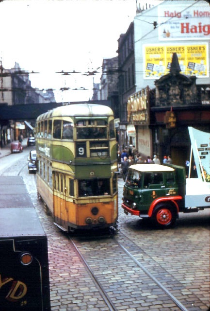
The Modern Tramway Journal of April 1957 included a nostalgic look at one of the Glasgow tram network’s successes. [1] An ‘out-boundary’ route, No. 28, which at one time was part of the longest tram route in the UK, almost 23 miles in length. End to end it was a 2 hour tram journey. At that time, the early 1930s, the route from Renfrew Ferry to Milngavie was numbered 14. “In 1943 it was cut at Spiersbridge and renumbered 28, and on 3rd April 1949, the Glenfield – Cross Stobs section was closed.” [1: p61] The truncated line (No. 28) ran from Renfrew Ferry to Glenfield – a distance of 5.24 miles.
For some general information about Glasgow’s trams, please look towards the end of this article. First, we focus on Line No. 14 which was renumbered 28. …
The route of Line No.14 passed through the following ‘stations’/stops:
Renfrew (Ferry Road, High Street, Paisley Road); Paisley (Renfrew Road, Gilmour Street Station, Causeyside Street, Neilston Road); Barrhead (Cross Arthurlie Street, Main Street, Darnley Road); Nitshill Road; Jenny Lind; Thornliebank Main Street; Mansewood; Pollokshaws Road; Shawlands Cross; Strathbungo; St Andrew’s Cross; Laurieston; Glasgow Bridge; Union Street; Renfield Street; Sauchiehall Street; Cambridge Street; Gartnethill; St George’s Cross; Queen’s Cross; Wyndford; Maryhill (Maryhill Road); Bearsden (Milngavie Road); Milngavie (Main Street). [4]
Line 28 was much reduced in length, as we have noted, it still ran from and to Renfrew Ferry but the locations mentioned by Coonie in his article do not appear in the list above.
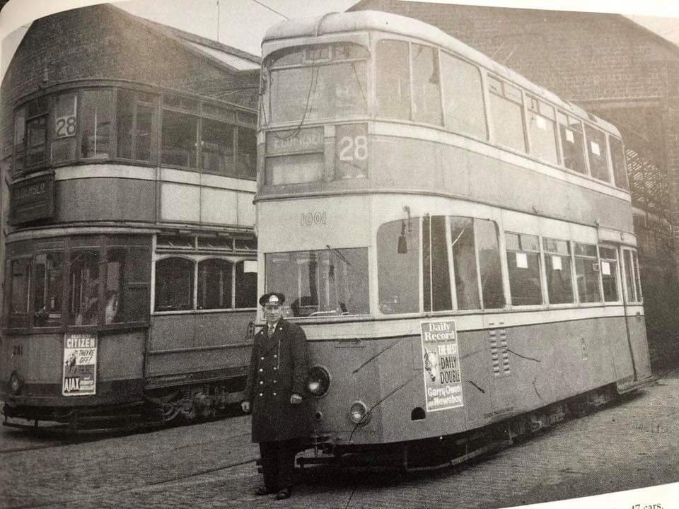
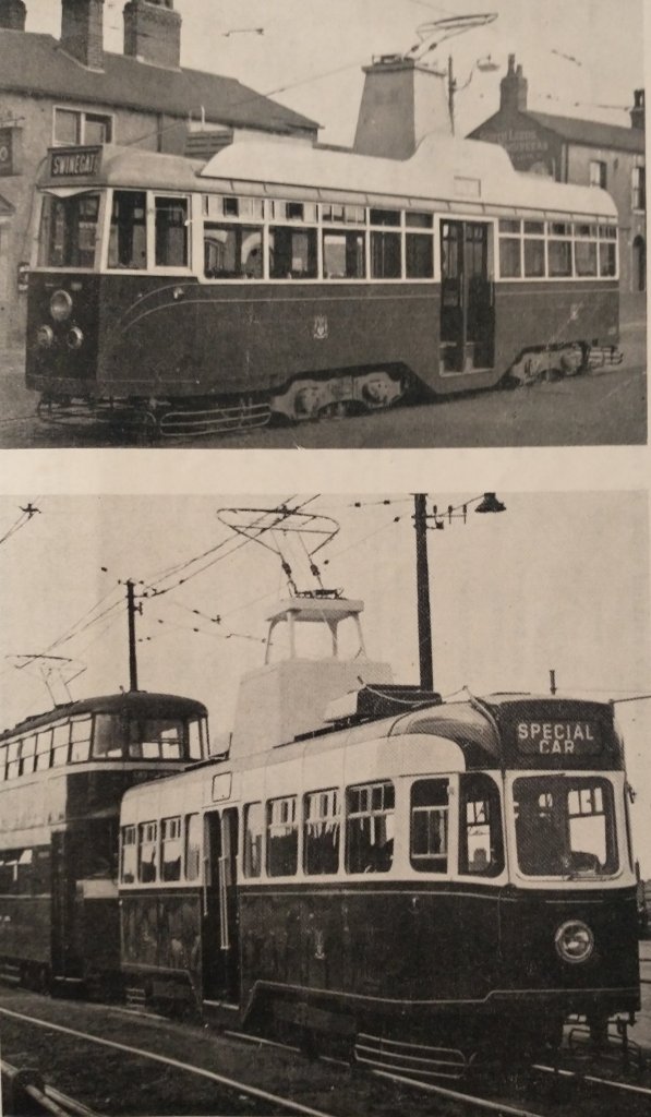
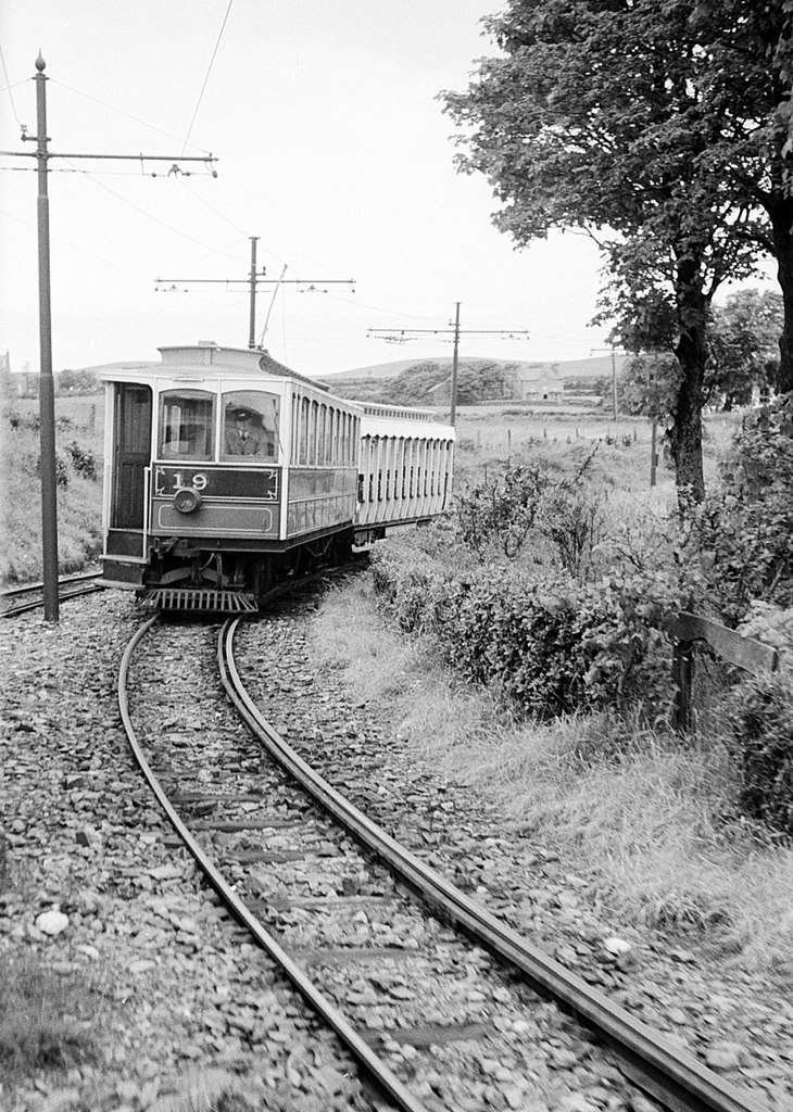
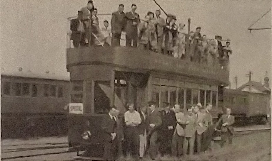
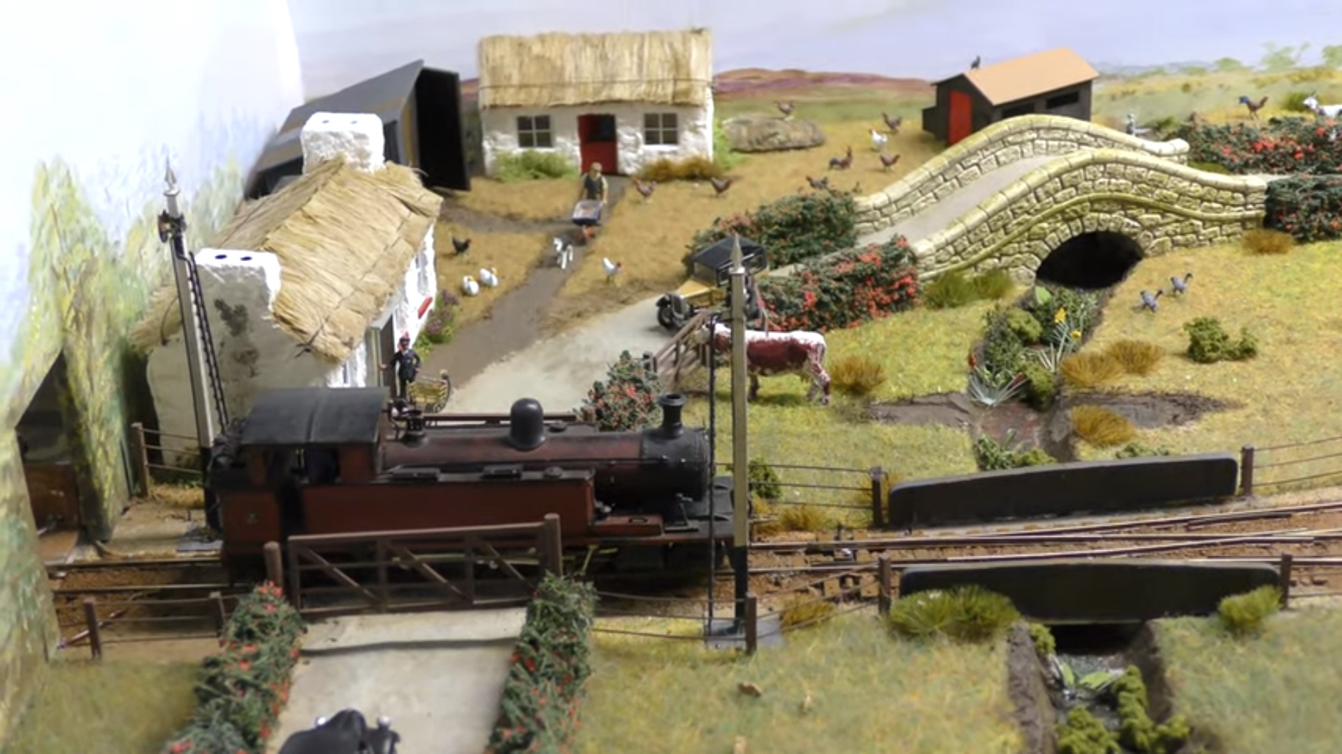
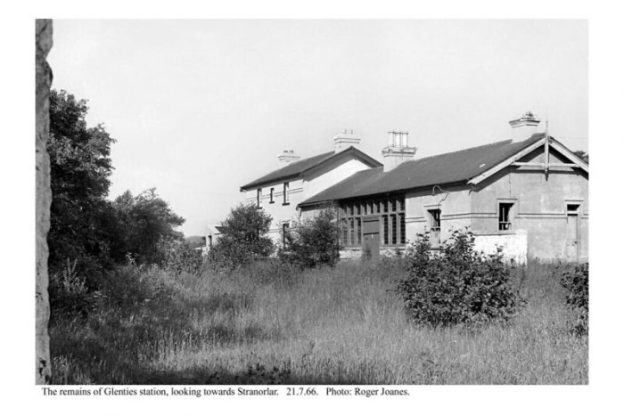
Glenfield Road and Caplethill Road met close to the Glenfield Terminus of the No. 28 route. The image below shows the terminus in use.
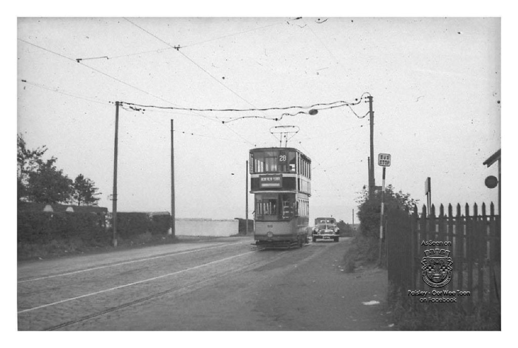
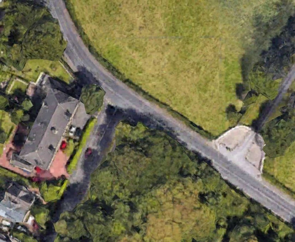
The old No. 14 continued beyond this terminus following Caplethill Road to Barrhead and then left Barrhead along Athurlie Street continuing on through the centre of Glasgow. As you will see below Coonie talks of the Glenfield Terminus being ‘out in the wilds’. [1: p63] Even in 2023 this appears to be the case!
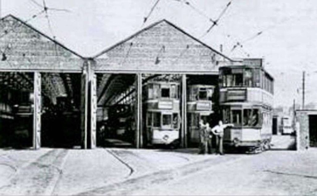
The Elderslie Depot mentioned by Coonie below is, of course, long-gone. Elderslie itself remains, South of the A737 to the West of Paisley and also immediately to the South of the railway line from Paisley to Johnstone. The tram depot was on Main Road, Enderslie. It was opened in 1904 by Paisley District Tramways, it was acquired by Glasgow City Transport in 1923. It was also used as as bus garage between 1932 and 1955 and eventually closed in 1957. The entrance was just before the railway bridge.
The nickname for the No. 28 route was ‘The Goldmine’ as the pence-per-mile average was well above the city average!
In his article, Coonie talks first of the old line (No. 14):
“It is a rare “double-ended” service, taking the crowds both ways at once, shipyard workers to the Clyde, engineering workers to Porterfield Road, shop and office workers into Paisley, factory workers to the south side, workmen’s business and shopping traffic all up and down the same five- mile stretch, with busy two-way peaks but without the awkward tidal traffic flow so common in city transport and yet so uneconomic. Of all the out- boundary routes, the 28 is probably the only one they are sorry to lose; the others lost £80,000 a year, but not the “Goldmine.” It has a history too. In the days of Paisley District Tramways it ran from the Ferry through Renfrew and Paisley burghs to Barrhead and beyond, and after the 1923 take-over Glasgow made it part of Britain’s longest tram route-22.9 miles and two hours, the No. 14 from Renfrew Ferry to Milngavie. … The weekday service is every six minutes (73 before mid-day), with two and three-minute intervals at rush hours and extra cars on Saturdays, so that you get 48 cars in the two-hour morning rush, including ten coming round from Elderslie. There are buses too, for Glasgow Corporation have no monopoly in Paisley or Renfrew and four bus companies are on the same road, red, green and blue- and-white buses racing green-and-orange trams, and most of the buses bought second-hand at that. Patons, Western S.M.T. and Cunninghams run from the Ferry to Paisley, McGills and Western from Paisley to Barrhead, all competing with the trams, … but this is the one place where the trams fought back and held their ground.”
[1: p61-62]
Coonie tells the story of the ‘battle’:
“Up to 1949, Elderslie had only six modern cars (Nos. 1266-1271) and since one of the loops on the Glenfield- Barrhead section was a bit short, only 4-wheel cars were used there. But with that obstacle removed, things be- gan to warm up; the road-widening scheme north of Paisley gave the trams a real speed-track, a new lye at Porter- field Road kept rush-hour cars clear of the main line, a new crossover at Lochfield Road allowed economical short-workings, and then they brought over twelve more Coronations and five modern 4-wheelers from the city to work the base service, kept the old cars on the 21 or in the depot (except at rush hours) and sat back to watch the fun. It was worth watching; the comfort, the headway and the rapid acceleration soon brought passengers back to the trams and kept them, the average speed including stops was 2 m.p.h. above the city’s average, and although the 28 modernisation was expensive, it paid off. The “Goldmine” was a fine example of what you can do with modern trams if you try – even in 1950 – and although the boundary agreement means that its days are numbered now, that’s politics and no fault of the trams.
[1: p62-63]
Most trips are busy and uneventful, with the accent on good timekeeping and good service, but (keep it dark) the “Goldmine Handicap” is still run two or three times a month, depending on the rosters, the weather, and whether anyone is around. My last race was on [Car No.] 1272 just before Christmas, with Dennis up front … We left the Ferry dead on time, but were held at Renfrew Cross, and the pride and joy of Cunningham’s Bus Service (second-hand ex-London R.T. 1481) got away in front, driven by tram-hater Duncan who once called Coronations a “pile of junk.” Dennis decided to show ’em; he opened her up, but passengers were already leaving the tram stop at Robertson Park to get on the bus, which always gets his goat, and with strange oaths, half-Irish, half-Glasgow, he went on gaining ground to Renfrew South. The road widened out; the Coronation was put on the last notch, traction motors whining, lamp-shades swinging, Rosie the clippie squealing ‘Whit ur you playin’ et?’ as we tore up Moorpark, over the hill, down past the boundary sign and round the curve till at Sandyford Fire Station the R.T. gasped and called it a day. Dennis whined past, picked up six passengers, and kept right on at full power to Paisley North, the 17-year-old tram beating London’s wonderful post-war bus as usual. Officially these things don’t happen, and the names in this story are fictitious, but that’s how the insulator suffered at Moorpark.”
Apparently, it was important, if one wanted to make a claim to have done the ‘Goldmine’ properly, to start at Enderslie Depot. Coonie describes the route in detail:
“The cars for [Route No.] 28 are all shedded at Elderslie; Coronations 1266 to 1283, older hex- dash and round-dash cars, and the five single-truck experimentals 1001-4 and No. 6, dating from 1939-41. No. 6 is “The Coffin”; once a standard car, it was destroyed in the Clydeside blitz of March, 1941, rebuilt as a modern car, burnt out at Newlands Depot in 1948, rebuilt, sandwiched between 1280 and 1282 in 1951 and rebuilt again. But ours is flagship 1279, a Phoenix with a 1954 Coronation body, running number eight due out 6.20 am. On the dark winter’s morning, the wind blows across the railway and the jungle that was once a garden, tended by the staff of Paisley District Tramways; we enter the main road, reverse, cross over, and roar down through Paisley and the darkened High Street, picking up the “regulars” for the south side starch and textile-finishing works. At the Cross, the driver changes the points (no points- man till 7 a.m.), then we take the curve into Gilmour Street, and the passengers rise and swing the seats unasked as we reverse in County Square for the ten-minute run south through the waking town to Glenfield.
Glenfield terminus is almost out in the wilds. A few derelict standards remind you that eight years ago you I could travel by a “Saxby” down the narrow country road to Barrhead, with sharp turns into the loops and the power a bit on the weak side, though that didn’t prevent No. 1005 taking a League party down there in 1947. But we turn the seats, wait for a minute and then head north again; down the grade, past the road from Glenburn housing estate whose people are forever complaining at their bus service, up again through Potterhill where the “nobbery” live and, over the goods line at the old Potterhill station. If you look back now, you see the majestic skyline of the Gleniffer Braes, made famous by the Paisley poet Robert Tannahill.
Things begin to warm up now, with customers at every stop. Over Lochfield Road crossover and Neilston Road, we pass Brown and Polson’s cornflower works and the line becomes a real town tramway with tenements, 3-story buildings and the Royal Alexandra Infirmary. The final descent, Causeyside Street, is rather wider, and then we pass a crossover round a curve, and ride up the 1 in 12 St. Mirren Street Brae to stop more often than not at the Paisley Cross traffic lights. Despite the grade there is no record of any tram accident here, though a bus ran away in a heavy frost some years back. Later in the day, at 9 a.m., 12 noon, 3, 6 or 9 p.m. you can hear the carillon of Paisley Town Hall across the garden in Dunn Square, old Scottish tunes with hymn-tunes on Sundays. At Christmas, the square is a fairyland of coloured lights.
The lights change, we rattle over the points and crossings of the 21 route (Paisley’s best-known sound), and pull up in narrow Gilmour Street, the main loading point for the “Goldmine” to Renfrew. On Saturday, the scene in Gilmour Street has to be seen to be believed, with long queues at both north and southbound stops and never a wasted journey. Then we pass Paisley Municipal Buildings and the old jail, all turreted and crenellated like a medieval fortress, facing on County Square and harmonising with the G.P.O. and the railway station built to the same style. There is a crossover, and a small loop, once connected at both ends to the northbound line but now a fossilised remnant; it was once the terminus of the Abbotsinch service worked latterly by oneman single-deck car No. 92 from Finnieston until it closed on 26th March 1933. The loop was still used for short-working 28s until about five years ago.
Under Gilmour Street bridge we turn into Old Sneddon Street, cross the River Cart by Abercorn Bridge and see on our left the red-brick Abercorn Street sub-station of G.C.T., its siding connected to our northbound track by a trailing point. Excluded from the frequency-change scheme, Abercorn Street is the last sub-station working at 25 cycles, and since its closure will complete the change to industrial frequency at Pinkston this explains why the Department are pre- pared to give up serving Paisley. Just past here, a tenement block juts out and causes the track to become single for twenty feet in Weir Street, the only single track on the Glasgow system, and then we turn left into Renfrew Road, pass some engineering works and Paisley (Abercorn) station, and gain the open road again. There are several schools here, and until 1953 a special school car was run from Elderslie.
Next come Sandyford Road crossover (“Paisley North”), the terminus of the long No. 4 from Springburn. At the fringe of the New Gallowhill housing scheme is a small cairn, marking the spot where Marjorie Bruce, mother of Robert the Bruce, was thrown from her horse and fatally injured. In contrast, there is nothing at all to mark the site of Renfrew tram depot at Newmains Road, which was swallowed up completely by a housing scheme in 1949 after being used for 13 years as a store. We are now on a stretch of road which until 1949 was just a dusty cobbled lane with no pavement and the “Saxby” cars brushing the hedges; to-day it is a fine broad tarmac road, on which the Elderslie Coronations and Govan Cunarders can really show their paces. When the road was widened, the track was completely realigned. Beyond, on the right, we can see the runways of Renfrew Airport, and on the skyline the shipyard cranes of the Clyde and the tower of Glasgow University.From here, we climb over the hill and down to Porterfield Road (“Renfrew South” on the screens). One of the sights of the “Goldmine” is the 5.30 p.m. scene on the Porterfield Road lye, a new track (with a double-track triangle junction) put in in 1950 to cater for the Babcock and Wilcox engineering works traffic. As the hour approaches, specials arrive from both north and south, from Elderslie and from Govan, to line up on the works track; then at 5.28 the whistle blows, the crowds stream out to the waiting cars, and from 5.31 to 5.38 a queue of packed special cars moves off nose- to-tail, some for Paisley (Causeyside Street), some to Lochfield Road, and some to take the curve at the Cross for Elderslie. The sight is warmly recommended to all tram-lovers.
Passing the Robertson Park (second finest in Scotland) we reach Renfrew Cross and the turreted Town Hall, six times the height of a tram. Away to the right swing the tracks of the 4 and 27, linking Renfrew with Glasgow via Shieldhall and Govan, and we are on our own again, round a slight curve, under the goods railway and past some shipyards on our right, perhaps with a dredger fitting out. Ahead lies the end of the line, the slipway of Renfrew Ferry, and the towering mass of the Clyde Valley Power Station across the water. Originally the terminus was nearer the ferry gates and consisted of a trailing crossover, but this was cut back to ease congestion in 1954 and replaced by a single line in the middle of the road. The slack wire used to facilitate the bow reversal here is one of the longest on the system.
The car comes to a stand; the crew turn the seats, and the passengers walk down to the diesel-electric chain ferry and float slowly across to where other trams – standards, Coronations, Kilmarnock bogies, and strange beasties like 1809 and 1100 – run up and down between cranes and shipyard walls to Whiteinch, Clydebank and Dalmuir. And as we pay the penny toll to enter Dunbartonshire, we can look back at the grid pylon reflected in the water, to the chain of the ferry vanishing into the depths, and to the Coronation standing in Ferry Road beyond, almost out of sight, waiting for another good payload and another run “Down the Goldmine,” the route where the tram hit back – and won.”
[1: p63-65]

Glasgow Corporation Tramways were formerly one of the largest urban tramway systems in Europe. [2] Over 1000 municipally-owned trams served the city of Glasgow, Scotland, with over 100 route miles (160 route kilometres) by 1922. [3] The system finally closed in 1962 and was the last city tramway in Great Britain (prior to the construction of new systems in the 1990s). [4]
“From a maximum of more than 1,200 trams in 1947, the system was gradually wound down from about 1953 in what proved to be a lingering death.” [8]
Wikipedia tells us that the Glasgow system’s initial network of a few lines expanded greatly in the early years of the 20th century, [5] extending to burghs and rural areas outside the city boundaries which were soon incorporated into it as well as outlying neighbouring towns [6]
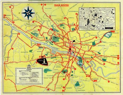

The image above is embedded directly from Flickr. Clicking on this low grade image will take you directly to the image on Flickr. It shows a schematic diagram of the Tramway Network in Glasgow in 1938, © The Magnificent Octopus. [7]
The time of the 1938 Empire Exhibition held in the city’s Bellahouston Park is viewed by some as the apex of the system’s timeline, [6][7] with new cars recently put into service [8] and special routes added for the exhibition, while the city was as yet undisturbed by World War II and subsequent redevelopments, with the trams winding through the dense network of tenements and factories which characterised industrial Glasgow in the first part of the 1900s, [9] but also into some new ‘garden suburb’ developments with widened streets to accommodate the tracks. After the war the trams began to be phased out, although periodic reviews of routes were still conducted. Tellingly, the routes were not extended to any of the large 1950s peripheral housing schemes nor to the new towns being developed outside the city. [4]
References
- Ian M. Coonie; Down the ‘Goldmine’; in The Modern Tramway, The Light Railway Transport League, April 1957, p61-65.
- https://www.scotsman.com/arts-and-culture/scottish-flashback-glasgow-corporation-tramways-1519953, accessed on 29th June 2023.
- https://www.glasgowlife.org.uk/libraries/family-history/stories-and-blogs-from-the-mitchell/times-past-blogs/glasgow-tramways-golden-jubilee-1922-times-past, accessed on 29th June 2023.
- https://en.m.wikipedia.org/wiki/Glasgow_Corporation_Tramways, accessed on 28th June 2023.
- The Glasgow Municipal Tramways System (extracts from The Tramway and Railway World, 7 September 1911) C Glasgow Transport 1871-1973 (archived version, March 2019); https://web.archive.org/web/20190323045631/http://www.semple.biz/glasgow/gcthistory1911.shtml, accessed on 29th June 2023.
- Tram routes, 1938 (Museum of Transport), The Glasgow Story; https://www.theglasgowstory.com/image/?inum=TGSE00122&t=2, accessed on 28th June 2023.
- This stunning map shows just how big Glasgow’s tram network used to be . It was sourced from Glasgow Live, 21 May 2019.
- Ian Stewart; Glasgow ‘a city that loved trams’; BBC News, 4th September 2012; https://www.bbc.co.uk/news/uk-scotland-glasgow-west-19474957, accessed on 29th June 2023.
- No Mean City: 1914 to 1950s – Everyday Life, The Glasgow Story; https://www.theglasgowstory.com/story/?id=TGSEA, accessed on 29th June 2023.
- https://m.facebook.com/paisleyoorweetoon/photos/a.300846973361677/947838858662482/?type=3, accessed on 29th June 2023.
- https://m.facebook.com/190989774408411/posts/elderslie-tram-depot-the-location-of-the-tram-depot-in-main-road-elderslie-opene/1483987731775269/#, accessed on 29th June 2023.


