Category Archives: British Isles – Railways and Tramways

The Ballachulish Railway Line – Part 2

In Part 1 we covered much about the history of the line between Connel Ferry and Ballachulish. We start Part 2 with a few reminders of what was covered in Part 1 and provide some additional material from various sources before continuing our journey North along the branch.

Several sea lochs made road travel between Oban and Fort William difficult, and Argyll County Council had indicated that it would co-operate with the Callandar & Oban Railway (C&OR) if the railway were to build dual-use bridges; the C&OR was considering an ambitious railway from Oban to Inverness by way of Fort William. The C&OR decided to decline the idea, and to make the railway on its own, and to undertake the work it itself. The C&OR had difficulty in raising enough money for a survey of the proposed line, but undaunted, it presented a Parliamentary Bill for the line in September 1894, for the following year’s session. [1]

The C&OR made this move without consulting with its parent company, the Caledonian Railway (CR). When the CR heard of the plan, they announced that they would oppose the Bill in Parliament. The Bill was swiftly withdrawn. [1]

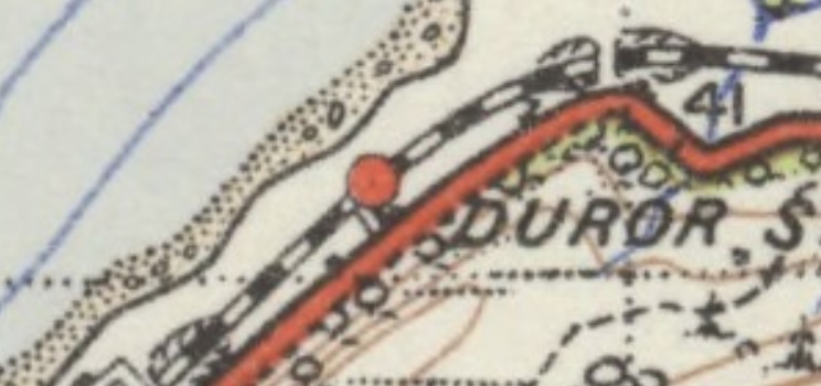
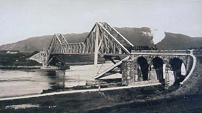
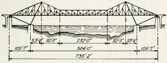
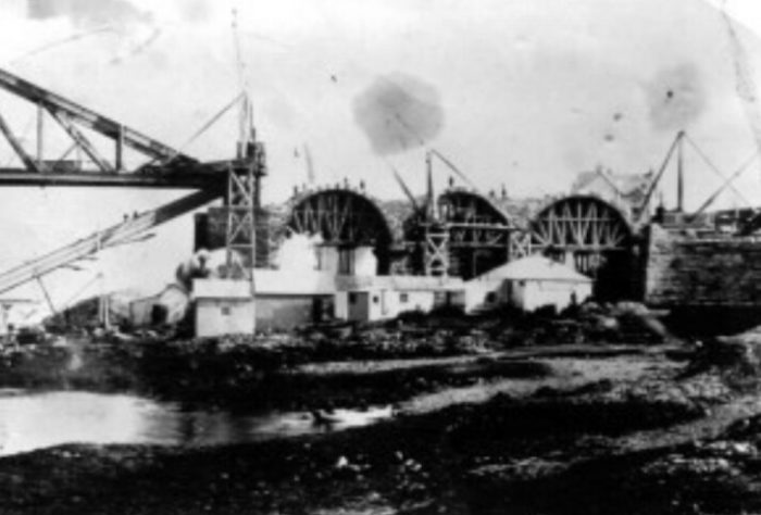
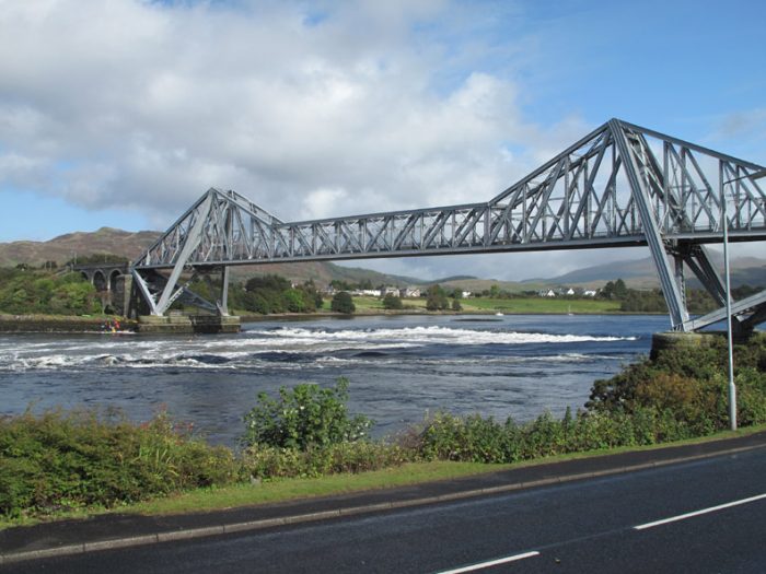
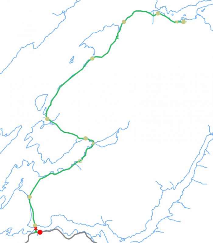
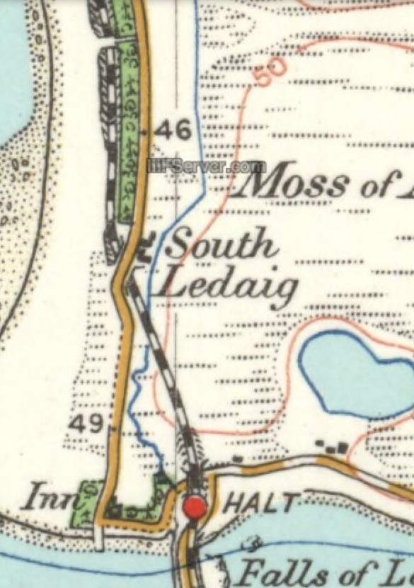
The C&OR converted their proposal into a branch line to Ballachulish from Connel Ferry. Ballachulish had a population of 1,800 at the time, and its industry was chiefly quarrying. The branch was authorised by Act of Parliament on 7 August 1896. [3] The C&OR line was to have a triangular junction a Connel Ferry, and to cross Loch Etive by Connel Bridge which was second in Britain only to the Forth Bridge in the length of the main span, and it was the largest single-span steel bridge in Britain. [5] The route approved north of the bridge was later changed substantially, a hotel had been built at Loch Creran to serve a proposed station there; the hotel was never opened as the railway as built did not go there. The capital was to be £210,000 of which the Caledonian Railway agreed to fund £15,000. [5]

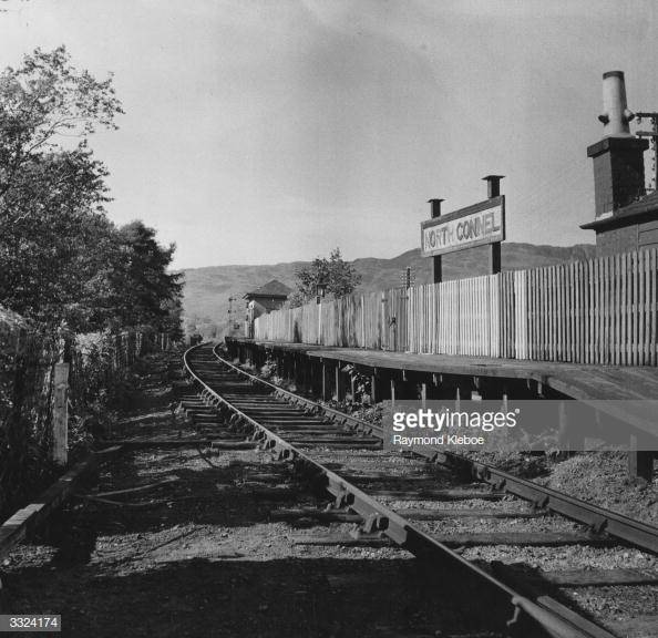
The Route North from Benderloch

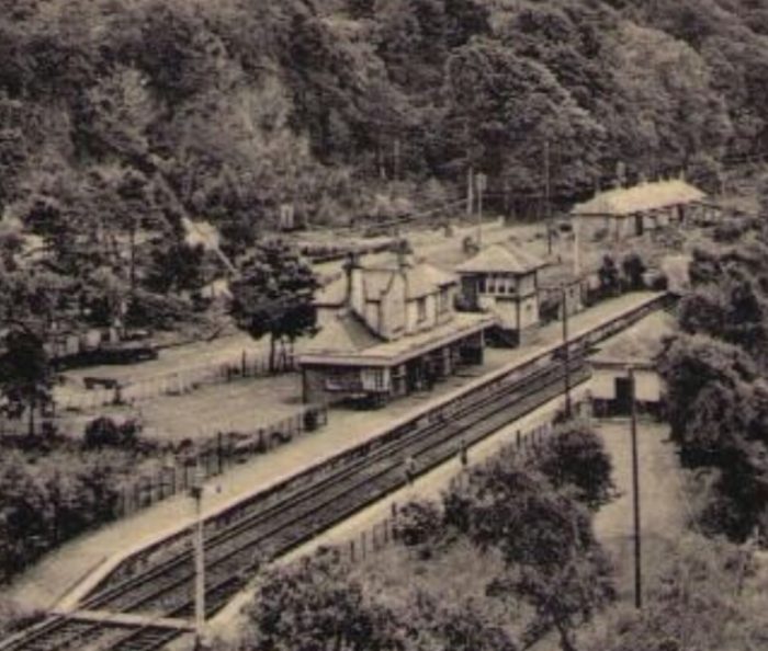
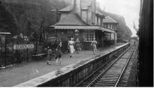
In Part 1 of this survey we travelled as far North as Benderloch. We saw at Benderloch a station very typical of the branch line with buildings (now long-gone) which matched those at other stations on the line.

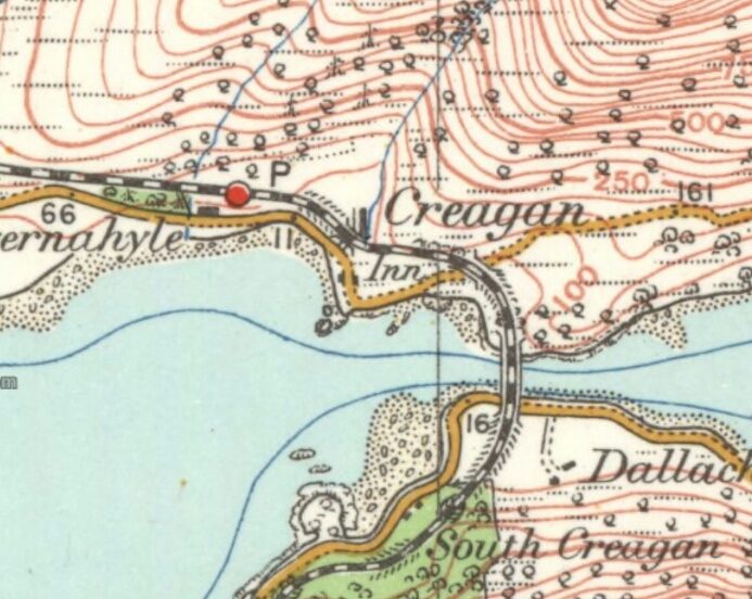
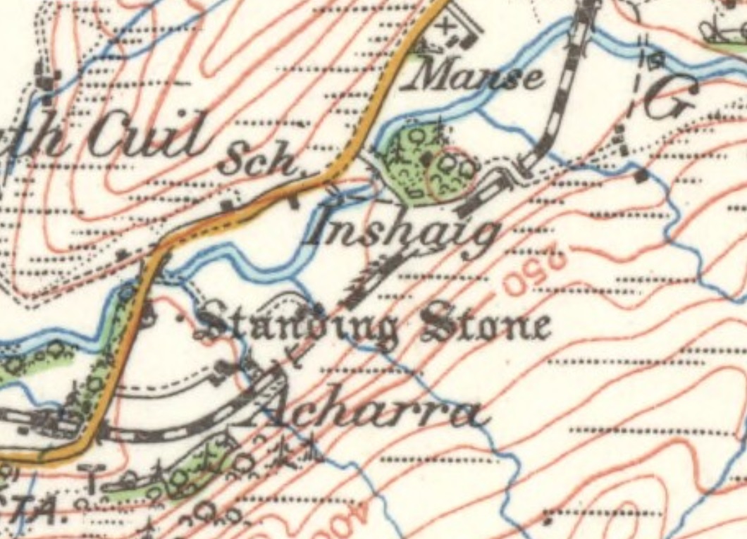
Leaving Benderloch the railway and the A828 ran closely parallel to each other with the railway running closest to the loch shore. This continued until the railway approached the location of Barcaldine House.


The extract from the OS Map above shows the road turning inland at this point and crossing two rivers. The first is Death Abhainn, the second is Abhainn Teithil. The two rivers have over time created a small area of open land at the loch-side which the road avoided. The railway maintained a straighter route and was carried over each of the rivers on bridges.

Barcaldine Halt opened to passengers in 1914. It comprised a single platform on the east side of the line. A siding was installed at the same time, to the south of the platform. [9]

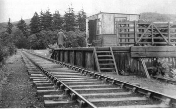
Barcaldine Halt in 1950. [8]

Incidentally, a search for Barcaldine on the internet produces some very interesting information about railways and tramways in Queensland, Australia. Something for another time!

I have recently received the next two images from Tony Jervis -the first is taken from a train passing through Barcaldine Halt. The second is a ticket for the journey from the Halt to Connel Ferry.

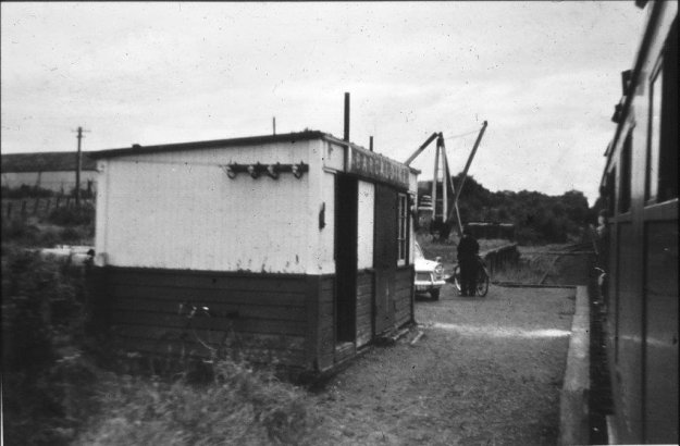
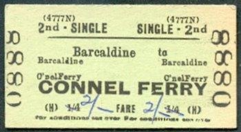
Tony comments: “The railway ticket was probably sold at Connel Ferry Station; if someone has list of station Audit numbers, 4777N against that station should confirm it. The train had just deposited the man and his bicycle.” [22]

Travelling on from Barcaldine, the A828 and the railway swapped places and the railway too a very slightly more inland trajectory and began to rise to a height which would allow it to cross the next loch – Loch Creran. The A828 was forced to take a detour to the East to follow the shore of the loch. The railway took the more direct route.


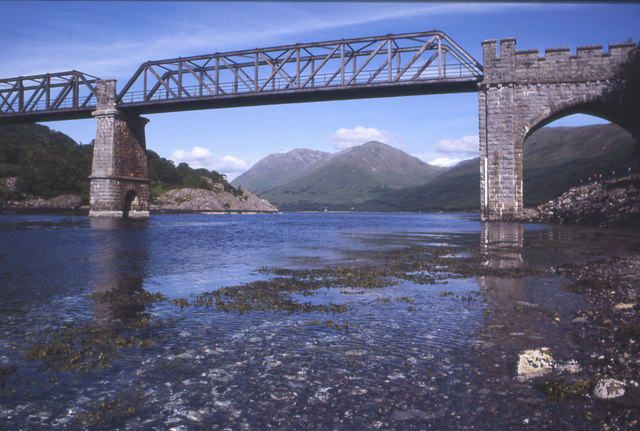
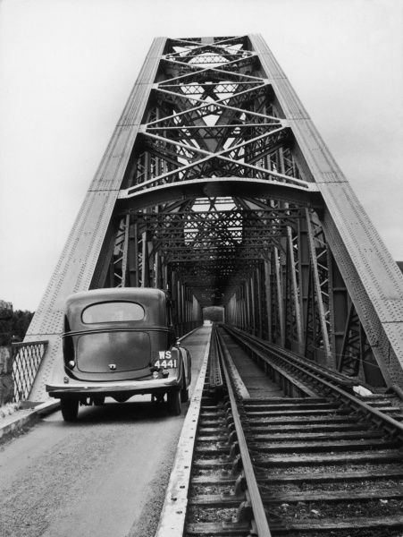
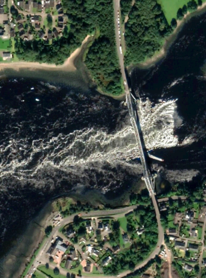
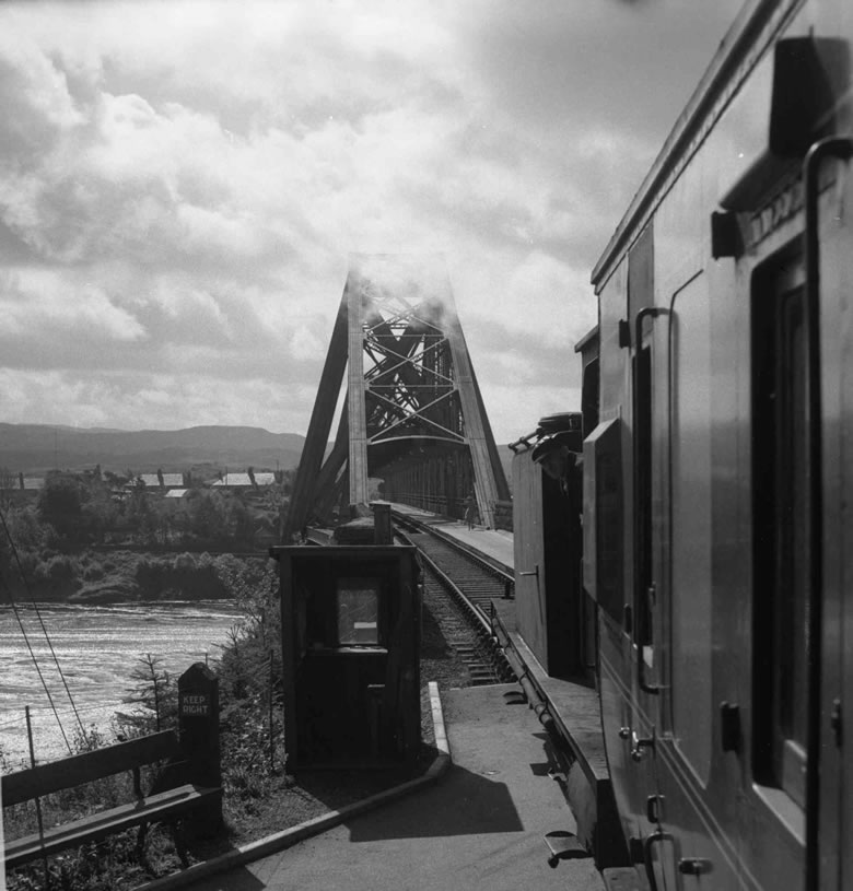
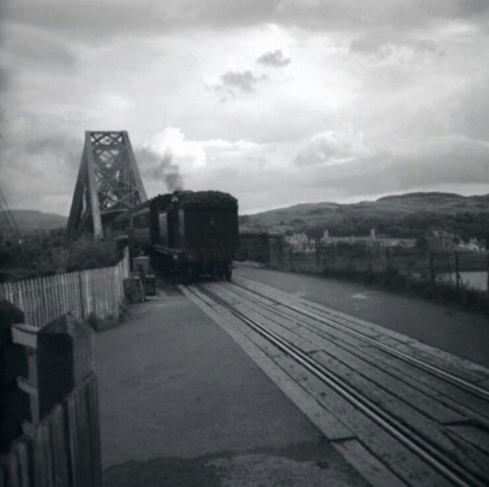
It crossed the loch at the narrowest point on a high level, Howe Truss Girder bridge. When the railway closed, the bridge remained as a pedestrian/cycle route until its foundations were used to divert the A828.

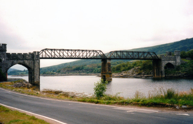
Creagan Bridge from the East, taken after closure of the railway line. [10]

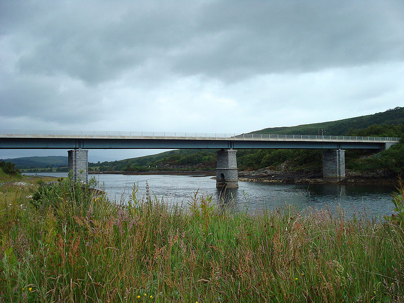
The new bridge. The picture was taken in 2008 by Jack Russell from a very similar location to the one above. As can be seen, the new bridge made use of the foundations and lower piers of the previous railway structure. [11]

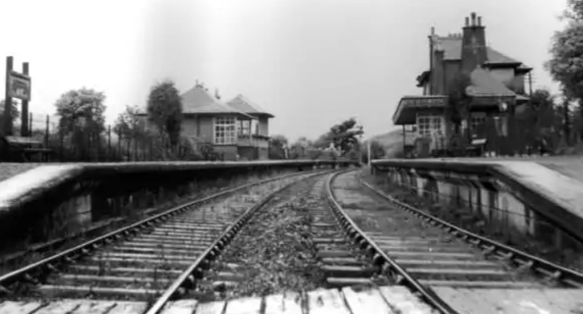
Creagan Station was then approached from the EastEast, as the railway turned westward along the loch-side. The railway ran on the north side of the A828. Creagan Station was the only station on the Ballachulish branch that had an island platform. There was a siding to the east of the platform, on the north side of the railway.

One platform was taken out of use on 1 April 1927. [12]

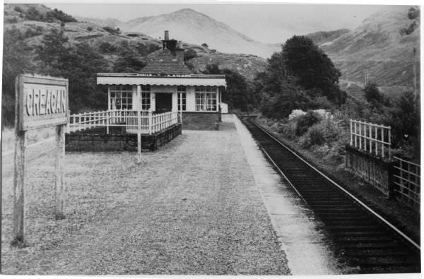
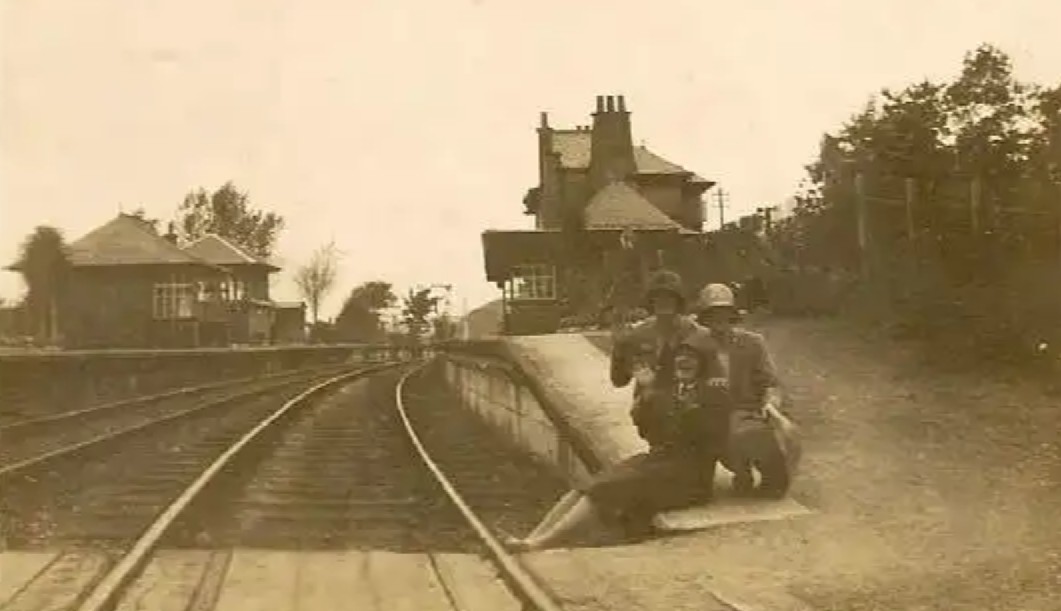
The station at Creagan when still in use. [8]

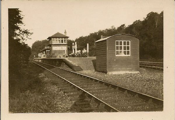
An earlier image of the station, taken when both lines were in use. [8]

The island platform building at Creagan in the 21st century. [12]

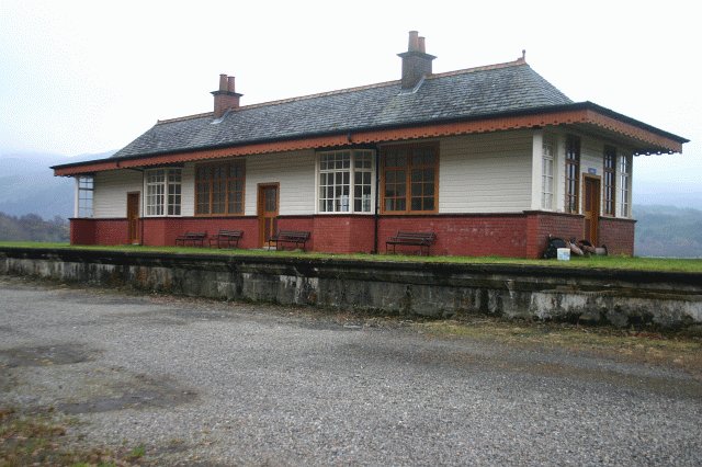
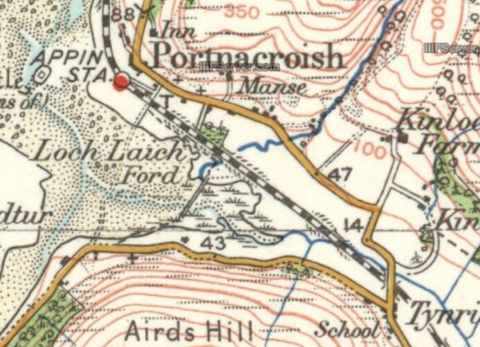
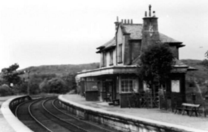
The line continued West from Creagan through the Strath of Appin to Appin Station, by which time the railway was beginning to turn to the North.

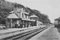
Appin Station was once again typical of the stations on the route. The station building was a substantial two story structure of the same design as elsewhere. The station was laid out with two platforms, one on either side of a crossing loop. There were sidings on both sides of the line. A camping coach was sited here for a number of years.

Appin Station building. [8]

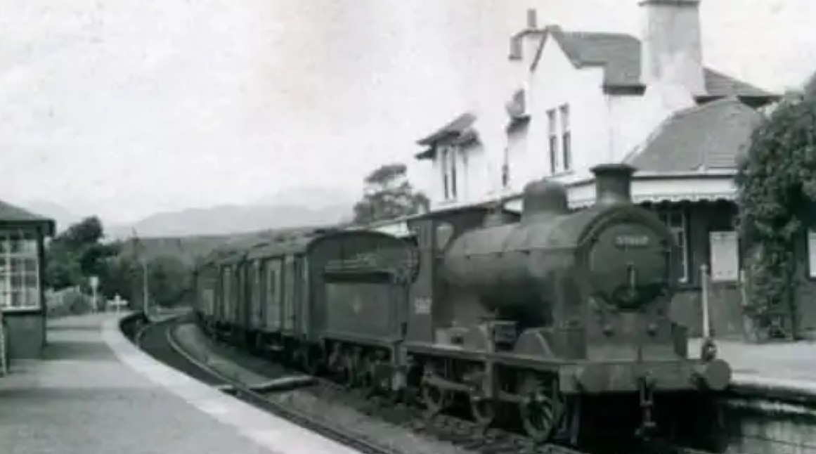
Branch goods at Appin. [8]

Two passenger trains pass at Appin. The camping coach is just visible on the right of the picture. [8]

1920s view of Appin Station. [8]

A similar view in the 1950s. [8]

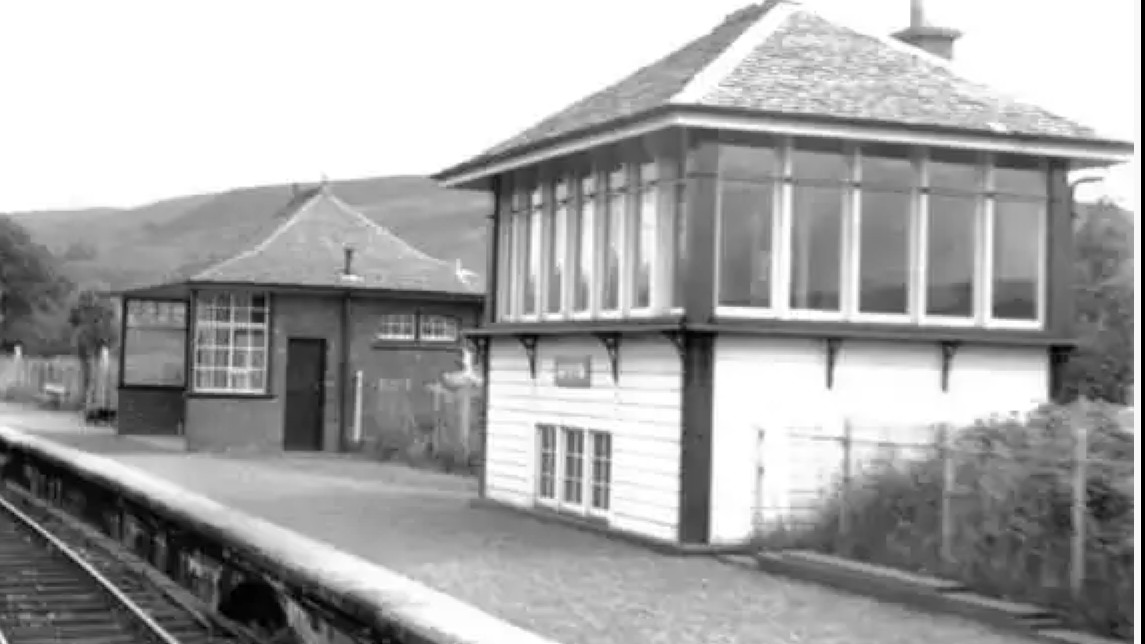
Appin Station Signal Box. [8]

The service from Ballachulish in the later years of the line. [8]

Heading out of Appin Station towards Ballachulish, the line travels Northeast along the coastline. The A828 runs alongside the railway on the landward side all the way to Duror Station.

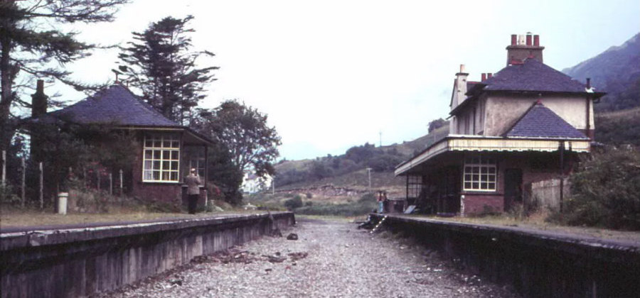
The next two images below show Duror Station while it was still in use for its intended purpose. The signal box can be seen beyond the main station building.

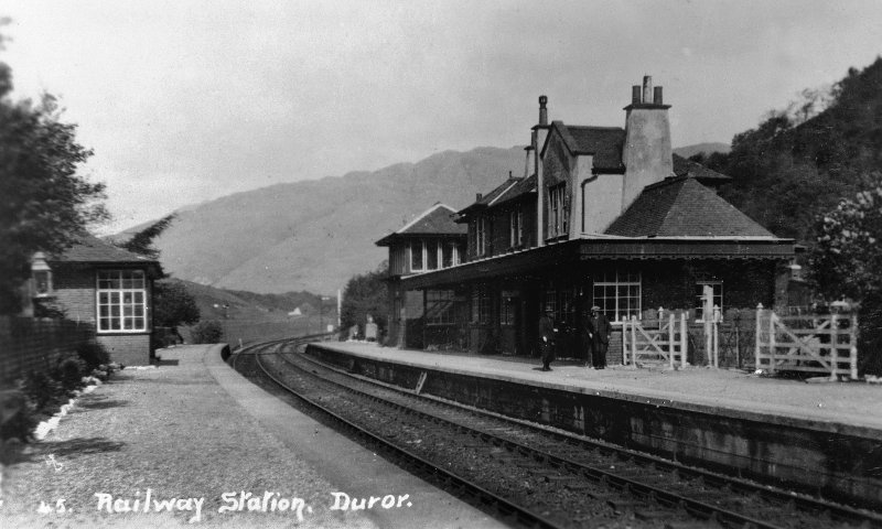
Duror Railway Station. [15]

Duror Station after the closure of the loop. [16]
The station was laid out with two platforms, one on either side of a crossing loop. There was a siding to the north of the station, on the east side of the line. One platform was taken out of use on 8th April 1927 along with the crossing loop.

The station building at Duror is still standing and is a well-maintained private house. The pictures immediately below show the property taken from its access road. The station building remains almost intact, as do the platforms which lie within the garden of the private property. These are also shown below.

Google Streetview Image.

Another view of the station (c) Nigel Thompson. [17]

The station platforms in the 21st century. [16]
The line turned East for a short distance beyond Duror Station, and then turned to the Northeast. Its route is shown on the 1940s OS Map below and as a dismantled railway on the later OS Map below. On that map, Duror Station site is marked with a yellow flag.

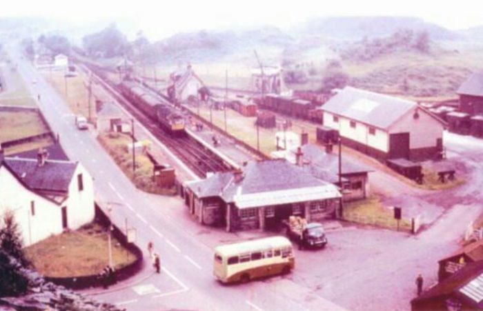
The route North-east from Duoro took trains through a narrow valley hidden away from Loch Linnhe which brought the line and the A828 down to Kentallen and Kentallen Bay. The village was at the head of the bay, its station some distance to the North-east. By the time the station was reached the railway was on the seaward side of the A828.


The station was laid out with two platforms, one on either side of a crossing loop. Alongside the station was a pier from which interconnecting steamers operated. The main station building was on the southbound platform and still stands in much extended form. There was a goods yard at the north end, on the east side of the line. There was a smaller shelter on the northbound platform. The pier survives, in cut back form.

To the south of the station site, and across the road, are railway cottages and the former water tank.

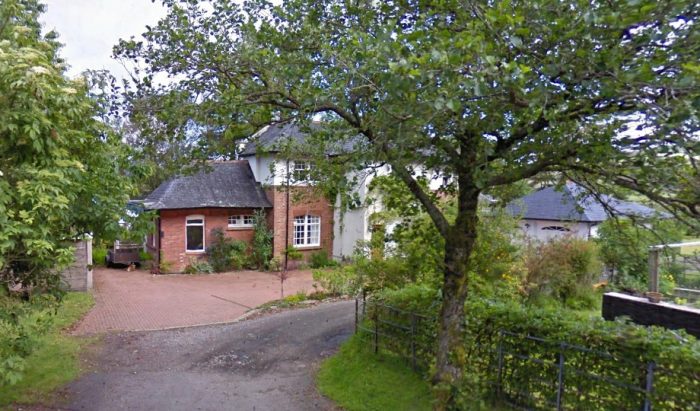
Following closure in 1966, the station buildings were enlarged and converted into a hotel and restaurant.

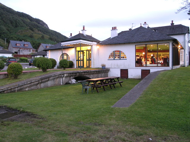
Holly Tree Hotel and Restaurant on the site of Kentallen Station in 2005. [18]

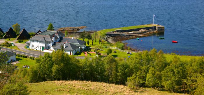
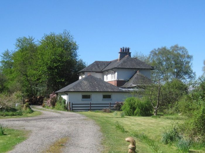
The Hotel from above on the hillside. [19]

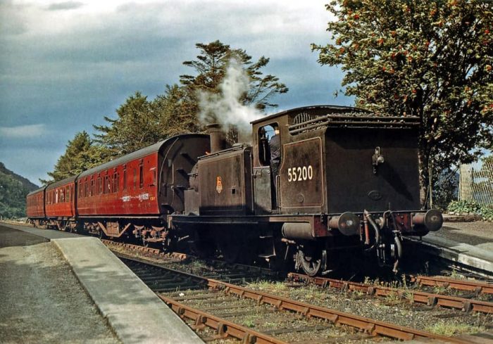
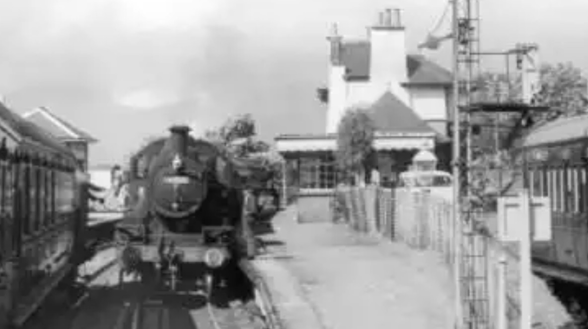
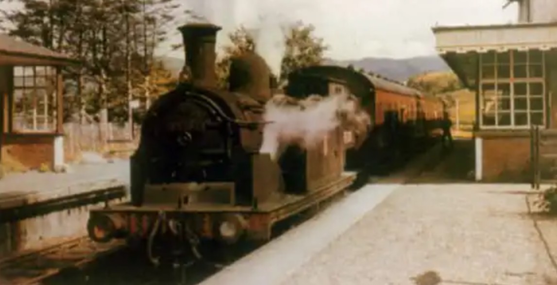
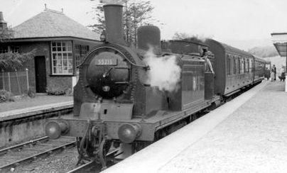
July, 1959. Ex-Caledonian Railway 439 Class (LMSR Class 2P) 0-4-4T No. 55200 stands at Kentallen Station with an Oban to Ballachulish train, (c) Keith R. Pirt. [21]

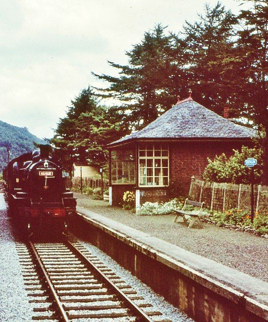
A steam train at Kentallen shortly before the line closed in 1966. [20]

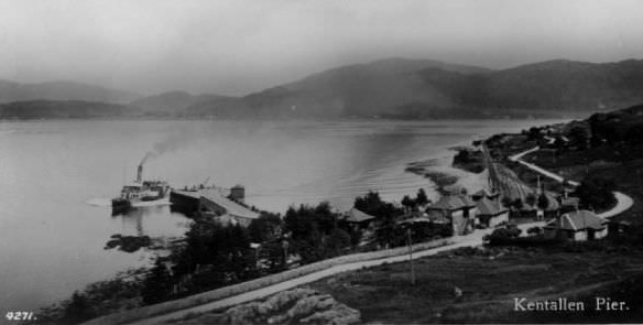
Kentallen Station and Pier. [8]

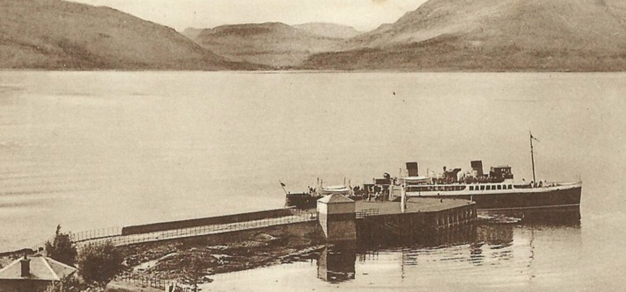
Kentallen Pier. [13]

We have noted that train times and ferry times were designed to allow connections to be made between the station and the pier at Kentallen. The two pictures above show the pier in use by ferries. The ferry timetable is shown below:

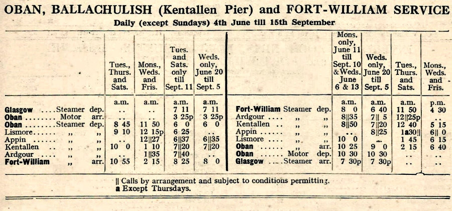
The Oban to Fort William Ferry timetable. [13]

The ferry made travel between Oban and Fort William manageable with a significant road journey. The stop at Kentallen allowed a combined train and ferry journey to be made.

To finish this post and before moving on towards Ballachulish we look at a few period images of Kentallen Station.

The station immediately after closure and before conversion to a hotel commenced. [13]

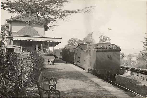
Pick-up goods heading south through Kentallen. [13]

The local passenger service heading south through Kentallen. [14]

I had originally expect that there would be just one post relating to the Ballachulish line but the material has been mounting up and I have now (January 2018) discovered an article from November 1950 in “The Railway Magazine” which means that a third post is warranted. We finish this part of the journey at Kentallen and will commence again from here to complete the journey to Ballachulish in part three of the story of the line.

References

  1. https://en.m.wikipedia.org/wiki/Callander_and_Oban_Railway, accessed on 1st January 2019.
  2. https://en.m.wikipedia.org/wiki/Ballachulish_railway_station, accessed on 1st January 2019
  3. E F Carter, An Historical Geography of the Railways of the British Isles, Cassell, London, 1959
  4. http://www.rmweb.co.uk/community/index.php?/topic/126169-appin-station, accessed on 2nd January 2019.
  5. David Ross, The Caledonian: Scotland’s Imperial Railway: A History, Stenlake Publishing Limited, Catrine, 2014.
  6. R. V. J. Butt; The Directory of Railway Stations: details every public and private passenger station, halt, platform and stopping place, past and present (1st ed.). Sparkford: Patrick Stephens Ltd., 1995, p23.
  7. Table 33, British Railways, Passenger Services Scotland summer 1962, quoted in https://en.m.wikipedia.org/wiki/Ballachulish_railway_station, accessed on 1st January 2019.
  8. http://oldappin.com/ballachulish-railway-line, accessed on 26th December 2018.
  9. https://en.m.wikipedia.org/wiki/Barcaldine_railway_station, accessed on 2nd January 2019.
  10. https://www.geograph.org.uk/photo/3213543, accessed on 2nd January 2019.
  11. https://www.sabre-roads.org.uk/wiki/index.php?title=File:A828_Creagan_Bridge_-_Coppermine_-_18816.jpg, accessed on 2nd January 2019.
  12. https://en.m.wikipedia.org/wiki/Creagan_railway_station, accessed on 2nd January 2019.
  13. https://hollytreehotel.co.uk/facilities/history, accessed on 5th January 2019.
  14. https://www.pinterest.at/amp/pin/510666045218505803, accessed on 5th January 2019.
  15. https://canmore.org.uk/site/106021/duror-station, accessed on 3rd January 2019.
  16. https://railscot.co.uk/img/9/766, accessed on 3rd January 2019.
  17. https://www.geograph.org.uk/photo/5394443, accessed on 3rd January 2019.
  18. https://en.wikipedia.org/wiki/Kentallen_railway_station#/media/File:Kentallen_railway_station_in_2005.jpg, accessed on 4th January 2019.
  19. https://hollytreehotel.co.uk/about-area/station, accessed on 4th January 2019.
  20. https://www.geograph.org.uk/photo/3027899, accessed on 4th January 2019.
  21. https://www.facebook.com/groups/ScottishRailways/search/?query=galloway&epa=SEARCH_BOX, accessed on 6th June 2019.
  22. Email from Tony Jervis on 15th May 2021.

The Ballachulish Railway Line – Part 1

An old copy of Hornby Magazine fell open at a modelling idea – the creation of a model representing the Ballachulish line in Western Scotland. Having walked a length of this line in the past, the article grabbed my attention and prompted some research. [1]

Ballachulish Railway Station.[4]

Ballachulish is a village at the foot of Glencoe in the Scottish Highlands. Glencoe is a deep valley which forms the natural road route into this remote part of Scotland. During the Victorian era it’s transport links centred around a steamer connection with Fort William, about 15 miles North, and Oban, a little further in a southerly direction.

Despite its remote location, Ballachulish had extensive slate quarries and during the 1880s it was hoped that local interest would be served by a railway line from Crianlarich up Glencoe and on to Fort William. This was not to be. The Rannoch Moor route was chosen instead. Other lines, such as an Oban to Fort William Railway failed to materialise.

Instead, rather late in the day in 1896, a branch line was authorised from the Oban-Crainlarich line at Connel Ferry. It was hoped that this would meet a similar line from Fort William but, although powers were obtained, it was never built because of problems gaining permission for bridges across sea lochs. [1]

Ballachulish

Ballachulish is a slightly confusing place. It’s not unusual to find places that come in two halves. But Ballachulish comes in two halves plus another, larger, settlement two miles along the road towards Glencoe.

The name comes from the Gaelic for village of the narrows, and the first settlement to bear the name lay where North Ballachulish is today. Its twin, on the south side of the loch, rapidly followed. Loch Leven narrows dramatically here and North and South Ballachulish grew up around the slipways used by ferries crossing the loch from a very early date. A vehicle ferry started to cross the narrows in 1912, but the service finally disappeared in 1975 when the bridge opened. With it disappeared the choice facing drivers of the sometimes long ferry queues at busy periods or the nineteen mile detour via Kinlochleven.

While the ferry has long gone, the slipways that served the ferry remain: though they are by no means opposite one another. The steel truss bridge that opened here in 1975 fits nicely into its environment. Indeed, it comes as something of a surprise to find it is such a relatively recent addition to this part of the Western Highlands.

South Ballachulish largely comprises the slipway and the nearby Ballachulish Hotel. Close to the steps leading down from the bridge to the Oban road near the hotel is a memorial to James Stewart, hanged here in 1752 for the Appin Murder. This was the killing of Colin Campbell, an event used as the basis for Robert Louis Stevenson’s novel Kidnapped. Stewart’s execution was a result of the greatest miscarriage of justice in Scottish legal history. A number of the sites associated with the Appin Murder have been linked by the Last Clansman Trail.[2]

Ballachulish Bridge should not be confused with the Connel Ferry bridge closer to Oban.

North Ballachulish is a little more developed and is home to an art gallery, lochside hotel and the slipway for the old ferry.

The largest settlement carrying the name of Ballachulish lies on the south side of Loch Leven, a mile or so west of the village of Glencoe. This started life as the hamlets of East and West Laroch in the 1500s, names still attaching to parts of the village on detailed Ordnance Survey maps. In 1693, slate was first quarried here in the Ballachulish Slate Quarries (only a year after the Glencoe massacre took place nearby). By the early 1700s, this had developed into a major slate quarrying operation which continued for over 250 years until 1955, when the quarries closed. The name of Ballachulish simply seems to have attached itself to the larger village that grew out of the earlier settlements to house the 300 workers and their families.
The Ballachulish Medical Practice today stands on the site of the railway station that formed the terminus of a branch line railway running from Connel via Ballachulish Ferry. This opened in 1903 and closed in 1966. Ballachulish now has its own Visitor Centre, which comes complete with ample parking and public conveniences. Just across the road from the visitor centre are the old Ballachulish slate quarries, which now provide scenic walks. There’s no mistaking what they are, but in the half century since they closed, nature has made a start on the task of reclaiming what was once taken from it. The main settlement of Ballachulish is now largely bypassed by the A82, which passes along the Loch Leven side of the village. [2]

The Railway
Construction work on the line started in 1898 and was completed in 1903. This was one of the last branch lines to be built in the UK. [1] The following notes in italics are taken from an on-line article published on the website “Unseen Steam” on the 50th Anniversary of the closure of the line in March 2016. [5] Images used are credited where possible and taken from a variety of sources.

The authorised capital of the new line was £210,000, of which the Caledonian Railway agreed to fund £15,000. There were two major engineering structures required: the viaducts over Loch Etive and Loch Creran at Creagan. The former, constructed by the Arrol Bridge & Roofing Co, was started in 1898. The cantilever bridge that resulted was the second only in length to the Forth Bridge and was the longest steel single-span bridge in Britain.

Construction Drawing – Connel Bridge. [8]

Connel Bridge under construction. [4]

Connel Bridge under construction. [4]

Connel Bridge. [7]

Creagan Railway Bridge, Loch Creran. [6]

The Connel Ferry Bridge, the world’s 2nd largest steel cantilever bridge, Argyllshire, Scotland, opened in 1903. [9]


Although a triangular junction was authorised at Connel Ferry to permit direct Oban-Ballachulish services, in the event the north-west curve was never constructed. Originally both the viaducts had footpaths alongside; however, in order to counter a proposal by MacAlpine Downie to operate a ferry across Loch Etive in 1913, the Callendar &Oban Railway decided to make the railway bridge capable of handling road traffic. This was completed in June 1914 and saw the railway charge tolls for road users crossing the bridge; special signalling ensure the safety of the arrangement.

The 27½-mile long branch opened throughout to passenger services on 28 March 1903. There were intermediate stations at North Connel, Benderloch, Creagan, Appin, Duror, Kentallan and Ballachulish Ferry that opened with the line. Barcaldine Siding (Halt from 1960) followed in 1914; this station was closed during World War 2 and was used for summer services only for a period after reopening postwar. Ballachulish Ferry was to be closed between 1 January 1917 and 1 March 1919 as an economy measure during World War 1. The population of Ballachulish when the line opened was less than 2,000 but quarried stone represented a useful source of freight traffic.

During the summer of 1910 there were three return workings over the branch each day, making a connection with the ferry to and from Kinlochleven. Services ran to and from Oban, with reversal at Connel Ferry. Down services departed from Oban at 8.20am, 11am, 5pm (Mondays, Wednesdays and Fridays only) and 8.30pm (Tuesdays, Thursdays and Saturdays only; this was the only working that did not connect with the Kinlochleven ferry). Up workings departed at 7.15am, 11.15am and 3.45pm. A single journey from Connel Ferry to Ballachulish took about 70 minutes. There was no service on Sundays.

By the summer of 1947, the final year of the line’s operation by the LMS before Nationalisation in January 1948, there were still only three return workings per weekdays. Departures from Oban were at 8.10am, 12.5pm, 4.pm (except Saturdays) and 8.50pm (Saturdays only). Services departed from Ballachulish at 7.30am, 10.50am, 3.50pm (Saturdays only) and 4pm (except Saturdays). There was no Sunday service. A revised pattern of service was operated by British Railways (Scottish Region) during the period from September 1964 through to June 1965. There were two down departures from Oban, departing at 8.15am and 5pm with a third service starting at Connel Ferry at 12.30pm. The station at North Connel was a request halt for both the 8.15am and 12.30pm services. In the up direction there were departures from Ballachulish at 7.14am (to Oban), 10.40am (to Connel Ferry), 4.20pm (to Oban) and a Saturdays only 6.57pm (to Oban). For all, apart from the 7.14am, the station at North Connel was a request halt.

In terms of motive power over the line, the early years witnessed the operation of three generation of 4-4-0s specifically designed for the C&OR — the ‘Oban bogies’. During the war Class 5 4-6-0s are known to have operated troop trains to Benderloch. In the later years, steam passenger services were dominated by Macintosh-designed ‘19’ class 0-4-4Ts. By the end of 1961, three of the class were based at Oban — Nos 55204/217/260 — but before the final demise of steam over the branch, these were replaced by ex-LMS or BR 2-6-0s. With the dieselisation of the C&OR main line and its branches to Killin and Ballachulish, 45 steam locomotives were replaced by 23 Type 2 diesel-electrics plus four diesel shunters. It was the diesel-electrics that operated the final passenger services over the line to Ballachulish.

Whilst both the Crianlarich-Oban and Crianlarich-Fort William-Mallaig lines were not listed for closure under the Beeching Report of March 1963 — albeit a number of intermediate stations on the former were — the line to Ballachulish was not so fortunate. Passenger traffic ceased over the on 28 March 1966; with freight having ceased in June the previous year, the line was closed completely from that date.

Today many of the structures that once served the line are still extant or have been reused for new purposes. The station at Ballachulish remains, having been converted into a medical centre. Platforms remain extant at Ballachulish Ferry with a section of the line westward having been converted by Sustrans into a cycleway. At Kentallen, the platforms of the station have been incorporated into a new hotel. At Duror, the station has been converted into a private house. The station at Creagan, which was overgrown for many years, has now been restored. The piers of the bridge across Loch Creran at Creagan remain, having been used in the late 1990s for a new bridge for the A828. The bridge at Connel Ferry also survives; following the closure of the line it was converted to take road traffic exclusively. [5]

The Route of the Ballachuliush Branch. [3]

The Connel Bridge

The red ‘x’ on the plan above marks the Connel Bridge which sits just to the north of the Calendar to Oban line. The bridge was the largest cantilever span in Great Britain aside from the Forth Bridge when completed. A truly unique bridge, it features several members positioned in unusual angles and inclines, resulting in a striking appearance that looks ahead of its time and may even call to mind images of modern cable-stayed and steel rigid-frame bridges.
The bridge was originally built as a single-track railway bridge to carry the Callander and Oban Railway. In 1909, a special railway service was added that carried motor vehicles across the bridge, albeit only one car at a time. This unusual arrangement did not last long, however. By 1914, the bridge was reconfigured with a roadway along the western side of the deck and the railway on the east side of the deck. Despite this arrangement, the relatively narrow width of the bridge prevented cars and trains from crossing the bridge at the same time. When a train needed to cross the bridge, the crossing was treated like a grade crossing, with gates to keep cars off the bridge. In 1966, the railway line was closed and bridge was reconfigured as a highway-only bridge, with the rails being removed. The narrow bridge operates as a one-lane bridge, with traffic signals controlling the flow of traffic over the bridge. [8]

The distinctive design of the cantilever truss is due to the configuration of the trusses over the piers. Typically, cantilever trusses have a vertical post, sometimes called the “main post,” located directly over the pier that is also at the deepest section of the truss web. For the Connel Bridge, these posts are instead inclined, not only inward toward the center of the span, but also inward toward the centre of the roadway. As such, the inclined main posts extend out beyond the truss lines to the pier below, giving the bridge a bowed out appearance when viewed from certain angles. The inclined posts also mean that the deepest “tower” section of the truss is located not over the pier, but partway into the central span of the truss. [8]

The inclined main post is countered by what engineering periodicals described as a “back strut” extending from the bearing on the piers back to the abutment at the roadway level. The back struts angle out to meet the main post locations outside of the truss lines, adding to the bowed out appearance of the bridge. The end post of the truss, also inclined, extends all the way to the main post of the truss, meaning there is no upper chord for this entire length, an unusual design that gives the bridge a striking appearance when approached on the road. If the end post, the main post, and the back strut at each end of the bridge are looked at as a single shape, the bridge has the appearance of two giant triangles resting on their apex at the piers. Another unusual detail of the truss is found at the deck level, where a beam that may look like a lower chord of the truss to casual viewers also angles out to meet the inclined main post at the roadway level, and was described as an “outer boom” in engineering periodicals. [8]

This bridge used steel from a large variety of companies and mills. Numerous names can be found on the steel and are documented in the enormous detail in the photo gallery available for this bridge.[8]

The bridge crosses the Falls of Lora, turbulent rapids that are strongly affected by tidal flows. This is one of the reasons a cantilever truss bridge was constructed at this location. it could be erected over the waterway without the use of falsework in the fast-flowing rapids.

The Transactions of the Institution of Engineers and Shipbuilders in Scotland, 1903 had an obituary for Thomas Arthur Arrol the builder of this bridge. Thomas Arthur Arrol should not be confused with the more famous Sir William Arrol, who also built bridges.

Thomas Arthur Arrol was born in Glasgow on the 24th August, 1852, and was educated at the Collegiate and High Schools of Glasgow, and at the Glasgow University. He served his time as an engineer with Messrs P. & W. MacLellan and remained in their service till he became general manager. After spending a few months in the United States he returned to his native city and entered into partnership with his brother, the late Mr James Cameron Arrol. Together they founded the Germiston Works, at which roof and bridge building and general engineering were carried on until 1892.

The concern was subsequently converted into a Limited Company under the designation of Arrol’s Bridge & Roof Co., Ltd., with Mr T. Arthur Arrol as managing director. Under his supervision many important contracts were successfully carried out, and among others in hand at the time of his death were those for the Connel Ferry Bridge, which is the second largest cantilever bridge in Europe; the Larkhall and Stonehouse viaducts for the Caledonian Railway; and the transporter bridge across the Mersey at Runcorn, which is the first of its kind in Britain. He died suddenly at Aberdeen on 29th October, 1902. Mr. Arrol joined the Institution as a Member in 1875, and took an active interest in its affairs. He was a Member of Council for Sessions 1882-84, and a Vice-President for Sessions 1884-86. He was again elected a Member of Council in April, 1901. [8]

A striking overhead image from Google Earth showing the bridge and the Falls of Lora.

Immediately north of the bridge the railway entered the first railway station on the Branch. Road and rail first had to separate and the railway then entered North Connel railway station which was adjacent to Oban Airport.

A train approaches the bridge from the north. [10]

A train leaves the bridge and heads towards North Connel Station. [4]

This video was sent tome in January 2020 by Chris Deuchar with permission to share it in this article. It shows both the area around Connel Bridge and a car journey over the bridge. [12]

1955: North Connel. (Photo by Raymond Kleboe/Picture Post/Getty Images)

Further North the line followed the line of what is now the A828. The original road north ius now an access road for Oban Airport.

The roads crossed the line just south of North Connel Station and dropped down to meet the roads on the north side of Loch Etive before passing under the line in a westerly direction. The road then turned sharply to the north and passed over the line on a bridge at South Ledaig.

The old road and the railway ran parallel to each other heading north through North Ledaig and on to the next station at Benderloch.

Approaching Benderloch the two ran immediately next to each other as can be seen on the adjacent OS Map.

The station at Benderloch was laid out with two platforms, one on either side of a crossing loop. There were sidings on both sides of the line. There was a large two story station house in the style typical of the line, one of which still remains at Duror. There was also a standard design signal box.

The south bound track was the faster line with the north bound track forming the loop. Goods facilities/sidings were to the south of the station. The station was attractive and appears to have been cared for well.

Benderloch Station. [11]

Benderloch Station taken from a north bound train. [4]

Benderloch Station taken from the south with a branch goods heading towards Connel Ferry. [4]

References

1. Evan Green-Hughes; Ballachulish; Hornby Magazine Issue 61, July 2012, p44-46

2. https://www.undiscoveredscotland.co.uk/ballachulish/ballachulish/index.html, accessed on 1st January 2019.

3. https://www.railscot.co.uk/companies/B/Ballachulish_Branch_Callander_and_Oban_Railway, accessed on 1st January 2019.

4. http://oldappin.com/ballachulish-railway-line, accessed on 1st January 2019.

5. http://www.unseensteam.co.uk/News-spotlight/Ballachulish-closure, accessed on 1st January 2019.

6. https://www.geograph.org.uk/photo/1589044, accessed on 1st January 2019.

7. https://www.westcoasttours.co.uk/blog/2016/connel-bridge-and-the-falls-of-lora, accessed on 1st January 2019.

8. https://historicbridges.org/bridges/browser/?bridgebrowser=unitedkingdom/connelbridgeconnelbridge, accessed on 1st January 2019.

9. https://www.amazon.co.uk/Media-Storehouse-Poster-Connel-4331400/dp/B07BB5HMYH, accessed on 1st January 2019.

10. http://www.myrailwaystation.co.uk/FORMER%20LOCATIONS/pages/NORTH%20CONNEL%20STATION_%20With%20the%20station%20behind,%20the%20train%20crosses%20the%20road%20before%20moving%20on%20to%20the%20bridge_jpg.htm, accessed on 1st January 2019.

11. http://ardchattan.wikidot.com/benderloch-station, accessed on 1st January 2019.

12. https://vimeo.com/324830517, accessed on 15th January 2019.

The Sheffield, Ashton-under-Lyne and Manchester Railway – 3

The Sheffield, Ashton-Under-Lyne and Manchester Railway[1] was opened in stages between 1841 and 1845 between Sheffield and Manchester via Ashton-Under-Lyne.

The company was formed in 1835 and it appointed Charles Vignoles as its engineer.[2] A route was proposed which required a 2 mile long tunnel and passed through Woodhead and Penistone. Vignoles and Joseph Locke[3] were asked to make independent surveys and in October met to reconcile any differences. Their meeting resulted in the decision to build a longer tunnel so as to lessen the gradients needed on the line.

The line obtained its Act of Incorporation in Parliament in 1837 and work on the tunnel started. Vignoles arranged for the boring of a series of vertical shafts followed by a horizontal driftway along the line of the first bore. Enough land was purchased for two tunnels but it was only intended to build one at first.

A ceremony was held on 1st October 1838 at the west end of the tunnel at which ground was disturbed for the first time. In 1839 work was progressing well with Thomas Brassey as contractor. However Vignoles was not relating well to the company’s board and he resigned. Joseph Locke agreed to act in a consultative capacity if the Board would appoint resident engineers for the day to day supervision of the work.

In 1841 Locke reported that the tunnel would probably cost £207,000, about twice the original estimate, because the amount of water encountered required the purchase of more powerful pumps. By this time a length of the line was open for business from Godley to a temporary Manchester terminus at Travis Street.

In 1842, Manchester Store Street (now Piccadilly) was brought into use and at the eastern end the line had linked to Broadbottom and Glossop.

By 1844, the western end of the Woodhead tunnel had been reached.

In 1845 the eastern section of the line in Yorkshire was opened between Dunford Bridge and Sheffield. The tunnel was finally ready for inspection in December 1845 and after it was approved the formal opening of the line took place on 22nd December that year.

Besides Woodhead, there were short tunnels at Audenshaw Road, Hattersley (two), Thurgoland and Bridgehouses. Among the bridges the two most notable were the Etherow Viaduct and the Dinting Vale Viaduct, the latter with five central and eleven approach arches. The line initially terminated at a temporary station at Bridgehouses until Sheffield Victoria was built in 1851.
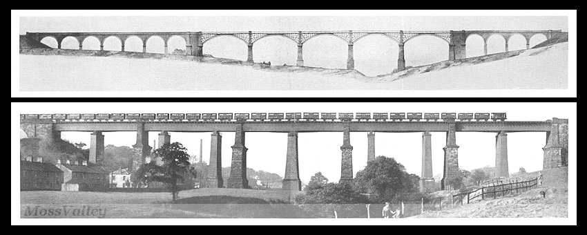
Dinting Vale Viaduct – at the top, the original viaduct, at the bottom, the later replacement.

While the line was being built, the directors were looking at ways to extend it. They had hoped to connect to the Liverpool and Manchester Railway, but their approach to the board of that line was rejected. Eventually they secured a relationship with the London and Birmingham Railway which enabled the Manchester, South Junction and Altrincham Railway to be put before Parliament in 1845. That line was not completed for some years.

The Ashton to Stalybridge branch which had been part if the original scheme was completed in 1845. And in the same year a branch was built to Glossop itself, which needed no Act, since it was financed by the Duke of Norfolk and ran over his land, the original Glossop station was renamed Dinting.

In 1844 representatives of the proposed Sheffield and Lincolnshire Junction Railway made plans for a line from Sheffield to Gainsborough. Plans were also made for the Barnsley Junction Railway to connect Oxspring with Royston on the North Midland Railway.

The directors of the Sheffield, Ashton-under-Lyne and Manchester Railway realised that expansion was best achieved by amalgamating with other lines, after the pattern being set by the Midland under George Hudson.

In 1845, they gained shareholders approval for the Manchester, South Junction and Altrincham Railway,[4] the Sheffield and Lincolnshire Junction Railway,[5] and also the proposed Barnsley Junction Railway.[6] They would also lease the Huddersfield and Manchester Railway and Canal Company.[7]

The board also contemplated:

• a line from Dukinfield to New Mills connecting with the Manchester and Birmingham Railway (https://en.m.wikipedia.org/wiki/Manchester_and_Birmingham_Railway)
• an extension of the Barnsley Junction to Pontefract joining the Wakefield, Pontefract and Goole Railway.
• The Huddersfield and Sheffield Junction Railway.

In September 1845 agreement was reached in a meeting in Normanton, agreement was reached to amalgamate with the Sheffield and Lincolnshire Junction Railway and the Great Grimsby and Sheffield Railway. Further amalgamations included the Grimsby Docks Company Railway and an attempt to take over the East Lincolnshire Railway which was planned between Grimsby and Lincoln, although ultimately that was taken over by the Great Northern.

The merger received royal assent in July 1846 and the combined company was formed at the beginning of 1847. The line became the Manchester, Sheffield and Lincolnshire Railway.[8]


References

1. https://www.gracesguide.co.uk/Sheffield,_Ashton-under-Lyne_and_Manchester_Railway, accessed 9th March 2018.

2. https://www.gracesguide.co.uk/Charles_Vignoles, accessed 10th March 2018.

3. https://www.gracesguide.co.uk/Joseph_Locke, accessed 10th March 2018.

4. https://en.m.wikipedia.org/wiki/Manchester,_South_Junction_and_Altrincham_Railway

5. https://en.m.wikipedia.org/wiki/Sheffield_and_Lincolnshire_Junction_Railway, accessed 10th March 2018.

6. http://discovery.nationalarchives.gov.uk/details/r/C1793638, accessed 10th March 2018.

7. https://www.railscot.co.uk/Huddersfield_and_Manchester_Railway_and_Canal_Company/index.php, accessed 10th March 2018.

8. https://en.m.wikipedia.org/wiki/Manchester,_Sheffield_and_Lincolnshire_Railway, accessed 10th March 2018.

The Sheffield, Ashton-under-Lyne and Manchester Railway – 2

The following are links to information about the line which became part of the Manchester, Sheffield and Lincolnshire Railway in 1847:

http://en.wikipedia.org/wiki/Sheffield,_Ashton-under-Lyne_and_Manchester_Railway

http://www.railbrit.co.uk/Sheffield_Ashton-under-Lyne_and_Manchester_Railway/index.php


The Sheffield, Ashton-under-Lyne and Manchester Railway – 1

I am reading a book by Bill Laws: “Fifty Railways that Changed the Course of
History” published by David & Charles, Newton Abbot, UK, 2013 ISBN-13:978-1-4463-0290-3.

The Sheffield, Ashton-under-Lyne and Manchester Railway features as the 17th of these and particularly for the construction of the Woodhead Tunnel. This was a project that exposed one particular company’s shocking attitude to the safety of its workers and it provided some significant impetus to campaigns for better working conditions for navvies.

“When the early transport ships bearing British miscreants to New South Wales landed in Australia, hundreds had perished during the voyage. The prisoners, including a few of those disreputable railway labourers, notorious for their hard drinking and fighting, were so crammed into the ships’ holds that they died. The British government ordered that, in future, the charterers be held responsible for the convicts’ well-being. It produced immediate results. The transporters, paid a bonus for every prisoner safely landed, now took care of their cargo,” (p72).

However, this principle of responsibility for one’s workers was usually ignore by Victorian entrepreneurs and business leaders: “What use had a mill owner for some eight-year-old girl who, through her own carelessness, lost her hand in a machine? Why should a railway company be responsible for a navvy’s family, when the man died, dead drunk, in a tunnel collapse? And why should the shareholder, risking his capital on such a brave enterprise as the Sheffield, Ashton-under-Lyne and Manchester Railway Company’s plan to tunnel under the Pennines, have to mollycoddle workers who were being paid to do their job?” (p72/73).

Wellington Purdon, who was assistant engineer on the tunnel, was asked by a government enquiry if it was not wiser to use safety fuses while blasting rock He replied, “Perhaps it is: but it is attended with such a loss of time, and the difference is so very small, I would not recommend the loss of time for the sake of all the extra lives it would save, ” (p73).

Purdon’s comments revealed how little the railway companies valued their workers. The enquiry and Purdon’s comments should have changed the course of industrial history. Instead, Parliament shelved the enquiry’s report.

Edwin Chadwick

In 1845 the first train through the completed Woodhead Tunnel was met by a celebration. However, the social reformer Edwin Chadwick did not celebrate for he had calculated that the rate of attrition on the contract to build the tunnel was the equivalent of losses incurred in war. “With 32 killed and 140 injured, the casualty rate was higher than in the Battles of Waterloo” (p73).

The navvies on the Woodhead Tunnel paid to keep their own doctor on hand, Henry Pomfret. “The chief engineer, Wellington Purdon’s boss was Charles B. Vignoles who was also a share­holder in the railway company. When the contract ran over time and over budget, the job bankrupted him. The pioneering engineer Joseph Locke took over as more than a thousand labourers hewed away at the muck and mud from seven different shafts, one at each end and five vertical shafts from above, with pick, shovel and explosives. It was obvious to Locke that the only way to complete the project was to drive the men like animals and, if questioned, lie” (p73/74).

The job took six years to complete. When it came to an end Dr. Pomfret talked to his friend Dr. Roberton, who, inturn talked to Edwin Chadwick. “In January 1846 Chadwick delivered a paper to the Manchester Statistical Society: The Demoralization and Injuries Occasioned by Want of Proper Regulations of Labourers Engaged in the Construction and Works of Railways. Despite the exhausting title, the contents were as volatile as navvies’ explosives. They revealed how injured men were forced to fend for themselves, how most workers lived in homemade hovels (occasioning an outbreak of cholera) through the worst of the Pennine winters. Chadwick exposed the practice of not paying wages for several weeks and then paying them in public bars. The pubs encouraged the navvies to drink their wages, while delayed payments forced them onto the truck system, a version of the company store principle that kept the men and their families in hock to the railway company. (The truck was already outlawed in Britain, but the statute, laid down before the railway rush, had not specified railway workers.) Chadwick showed how the reputation of the average navvy as a feckless, reckless drunk was a direct result of the industry plying him with booze instead of provid­ing him with proper food and housing” (p75).

“The rail company and the engineers denied the charges against them. Nevertheless, the government inquiry in July 1846 recommended extending the Truck Act to the railways, making the companies responsible for the health, welfare and accommodation of their navvies and, most important of all, putting the liability for deaths or injuries on the company. The Members of Parliament also insisted that men should be paid weekly, and in cash, not in tokens for the truck. The inquiry report was never even debated” (p75).

However, “although no railway man was censured over the Wood-head Tunnel scandal, Chadwick’s efforts were not in vain. His correla­tion between losses on the battlefield and those on the railways caught the public imagination and in future, when navvies were killed, the press was quick to take up the story” (p75).

Woodhead Tunnel is infamous for the loss of life during its construction, but it is nothing compared to the massive loss of life associated with many colonial railways in Asia, Africa and South America.