Just after I posted my first article about the Micklehurst Loop, I was sent a series of photographs by an online acquaintance, Tony Jervis. In February 1981, he visited the same length of the Micklehurst Loop as covered in that article. Tony’s pictures show the line before removal of the two viaducts but after the lifting of the length of line retained to serve the Staley and Millbrook Sidings opposite Hartshead Power Station.
Tony also pointed out a further YouTube video from Martin Zero which is embedded towards the end of this addendum. …..
My first article on the Micklehurst Loop can be found using this link:
At the time of Tony Jervis’ visit on 14th February 1981, only one section of the Spring-Grove Viaduct had been removed – a simply supported span which took the line over the Spring-Grove Mill. Toney was very happy for me to share these pictures as an addendum to my original article and he very kindly provided some notes to go with a number of the photographs. I have provided some annotated OS Maps to go with the pictures.
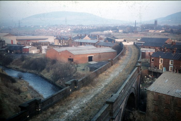
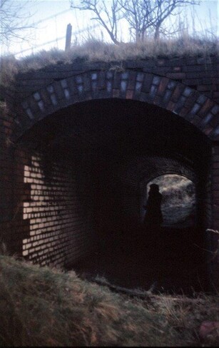
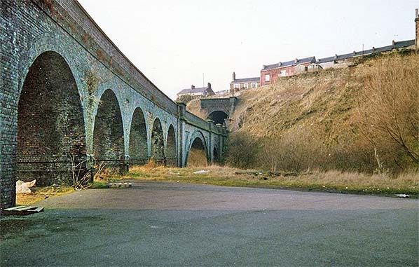
I have retained the reference numbers of the photographs used by Tony Jervis. I find the images fascinating. The first three photographs speak for themselves and are centred on Knowl Street Viaduct at the bottom end of the loop immediately adjacent to Stalybridge New Tunnel.
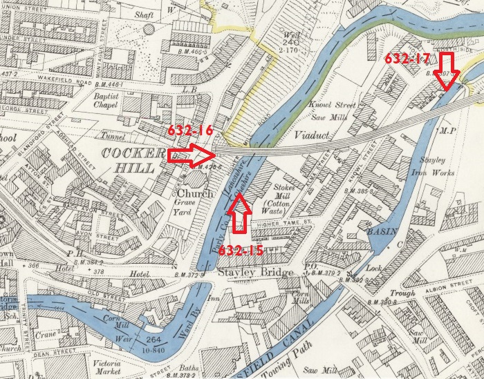
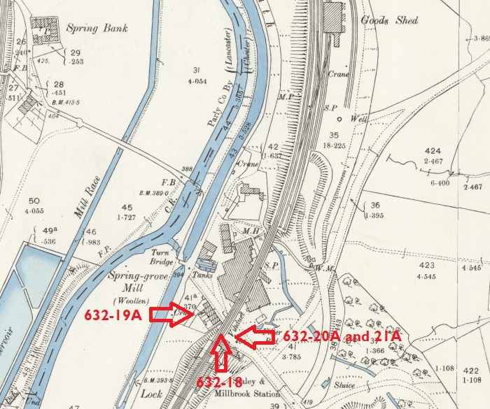
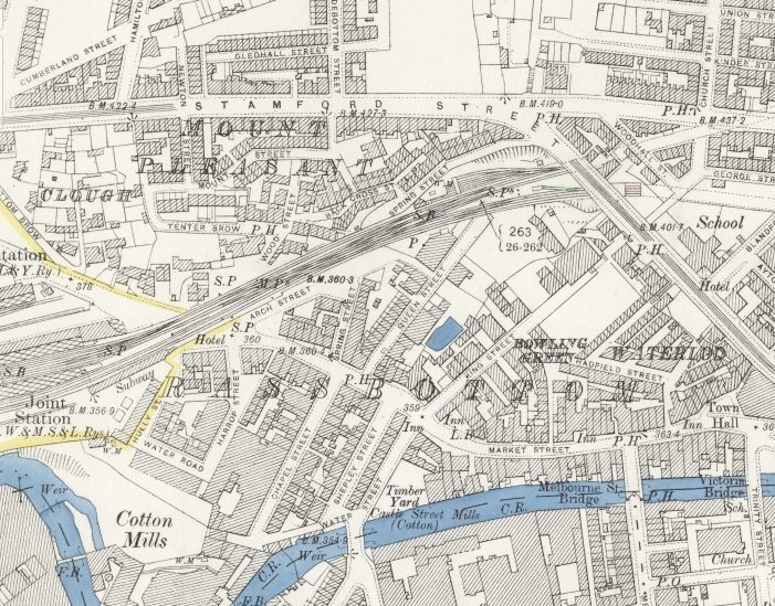
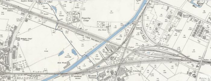
The 25″ OS Map showing the area to the East of Cocker Hill where the Micklehurst Loop broke out of Stalybridge New Tunnel and immediately spanned the River Tame. The locations of three of Tony’s photographs marked. [1]
Photograph 15, 1981, (c) Tony Jervis. [2]
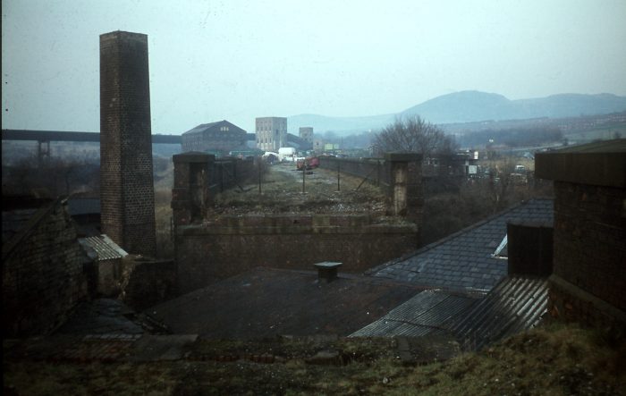
Photograph 632-16, shows the length of the viaduct and is taken from above the Eastern Portal of Stalybridge New Tunnel, 1981, (c) Tony Jervis. [2]
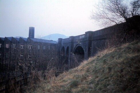
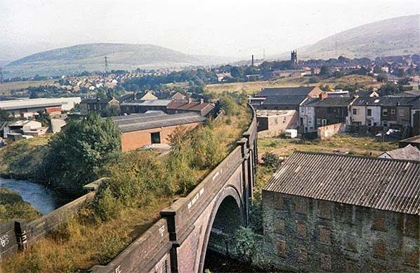
Photograph 632-17,shows the skew span over the Huddersfield Narrow Canal looking towards the Centre of Stalybridge, 1981, (c) Tony Jervis. [2]
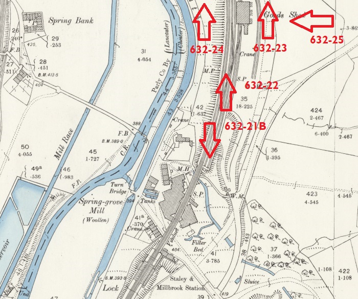
The next few pictures were taken in and around the Staley and Millbrook Station. The software I use allows me to add arrows which are vertical or horizontal but not at an angle, so the locations of the pictures shown on the OS Map immediately below are approximate.
25″ OS Map of Staley & Millbrook Station site at the turn of the 20th century. [1]
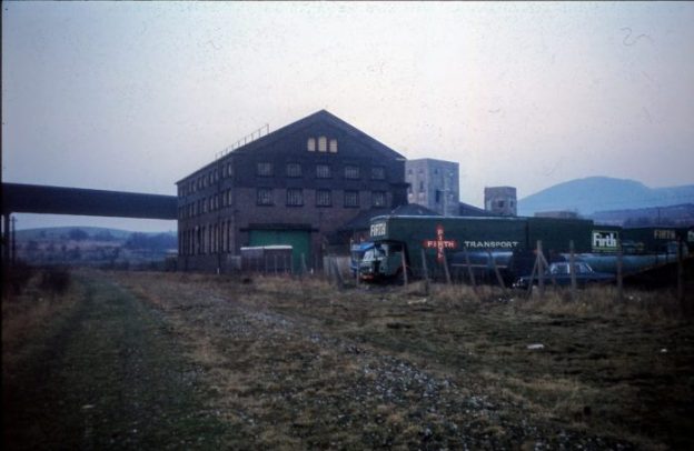
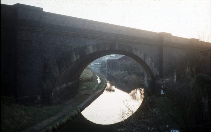
Photograph 632-18 shows Spring-Grove Mill was spanned by a simply-supported girder bridge which had already been removed when Tony Jervis visited in 1981, (c) Tony Jervis. [2]
Tony comments about the above image: this picture shows “the gap in the viaduct over the roof of Spring Grove Mill. I assume the gap was spanned by a horzontal girder bridge, which would have been easier to lift away for scrap than demolish a viaduct arch. In the background, the power station’s coal conveyor and bunkers are still intact, though the station had been closed about 18 months earlier. The goods shed … was still in the hands of Firth Hauliers.” [2]
The Goods shed and part of the conveyor are still in place. The viaduct, the mill chimney,the section of the mill visible to the extreme left of the image, the coal handling facilites are long-gone in the 21st century.
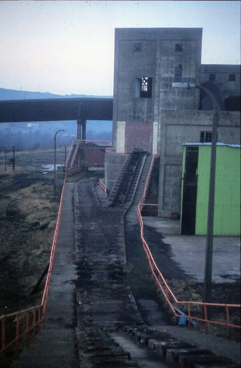
Photograph 632-19A, 1981, the portion of the mill on this (West) side of the viaduct and the mill chimney, still present in 1981, were demolished along with the viaduct in the later part of the 20th century (c) Tony Jervis. [2]
Tony Jervis, writing in 1981, comments: “the station platforms were up to the right at the top of the grassy bank but would not have been accessible for passengers from this side. Beyond the third arch was a span across the top of Spring-Grove Mill, which was presumably modified to allow the railway to be built. I assume the span was some sort of flat girder bridge which has since been craned away.” [2]
Photograph 632-20A, 1981, (c) Tony Jervis. [2]
He continues: “Passengers for the northbound platform would have climbed a covered passage from the booking office and come through this subway (picture 632-20A) whence another short covered ramp or steps would have led up to the platform waiting room. Note the glazed white tiles designed to slightly lighten the subway’s gloom. Since I appear not to have photographed them, I assume that the station platforms had long been swept away.
Photograph 632-21A, 1981, (c) Tony Jervis. [2]
Tony Jervis says: “Picture 632-21A (below) is taken from the middle of Grove Road east of the viaduct. The red brick wall would have been the end of the booking office; the station master’s house would have been out of shot to the left. In the distance is the entrance to the subway. There are marks of the platform retaining wall, which is partly of red brick at the bottom and blue engineering brick further up, that suggest a flight of stairs with an intermediate landing led up the southbound platform and that a lower ramp alongside followed the grass bank up to the subway. One might wonder, thinking of travel a century ago, whether there might have been a need for sack trucks or even a four-wheeled luggage trolley to reach the platforms. The white notice forbidding tipping and trespassing is not in the middle of the road but at the edge of the triangular station forecourt; it won’t show up on the posted picture but above the words is the BR “kinky arrow” symbol. Looking at the 25-inch OS plan, it is interesting to note that the formal entrance to nearby Staley Hall was from Millbrook village to the south but from the back of the building a footpath dropped down to Grove Road alongside the the stationmaster’s house, a tradesmen and servants’ entrance maybe?”
Tony has also provided photographs which were taken late in the evening on 14th 1981 of the Goods Yard across the river and canal from Hartshead Power Station. Their locations are again marked on the 25″ OS Map immediately below ……
25″ OS Map of the Staley & Millbrook Coal Sidings site. The extract does not show the full extent of the sidings which were in place in the mid-20th century..[1]
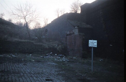
Photograph No. 632-21B 9-644 14 Feb 1981 SD 976000 S Former coal drops at Staley & Millbrook Goods Depot alongside Spring Grove Viaduct. The ruined structure on the horizon is Staley Hall. These drops were just to the North of Spring-Grove Viaduct, (c) Tony Jervis, 1981 – [Tony comments: The “B” suffix is because I managed to give two slides the same number when I numbered them back in 1981.] [2]
Tony Jervis comments: “These coal drops are near the end of the two sidings on the 25-inch OS map closest to the running lines. They are not marked on the map but the road approach for coal merchants’ lorries is clearly shown. I did wonder if the apparent tramway in Grove Road in one of [the photographs in the previous article] was a way of transferring coal from here round to the mill’s boiler house (below the chimney, one presumes) but I have seen no indication of it on any map. The viaduct over Spring Grove Mill starts by the rusty car. The building on the hill is Staley Hall and the “tradesmen’s” footpath I mentioned in a previous description can be seen descending the bank.” [2]
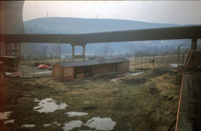
Photograph No. 632-22 9-646 14 Feb 1981 SD 976001 N Staley & Millbrook Goods Warehouse and the former Hartshead Power Station coal conveyor, (c) Tony Jervis, 1981. [2]
Tony comments: This picture shows “the goods shed when in use by Firth Transport. The cleaner ballast in the foreground was the southbound running line and the smoother patch to left of that is presumably where the walkway is today. In the background is the part of the coal conveyor that remains in situ today.” [2]
Photograph No. 632-23 9-645 14 Feb 1981 SD 977002 NW Hartshead Power Station Sidings and start of coal conveyor, Staley & Millbrook Goods Depot, (c) Tony Jervis, 1981. [2]
Tony comments: “One of the two towers on the edge of the power station coal sidings. I presume the “stepped” areas fenced in orange surrounded conveyor belts lifting the coal from siding level up to the high-level conveyor.” [2]
Photograph No. 632-24 9-647 14 Feb 1981 SD 977002 WNW Site of Hartshead Power Station Sidings and coal conveyor, Staley & Millbrook Goods Depot, (c) Tony Jervis, 1981. [2]
Tony comments: “Swinging left about 45 degrees from the previous photo, I’m not sure what purpose this building served. There is a capstan in front of it, suggesting that locomotives were not allowed to traverse the length of surviving track and wagons thereon were moved by cable. Could it have been an oil depot of some sort? The tall pipes at the far end could have been used to empty rail tank cars. Some power stations could burn oil as well as coal; was Hartshead one of them?” [2]
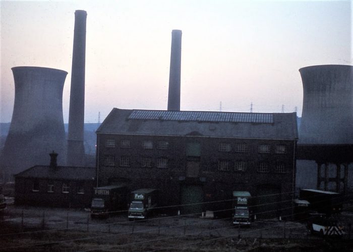
Photograph No. 632-25A 9-648 14 Feb 1981 SD 978002 WSW Staley & Millbrook Goods Warehouse; Hartshead Power Station beyond, (c) Tony Jervis, 1981 [2]
Tony comments: that it was really too dark by the time this picture was taken, none-the-less by screwing the contrast control to its maximum a grainy image of the shed and power station appears reasonably clear but very grainy. [2]
Flicking back and forth between this short article and the latter part of my first article about the Micklehurst Loop (https://rogerfarnworth.com/2021/01/31/the-micklehurst-loop-part-1), will allow a comparison with images of the Staley and Millbrook Station and Goods Depot Sites early in their life and in the 21st century.
To complete this short addendum to my first post here is another video from Martin Zero.
Tony Jervis comments: [4] “After watching the half-hour video, I read some of the comments by other viewers, some of whom had worked on the site. The tunnel turned out to be the power station’s engine shed and the steps led down to a conical underground coal hopper from which conveyor belts took the coal onwards or, perhaps, removed fly-ash.”
“Martin also found on the surface a length of surviving rail track with a lump of iron between the rails that might have been a “mule” or “beetle” for moving wagons slowly past an unloading point. It was mentioned by some people that there had also been an “oil conveyor” — surely a pipeline? — leading from the sidings owards the power station. That makes me wonder if my postulation that the low building in my “S & M Goods 4” posting (slide 632-24) may have been a tank wagon unloading station was in fact correct.”
“Martin did also show a circular object buried in the ground nearby which could perhaps have been the base of the capstan that appears in my photo. But the area is nowadays so afforested that it was impossible to work out accurately how the various items and buildings he found related to one another.”
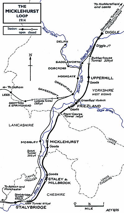
I am indebted to Alan Young for a number of the images in this and the following articles about the Micklehurst Loop. This is his drawing of the Loop which appears at the head of his article about the Loop on the ‘Disused Stations‘ website. It is used with his kind permission, (c) Alan Young. [7]
During January 2021, my wife and I walked the majority of the length of the Micklehurst Loop from Stalybridge to Diggle. This was the goods relieving line for the main Stalybridge to Huddersfield railway line. It had been hoped to alleviate congestion by making the mainline into a 4-track railway but the geography mitigated against this and a route on the other side of the Tame Valley was chosen instead.
The maps used in this sequence of articles are predominantly 25″ OS Maps from 1896 through to 1922 and have been sourced from the National Library of Scotland. [1] There are a number of websites which focus on the Loop which are excellent. The sites concerned are noted immediately below and the relevant link can be found in the references section of this page or by clicking on the highlighted text here:
The most detailed treatment of the line and its stations can be found on the Disused Stations – Site Records website. The particular pages on that site which cover the Loop were provided by Alan Young. One page covers the route and pages covering each of the stations can be accessed from that page. [7]
Particularly good for old photographs of the Loop is the Table 38 webpage about the railway. [12]
Part 1 – Stalybridge to Staley & Millbrook Station and Goods Yard
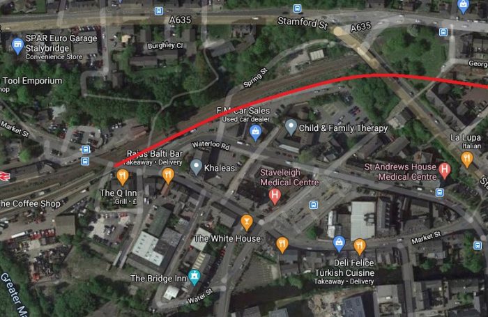
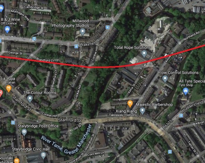
This first map extract shows the Western end of the Micklehurst Loop. It left the mainline at Stalybridge Station which can be seen on the left side of the extract. Both the mainline and the loop entered tunnels under Stamford Street, Stalybridge. [1]This modern satellite image covers approximately the same area of Stalybridge as the map extract above. The route of the former Micklehurst Loop is highlighted by the red line.Looking west towards Stalybridge Station circa 1960 from Stamford Street BR standard Class 5 No.73162 takes the Micklehurst Loop as it pulls away from Stalybridge Station with a Huddersfield-bound freight and approaches Stalybridge New Tunnel. Photo by Peter Sunderland courtesy of Alan Young. [7]
The Western portal of Stalybridge New Tunnel sits just to the East of the Bridge that carries Stamford Street over the route of the Loop. It is difficult to photograph and access is not easy. While search for images of the line I came across a video on YouTube:
This video shows the Western end of the tunnel and then covers a walk through the full length of the tunnel and a glance out of the Eastern Portal. [8]
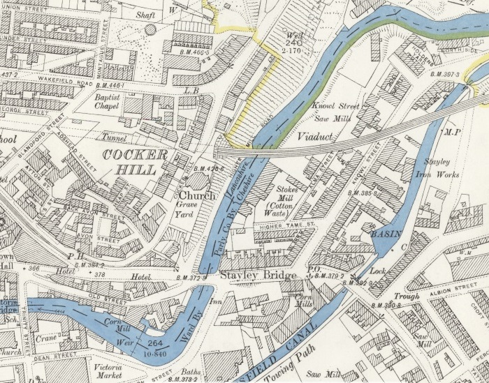
This next map extract shows the Micklehurt Loop emerging from the tunnel under Cocker Hill. The main line is in tunnel further North. Just South of the tunnel mouth Old St. George’s Church can be picked out, an octagonal church building which has now been replaced by St. George’s Church which is off the map extract to the North. Immediately to the East of the tunnel entrance, the Loop crossed the course of the River Tame and the Huddersfield Narrow Canal on a Viaduct.Much has changed in the satellite image above which covers approximately the same area. The canal basin can just be picked out, as can Knowl Street. The course of the River Tame is unchanged. Old St. George’s is long-gone. There is no evidence left of the Viaduct which carried the line.
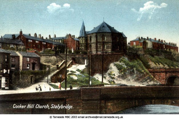
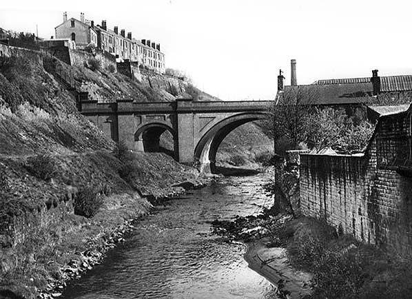
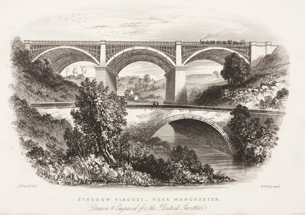
Old St. George’s Church was located almost directly over the tunnel. It was an unusual church building and over its life was rebuilt twice on essentially the same plan. “The first was built in 1776. It was the first recorded church in Stalybridge and it did fall down shortly after it was built. The next church was demolished around a hundred years later because of structural problems and the last church was demolished in the 1960’s as it was no longer used.” [3]The last incarnation of Old St. George’s Church on Cocker Hill. This coloured monochrome image is held in the archives of Tameside MBC. The Micklehurst Loop can be seen exiting the tunnel below the church to the right and immediately crossing the River Tame on Knowl Street Viaduct. [4]This monochrome image is provided with permission, courtesy of Alan Young, once again. [7] He comments: “looking north up the River Tame the western end of Knowl Street Viaduct in Stalybridge is seen in this undated view. Having crossed this 16-arch viaduct the Micklehurst Loop promptly plunged into Stalybridge New Tunnel through Cocker Hill (left). This section of line ceased to handle traffic in 1972, when coal movements to Hartshead Power Station (near Staley & Millbrook) ceased, and the line was taken out of use in July 1976, but it was not until 1991 that the viaduct was demolished.” [7]
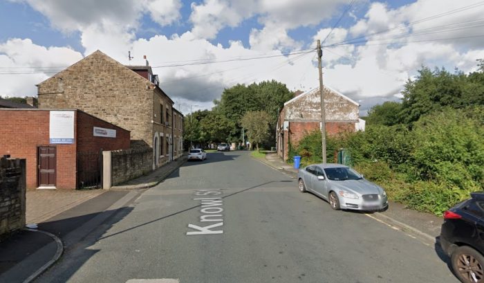
Knowl Street Viaduct carried the Loop over the River Tame, Knowl Street and the Huddersfield Narrow Canal and a series of arches in between. There were 16 arches in all.This photograph taken from the East alongside Knowl Street Viaduct is included with permission, courtesy of Alan Young. [7] Alan comments: “The Micklehurst Loop diverged from the original Huddersfield-Manchester line a short distance east of Stalybridge station, entered Stalybridge New Tunnel (about 300yd in length) then promptly crossed the broad valley of the River Tame on Bridge No.3 (also known as Knowl Street Viaduct). This impressive curving viaduct, in the blue engineering brick used by the LNWR on the Loop’s major structures, was 330yd in length with 16 arches. In addition to crossing the River Tame, the viaduct also strode across Huddersfield Narrow Canal and three roads. In this undated westward view, the viaduct and Stalybridge New Tunnel through Cocker Hill are shown. Coal trains that served Hartshead Power Station ceased to run over the viaduct in 1972, but it was not until July 1976 that the line was officially taken out of use. Fifteen years elapsed before the viaduct was demolished in 1991.” [7]A further image used with permission, courtesy of Alan Young. [7] Alan comments: “Looking north-east from a point close to the eastern portal of Stalybridge New Tunnel. The Knowl Street Viaduct, 330yd in length and with 16 arches, is seen crossing the River Tame then curving away towards the next station of Staley & Millbrook. The local passenger service on the Micklehurst Loop, on which this viaduct was located, ceased in 1917, but occasional passenger trains and many freight workings continued into the 1960s; coal traffic continued to pass over the viaduct until 1972 en route to Hartshead Power station near Staley & Millbrook station and the line was officially taken out of use in 1976. Nature is taking over the former trackbed as seen on this undated photograph. The viaduct was demolished in 1991.” [7]A modern view of Knowl Street taken from Google Streetview. Knowl Street Viaduct crossed Knowl Street at this location. The spandrel walls on the North side of the Viadct passed very close to the gable end of the terraced building to the East of Knowl Street, the righthand side in this view.
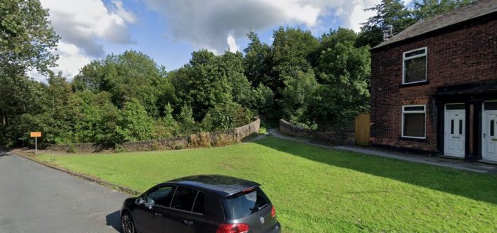
After crossing the Huddersfield Narrow Canal the Loop line regained the embankment shown on the next OS Map extract below. Just to the North of the point where the viaduct crossed the canal is a stone bridge carrying what is now (in the 21st century) the canal-side walk. That bridge is shown at the centre of the Google Streetview image below and at the bottom left of the OS Map extract. It is named Knowl Street Bridge and carries the number 97. [8]
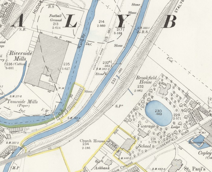
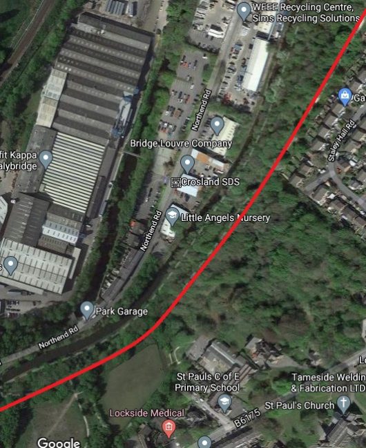
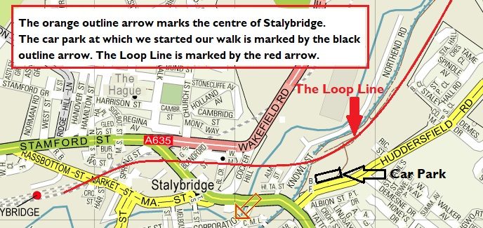
After crossing the Canal the line was carried on embankment, passing to the West of Brookfield House and running North by Northeast parallel to the Canal with Huddersfield Road a distance away to the South. Across the valley of the River Tame to the West were Riverside Mills.The approximate line of the railway, shown in red, runs parallel to the canal. We parked in a small car park just off the south of this satellite image, as illustrated below. The image shows that the site of the Riverside Mills is now occupied by the premises of Smurfit Kappa, Stalybridge. [9]Stalybridge and the Southwest end of the Micklehurst Loop.
Brookfield House was “a large detached house built in the early 19th century for James Wilkinson, and shown on the 1850 Stayley Tithe Map. All that remains is the former mid-19th century lodge house at 93, Huddersfield Road, with the entrance to the former drive with stone gate piers on its south side. The grounds of Brookfield House are clearly shown on the 1898 OS Map, and included an oval lake and glasshouses, …. Brookfield House was demolished and the lake filled in between 1910-1933. The grounds are now overgrown with self-set woodland.” [2]This next OS Map extract illustrates, at the the top right, how tightly the river, railway and canal follow each other at times up the Tame Valley. The railway sits above the canal which in turn sits a little above the river. Also evident is the name used on this series of OS Maps for the Loop Line – the “Stalybridge and Saddleworth Loop Line.”
Alan Young explains: “Although described as both the ‘Stalybridge & Saddleworth Loop‘ and ‘Stalybridge & Diggle Loop‘ on Ordnance Survey maps, the line is more commonly known as the ‘Micklehurst Loop’.” [7]
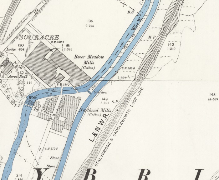
River Meadow Cotton Mills were owned by Henry Bannerman who was a successful farmer in Perthshire, Scotland At the age of 55 in 1808 he “moved with his family to Manchester, determined to get involved in the burgeoning Lancashire cotton industry.” [10]
At one time the company had “four cotton mills in the Manchester area: Brunswick Mill in Ancoats, Old Hall Mill in Dukinfield and the North End Mill and River Meadow Mill, both in Stalybridge.” [10]
In 1929, the Lancashire Cotton Industry was struggling. It had not regained its markets after the First World War. In an attempt to save the industry, the Bank of England set up the ‘Lancashire Cotton Coroporation’. Bannermans’ mills were taken over a few years later. The mills were acquired by Courtaulds in 1964 and all production ceased in 1967.” [10] After closure the four-storey mill which was Grade II Listed “was used by Futura before they moved to Quarry Street and then S. A. Driver warp knitters, dyers , printers and finishers.” [11] As can be seen in the satellite image below, the Mill is now demolished.Souracre and River Meadow Cotton Mill and Souracre in the 21st century .
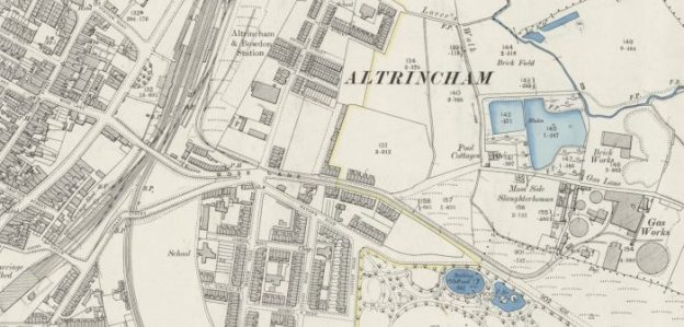
North of Souracre and visible at the bottom left of this next OS Map extract were Hartshead Calico Print Works East of Printworks Road and close by Heyrod Hall. Also visible on this map extract are Stayley Hall and the first Station on the Micklehurst Loop – Stayley and Millbrook Station.
Hartshead Print Works – is visible just below centre-left on the OS Map extract above. The works was listed in the Stalybridge Directory of 1891 as owned by John L. Kennedy &Co. Ltd, Calico Printers. lt was purchased in 1899 by the Calico Printers Association. [18]
Heyrod Hall – is shown on the top left of the OS Map extract above.
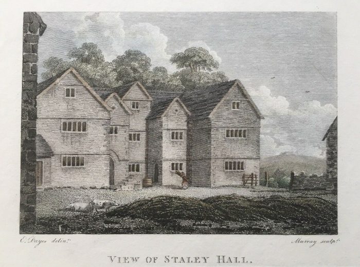
Stayley Hall – is a Grade II* Listed Building which dates back to at least the early 15th century.[14] The first records of the de Stavelegh family as Lords of the Manor of Staley date from the early 13th century. Stayley Hall was their residence. [15]
It came into the possession of the Assheton family through marriage and united the manors of Stayley and Ashton and thence into the family of Sir William Booth of Dunham Massey. In the middle of the 16th century. [15]
Stayley Hall 1795. [21]
In the middle of the 18th Century the Earldom of Warrington became extinct and the Hall, alonng with all the Booth’s estates passed to Harry Grey, 4th Earl of Stamford. Stayley Hall was owned by the Booth family until the death of Roger Grey, 10th Earl of Stamford in 1976. [15]
Wikipedia concludes its history of the Hall as follows: “In 2004 the Metropolitan Borough Council announced that they had granted permission to a developer to build 16 homes next to Stayley Hall. A condition of the planning consent was that the hall be restored.[3] The developer has converted the hall and outbuildings into houses and apartments, most of which are now occupied.” [15]
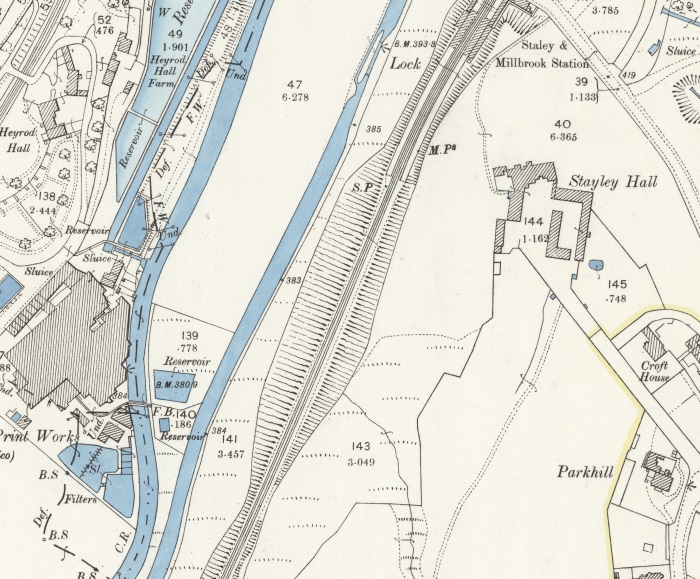
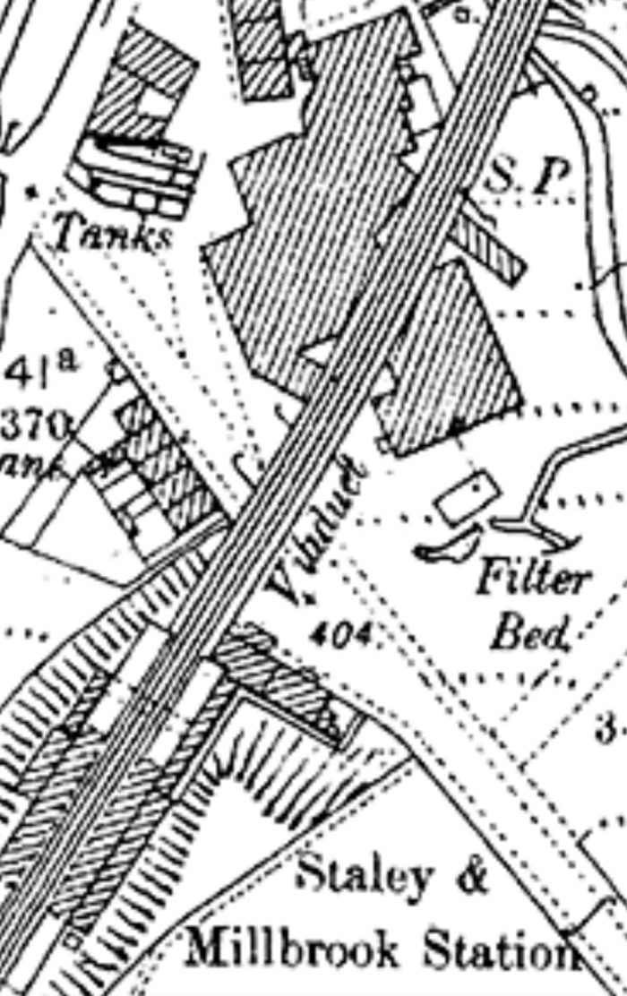
Early 25″ OS Map covering the length of the passenger facilities and most of the goods facilities at Staley & Millbrook Station. [1]
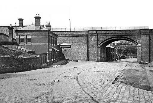
Staley and Millbrook Station – Alan Young’s on his webpage about the Station comments as follows: “Staley & Millbrook station stood on a steep slope immediately south of Spring Grove Viaduct. The two facing platforms were equipped with waiting rooms, most likely of timber construction, with glazed awnings, as is thought to have been the building style at all four of the Loop’s stations. The platforms, too, were most likely of timber construction as that material was used for the platforms at Micklehurst, where they were also on an embankment, and timber would be a much lighter load than masonry for an embankment to support. The stationmaster’s house and adjoining single-storey office range to its west faced Grove Road across a small, triangular forecourt. The station house was constructed of dark red brick with string courses of blue engineering brick and pale stone lintels.” [18]Staley & Millbrook Station building and the Sprong-grove Viaduct take from the East on Grove Road in the early 20th century. The picture shows a clean and relatively well maintained site, very different to what remains in the 21st century, please see the pictures below. [18]Staley and Millbrook Railway Station and Spring-grove Mill. [16]
Staley and Millbrook Station buildings have long-gone as has the Viaduct, the first arch of which spanned Grove Road and looked to be a graceful structure. Also of interest in the monochrome picture of the Station and Viaduct above is what appears at first sight to be evidence of a tramway or industrial railway in the cobbles of Grove Road. I have not as yet been able to find out anything about what this feature actually is. The feature is not marked on the map extract immediately above. Closer examination of the picture above suggests that rather than being part of a short industrial line the cobbles may have been laid to facilitate a particular movement around the Spring-grove Mill.
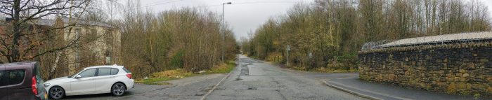
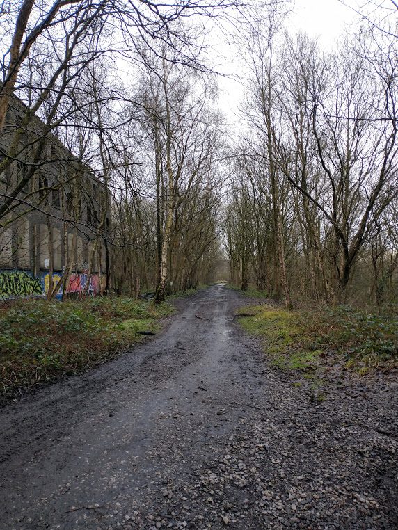
In the 21st century, this length of Grove Road has been tarmacked – a thin layer of tarmac covers the original sets. The next two pictures were taken on 30th January 2021 on a second visit to the site after walking the route of the Loop.
Taken from East of the route of the Micklehurst Loop, this photograph shows the location of the old station building. It sat facing the road on the left-hand side of the panorama. The Southern abutment of the viaduct sat adjacent to the station building, in the area of trees between the 5-bar field gate and the stone wall towards the right of the picture. The masonry wall is in the location of what were terraced houses between the canal and the railway viaduct. (My photograph, 30th January 2021)Another panorama, this time taken from the canal bridge to the West of the Loop. What is left of Spring-grove Mill can be seen on the left side of the image. Grove Road, heading towards Millbrook is central to the image. The masonry wall is the location of the terraced houses mentioned above. The first trees beyond it mark the line of the viaduct. The station building was sited beyond to the West. (My photograph, 30th January 2021)
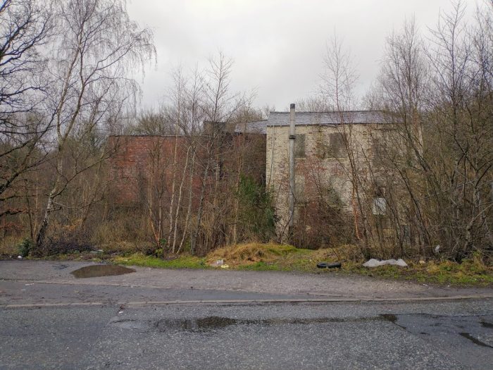
Spring-grove Mill – As we have already noted, Spring-grove Mill is shown straddled by the viaduct on the OS Map extract above. When Staley & Millbrook station opened, “there was already some population and industry in the immediate neighbourhood. Spring Grove Cotton Mill faced the station across Grove Road, and map evidence suggests that the railway’s viaduct sliced through the existing mill building. A terrace of three cottages, also pre-dating the railway, stood immediately north of the platforms, and Stayley Hall was about 100yd south of the station. Millbrook village, with three cotton mills, was about ten minutes’ walk uphill east of the station.” [16] [18]The remaining buildings of Spring-grove Mill. The lighter (cream painted) brickwork is the part of the mill shown on the map extracts as being on the East side of the viaduct. The portion of the Mill to the West of the viaduct has been demolished. The red-brick portion of the remaining building would have been under the arches of the viaduct. The Western spandrels of the viaduct arches would have followed a line running from the intersecting kerb-stones in the right-foreground over the redbrick part of the present building. (My own photograph – 30th January 2021)
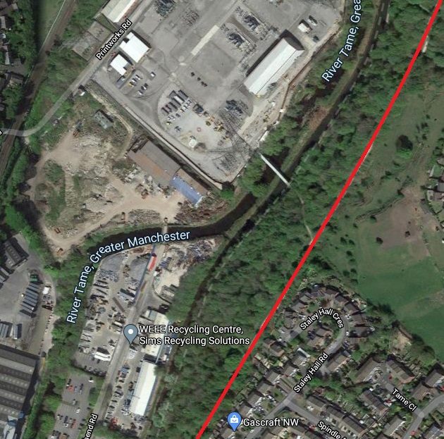
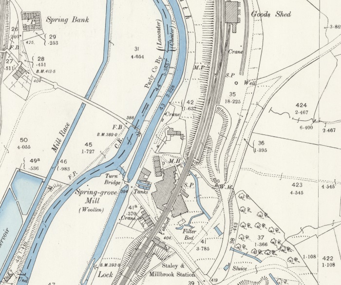
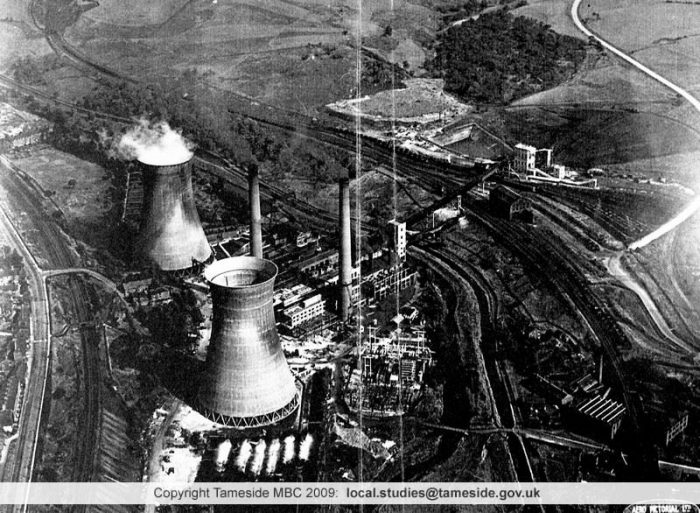
Spring Grove Mill was a cotton mill from 1818 to 1868 and then was a woollen mill for 100 years, it was the last steam-powered mill in the area. [17] The image of Hartshead Power station below, includes Spring-grove Mill in the bottom right-hand corner. By the time the aerial photograph was taken Grove Road appeared to extend across the Canal and the River Tame towards Heyrod.
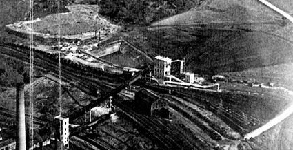
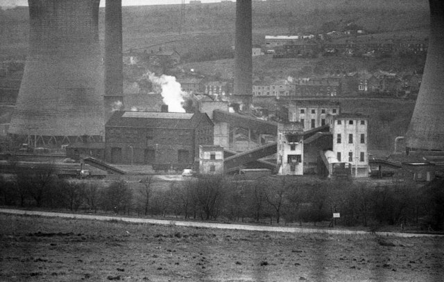
Hartshead Power Station was also located North of Souracre to the West of the River Tame. It was a coal-fired station and was served by trains on the Micklehurst Loop up until the 1970s. The picture immediately below was posted by Tameside Council on their Facebook page in 2015.An aerial picture of Hartshead Power Station taken before the Second World War. It was opened by the Stalybridge, Hyde, Mossley and Dukinfield (SHMD) Joint Board in 1926 and the cooling towers were erected in the 1940s. The station closed in 1970 and was demolished in the 1980s. Although the Good Shed visible to the top right of the image still stands. The Micklehurst Loop curves from the bottom right to the top left of the picture. [13]This enlarged extract from the image above show the coal transfer facilities and railway sidings associated with the power station . [13] The resolution of the image is not wonderful but it does highlight the traffic which was brought to the site throughout the middle 50 years of the 20th Century.
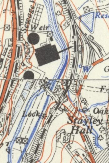
OS 1:25,000 Map form the early- to mid-20th century, sourced from the National Library of Scotland – Hartshead Power Station. One of the two cooling towers is not shown in full as it crosses the map join. [14]
The full extent of the Hartshead Power Station site at Souracre can be seen on the adjacent OS Map extract from the middle of the 20th century, which also shows the location of Stayley Hall and the Stayley and Millbrook Station build just North-northwest of Stayley Hall.
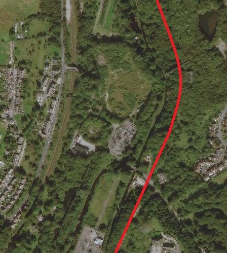
Approximately the same area is shown below on a relatively recent extract from the ESRI World Image website which is the satellite mapping used by the National Library of Scotland. [13]
The Good Shed which is considered further below is visible on both the map extract and the satellite image and the extent of the railway sidings on the East side of the Loop line is evident.
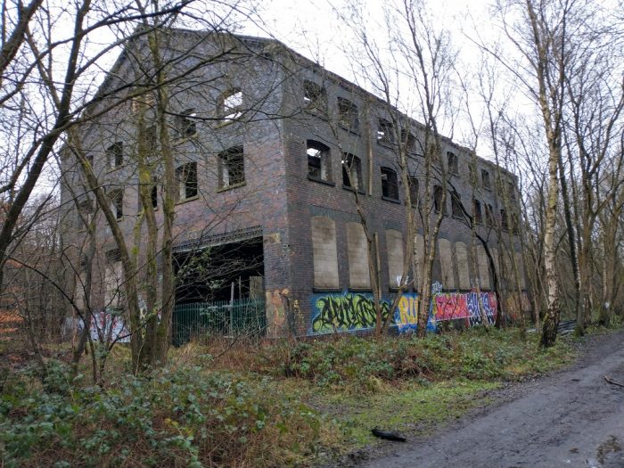
The substantial Goods Shed was built at the same time as the Loop initially with two sidings to its East. These sidings were expanded with the advent of the power station in the early 20th century. The site is now overgrown and is returning to nature. The only exception being the Goods Shed itself. There is an excellent video showing its current condition on ‘Martin Zero’s’ YouTube Channel which is embedded below. My own pictures of the site also follow below.
The Goods shed at Stayley and Millbrook Station presided over a large expanse of sidings which served Hartshead Power Station on the opposite side of the Huddersfield Narrow Canal and the River Tame. [22]Looking South towards the location of the passenger facilities at Staley and Millbrook Station. The Goods shed is on the left (the East side of the Loop line). (My photograph, 18th January 2021).The Goods Shed taken from the same location as the last photograph – a substantial three-storey structure. (My photograph, 18th January 2021).
The next part of this walk following the line of the Micklehurst Loop sets off from this goods shed traveling North.
An item about the Altrincham Gas Works Tramway appeared on the Industrial Railway Society (IRS) email discussion group to which I belong. [2] John Pitman on that discussion group provided a link to Dr. Mark Newall’s website. [3]
This article grabbed my attention because for the first 5 years of my life in the early 1960s I lived in Altrincham – Broadheath, to be exact. I was born in Altrincham Maternity Hospital in 1960. I always keep my eye open for interesting snippets of information about the various places that I have lived.
In 1870-72, John Marius Wilson’s Imperial Gazetteer of England and Walesdescribed Altrincham like this:
ALTRINCHAM: …. “a town, a township, two chapelries, a subdistrict, and a district, in Cheshire. The town is in the parish of Bowdon, at an intersection of railways, adjacent to the Bridgewater canal, 8 miles SSW of Manchester; comprises good streets and some handsome villas; is a seat of petty-sessions and county courts, and a polling-place; publishes a weekly news paper; carries on iron-founding, bone-grinding, timber sawing, much trade from neighbouring market-gardens, and much transit traffic, and has a head post office, three raIlway stations, two chief inns, a town hall of 1849, a literary institution in the Tudor style enlarged in 1864, a plain church of 1799, a church in the decorated English style built in 1867, a Wesleyan chapel in the Byzantine style built in 1864, five other dissenting chapels, a Roman Catholic chapel, five public schools, a medical hospital, charities £57, a weekly market on Tuesday, and three annuals fairs.-The township comprises 657 acres. Real property, £24,087. Pop., 6,628. Houses, 1,240.” [10]
But, there is no mention in Wilson’s work of a Gas Works present at the time!
It seems that in the 19th century, 3 different gas works existed in Altrincham. The earliest was established in 1844, initially intended to serve an immediate area around the works. It only lasted for 3 years before it was purchased and closed as the main Gas Works was opened in 1847.
South Trafford Archaeological Group produced a short piece about the Altrincham Gas Works just a few days before Newall’s article. As does Newall, they point out that the Altrincham Gas Works were built by 1847. Both add that the third Gas Works were railway related, established to supply gas for carriage lighting.
The light railway, or tramway, between the Gas Works and Altrincham Railway Station was not established until provision was made for it under the Altrincham Gas Act of 1893, as a single track of standard gauge. It cost £1,820 to build, was in operation by 1895 and for many years was horse-drawn.
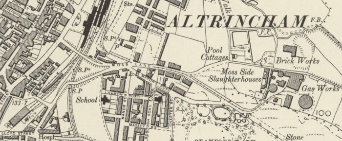
The South Trafford Archaeological Group point out that, “The tramway ran from the sidings at Altrincham Station for roughly a third of a mile (c. 500m) to the gas works on Moss Lane, where a series of sidings ran around the site. The light railway carried coal for the gas works which was used in the production of ‘town gas’.” [4]
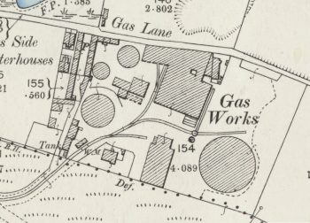
The majority of the length of the short tramway – as shown on the 25″ OS Map from the turn of the 20th century, soon after it was constructed. (The detailed layout in the Gasworks is shown below on enlarged OS Map extract.) This extract shows the line running from the Gas Works, along Moss Lane, to the railway station yard. [15]
The map extract above shows the line of the tramway from the Gas Works to the Railway Station Yard. The adjacent extract shows the track arrangement within the Gas Works at about the turn of the 20th century. [15]
“At the station end of the tramway, … the land alongside
the depository was owned by the gas company …; beyond there the land belonged to the railway but the tracks were the responsibility of the gas company. The gas company’s authority ended just before the two sidings became one (on the east side of the station yard).” [5: p198]
Before the tramway was constructed, “coal was conveyed by horse-drawn wagons along the streets to the gas works. The route between the station yard and the gas works was partly along what was, in effect, little more than a rough bridleway (later known as Moss Lane); although unsuited in some ways to the transportation of coal, at least there were no significant gradients to contend with.” [5: p197]
The demand for gas rose quickly in the second half of the 19th century. “By the 1890s the increasing demand for gas meant that easier access to a larger supply of coal … had to be sought. …. [The tramway] was in operation by 1895 and initially was horse-drawn.” [3]
This extract for the 6″ OS Mapping of 1899 also shows the relatively newly constructed tramway serving the Altrincham Gas Works. [8]
The use of horses pertained until the 1930s, when a Sentinel steam lorry running on road wheels was purchased. It was built “by Sentinel of Shrewsbury in 1924, was employed from 1933 to pull the coal trucks.” [4]
The growth in the use of gas in Altincham is evidenced by the increasing use of coal. By 1919, 20,000 tons was used during the year. By 1933, usage had risen to in excess of 32,000 tons of coal. [5: p201]
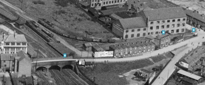
The Gas Works Tramway in Altrincham from above.. This image covers the curved sidings on the East side of Altrincham Railway Station. Coal wagons are much in evidence. This view was taken in 1927. [6]
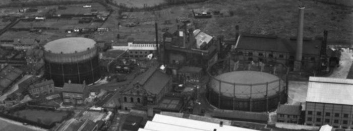
An aerial image of the Gasworks taken from the South in 1951. Careful inspection wil show at least one wagon in the Gas Works site to the right of the Gasometer on the left side of the image. [7]
In 1943, a Peckett 0-4-0ST took over locomotive duties from the Sentinel steam lorry. Newell says that this was “Peckett’s W/No. 2034, a ‘Yorktown’ type 0-4-0ST, and the new tank engine was named ‘Arthur E Potts’, after one of the company directors.” [3] No. 2034 left Peckett’s works on 27th May 1943. [13]
The Peckett was joined by “a second locomotive …. in 1947, a four-wheel vertical boiler engine built by Sentinel (W/No. 9375).” [3] Dixon says that this was a diesel loco, [11] but research suggests that Sentinel (W/No. 9375) was a steam locomotive. Sentinel Locos with this range of Works Nos. were all steam-powered. An example is Works No. 9376 which Sentinel’s records show as a Vertical Boiler Steam Loco built in 1947 for ‘Ind Coope and Allsop’ and used at their Burton Brewery. [12] Millichip explains: “This type of engine, with enclosed cylinders and chain drive to the leading axle, was eminently suited to gas works duties. Coke dust, which proliferated in gas works, always seemed to be attracted to the motion and other moving parts of conventional locomotives, and when mixed with oil the effect was far from satisfactory.” [5: p203]
These two locos (Peckett and Sentinel) shared 4 or 5 trips per day between the Gas Works and the Railway Station Sidings on weekdays. [11]
The tramway ran eastward from the Southern end of the sidings at Altrincham Railway Station to the Gas Works where there were a series of sidings that served the Works. Newell says that the “line entered the gasworks from the south-west, passing a weighing machine and an associated building on the western side of the track. It then threaded its way between two gas holders before branching north and eastwards towards two process buildings. Three turn tables gave extra flexibility for the coal wagons accessing these buildings.” [3]
In summary, Newell says that the essential changes were:
1908: a short 50 metre siding running north from Moss Lane between Oakfield Road and Balmoral Road
1936/1937: doubling of the tracks at the Railway Station.
various changes to sidings in the Gas Works over the years
1951: a siding accessing a processing building to the East end of the Gas Works site.
Millichip talks of the siding at the station being very difficult to shunt because there was only a small passing loop available. This meant that a rope hawser was used to facilitate shunting. The two sidings mentioned by Newell above were not connected in a way that would allow either of the Gas Works engines to run round the wagons delivered to the Station Goods yard. [5: p203] Millichip and Robinson provide two excellent shots of the rope -shunting taking place. [5: p203 & p204] In the second of these pictures the short passing loop is visible.
The Altrincham Gas Works was nationalised in 1949 when it became part of the North Western Gas Board. Millichip tells us that North Western Gas Board was one of twelve gas boards set up at Nationalisation and took over not only the Gas Works but nearby offices and a gas showroom on Cross Street in Altrincham [5: p204]
Gas production at Altrincham ceased on 26th June 1957. [5: p204] Newell tells us that the tramway was closed in December 1957, track was removed in 1958, and the Moss Lane site became the headquarters of the Gas Board, opening in 1965. The two gas-holders at the Gas Works survived this work but did not survive beyond the end of the 20th century. [3] The whole site, including the headquarters building were redeveloped in the first decade of the 21st century as housing and a new ice-rink. [3][5: p204]
M. Newall in Reference [3] below mentions a 14 year period. It seems as though the line was first constructed by around 1895 and was still in use in the late 1950s – see references [5] and [9] below.
The Museum of Transport Greater Manchester has shared an image from 1959, showing the tramway in productive use; https://flic.kr/p/2jy9WSY, accessed on 16th December 2020.
I still have a number of older railway magazines to read through. The pile still seems to be growing!
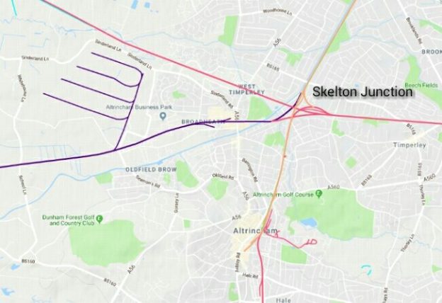
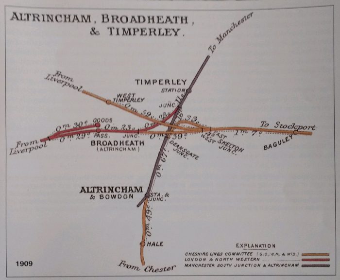
The November 2003 issue of Steam Days has an epic article about Skelton Junction. [1] Skelton Junction is in Broadheath which is just North of Altrincham. I picked up my copy of magazine in August (2019).
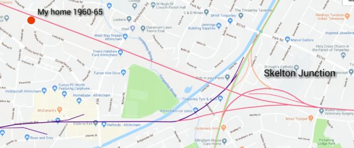
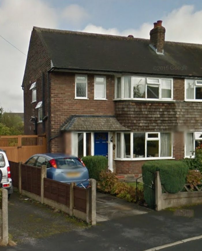
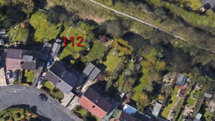
Broadheath was my home for the first five and a half years of my life. I can remember the railway at the bottom of the garden and also vaguely remember my grandparents waving to me from their train as I stood in the back garden of our home – 112, Lindsell Road, Broadheath, Altrincham.
The featured image for this post is taken from RailMapOnline. It shows the immediate area to the North of Altrincham. [2] The same website shows, below, the distance of our home from Skelton Junction. [2] … Not that close, but enough to provoke my interest as I read the article.No. 112 Lindsell Road in the early 21st Century (Google Streetview).No. 112 Lindsell Road in the early 21st Century (Google Earth) the disused West Timperley to Glazebrook line is visible to the top right of the satellite image.
Railways arrived in the vicinity in 1849. An Act of 21 July 1845 had incorporated ‘The Manchester South Junction & Altrincham Railway’ (MSJ&AR). It opened for traffic on 28th May 1849. I was interested to note that the development of the railway sysytem in this area can be linked back to shared decisions in which The Sheffield, Ashon-under-Lyne and Manchester Railway was involved!
This “line sprang from a desire by the Manchester & Birmingham and the Sheffield, Ashton-under-Lyne & Manchester railways to reach Liverpool. Thus was taken on board by the two companies the so-called South Junction Railway — a line about one mile long from Oxford Road in Manchester to a junction with the Liverpool & Manchester Railway at Ordsall Lane in Salford, immediately west of Liverpool Road station. Given the line’s original concept, the branch west to Altrincham was an afterthought. This new railway would parallel the Bridgewater Canal for much of its course, and inevitably become a competitor for its traffic. Eight miles long, the MSJ&AR could be fairly said to have created many of the suburbs through which it travelled.” [1: p687]
All of the suburbs between Altrincham and South Manchester did not exist before the building of the line – Old Trafford, Stretford, Sale, Brooklands, Timperley. They all only became viable as dormitory areas when public transport became adequate to convey the middle classes into Manchester. The building of this line also acted as a catalyst for the construction of further lines. many of these lines came early in railway development across the country:
The line from Warrington to Timperley (1854) which was extended to Stockport (1865)
The extension of the Altirncham line to Knutsford (1862) and on to Chester (1874).
A line through West Timperley and on via Glazebrook to Liverpool (1873).
“Broadheath, whose only transport focus was once the Bridgewater Canal, would see a myriad of industrial development in the late 19th and early 20th centuries. … The Earl of Stamford, the major landowner in the area, was careful to restrict development in the main to the north bank of the Bridgewater Canal.” [1: p689]
“John Skelton sold some of his … land to the Stockport, Timperley and Altrincham Railway Company in the 1860s to build a link line between Stockport and Warrington, and his name is preserved in Skelton Junction.” [9]
An OS Map extract showing Skelton Junction and Broadheath in 1898. There is no sign of Lindsell Road at this time. [4]
West Timperley Station was about 3/4 mile to the West of Skelton Junction, just off to the Northwest of the map above. It was on the Cheshire Lines Railways’ (CLC) Glazebrook to Stockport Tiviot Dale Line. The length of the line through the station opened to goods from Cressington Junction to Skelton Junction in 1873 with passenger workings beginning later in the same year. The line gave the CLC their own route to Liverpool. Previously they had had to operate over LNWR metals between Skelton Junction and Garston.
Paul Wright, writing on the Disused Stations Website says:
“Partington (and by inference, West Timperley) was served by local trains running between Stockport Tiviot Dale and Liverpool Central with some short workings going only as far as Warrington Central. Express services to London St. Pancreas and other destinations along with a steady stream of goods workings passed through the station.
Situated on an embankment [West Timperley] station had two platforms which linked to the road by slopes. Booking and waiting facilities where located on the platforms with the main facilities on the Stockport platform.
The station remained part of the Cheshire Lines Railway until 1948 when it became part of British Railways London Midland Region. The station closed to passenger services on 30.11.1964. Regular passenger trains continued to pass through the station site until 1966 when Liverpool Central closed to long distance services. The line remained a busy route for goods services until 1984 when the bridge over the Manchester Ship Canal at Cadishead closed. The line was cut back to Partington and singled. Goods services operated along this section of line until the 10th October 1993. Today [2006] the platforms at West Timperley are still extant and the single line remains in situ.” [5]
West Timperley would possibly have been the station my grandparents used when they came to visit!
There is discussion of Skelton Junction and surrounding lines on a number of threads on http://www.railforums.co.uk. [6][7][8]
References
Eddie Johnson; Skelton Junction, Its Traffic and Environs; in Steam Days, Red Gauntlet, Bournemouth, November 2003, p687-702. This article is excellent. Copyright restrictions prevent me copying it as an appendix to this post.
How a long defunct, relatively small local railway company aimed high and ultimately was responsible for the poor financial state of the Great Central Railway!
I was prompted to look again at the Sheffield Ashton-under-Lyne and Manchester Railway by reading a copy of BackTrack Magazine from May 1996 (Volume 10 No. 5) [2] which included an article about the Great Central Railway which is now, sadly, long-gone. That article was itself a response to an earlier article in BackTrack Volume 9 No. 3 (March 1995) by Messrs. Emblin, Longbone and Jackson. [1]
It brought to mind the connections between Ashton-under-Lyne and the Manchester, Sheffield and Lincolnshire Railway (MS&L) evidenced by the name of its predecessor, the Sheffield, Ashton-under-Lyne and Manchester Railway (SA&M). I am wary of providing links to these posts, but they do pull together quite a bit of information about that railway …… these are the links:
With the benefit of hindsight, the second of the above posts was not really necessary. An appendix to the third post would probably have covered the two links mentioned in the second post.
I lived in Ashton-under-Lyne at the time. The article which grabbed my attention in the old BackTrack Magazine did so because it seems to root the significant problems of the Great Central Railway (GCR) in my, then, local railway company’s own history. Hence the sub-title of this post!
The significant challenges faced by the SA&M Railway in being ahead of the game in providing rails across the northern backbone of the country led to a financial structure which seems to have dictated the future of its successors, both the MS&L and, ultimately, the GCR. Heavily reliant, leveraged, on debentures and preferential stock is was difficult for the successive companies to attract ordinary investors.
The whole history of the GCR seems to have been dictated by the way in which the heavy capital expenditure necessary to cross the Pennines/Peaks was financed.
The SA&M Railway was one of the first railways to tackle truly formidable and desolate terrain. Nowhere was the challenge more evident than at the West end of the Woodhead tunnels, seen here at the turn of the 20th century. The SA&M and its successors were encumbered with the twin problems of high construction costs and low receipts from intermediate stations over a long section of line. [2]
It should be noted that Emblin reserved a right of reply and that he chose to do so in a later edition of the BackTrack Magazine. [5]
His principal argument in that article appears to be that things were really not that bad and that the GCR managed its way out of trouble in a very effective fashion. I am not sure that this negates the reasoning of the articles referred to above, and I am sure that it does not address the particular point that the GCR faced ongoing financial problems which had their birth in the companies it succeeded.
Emblin argues strongly that Sir Alexander Henderson managed his way out of trouble by expansion. [5: p711] That seems to have been that practice of his predecessors as well. The result being that the company was highly leveraged and still not the best investment for ordinary shareholders.
It also does not alter my opinion that my, then, local railway company had a great part to play in the issues which has to be managed by the GCR throughout its life.
References
1. Emblin, Longbone & Jackson; Money Sunk & Lost; BackTrack Magazine Vol. 9 No. 3, p129-136, notes on this article are reproduced below at Appendix 2. [3]
2. Blossom & Hendry; Great Central – The Real Problem; BackTrack Magazine Vol. 10 No. 5, p266-271. Notes on this article are provided at [4].
The extension of the MSLR from Annesley to London created what the authors describe as a myth, namely that the Great Central Railway was financially crippled by the cost of building it. Many authors have subscribed to that myth: Langley Aldrich’s “The late GCR never paid any dividend on its Ordinary shares”; Hamilton Ellis’s ‘The London Extension was viewed with pessimism at the time of its inception; if MS&L stood for Money Sunk and Lost, GC clearly meant Gone Completely”. Jack Simmons “Great Central never paid an ordinary dividend” and “was financially ramshackle”. Harold Pollins “There were clearly some absurd schemes [including] the building of the last main line, the Great Central, in the 1890s” Michael Bonavia, referring to the grouping criteria used in defining the proto-LNER, adumbrated a poverty-stricken Great Central being carried financially on the back of the prosperous North Eastern.
The perception of GCR penury is a component in another received wisdom; that the LNER’s largest constituent, the NER, had been intended as the financial dynamo for the entire network but that because of the financial weaknesses of the other constituents the LNER finances sank when the virtual collapse of the north-east regional economy in the depressions of the 1920s and 1930s prevented the NER from bankrolling its poverty-stricken fellow constituents. These two orthodoxies provide neat and simple mutually-supporting explanations that agree with what we all know; but “what everyone knows” may not necessarily be true, or it may not be the whole story and half-truths are most effective as mis-information.
The construction costs of the London Extension had certainly been high £11.5 million, almost twice the original estimate and after it opened the GCR did not pay any dividends on its Ordinary shares nor, until 1915, on some of its Preference shares. But not only were these non-paying shares a minority of the total, the opening of the London Extension was followed by thirteen years of considerable expansion. A leading article in the Financial Times of 20th September 1913, analysing the ‘Great Central Position’ and the performance of its shares, referred to the GCR as one of the leading UK railway companies, stating that “the position of the company . . . promises well in the near future . . . traffic returns have shown continued healthy expansion” and praised ‘the exceptional prospects of this undertaking”. There is a wide discrepancy between the modern view and contemporaneous informed assessment. The £10 million for the GCR’s post-1900 expansion programmes (more than was being invested by most of its contemporaries) had to come from somewhere and the debt serviced somehow. Further, the price paid for the GCR at Grouping was marginally greater than that paid for any of the other LNER constituent companies except the NER; there is also the small and hitherto overlooked matter of the evidence on the London Extension profitability that was given by Sir Ralph Lewis Wedgwood, the LNER Chief General Manager, to the Railway Rates Tribunal in 1924/5 when he stated that it was expected that a nominal fifteen years was required for new works to fructify (that is produce a 5% return on investment and when questioned that “that new trunk lines [are] exceptionally slow to mature”. The authors forcefully state that Henderson/Faringdon had been regarded as one of the leading railway financiers.
After the London Extension opened, the GCR started a programme of widespread expansion taking over the LDECR and several small railways in North Wales and Lancashire, building a joint line with the GWR to provide a second route to Marylebone.By providing rail access into the Chilterns, the GW/GC and Met /GC joint lines opened the area for property development and generated much commuter traffic. The Wath concentration (or marshalling) yard was built to increase the handling efficiency of the South Yorkshire coal traffic, a new deep-water port was developed on a green-field site at Immingham to compete with the NER’s facilities at Hull and to complement the GCR installations at Grimsby, main line capacities were doubled in some places and new signalling systems were installed. Powerful engines of all types were designed and built to meet the ever-increasing demand for heavier and faster trains.
Most of the capital to pay for those investments was obtained by debenture issues. These are fixed interest loans with guaranteed dividends but without any voting rights. As a method of funding expansion, such issues have the advantage of raising new capital without affecting boardroom control but they incur the cost of mortgaging future earnings. Such a predominant reliance on debenture issues is nowadays considered to be a source of financial weakness, not only because it worsens the asset/debt ratio but also because the mortgage effect increases the need to maintain growth merely to service the increasing debt, thereby reducing the ability to make provision for debt repayment and/or increase dividends. There is some evidence in the share offer details that most of the contingent shares were held by non- contingent shareholders, so it may be that from 1899 on they were taking the long view, cushioned by their non-contingent dividends, in the expectation that the capital investments which the GCR was making would eventually be reflected in higher dividends. Those were the days when investors were accustomed to financing long term projects that were not likely to return a dividend in the short term. Sir Ralph Wedgwood was quite sanguine about a 20 or 30 year period before a major new work would be expected to have ‘fructified’. In summary, the GCR’s reputation as poverty-stricken and financially ramshackle is a modern fiction, started in error by popular writers who apparently ignored the public record and compounded by academics who discounted the distorting effect of anachronism’s parallax. The facts are that in transforming itself from a mediocre provincial cross-country goods line into a strategically- important mixed traffic main line, the GCR’s effectiveness in seeking and developing new business was such that by 1913 its revenue and profitability was comparable with that of its proto-LNER peers; the profitability of the London Extension was increasing in line with the expectations of the period; the money market was investing large sums in the GCR; its passenger trains were fast, prompt, clean and reliable; and withal industry and the general public received and positively enjoyed a comprehensive rail transport service that had dash, imagination and style. All this was constructed by Sir Alexander Henderson, Sir Sam Fay, John George Robinson and the rest of the workforce on the foundations of Sir Edward Watkin’s vision. Instead of its post-World War II reputation of Money Sunk and Lost, in the annals of British railway development and financial management the twenty-five year history of the GCR was a Glorious Catalogue of Renaissance!
This article is further illustrated by the series of articles on the construction of the London Extension Volume 10 page 424 and 617, and Volume 11 page 190. Reference should also be made to summarizing letter by Bloxsom Volume 16 page 174, and feature by Bloxsom and Hendry in Volume 10 page 266. Emblin returned to the theme of the financial status of the Great Central in Volume 22 page 654 et seq.
illus.: John George Robinson CME Chief Engineer of the Great Central from 1900 to 1922 at Marylebone; A high capacity steel wagon introduced in 1902; The Dukinfield Carriage and Wagon works near Manchester; page 131 Great Central train headed by 4-6-2T in Metroland see letter by M.J. Smith (page 278) which states that Metro-Land was created by Metropolitan Railway; Fig 1 The profitability of the LNER constituents; Fig 2 Take-over price at grouping; Keadby Bridge; An aerial view of Immingham docks basically as the Great Central built it; Consolidated London Extension accounts data; Fig 3 Expectations of revenue after grouping; Fig 4 Expectations of profit after grouping; Express Atlantic No. 362 on a London Express; Fish vans on an express passenger train at Ashby Magna; Great Central class 1 No. 425 at Nottingham Victoria not long after; Robinson’s grand finale a 9Q being built at Gorton Works.
Between 1900 and 1914 the GNR, GER and GWR were paying 3 to 4% dividends. The LNWR, MR and NER were paying 6% or above. The GCR was paying 0%. The costly original route and the long time to opening were deep-seated problems. In 1846 the fusion of SA&MR with three Lincolnshire companies attempted to remedy this problem, but there were very poor returns between 1848 and 1851, and it could not even pay any dividend on its Preference Shares. The Company was in serious financial difficulty by 1855. See also correspondence by Steve Banks and Keith Horne. (page 387); and on page 634 which mis-spells both of original authors, which re-questions the probable actions to have been taken by Henderson if Grouping had not taken place. KPJ: is it not possible to equate the particular dire financial state with the “misfortune” of it incorporating the GCR?. Emblin & Longbone response on page 698. Martin Bloxsom returns to this theme in a summarizing letter in Volume 16 page 174, which contrasts this approach (the harsh financial realities) with what might be termed a more optimistic line of thought espoused by Emblin (Volume 9 page 129). illus.: No 105 class 11B near Harrow; The Woodhead tunnels at the turn of the century; Manchester, Sheffield and Lincolnshire £10 preference share; Immingham Docks; No 6323 an LNER O4/3 at Rugby. Emblin returned to the theme of the financial status of the Great Central in Volume 22 page 654 et seq.
The Sheffield, Ashton-Under-Lyne and Manchester Railway[1] was opened in stages between 1841 and 1845 between Sheffield and Manchester via Ashton-Under-Lyne.
The company was formed in 1835 and it appointed Charles Vignoles as its engineer.[2] A route was proposed which required a 2 mile long tunnel and passed through Woodhead and Penistone. Vignoles and Joseph Locke[3] were asked to make independent surveys and in October met to reconcile any differences. Their meeting resulted in the decision to build a longer tunnel so as to lessen the gradients needed on the line.
The line obtained its Act of Incorporation in Parliament in 1837 and work on the tunnel started. Vignoles arranged for the boring of a series of vertical shafts followed by a horizontal driftway along the line of the first bore. Enough land was purchased for two tunnels but it was only intended to build one at first.
A ceremony was held on 1st October 1838 at the west end of the tunnel at which ground was disturbed for the first time. In 1839 work was progressing well with Thomas Brassey as contractor. However Vignoles was not relating well to the company’s board and he resigned. Joseph Locke agreed to act in a consultative capacity if the Board would appoint resident engineers for the day to day supervision of the work.
In 1841 Locke reported that the tunnel would probably cost £207,000, about twice the original estimate, because the amount of water encountered required the purchase of more powerful pumps. By this time a length of the line was open for business from Godley to a temporary Manchester terminus at Travis Street.
In 1842, Manchester Store Street (now Piccadilly) was brought into use and at the eastern end the line had linked to Broadbottom and Glossop.
By 1844, the western end of the Woodhead tunnel had been reached.
In 1845 the eastern section of the line in Yorkshire was opened between Dunford Bridge and Sheffield. The tunnel was finally ready for inspection in December 1845 and after it was approved the formal opening of the line took place on 22nd December that year.
Besides Woodhead, there were short tunnels at Audenshaw Road, Hattersley (two), Thurgoland and Bridgehouses. Among the bridges the two most notable were the Etherow Viaduct and the Dinting Vale Viaduct, the latter with five central and eleven approach arches. The line initially terminated at a temporary station at Bridgehouses until Sheffield Victoria was built in 1851.Dinting Vale Viaduct – at the top, the original viaduct, at the bottom, the later replacement.
While the line was being built, the directors were looking at ways to extend it. They had hoped to connect to the Liverpool and Manchester Railway, but their approach to the board of that line was rejected. Eventually they secured a relationship with the London and Birmingham Railway which enabled the Manchester, South Junction and Altrincham Railway to be put before Parliament in 1845. That line was not completed for some years.
The Ashton to Stalybridge branch which had been part if the original scheme was completed in 1845. And in the same year a branch was built to Glossop itself, which needed no Act, since it was financed by the Duke of Norfolk and ran over his land, the original Glossop station was renamed Dinting.
In 1844 representatives of the proposed Sheffield and Lincolnshire Junction Railway made plans for a line from Sheffield to Gainsborough. Plans were also made for the Barnsley Junction Railway to connect Oxspring with Royston on the North Midland Railway.
The directors of the Sheffield, Ashton-under-Lyne and Manchester Railway realised that expansion was best achieved by amalgamating with other lines, after the pattern being set by the Midland under George Hudson.
In 1845, they gained shareholders approval for the Manchester, South Junction and Altrincham Railway,[4] the Sheffield and Lincolnshire Junction Railway,[5] and also the proposed Barnsley Junction Railway.[6] They would also lease the Huddersfield and Manchester Railway and Canal Company.[7]
The board also contemplated:
• a line from Dukinfield to New Mills connecting with the Manchester and Birmingham Railway (https://en.m.wikipedia.org/wiki/Manchester_and_Birmingham_Railway)
• an extension of the Barnsley Junction to Pontefract joining the Wakefield, Pontefract and Goole Railway.
• The Huddersfield and Sheffield Junction Railway.
In September 1845 agreement was reached in a meeting in Normanton, agreement was reached to amalgamate with the Sheffield and Lincolnshire Junction Railway and the Great Grimsby and Sheffield Railway. Further amalgamations included the Grimsby Docks Company Railway and an attempt to take over the East Lincolnshire Railway which was planned between Grimsby and Lincoln, although ultimately that was taken over by the Great Northern.
The merger received royal assent in July 1846 and the combined company was formed at the beginning of 1847. The line became the Manchester, Sheffield and Lincolnshire Railway.[8]
References
1. https://www.gracesguide.co.uk/Sheffield,_Ashton-under-Lyne_and_Manchester_Railway, accessed 9th March 2018.
2. https://www.gracesguide.co.uk/Charles_Vignoles, accessed 10th March 2018.
3. https://www.gracesguide.co.uk/Joseph_Locke, accessed 10th March 2018.
I am reading a book by Bill Laws: “Fifty Railways that Changed the Course of
History” published by David & Charles, Newton Abbot, UK, 2013 ISBN-13:978-1-4463-0290-3.
The Sheffield, Ashton-under-Lyne and Manchester Railway features as the 17th of these and particularly for the construction of the Woodhead Tunnel. This was a project that exposed one particular company’s shocking attitude to the safety of its workers and it provided some significant impetus to campaigns for better working conditions for navvies.
“When the early transport ships bearing British miscreants to New South Wales landed in Australia, hundreds had perished during the voyage. The prisoners, including a few of those disreputable railway labourers, notorious for their hard drinking and fighting, were so crammed into the ships’ holds that they died. The British government ordered that, in future, the charterers be held responsible for the convicts’ well-being. It produced immediate results. The transporters, paid a bonus for every prisoner safely landed, now took care of their cargo,” (p72).
However, this principle of responsibility for one’s workers was usually ignore by Victorian entrepreneurs and business leaders: “What use had a mill owner for some eight-year-old girl who, through her own carelessness, lost her hand in a machine? Why should a railway company be responsible for a navvy’s family, when the man died, dead drunk, in a tunnel collapse? And why should the shareholder, risking his capital on such a brave enterprise as the Sheffield, Ashton-under-Lyne and Manchester Railway Company’s plan to tunnel under the Pennines, have to mollycoddle workers who were being paid to do their job?” (p72/73).
Wellington Purdon, who was assistant engineer on the tunnel, was asked by a government enquiry if it was not wiser to use safety fuses while blasting rock He replied, “Perhaps it is: but it is attended with such a loss of time, and the difference is so very small, I would not recommend the loss of time for the sake of all the extra lives it would save, ” (p73).
Purdon’s comments revealed how little the railway companies valued their workers. The enquiry and Purdon’s comments should have changed the course of industrial history. Instead, Parliament shelved the enquiry’s report.
Edwin Chadwick
In 1845 the first train through the completed Woodhead Tunnel was met by a celebration. However, the social reformer Edwin Chadwick did not celebrate for he had calculated that the rate of attrition on the contract to build the tunnel was the equivalent of losses incurred in war. “With 32 killed and 140 injured, the casualty rate was higher than in the Battles of Waterloo” (p73).
The navvies on the Woodhead Tunnel paid to keep their own doctor on hand, Henry Pomfret. “The chief engineer, Wellington Purdon’s boss was Charles B. Vignoles who was also a shareholder in the railway company. When the contract ran over time and over budget, the job bankrupted him. The pioneering engineer Joseph Locke took over as more than a thousand labourers hewed away at the muck and mud from seven different shafts, one at each end and five vertical shafts from above, with pick, shovel and explosives. It was obvious to Locke that the only way to complete the project was to drive the men like animals and, if questioned, lie” (p73/74).
The job took six years to complete. When it came to an end Dr. Pomfret talked to his friend Dr. Roberton, who, inturn talked to Edwin Chadwick. “In January 1846 Chadwick delivered a paper to the Manchester Statistical Society: The Demoralization and Injuries Occasioned by Want of Proper Regulations of Labourers Engaged in the Construction and Works of Railways. Despite the exhausting title, the contents were as volatile as navvies’ explosives. They revealed how injured men were forced to fend for themselves, how most workers lived in homemade hovels (occasioning an outbreak of cholera) through the worst of the Pennine winters. Chadwick exposed the practice of not paying wages for several weeks and then paying them in public bars. The pubs encouraged the navvies to drink their wages, while delayed payments forced them onto the truck system, a version of the company store principle that kept the men and their families in hock to the railway company. (The truck was already outlawed in Britain, but the statute, laid down before the railway rush, had not specified railway workers.) Chadwick showed how the reputation of the average navvy as a feckless, reckless drunk was a direct result of the industry plying him with booze instead of providing him with proper food and housing” (p75).
“The rail company and the engineers denied the charges against them. Nevertheless, the government inquiry in July 1846 recommended extending the Truck Act to the railways, making the companies responsible for the health, welfare and accommodation of their navvies and, most important of all, putting the liability for deaths or injuries on the company. The Members of Parliament also insisted that men should be paid weekly, and in cash, not in tokens for the truck. The inquiry report was never even debated” (p75).
However, “although no railway man was censured over the Wood-head Tunnel scandal, Chadwick’s efforts were not in vain. His correlation between losses on the battlefield and those on the railways caught the public imagination and in future, when navvies were killed, the press was quick to take up the story” (p75).
Woodhead Tunnel is infamous for the loss of life during its construction, but it is nothing compared to the massive loss of life associated with many colonial railways in Asia, Africa and South America.

 The 25″ OS Map showing the area to the East of Cocker Hill where the Micklehurst Loop broke out of Stalybridge New Tunnel and immediately spanned the River Tame. The locations of three of Tony’s photographs marked. [1]
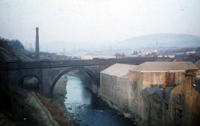


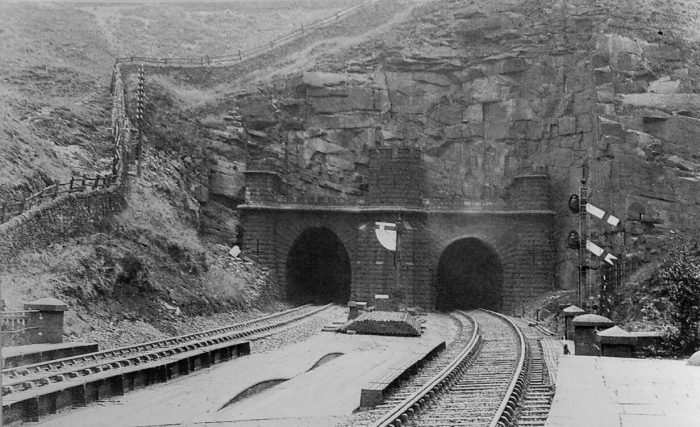
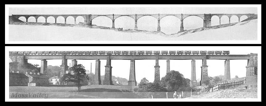 Dinting Vale Viaduct – at the top, the original viaduct, at the bottom, the later replacement.
 The following are links to information about the line which became part of the
  I am reading a book by Bill Laws: “Fifty Railways that Changed the Course of
 However, this principle of responsibility for one’s workers was usually ignore by Victorian entrepreneurs and business leaders: “What use had a mill owner for some eight-year-old girl who, through her own carelessness, lost her hand in a machine? Why should a railway company be responsible for a navvy’s family, when the man died, dead drunk, in a tunnel collapse? And why should the shareholder, risking his capital on such a brave enterprise as
 However, “although no railway man was censured over the Wood-