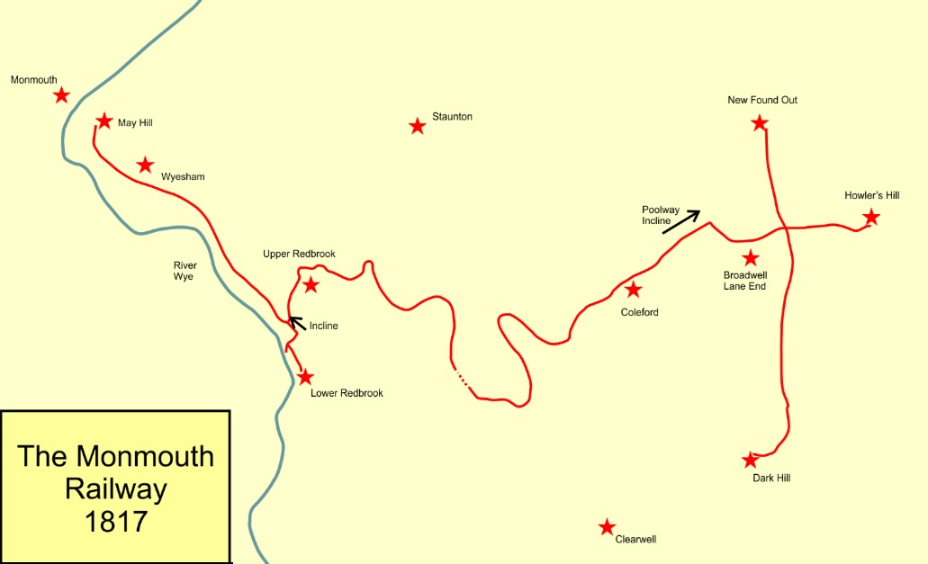
The Coleford Branch between Monmouth and Coleford replaced an earlier tramroad. The Monmouth Tramroad, linked Monmouth with Coleford and opened in 1810. It was the first rail transport in the immediate area.
Wikipedia tells us that the “Monmouth Railway Act was a Parliamentary act from 1810 (50 Geo. 3. c. cxxiii) that authorized the construction of a 3 ft 6 in gauge plateway, a type of early tramroad, from mines east of Coleford to May Hill in Monmouth, running through Redbrook. The purpose was to create a toll road for carriers to transport coal and iron ore, but it would not be operated by the company itself. The line opened in stages between 1812 and 1817.” [4]
For just under half a century this was the only ‘railway’ serving Monmouth. This was true for even longer in respect of Coleford.
It is of interest that this line was originally planned to be at the core of a significant network. It had a long tunnel near Newland and is thought to have been the first railway to include a paying passenger service within its Act. [1]
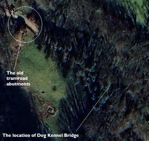
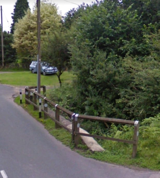
The original tramway bridge (pictured towards the end of this short article) was a low timber girder on stone abutments crossing a minor road serving a couple of farmsteads. This created a large loop up this side valley, which initial plans for the railway involved amputating and replacing with a gently curving viaduct.
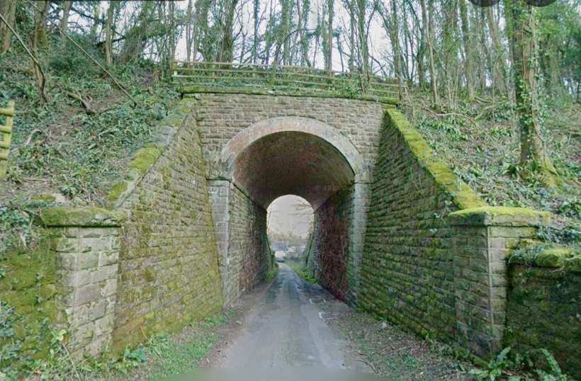
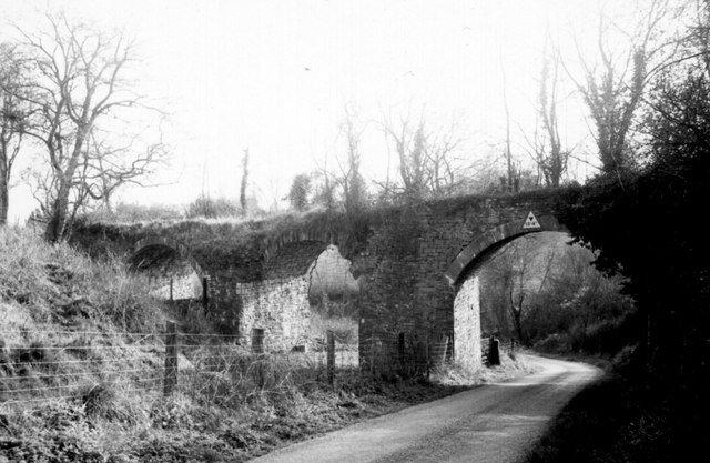
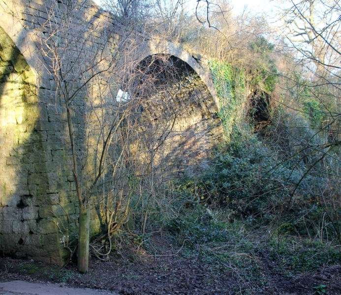
Viaducts are expensive, however, and taking a straight course means going a shorter distance and consequently trains would have to climb more steeply. So the viaduct was dropped from the plans and replaced by a huge embankment which made a smaller loop up the side valley. Through this embankment passed the new bridge for the minor road. Although it is a rather large structure (particularly by single arch standards), the top of the arch is still well below the top of the embankment, which carried a minor single track railway. It now carries an overgrown trackbed which is about the same width as the road below. The railway was built to last and, 92 years after the last train to Monmouth from Coleford, the Dog Kennel Bridge remains in excellent condition.
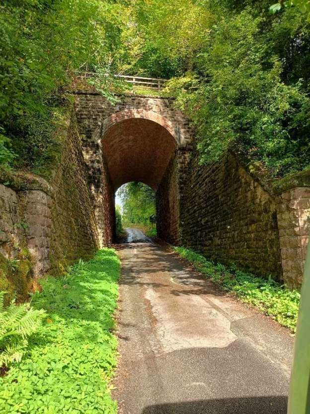
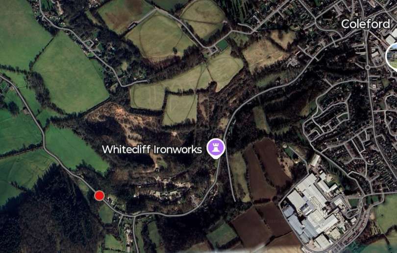
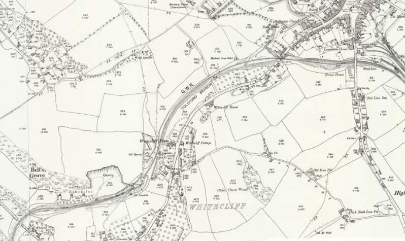
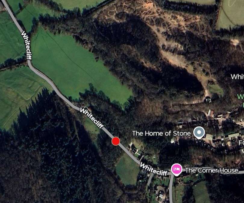
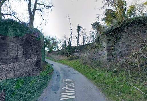
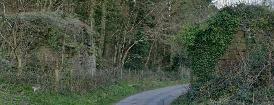
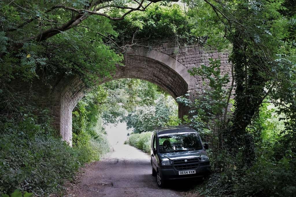
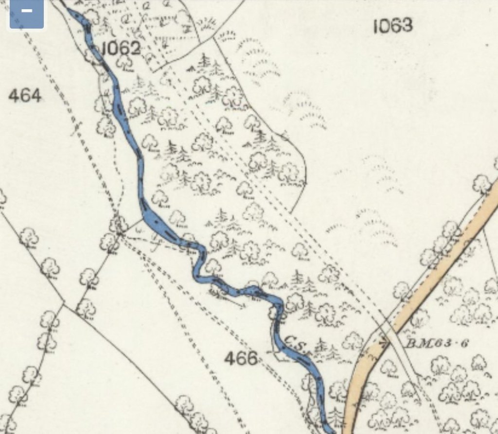
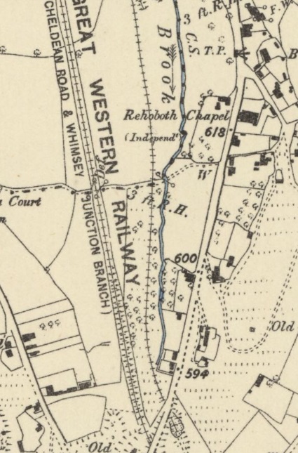
Dog Kennel Bridge, seen from the Northwest on Whitecliff. The featured image at the head of this article is a photograph taken by me on 3rd September 2025. It shows the same structure, seen from the Southeast on the same minor road. The featured image is repeated below. [Google Streetview, March 2025]The featured image for this short article is a photograph of Dog Kennel Bridge as seen from the Southeast. The bridge is unusual, being more like one span of a tall viaduct than a single-span arches bridge. [My photograph, 3rd September 2025]The red dot marks the location of Dog Kennel Bridge. The line of the branch can be made out as two parallel lines of trees which pass to the West of the ‘flag’ marking the position of Whitecliff Ironworks. [Google Maps, September 2025]The extract from the 25″ Ordnance Survey of 1900, published in 1902, shows the location of Dog Kennel Bridge in relation to the small town of Coleford. The bridge is in the extreme bottom-left of the map extract. Coleford’s two adjacent stations feature in the top-right of the map extract. [2]The red dot marks the location of Dog Kennel Bridge. [Google Maps, September 2025]The 25″ Ordnance Survey of 1900, published in 1902, shows the GWR single-track line crossing Dog Kennel Bridge. The earthworks for the older Monmouth Railway are visible running across the map extract on the South side of the GWR line above Whitecliff Villa, passing under the GWR line to head further up the valley before curving tightly over the road. [3]
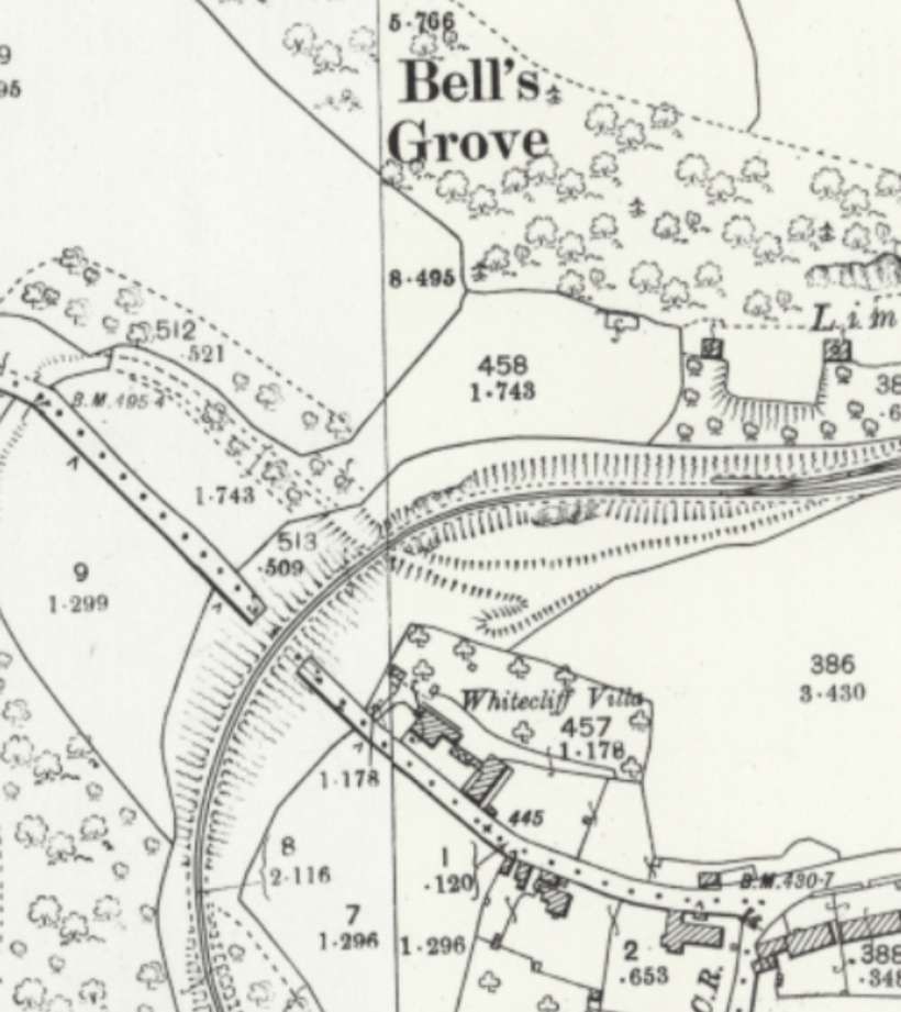
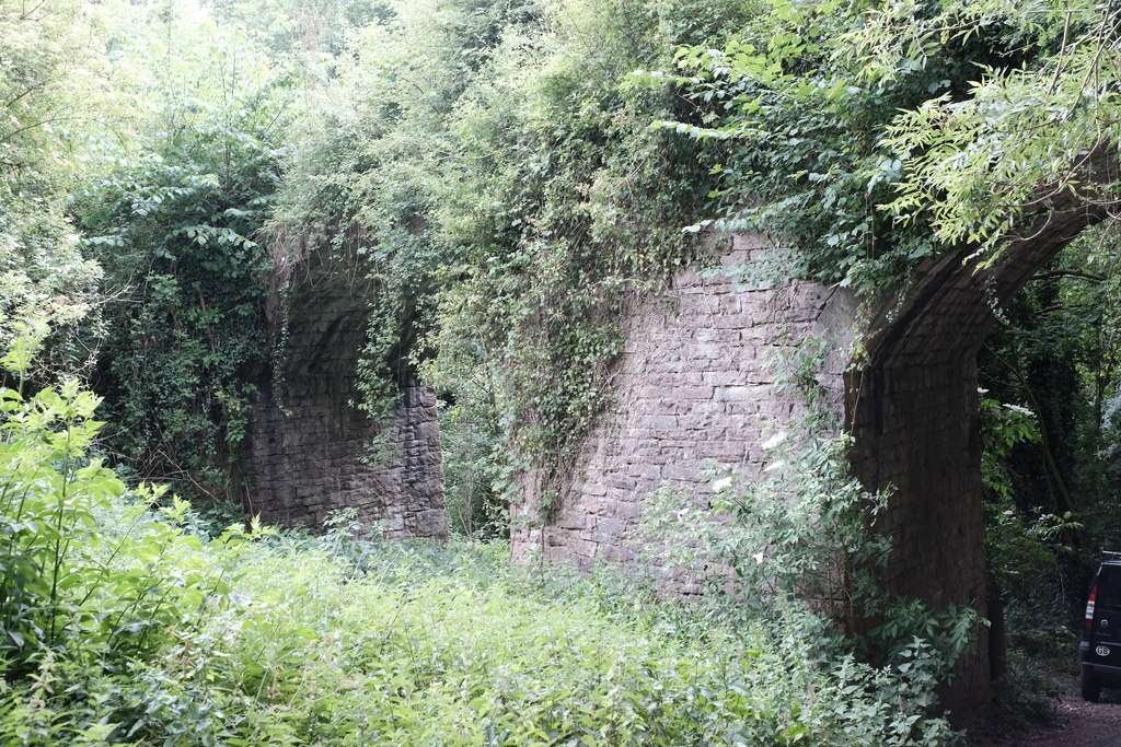
Dog Kennel Bridge carried the Coleford Railway, which ran from Wyesham Junction, near Monmouth, to Coleford, over a minor road between Whitecliff and High Meadow Farm. Construction of the line began in 1880, the contractors being Reed Bros & Co. of London, and it was opened on 1st September 1883. In common with other underbridges on the line, Dog Kennel Bridge is predominantly of stone, but the arch is made of brick. It has massive stone abutments and wing walls. The smaller stone bridge abutments of the Monmouth Railway, which the Coleford Railway replaced, are still visible about 100 metres up the lane (SO 56321007) where the old tramroad crossed the valley on a much sharper curve. [5]
The abutments of the tramroad bridge remain on either side of Whitecliff. This is how they appear from the Southeast. [Google Streetview, March 2025]The tramroad (Monmouth Railway) bridge abutments seen from the Northwest. [Google Streetview, March 2025]The relative positions of the older tramroad bridge and Dog Kennel Bridge. [Google Earth, September 2025]
The GWR’s Coleford Branch closed by 1st January 1917, most of the track soon being lifted for the war effort. [5]
Reading the November 1899 edition of The Railway Magazine, I came across an article about railways and tramways in the Forest of Dean … ‘The Severn & Wye Joint Railway’ by E.A. Clark. [1]
The article from 1899 adds something to the series of posts already made about the Forest and it railways
Clark says that “it was in the year 1809 that the initiative of the Severn and Wye took place. It had long been felt that there was great commercial scope in the Forest of Dean, and in this year Parliament sanctioned the construction of a tram road through the district. The undertaking was incorporated by the name of the Lydney and Lydbrook Railway Company, ‘for the purpose of making a railway or tramway from the River Wye at Lydbrook to the River Severn at Lydney, with various branches to serve the collieries in the Forest of Dean’. The Company finding their undertaking not complete, owing to there not being proper accommodation at Lydney for the export of coal, etc., in the following year (1810) obtained power by an Act of Parliament for the construction of a canal (over one mile in length) and docks or basins at Lydney to communicate with the River Severn, and the name of the Com- pany was changed by the same Act to the Severn and Wye Railway and Canal Company.” [1: p434-435]
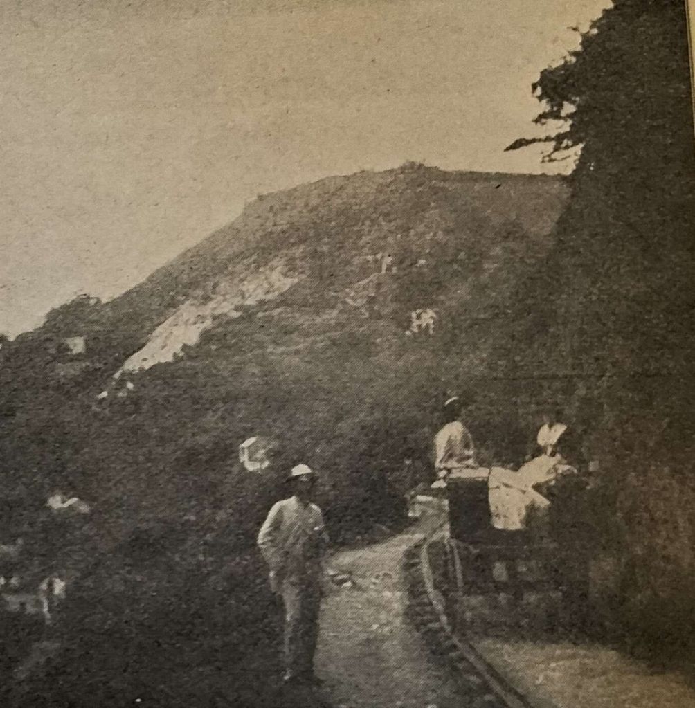
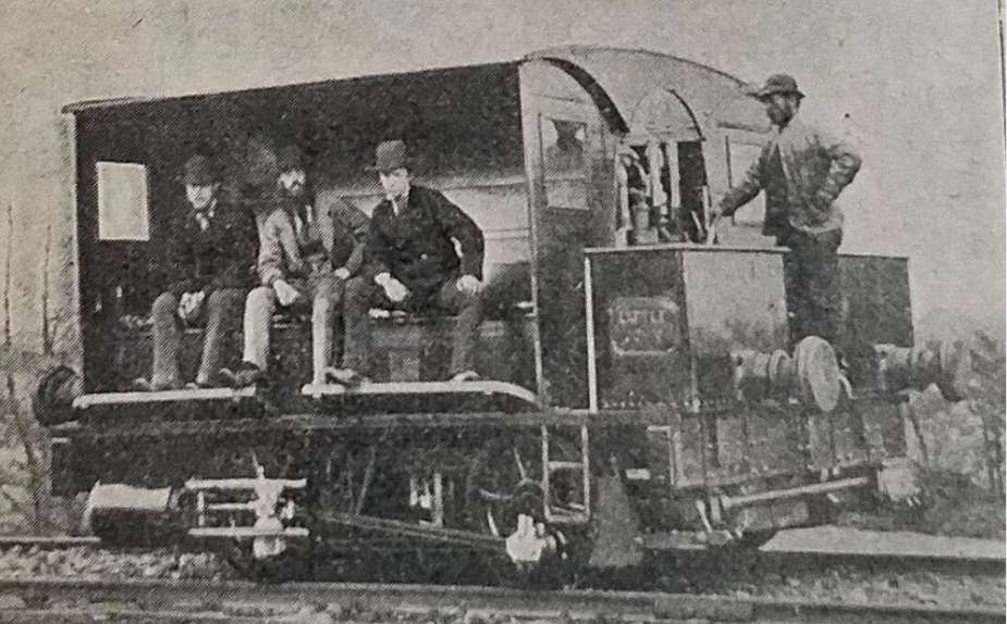
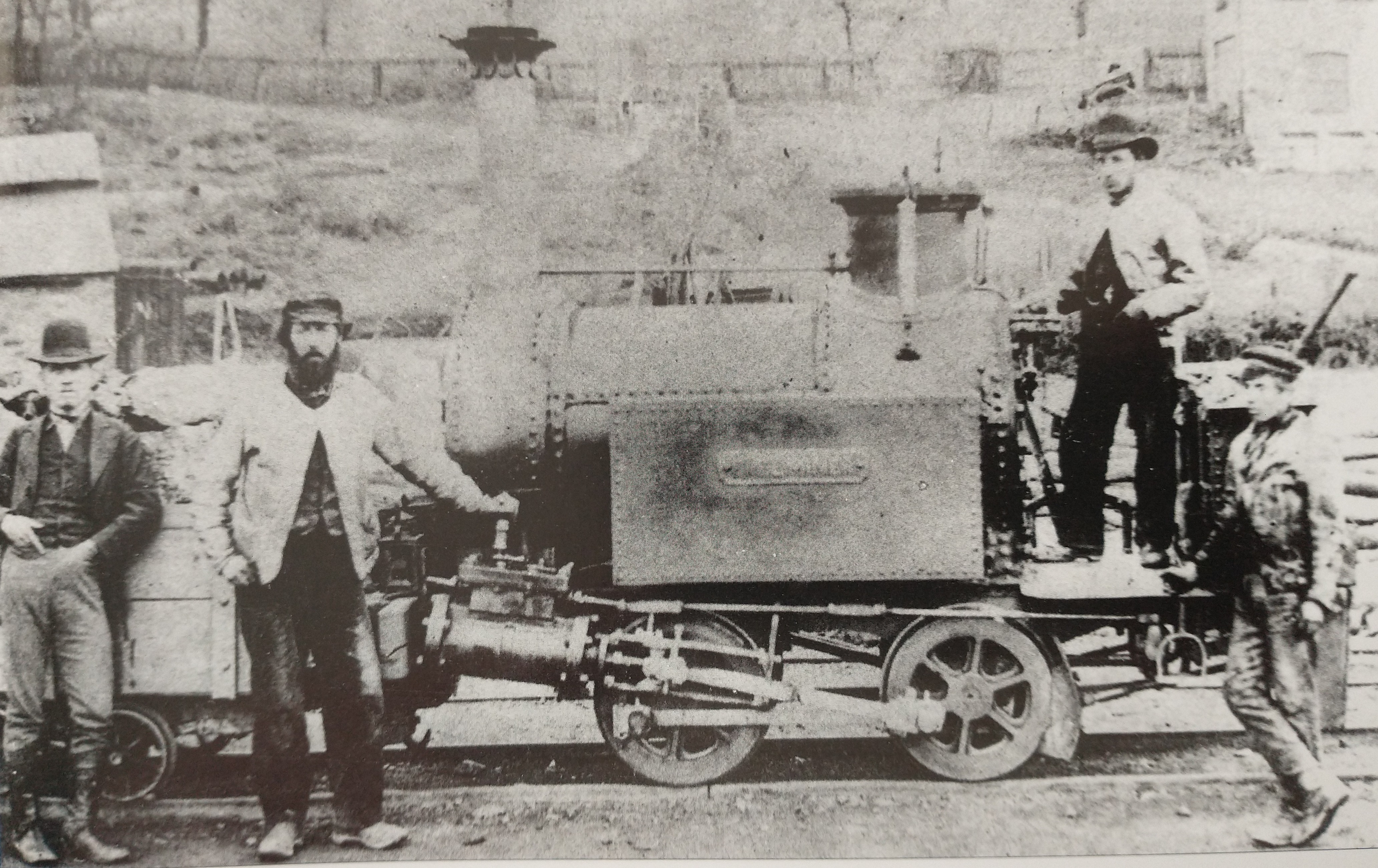
A Horse Drawn Vehicle sitting on the Tramway. The stone sleeper and rail construction is evident in this image. The vehicle looks to be a passenger carriage which has the correct wheel-spacing for the track gauge – probably not typical of the routine use of the Tramway! [1: p434]
Clark goes on to tell us that “the cost of construction of the tramway was nearly £90,000. The tramway was laid with tram plates and worked by horse power until the year 1865, when the first locomotive engines were used. From 1810 to 1868, the concern worked very satisfactorily and good dividends were paid. The Great Western Railway Company had constructed a railway on the broad gauge principle to the Forest at one or two points, and this rendered it necessary for the Severn and Wye in 1868 to lay down a broad gauge railway upon that part of their undertaking which lies between the South Wales Railway (Great Western Railway) at Lydney and Wimberry Slade near to the station now known as Speech House Road. Parliamentary authority was obtained to confirm this and to extend the line from Wimberry Junction to Cinderford, also to construct a very important branch, known as the ‘loop Line’ which runs from a point known as ‘Tufts’ between Lydney and Whitecroft on the main line, passing round the eastern side of the forest with sidings to the various collieries, and meeting the main line again at a point known as Drybrook Road, where there is now a passenger station. The loop line is 6 miles 55 chains.” [1: p435]
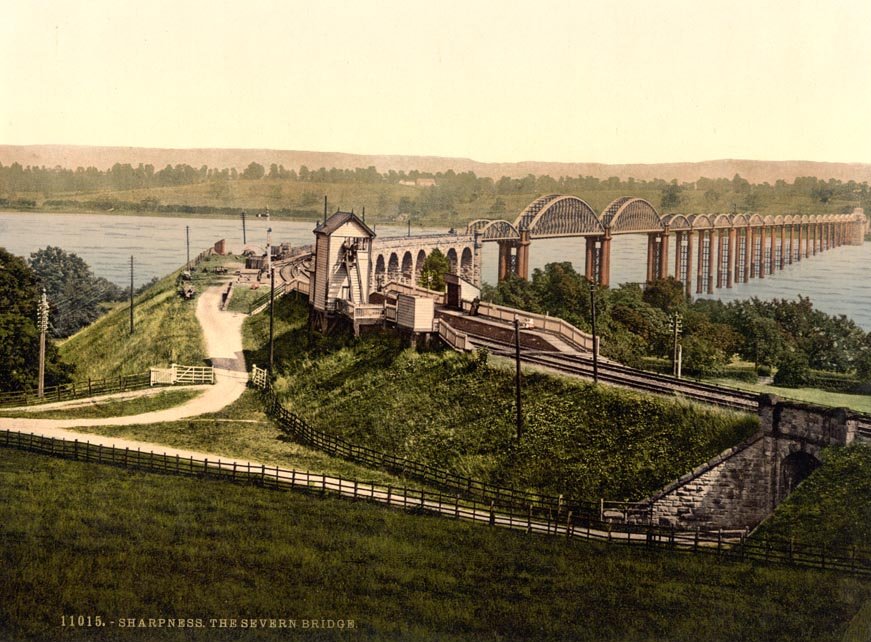
Clark continues: “The following year, a further Act empowered the Company to convert the tramway on the Lydbrook section to a railroad, with connection with the Great Western Railway at Stowefield, now known as Lydbrook Junction. In 1872, the tramway to Milkwall was substituted by a railway from the main line at Parkend with an ex-tension to Coleford. In 1875 the ‘Foresters’ (as the natives of the district are called) had their first experience of riding behind a locomotive engine. For it was in 1872 that an Act of Parliament was passed, which sanctioned the Severn and Wye Railway conveying passengers. … The year 1872 was a very important one to the Foresters, for in addition to the powers obtained as above described, the Severn Bridge Railway Company [was] incorporated for the purpose of making a railway from the Severn & Wye Railway and the Great Western Railway at Lydney across the River Severn to Sharpness Docks … and the Midland Railway.” [1: p435-437]
The Severn Bridge Railway
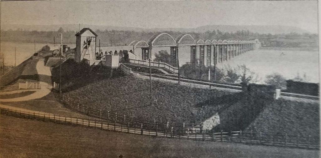
“The Severn Bridge was opened for passenger traffic on 17th October 1879. That year, the Severn & Wye Railway & Canal Company amalgamated with the Severn Bridge Railway, and was incorporated under the name of the ‘Severn and Wye and Severn Bridge Railway Company’. This new departure was not a financial success, and the most important Act had yet to be passed, and that was in 1894, for vesting in the Great Western and Midland Railway Companies the whole undertaking of the Severn and Wye and Severn Bridge Railway Company (at a cost of over £447,000), and by the same Act the Midland Company were empowered to transfer to the joint Committee (fe. the Great Western and Midland Com-panies), their branch known as the ‘Gloucester and Berkeley New Docks Branch’ rom Sharp- ness to Berkeley Road, joining the Midland main line.” [1: p437]
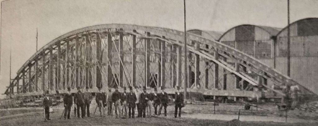
One of the large soans of the Severn Bridge during construction at Liverpool. [1: p439]A postcard view of the Severn Bridge with Severn Bridge Station in the foreground. [1: p439]
There was much local opposition which meant compromise was necessary. Several conditions were therefore enjoined in the Act, one was the extension of the railway into Cinderford Cinderford, should be extended into the town.
At the time of the writing of the article (November 1899) there were over 40 collieries; two large tin-plate works; several iron ore mines; and numerous quarries. “Total traffic carried by Severn and Wye Railway Company:- 1875, 492,931 tons; 1890, 674,545 tons; 1898, 1,149,631 tons. Of course the great increase in the 1898 figures, as compared with the 1890 figures, [was] due to some extent owing to the traffic from Sharpness not being accounted for in the 1890 figures – the Berkeley Branch then belonged to the Midland Railway. … Passenger traffic [had] doubled during the last two years as compared with ten years [before].” [1: p438-439]
‘Little John’, its Class Mates and Later Locos
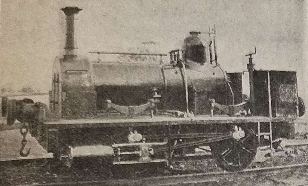
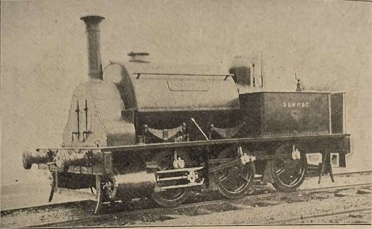
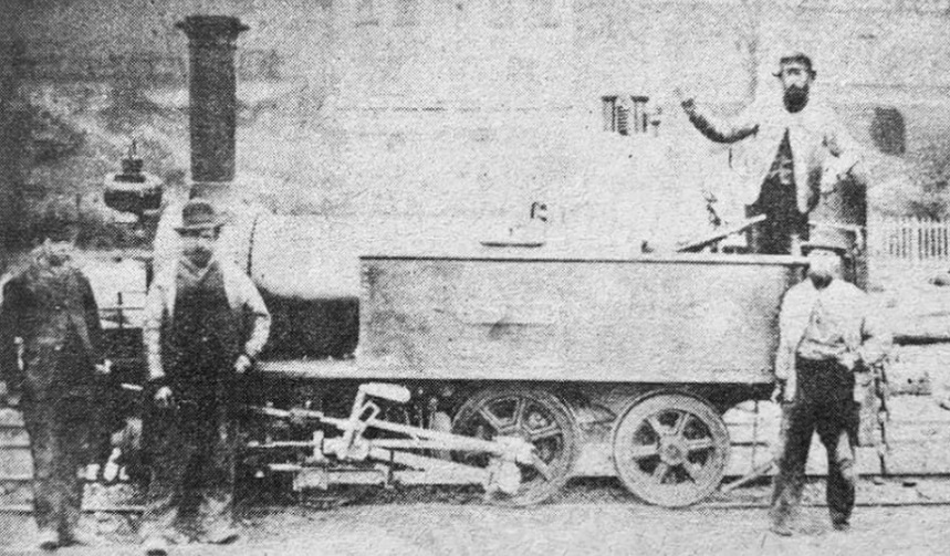
Clark provides two pictures of what he says was the first broad gauge locomotive belonging to the Severn & Wye Railway (‘Little John’). The pictures below show it as an 0-4-0WT locomotive. It is possible that, a few years earlier, the Company purchased a single loco on a trial basis. “This locomotive was [possibly] ‘Little Nell’, an 0−4−0 saddle tank, the first locomotive built at the Boyne Engine Works, Leeds, by Manning, Wardle & Company, and delivered to Sheepbridge on 5th February 1859.” [4]
Clark indicates that these photographs depict ‘Little John’, the first broad gauge locomotive owned by the Severn & Wye Railway Company. The loco shown was an 0-4-0WT loco. [1: p437]
Some notes on the Western Thunder website suggest that ‘Little John’ was one of three locomotives of the same design which were supplied to the Severn & Wye Railway (S&WR). The three locos were ‘Will Scarlet’, ‘Little John’ and ‘Alan-a-Dale’. The writer of those notes assumed that ‘Little John’ and its class-mates were 0-6-0WTs and mentions that the three locos were divided between the GWR and MR when the S&WR was taken into joint ownership in July 1894, ‘Will Scarlet’ (FJ 122) became GWR 1356, ‘Little John’ (FJ 140) became Midland 1123A, and ‘Alan-a-Dale’ (FJ 157) became Great Western 1355. [3]
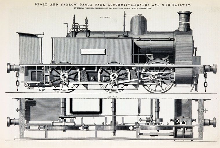
It seems from the discussion on that website that six 0-6-0T locos were purchased by the S&WR, these were of various designs from different suppliers. Fletcher Jennings supplied locos as shown below.
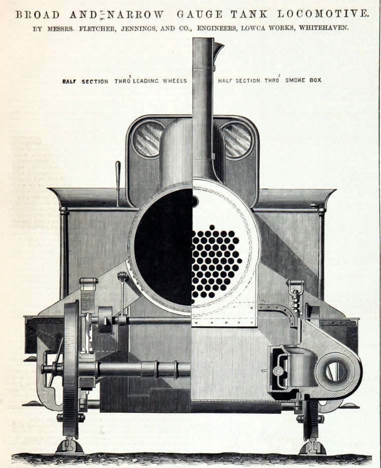
Illustrations showing details of the six 0-6-0T locomotives supplied to the Severn & Wye Railway by Fletcher Jennings. These illustrations and the quoted text below appeared in the 30th April 1869 copy of ‘The Engineer’ [2]
The notes associated with the two images above say: “This somewhat remarkable engine – illustrated above … which is of the broad, or 7ft. gauge, has been specially constructed with a view to its being readily altered if occasion should require to suit the ordinary narrow gauge, and with as little expense as possible. To this end the axles are made, as will be seen by reference to the plan and section, with a third journal and wheel seat in positions proper for 4ft. 8.5 in. gauge, the coal-box, water tanks – except the one under footplate – fire-box, smoke-box, side foot-plates, and other parts are all made to suit the narrow gauge, so that when the alteration, which is anticipated, is required, little more is needed than to shorten the frame stays and buffer beams, remove certain brackets which support the fire-box and smoke-box, place the frames nearer together, shorten the axles, and remove one of each pair of wheels to its inner wheel seat. The cylinders are 14in. diameter, and the stroke is 20in.; the wheels 4ft. diameter, and extreme wheel centres 11ft. 3in.; tires, piston-rods, motion bars, crank pins, &c., are of steel. The fire-box is 3ft. 3in, long, 3ft. 3in. broad, and 4ft. 10in. deep. The boiler barrel, which is telescopic, is 3ft. 6in. mean diameter, and 8ft. Shin. long; the tubes are of brass . long, 2in. outside diameter, and 105 in number. … The total weight with a full supply of water and fuel is 28 tons 6 cwt., and this is distributed as follows:- Leading wheels, 9 tons; driving wheels, 9 tons 1 cwt.; trailing wheels, 10 tons 5 cwt. With partially filled tank and coal-box, the weight is equally distributed on the wheels.” [5]
Another source on ‘rmweb’ provides the following notes which were sourced from the RCTS publication, ‘Locomotives of the GWR – Part 3’. “Severn and Wye loco history is not simple. … They started to get steam engines in 1865, when there was thirty miles of 3’8” tramway. By 1867 they had five locos, and decided to go broad gauge, converting three engines. Two broad gauge engines were obtained, but in 1872 they decided to go to standard gauge, so the five broad gauge engines were converted to standard. The S&WR amalgamated with the Severn Bridge Railway in 1879. A receiver was appointed in 1883, and the railway was taken over jointly by the MR and GWR in 1894. … The first five engines were Fletcher Jennings 1864, with flangeless wheels for the tramroad. 1-4 were 0-4-0WT, 2-3 being the ones that were converted, 1 becoming a canal dredger. 5 was an 0-6-0ST which also went through two gauge conversions. All these had gone by the time of the receivership.
The RCTS publication, ‘The Locomotives of the Great Western Railway Part 3 Absorbed Engines 1854-1921‘, details the following locomotives as well:
Robin Hood, Fletcher Jennings 1868, MR 1121A – was broad gauge originally.
Ranger 0-6-0 (rebuilt ST), GWR 1358 – very complicated history.
Raven 0-6-0ST, Boulton, 1876 – sold on.
Wye 0-4-0T, Fletcher Jennings, 1876 GWR 1359.
Sharpness, Vulcan, 1880 MR. 1124A.
Severn Bridge, Vulcan, 1880 GWR 1354.
Sabrina, Vulcan, 1882 MR 1125A.
Forester, Vulcan, 1886 MR 1126A.
Gaveller, Vulcan, 1891 GWR 1353.
Four locos were hired from Boulton’s siding at different times.
The net result of these different notes is that the 0-4-0WT loco shown in Clark’s article in the Railway Magazine is unlikely to be ‘Little John’. ‘Little John’ was probably one of the later 0-6-0T locos and may well not have been a broad gauge engine at any time during its working life.
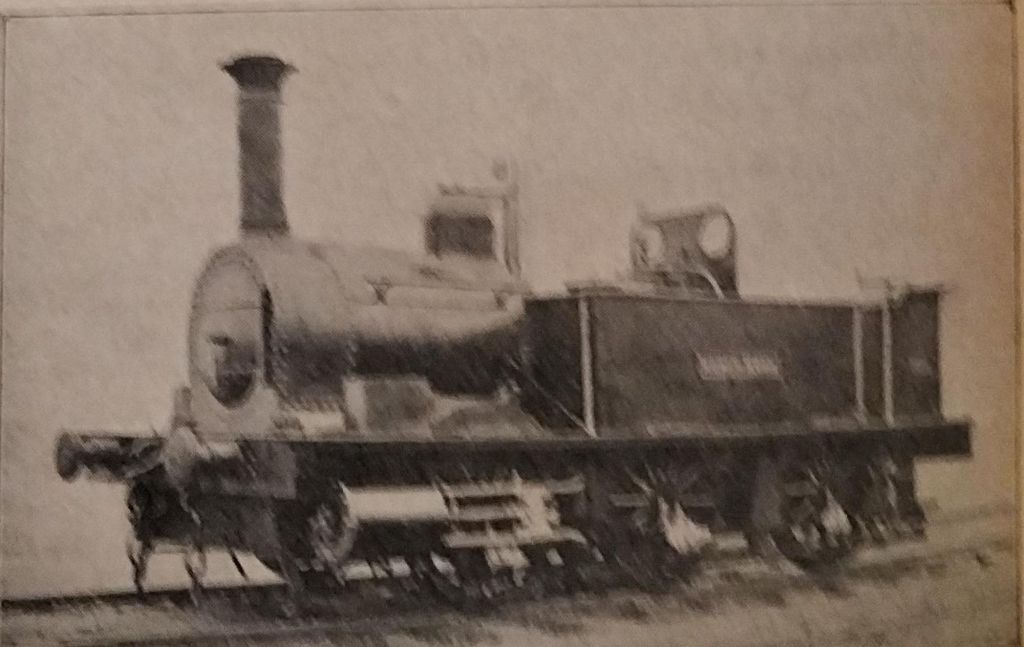
‘Forrester’, which Clark says was the first six-wheeled broad gauge locomotive of the S&WR. [1: p438] As the notes above suggest, ‘Forrester’ was actually one of the later purchases by the S&WR. [6]‘Robin Hood’ – Clark says that this was a six-coupled broad-gauge locomotive. [1: p438] The loco was built in 1868 as a broad-gauge locomotive. [6]
References
E.A. Clark; The Severn & Wye Joint Railway; in The Railway Magazine, London November 1899, p434-441.
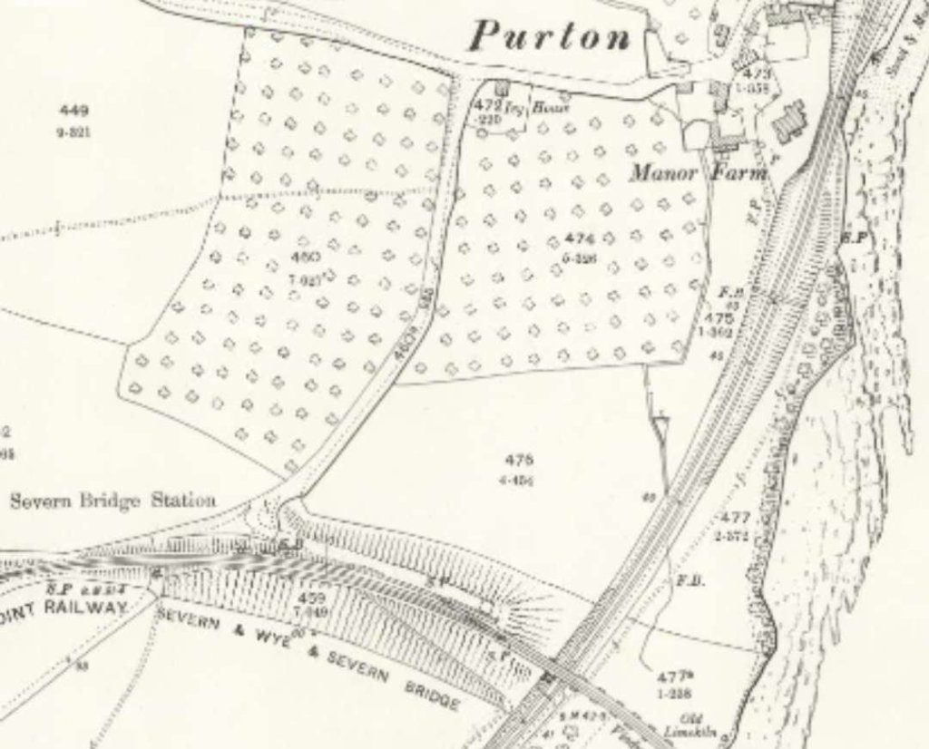
On the road between Purton and Etloe on the Northwest side of the Severn Estuary there is a railway viaduct. Seemingly it sits remote from any former railway. Although you might just be forgiven for thinking that it is a remnant of the Forest of Dean Central Railway, or even associated with the Severn & Wye Railway which ran close to, but to the South of, the hamlet of Purton.
The Severn Bridge Railway Station sat just to the South of Purton on the West Bank of the River Severn. [9]Purton sits just to the North of the Severn Bridge Station on the Severn and Wye Railway. This map extract comes from the 25″ Ordnance Survey of 1901. [10]
It is, in fact, the main remnant of a planned railway/tramroad – the Purton Steam Carriage Road! It can be seen on the map extract below which shows the viaduct just to the North of the hamlet.
Purton Viaduct appears at the top-left corner of this map extract. The hamlet of Purton is bottom-left. Purton Pill is just below the centre of the extract. Historically, there was a ferry across the River Severn at this location. This map extract comes from the 1879 25″ Ordnance Survey. In 1879, a footpath can be seen following the approximate line of the proposed railway. [11]
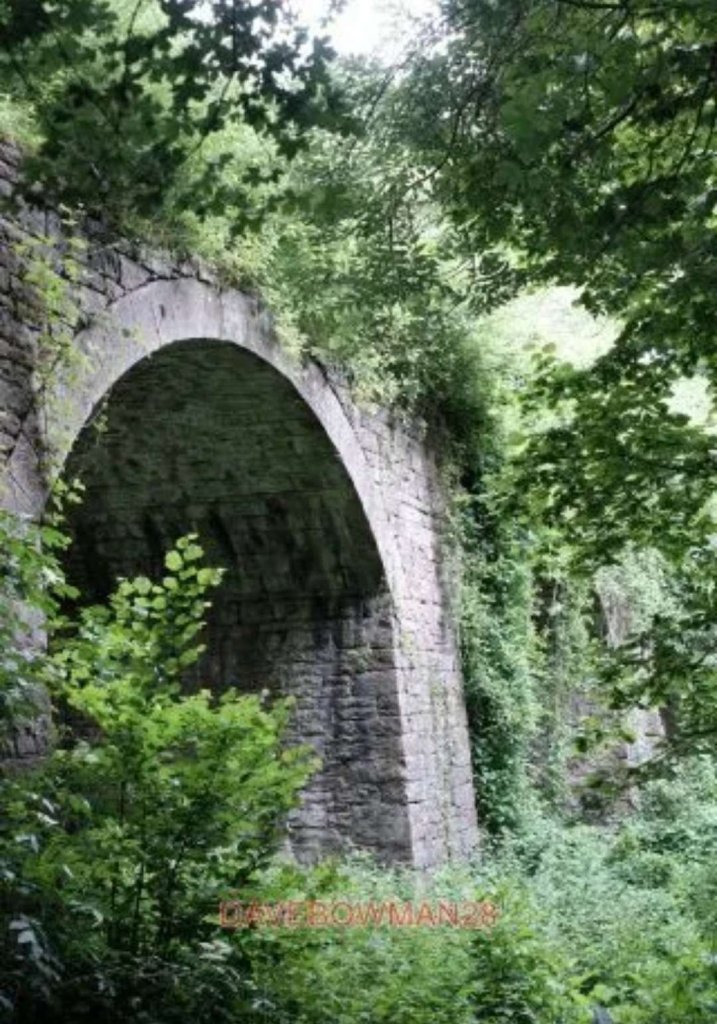
The viaduct was built, circa. 1832, of red sandstone rubble with dressed voussoirs. It has 3 arches of diminishing heights, its main pier is wedge shaped, so that the viaduct is slightly angled. The tallest arch spans the road. The centre arch is damaged on the NE side. Its Southeast wall continues as retaining wall for some distance. Part of the parapet survives at the north west end.
The viaduct is of considerable historical and industrial archaeological interest: the Purton Steam Carriage Road was planned in 1830, just a few years after the Stockton and Darlington Railway first ran in 1825.
Sadly, it was never to carry the goods it was intended for, but it seems to have had considerable effect on local politics at the time, and on later railway enterprises in the area.
“The finance was to come from a prominent local Iron-master, Charles Mathias of Lamphey Court, Pembrokeshire. The viaduct is the most tangible surviving evidence for an industrial scheme which would have involved the first crossing of the Severn on a moveable bridge.” [1]
The Purton Steam Carriage Road Company predated the Forest of Dean Central Railway and intended to build a line, 8 miles or so long, from a purpose-built dock at Purton Pill to the then-new Foxes Bridge Colliery in the Forest of Dean.
A scheme drafted earlier in the century was revived in 1830 and supported by a number of Forest industrialists. As we have already noted, “The promoter of the Parliamentary Bill, presented to Parliament in 1832, was one Charles Mathias, who was so confident of the Bill’s success that he purchased the required land and began construction of the line. Unfortunately, the Bill met strong opposition from the Commissioners of Woods, failed to make its second reading and was withdrawn. Mathias’ premature and misplaced enthusiasm had led to the construction of various bits of railway infrastructure.” [3]
The structures completed included:
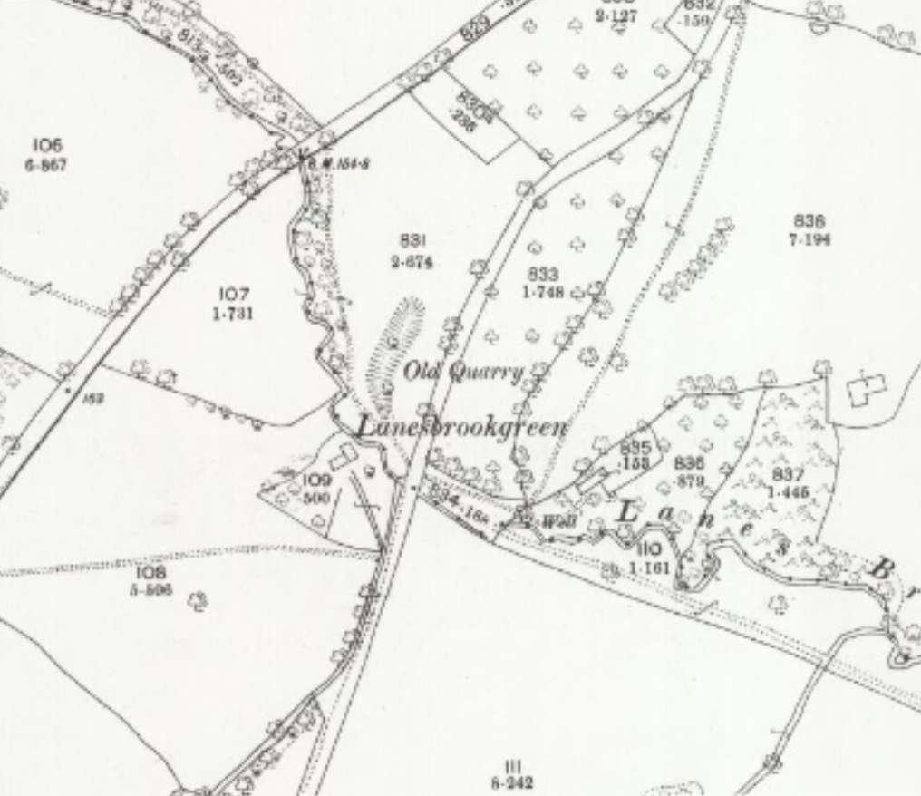
All or part of Nibley Hill Tunnel near Blakeney (the portals are each marked as “old quarry” on the 1892-1914 OS 25″ map);
Purton Viaduct is Grade II Listed by Historic England. It is recognised as being of “considerable historical and industrial archaeological interest”, but is suffering from the vegetation which has almost hidden it from view in places! [3]
The viaduct is noted in Neil Parkhouse’s, “Forest of Dean Lines and the Severn Bridge” which is the second volume in Lightmoor Press’, “British Railway History in Colour” series. [6]
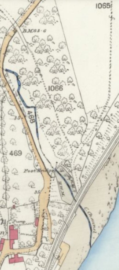
North of the Viaduct, the line of the Purton Steam Carriage Road can be followed on older maps, as the map extract below shows.
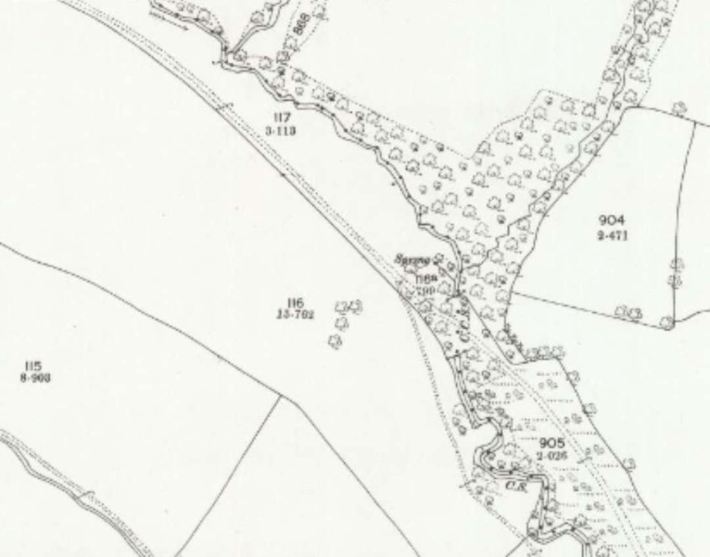
Purton Viaduct appears in the bottom-right of this map extract and the route of the planned Purton Steam Carriage Road can be seen as the double-dotted track heading Northwest from the viaduct. This extract is from the 1879 25″ Ordnance Survey. [11]The line of the proposed Carriage Road runs from bottom-right to top-left on this extract from the 25″ 1878/1879 Ordnance Survey. [12]The line of the proposed Carriage Road runs from the bottom-right towards the top-left on this extract from the 25″ 1878/1879 Ordnance Survey. Approximately at the centre of the extract the Ordnance Survey chose to name the made-made defile at Lanesbrookgreen as an Old Quarry. It is in fact the location of what was to be the Southern mouth of Nibley Hill Tunnel. [12]This slightly out of focus extract from the 25″ Ordnance Survey of 1878/1879 shows both the North and South ends of Nibley Hill Tunnel marked as Old Quarries. The road running North-South adjacent to the line of the northerly length of Nibley Hill Tunnel and then crossing its line to the North of the proposed southern portal is now the A48. [12]This composite image overlays modern satellite imagery over the 25″ Ordnance Survey from the turn of the 20th century. The defiles marking the proposed tunnel entrances can be made out at the top and bottom of this image. The A48 is easily made out. [14]
Nibley Hill Tunnel would have been 600 yards in length and would have taken the Purton Steam Carriage Road into the Forest of Dean close to the village of Blakeney.
The Purton Steam Carriage Road was one of two early proposed Tramroads in the Forest of Dean which were close to the line of what became the Forest of Dean Central Railway.
To the North was the proposed Moseley Green and Tilting Mill Tramroad which was intended to link the valley of Blackpool Brook with the outside world by connecting mines in the Moseley Green area with the Bullo Pull Tramroad. It was not pursued. Instead, in 1832, the Purton Steam Carriage Road was devised to access the Blackpool Brook valley. [13]
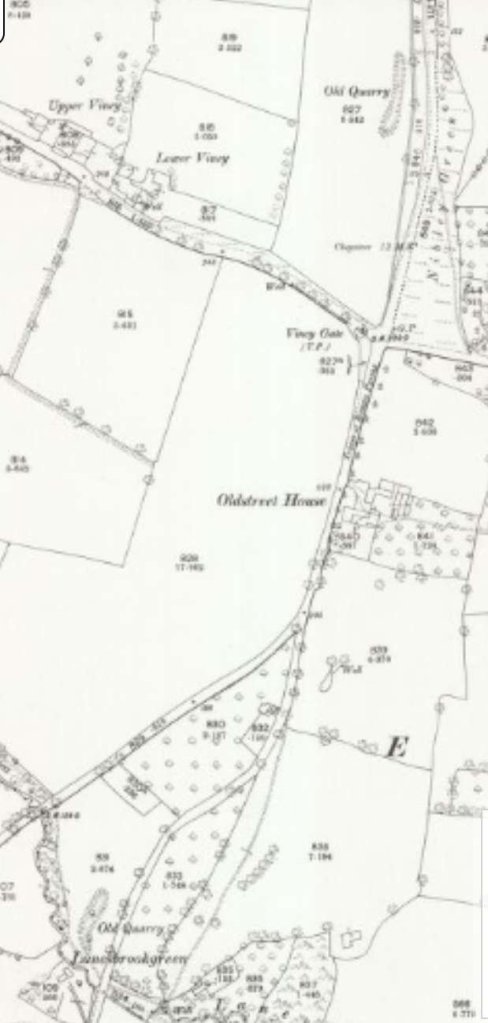
Its route North of Nibley Hill Tunnel is difficult to identify on the Ordnance Survey mapping of the late-19th and early-20th centuries.
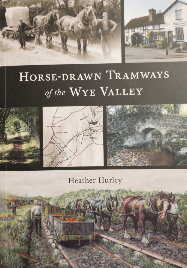
A great Christmas purchase from Rossiter Books in Leominster! (£12.99, ISBN 978-1-910839-60-7, Paperback, 176 pages, 242 x 171mm).NB: The images in this article are sourced from the internet.
Horse-Drawn Tramways of the Wye Valley [1] by Heather Hurley, published by the Logaston Press in Novber 2022, is an excellent introduction to the early tramways in the Wye Valley. A short-lived transport system of horse-drawn waggons on rails, operating from the late eighteenth century to the introduction of steam locomotives in the middle of the nineteenth century, primarily used for transporting goods such as coal and wood.
Heather Hurley explores all of the tramways known to have existed in and around the Wye Valley from Kington, through Brecon and Hay to Abergavenny, Monmouth, the Forest of Dean and Hereford; the routes taken, the companies that built and ran them, and the people who used them. She draws on extensive research of Tramway Company archives, Acts and ledgers, maps and plans, newspapers and journals, archaeological reports, books and illustrations, as well as detailed fieldwork.
As the back cover states, Hurley’s book is richly illustrated and offers captivating insights into early nineteenth-century transport history, trade routes and the beginnings of the steam railways on the Welsh border.
Heather Hurley has a keen interest in local history. She has written several books, including ‘The Scudamores of Kentchurch and Holme Lacy’, ‘The Story of Ross’ and ‘Landscape Origins of the Wye Valley’. She is planning to produce a parallel volume about the railways of the Wye Valley in due course.
Horse-Drawn Tramways of the Wye Valley is an easy to read but well-researched introduction to tramways in the Southern Marches. Evidence of Hurley’s detailed research can be found in the extensive notes which support each chapter. Solid research does not, however, mean that this is primarily a dry academic book. It is accessibly produced with appropriate illustrations and a confident narrative.
The first chapter gives an overview of transport systems which predated the introduction of tramways. A chapter is devoted to the development of the horse-drawn tramways which includes an important section focussing on the horses used, before the more usual engineering matters of waggons, rails and stone ‘sleepers’ are covered.
Two further chapters cover some local tramways of interest and the coming of steam-power.
The history of each of the major lines is recounted is some detail, each route is surveyed and details of goods carried are provided. For each line, some notes are provided on remains visible in the 21st century and on where documents recording its life can be found.
The extent of the coverage in a paperback book of 176 pages is to be commended. No doubt some readers will want to look at one or more of the routes portrayed in more detail than is possible in a book of this nature. The book might have benefitted from the addition of maps to support the detailed route descriptions provided towards the end of each of the major chapters. The book is, however, a wonderful introduction to its subject and has been an excellent post-Christmas read!
I wholeheartedly recommend this book to anyone interested in the industrial history of the Welsh Marches and the Forest of Dean. Anyone interested in the history of tramways/tramroads in the UK would do well to purchase a copy, not only for the informative narrative and illustrations but also for the detailed endnotes.
The Logaston Press takes its name from the hamlet of Logaston, in the beautiful countryside of rural north-west Herefordshire. It was here that Logaston Press was set up by Andy Johnson in 1983, and later run by Andy together with his wife Karen.
In 2018 Andy and Karen handed over the reins to Richard and Su Wheeler, who now run Logaston Press from the nearby village of Eardisley.
Logaston Press publishes books on local history, landscape, archaeology, architecture, and a range of walks guides – all focussed on the ‘Logaston heartlands’ of the Southern Marches: Herefordshire, Shropshire, Worcestershire and Gloucestershire, Radnorshire, Breconshire and Montgomeryshire.
In almost four decades, Logaston Press has published more than 350 titles, with more than 100 books currently in print. Its books are beautifully produced, ethically printed and reasonably priced. They are are a pleasure to own.
Logaston Press is rooted in the people and places of the Southern Marches and is dedicated to publishing books that explore and illuminate this extraordinary part of the world.
References
Heather Hurley; Horse-Drawn Tramways of the Wye Valley; Logaston Press, Eardisley, 2022.
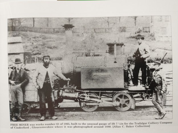
The featured image above shows the locomotive ‘Free Miner’ which was Works No. 61, at the Lilleshall Company Works, it was delivered to Trafalgar Colliery in February 1865 for use on the Tramway. The picture comes from Bob Yate’s book about the Lilleshall Company locomotives and railways, (c) Alan C. Baker Collection. [5: p55]
A little while ago, I wrote an article about the Trafalgar Colliery in the Forest of Dean and as part of that article started to cover Brain’s Tramway. That article can be found at:
In that article, I noted that Brain’s Tramway was built soon after the opening of the colliery to connect to the Great Western Railway’s Forest of Dean Branch at Bilson [1] The single line of 2ft 7.5in gauge utilised edge rails laid on wooden sleepers and ran east from the colliery, turning south-east at Laymoor, and terminated 1.5 miles away at interchange sidings at Bilson. It would appear that the authorisation for its construction was a Crown licence for ‘a road or tramway 15 feet broad’ dated May 1862. The date the line was opened for traffic is unknown as, although the first of three locomotives used on the tramway was built in 1869, it is possible that it may have been horse worked before this date. [2]
I noted that the colliery appeared to have owned three locomotives: ‘Trafalgar’ and ‘The Brothers’ were 0-4-2 side-tank locos. The third locomotive was ‘Free Miner’, an 0-4-0 side-tank. The locomotive ‘Trafalgar’ continued in use until 1906, working on the northern extension of the tramway, built in 1869, to the Golden Valley Iron Mine at Drybrook. [2] we will return to these three locomotives later in this article.
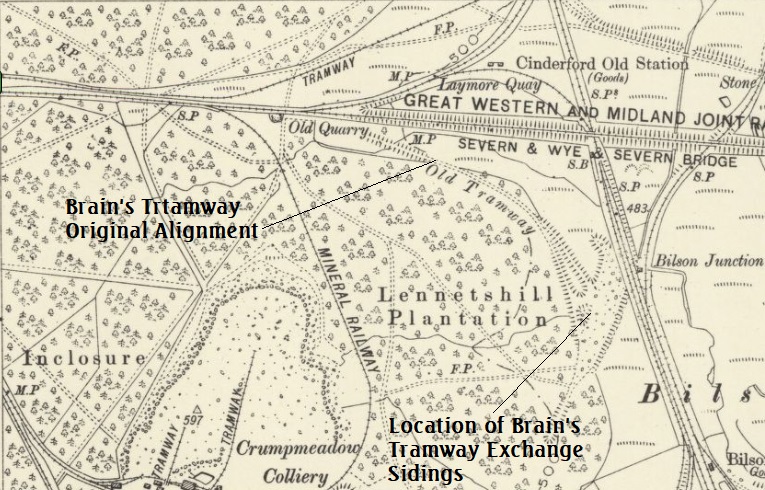
6″ OS Map from 1901 showing both Mr Brain’s Tramway and the standard-gauge sidings of the Colliery and their connection to the Severn & Wye Railway close to Drybrook Road Station. [16]The extent of Mr Brain’s Tramway when first built to the Bilson Exchange Sidings. The point of conflict with the Severn and Wye near Laymoor (as mentioned below) can easily be picked out on the map extract. [3]
Tramway locomotives hauled trains of 20-25 trams of coal on each trip along Brain’s Tramway to Bilson, until 1872 when the Severn & Wye built their branch to Bilson. This crossed the tramway on the level near Laymoor and resulted in the need for the two companies to negotiate an acceptable coexistence. This became more urgent once the Servern and Wye extended beyond Drybrook Road an when, in 1878, passenger trains began running over the crossing.
Although a connection had been made to the Severn and Wye Railway in 1872 [1] at a point between Serridge Junction and Drybrook Road station, a large element of Trafalgar’s output still travelled along the tramway to Bilson. [2]
In my article about the colliery, I noted that in 1872, agreement was reached between the Severn and Wye and Trafalgar Colliery for sidings to be put in to serve the colliery screens. Soon after the Mineral Loop of the Severn and Wye was completed, a loop off the main line was installed and sidings were laid. However, the Severn and Wye was dismayed to note at a later date that Trafalgar Colliery was still making heavy use of the tramway.
The Lightmoor Press website comments that:
“Finally, in December 1889, an agreement was entered into between the Severn & Wye and the Trafalgar Colliery Company who, it was said, ‘are desirous of obtaining railway communication to Bilson Junction in lieu of their existing trolley road.’ It was agreed that on or before 31st March 1890 the colliery company would construct new sidings and the railway company would lay in a new junction at Drybrook Road. Although the new junction was a quarter of a mile closer to Drybrook Road than the old sidings, the mileage charge was to remain the same. The accommodation, on approximately the same level as Drybrook Road station, was to be constructed so that traffic to and from the Great Western would be placed on a different siding to that which was to pass over the Severn & Wye system. For taking traffic to Bilson Junction for transfer to the Great Western the colliery was to be charged 7d per loaded wagon, although empties were to pass free. The transfer traffic also had to be conveyed ‘at reasonable times and in fair quantities so as to fit in with the ordinary workings of the Railway Company trains’. The new sidings were brought into use on 1st October 1890.” [2]
The Lightmoor Press article notes that this “agreement finally resulted in the abandonment of the length of the tramway from Laymoor to Bilson Junction. Two of the colliery’s narrow gauge locomotives were put up for sale, neither sold.” [2]
A couple of things:
1. More about the locomotives in use on Brain’s Tramway
Further research has resulted in a bit more information about the locomotives that worked on the Tramway. ….
These locomotives were built by the Lilleshall Iron Co. The first, ‘Free Miner’ was built in 1865. I came across the locomotive in a book by Bob Yate, “The Railways and Locomotives of the Lilleshall Company.” [5] I have recently (2022) moved to Telford and I have been reading a number of publications about the industry, canals, tramways and railways of the area. The Lilleshall Company was the major player in the industrial scene in the Telford (East Shropshire) area throughout the 19th century and much of the 20th century. It had its own system of canals, tramways and railways. Ultimately it had a large roster of industrial locomotives. In the mid-19th century, the Lilleshall Iron Co. built locomotive for others. Bob Yates features ‘Free Miner’ in his list of locomotives built by the Lilleshall Company.
‘Free Miner‘ was Order No. 61 at the Lilleshall Works. It was built in 1865 to a 2ft 7.5 in gauge. It was an 0-4-0T locomotive which the Industrial Railway Society Handbook records as having 8″ x 14″ outside cylinders. It was delivered new in February 1865 to Cornelius Brain, Colliery, Cinderford, Gloucestershire. It was possibly scrapped in 1906. [5: p52]
The date of delivery calls into question the comments above about the date of opening of the line as we now know that a single locomotive was available early in 1865, rather than in 1869. Given that approval for the construction of the Tramway was only given in 1862, it may well be that it was only operated under horsepower for a very short period.
‘Free Miner’ was Works No. 61, at the Lilleshall Company Works, it was delivered to Trafalgar Colliery in February 1965, (c) Alan C. Baker Collection. [5: p55]
Bob Yate also provides information about the other two locomotives ‘Trafalgar’ and ‘The Brothers’. ‘Trafalgar‘ was supplied to the colliery in 1869. Bob Yates provides the following information: Gauge 2ft 7.5in; Works No. 140; 0-4-2T with 8″ x14″ outside cylinders. It was delivered new in April 1869. Yate comments that an early photograph of this locomotive reveals that it was supplied without a cab, and that the trailing wheels were only about 6″ diameter less than the driving wheels. The safety valves were mounted on a ‘haystack’ firebox. Scrapped c 1906. [5: p56] Both Yate [5: p56] and Lightmoor [2] say the the locomotive was of an 0-4-2T wheel arrangement. What seems not to have been noted is the very short wheel-base of the locomotive as can be seen in the image below. Also evident is the minimal difference in size between the driving wheels and the trailing wheels that Yate refers to.
‘Trafalgar’ which was delivered to the colliery in April 1869. [4]
‘The Brothers‘ was delivered new by the Lilleshall Company in August 1870. It was Order No. 159 on the Lilleshall Company books. Yate records this as a sister locomotive to ‘Trafalgar’ with the same details/dimensions. He notes, however that the Register of Drawings in the archives of the Ironbridge Gorge Museum Trust has the cylinder bore being 8.5in diameter. [5]
2. The Northern Extension
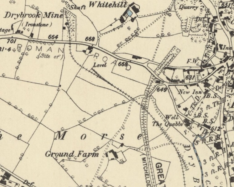
A brief mention, on the Lightmoor Press website, of ‘Trafalgar’ being used on the tramway’s northern extension, [2] encouraged a look at that section of the tramway.
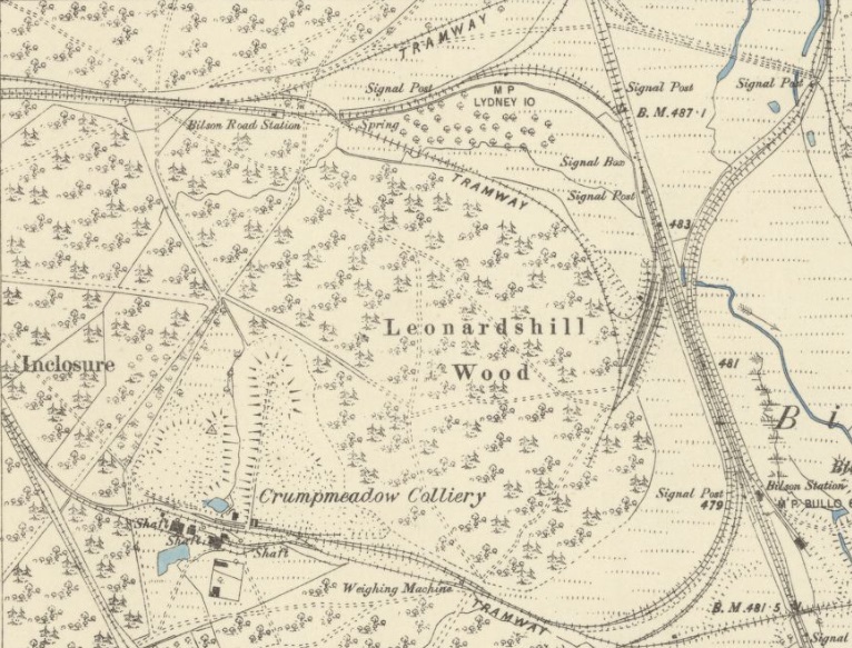
When I was writing about the Trafalgar Colliery, [6] I did not have access to the 1878/79 Ordnance Survey of the Forest which was published in 1883. That shows the transshipment sidings at Bilson junction, the Laymoor crossing and the erstwhile Bilson Road Station. It also shows the northern extension of the tramway diverging from the line to the transshipment sidings just to the North of Bilson Road Station.
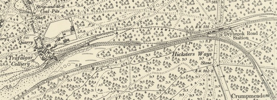
The tramway branch was built in 1869/70. It “ran north to the Golden Valley Iron Mine near Drybrook. … The earthwork remains of embankments, cuttings and the interchange embankment are visible on aerial photographs.” [8]
“The tramway earthworks divide in two at its eastern end, the northern branch heading towards Drybrook, the southern heading towards Bilson Interchange.” [8]
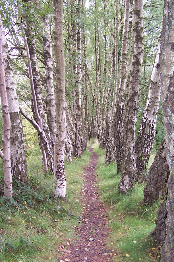
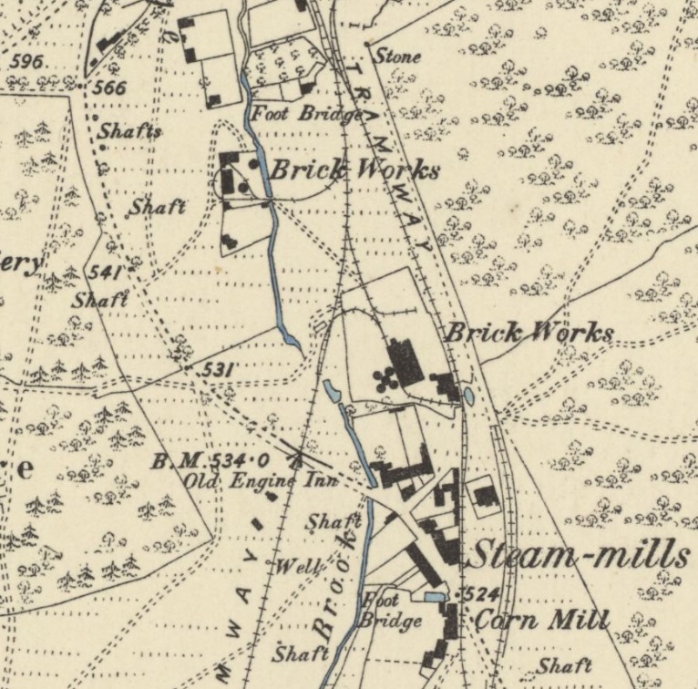
“The Brain family used clay from Trafalgar colliery at brickworks at Steam Mills.”[12][13] The tramway “ran northwards by way of Steam Mills and Nailbridge to iron-ore workings near Drybrook. In 1890 the Severn & Wye provided Trafalgar with a line to Bilson but the narrow-gauge railway continued to carry coal to Steam Mills and Nailbridge.” [13][14]
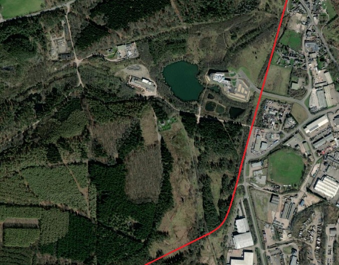
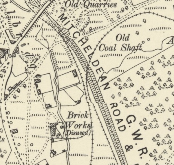
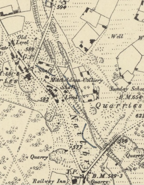
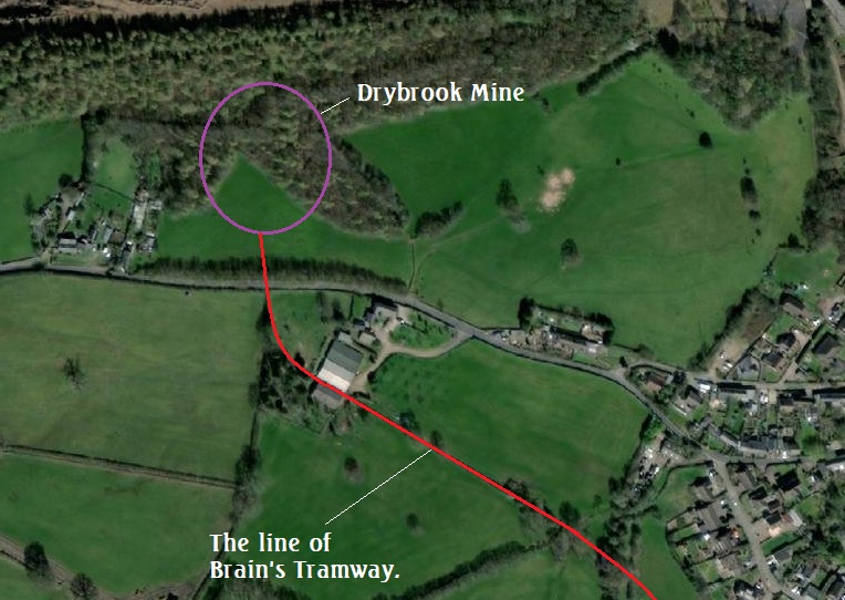
The 6″ OS Mapping published in 1883 showing the Bilson end of Brain’s Tramway and, at the very bottom of the extract, the tramway serving the Crumpmeadow Colliery. [6]The Northern Extension of Brain’s Tramway can be seen crossing the Forest of Dean Branch of the GWR/Severn & Wye & Severn Bridge Railway and then turning to head North passing to the East of Winning and New Bowson Collieries. It continues North-northeast passing off the map extract close to ‘Steam Mills’ [7]A similar area to that shown in the map extract above. a red line marks the approximate alignment of the tramway on the modern satellite image. The location of the surviving embankment is highlighted. [11]Looking Southwest along the line of the embankment which used to support the Northern extension of Brain’s Tramway. [My photograph, 15th September 2010]Brain’s Steam-mills on an enlarged extract from the 6″ 1878/79 OS Maps. The tramway connections to the industrial premises can easily be picked out. [7]This is an extract from a later edition of the 6″ OS Maps (from 1901, published in 1903). On the last map extract a complicated tramway junction appears at the top-centre. That junction had been rationalised by 1901. It is much easier to see on this plan that Brain’s Tramway continued North alongside The GWR branch-line which does not itself appear clearly on the following mapping from 1881/82. [9]Back with the 1881/82 mapping, Brain’s Tramway can be seen in a short tunnel before passing under the road at the top of the plan. [7]These two 6″ 1878/79 OS Survey plans should be taken together. They show the final length of the Tramway as it served Drybrook Iron Mine. [7]This satellite image shows the location of Brain’s Drybrook Mine. [15]
In this addendum to the articles already written about the Forest of Dean, we take a general look at the Forest through the eyes of Humphrey Household.
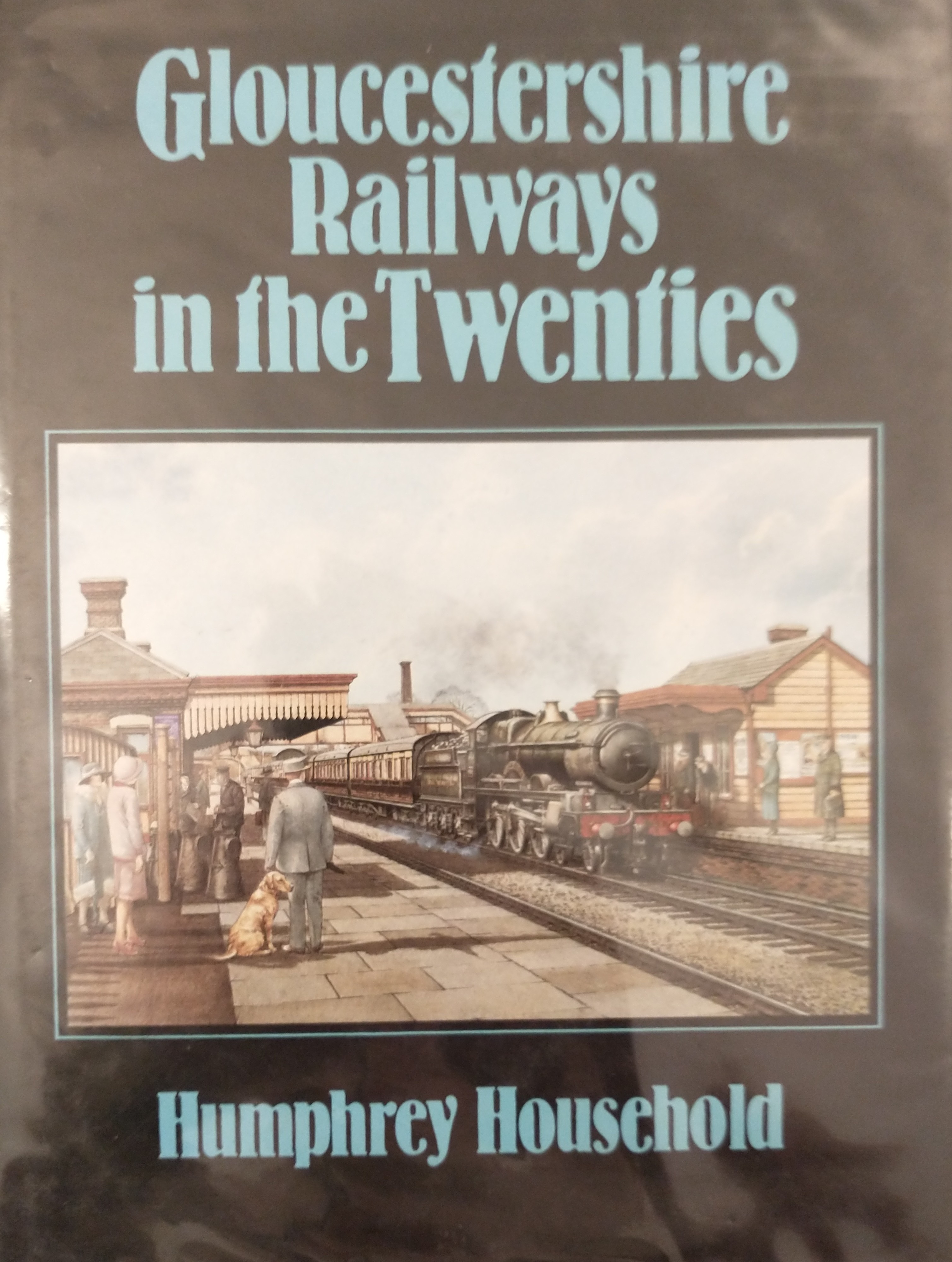
While on holiday in the Forest of Dean in September 2021, I picked up a secondhand copy of “Gloucestershire Railways in the Twenties” by Humphrey Household. [1] It consists of a review of the development of the railways in Gloucestershire supported by a series of photographs which were predominantly taken in the 1920s by Humphrey Household. The photos are a significant resource. The text of the book is well-written. Its final two chapters were of real interest to me.
The two chapters are entitled “Leckhampton Quarries” and “The Forest of Dean.” I have covered the first of these two chapters elsewhere. The second provides some interesting comments and photographs relating to the Forest.
Household had been fascinated by the Forest of Dean from an early age but did not start to photograph the Forest railways until the late 1940s. Nevertheless, his photographs from that time are illuminating. The first four photographs show the Lydney docks/canal, one, from April 1948, shows one of the coal shipping hoists on a length of the canal. He notes that the wagon turntable on the rail approach bore the date 1873. (p126) Two photographs (p125) were taken in August 1948 and show, first, the canal entrance and then the inner gates and basin with the Alma of Bristol moored. The fourth photograph is undated but shows the loading of coal and a little of the layout of tracks above the coal hoist.
Household also provides photographs of the route of the Bullo Pill Tramway. He notes that “after leaving the Riverside and passing the Bullo Cross Inn it followed a meandering course close to the contour, sometimes on a low embankment, always maintaining a gentle gradient for horses returning with empty wagons. But between Servernside and the valley of the Bideford Brook which the tramway followed from Lower Soudley through Ruspidge to Cinderford, there lay a ridge which had to be pierced. There had been plenty of canal runnels before then, but that at The Haie, 1,100 yards long, was certainly one of the earliest to be driven for a railway.” (p127). [2]
Household comments that “in 1826 a new company, the Forest of Dean Railway, was formed to take over the tramway and complete the wet dock. … The Bullo line, still remembered as the ‘dramroad’, was remarkably simple in operation. The wagons, carrying a ton or two at a time, proceeded at no ‘faster rate than a Horse could walk’, and when two met, the loaded one had right of way, the other perforce returning to the nearest turnout. Through the tunnel, wherein none might ‘carry or use a lighted torch’, the wagons passed in groups, the driver of the rearmost distinguishing it with the branch of a tree and blowing a horn when he emerged at the further end.” (p127-130)
The operation was straightforward. The new tramway company halved the tolls charged for coal and completed the wet dock, enlarging the wharves at the same time. The use of steam locomotives was considered but rejected because of the alignment of the route and the size of the bore of Hair Hill Tunnel. However the arrival of the broad gauge running from Gloucester to Chepstow in 1851 changed things. The Forest of Dean Railway sold out to the South Wales company and Brunel decided to convert the tramway so as to be able to accept steam locomotives. A series of six photographs taken by Household in April 1952 show different part of the alignment of the Bullo Pill Tramway.
Household also mentions an abortive attempt to construct a third tramway midway between the other two. The intended route ran between Purton Pill and Foxes Bridge (on the Littledean-Coleford road – the B4266). He says that “the prospectus bore the grandiose title of the Purton ‘Steam Carriage Road’. [3] Construction began, and at Viney Hill above Blakeney part of the formation can be seen leading in s south-easterly direction from beside the A48 Lydney road, and nearer Purton there is a completed arch intended to carry the railway over the Blakeney-Purton road.” (p130) Household provides two further photographs (p134) to illustrate the two locations that he mentions. Grace’s Guide provides a photograph of the three-span arched viaduct to which, I think, Household refers. It remains today sitting over the road between Purton and Etloe. [4]
References
Humphrey Household; Gloucestershire Railways in the Twenties; Alan Sutton Publishing Ltd., Gloucester, 1984 (reprinted 1986) …. the relevant chapter can be found from p124 onwards.
In early September 2020, while staying in Bream in the Forest of Dean we walked around the Titanic Steel Works and the Dark Hill Ironworks of father and son David and Robert Mushet. These two establishments sit adjacent to what was the Coleford branch of the Severn and Wye Joint Railway. They were also served, in its time, by the Milkwall branch of Severn and Wye Tramway.
The location is significant in the development of the Bessemer Process for making hardened steel. Robert Mushet took the relatively novel ideas of Bessemer and refined them to the point where the process became functional in an industrial context. [3]
The tramway closed when the Coleford Branch opened as the route of the new railway closely followed the old tramway. There are only a few places where the route of the old tramway diverged from the newer railway and one of these locations is in the area of the Mushet owned works. The next few OS Map extracts come from the very early series of 25″ OS Maps which were drawn in the period from 1873-1888, nonetheless, the old tramway was by this time only a memory,
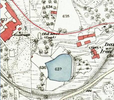
At the Eastern end of the Dark Hill Iron Works site, the old tramway diverged from the line of the Severn and Wye Joint railway. The loop shown here was no doubt provided to lessen the gradient. Steam power enabled the newer railway to take a more direct route. The Severn and Wye Joint Railway is shown by the double black lines which curve from the right of the map extract to pass through the words ‘Darkhill Iron Works’ at the bottom of the extract. [1]
The tramway route shown by the thin red line ran across the North side of Darkhill Iron Works and then on the Northeast side of the Titanic Steel Works. The Severn and Wye Joint Railway looped round the South side of the two sites. [1]
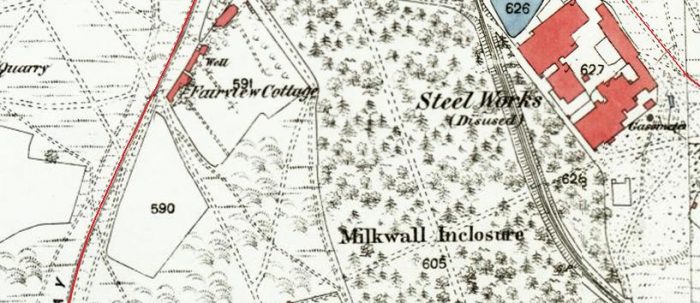
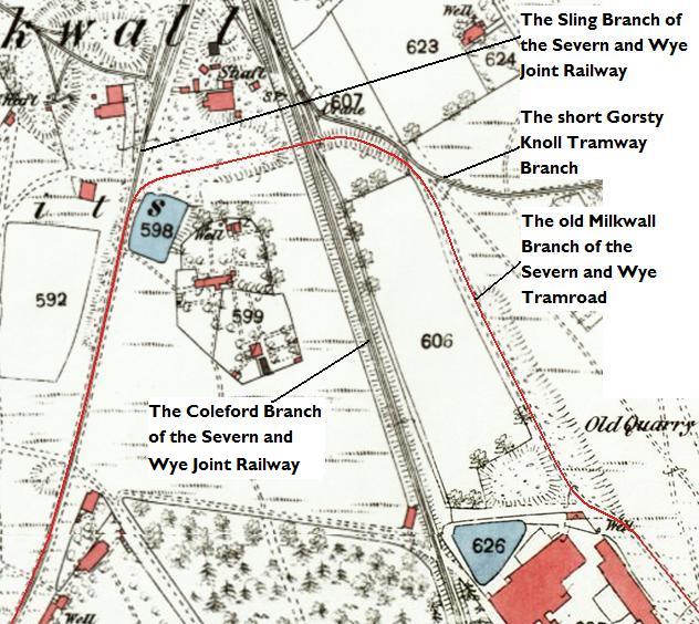
The two distinct red lines which appear on this map extract are both part of the old Milkwall branch of the Severn and Wye Tramroad. That to the West of the Map extract became the Sling Branch which left the Coleford Branch of the Severn and Wye Joint Railway at the small Milkwall Station to the North. That railway can be seen running to the West side of the Titanic Steel Works. The other red line is just to the Northeast of the Titanic Steel Works. [1]The two arms of the tramway which are seen as red lines on the map extract prior to this one are shown coming together just to the South of the Milkwall Station on the Severn and Wye Joint Railway which is sited just off the North side of this map extract.
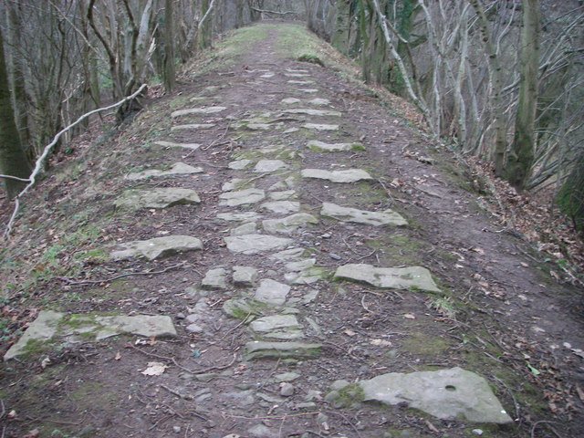
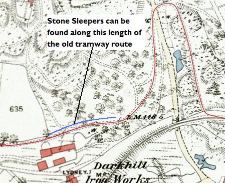
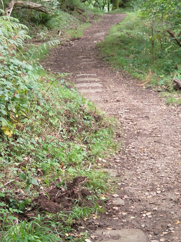
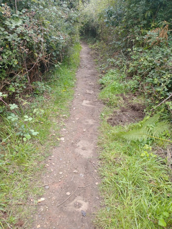
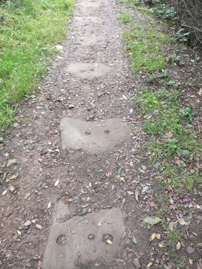
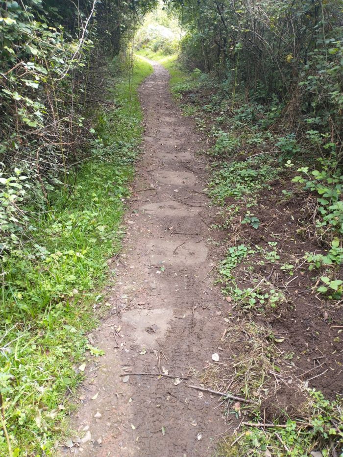
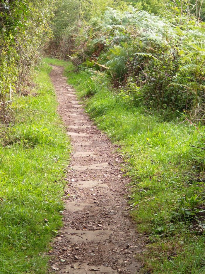
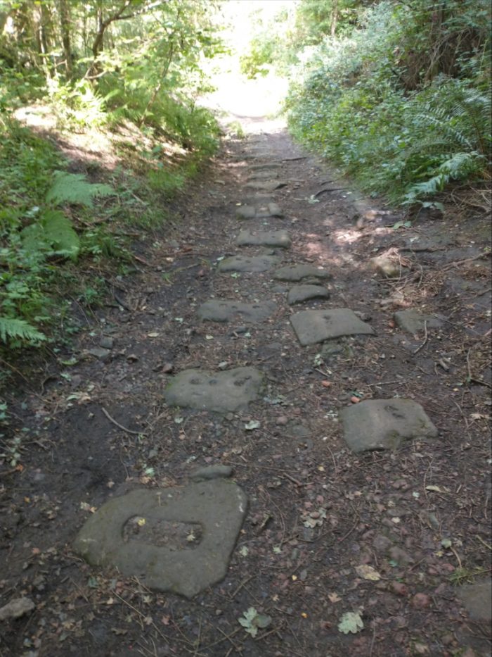
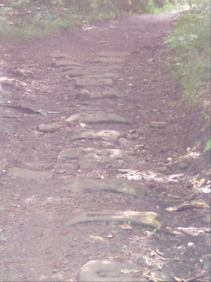
We followed a Heritage Walk route which took us around Milkwall and Dark Hill areas of the Forest. [2] We encountered a significant section of the old stone sleepers which were used to support the cast-iron L-shaped plates which the trams ran on. Pictures I took at that location follow. I have also included a photograph taken the same week at the Dean Forest Railway which shows how the plates were keyed-in to the stone sleepers using purpose made ‘chairs’.
Generally the modern footpaths which follow the routes of these old tramways are not wide enough to allow both rows of stone sleepers to be seen.
The different gauges used at different times in the Forest can be seen clearly in this picture taken at the Dean Forest Railway at Norchard on 2nd September 2020. The tramway gauge and construction can be seen in the foreground. Tramways in the forest were of 3’6″ to 3’8″ track gauge. Each plate was fixed in place by a metal chair which in turn was supported by an independent stone block/sleeper. All the photographs above are my own.
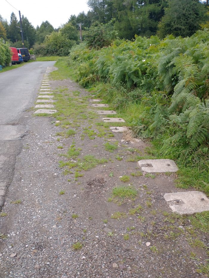
As we noted when looking at the map extracts above, the Sling branch of the Severn and Wye Joint Railway followed the line of the older Milkwall Tramway. Our walk took us, for a short distance, along the line of the Sling Branch. The more modern rails of the branch were supported on concrete blocks similar in size to the stone blocks which once supported the tramway. My picture below shows these concrete blocks where they are still visible outside Fairview Cottage which appears in the third of the four map extracts above.
There is an app which can be downloaded to mobile phones which provides access to a number of different Walks, one of these is the Coleford Heritage Walk, part of which we followed: https://www.forestersforest.uk/projects/12/hidden-heritage-app, accessed on 3rd September 2020.
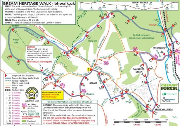
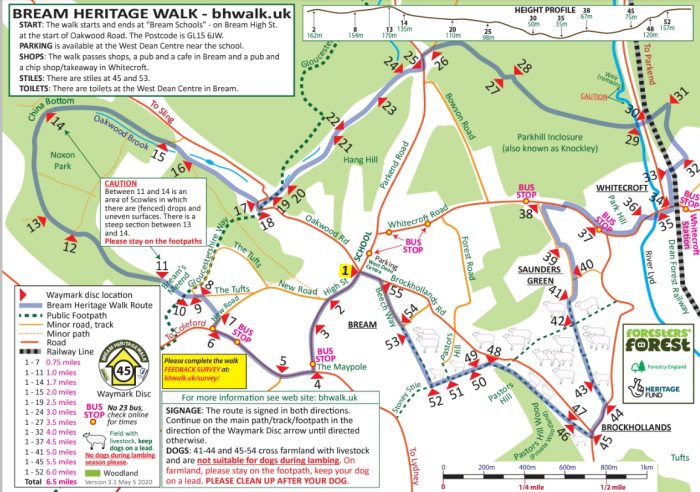
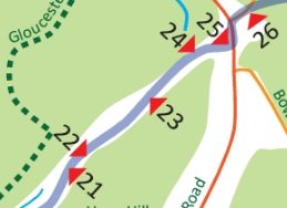
We are in the Forest of Dean again for a week away from work. On 1st September 2020 we followed a sign-posted circular walk which started in the centre of the village of Bream on the Southwest side of the Forest. The route was planned with the support of the Big Lottery Heritage Fund and featured a series of different heritage locations around the village. An overview plan appears below. [1]
Bream was one of a number of villages which sat on the edges of the old Royal Forest of Dean and in pre-industrial times had a population of around 300. The industrialisation of the Forest brought relatively rapid expansion to many of these villages. Bream’s population in the early 21st century is over 3,000.
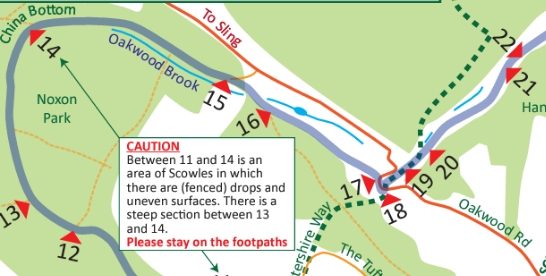
The walk, including the different detours that we chose to make was about 7.5 miles in length. The first sections of the walk were along modern roads but we soon found ourselves walking along one of the access routes that would have been used by the workers in the iron ore mines in and around Noxon Park.
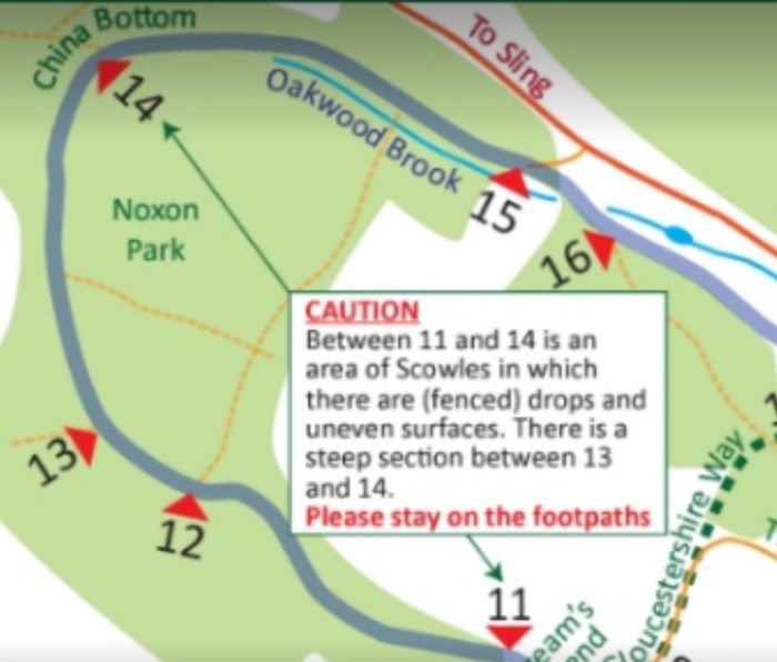
We passed a number of caves and sink-holes which were created by early iron ore miners. The area is riddled with underground workings and a number of relatively large caves have, over the years collapsed to create large and deep depressions (or scowles) at the surface. These can be found between locations 11 and 14 on the walk route map.
Initially, these workings were served by packhorses that carried the iron-ore away to be refined, but by the 19th century, plateways or tramways were being built to improve the transport of the ore.
The walk took us first along the route of the China Bottom Branch of the Oakwood Tramway which was covered in an earlier post about the tramways in the Forest (https://rogerfarnworth.com/2017/10/02/oakwood-and-dikes-tramways). [2] The branch ran between the approximate locations 13 and 14 on the map above. The track shows up on the old map below as two dotted lines leading from the bottom left of the map towards China Bottom.
When we reached China Bottom, we joined the route of the Oakwood Tramway which can be seen running left to right across the map extract below. The early China Bottom Branch served the small mines in the Noxon Park. These were superseded by the larger mines at China Bottom and Princess Louise and the early tramway branch was then abandoned and the cast-iron rails were lifted.
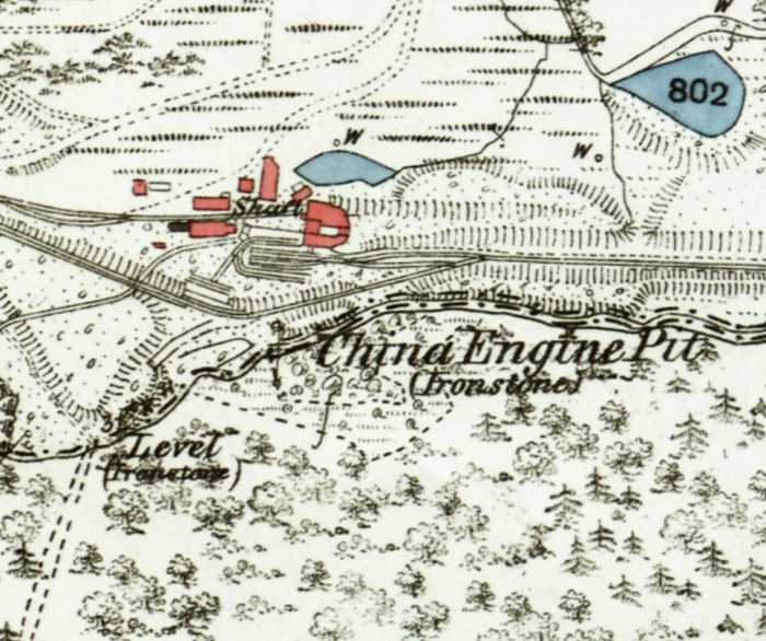
Extract from the OS 25″ Map on the mid 19th Century. [5]
China Bottom takes its name from a large iron-ore mine which once occupied the site which was called ‘China Engine Pit’. Its name indicates that the mine had a powerful steam engine which lifted iron-ore to the surface and pumped out water from the mine. “These engines were usually beam engines of the type used in Cornish tin mines, as seen on the TV series Poldark.” [7]
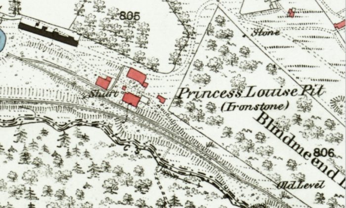
Close by was another large iron-ore mine called the ‘Princess Louise’ which had a 180 metre deep shaft. For more information, see the ‘Derelict Places’ Website. [3]
Princess Louise Pit, OS 25″ Map from the mid 19th century. [6]
The Oakwood Tramway
From location 14 through to between location 20 and 21 our path followed the route of the Oakwood Tramway. We picked it up again by taking a diversion northwards from location 24.
Oakwood Tramway ran, at first, on the Northern side of Oakwood Brook, between locations 14 & 15. The brook was culverted under the tramway and then supplied water power for Oakwood Mill which sat close to the brook between it and the road between Sling and Bream. [1]
At location 16 on the walk we passed Oakwood Mill Land Level, another iron ore mine.
“The land level was driven from 365 feet O.D. at the entrance. It is an adit or tunnel driven into the hill side for a distance of 1650 feet (500 metres). From the far end of the tunnel further levels were driven at right angles to facilitate mining and removal of the iron ore. The level also allowed water to drain from the iron ore measures above 365 feet, allowing previously underwater deposits to be exploited. The level can be seen on Sopwith’s Map of 1835“. [11]
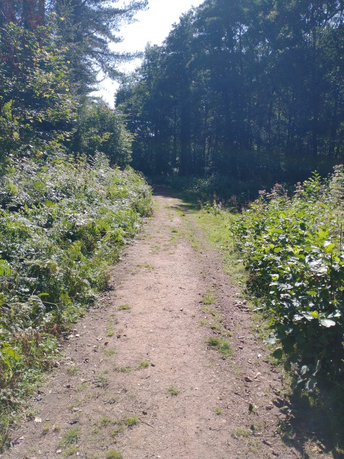
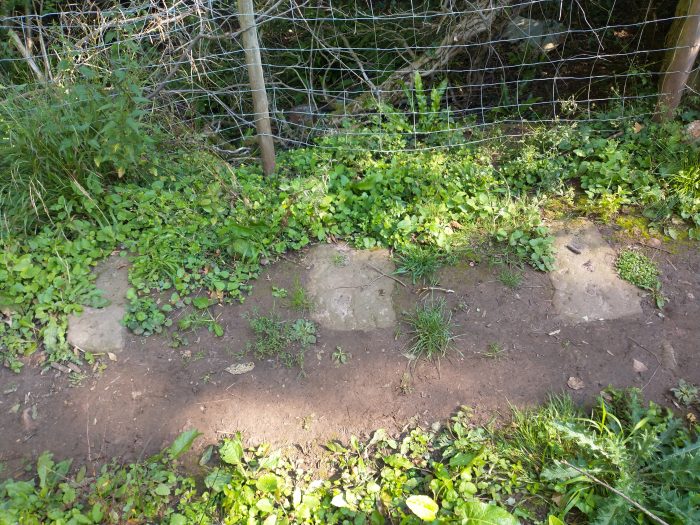
In 1827 David Mushet the metallurgist laid the earliest length of the Oakwood Tramroad from this area to Parkend. “Within a short distance you can observe a series of large flat stones in the pathway. These are sleepers for the Oakwood Tramway which terminated at Parkend and was used to transport mainly iron ore for transfer to the railway at Marsh Sidings (near Parkend’s Fountain Inn).” [11]
To the left and right of the walk route we came across dry mill ponds which originally “fed the water wheel at the Oakwood Corn Mill. The mill occupied the old buildings to the left and the waterwheel which drove the machinery was situated in a sunken chamber at the side. The sluice gate, which released the water onto the wheel, can be seen in the far corner of the stone-lined pond. It is probable that the operation of the mill was sporadic and dependant on the mill ponds containing sufficient water to drive the wheel.” [11]
The route of the Oakwood Tramway between locations 14 and 15, 1st September 2020.The different gauges used at different times can be seen clearly in this pisture taken at the Dean Forest Railway at Norchard on 2nd September 2020. The tramway gauge and construction can be seen in the foreground. Tramways in the forest were of 3’6″ to 3’8″ track gauge.
The Oakwood Tramway most probably consisted of L-shaped cast-iron rails resting on stone blocks or sleepers, as shown above, which served to spread the load over the ground, and to maintain the gauge. We located a number of these stone blocks along the first length of the tramway between 14 and 20. Each had two or three holes into which the rails or ‘plates’ were fixed. A few photographs taken on 1st September 2020 at different locations along the path, follow. …
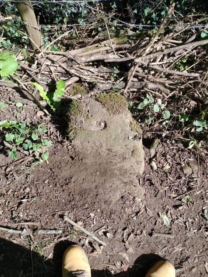
There were long lengths of the route where usage and time have resulted in these stone blocks/sleepers being covered. “From this point, the tramroad did not plunge down the slope to the bottom of Mill Hill, it ……. went to the right and took a level path that hugged the hillside as it continued along the valley.” [12] It then turned to the Northeast following the valley.
In the valley bottom is what, in the 21st century, is a large white rendered private house. This was, until 1969, the ‘Oakwood Inn’.
At location 19 on the walk we passed what was once Oakwood Mill Deep Level iron-ore mine. It was driven in the early 1800’s by “David Mushet and it drained water from the earlier surface workings, both draining the mine of water and allowing a much easier extraction of ore.” [13] And at location 20, we passed the remains of Bromley Furnace.
The next significant location on the walk is the Oakwood Chemical Works and Flour Mill Colliery. We will return to look at the route of the tramway after we have looked at the Flour Mill Colliery site.
Flour Mill Colliery and its present use.
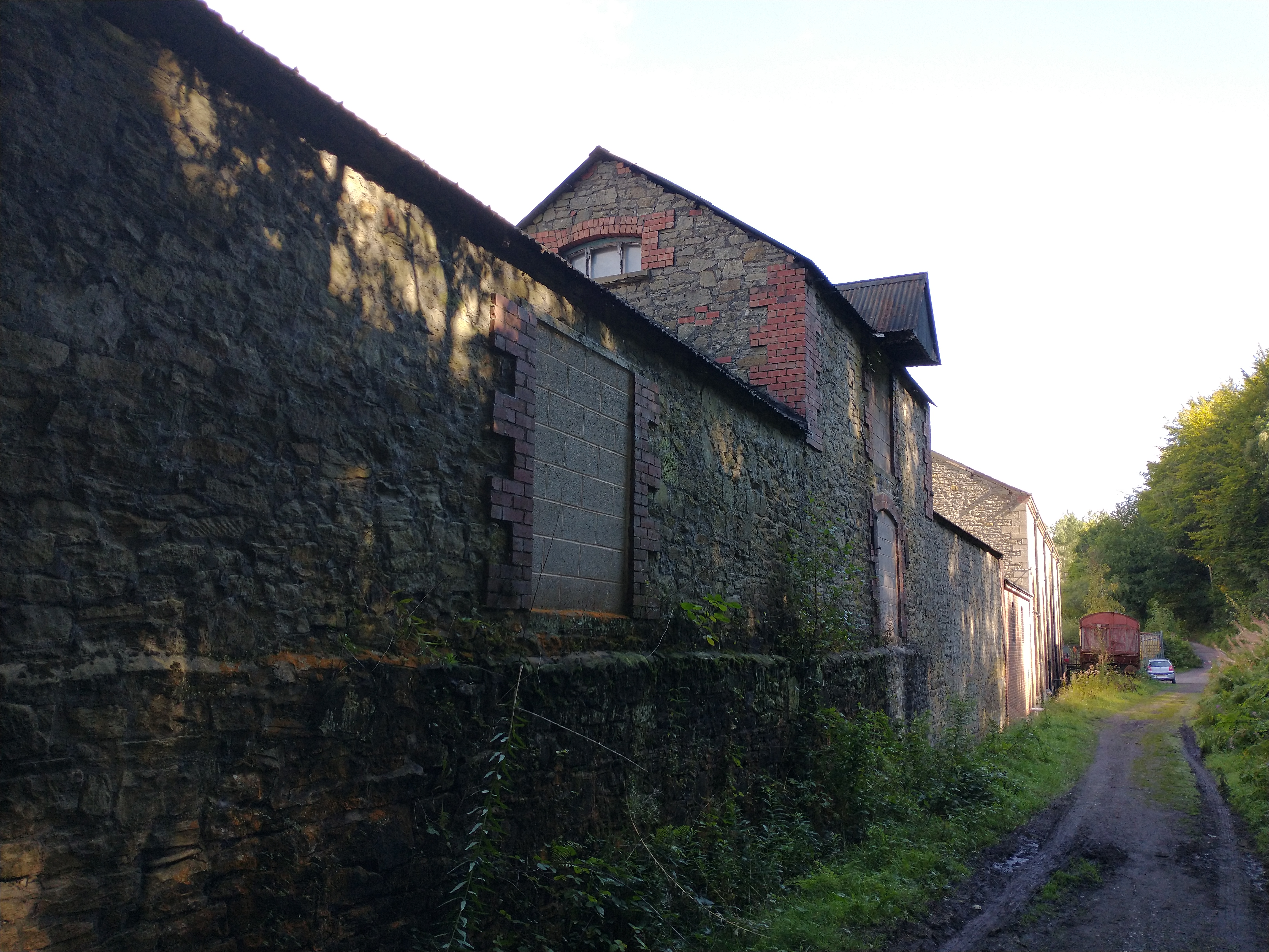
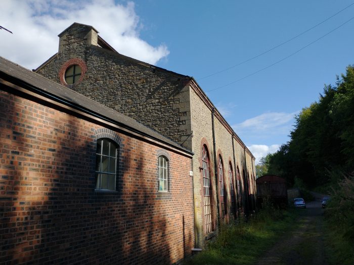
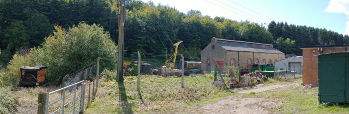
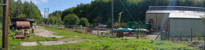
At locations 21, 22 and 23 on the walk we passed the site of Flour Mill Colliery. The walk runs immediately alongside the remaining colliery buildings on the line of the old tramway.
A while ago, the Colliery and the current use of its remaing buildings featured on my blog. [4]
The buildings of Flour Mill Colliery sit immediately alongside the route of the Heritage Walk, 1st September 2020.The Electricity Generating Hall/Building of the old colliery is now in use as an engineering works, 1st September 2020.
These buildings are now in use for the repair and refurbishment of steam locomotives. We spent a while wandering around the boundary of the works.
For more pictures please click here, [9] and for more information about the engineering works please click here. [10]
The route of the walk deviates away from the tramway alignment approximately at the entrance to the modern works, just northeast of the electricity generating hall. The tramway route begins to drop away heading for the transshipment wharves at Parkend.
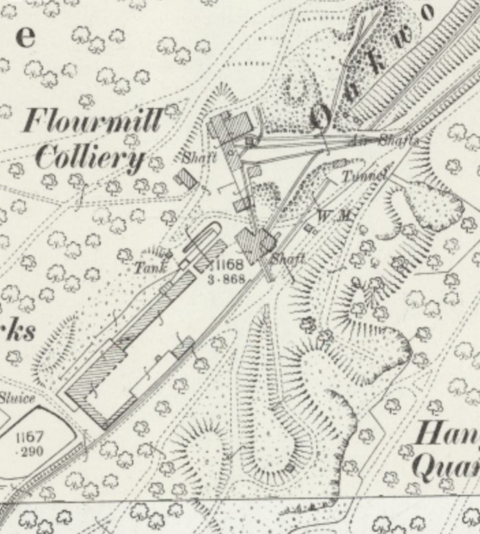
When Flour Mill Colliery was expanding in the late 19th century it had to bridge the Oakwood Tramway which ran through the enlarged site. The later 25″ OS Map extract below shows the site of Flour Mill Colliery towards the end of the 19th century. The Oakwood tramway can be seen bridged by a relative wide man-made land bridge. [15] This is approximately at location 23 on the walk. The Oakwood Tramway leaves the map extract in the top right corner heading for Parkend. A rope-worked incline runs away to the right just to the South of the Oakwood Tramway. That incline led to what was most recently known as the Princess Royal Colliery. ……
The 25″ OS Mapping of the late 19th century shows that Flour Mill Colliery had two shafts. The more southerly of the two had required a bridge between the shaft and the colliery spoil heaps. The more northerly of the two shafts, later required a land bridge over the tramway which was first culverted before the land was built up to provide access across the Oakwood tramway to a rope worked incline which took coal from Flour Mill Colliery to Princess Royal Colliery. [8][14]
The Oakwood Tramway again
25″ OS Map extract [18]
To the Northeast of the land bridge, Oakwood Tramway was in deep cutting. Its route could only be found by taking a deviation from the Bream Heritage Walk at location 24 on the walk route shown above. It was a delight to find significant remains of the tramway between this point and the Parkend Road.
The Oakwood Tramway was a single-track line with passing places. The two pictures immediately below were taken to the North of location 24 on the Bream Heritage Walk. They show the location of one of these passing places. A shirt loop of line left the main route and returned back to join it in a very short distance. Just long enough to accommodate a train of trams and their motive power (a horse or two)! The map extract below shows the location. [16]
The two pictures show the northern end of the passing loop which can be seen on the OS Map above. The first looks north, the second looks South. Both pictures were taken on 1st September 2020.The rope-worked incline passed under the Bream to Parkend Road at this location. The barrier protect the drop into the cutting, (Google Streetview).
Our walk turned away from the Tramway just North of the location of the passing loop shown in the pictures above. We walked up to the Parkend Road and turned back towards Bream. We were able to make out the point where the rope-worked incline passed under the road. The last picture above was taken from the Bream to Parkend Road at location 25 on the Bream Heritage Walk,
We were staying in the Forest of Dean in September 2020 and followed the Bream Heritage Walk. Details of the walk can be found on my blog, [1] and independently on-line here. [2]
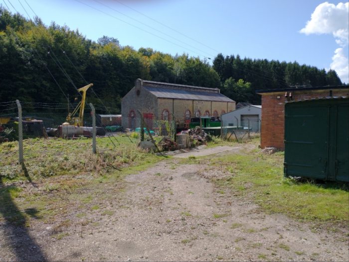
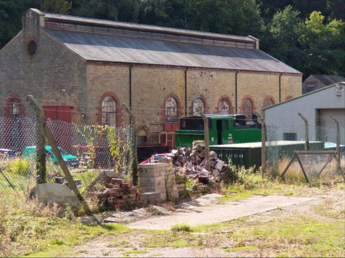
The walk passes alongside the engineering works at Flour Mill Colliery. [3] We spent a while walking round the industrial site before continuing our walk.
“The Flour Mill is a listed building which was converted to a railway workshop in 1995 – 1996, and used as such since 1996. The Flour Mill Ltd operates the business in the building undertaking work repairing and overhauling steam locomotives.” [3] Please note that this is a working site and not a visitor attraction.
It was possible, from outside the boundaries of the site, to take a number of photographs which might be of interest. …..
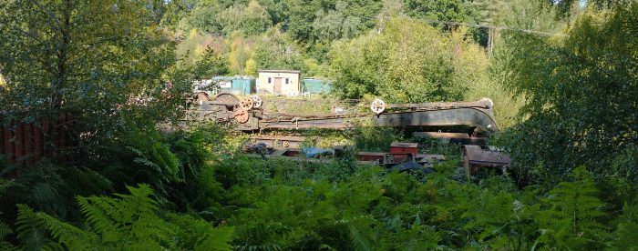
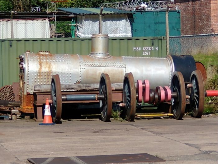
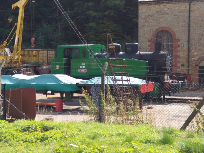
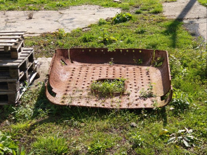
Locomotive boiler and driving wheels/axles. Others may be able to give an idea of the provenance, 1st September 2020.
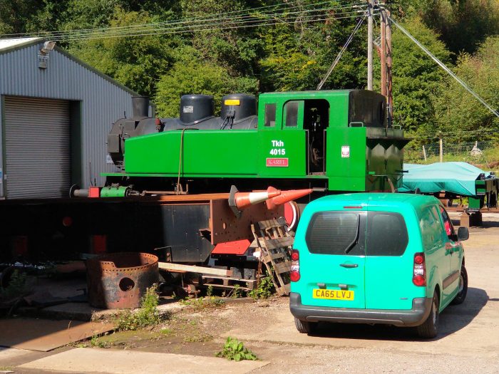
These two photographs show Locomotive TDK 4015 ‘Karel’ outside the main works building. This locomotive was imported to UK and moved to the Avon Valley Railway. It was withdrawn in 2013, and sent to the Flour Mill in the Forest of Dean for overhaul. It returned to traffic September 2016 but was back under repair again in 2020. It was made by Fablok, Poland in 1947. [4][5] (1st September 2020).
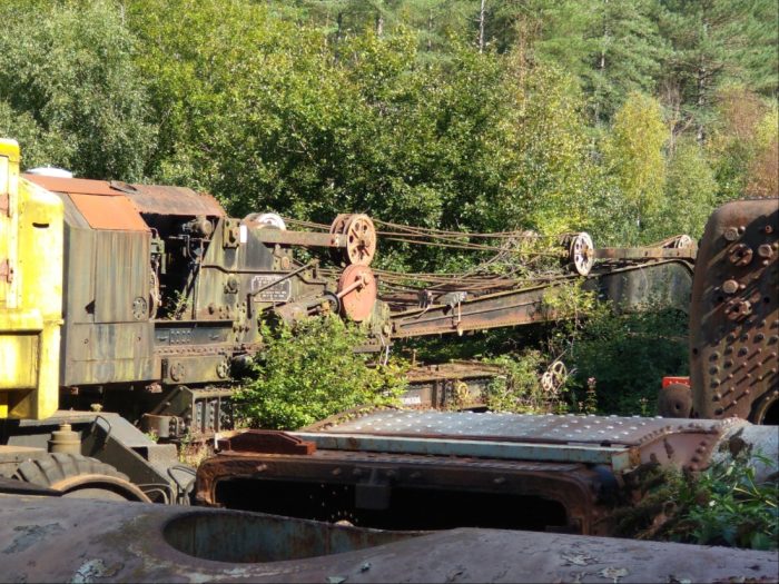
Another locomotive boiler and the site crane, 1st September 2020.
These two images show a railway crane awaiting refurbishment. I will have to rely on others to provide more information! (1st September 2020).
The next series of images are all taken from the North boundary of the site.
More information about the site can be found on The Flour Mill’s website. [3]
In the Autumn of 2019 we spent a week in the Forest of Dean. I came across two books about the Forest which are both quite small. Both are facsimile copies of much older works.
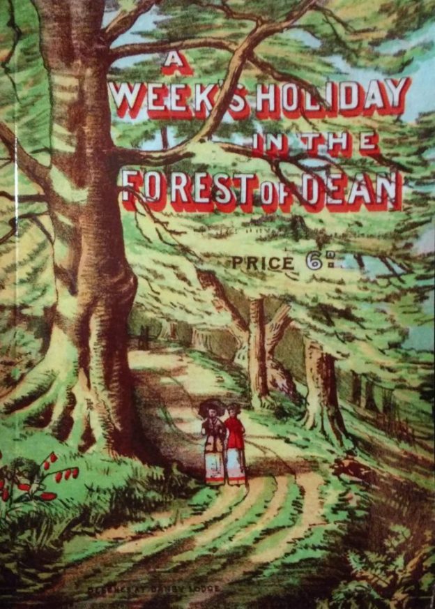
A Week’s Holiday in the Forest of Dean
The first appears in the featured image above. It is a copy of a book written by John Bellows, a well-known publisher based in Gloucester. “A Week’s Holiday in the Forest of Dean” was first published in the 1880s and facsimile copy was prepared and published in 2013 by Holborn House Publishing. [1] A preface has been added, written by Ian Standing, it gives some biographical details about John Bellows and covers the publication history of the book.
Bellows chose to travel from the Midland Station in Gloucester to Berkeley Road and then through Sharpness along the Severn and Wye Joint Railway. His journey took him across the Severn Railway Bridge and on through Lydney into the Forest.
He describes the station at Speech House Road and the walk up to Speech House from the Station.
Then, the following morning, Bellow’s party travelled down the hill from Speech House to Cannop Brook. Crossing the bridge, they spent a short while viewing the chemical works which were at that location before pungent odours chased them away. Their route, for a short way, was then along an old tramway. [1:p25] Might this tramway have been the Bixlade Tramway or part of the route of the Severn and Wye Tramway which was the fore-runner of the later standard-gauge railway?
Perhaps the more likely tramway is that which ran up Wimberry Slade, the route of which ran through what became Cannop Colliery and in much more recent times a Highway Depot for the Forest and a Cycle Hire Centre.
There are references throughout the text to the railways in the Forest. … In Bellows journeys around the Forest, trains were used, as were the railway lines which carried them. Bellows casually remarks that the route to Trafalgar Pit from Speech house involved his party walking, “straight across the open turf and down the path across the Beechen Hurst, til [they] strike the Railway in the Valley, mount the embankment, and walk along it to the right as far as the signal-box, where we leave it for a forest path on the left, running parallel to the line, which brings us to the huge ‘dirt-heap’, on which the rubbish of the pit is shot.” [1:p59]
Bellows party goes on to visit St. Briavels. He comments: “The train from Speech House Road would deposit us at Millwall Station, with no fewer than nine important iron ore mines within the circuit of a mile.” [1:p61]
This little facsimile book is a pleasure to read and a excellent way if getting a feel for what the Forest of Dean was like in the late 19th century.
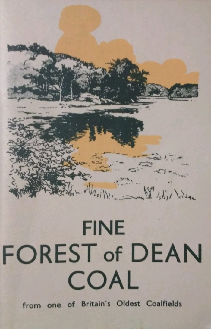
Fine Forest of Dean Coal
The second little book was originally published by the Forest of Dean Colliery Owners’ Association, Cinderford. It carries a lot of contemporary advertising and is itself a publicity booklet for the coal mining industry in the Forest of Dean. It has been reproduced in the Lightmoor Facsimile Series and is No. 2 in that series.
The booklet contains a short history of mining in the Forest, clarifies the status of Free Miners, explains the arrangement of the different coal measures underground.
The Fuel research board had just completed a survey of the coalfield focussing on the Coleford Highdelf Seam which was worked by the remaining large collieries. The moisture content of the coal prior to extraction and treatment was 3.4%. Once air-dried, the moisture content reduced to 2.8%. The volatile matter in the coal amounted to close to 40%.
All of the collieries in operation in the forest were fitted with modern screening arrangements and picking belts. Cannop had recently had a Dry-Cleaning Plant installed for small coal below 2″.
The booklet focusses on each of the collieries in the Forest in turn: Cannop, Lightmoor, Eastern United, Northern United, Lydney & Crump Meadow, Parkend Deep Navigation (New Fancy), Princess Royal, Park Collieries. Each has at least one photograph.
References
1. Ian Standing and David Harris; A Week’s Holiday in the Forest of Dean; facsimile copy of a publication with the same title written by John Bellows; Holborn House, 2013.
2. J. Burrow, Ed.; Fine Forest of Dean Coal; Forest of Dean Colliery Owners’ Association, Cinderford; facsimile published by Lightmoor in the series … Lightmoor Facsimile Series, No. 2.


