
This is a first look at the Ketley area just a few miles from where we live in Malinslee.
This was a short walk which encompassed a variety of industrial remains. The route taken is shown by the red line on the image below which comes from the Ketley Paddock Mound website. ……
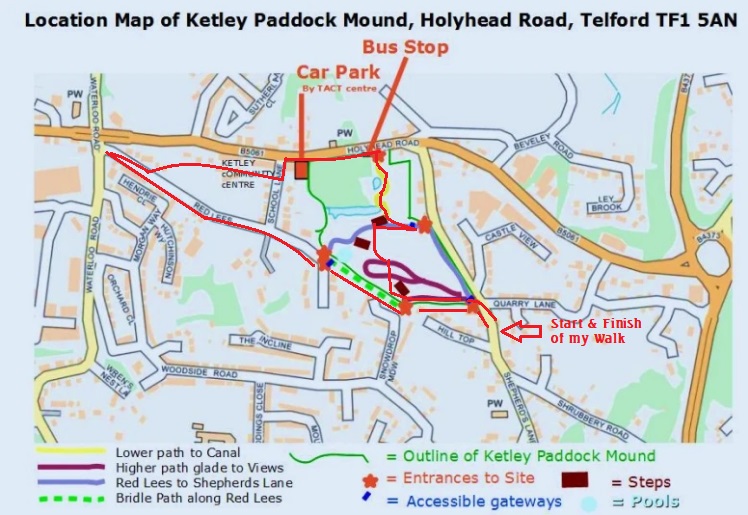
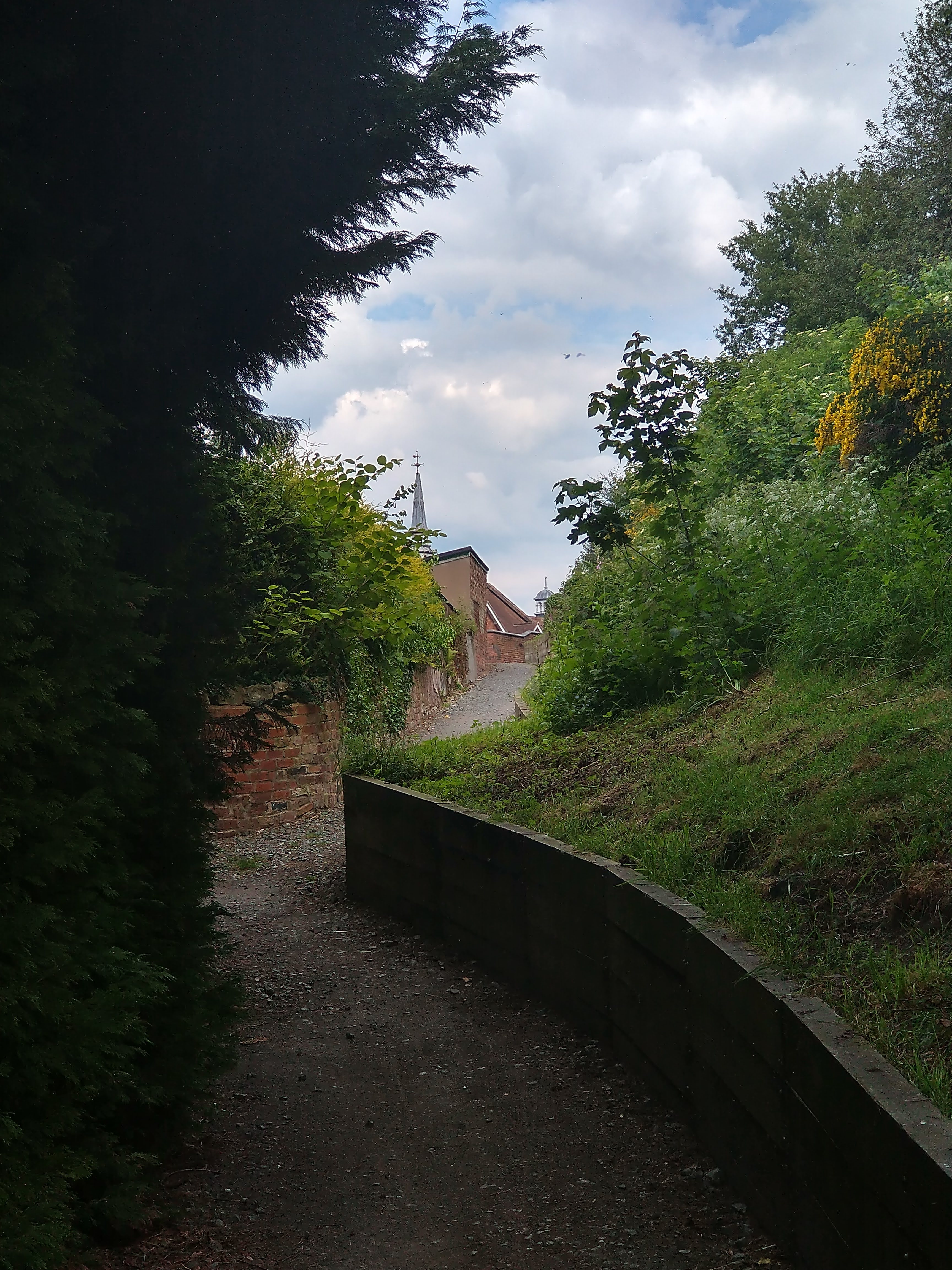
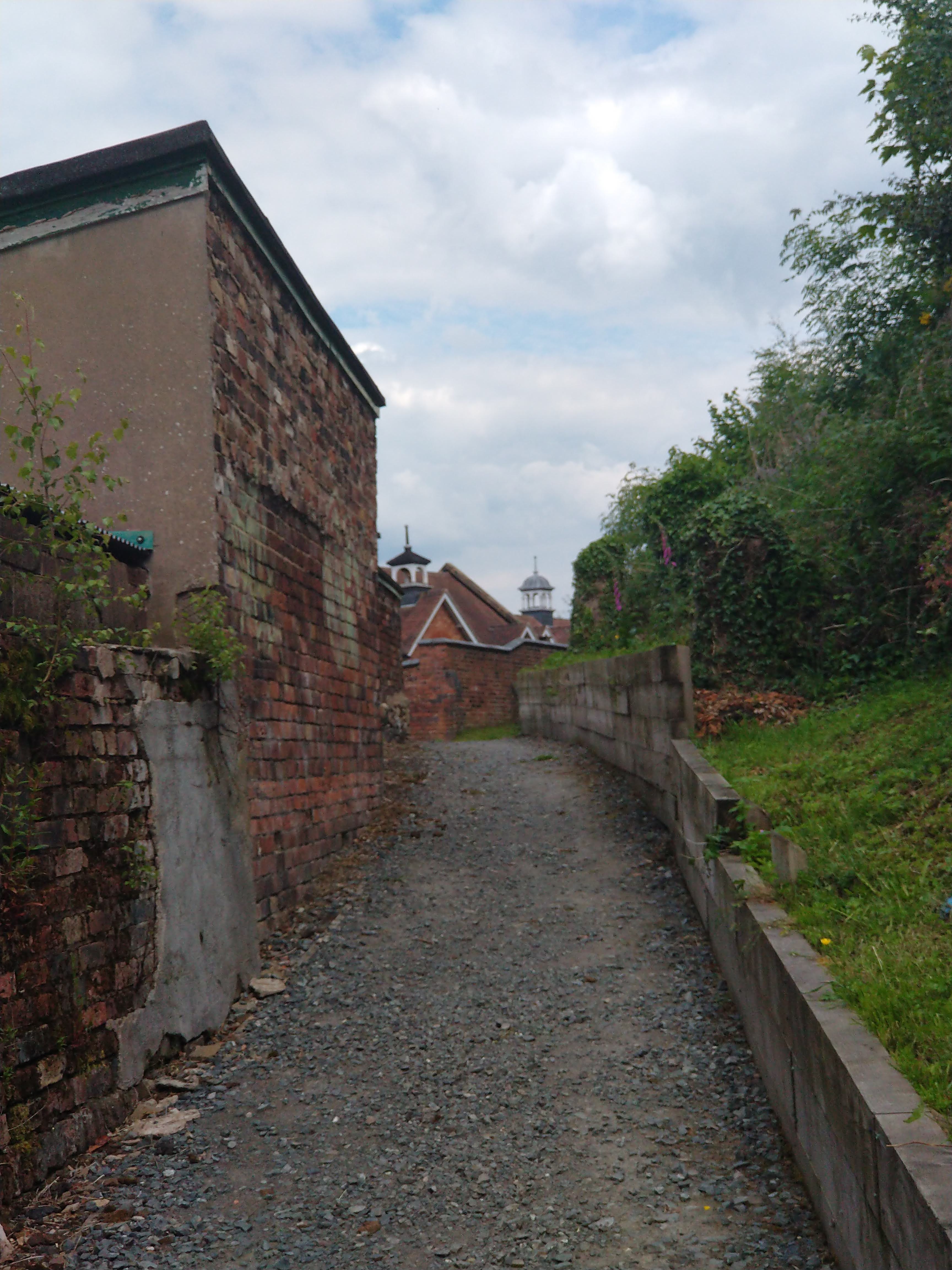
I parked close to the church of St. Mary the Virgin in Red Lake and walked North up Shepherd’s Lane, turning left into Hill Top. Hill Top becomes Red Lees. The route of Red Lees was crossed by a high-level tramway which probably linked a colliery to what is now called Ketley Paddock Mound and was a colliery slag heap. the extract from the 1882 25″ OS Map below shows the location.
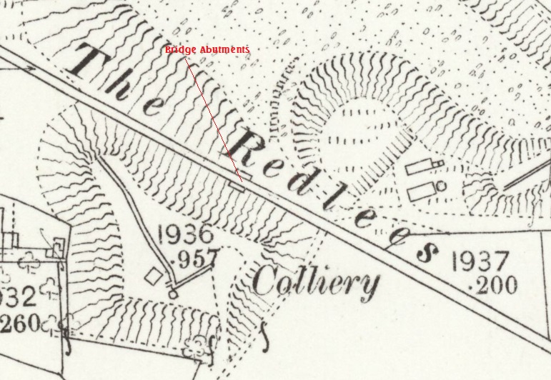
It seems to me to be unlikely that the tramway which used this bridge was directly associated with a larger network of tramways in the area. The map extract shows other short sections of tramway immediately at the colliery location and is seems highly likely that there was a need to cross Red Lees at high-level to reach the large slag heap to the North of the lane.


Recently, reading ‘A Ketley Mon’ by Terry Low, I came across an older photograph at this location. It was taken in 1906 and shows the pier probably at its fullest height. It seems as though it was originally built in masonry and, at a later date, extended upwards in brick. Whilst it is impossible to be sure what this means, it suggests that there was a need at some stage to lift the line of the tramway. An obvious explanation for this would be the growth of the slag heap which is to the right of the picture below.

Walking Northwest from the location of the tramway bridge, it was apparent that this section of Red Lees followed a straight course. Possible explanations for this include:
- the development of the colliery and the slag heap required an established right of way to be redrawn to accommodate the work. I cannot find maps early enough to look at what predated the industry at this location; or
- Red Lees itself, may have been part of the route of a tramway.
It would be interesting to be able to test these ‘theories’, if earlier detailed maps were available.

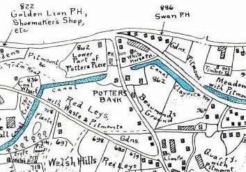
We know from early maps that the Ketley Canal once crossed Red Lees to the East of Ketley Hall.


I followed Red Lees down to the junction with the B5061, before walking back along Red Lees following what probably was a tramway route which then drifted away from Red Lees to the Northeast as shown on tthe sketch map at the head of this article. The Ketley History website says the following: “Behind the Victorian school building that is now Ketley Community Centre, there is a footpath that leads down to Red Lees and this is also the line of a tramway, probably to serve the coal wharf that was situated on Ketley Canal where School Lane meets Red Lees now.” [5]


I turned to the left and walked along School Lane to the B5061, which, incidentally was the A5 and so was Thomas Telford’s trunk road to North Wales, and so it carries the name ‘Holyhead Road’.
The Ketley Canal
The Ketley Canal was about 1.5 miles (2.4km) long. It linked the Shropshire Canal, in the small town of Oakengates, with Ketley Iron Works. It was built in the late 18th century (around 1788) and required the construction of an inclined plane to lower and raise tub-boats a little over 70ft between the level of the Works and the higher ground that it travelled over from Oakengates. [8]
The inclined plane was the first effective inclined plane in the UK. [9]
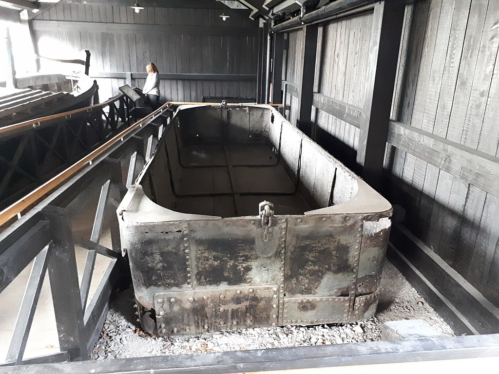
The canal predominantly carried coal and ironstone in horse-drawn tub-boats. These tub-boats where in use across Shropshire and beyond. They “were rectangular in plan, 19 feet 9 inches long x 6 feet 2 inches wide made of wrought-iron plates rivetted together. An inclined plane consisted of two rails laid parallel to each other, on each of which ran a cradle raised or lowered by a wire rope and capable of carrying one tub boat at a time. The descending cradle assisted in balancing the weight of the ascending one and the extra power required was supplied by a stationary winding engine. A boat descending an inclined plane entered a chamber where it was manoeuvred over a submerged cradle. Once in place, the boat was secured to the cradle in readiness for its journey down the plane. The cradle was then hauled up over a sill and onto the plane, at which point it was still inside the chamber. When everything was ready it commenced its descent, which required just a few minutes, and a small number of workmen were able to complete the whole operation.” [12]
The inclined plane lasted in service until 1816, closing with Ketley Iron Works. The length of canal between Ketley and Oakengates remained open for more than 60 more years until the 1880s.
“One tub-boat is preserved in the Blists Hill Victorian Town museum. It was rescued from a farm in 1972, where it was in use as a water tank. Before its discovery, it was thought that all tub boats on the Shropshire Canal were made of wood.” [13]
The canal ran on the north side of Holyhead Road. A few hundred yards to the West of Shepherd’s Lane the canal passed under the Holyhead Road. It “clung to the southern side of the main road for a few hundred yards … but then it moved away from the road, heading westward at the backs of what are now gardens on Holyhead Road until it reached Shepherd’s Lane.” [9]

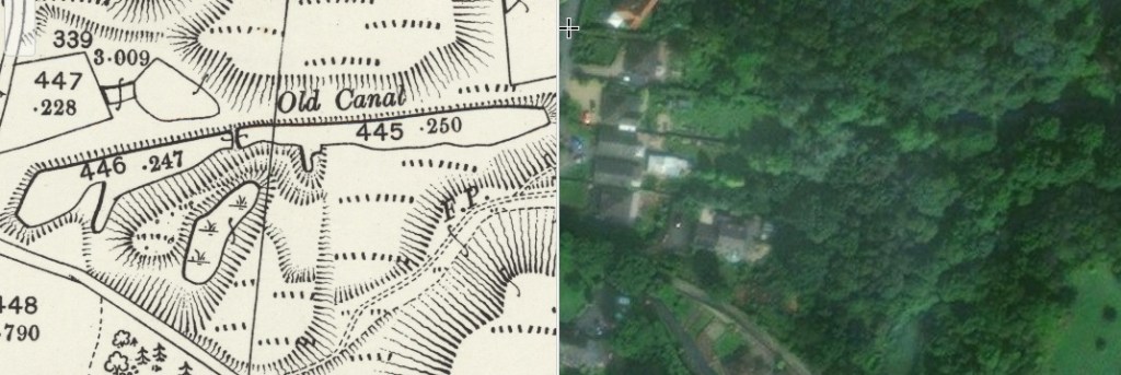
The canal entered a short tunnel under Shepherd’s Lane and emerged into Ketley Paddock Mound (as it is now called). The length of canal which is preserved in the nature reserve can be reached from a number of directions.
The route I took was to walk East along Holyhead Road to the bus stop adjacent to one entrance to Ketley Paddock Mound. The bus stop is a delight! It was painted in 2018 by Fran O’Boyle and funded by the Ketley Parish Council and the Friends of Ketley Paddock Mound. [10][11]

And I then entered the nature reserve through the gate visible in the photograph above. Immediately inside the gate is another public information board. The image below is an extract from my photograph of the board. …

This next sequence of photos shows the walk up to the remaining section of the Ketley Canal as highlighted on the map extract immediately above.


The walk back to my car took me over the top of the Paddock Mound which was the slag-heap made up of arisings from local pits and mines.
References
- https://maps.nls.uk/view/121150301, accessed on 2nd June 2022.
- T. Lowe; A Ketley Mon; British Bus Publishing Ltd., Wellington, Shropshire, 2000.
- https://www.facebook.com/groups/232901083430144, accessed on 31st May 2022.
- https://ketleypaddockmound.org/history, accessed on 2nd June 2022.
- https://historicketley.wordpress.com/ketley-wagonways-tramways, accessed on 3rd June 2022.
- https://maps.nls.uk/geo/explore/side-by-side/#zoom=18&lat=52.69405&lon=-2.47516&layers=168&right=ESRIWorld, accessed on 3rd June 2022.
- https://maps.nls.uk/geo/explore/#zoom=18&lat=52.69408&lon=-2.47518&layers=168&b=1, accessed on 3rd June 2022.
- https://en.m.wikipedia.org/wiki/Ketley_Canal, accessed on 3rd June 2022.
- http://www.canalroutes.net/Ketley-Canal.html, accessed on 3rd June 2022.
- https://ketleypaddockmound.org/how-to-find-ketley-paddock-mound, accessed on 3rd June 2022.
- https://www.shropshirestar.com/news/local-hubs/telford/2018/12/13/animal-magic-fran-transforms-telford-bus-shelter-with-wildlife-mural, accessed on 3rd June 2022.
- http://www.pittdixon.go-plus.net/shropshire-tbc/shropshire-tbc.htm, accessed on 4th June 2022.
- https://www.wikiwand.com/en/Tub_boat, accessed on 4th June 2022.
- https://ketleypaddockmound.org/how-to-find-ketley-paddock-mound, accessed on 26th January 2023.
- https://www.pogomap.info/location/52,695131/-2,473662/18, accessed on 26th January 2023.
