
 I first came across this ‘railway’ completely by accident.
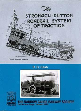
In a listing from a Google search for another matter, I came across the article by Henry Lubega below. I have discovered quite a bit more about the design philosophy since then. The system used for the line, the Stronagh-Dutton Roadrail System, is referred to elsewhere – particularly in “Narrow Gauge Steam … and other railway curiosities, Volume 1,” a ‘bookazene’ published by Kelsey Publishing [1] and in a relatively short publication by the Narrow Gauge Society. [2]
At first look, it seems quite an ingenious idea – removing the weight of the locomotive from the rails enabled much lighter rails to be used. In practice, however a whole series of factors rendered the idea impracticable.
There are a number of sources listed in the references at the end of this article, but it is worth drawing attention to http://dave-mills.yolasite.com/stronach-dutton-road-rail.php which has a significant number of images relating to this system and its use around the world. [7]
A film of theStronach Dutton system at work [12] … https://player.bfi.org.uk/free/film/watch-the-stronach-dutton-road-rail-tractor-1925-online
Henry Lubega speaks, in 2015, of ‘interesting colonial tractor trains that failed to take off in the 1920s and he talks initially of the death of this railway in the 1930s not long before the commencement of World War II. [3] Although later in his article he talks of it being operational until 1926. (The article is repeated almost word for word in the Daily Monitor of 14th March 2015.) [4]
Henry Lubega talks of two railways which were constructed in Uganda as feeder railways for the main Uganda Railway. There were actually three railways constructed in advance of the appearance the Uganda Railway.
One line ran from Jinja alongside the Nile to Namasagali, another ran from Port Bell into Kampala and the third was the railway from Kampala to Bombo.
The line to Namasagali (the Busoga Railway) is covered in an article which can be found on this link:
The Uganda Railway – Part 22 – Jinja via Mbulamuti to Namasagali
and in the history of the line on this link:
The Uganda Railway at the beginning of 20th century.
The route between Port Bell and Kampala had two different incarnations in the early years. The first was a monorail which is covered in the article you can find on this link:
A Monorail in Kampala?
The second was a metre-gauge line built some time before the Uganda Railway reached into Uganda. It superseded the monorail and provided for the transport of goods which had crossed Lake Victoria from Kisumu, the original terminal of the Uganda Railway. You can find out a little more about this line by following this link:
The Uganda Railway – Part 19 – Jinja to Kampala
The section referring to Port Bell comes towards the end of the linked article.
In addition, references are made to the line from Port Bell to Kampala in the historical account of the Uganda Railway based on M.F. Hill’s book, ‘Permanent Way’. For example:
The Uganda Railway at the beginning of 20th century.
The Kampala to Bombo line is not mentioned in the histories of the Uganda Railway. This is perhaps not surprising, as in many ways it was the pet project of the Governor of Uganda and was managed by the Director of Public Works. [2: p13]
Henry Lubega dates the Monorail from 1909-1914 and the Bombo line from 1923 to 1926. The Uganda Railway did not effectively extend beyond Jinja until the 1930s when the Nile Bridge was completed.
Lubega says that “the construction of the Kampala- Bombo road-rail was as a result of the consistent demand from the Uganda Chamber of Commerce and the Planter’s Association to the legislative council. A trial stretch was laid in 1920 from Kampala to Kawempe though the line from Kampala to Bombo did not operate commercially until 1st April, 1923. The following year, a branch of the Kampala–Bombo line to Gayaza was opened.” [3][4][5: p61]
This line was built mainly to facilitate the transportation of cotton from Bulemezi to Kampala, Although Lubega says that “there are speculations that it was built to ease transportation of military hardware to Bombo, hence it being known in some circles as the military railway.” [3][4][5: p61]
Writing in the Uganda Journal of March 1963, W. J. Peal says that “the railway used the ‘Loco-Tractor’ system invented by Frank Dutton of the South African Railways Motor Transport Department. [5: p61] Dutton patented the system in partnership with General Stronach of the Royal Engineers.
“The introduction of a novel form of light railway, cheap to construct and operate, aroused considerable interest. ” [5: p61]
“The major feature of these tractors was their large driving wheels which operated outside the rails on the roadway,” Peal says, and goes ahead to explain that the people behind these Loco-Tractors “claimed that it was capable of handling heavy loads on considerably steeper gradients than could be achieved by conventional railway locomotives.”
After the demonstration on 26th August 1920, of how the Loco-Tractor was to work, the Uganda Herald newspaper praised the new transport venture, saying: “Thus in a simple way has come what will in all probability prove to be the solution of the transport problems in the protectorate for if the tractor will do only half what is claimed for it, the results will be far reaching indeed. To H.E (His Excellency) who originated the idea of this form of transport in the protectorate are due the thanks of the community.” [5: p61-62]
The Development and Use of the Railway
While going for his annual leave in 1919, governor Sir Robert Coryndon left instructions with the then director of public works (the equivalent of a Minister of Works) Mr Claude Espeut to go ahead with experiments on the railway as soon as possible. Tracks were bought from the War Salvage Board for experimental purposes and a 300-yard (274-metre) track was laid near the Kampala station for the trials which were carried out in February 1920.
Trials were so unsatisfactory and public opposition so strong that the acting governor reported back to the colonies office saying: “The trials should be discontinued as they will take a much longer time to bear fruits yet the country’s transport needs were immediate.” [5: p62]
The governor, however, “insisted on having the project continue and he directed the director of public works to go ahead with the construction of a five-mile track, against the advice of all those concerned with the improvement of transport system in the country.” [5: p62]
The Governor, according to Peal, listened to two people whose advice he relied on in making his decision: “First was Frank Worthington, the governor’s brother-in-law, acting on behalf of road-rail Company in Uganda, who in September 1920 had applied to have his company construct the Mbale-Majanji railroad. The other was Major E. A. T. Dutton, the secretary to the governor and a relative to Frank Dutton, the inventor of the railway system.” [1: p62]. R.G. Cash, however, considers the two Duttons to be unrelated and of significantly different social standing. [2: p12]
By the time of Coryndon’s return from leave, the track from Kampala to Kawempe was complete and the trial run was done in August 1920. The experiment’s locomotive was a converted Ford Box motorcar from which the front axle and wheels had been removed to fit a rail bogie. The experiment journey from Kampala to Kawempe was covered in 12 minutes with a cotton cargo of three tons. [3]
Commenting on the experiment, The Uganda Herald of September 24, 1920, reported: “Perhaps more important, it convinced the members of the Chamber of Commerce of the potential of the road-rail.” [3]
In the Chamber of Commerce’s next sitting after the experiment from Kampala to Kawempe, it was resolved that “the chamber approves of the decision of the government to order a further 50 miles to be laid along Bombo Road. The chamber would welcome the opportunity of giving its opinion on the most suitable routes for any extension to be placed”. [3]
“One of the main attractions of the railway was how it was laid along the edge of the existing roads, for it to serve the public better by going through existing towns and villages. Some sections of the public were disappointment when government decided to reroute the Bombo railway along the Kitante valley from South Street because some sections of the drainage on Bombo road were badly affected during the rainy season. … Another reason was that it was better for the railway not to run through the centre of Kampala in order to avoid traffic distraction and the necessity to maintain level crossings.” [3][5: p64]
Upon completion of the construction of the track, two tractors were imported in mid-1922, however, in a joint report by the directors of public works and transport — G.N. Loggin and Major R.B. Hill respectively — entitled “The Stronach-Dutton system of road rail transport as in operation in the Uganda protectorate,” they stated: “As these two tractors were the first to be constructed much trouble and expense had been incurred locally in remedying the defects in both engines and chassis.” [3] [5: p64]
The first two tractors did not perform well. Replacements were ordered which arrived in May 1924. The Uganda Herald was skeptical. It predicted their failure. At first it seemed to be vindicated as without adaption, the tractors could not operate efficiently on wood fuel. It was the intervention of the foreman from the Busoga Railway which resulted in changes to operating procedures that they started performing to expectations.
However, in service, the railway did not perform well. In 1924 an average of 100 tons of cotton were produced in the Bombo region. The most that could be transported in one trip was 15 tons and only 46 trips occurred in the whole of that cotton season between March and May.
A commission of inquiry headed by Major Rhodes, the chief engineer of the Uganda Railway was set up. That commission concluded that the tractors would have been far more efficient using coal as fuel rather than wood or parafin and that maintenance of the permanent way required improvement. [5: p65]
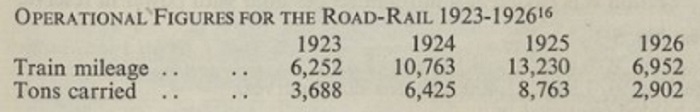
“In 1925, the Uganda railway recorded its highest transport tonnage, but the following year it nosedived to its lowest. The fall was due to handling procedures at Kampala station, forcing ginners to resort to sending their cotton direct to Port Bell by motor vans than the railway.” [3][5: p65]
On 31st December 1926, the line was closed. Its performance is summarised by Peal in a small table which he gleaned from a letter sent by F. J. Hopgood: [5: p65]
The route followed by the line is illustrated on an sketch map which Peal included in his article in The Uganda Journal [5: facing p62] and which is reproduced below:
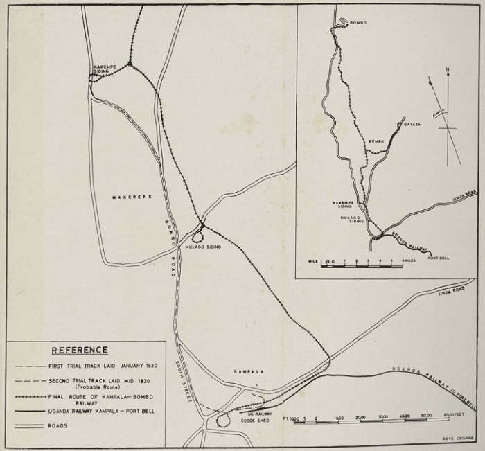
The Kampala to Bombo Railway. The loops of track shown on the enlarged view were required because the locomotives were unable to reverse! [5: facing p62]
The Road-Rail system was unable to pay its way. Despite providing attractive rates, customers were not willing to entrust their product to the railway because it was unable to function with sufficient reliability to compete with road transport. Peal provides income and expenditure figures [5: p68] which he extracted from the Director of Public Works’ final report on the line: [6]
Locomotives
Peal provides details in his article in The Uganda Journal [5] of the ‘locomotives’ used on the line. He provides 4 illustrations which cover: first, in figures 2 & 3, the Guy-engined tractors [5: facing p66] and secondly, a prototype of the William Beardmore supplied steam tractors. [5: facing p67]
Locomotives used on the line were: [5: p65-67]
- A Lacre 2-Ton van (1920 trials – locally converted road vehicle [2: p44])
- A Ford box car (1920 trails – locally converted road vehicle [2: p44])
- An Albion 32h.p. Lorry (converted locally, used for short journeys and shunting).
- Two Guy-engined Tractors (each had two 25h.p. internal-combustion engines).
- Two Steam Tractors (built by William Beadmore with Sentinel boilers [2: p46]).
R.G. Cash tells us that the two Guy-engined tractors were provided with bogies made by John Fowler & Co of Leeds. [2: p44] By the time these were supplied William Beardmore had become the sole supplier of Stronach-Dutton locomotives. [2: p24-25, p46]
Rolling Stock
Peal tells us [5: p67] that the Kampala to Bombo line had:
- 10 No. 6 ton covered bogie wagons.
- 2 No. 6 ton covered bogie wagons.
- 2 No. bogie passenger cars each with a 28-person capacity
- 20 No. 8 ton bogie platform wagons
Stations and Signalling
Peal notes that three locations were provided with lockable sheds which served as stations and goods yards. These could be found at Kampala, Gayaza and Bombo. they allowed goods and rolling stock to be stabled overnight. Each was 116ft x 25ft in size and in each case the line passed through one side of the structure, leaving the remaining 16ft width for the handling of goods. [5: p67]
Signalling was felt unnecessary as traffic was controlled by a self-contained telephone system. [5: p67].
 The Route of the Line ……
 I have been unable to find much in the way of records of the route of the line. However, based on Peal’s sketch map above, The line appears to have run Northeast along the modern Station Approach and Station Rd in Kampala to the junction between Station Road and what is now Yusuf Lule Road. The line seems to have followed the verge of Yussuf Lule Road, crossed the modern Kira Road at what is now Mulago Roundabout. There was a short branch at this location noted on Peal’s sketch plan as Mulago siding. At the end of the siding closest to the Bombo Road, there was a turning loop. That siding is not shown on the adjacent satellite images as its location is at the junction of the first two images.
I have endeavoured to transfer the probable/ possible route of the line to the adjacent satellite images. In some places the route seems relatively obvious and road alignments seem to support the existence of the old line at those points – these lengths are shown as a solid red line imposed on the satellite images sourced from Google Maps. However, even though shown as solid lines, the route should be considered probable rather than likely and others with better local knowledge my need to correct my assumptions.
 In other locations, the route of the is shown with red dashes. At these points on the line, I cannot be sure of the route taken by the line, only that the line traveled through the area. At these locations the line shown should be considered as possible rather than probable. Again, I should be delighted if others with greater knowledge can correct my assumptions.
Please note, also, that the mapping follows the line South to North, rather than North to South. This means that the top of the first image will marry with the bottom of the second image … and so on.
 It is worth noting that in Kampala and its suburbs, even if any remnant of the line existed as long as the middle of the 20th century, the modern intensive use of tarmac on main roads in the city and its suburbs will have completely covered any possible remnants of the narrow gauge line.
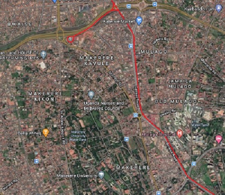
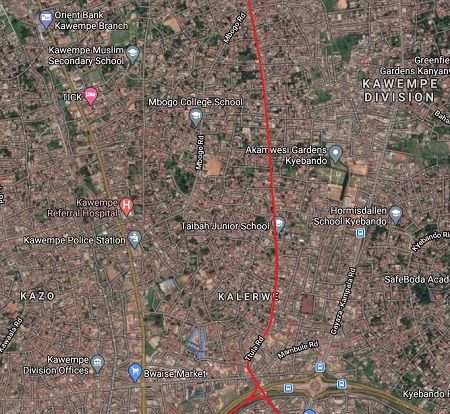
 The line then followed the verge of what is now the Binaisa Road, passing Mulago Hospital and on towards the junction with the Bombo Road. There is now a roundabout at that point. The line did not, however, follow the Bombo Road, it seems to have more closely followed what is now the Gayaza Road on the East side of the Kalelwe River. It seems to have crossed the Gayaza Road in the vicinity of Kalerwe Market.
 A short siding ran close to what is now the line of the Kampala Northern Bypass Highway, west towards the Bombo Road. This branch was known as the Kawempe Siding. It terminated in a loop adjacent to the Bombo Road. From this point Northwards the Bombo Road is marked on current maps as the Kampala-Gulu Highway or the Kampala-Masindi Highway.
North of the Kawempe siding the mainline followed a course between the Gayaza Road and the old Bombo Road. The route drawn by Peal approximates to the line of the Ttula Road. This appears on the third and fourth satellite images.
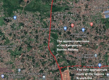
 On the fifth image, a longer branch can be see diverging from the mainline to Bombo. As noted earlier, I have shown the first length of this branch-line in red dashes because it is impossible to tell what the alignment may have been over the first few hundreds of yards until the branch reached the Kampala-Gayaza Road.
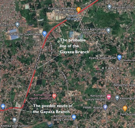
 The next few satellite images follow the assumed route of the branch-line alongside the Gayaza Road. On his sketch map (above), Peal shows the line following the road through to Gayaza.
There is little to note about this branch-line except perhaps its length. It was about 7 miles long, according to Cash. [2: p30]
 Wikipedia tells us that in the early 20th century, Gayaza started as a road junction, where the road to Gayaza High School branched off the main road from Kampala to Kalagi.
Shops began to appear in the middle of the century when the Uganda Ministry of Agriculture opened an agricultural research center at Namulonge. Later, Makerere University opened a crop and animal farm at Kabanyolo to cater for the faculties of Agriculture and Veterinary Medicine.
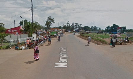 Today, the township continues to grow and is continuous with Kasangati, a short distance to the south-east. [8] included in the run of satellite images is a typical Google Streetview image of the main road approaching Gayaza. The old narrow gauge branch line was alongside the old road which would have been much narrower.
Returning to the mainline, I have repeated the satellite image which shows the approximate location of the junction between the Gayaza line and the Bombo line. That appears just below the Streetview image of Gayaza.
It is difficult to be sure that the line I have chose to illustrate is the actual line of the Bombo railway. It seems from examination of the staellite images and Peal’s sketch (above) to be the most likely. I have, as elsewhere in this article assumed that, in general, the road alignment followed by the line will have survived, or that the presence of the line in the 1920s would have established a more widely used right-of-way which over the decades has become more established.
The mainline continued North along the West side of Mpererwe. Even in the 21st century its surroundings are increasingly rural and we are approaching the limits of the Streetview images available through Google Maps.
 That the alignment of the railway shown on the satellite images is at best tentative is perhaps best illustrated by a further Streetview image of what I think was the route of the line back in the 1920s. The image was captured in 2015. It shows the North-South road on the satellite image just to the north of the probable location of the junction between the Bombo and Gayaza lines.
Wikipedia tells us that Mpererwe is a trading centre that is gradually turning into a busy commercial area. Schools, gas stations, small-scale factories, hospitals, and a cinema hall are in this neighborhood. In up to 50 percent of homes, backyard urban agriculture is practiced. Because of the rapid urbanisation rate coupled with high unemployment, particularly among young people, the area is prone to crime. Despite those challenges, the neighborhood remains close-knit, with a modest cost of living compared to other areas of the city. [9]
 The mainline probably continued in a generally Northerly direction through Kiteezi, which had a large landfill site to its Southeast. The Uganda Observer carried a short article about the landfill site in 2013, written by one of the site managers. [10]
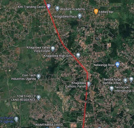 It then turned more to the Northwest beginning to drift towards the Bombo road from Kitagobwa.
 These areas seem quite built-up on the Satellite images but much development is single storey and dispersed.
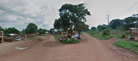
 The next Google Streetview image shows the location of the junction between the Kigaga Road and the road to Kiti in the village of Kitagobwa. If I have the line of the railway correct, it followed the left fork in the Streetview image – to the left of the large tree in the centre of the picture.
 The line passed to the Southwest of Kiti. The village/town is off to the right of what appears to be the alignment of the old narrow gauge railway. The railway followed the right fork in the Streetview photograph – essentially straight-on from the camera.
Beyond this point Google has not yet provided Streetview images and we will have to rely on just the satellite images from Google Maps.
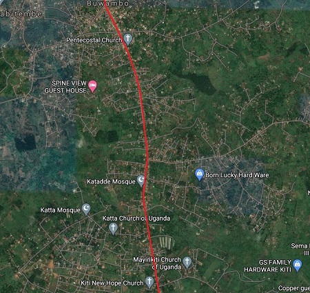 The next district along the presumed route of the old railway is Buwambo which appears at the top of the next segment of the satellite imagery.
 North of Buwambo, running through Migadde, there is much more uncertainty over the line followed by the old Railway, There are no roads following the approximate route shown in Peal’s sketch map above.
 The old railway route is represented by red dashes through this area as it approaches the main Bombo Road – the Kampala – Gulu Highway.
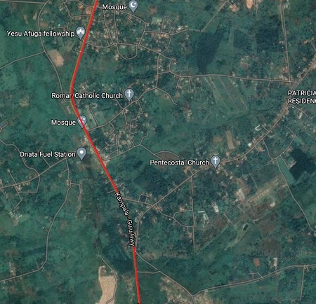 North of Migadde, which straddled the Kampala-Gulu Highway, the narrow gauge Road-Rail line followed the verge of the old main road. Before branching away to the East-Northeast towards Bombo Town.
 Bombo was the ultimate destination of the line. It has been a relatively significant centre since the formation of the Uganda protectorate.
It was an important cotton growing area at the time that the Kampala to Bombo Railway was operational. It was cotton growers need for good transport that saw the railway built and it was its failure to meet the needs of the cotton growers which meant its failure and its closure were sealed.
Wikipedia carries details of the history of Bombo, but only from the 1960s. [12] ……
The area in which Bombo town is a main township became Bombo District, one of the first regions that initially received district status when Uganda became independent in October 1962.
In 1967, the district was renamed East Mengo. In 1974, Uganda reorganized from districts into provinces, and East Mengo became the Province of Bombo.
Provinces were reorganized into districts in 1980, and the district of Luwero was created, with Bombo town as one of the main town councils.
Many officers and soldiers of the Uganda Army (UA) settled in Bombo upon their retirement during the Second Republic of Uganda (1971–79). At the time, many inhabitants were Nubians, an ethnic group whose members were viewed as supporters of President Idi Amin.
The town also hosted the barracks for the UA’s Malire Regiment. As a result, Bombo was affected by the Uganda–Tanzania War. After Idi Amin’s government had been factually overthrown and Kampala been captured by the Tanzania People’s Defence Force (TPDF) as well as allied Ugandan rebels on 11 April 1979, UA soldiers of Nubian origin as well as their families began to terrorize other locals in Bombo.
After several killings, many younger soldiers fled the town, but the retired officers set up defenses to oppose the TPDF’s 201st Brigade that was approaching the town from the south. … The Battle of Bombo in April 1979 resulted in a Tanzanian victory. Several Ugandan defenders were killed, much weaponry was captured by the TPDF, and the town suffered substantial damage. Many Nubian, Kakwa, and Lugbara locals subsequently fled the town, fearing reprisals by anti-Amin groups.
Following the war’s conclusion, Bombo was not provided with relief aid like other settlements, as the new Ugandan government suspected its large Nubian population. Many buildings in the town continued to display damage suffered during the 1979 battle for decades.
Bombo’s barracks continued to be used during the Ugandan Bush War, and the Uganda National Liberation Army was known to imprison civilians there from 1981.
In the 1980s, Kenya forced many former Nubian inhabitants of Bombo to return to Uganda. They were denied refugee status, and often fell into poverty.
In 1995, Bombo was also stripped of its municipality status. Since then, locals have struggled to regain this status.
Encyclopedia Britannica notes that Bombo, town is located in south-central Uganda about 23 miles (37 km) north of Kampala. Located in an agricultural region, it is a centre of trade for cotton, coffee, and bananas. Industries produce plywood and other wood products, footwear, beverages, textiles and apparel, rope and twine, glass, and structural clay products. The Encyclopedia records the population in 2008 as 19,400. [11]
As we noted above, the Stronach-Dutton Roadrail system was only in use in Uganda for a few years in the 1920s. The route shown on the satellite images above assumes that Peal’s sketch map can be accepted as drawn and assumes that for the major part of the route of the line existing highways were followed, or the presence of the railway resulted in a public right of way becoming established. There are, however, gaps in the suggested line which may mean that too many assumptions have been made about the route followed. If other people have more, or better, information, it would be good to hear from them and then to adjust this article.
References
- Derek Rayner; The Stronach-Dutton Roadrail System; in ed. Paul Appleton, Narrow Gauge Steam … and other railway curiosities, Volume 1, Kelsey Publishing Ltd, Yalding, Kent, 2020, p72-79
- R.G. Cash; The Stronach-Dutton Roadrail System; in series ed. Alan Burgess; The Narrow Gauge; Special Issue No. 234; The Narrow Gauge Railway Society; Autumn 2015.
- http://www.kabakayekkaonline.com/entambula.html, accessed on 16th March 2021.
- https://www.monitor.co.ug/uganda/news/insight/death-of-the-kampala-bombo-railway-1603892, accessed on 16th March 2021.
- W.J. Peal; The Kampala to Bombo Railway; in The Uganda Journal, Volume 27 No. 1, March 1963, p61-70, via https://www.wdl.org/en/item/13842/view/1/65, accessed on 16th March 2021.
- Entebbe Archives No. 6085 (Loco-Tractor) Part III, via via https://www.wdl.org/en/item/13842/view/1/65, accessed on 30th March 2021.
- http://dave-mills.yolasite.com/stronach-dutton-road-rail.php, accessed on 20th March 2021.
- https://en.wikipedia.org/wiki/Gayaza, accessed on 2nd April 2021.
- https://en.wikipedia.org/wiki/Mpererwe, accessed on 2nd April 2021.
- https://www.observer.ug/viewpoint/guest…/23761-heres-the-truth-about-kiteezi-landfi…, accessed on 2nd April 2021.
- https://www.britannica.com/place/Bombo-Uganda, accessed on 2nd April 2021.
- https://en.wikipedia.org/wiki/Bombo,_Uganda, accessed on 2nd April 2021.
- https://player.bfi.org.uk/free/film/watch-the-stronach-dutton-road-rail-tractor-1925-online, accessed on 3rd April 2021.

The BFI film jumps around on various continents, but at 14 minutes in it shows the system operating at the 1924 British Empire Exhibition in Wembley. I’m wondering if my 15 year old father appears…