
We begin the next stage of our journey in Eldoret Station. The first picture shows Charan Singh Kundi aboard his train (Class 58 Garratt No. 5817) bound for Kampala from Eldoret. [1]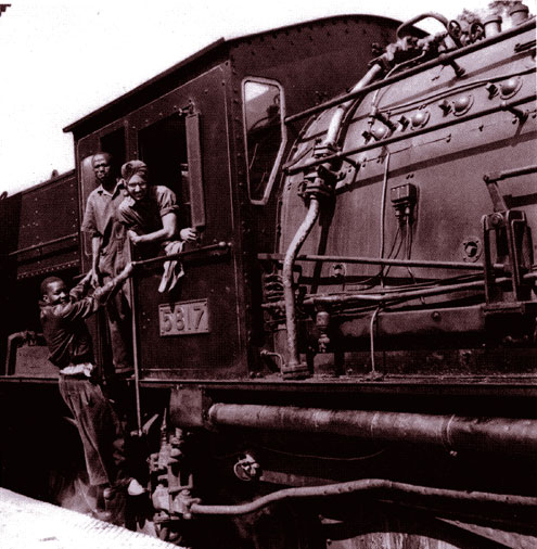
 Shunting Eldoret Yard. [2]
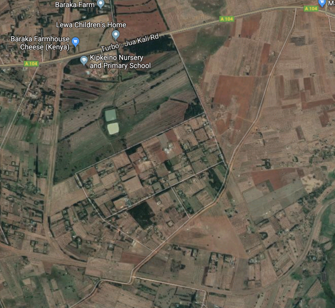
Rather than taking the main line towards Kampala, we are first going to take the branch-line to Kitale. Some 20 kilometres to the West of Eldoret the branch to Kitale diverges north from the main line. It’s route is shown on Open Street Map as a dotted line as can be seen below. [7] Its route can be just as easily picked out on the Google Earth satellite image as well.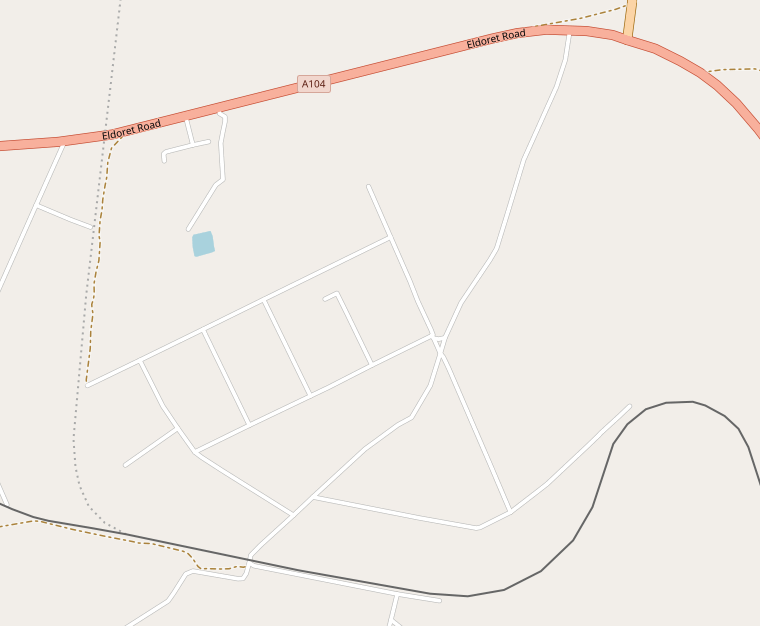
 En-route to Kitale the railway passed through 3 stations … Soy, Springfield Halt and Moi’s Bridge. for much of its route it is followed by an unnamed and unnumbered secondary road. Soy Railway Station was perhaps 3 kilometres from the village with which it shared its name.
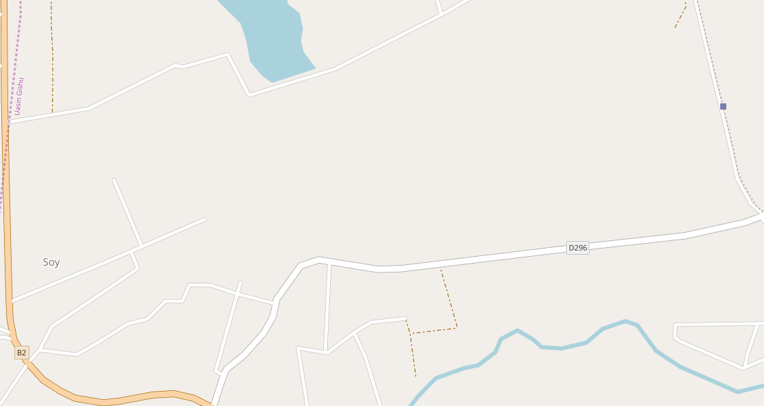
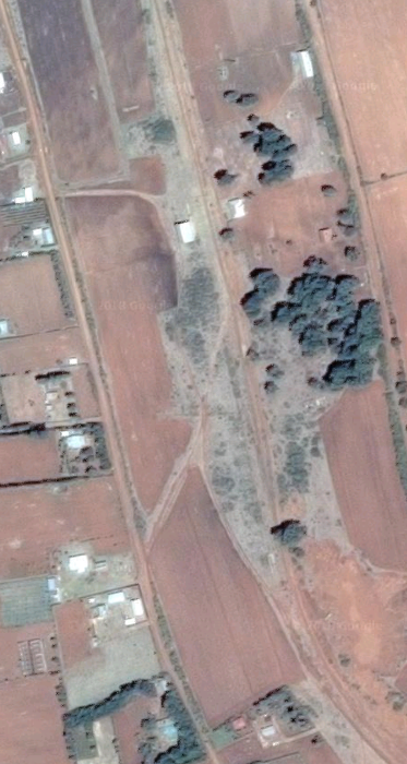
The satellite image is the best we can do to show the station, which appears to have a passing loop and some simple buildings but nothing more. From Soy the branch-line ran some 8 kilometres in a northerly direction before swinging round to the west.
It joined the line of the B2 road and swung north-west and then north once again. As the railway approached Moi’s Bridge it swung sharply through 180 degrees and then back again to the north. I have carefully checked the line of the railway and the B2 road but cannot find any evidence of Springfield Halt. Perhaps someone wiser than me can say where it is (or was).
Over some significant distance the railway has followed a relative straight path alongside the B2. The need to snake around will have been dictated by the contours of the land. The map below shows the route taken. We are still some kilometres south of Moy’s Bridge, so it is possible that Springfield Halt is/was close to this settlement, although it is not visible on Google Earth. On its way to Moy’s bridge the railway now meanders around before entering Moi’s Bridge Railway Station travelling in a easterly direction. The blue dot on the map below gives the location of the railway station and the bridge over the River Nzoia can be found adjacent to the ‘B2 road-marker.
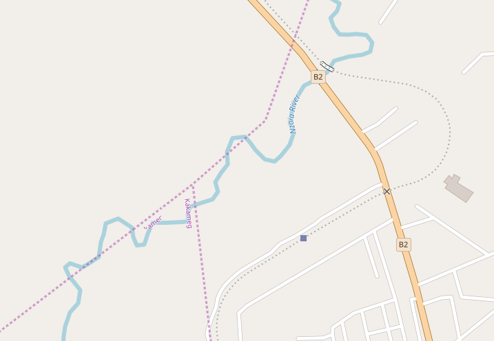
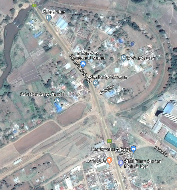 In the satellite image above, Moi’s Bridge Station is in the bottom left and the bridge is just off the top of the picture. The satellite image below is the best overhead image of the bridge available.
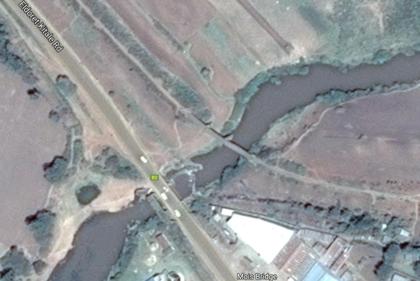

However, I have been able to find a video from which I have obtained this photograph. It is not the most stunning shot of the bridge but it does help to understand it construction. It seems to be a three span simply-supported girder bridge with the largest span to the south-east and spanning the river.
After Moi’s Bridge the railway follows the B2 in a generally north-westerly direction until it reaches the suburbs of Kitale. In the centre of the town the railway finishes its journey adjacent to the C45 road – the Mumia Highway.
These next few pictures are taken on the approach to the branch terminus at Kitale. They can mainly be found on the Railway Ramblers website. [3] These pictures were taken in 2009. In 1983, Kitale station was still in use as a goods terminus but passenger services had long-gone. In 1983, a significant amount of the supplies, including food, for a major famine relief project in the Turkana district to the north of Kitale came in by rail and was forwarded by road. There was a Barclay 0-8-0 class 46 shunter stationed there and the regular branch engines were EE 1Bo-Bo1 of class 71 or 72. [4]
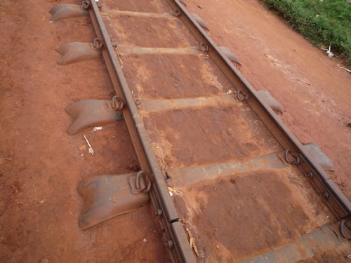
A close-up of the permanent way, viewed about a kilometre south-east of Kitale station. As can be seen, there is no ballast, although the country’s operational lines are ballasted. This makes it possible that any ballast here has simply settled into the clay. The sleepers are made from neither wood nor concrete but metal, designed so as to grip the clay effectively and (presumably) prevent the whole structure from sinking into the ground when wet. A rail joint with fishplates can be seen in the foreground, while the keys holding the rail to the sleeper are of a fairly modern spring type, used in the UK during the mid 1970s. The tracks of bicycle tyres can be made out between the rails. The demand for Sustrans-style rail-to-trail conversions would be very limited in Kenya, since the locals just help themselves. The empty railway is a far more pleasant way of getting into Kitale than the noisy main road, where vehicles emit amounts of exhaust that would send British clean-air campaigners into a frenzy. The stench of diesel fumes on Kenya’s roads is not a pleasant experience, (c) Jeff Vinter. [3]
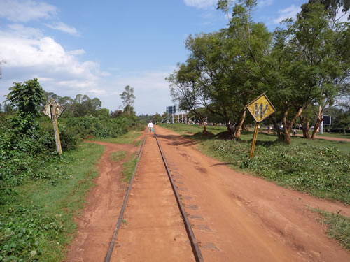
A typical view along the trackbed, looking north west towards Kitale. The W signs, one facing each way, instruct the driver of oncoming trains to sound his whistle – not for the footpath crossing seen in the foreground, but for the level crossings in front of and behind the photographer, (c) Jeff Vinter. [3]
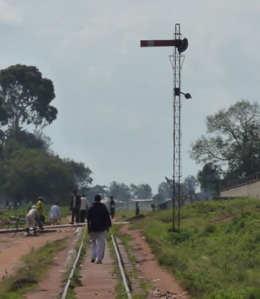
The home starter signal for entering Kitale station yard. The signal is an unusual combination of British styles, using the lattice structure common on the LSWR but the lower quadrant board common on the GWR, (c) Jeff Vinter. [3]
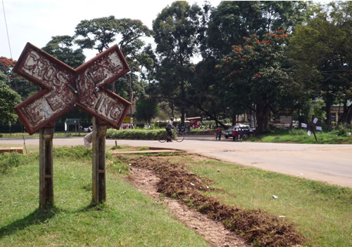
The level crossing seen in the background of the photograph above is still protected by this substantial sign, although its neighbour on the far side has begun to topple over (look for the white-painted ends of its arms). Signs like this abound all over the Kenyan railway system, on lines both open and closed. Unusually, this road is made of tarmac and is not full of potholes! (c) Jeff Vinter. [3]
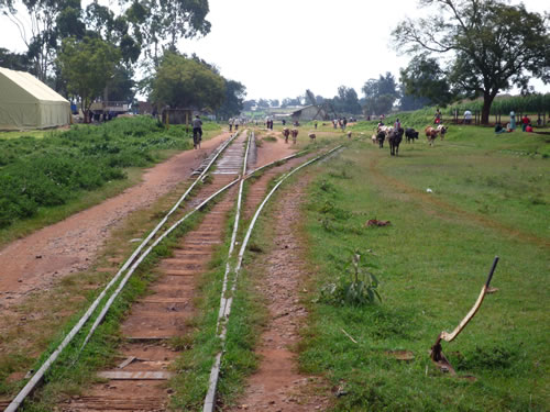
The points (turnouts) to Kitale goods yard. As can be seen, the point lever is still in place, as are all of its counterparts throughout this large yard, (c) Jeff Vinter. [3]
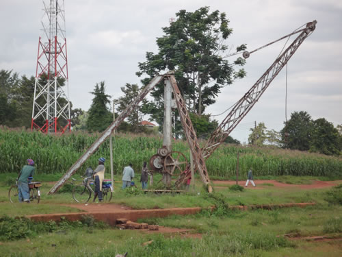
The crane in the old goods yard survives. Presumably, it is still capable of working, since all the cables and pulleys remain in place – albeit somewhat rusty and in need of lubrication, (c) Jeff Vinter. [3]
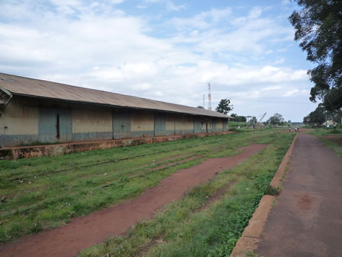
A view looking south eastwards along the departure platform of Kitale station. The massive building on the left is the extensive goods shed, The crane in the picture above can just be made out in the distance, silhouetted against the sky, (c) Jeff Vinter. [3]
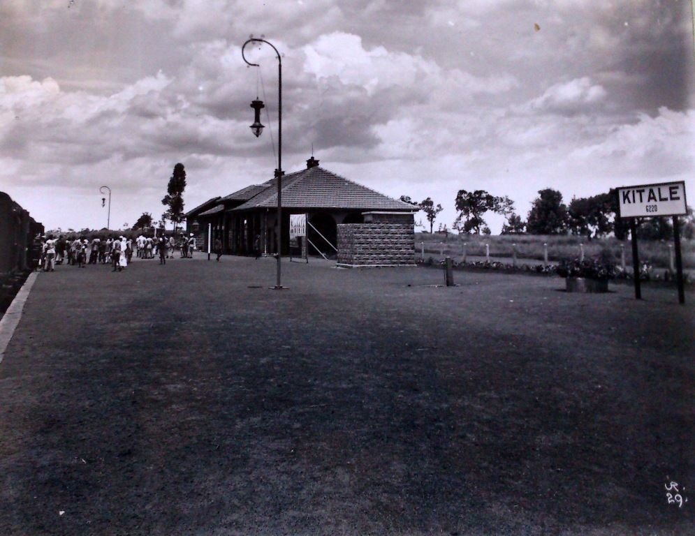
A picture of Kitale Station building taken in 1929. [5]
Kitale station, viewed from the goods yard, was equipped with only a single platform, although it was very long. The station’s design is what one would expect of a colonial structure built in the early 20th century with its elegant arches and colonnades. The departure road is covered in grass but the rails can just be made out, while the rails in the foreground belong to the main running line within the goods yard. The small stone building behind the telegraph pole was the station master’s office, (c) Jeff Vinter. [3]
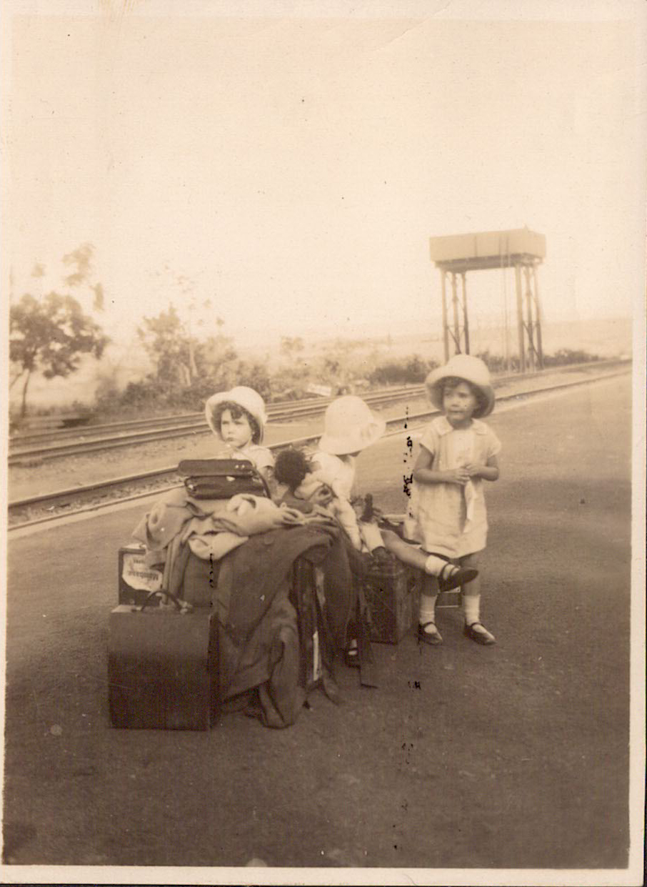
The picture above was taken in 1930 at Kitale. It shows a small family waiting to take the train which will eventually lead to them returning to the United Kingdom. [6]
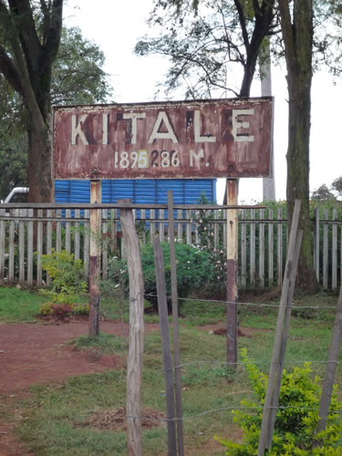
The running-in board at Kitale station is set some way back from the platform at an angle to approaching trains, presumably so that drivers and passengers could see it better. It declares the station to be 1,895.86 metres above sea level. The original height would probably have been shown in feet, (c) Jeff Vinter. [3]
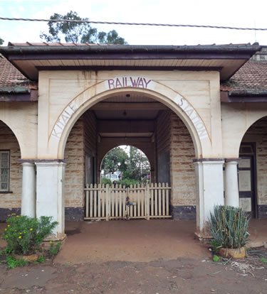
The exit from the platform at Kitale station was suitably grand and still proclaims ‘Kitale Railway Station’, perhaps over 30 years after the last train ran. The door visible behind the colonnade on the right indicates that the railway’s livery was similar to the GWR’s famous ‘chocolate and cream’. After years of neglect, the platform surface is beginning to break up, but it is still in better condition than many of the country’s roads, (c) Jeff Vinter. [3]
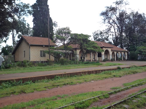
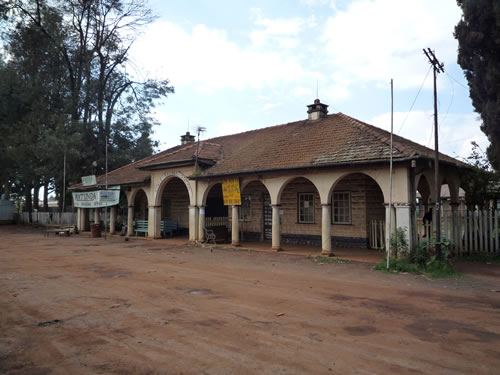
Kitale station, viewed from the street, has the same colonial styling as on the platform side. The building still, in part at least, serves a public transport purpose, since the banner hung from the guttering on the left advertises the booking office of Matunda Buses. Often, one of Matunda’s vehicles will be seen parked outside, (c) Jeff Vinter. [3]
We finish this post on the concourse outside Kitale Station and prepare to return to Eldoret for the onward journey to Kampala.
References
- http://www.sikh-heritage.co.uk/heritage/sikhhert%20EAfrica/sikhsEAfrica.htm, accessed on 27th May 2018.
- https://www.google.co.uk/search?q=eldoret+railway&client=tablet-android-lenovo&prmd=mniv&source=lnms&tbm=isch&sa=X&ved=0ahUKEwjXivnk3abbAhUIXMAKHfuPAl8Q_AUIEygD&biw=800&bih=1280#imgrc=4F4p_HGkxIV9gMHGkxIV9gM, accessed on 27th May 2018.
- http://www.railwayramblers.org.uk/photo/35photo.htm and http://www.railwayramblers.org.uk/photo/36photo.htm, accessed on 27th May 2018.
- Paul Taylor; http://www.railwayramblers.org.uk/photo/35photo.htm, accessed on 27th May 2018.
- https://www.theeagora.com/the-lunatic-express-a-photo-essay-on-the-uganda-railway, accessed on 21st May 2018.
- http://www.hilarymunro.com/?p=736, accessed on 28th May 2018.
- https://www.openstreetmap.org/#map=15/0.5927/35.1861, accessed on 28th May 2018.

Springfield Halt was situated about 4miles after Mois bridge and 8mies before Kitale station! I will be glad to foward a photo
Brilliant Joe. I’d be very happy to include it with a credit to you.