Category Archives: West Midlands

The Railways of Worcester – Part 1 – The ‘Vinegar Works Branch’ or ‘Lowesmoor Tramway’ – An Unusual Branch at Worcester

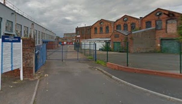
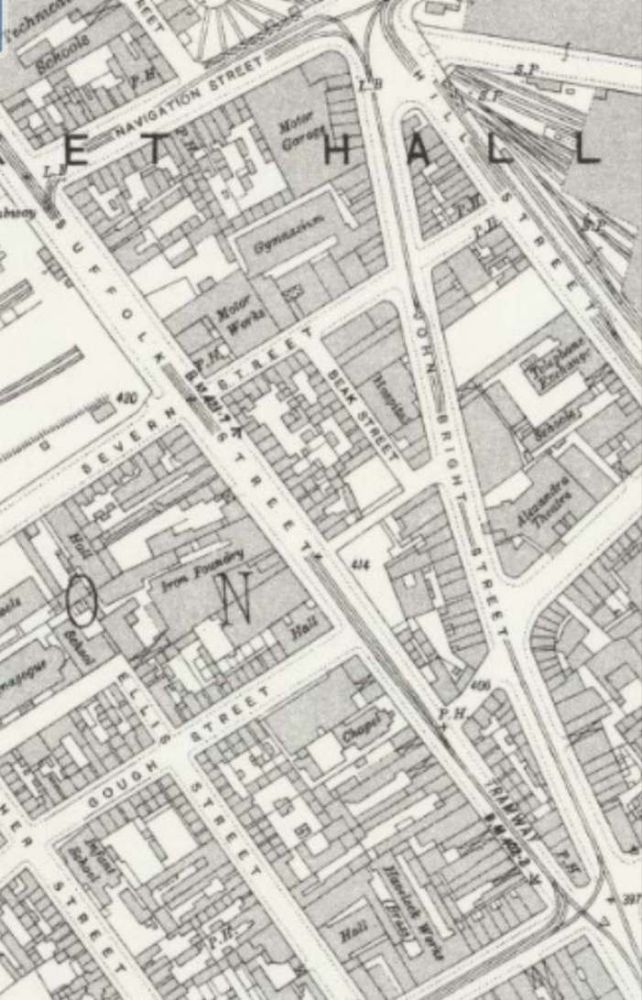
The Railway Magazine of April 1959 carried an article by Anthony A. Vickers about a short branch in Worcester of about 29 chains in length. [1] 29 chains is  638 yards (583.4 metres). The line served Worcester’s Vinegar Works.

After a time operating at their Vinegar Works in Lowesmoor, Worcester, Hill, Evans & Co. decided that a connection to the national railway network was required via the nearby joint Worcester Shrub Hill railway station which at the time served both the Oxford, Worcester and Wolverhampton Railway and the Midland Railway.
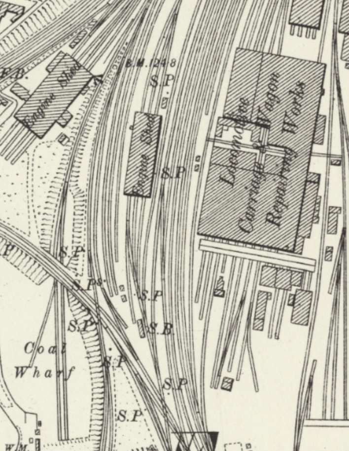
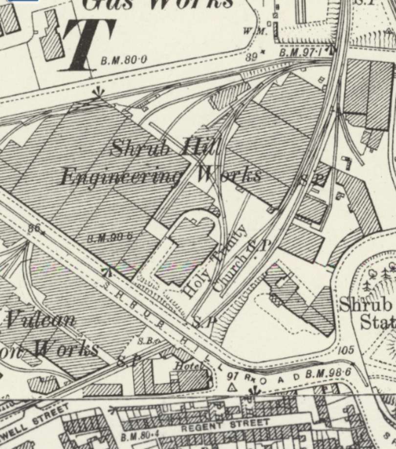
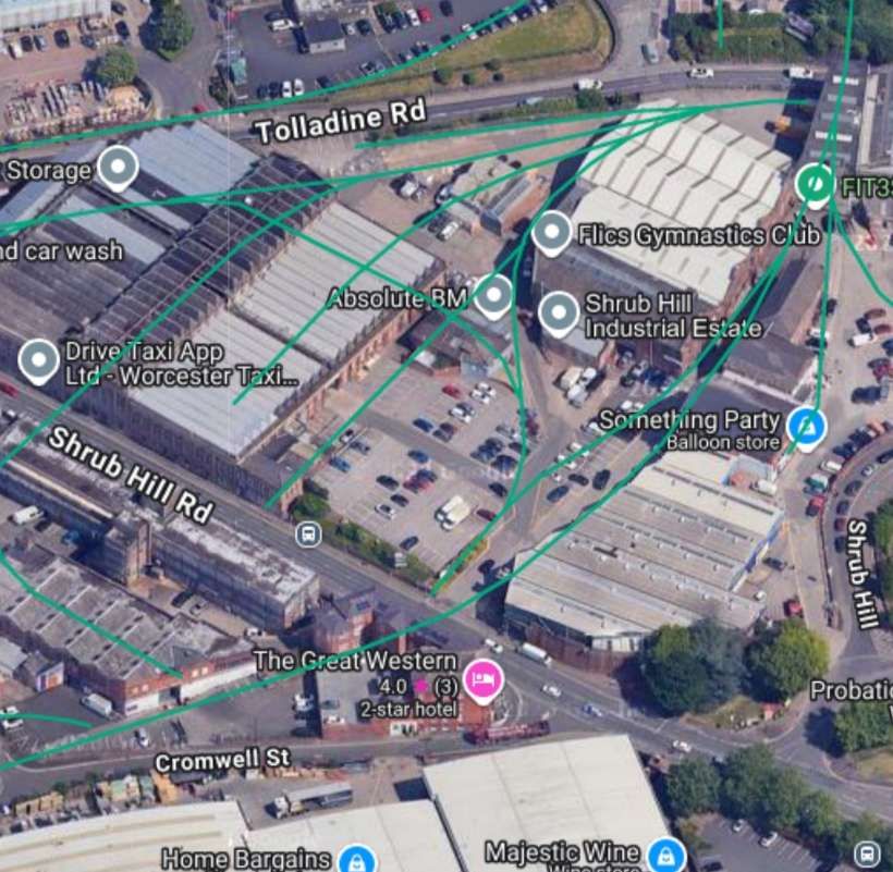
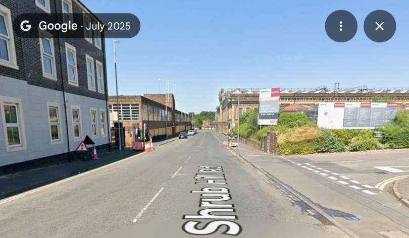
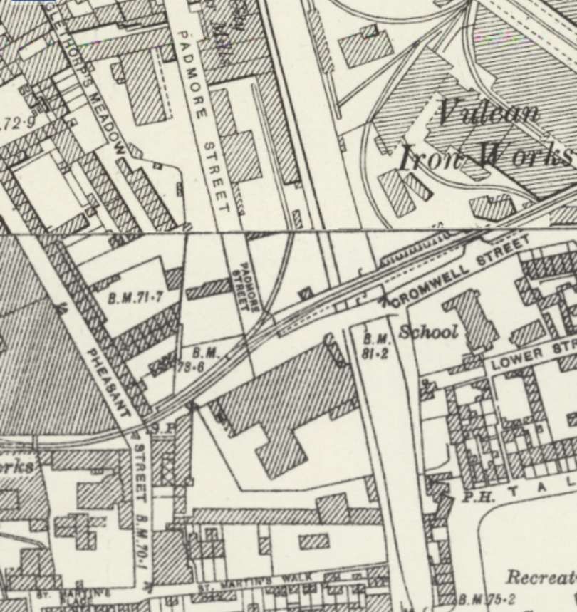
The resultant Worcester Railways Act 1870 allowed Hill, Evans and Co to extend the existing branchline that had served the Worcester Engine Works, from where it crossed the Virgin’s Tavern Road (later Rainbow Hill Road and now Tolladine Road) by a further 632 yards (578 m) to terminate in … the vinegar works. This route required a level crossing at Shrub Hill Road, a bridge over the Worcester and Birmingham Canal, and a second level crossing at Pheasant Street.[3] The Act also permitted a second siding to be constructed that was wholly within the parish of St.Martin, which enabled the branchline to connect to both the local flour mill, and the Vulcan Works of engineers McKenzie & Holland.” [6]

One of the provisions of the Act, was that signals must be provided at the public crossings to warn the public when trains required to cross. The speed of the latter was also to be limited to 4 m.p.h.” [1: p238]

A.A. Vickers notes that a few years prior to his article, “a Land-Rover was in collision with a train on Shrub Hill Road level crossing. It is understood that legal opinion of the question of liability was sought, and was to the effect that the semaphore signals fulfilled the obligations of the railway to give adequate warning of the approach of a train, and that the attendance of a shunter with red flags was unnecessary. Be that as it may, road traffic pa[id]no heed to the semaphores, being mostly unaware of their significance.” [1: p238]

The branch was completed in 1872 and was known as the Vinegar Works branch or the Lowesmoor Tramway. As an engineering company, McKenzie & Holland supplied the required shunting locomotive. From 1903, engineering company Heenan & Froude also built a works in Worcester, which was served by an additional extension. After the closure of the flour mill in 1915, post-World War I that part of the branchline was lifted, and the flour mill and original part of the Vulcan Works redeveloped in the mid-1920s as a bus depot. In 1936, Heenan & Froude took over McKenzie & Holland, and hence responsibility for the supply of the private shunting locomotive.” [6]

Post World War II, the Great Western Railway and then British Railways took over supply of the shunting locomotive to the branchline. Supplies to the vinegar works switched to road transport in 1958. The last train on the branchline ran on 5th June 1964, hauled by GWR Pannier Tank engine 0-6-0PT No.1639. The branchline was taken up in the late 1970s.

Although the line was short it had a number of interesting features!

The line ran South between the two engines shed on this extract from the 25″ Ordnance Survey of 1901/1902, published in 1904, © Crown Copyright. [2]
The same area in the 21st century. This is an extract from railmsponline.com’s satellite imagery. The route of the line that we are looking at is marked in green and runs down the centre of this image. [4]
This aerial view looks West across the same area in 1934. The two engine sheds are on the right of the image. One of the sidings between them can be seen extending across the southern arm of the triangle. This is an enlarged extract from Britain from Above Image No. EPW044990, © Historic England. [12]

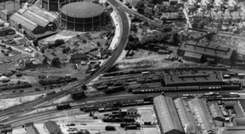
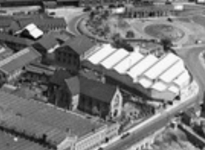
The line crossed the south loop of the junction, and then by a bridge over what A.A. Vickers tells us was, at the end of the 1950s, Rainbow Hill Road (now Tolladine Road). The line then ran through Shrub Hill Engineering Work, curving gradually round towards the Southwest.

The line runs from right to left across the centre of this enlarged extract from EPW044990, beyond (to the West of) the main line, © Historic England. [12]
This enlarged extract from another of the aerial images provided on the Britain from Above website, No. EPW044987 which faces East, shows the line curving round beyond Holy Trinity Church and then crossing Shrub Hill Road, © Historic England. [13]
The line crossed Rainbow Hill Road (now Tolladine Road) and curved towards the Southwest as it ran through Shrub Hill Engineering Works, crossing Shrub Hill Road by means of a level-crossing (despite being shown on the 25″ OS map extract as passing under the road). It then ran on through the Vulcan Iron Works, © Crown Copyright. [2]
The same area in the 21st century. The route of the line that we are interested in curves across the extract from top-right to bottom-left. [4]
The branch train crossing the bridge over what is now Tolladine Road, © Unknown. [10]
Looking Northeast along the line of the old branch in Stub Hill Industrial Estate. [Google Streetview. July 2018]
Looking Southwest along the line of the old railway from the same location. [Google Streetview, July 2018]

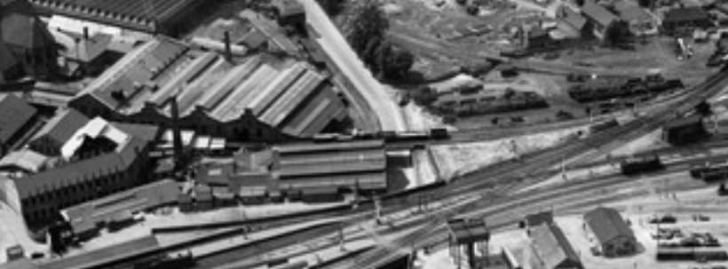
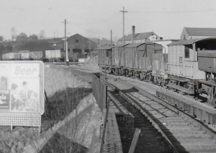
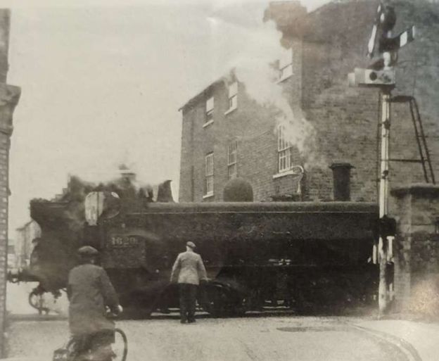
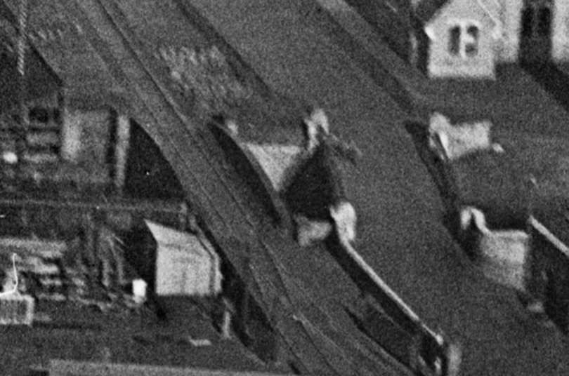
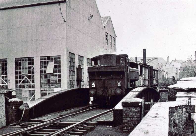
Vickers tells us that, “As the time for the daily (weekdays except Saturdays) trip approache[d], a shunter walk[ed] down from Shrub Hill Station, unfasten[ed] the padlocks, and open[ed] the gates at each side of the crossing over Shrub Hill. These protect[ed] the railway track when closed, but [did] not project onto the roadway when opened. When the engine with its train dr[ew] up to a signal protecting a catch point about fifty yards away from the road, the shunter pull[ed] on the road semaphores, which [were] of standard main-line pattern and operated from their posts, and, at a small ground frame beside the track. While the train close[d] the catch point and pull[ed] off the signal protecting it [and ran] slowly down the incline towards the road the shunter flag[ged] the traffic along Shrub Hill to a stand still, and when he ha[d] achieved this he signal[led] to the train to cross. Then, after allowing the road traffic to proceed, the shunter return[ed] the signals to their original position. He then walk[ed] down the track, across a bascule lift bridge, and over a canal bridge, on which the train ha[d] stopped.” [1: p236]

Western Region 0-6-0 pannier-tank engine on the ungated level crossing at Shrub Hill, Worcester, showing the semaphore signals to warn road traffic, © A.A. Vickers. [1: p236]
The same location in the 21st century. The hotel on the left is still in use. The building on the horizon on the left of the road was once part of the Vulcan Iron Works which was on the North side of the line. The road leaving the right of this image sits on the line of the old railway. [Google Streetview, July 2025]
The line then ran at high level towards and then over the Worcester & Birmingham Canal. Before reaching the canal crossed one of the accesses to the Vulcan Iron Works by means of a Bascule bridge! Once over the canal the line crossed Padmore Street and Pheasant Street before entering the site of Worcester Vinegar Works. This is an extract from the 25″ OS mapping of 1926, published in 1928, © Crown Copyright. [3]
The same location in the 21st century. The building running alongside the canal in this image (centre-top) was the Midland Red Bus Depot on Padmore Street. [4]
The bascule lift bridge which in 1959 was no longer operated. It carried the railway over one of the entrances to the Vulcan Iron Works, © A.A. Vickers. [1: p237]

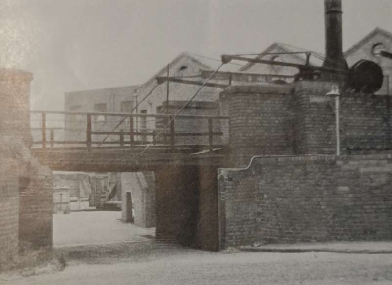
Vickers continues: “The bascule bridge [was] at a factory gate. and the headroom below it [was] about 6 ft. 6 in. [By 1959], only private cars and foot and cycle traffic [used] this entrance. The bridge was last operated many years [before], and one of the basic movements at its fulcrum [had, in 1955,] been immobilised by a concrete wedge which [bore] the date 6th February 1955. The span [was] partly counterweighted, but required a chain and capstan haulage to raise it. The fulcrum contained a complicated arrangement to allow sufficient free space for movement at rail level to occur. First a padlock was unfastened to free a pivoted sleeper which blocked rotation of the fulcrum of a small 18 in. length of rail which was in effect a subsidiary bascule section. When this was raised there was thus an 18 in. gap which allowed the fulcrum of the main span to roll back as the span was raised. The free end of the subsidiary and main span was in each case allowed to slide into an open fish-plate end, the bottom bulge of the rail section having been cut away flush at the end of the span for this purpose. At the main span end the junction [was] fixed by insertion of the fish-bolts.” [1: p236-237]

This photograph shows a very similar view to that on the monochrome image above. The bascule bridge is long gone but the Vulcan Iron Works buildings on the right remain in 2016. [Google Streetview, July 2016]
The bascule bridge as it appeared in an East facing aerial image from 1921. Image no. EPW005415, © Historic England. [7]
The rail bridge and Cromwell Street bridge over the Birmingham & Worcester Canal as seen in another extract from the 1922 aerial image. Image no. EPW005415, © Historic England. [7]
The railway bridge over the Canal again, © Unknown. [9]

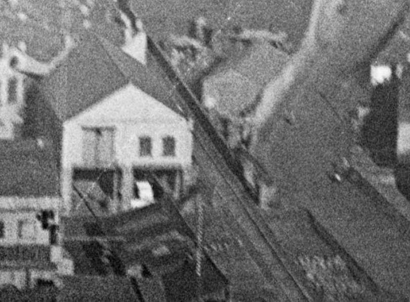
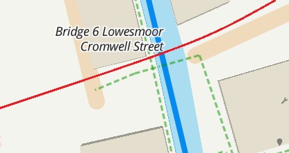
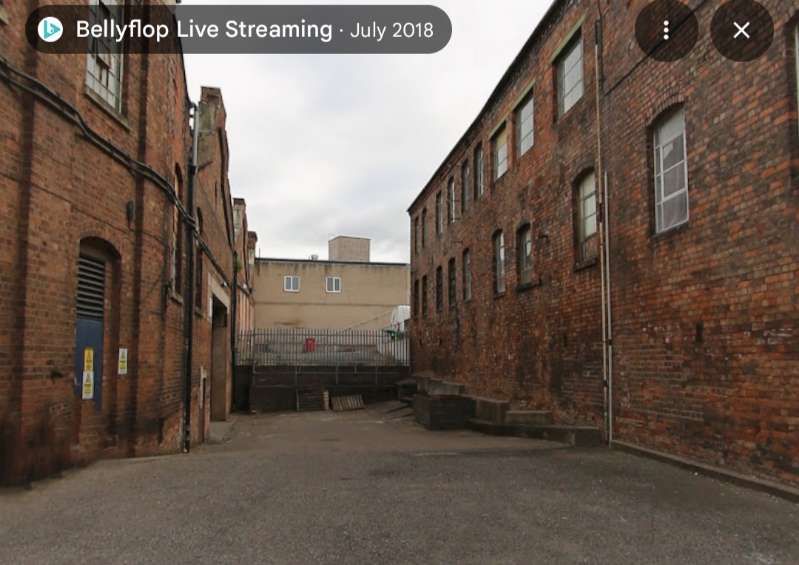
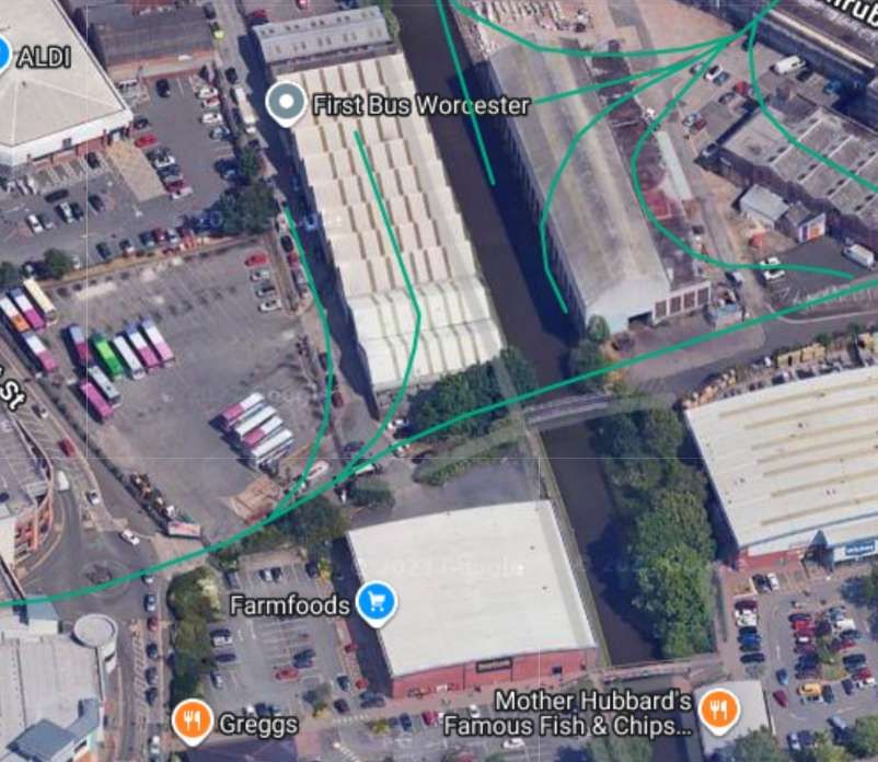
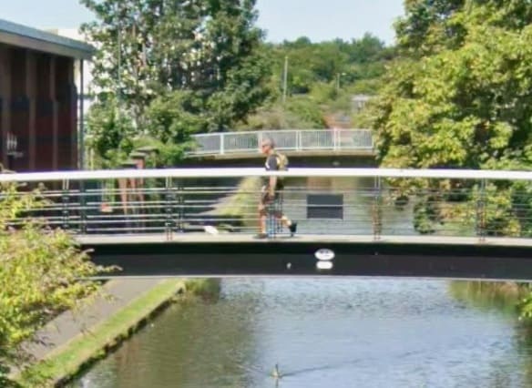
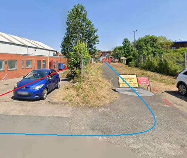
Adjacent to the railway bridge over the canal there was a road bridge carrying Cromwell Street which by 1959 was unsafe for vehicular use. The red line denotes the route of the branch. The road bridge was replaced by a footbridge. [5]

The view North from George Street, Worcester along the Birmingham & Worcester Canal. The bridge furthest from the camera is the footbridge that replaced Cromwell Road Bridge. The railway bridge beyond it was removed some time ago. [Google Streetview, July 2025]

The level-crossing to the immediate West of the canal only crossed a road of very minor importance (Padmore Street), leading only to a private car park and yard.

The corner of Padmore Street and Cromwell Street in 2025. The blue line shows what was once a through road over the canal. Work was being undertaken on the pedestrian bridge over the canal in July 2025. The red line on the image is the line of the old railway. The building at the left was the Midland Red Bus Depot on Padmore Street. In the 21st century it is the depot for First Bus. [Google Streetview, July 2025]

While the shunter [was] opening the crossing gate, the engine [was] uncoupled from the train. To allow for this the train, which usually consist[ed] of about eight wagons, [was] marshalled with a brake van at each end. The brakes of the leading van [were] applied and the engine [ran] forwards onto a short spur, on which [was] the remainder of a trailing point which once gave access to a factory on the site [which is 1959 was] occupied by the Midland Red Omnibus Company’s depot. The point leading to this spur [was] sprung to act as a catch point protecting the third level crossing, at Pheasant Street, which is the lowest point on the line.” [1: p237]

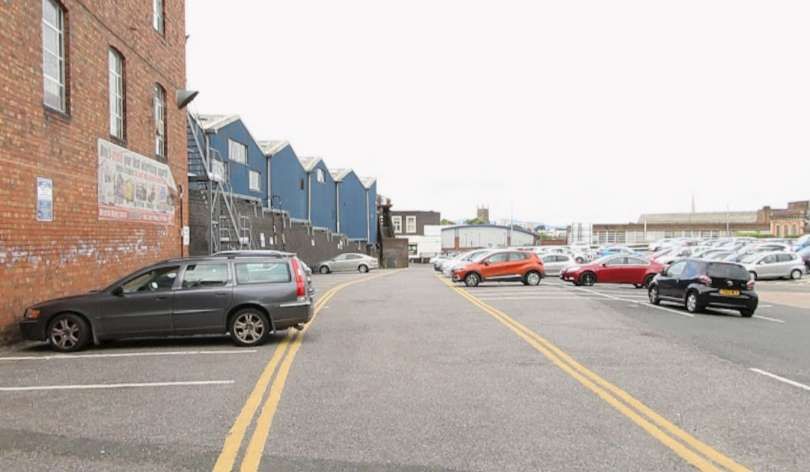
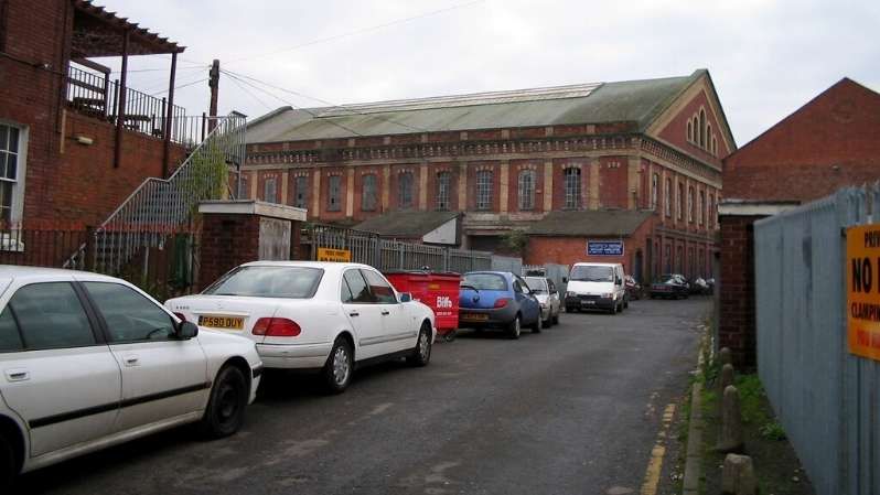
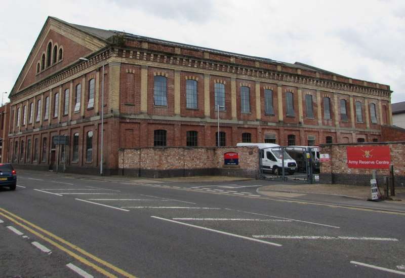
The Midland Red Depot was once the site of City Flour Mills. The site was later redeveloped and used by McKenzie, Clunes & Holland, renamed McKenzie & Holland from 1875, then McKenzie & Holland Limited from 1901, for the manufacturing of railway signalling equipment. Worcester operations of that company closed in 1921. A number of railway branch-lines were used to access the site. The site was acquired in 1927 by the Birmingham and Midland Motor Omnibus Company Limited (BMMO—Midland “Red” Motor Services) in preparation for the expansion required to operate the new Worcester City local bus area network due to start the following year. The purchase included an eight-bay, steel-framed corrugated-iron factory sited between the canal and Padmore Street which was converted for use as a bus depot, and part of former railway sidings from the Vinegar Works branch line to be used for outdoor parking. Work to convert the building included removing the wall that faced onto Padmore Street and replacing it with a series of sliding doors to allow vehicle access. ‘MIDLAND “RED” MOTOR SERVICES.’ was painted in large letters above the doors. The new depot opened on 1st June 1928. The garage was extended in 1930 with the addition of two extra bays built over the former railway sidings at the south end of the main building. The new bays were notably wider and, unlike the original building, could accommodate full-height enclosed double-deck buses. [11]

Worcester Vinegar Works in 1926, © Crown Copyright. [3]
The site of the Vinegar Works in the 21st century. Major retail development has occurred on the site. The green lines represent the sidings which once served the Vinegar Works. [4]
Worcester Vinegar Works seen from the air in 1921. Note the large warehouse at the centre of the photograph. Image no. EPW005415, © Historic England. [7]

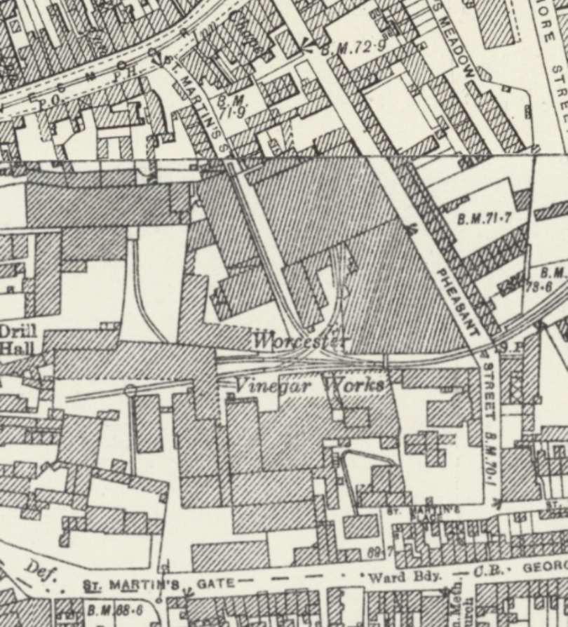
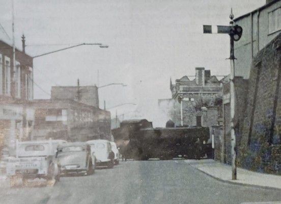
Pheasant Street had a gated crossing, while the locomotive and its short train were negotiating the crossing on Padmore Street, “a shunter from Hill, Evans & Company, for the benefit of whose vinegar factory the whole operation[was] carried out, … unfastened the padlocks and opened the gates at Pheasant Street level crossing.” [1: p237]

Another photograph of an 0-6-0PT, this time crossing Pheasant Street in 1959. Note the unusual signals referred to in the text,© A.A. Vickers. [1: p238]
Looking North along Pheasant Street in the 21st century. The old branch line crossed the road just to the North of the traffic island. The building on the left is part of the large ASDA which sits on the site of the old Vinegar Works. Further North on the West side of Pheasant Street, the main warehouse for the Vinegar Works remains standing. [Google Streetview, July 2025]
Standing at a location close to the roundabout but on the East side of Pheasant Street in 2006, this image centres on the Vinegar Works warehouse. The building on the right has gone and those on the left have been replaced by the ASDA store, © Sandy Gerrard and licenced for reuse under a Creative Commons licence (CC BY-SA 2.0). [8]
Another view in 2017 of what was the warehouse for the Vinegar Works. The ASDA store building just encroaches on the left of this image, © Jaggery and licenced for reuse under a Creative Commons licence (CC BY-SA 2.0). [8]

At the Pheasant Street level-crossing, the signals were on one post. small somersault arms control road traffic, with central spectacles, and coupled together directly so that one inclines in the wrong direction when ‘off’. They are provided with a central lamp. “When both shunters [were] satisfied that road traffic at the second and third crossings [was] responding to their flags, the guard in the leading brake van release[d] his brakes and allow[ed] the train to run forward down the slope. … The approach to Pheasant Street [was] quite blind, and the train appear[ed] through the gap in the high walls at the side of the road without audible warning at some 20 m.p.h., and [was] gone as quickly through the gap on the other side of the road. The engine follow[ed] at its leisure, to do any necessary shunting before pulling a train back up to Shrub Hill.” [1: p238]

Hill, Evans & Co was founded in the centre of Worcester in 1830 by two chemists, William Hill and Edward Evans. The pair started producing vinegar, but later the company also produced: wines from raisin, gooseberry, orange, cherry, cowslip, elderberry; ginger beer; fortified wines including port and sherry; as well as Robert Waters branded original quinine which was drunk to combat malaria.” [6]
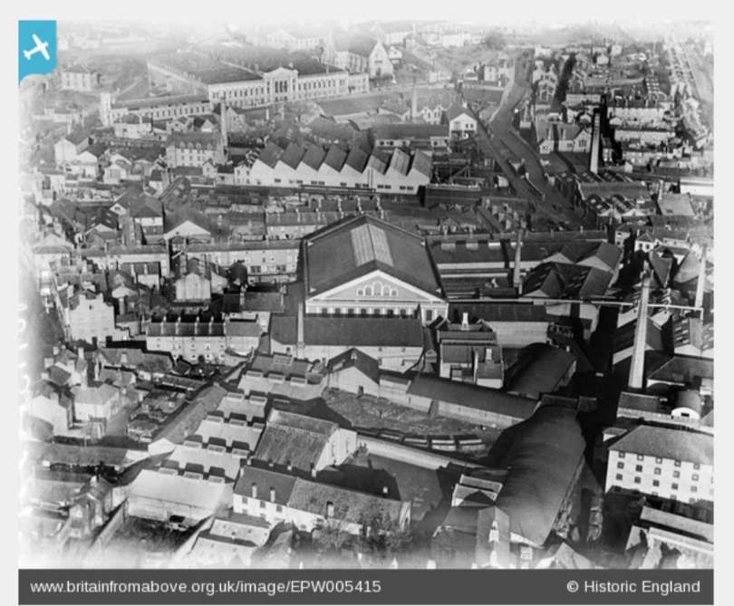
As the company quickly expanded, they purchased a 6 acres (2.4 ha) site at Lowesmoor. In 1850 the company built the Great Filling Hall, containing the world’s largest vat, which at 12 metres (39 ft) high could hold 521,287 litres (114,667 imp gal; 137,709 US gal) of liquid.  For a century this made the works the biggest vinegar works in the world, capable of producing 9,000,000 litres … of malt vinegar every year.” [6]

Movement of wagons within the factory [was] carried out by a small road tractor equipped with a cast-iron buffer beam and a hook for towing with the aid of a rope. For this reason the rails in the factory [were] mostly laid in tramway fashion, flush with the surface.” [1: p238]

One of the provisions of the Worcester Railways Act of 1870, under which the line was built, was that signals must be provided at the public crossings to warn the public when trains required to cross the speed of the latter was also to be limited to 4 m.p.h. A few years ago a Land-Rover was in collision with a train on Shrub Hill Road level crossing. It is understood that legal opinion of the question of liability was sought, and was to the effect that the semaphore signals fulfilled the obligations of the railway to give adequate warning of the approach of a train, and that the attend-ance of a shunter with red flags was unnecessary. Be that as it may, road traffic pays no heed to the semaphores, being mostly unaware of their significance.

References

  1. A.A. Vickers; An Unusual Branch at Worcester; in The Railway Magazine, April 1959; London, 1958, p236-238.
  2. https://maps.nls.uk/view/120900868, accessed on 7th November 2025.
  3. https://maps.nls.uk/view/120900904, accessed on 7th November 2025.
  4. https://railmaponline.com/UKIEMap.php, accessed on 7th November 2025.
  5. https://explore.opencanalmap.uk/canal/worcester-and-birmingham-canal/#7.3/53.952/-2.258, accessed on 8th November 2025.
  6. https://en.wikipedia.org/wiki/Hill,Evans%26_Co, accessed on 8th November 2025.
  7. https://www.britainfromabove.org.uk/en/image/EPW005415?check_logged_in=1, accessed on 8th November 2025.
  8. https://www.geograph.org.uk/stuff/list.php?title=Old+Vinegar+Works+&gridref=SO8555, accessed on 8th November 2025.
  9. https://www.cfow.org.uk/picture.php?/1197/categories, accessed on 8th November 2025.
  10. https://www.worcesternews.co.uk/resources/images/17365723/?type=responsive-gallery-fullscreen, accessed on 8th November 2025.
  11. https://www.midlandred.net/depots/index.php?depot=wr, accessed on 10th November 2025.
  12. https://www.britainfromabove.org.uk/en/image/EPW044990, accessed on 10th November 2025.
  13. https://www.britainfromabove.org.uk/en/image/EPW044987, accessed on 19th November 2025.

A Lickey Light Railway – Modern Tramway Vol. 13 No. 146

The mention of ‘Lickey’ in the railway press usually conjures up thoughts of the Lickey Incline and the bankers needed to enable steam-powered trains to make the climb.

In an article written in 1949 (Modern Tramway’s Prize Article of 1949) and published in February 1950, B.J. Pridmore prophetically proposed a Light Rail solution to anticipated traffic issues on the transport corridor centred on the Bristol Road.

Would cities in the UK which already had some reserved tram tracks have benefitted from forward thinking that sustained the use of trams through the latter years of the 20th century on tracks and routes which would be suitable for the current wave of Light Rapid Transit/Modern Tramway provision?

A schematic representation of the tramways in the centre of Birmingham in 1930, © Voogd075 and licenced for use here under a Creative Commons Licence (CC BY-SA 3.0).  [4]
The line from Birmingham to Rednal and Rubery, © Voogd075 and licenced for use here under a Creative Commons Licence (CC BY-SA 3.0). [4]

Here is Pridmore’s article in full (illustrations are from a variety of referenced sources):

Summary

There are few cities with a passenger transport route so convenient for conversion to a rapid-transit light railway as is the Birmingham route to the Lickey Hills. In this article is submitted a scheme for such a conversion, describing the route, the alterations required to the track and vehicles, the attractive services which could be operated, and the possibility, in the future, of the possession by Birmingham of a true rapid-transit installation giving a public passenger transport system freed from the delays due to street congestion.

Introduction

The Lickey route of the Birmingham tramways extends about eight miles Southwest of the city, connecting it to the suburb of Edgbaston (2 miles) and the almost separate entities of Selly Oak (4 miles), Northfields (6 miles) and Longbridge (7 miles and location of the Austin Works), bifurcation at this point giving two termini at the dormitory villages of Rednal and Rubery on the edge of the Lickey Hills.

The traffic on this route is partly of a business character, with a morning peak to the city, two small mid-day peaks, outward and inward, from the city to Selly Oak, and the evening peak of outward-bound traffic. Superimposed upon this are the industrial peaks, of a general nature to and from the city, and of a concentrated nature in the opposite directions to and from the Austin Works at Longbridge. Further traffic is of an interurban nature: between each of the shopping centres of Northfields and Selly Oak as well as from each of these to Birmingham there is appreciable miscellaneous traffic. There is also considerable holiday traffic to the Lickey Hills on non-working days.

Services are operated from the city to Rubery and Rednal, with many short workings to Selly Oak, and extra mid-day journeys from Longbridge to Northfields and Selly Oak, whilst services on the inner (and suburban) section of the route are amplified by the superposition of those to and from Pershore Road (Cotteridge). which share the Bristol Road with the Lickey routes for the first two miles or so to the junction at Pebble Mill Road.

This trunk route with large and varied traffic and high load factor has already about three-quarters of its length constructed as reserved track. Much of this has recently been relaid “solid” on a concrete foundation, instead of on the ballasted sleepers as originally.

It has only two short gradients of any magnitude, and would thus seem ideal for gradual conversion towards an interurban light railway giving ample capacity on the route and removing public transport from the road proper, hence also reducing congestion in the bigger Birmingham of tomorrow for it is along this route that Birmingham seems ripe for the next phase of expansion.

In the remainder of this article it is suggested how, ultimately, this route should be converted to a light railway as a contribution towards ideal transport in the greater Birmingham of the future.

The Track and the Route

The present Navigation Street terminus loop should be improved to give loading islands outside two parallel tracks at the terminal loading point; the track layout should include crossovers to enable Pershore Road cars to be separated from Lickey cars, and Selly Oak and other short working cars to be separated from through cars (as will be needed for peak-hour services, q.v.). The one-way streets forming the loop are amply wide enough to permit the tram tracks to be relocated at the sides and be totally reserved; public transport would thus be segregated from the rest in this most congested section of the route.

Tram No. 842 sits at the Navigation Street terminus of the route from Birmingham to Rednal and Rubery. [3]
The Navigation Street terminus of the tram service to and from the Lickey Hills. Tram services No. 70 and No. 71 circulated round the loop shown on this extract from the 25″ Ordnance Survey of 1913 (published in 1918). [6]

The Bristol Road as far as Pebble Mill Road will ultimately have to be widened if traffic increases much more; but taking in part of the footways and front gardens would in general give room for the central eighteen feet of reservation which would suffice for the tramway. Alternatively, the reservation could be at the side and a three-lane road be left for the remainder of the traffic. As an interim measure local road-widening and the provision of loading islands with queue barriers, the former combined with pedestrian crossings, at the few important stops, should be undertaken.

The narrow road through Selly Oak and under the railway bridge presents the greatest obstacle; track reservation should be made when this is widened, while the provision of loading islands would seem the only present practicable measure.

The roads through Northfields and Longbridge are amply wide enough for a narrow track reservation (lacking the wide grass borders of the present reservations) and conversion of these sections to dual carriageway with central reservation for the tramway should be done as soon as the conversion scheme is commenced.

The tracks at present reserved can remain as now except that it would be wise to convert the remainder of the sleeper track to ‘solid’ track before high-speed running is commenced.

The Cars

Pending the acquisition of new cars (possibly like those at Llandudno, which show what can be done on 3ft. 6in. gauge if the spirit is willing), conversion of about 20 cars of the ‘800’ class for the base service and its reserves, and rehabilitation of another forty air-braked cars, would enable the Department to put the scheme into operation with the minimum of delay.

The cars to be converted should have their roofs and ends removed and the body sides made straight (instead of waisted). The roofs and ends should be renewed and the cars at the same time lengthened about two feet each end. The new ends and roofs should be on the lines of those of the post war Glasgow cars: platform doors should be added and the stairhead doors and bulkheads omitted. Large destination and route number blinds should be fitted below the top-deck windows. Interior decoration should be as modern and attractive as in any other vehicle of early 1950s – brown ceilings are out of place to-day.

To reduce noise the short coil springs on the bogies might be replaced by rubber pads. The long coil springs should be shortened and stiffened (to reduce noise) and have rubber pads above them, again to reduce noise. The motor gear ratio should be decreased by about 10 per cent and helical gears fitted. Automatic but optional field shunting, giving 66 per cent of normal field, should be added. This should give free-running speed of up to 35 m.p.h., yet, by reason of the large amount of free-running possible on such a route, should not unduly stress the motors thermally. The present controllers would suffice for the more arduous duty if a lineswitch contactor were added to perform circuit breaking; the cost and complexity of contactor control would not, in such a conversion, be justified. The present brake installation could be retained if rubber bushed joints were used in the rigging to reduce noise.

The cars to be rehabilitated should be given straight sides, new roofs, rubber rods in the springing, automatic optional weak field, and lineswitch circuit breakers. These alterations would render them comparable in appearance and performance with No. 843, which in good condition, is still an advertisement for 3ft. 6in. gauge possibilities.” [1: p37-38]

Close to Longbridge Railway Station and Longbridge Works the two tram services down Bristol Road (No. 70 & No. 71) separated. One turning to the West along the A38 (to Rubery), the other continuing along the B4120 to Rednal. [8]
The tram is turning left to follow the A38 into Birmingham having travelled from Rubery along the A38. The road ahead on the left side of this photograph is Lickey Road which heads towards Rednal, © D.J. Norton and used with the kind permission of his son (donation made to Asthma UK). [5]
The Rubery tram terminus was closed to the Rubery Mental Hospital which sat just to the North of the A38. The central reservation of the Bristol Road widened to give space for the terminus. [8]
Tram No. 759 at the Rubery terminus in 1952, © D.J. Norton and used with the  kind permission of his son (donation made to Asthma UK). [5]
The Rednal tramway terminus is a loop which straddles the join between two 25″ Ordnance Survey map sheets, that which cover the Longbridge Works and the sheet to the South. This is the element of the terminus which sits at the top of the more southerly OS map sheet. [9]
Tram No. 777 at the Rednal terminus in 1952, © D.J. Norton and used with the  kind permission of his son (donation made to Asthma UK). [5]
Tram No. 843 sitting at the Rednal terminus, © Public Domain. [2]

Pridmore continues:

“The Stops

These should be spaced as widely as possible, on the theory of ‘greatest good for greatest number’, even if the short-distance passenger suffers during peak hours. It is more important that the many living in Selly Oak and beyond should have a fast journey home than that an Edgbaston passenger should be set down at the end of his turning. There should be three stops only between Navigation Street and Pebble Mill Road, located where they will be of most use to peak-hour passengers. These stops should have loading islands and queue barriers as described earlier. Other stops, convenient for short distance passengers, clearly labelled ‘not used in peak hours’,  should be provided to attract the extra revenue, so useful to any undertaking, which accrues from the casual off peak travel which is a consequence of an attractive service being available.

Beyond Pebble Mill Road, peak-hour stops at each outskirts and the centre of Selly Oak, Northfields, and Longbridge, should be the main points for loading and unloading; there should be some additional stops between these centres at places where the need is obviously great. None of these additional stops should be separated by less than a quarter of a mile, however, but additional stops ‘not used in peak hours’ should also be provided where considered appropriate.” [1: p38-39]

The junction of Pebble Mill Road and Bristol Road, Birmingham as shown on the 25″ Ordnance Survey  of 1939 which was published in 1945. [7]
Looking Southwest along Bristol Road through its junction with Pebble Mill Road. The trams for The Lickey Hills stopped just beyond the junction. Pebble Mill Road central reservation was at times used to store trams and particularly after the closure of the network before there was room for them at the Depot. [Google Streetview, June 2024]

Pridmore continues:

Services

A base frequency of 12 cars per hour from Navigation Street, half of which would run to Selly Oak only, would probably suffice. Pershore Road should be symmetrically superimposed. The equal service to

During peak hours, however, a different technique would facilitate traffic flow and give quick travel to long-distance passengers; it is suggested that 12 packets of departures per hour be arranged. The first of each packet would be a fast to Rednal or Rubery, running non-stop to Pebble Mill Road. The second would be a duplicate of the first, but routed to the alternative terminus, stopping only at the peak hour stops to Pebble Mill Road to pick up only. Thence both these cars, would continue, using peak hour stops only (as is presumed in all peak hour services), to their respective termini. The third car would be the triplicate, running as the duplicate but probably to Selly Oak, Northfields or Longbridge only, as the traffic for the extremities of route dictates. Fourth would be the Pershore Road car, stopping also to set down at intermediate points to Pebble Mill Road, and fifth would be its duplicate performing similar duties as necessary.

If a less or more frequent service should prove necessary its pattern should be similar to that indicated above, as the suggested total frequency of 60 cars per hour is well within the capacity of a single line of tramway, whilst the use of packet departures will facilitate the through-running of the long-distance cars.

Inwards peak hour working, when with the load, would be arranged so that cars from Bristol Road would stop only to set down between Pebble Mill Road and Navigation Street, and that such cars should be given priority at the Pebble Mill Road junction.”

The necessity for large destination blinds on the cars, a point mentioned earlier, is now appreciated; the indication of “limited stop” must be given, as well as the destination, and regular users will wish clearly to be aware of both whilst a car approaches their stop.” [1: p39-40]

A P.C.C. tram at work in Cleveland, Ohio. Pridmore suggests trams of this type as being suitable in the longer term for his proposed Lickey (Bristol Road) Light Railway. The picture shows Tram No. 42 of the Shaker Heights Rapid Transit in Cleveland at Shaker Square in the 1960s. No. 42 is running in multiple unit (MU) mode with another Shaker Heights Rapid Transit P.C.C., © Robert Farkas. [10]

Again, Pridmore continues:

Future Development

The success of a scheme such as that described above would commend its application to the similar but not quite so heavily trafficked routes to Pype Hayes and Erdington on the east of Birmingham.

When the full conversion to reserved track had been completed in the less near future, consideration should be given to the provision of a third track to Pebble Mill Road to permit the regular operation of peak hour expresses both ways, and for the ultimate operation of two or three-car trains of single deck high-speed vehicles much as the P.C.C. cars on metre gauge lines in the U.S.A. and elsewhere.

The use of such trains would then render possible the economic construction of cross-town subways in further effort to remove passenger transport from the sorely congested central streets of Birmingham.

The transport problem of Birmingham, as of many large cities, is becoming increasingly severe. The author is of the opinion that such problems can only be solved by the provision of an urban transport installation, and not by the use of supposedly flexible vehicles on the existing network of roads; it is the attempt to solve the problem by this latter means that is responsible for the congestion in the centre of Birmingham at the present time. An embryo specialised installation exists in Birmingham to-day; it is recommended that it be developed as far as possible for its specialist purpose while there is still time and before the traffic of the future swamps the Bristol Road completely, as it will do if numberless small vehicles are expected to cope with it in competition with the many others who regard themselves as having equal claim to the surface of a public road.” [1: p40]

References

  1. B. I. Pridmore; A Lickey Light Railway; in Modern Tramway Vol. 13 No. 146, London, p37-40.
  2. https://www.birminghamforum.co.uk/index.php?topic=710.9, accessed on 10th January 2025.
  3. https://www.birminghamforum.co.uk/index.php?topic=710.99, accessed on 10th January 2025.
  4. https://en.m.wikipedia.org/wiki/Birmingham_Corporation_Tramways#/media/File%3ABirmingham-1930.png, accessed on 10th January 2025.
  5. http://www.photobydjnorton.com/TramsBristolRoad.html, accessed on 10th January 2025.
  6. https://maps.nls.uk/view/115633314, accessed on 10th January 2025.
  7. https://maps.nls.uk/view/115633266, accessed on 10th January 2025.
  8. https://maps.nls.uk/view/120223278, accessed on 10th January 2025.
  9. https://maps.nls.uk/view/120899500, accessed on 10th January 2025.
  10. https://akronrrclub.wordpress.com/tag/shaker-heights-rapid-transit-lines, accessed on 2nd January 2025.