
The Leckhampton Quarries …
In this addendum to the previous four articles about the Gloucester and Cheltenham Tramroad we return to the head of the line and to the quarries on Leckhampton Hill.
While on holiday in the Forest of Dean in September 2021, I picked up a secondhand copy of “Gloucestershire Railways in the Twenties” by Humphrey Household. [1] It consists of a review of the development of the railways in Gloucestershire supported by a series of photographs which were predominantly taken in the 1920s by Humphrey Household. The photos are a significant resource. The text of the book is well-written. Its final two chapters were of real interest to me.
The chapters are entitled “Leckhampton Quarries” and “The Forest of Dean.” The second of these two chapters warrants discussion elsewhere. The first provides some significant additional material relating to the Tramroad (or should it be called a tramway?) and some important and delightful pictures showing the quarries, their transport links and construction work in the 1920s.
Interestingly, Household highlights the way in which Cheltenham’s street layout has been significantly influenced by the presence of the tramway. He points to the shape or alignment of “Queen’s Road from Lansdown, where the branch left the Gloucester-Cheltenham tramway line close to the Midland Railway station; the triangular Westall Green in Tivoli, so shaped to accommodate sidings and a depot; the narrow Norwood Street running at a curious angle to meet the Leckhampton Road; a length of sunken pavement on the west side of that road which had been a shallow cutting to ease the gradient; the yard at the foot of the hill where caravans were later built.” (p95-96)
Accompanying the text are a series of photographs taken in both 1911 and 1923 and show the tramway at work. It is clear from the pictures that by 1923 the condition of the tramway was deteriorating and was no longer in constant use. Household comments: “from my very early years the tramways were an unceasing source of interest. From the upper windows of a house in The Park, I could see Top Incline, and the rare occasions when I spotted it in use caused considerable excitement! Bottom Incline was secluded in a privacy jealously preserved … But the steep public footpath alongside the … Middle Incline was one we often used; it emerged amid the junctions on the rough plateau whence Top Incline ascended with awe-inspiring abruptness.” (p97)
Household goes on to express his delight as a young boy when invited, on occasional weekday visits, by a friendly quarryman to ride in a wagon of a horse-drawn train. And once even to being allowed to ride up the incline! An early case of ‘joy-riding’, says Household.
In this chapter, Household provides a relatively detailed description of the operation of the line and each of the inclines. The 1911 photographs were taken by his father, those of 1923, by Household himself.
Household reflects on the fact that by 1923 the tramway had reached very much the end of its value to the quarries. This happened because in the closing months of 1922, a new standard-gauge railway line was constructed. His keen interest in railway matters led to him photographing extensively the progress of the work. His records show that ,”during the two years before the railway and its associated works were finished, [he] took well over a hundred photographs. … Fortunately [he] recorded details on the leaves of the album when [he] mounted the pictures.” (p101)
The new works were prompted by the formation of a new company “to exploit the resources of Leckhampton Hill, primarily in the production of lime, and a prospectus issued in July 1922 enthusiastically stressed the great quantity of stone that was easily accessible and the substantial profit expected to accrue from large scale extraction.” (p101-102)
A single photograph is reproduced below.It was taken in 1924 and illustrates the magnitude of the change which took place in the early 1920s.
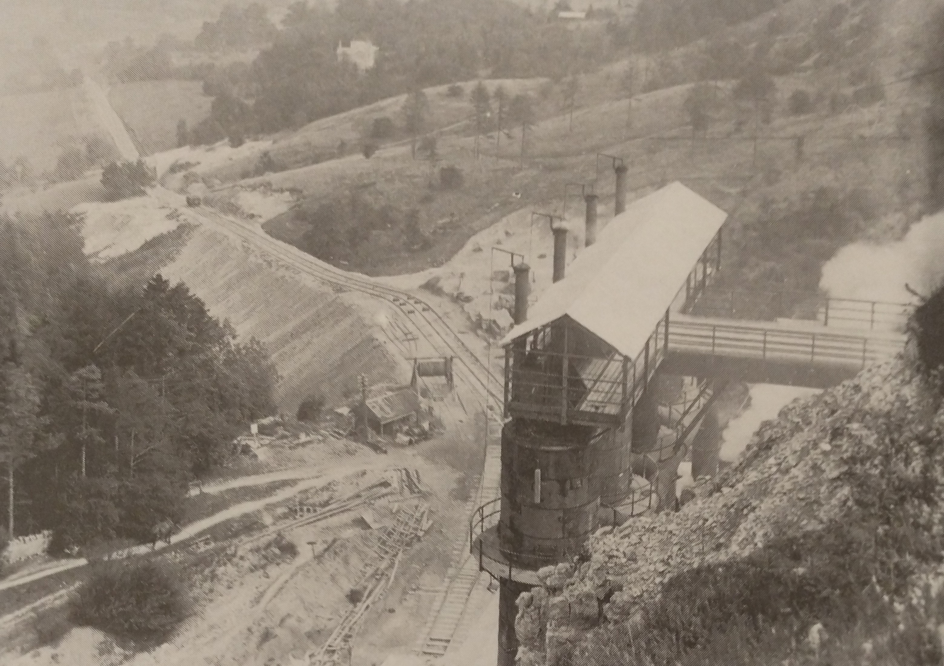
“Leckhampton Hill: the lime kilns and the standard gauge railway built 1922-1924. Almost the whole course of the line can be traced in this photograph: the incline, the bridge carrying Daisy Bank Road, the passing loop, the incline foot, the track curving from it past Southfield Farm to the level crossing of Sandy Lane (whose white gate posts are just visible between two groups of treetops), the grey line of cutting stretching almost to Charlton Kings GWR station. To the left of the kilns are the winding drum used to lower tip wagons while the embankment was being built, and the shed covering the machinery at the head of the old tramway’s Middle Incline.” (p102)
Household goes on to say that
“The steepness of the ascent from the Leckhampton Road, and the impossibility of making connection with the main railways through the built up area of the town, meant that an entirely new route had to be found, and the promoters decided on a line some one-and-a-quarter miles long descending to the Great Western’s Banbury & Cheltenham Railway at Charlton Kings, part of which was to be a cable-worked incline two-thirds of a mile in length to overcome a fall of nearly 400 feet.” (p102)
Household provides details of the kind of contractor’s wagons used on the project and details of the process of building the necessary embankment for the new line, complemented by his own photographs. The contractors were Caffin & Co. of London and they made extensive use of manual labour supported by a government loan to the project to support local employment.
The construction of the embankment took the best part of a year! While this work was progressing slowly a cutting was being excavated between Sandy Lane and Charlton Kings GWR station. Household provides pictures of the Ruston steam navy at work and of the contractor’s locomotive, 0-6-0ST Fashoda, built by Manning Wardle & Co. of Leeds in 1898. He also provides a detailed commentary on the works as they progressed. Fascinating photographs back up the text of the chapter.
As part of the work, “A footbridge had to be built for a field path close to the junction at Charlton Kings, and an overbridge to carry Daisy Bank Road across the track just over half way up. Both were formed of steel girders between abutments of neat stone walling.” (p110)
It may also be of interest to note that the new incline was not to be a simple self-acting incline. Power was required, “supplied by an eighty horse-power electric motor geared to the winding drum, and electricity was generated by a plant installed at Southfield Farm. Here,” says Household, “there were duplicate sets, each consisting of a Sandycroft 440 volt, 262 ampere alternator driven by s four-cylinder Premier Gas Engine developing 250 to 300 horse-power, fed by a Crosslet suction gas plant. Transformers stepped up the voltage to 2,200 for transmission to the top of the hill where it was reduced before being distributed via the switchboard to the winding motor, the lighting circuits and the fans at the kilns.” (p114-116)
The new kilns, 4 in number, were 77ft tall and became dominant features on the hill. They were “supplied by Priest Furnaces and erected on a stone-revetted platform so that lime could be fed by gravity into railway wagons alongside, and the kilns themselves were also fed by gravity from narrow gauge tip-trucks run out across a bridge from the quarry gallery.” (p116)
A 0-4-0ST locomotive Lightmoor built by Peckett & Co. in 1902 was purchased by the company to work between the foot of the new incline and the sidings which had been constructed at Charlton Kings.
Household reports that, while blasting had long been practised in the quarries it had been on a small scale, the need both to produce construction stone and much smaller pieces for burning meant that blasting was vastly increased. He notes that, “thunderous reverberations disturbed the town and were particularly distressing to the well-to-do and influential inhabitants. … When to the annoyance there was added the danger of windows broken by concussion and flying fragments, complaints were voiced in the local press, an action committee was formed, and there was threat of an application for an injunction.” (p123)
In fact, the project was foundering anyway, profit projections had not been realised, the company was on the verge of bankruptcy. The national treasury appointed receivers and ultimately work ceased in November 1926, only a couple of years after completion of the incline, kilns and infrastructure.
The project had cost £270,000. At auction, in August 1927, only £8,000 was raised when material and plant was sold. Ultimately, the town council was able to buy the land at a very cheap price and the Hill became an open space available to all!
References
- Humphrey Household; Gloucestershire Railways in the Twenties; Alan Sutton Publishing Ltd., Gloucester, 1984 (reprinted 1986) …. the relevant chapters can be found from p93 onwards.

Pingback: Narrow Gauge Railways – Humphrey Household | Roger Farnworth
Absolutely fascinating series Roger. Thank you for your efforts and insights. I have recently discovered that I currently live in a converted coach house & stables that formed part of the Tram Way just south of the Horton Road crossing in Gloucester. I have discovered documentation that puts the conversion to dwelling at around 1876, a few years after the Tram Way was closed down. Your articles have added very interesting detail and local flavour to my research. Many thanks.
Thank you for your kind comments Iain.