The mention of ‘Lickey’ in the railway press usually conjures up thoughts of the Lickey Incline and the bankers needed to enable steam-powered trains to make the climb.
In an article written in 1949 (Modern Tramway’s Prize Article of 1949) and published in February 1950, B.J. Pridmore prophetically proposed a Light Rail solution to anticipated traffic issues on the transport corridor centred on the Bristol Road.
Would cities in the UK which already had some reserved tram tracks have benefitted from forward thinking that sustained the use of trams through the latter years of the 20th century on tracks and routes which would be suitable for the current wave of Light Rapid Transit/Modern Tramway provision?
Here is Pridmore’s article in full (illustrations are from a variety of referenced sources):
“Summary
There are few cities with a passenger transport route so convenient for conversion to a rapid-transit light railway as is the Birmingham route to the Lickey Hills. In this article is submitted a scheme for such a conversion, describing the route, the alterations required to the track and vehicles, the attractive services which could be operated, and the possibility, in the future, of the possession by Birmingham of a true rapid-transit installation giving a public passenger transport system freed from the delays due to street congestion.
Introduction
The Lickey route of the Birmingham tramways extends about eight miles Southwest of the city, connecting it to the suburb of Edgbaston (2 miles) and the almost separate entities of Selly Oak (4 miles), Northfields (6 miles) and Longbridge (7 miles and location of the Austin Works), bifurcation at this point giving two termini at the dormitory villages of Rednal and Rubery on the edge of the Lickey Hills.
The traffic on this route is partly of a business character, with a morning peak to the city, two small mid-day peaks, outward and inward, from the city to Selly Oak, and the evening peak of outward-bound traffic. Superimposed upon this are the industrial peaks, of a general nature to and from the city, and of a concentrated nature in the opposite directions to and from the Austin Works at Longbridge. Further traffic is of an interurban nature: between each of the shopping centres of Northfields and Selly Oak as well as from each of these to Birmingham there is appreciable miscellaneous traffic. There is also considerable holiday traffic to the Lickey Hills on non-working days.
Services are operated from the city to Rubery and Rednal, with many short workings to Selly Oak, and extra mid-day journeys from Longbridge to Northfields and Selly Oak, whilst services on the inner (and suburban) section of the route are amplified by the superposition of those to and from Pershore Road (Cotteridge). which share the Bristol Road with the Lickey routes for the first two miles or so to the junction at Pebble Mill Road.
This trunk route with large and varied traffic and high load factor has already about three-quarters of its length constructed as reserved track. Much of this has recently been relaid “solid” on a concrete foundation, instead of on the ballasted sleepers as originally.
It has only two short gradients of any magnitude, and would thus seem ideal for gradual conversion towards an interurban light railway giving ample capacity on the route and removing public transport from the road proper, hence also reducing congestion in the bigger Birmingham of tomorrow for it is along this route that Birmingham seems ripe for the next phase of expansion.
In the remainder of this article it is suggested how, ultimately, this route should be converted to a light railway as a contribution towards ideal transport in the greater Birmingham of the future.
The Track and the Route
The present Navigation Street terminus loop should be improved to give loading islands outside two parallel tracks at the terminal loading point; the track layout should include crossovers to enable Pershore Road cars to be separated from Lickey cars, and Selly Oak and other short working cars to be separated from through cars (as will be needed for peak-hour services, q.v.). The one-way streets forming the loop are amply wide enough to permit the tram tracks to be relocated at the sides and be totally reserved; public transport would thus be segregated from the rest in this most congested section of the route.
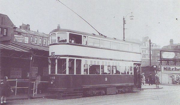
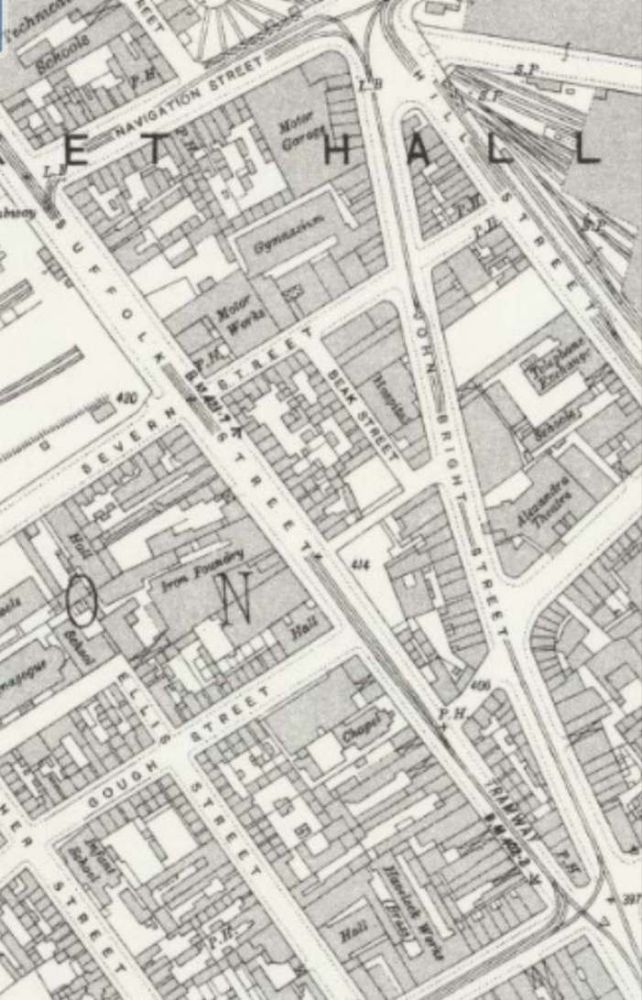
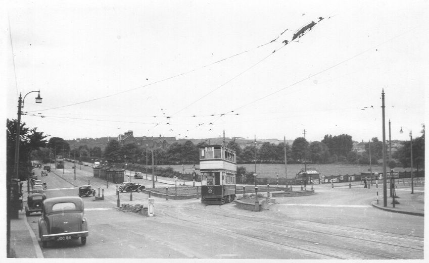
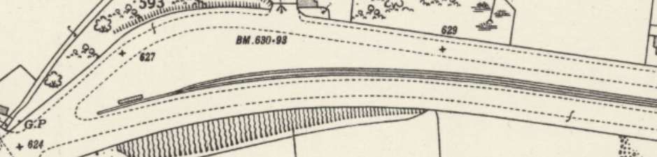
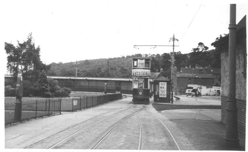
Tram No. 842 sits at the Navigation Street terminus of the route from Birmingham to Rednal and Rubery. [3]The Navigation Street terminus of the tram service to and from the Lickey Hills. Tram services No. 70 and No. 71 circulated round the loop shown on this extract from the 25″ Ordnance Survey of 1913 (published in 1918). [6]
The Bristol Road as far as Pebble Mill Road will ultimately have to be widened if traffic increases much more; but taking in part of the footways and front gardens would in general give room for the central eighteen feet of reservation which would suffice for the tramway. Alternatively, the reservation could be at the side and a three-lane road be left for the remainder of the traffic. As an interim measure local road-widening and the provision of loading islands with queue barriers, the former combined with pedestrian crossings, at the few important stops, should be undertaken.
The narrow road through Selly Oak and under the railway bridge presents the greatest obstacle; track reservation should be made when this is widened, while the provision of loading islands would seem the only present practicable measure.
The roads through Northfields and Longbridge are amply wide enough for a narrow track reservation (lacking the wide grass borders of the present reservations) and conversion of these sections to dual carriageway with central reservation for the tramway should be done as soon as the conversion scheme is commenced.
The tracks at present reserved can remain as now except that it would be wise to convert the remainder of the sleeper track to ‘solid’ track before high-speed running is commenced.
The Cars
Pending the acquisition of new cars (possibly like those at Llandudno, which show what can be done on 3ft. 6in. gauge if the spirit is willing), conversion of about 20 cars of the ‘800’ class for the base service and its reserves, and rehabilitation of another forty air-braked cars, would enable the Department to put the scheme into operation with the minimum of delay.
The cars to be converted should have their roofs and ends removed and the body sides made straight (instead of waisted). The roofs and ends should be renewed and the cars at the same time lengthened about two feet each end. The new ends and roofs should be on the lines of those of the post war Glasgow cars: platform doors should be added and the stairhead doors and bulkheads omitted. Large destination and route number blinds should be fitted below the top-deck windows. Interior decoration should be as modern and attractive as in any other vehicle of early 1950s – brown ceilings are out of place to-day.
To reduce noise the short coil springs on the bogies might be replaced by rubber pads. The long coil springs should be shortened and stiffened (to reduce noise) and have rubber pads above them, again to reduce noise. The motor gear ratio should be decreased by about 10 per cent and helical gears fitted. Automatic but optional field shunting, giving 66 per cent of normal field, should be added. This should give free-running speed of up to 35 m.p.h., yet, by reason of the large amount of free-running possible on such a route, should not unduly stress the motors thermally. The present controllers would suffice for the more arduous duty if a lineswitch contactor were added to perform circuit breaking; the cost and complexity of contactor control would not, in such a conversion, be justified. The present brake installation could be retained if rubber bushed joints were used in the rigging to reduce noise.
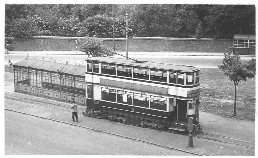
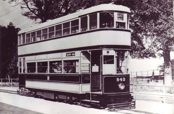
The cars to be rehabilitated should be given straight sides, new roofs, rubber rods in the springing, automatic optional weak field, and lineswitch circuit breakers. These alterations would render them comparable in appearance and performance with No. 843, which in good condition, is still an advertisement for 3ft. 6in. gauge possibilities.” [1: p37-38]
These should be spaced as widely as possible, on the theory of ‘greatest good for greatest number’, even if the short-distance passenger suffers during peak hours. It is more important that the many living in Selly Oak and beyond should have a fast journey home than that an Edgbaston passenger should be set down at the end of his turning. There should be three stops only between Navigation Street and Pebble Mill Road, located where they will be of most use to peak-hour passengers. These stops should have loading islands and queue barriers as described earlier. Other stops, convenient for short distance passengers, clearly labelled ‘not used in peak hours’, should be provided to attract the extra revenue, so useful to any undertaking, which accrues from the casual off peak travel which is a consequence of an attractive service being available.
Beyond Pebble Mill Road, peak-hour stops at each outskirts and the centre of Selly Oak, Northfields, and Longbridge, should be the main points for loading and unloading; there should be some additional stops between these centres at places where the need is obviously great. None of these additional stops should be separated by less than a quarter of a mile, however, but additional stops ‘not used in peak hours’ should also be provided where considered appropriate.” [1: p38-39]
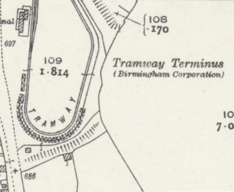
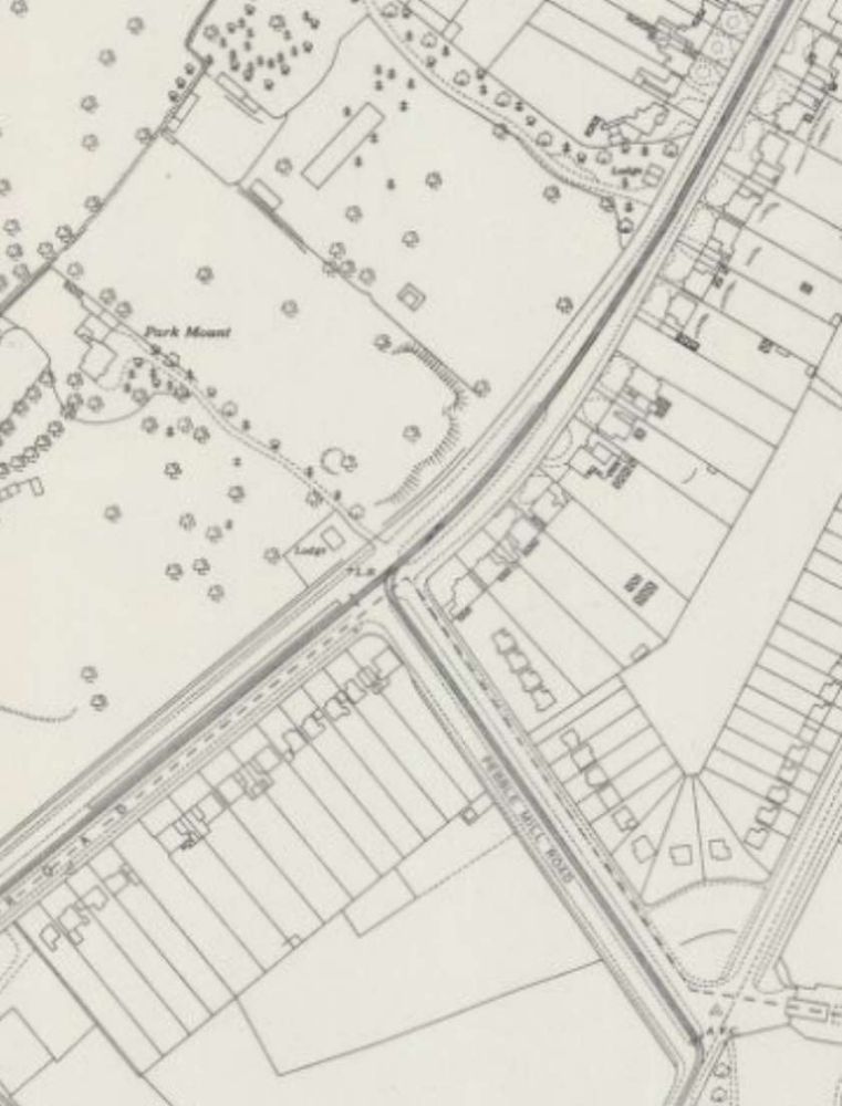
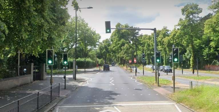
The junction of Pebble Mill Road and Bristol Road, Birmingham as shown on the 25″ Ordnance Survey of 1939 which was published in 1945. [7]Looking Southwest along Bristol Road through its junction with Pebble Mill Road. The trams for The Lickey Hills stopped just beyond the junction. Pebble Mill Road central reservation was at times used to store trams and particularly after the closure of the network before there was room for them at the Depot. [Google Streetview, June 2024]
Pridmore continues:
“Services
A base frequency of 12 cars per hour from Navigation Street, half of which would run to Selly Oak only, would probably suffice. Pershore Road should be symmetrically superimposed. The equal service to
During peak hours, however, a different technique would facilitate traffic flow and give quick travel to long-distance passengers; it is suggested that 12 packets of departures per hour be arranged. The first of each packet would be a fast to Rednal or Rubery, running non-stop to Pebble Mill Road. The second would be a duplicate of the first, but routed to the alternative terminus, stopping only at the peak hour stops to Pebble Mill Road to pick up only. Thence both these cars, would continue, using peak hour stops only (as is presumed in all peak hour services), to their respective termini. The third car would be the triplicate, running as the duplicate but probably to Selly Oak, Northfields or Longbridge only, as the traffic for the extremities of route dictates. Fourth would be the Pershore Road car, stopping also to set down at intermediate points to Pebble Mill Road, and fifth would be its duplicate performing similar duties as necessary.
If a less or more frequent service should prove necessary its pattern should be similar to that indicated above, as the suggested total frequency of 60 cars per hour is well within the capacity of a single line of tramway, whilst the use of packet departures will facilitate the through-running of the long-distance cars.
Inwards peak hour working, when with the load, would be arranged so that cars from Bristol Road would stop only to set down between Pebble Mill Road and Navigation Street, and that such cars should be given priority at the Pebble Mill Road junction.”
The necessity for large destination blinds on the cars, a point mentioned earlier, is now appreciated; the indication of “limited stop” must be given, as well as the destination, and regular users will wish clearly to be aware of both whilst a car approaches their stop.” [1: p39-40]
The success of a scheme such as that described above would commend its application to the similar but not quite so heavily trafficked routes to Pype Hayes and Erdington on the east of Birmingham.
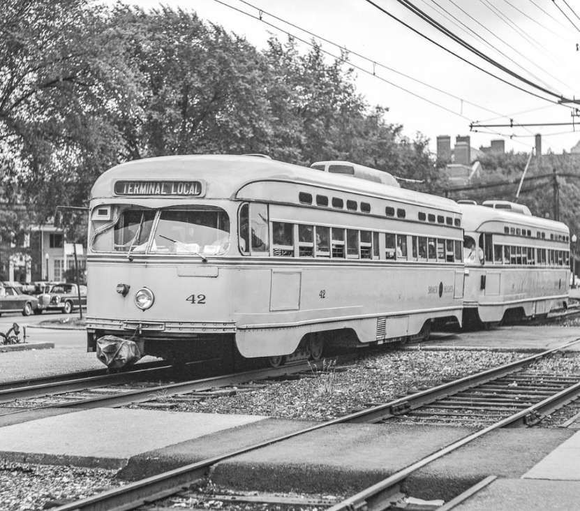
When the full conversion to reserved track had been completed in the less near future, consideration should be given to the provision of a third track to Pebble Mill Road to permit the regular operation of peak hour expresses both ways, and for the ultimate operation of two or three-car trains of single deck high-speed vehicles much as the P.C.C. cars on metre gauge lines in the U.S.A. and elsewhere.
The use of such trains would then render possible the economic construction of cross-town subways in further effort to remove passenger transport from the sorely congested central streets of Birmingham.
The transport problem of Birmingham, as of many large cities, is becoming increasingly severe. The author is of the opinion that such problems can only be solved by the provision of an urban transport installation, and not by the use of supposedly flexible vehicles on the existing network of roads; it is the attempt to solve the problem by this latter means that is responsible for the congestion in the centre of Birmingham at the present time. An embryo specialised installation exists in Birmingham to-day; it is recommended that it be developed as far as possible for its specialist purpose while there is still time and before the traffic of the future swamps the Bristol Road completely, as it will do if numberless small vehicles are expected to cope with it in competition with the many others who regard themselves as having equal claim to the surface of a public road.” [1: p40]
References
B. I. Pridmore; A Lickey Light Railway; in Modern Tramway Vol. 13 No. 146, London, p37-40.


