
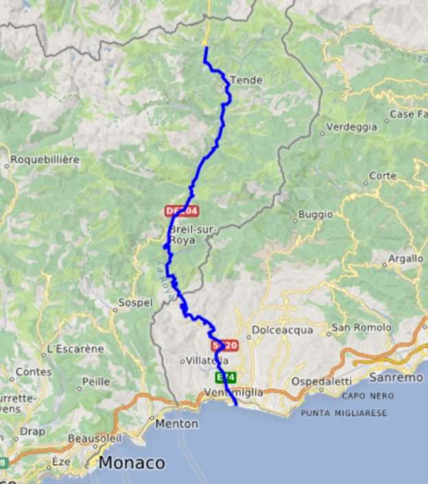
A proposed tramway that did not get built. … The featured image is a map showing the full length of the proposed line which followed National Route No. 204 in France.
Late in the 19th century before a link from Vievola to the Mediterranean was really on the agenda. Alongside the experimental ‘Train Scotte’, [1: p40][2][3] a “local engineer, M. Chatelanat, proposed building a tramway line between Vievola station … and Ventimiglia. He knew the region well, having just overseen the construction of the rack railway from Monte Carlo to La Turbie. [4] Here is the project he presented in an application filed on 7th February 1899.” … [1: p47]
The submission made by M. Chatelanat began, “The electric tramway for which we are requesting a concession is intended to facilitate the movement of passengers and goods in the Roya Valley through a rapid, convenient, and economical means of communication. Currently, to reach Nice and the other communes of the department, the population of the French part of this valley must either travel more than 60 kilometers along the old Nice-Cuneo road, crossing the foothills of Brouis and Braus, in unsafe conditions due to the steep slopes, the height of the passes, and, in winter, the seasonal inclement weather. Or, since the opening of the national road from Breil to Ventimiglia, travel approximately 30 kilometers and cross two customs lines to join the coastal railway line in Ventimiglia. … Between the coast and Upper Piedmont, especially the province of Cuneo, there is a very intense movement of population every year, but if you want to go by train, you have to make a long detour via Savona, which is long and expensive. The province of Cuneo sends to Nice and the coast some of its products that our region cannot obtain elsewhere. On the other hand, our particular products from the South are in demand and consumed in the upper Po Valley. Facilitating the movement of travelers and this exchange of products between Piedmont and the coast will at the same time allow the French populations of the Roya Valley to come easily and quickly to Nice to stock up and connect with the entire French coast without having to cross the Braus and Brouis passes, such is the goal we are pursuing.” [1: p47]
There were a number of projects of this nature being explored at the time. The tramway between Menton and Sospel is an excellent example. [5][6] Others in the valley of the River Var and in the valley of the River Paillon were also built.
M. Chatelanat continues to explain how up to that time it had not been possible to devise a railway scheme that enable a link between Nice and Cuneo. His proposed tramway was not claimed to be a replacement for the planned railway, but while awaiting the development of the railway scheme, the tramway would “provide great services by greatly reducing the communication difficulties between the two regions. The project [would] not provide the speed of the railway, it [would] require two transshipments at Ventimiglia and Tende. Nevertheless, the transport of goods [would] be significantly more economical and passengers [would] find facilities and comfort there which [would] undoubtedly give the population satisfaction, if not complete, at least acceptable. The electric tramway, executed at a width of 1 metre with gradients of up to 70 mm/m and curves down to 20 metres in radius [could not] be used for the passage of standard-gauge locomotives and wagons, and therefore [could not] be used in the event of war.” [1: p48]
Concern about possible conflict was paramount in the minds of many and projects were vetted and often vetoed by the military. M. Castelanat went on to explain that power for the section of the line would be supplied from a hydraulic plant close to Breil-sur-Roya which could easily be put out of action, and if the overhead cables were also removed no use would be possible. He was sure that no advantage would be gained by a future enemy and that “The tramway must therefore be considered a commercial means of communication with no possibility of use in the event of war.” [1: p49]
Castelanat confirmed that electrical operation would mean no problem would be encountered with gradients up to 7% without the need for any regrading of the highway. He planned stations at Breil, Giandola, Saorge, Fontan, and Berghe. The tramway would use National Road No. 204 without any deviations and would cost around 1,400,000 francs. This tramway would, strictly speaking, be only a section of an international line which would have its origin in Ventimiglia and which would go up the valley of the Roya.
A conference including all the statutory interested parties was arranged for 23rd November 1899. Differing views were expressed about whether the tramway could provide a military advantage to the enemy in the case of war. A few months after the conference, on 2nd May 1900, “Chief Engineer Aubé of the Ponts et Chaussées (Roads and Bridges Department) reached the following conclusions: ‘The establishment of the planned electric tramway has lost much of its appeal since the military authorities ceased, with certain reservations, to oppose the construction of the railway from Nice to Sospel and to the Italian border, near Fontan. This line would, in fact, provide the French population of the Roya Valley with the access to Nice they were willing to seek in an economical manner by means of the tramway connecting them to the international station at Ventimiglia‘.” [1: p50]
The effect of the military’s withdrawal of their opposition to the Nice-Sospel-Fontan line was to render the tramway proposals obsolete. It was 1904 before “an international conference finally approved the construction of the Vievola – Breil – Ventimiglia and Breil – Sospel – Nice railway sections. … [Nevertheless] two tram lines were created [in the area]: one from Menton to Sospel, which operated from 1912 to 1931, [5][6] and a line from Ventimiglia to Bordighera, which operated from 1901 to 1936.” [1: p50]
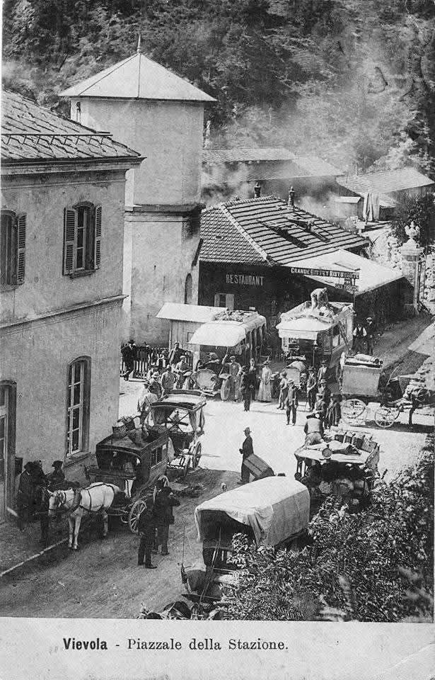
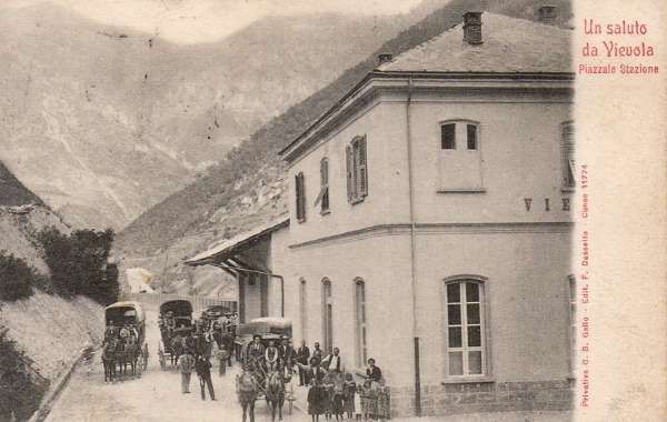
Instead of the ‘Train Scotte’ and a tramway, from perhaps as early as 1900, but definitely by 1st September 1906, a service connecting with trains was introduced between Vievola station and Ventimiglia. The two images below show the mixture of different vehicles in use. Both focus on the road on the West side of the station building at Vievola.
Banaudo et al provide details of a bus service which started on 1st September 1906. The bus service between Vievola and Ventimiglia provided two buses a day from Vievola to Ventimiglia, the first leaving Vievola at 12:15 and arriving in Ventimiglia at 17:00, the second leaving Vievola at 20:40 and arriving in Ventimiglia at 0:40. The cost of the full journey was 5 lire/person. [1: p52]
The advert in the local paper commented that, “Without making the tedious Bastia-Savona detour, travelers can reach the Nice or western Ligurian coast from Cuneo and nearby towns in just a few hours, take care of their business, and return to their hometowns the same day, if they wish, even finding enough time in Vievola to refuel. Every modern comfort will be available in the station buffet, since, with appropriate consideration, the owner, Mr. Giuseppe Borgogno, has asked the Italian State Railways Administration to expand and repurpose the space for this purpose.” [1: p52]
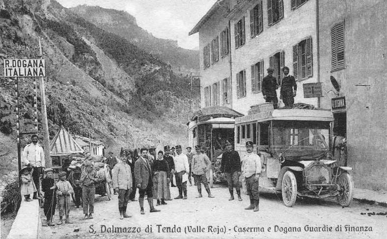
Banaudo et al share details of services which developed over the next few years with pictures of the various buses in use. [1: p52-56]
Other photographs of these bus services include:
References
- Jose Banaudo, Michel Braun and Gerard de Santos; Les Trains du Col de Tende Volume 1: 1858-1928; FACS Patrimoine Ferroviaire, Les Editions du Cabri, 2018.
- https://rogerfarnworth.com/2025/07/26/the-railway-from-nice-to-tende-and-cuneo-part-2
- https://rogerfarnworth.com/2025/07/26/miscellaneous-steam-powered-road-vehicles-scotte-steam-road-vehicles
- https://rogerfarnworth.com/2017/11/23/monaco-to-la-turbie-rack-railway-chemins-de-fer-de-provence-15
- https://rogerfarnworth.com/2018/02/23/the-sospel-to-menton-tramway-revisited-chemins-de-fer-de-provence-51
- https://rogerfarnworth.com/2018/06/08/the-menton-to-sospel-tramway-revisited-again-chemins-de-fer-de-provence-61
- https://www.openstreetmap.org/#map=11/43.9593/7.5662&layers=P, accessed on 27th July 2025.
- https://www.facebook.com/share/p/19YSXYvX1Y, accessed on 27th July 2023.
- https://www.cparama.com/forum/viewtopic.php?p=105633, accessed on 26th July 2025.
- https://www.facebook.com/share/p/19KFiXiVc2, accessed on 27th July 2025.
