Category Archives: French Railways and Tramways

Chemins de Fer de Provence 8 – Tramway in the Tinée Valley

The Tinée Valley – Pont de la Mescla to St Sauveur-de-Tinée

This line was 26.5 Km long and connect villages in the Tinée velley to Nice to Digne line of the Chemins de Fer du Sud which became the Chemins de Fer de Provence.

Like other lines of the Tramways Alpes Maritimes (TAM), the electric current was single phase. The civil engineering works (bridges, tunnels) were executed by the Department.

The line was built in 1911 and operation started on 1st April 1912. Landslides affected the operation of the line in the early months. The original opening was delayed from January to April because of landslides and on 2nd April a further landslide affected several hundred metres of track and destroyed power lines.

The line operated until July 1931.

There were three trains in each direction and the journey along the line took 2 hours and 5 minutes. Between Tinée (SF) and St Sauveur the line climbed 333 metres or about 1000 feet. As well as passenger trains, two freight trains would traverse the line, one in each way. These took about 2 hours and 50 minutes to travel the length of the line.

There are some pictures below.

References:

http://marc-andre-dubout.org/cf/baguenaude/tinee/tinee.htm
“De Nice à Chamonix les réseaux secondaires des alpes françaises” – Jean Robert – G. Fuseau (Montreuil) – 1961.
“Gares de la Côte d’Azur et du Haut-Pays Alpes-Maritimes” – Marie – Equinoxe – 2008.
“Les tramways des Alpes Maritimes” – Delaveau – MTVS – n°46 – 1988.
“Les voies ferrées secondaires des Alpes-Maritimes”- Riffaud – MTVS – 1978.
“Tramways des Alpes maritimes (TAM) et Sud-France” – Magazine des Chemins de fer Régionaux et Urbains – n° 146 – 1978.
“Tramways des Alpes maritimes (TAM) et Sud-France – Compléments” – Magazine des Chemins de fer Régionaux et Urbains – n° 150 – 1978.
Wikipedia

Chemins de Fer de Provence 7 – the line to St. Martin Vesubie.

Route VesubieThis line travelled from the Chemins de Fer de Provence station at Plan-du-Var for 24 km to St. Martin-Vésubie. It was a branch-line of that network. It branched from the main-line after the Vésubie and followed the river bank. It was opened on 1st September 1909 and reached Roquebillière as late as 24th November 1926 before being extended to St Martin-Vésubie. Operations stopped very quickly after that, in 1928.

The route ran past Duranus and Utelle before going through St. Jean-de-la Riviere and on to Lantosque and Roquebillière, before finally reaching St. Martin-Vésubie.

Trams provided the regular service which was twice daily in each direction.

06lantosque01 06plan-du-var01 06plan-du-var02a 06plan-du-var07 06roquebilliere01 06roquebilliere02 06st-jean-la-riviere02 06st-jean-la-riviere07 06stmartin-vesubie01

Tramways St. Martin06stmartin-vesubie04

vesubie015

Theses pictures are nearly all old postcards. They are a selection of available images which can be followed up in the references below.

The small terminus at St. Martin-Vésubie was below the town. In the modern picture, buses have replaced the tram but the passenger building is still standing and well restored. The station had limited facilites but these did included goods depots, a lamp room and a small shop.

References:

http://marc-andre-dubout.org/cf/baguenaude/vesubie/vesubie.htm

“Nice to Chamonix secondary networks of French alps” – Jean Robert – G. Time (Montreuil) – 1961

“Stations of the Côte d’Azur and the High Country Alpes-Maritimes” – Marie – Equinoxe – 2008
“Trams Alpes Maritimes” – Delaveau – MTVS – No. 46-1988
“The secondary railways in the Alpes-Maritimes” – Riffaud – MTVS – 1978
” Tramways of the Maritime Alps (TAM) and South-France ” – Magazine of Railways Regional and Urban – n ° 146-1978.
” Tramways of the Maritime Alps (TAM) and South France – Supplements “- Magazine of Railways Regional and Urban – n ° 150-1978.
Wikipedia

Chemins de Fer de Provence 6 – More Tramways Still!

Tramway de Nice et du Littoral

The Tramway de Nice et du Littoral was a network of trams which served Nice and the communes of the department of the Alpes Maritimes between 1878 and 1953. These notes have been culled and translated from the French Wikipedia site as noted in the references below.

800px-Jardin_public

The Paris Financial Corporation , together with the Society of Public Works and Buildings constructed a network of horse tramways in Nice which was finished in February 1878 and started service on 3rd March that year.

The network comprised four lines: Place Massena – Pont Magnan; Place Massena – Abbatoirs; Place Massena – Saint Maurice; Pont Magnan – Sainte Helena. These were single track lines of standard gauge (1440 mm).Nice_-_Avenue_de_la_Gare

The network was leased to the Compagnie Générale des Omnibus de Marseille, on 4th September 1879. And after that company failed the ‘Société nouvelle des Tramways de Nice (SNTN) took over running the system in 1887.

In addition, in 1895, Compagnie Anonyme des Tramways Électriques de Nice-Cimiez was awarded a concession for a tram line between the Rue de l’Hôtel des Postes and Cimiez zoo. That line was built to a gauge of 600mm and used electric traction batteries because of its difficult route. It was commissioned on 24th November, 1895.

220px-ND_307_-_NICE_-_L'Avenue_de_la_Gare

BJ_106_-_NICE_-_Avenue_de_la_Gare

LL_1139_-_NICE_-_Place_Masséna

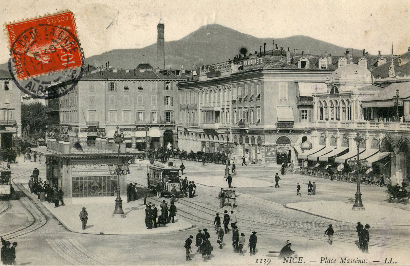
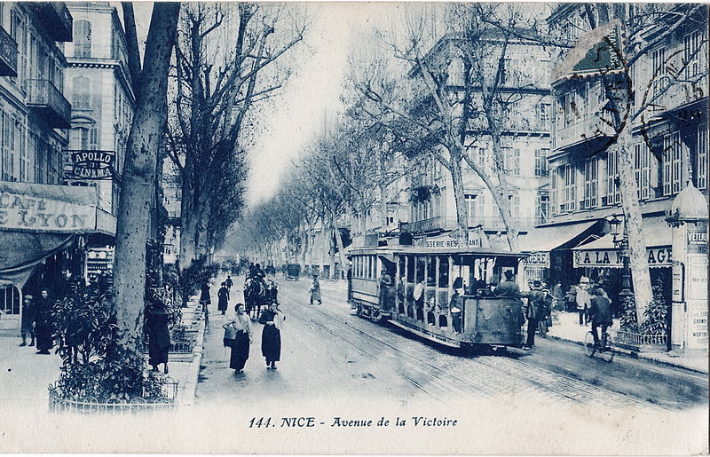
 Place Massena was at the centre of the network and the other two photos show trams on Le Rue de la Gare

La Compagnie des Tramways de Nice et du Littoral (TNL)

This company was created to replace the old “Société nouvelle des Tramways de Nice”, on 16th September, 1897. Its purpose was to: create a network along the Cote D’Azur from Cagnes to Menton , with a branch to the port of Nice and to Contes; it was to electrify the urban network to resume operation to Cimiez which had lapsed.

The lines opened in the following order: Nice – Cimiez , 13th January, 1900; Place Massena – Villefranche-sur-Mer, on 1st February 1900;, Nice – Saint Laurent du Var, 7th February, 1900; Port – Saint Maurice, 12th February 1900;c Nice – Cagnes, 14th March 1900; Nice – Contes, 2nd June, 1900; Nice – Beaulieu, 3rd June, 1900; Magnan – Saluzzo, 3rd November, 1902; and Gambetta – Massena (via Avenue Joseph Garnier), also on 3rd November 1902.

The network centred on the Place Massena where most lines converged. All the lines were electrified by underground gutter and a fleet of 100 trams was used.

Compagnie des Tramways de Monaco

The Compagnie des Tramways de Monaco was founded in 1897 by entrepreneur Mr. Crovetto Monaco. He obtained the concessions on these lines: Place d’Armes – Saint Roman, opened May 14, 1898; Gare de Monaco – Government Square, opened March 11, 1899; Casino – Gare de Monte-Carlo, opened May 3, 1900.

In 1900, the network was linked to the LNP (Line Nice – Monte Carlo). In then in 1908, the company was absorbed by the company TNL. However,by 1931 trams had disappeared completely from the principality.

La ligne de Monaco et Menton

This line connects Nice, Villefranche, Beaulieu, Monaco and Monte Carlo by a linee along the Basse Corniche. It opened on 7th November 1903. An extension from Monaco to Menton Opened on 20th December, 1903. The line connected with with the network of urban tramways in Monaco.

800px-ND_-_Route_de_Nice_à_Monaco_-_La_Baie_d'Eze

Extensions

Extensions were built over time, either to the departmental network or the urban network.

Departmental network

The departmental tram network comprised 14 lines to be built, assigned to the LNP or to the Chemins de Fer du Sud . The latter through its subsidiary: Les Tramways des Alpes-Maritimes (TAM).

800px-Viaduc_du_Caramel2

The LNP obtained the concession of the following lines: Le Pont-de-Saint-Jean (commune de A further route – La Grave de Peille – L’Escarène –  was never built.Villefranche-sur-Mer ) – Saint-Jean-Cap-Ferrat, which opened on 7th December 1907; Nice – Levens , opened 15th June, 1908; Cagnes – Antibes and Cap d’Antibes, opened on 1st February, 1909; Contes – Bendejun , opened on 1st February, 1909; Pont de Peille – La Grave de Peille, opened in 1911; Menton – Sospel: Menton – Villa Caserta, opened in October, 1911 and Villa Caserta – Sospel, opened in April, 1912.Giletta_3205_-_LEVENS_-_Excursion_en_Tram_-_Environs_de_...

The tram to Antibes linked with the network of trams in Cannes.

Urban network

Magnan – La Madeleine , 27 April 1908

Line from Menton to Sospel

This line from Menton to Sospel is open April 15, 1912, as part of the construction of the departmental network. Its length is 18 km. It marks the end of the extension of the LNP. See http://fr.wikipedia.org/wiki/Tramway_de_Menton_à_Sospel for more information.

The apogee of the tram network

The growth of the population of Nice and the surrounding towns and villages led to a rapid development of the network. In 1930, the LNP network consisted of 144 km of track, and had a fleet of 183 drive trams and 96 trailers.

Developments and end of the network

However, very soon the tramways suffered strong competition from road vehicles and by 1934 the coastal routes and the suburban network, including the routes to the various villages and communes had entirely disappeared. The municipality also gradually closed the urban lines, so that by 1939 there were only four lines left: Line 3: Abattoirs – La Madeleine Trinity Victor; Line 9: Port – Saint Augustine; Line 22: Gare PLM – Carras; Line 35: Rue Hôtel des Postes – Cimiez.

During the Second World War, two lines were reopened as all buses were requisitioned: Line 6: Passage à niveau – Pasteur; Line 7: Passage à niveau – Riquier. The tramways to Contes and  La Grave de Peille also reopened.

At this time the network had 48 drive trams and 22 trailers (some additional drive vehicles were also built in 1942).

After the Second World War, the trams were replaced by trolleybuses and the last tram ran on 10th January 1953.

800px-Artaud_&_Nozais_144_-_NICE_-_Avenue_de_la_Victoire

 References

http://fr.wikipedia.org/wiki/Tramway_de_Nice_et_du_Littoral

“Les tramway de Nice et du Littoral,” Connaissance du Rail , No. 320-321,‎ mars 2008

Jean Robert, Nice to Chamonix Secondary networks Alpes-Maritimes, Montreuil. Impr. Time, 1961, p101.
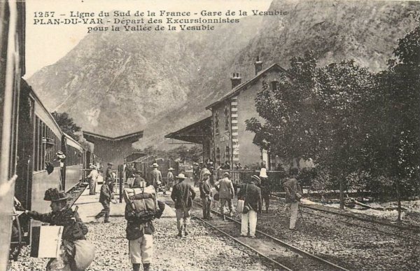
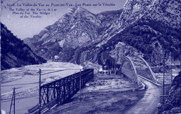
Chemins de Fer de Provence 5 – More Tramways around Nice

Trams in the ValleysImage

After annexing Nice, the French authorities continued to develop the infrastructure in the County of Nice. The coastline was already provided with good road and rail infrastructure. The hinterland and mountains were difficult to access. To open up the villages, the administration implemented the plans established by the Sardinian engineers before annexation.

Many roads used to connect to different villages around Nice could only be traversed with great care and travel times were long. For example: St Martin Lantosque (now St Martin Vésubie) was 10 hours from Nice in 1876 and even with the help of the Digne train in 1894, the journey still took 7½ hours.

It was decided on 10th February 1906 that tramways would serve four valleys:

– The valleys Vésubie 34 km from Plan du Var to St MartinImage

– Valley Tinée 24 km from Mescla to St Saviour

– Valley Estéron 29 km from Pont Charles Albert to Roquestéron

– High Var valley 19 km from  le Pont du Gueydan to Guillaume

The Tram was the economic solution existing dirt roads could accommodate rails but a number of civil enginering structures would be needed. Work began in 1907 on the Vésubie line. It took two years to complete and finally in September 1909 the line came into service. The power system was not complete so the company had to use steam locomotives. This solution resulted in a number of accidents and regular derailments disrupted traffic. Following these incidents, the government implement a series of works to realign and accelerate the implementation of the power supply. Line started regular electrical operation in October 1910.

Line along the Tinée connecting Mescla to St Saviour opened in April 1912. Then the 1st World War postponed the commissioning of lines to Guillaume and Roquesteron until 1923 and 1924.

For a while twice daily tram services carried passengers and goods on these lines. Farmers went to Nice to sell their products, see a doctor or settle their affairs, and tourists and lovers of alpine sports could access the mountains. Nice was served fresh produce direct from the mountains: milk, fruits and vegetables, wood, hay, etc …

In 1929, however, the competition from road transport forced a decision to close the tramways and the last service was closed in 1931.Image

References:

The content of this post has been translated from http://www.mangiapan.net/page.php?id_sujet=38, with some amendments.

Chemins de Fer de Provence 3

I’ve been doing a little research on the history of the lines in the area around Nice.

The first rails were planned alongside the River Var in 1845. At that time Nice and its surroundings were part of the kingdom of Piedmont-Sardinia. The rails were laid on a 12 kilometre length between La Rochette Sur Var and Aspremont. The line began working with a single flat wagon drawn by a mule.

In 1860, Nice was annexed by France. This annexation created various upheavals. Amongst the changes was the generation of a new railway line from Marseilles to Nice which did not pass through major centres of population in the Var – Brignoles, Draguignan and Grasse. Local dignitaries began a process to develop a central line through the Var. This process wass given some impetus when on January 24th, 1872, a collapse between Antibes and Cagnes highlighted the brittleness of the single railway link.

The recent annexation of Nice generated a desire for a direct line to Paris. The valley of the Var was considered for this route even though there is no road in the valley. Puget-Théniers was connected to the coast only by one mule track.

The arrival of Charles de Freycinet at the Public Ministry of Labour resulted in a large number of railway projects. For the area of Provence-Alpes Martime-Côte d’Azur, six lines were planned, linking:

A) Savines with Barcelonnette
B) Digne with Draguignan, via St-Andre and Castellane
C) Digne with the line to Barcelonnette, via Seyne
D) Draguignan with Cagnes or Nice via Grasse
E) Draguignan with Mirabeau, via Barjols
F) Nice with Puget-Théniers.

Single track lines were proposed of standard gauge. Nice’s officials were unhappy and proposed a million franc subsidy to ensure that Nice was included on the main routes of the system – to Digne and the ‘Central Var’.

image

Work commenced on two lines: in 1881: Digne to Castellane; and in 1882: Grasse to Draguignan. The original intention was to use standard gauge but the costs of standard gauge became prohibitive. Initially thought to be in the region of 200,000 francs per kilometre rose to a likely, 300,000 francs/km for Digne-Castellane and even 600,000 francs for Draguignan-Grasse. The decision was made in 1883 and 1884 to redesign the lines to a metre gauge, the routes became more sinous and less expensive and a new railway company was formed – La Compagnie des Chemins de Fer du Sud de la France – to run the concessions.

Work on the Central Var line started, along its full length in 1886 and 1887. For the first time in France, a narrow gauge line attained a length greater than 100 km. The first section Draguignan-Salernes was officially opened on April 23rd, 1888. On August 27th, the line reached Barjols, and then on January 28th, 1889 the terminus of Meyrargues.
The building of the section from Draguignan to Grasse, faced greater geological obstacles and required the building of remarkable civil engineering structures, like the viaduct of Siagne (a metallic bridge of 72 metres high) and the viaduct of Rayol.

image

For a time there was great tension between France and Italy and the standard gauage coastal line was thought to be under threat. An alternative standard gauge route was prosed by putting a third rail alongside the metre gauge line between Nice and Draguignan.

The decision was also taken to construct a coastal line to link towns not served by the standard gauge. The first section St-Raphaël-St-Tropez was inaugurated on August 25th, 1889, then the line was extended to Hyères August 4th, 1890. On the July 1st, 1894, a branchline Cogolin-St-Tropez was opened. The unveiling of the last length of main line, Hyères-Toulon was opened on August 6th 1905.

image

By 1892, La Compagnie des Chemins de Fer du Sud de la France had a 300km network with over 135km in difficult terrain, crossing the boundaries of four departments. The map shows the full extent of the network which was finally completed in 1911 when the Digne to Nice line finally was fully opened. By then the network had 349km of lines. Sadly, the only line left now is that from Nice to Digne.

References:

http://cccp.traindespignes.free.fr/infos-historique-creation.html

Chemins de Fer de Provence 2

image

A network of 1 metre railways was built in the South of France at the end of the 19th century, run by the Chemins de Fer du Sud de la France (S.F.), later to become the Compagnie des chemins de fer de la Provence (C.P.).

600 km of rail lines were built in three areas:

(1) La Littoral. A coastal section ran from Toulon, via Hyeres and Ste Maxime to Fréjus and St Raphaël.
(2) Nice-Meyrargues. A central section ran across the departments of the Var and the Alpes Maritimes, from Meyragues, via Draguignan and Grasse, to Colomars at the Var river, where it connected with the Nice-Digne section. This line ran from the end of the 19th century until it was closed in 1950.
(3) Nice-Digne This section ran from Nice, up the Var river valley to Dignes-les-Bains. Thankfully this line is still in service today.

Tramways were also built in the Alpes-Maritimes. These tramways reached into some of the remotest areas of the Alpes-Maritimes. One example is that from Menton to Sospel.

The “Train des Pignes” is a name that was used locally for the old train on the Meyrargues-Nice and the Nice-Digne lines. Villagers used to collect pine cones (pommes de pignes) in the hills, usually the large cones from a pine called the pigne noir. They would collect the pine cones in large bags and leave the bags beside the railway tracks. The train moved through the hills very slowly — so slowly that passengers could get on and off the train while it was moving at it’s “normal” speed. It was a common sight for these bags of pine cones to be put onto the train as it passed, to be transported to the remote houses and farms for fuel.

A number of branch lines linked the longer lines to places nearby, mostly in the Alpes-Maritimes.

Grasse-Cannes: 1871-1938 for passengers, although the southern part of the line remained open for limited freight operations. The Cannes-Grasse line was reopened in 2005.

Grasse – Cagnes-sur-Mer: left the Grasse-Vence route at Pré-de-Lac and followed the valleys down past Roquefort-les-Pins and Villeneuve-Loubet to Cagnes-sur-Mer.

Vence-Cagnes-sur-Mer: went past Saint Paul-de-Vence and La Colle-sur-Loup. Some of viaducts and tunnel openings are still visible here, from along the road.

Roquestéron: from the Var river, at the Pont Charles-Albert (between St Martin-du-Var and Plan-de-Var), this spur line followed the Esteron valley west to Roquestéron, passing just south of Gilette and Pierrefeu.

Vésubie Valley: from Plan-du-Var, via St Jean-la-Rivière, Lantosque and Roquebillière to St Martin-Vésubie.

Tinée Valley: this branch-line went up the Tinée valley from a narrow gorge at the Pont de la Mescala to St Sauveur-sur-Tinée, providing access to:La Tour, Bariols, Clans, Illonse, Marie and Rimplas.

Dalius Valley: this line followed the Dalius valley up beyond the Gorges de Dalius. It branched off from the main line at the Pont de Gueydan and went to the small town of Guillaumes.

References:

http://www.beyond.fr/themes/lostrailways.html – this page gives a much fuller account of these lost lines and is worth a visit.

Chemins de Fer de Provence

image

Usually when we come to Nice in the late Autumn we travel somewhere on the Chemins de Fer de Provence which runs from Nice to Digne in Provence – about 151 km.

Last year we travelled to Entreveux. This year we did not travel on the train, but walked alongside the line at St. Martin du Var. We also visited the renovated buiding that used to be the Nice terminus of the line. Renovation was only just completed. Here are two photos which show the change – the first from 2007 the second taken this week.

image

image

There was a display of some historic photos some of which you can find below.

image

Since late 2011 the trackwork on the line has been being renewed and they have bought four new DMUs for use on the line.

image

image

image

image

image

image

Sospel to Menton Tramway

image

We visited Sospel in The Alpes Martime today and took the bus from there to Menton.

image

As we travelled down on the bus on the D2566 we saw a number of derelict viaducts.

After a little investigation on the Internet we were able to establish that a tramway was opened from Menton to Sospel in 1912/13 which at first was very well patronised with 1st and 2nd Class accommodation. Often freight wagons we attached to trams as they traversed the line.

When the main line from Nice to Tende was being built, the tramway provided an easy means for transport of materials from the coast. Sadly once the main line was opened usage of the tramway declined and it closed in the 1930s. The route of the tramway very closely followed the line of what is now the D2566. It passed through or close to two villages en-route from Sospel to Menton: Castillon and Monti.

image

image

image

image

image

image

References:

http://transpressnz.blogspot.fr/2012/02/one-time-tramway-from-menton-to-sospel.html

http://www.cparama.com/forum/ligne-du-tramway-menton-sospel-t4789.html

http://www.notrefamille.com/cartes-postales-photos/cartes-postales-photos-Ligne-du-Tram-de-MENTON-a-SOSPEL-A.-M-.–Le-Viaduc-du-Carei.-06500-MENTON-06-alpes-maritimes-553903-67098-detail.html

http://www.delcampe.net/page/item/id,80276116,var,Tramway-line-from-Menton-to-Sospel-the-Viaduct-du-Caramel-Sospel-Alpes-Maritimes-France-postcard,language,E.html

http://www.lafoireauxaffaires.fr/cartespostales/page1.html