
The Mainline Southwest from Knapp Toll Gate in Cheltenham to Gloucester
At Cheltenham the Tramroad terminated at Knapp Toll Gate which was the start of the Turnpike Road to Gloucester. Chris Green says: “The final section ran to the end of The Knapp (in New Street) but was revised to end at the existing turnpike gate on Tewkesbury Road, located at Cheltenham’s western “town’s end” (now Townsend Street).” [1] This suggests that the line was extended a short distance North on Gloucester Road to its junction with Tewkesbury Road. Townsend Road is the extension to Gloucester Road beyond Tewkesbury Road.
We noted in previous articles that most of the descriptions of the Gloucester and Cheltenham Tramroad start from the Docks in Gloucester and run through to Knapp Toll Gate and then talk of the branch to Leckhampton Hill. Their narrative ignores the way in which the tramroad was constructed. Work started first at Leckhampton Hill and once the branch was completed then focussed on the short length from the branch to Knapp Toll Gate before looking towards Gloucester. Bick comments to this effect in his book of 1968: “Initial efforts concentrated on the Leckhampton branch and that part of the mainline from the junction to the terminal depot in Cheltenham. The depot covered one and three quarter acres. The site is now bounded by Market Street and Gloucester Road.” [2: p9-10]
Baxter also notes that the Toll Gate can be picked out on Merrett’s map below. [3: p120]
 An extract from Merrett’s Plan of Cheltenham from 1834.
In Merrett’s early plan of Cheltenham above, the Gas Works are shown occupying a small site adjacent to Coach Road. The next plan below does not record that site as Gas Works but the outline of the buildings is similar once one ignores the frontage onto Tewkesbury Road..
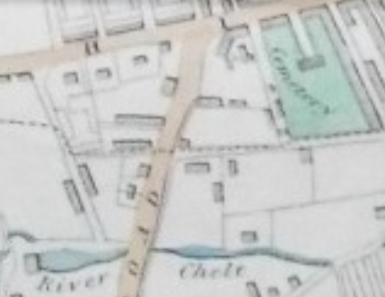
This relatively indistinct copy of a 1843 engraving may well be based on an earlier survey as the Gas Works appears to occupy a smaller site than shown on the 1834 plan above. The tramroad is shown terminating in the top-middle of the extract from the map, in a similar position to that shown on Merrett’s plan from 1834. [5]
 The Tramroad Terminus in Cheltenham, D.E. Bick provided this sketch plan in his book of 1968 .[2: p17]
 The same location on a plan of 1855 with the tramroad rails annotated with red dotted lines. The crucial position of the junction of the various roots has been lost because of damage to the original map(s). The source for these specific maps is the website ‘Know Your Place’. [15]
Chris Green comments that, “the main wharves formed Cheltenham’s first industrial estate with its mixture of trades. They lay alongside the ancient tithing boundary between Alstone and Cheltenham which was delineated by a new highway – now Market Street.” [1]
By 1901, the date of the OS Map below, [4] the area has changed significantly. All signs of the tramroad are long-gone. The Depot, prominent on the sketch map is now used for housing. Alstone Terrace has been subsumed into an enlarged gas works site. Knapp Road is now Market Street and the site of Albion Brewery now appears to the the town Cattle Market. The layout of the streets is very similar in both the sketch map and the OS map extract. OS 25″ Map from 1901 sourced from the National Library of Scotland [4]
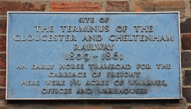
Plaque on the Hop Pole Inn on Gloucester Road. [6]
 The site of what once fwas the town gas works in Cheltenham is now the location of its Tesco Superstore (Google Streetview).
 DW Sports have built their store on the footprint of one of the old gasometers (Google Streetview).
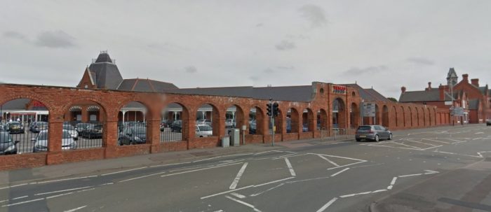
 The Depot area in the 21st century (Google Maps).
The Tramroad between Knapp Toll Gate and the Junction with the Branch line to Leckhampton Hill followed the Southeastern verge of Gloucester Road in a Southwesterly direction to the junction at what soon became Queens Road. Beyond that point the line ran across the entrance of what was to become first Lansdown Station and then Cheltenham Railway Station down to the junction between Gloucester Road and Lansdown Road.
Baxter, writing in 1953, talks of two cottages built after the closure of the Tramroad. “At the junction of Lansdown Road and Gloucester Road are two houses curiously built in a position sideways to the Gloucester Road with their front doors facing each other across to narrow elongated front gardens which are obviously the width of the original Tramroad land, and it seems almost certain that these represent two plots of tramroad land sold off for building.” [3: p121]
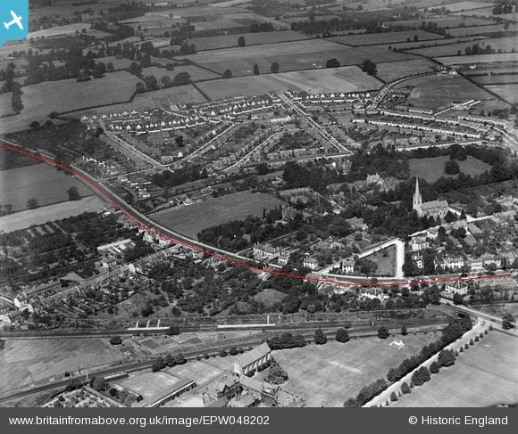
I have looked at a number of maps from around the time that Baxter was writing, and found it difficult to identify the two properties that he refers to. Two examples of the maps are below and they are accompanied by an aerial image from the 1930s of the same area.

 Publishing this article has produced a very helpful response from Richard Beamer. I have produced an enlarged extract from the second OS Map above which shows the two properties concerned. This results in a slight amendment to the alignment of the tramroad away from the kerb of Gloucester Road into what are now the front gardens of some of the properties. Richard Beamer comments that these two cottages had disappeared by the time of mapping work undertaken in the 1960s.
Beyond the junction between Gloucester Road and Lansdown Road the tramroad continued along the Southern verge of Gloucester Road. You might expect that the turnpike road was in existence before the tramroad was constructed, however, the reverse is true. The turnpike road was not constructed until the tramroad was operational. Bick tells us that in the same parliamentary session that saw the tramroad powers granted (April 1809) a parallel Acts was granted authorising “a new turnpike road from [Cheltenham] to meet the existing Gloucester road at Staverton Bridge. …The turnpike road and tramroad … were largely supported by the same people, and the new road was planned to run alongside the tramroad, taking advantage of its easy gradients and ready conveyance of stone for construction. … Stone for the road’s upkeep was to be carried toll free on the tramroad. ” [2: p8]
As we have noted the tramroad route was chosen to minimise the use of gradients which would have limited the capacity of the trams. Bick comments that the turnpike road was as a result not a great success, as the route was longer than it needed to be for road traffic. “Financially the road never compared with its iron companion.” [2:p8]
Road and tramroad were tightly paired as they travelled Westwards. The modern roads follow, relatively faithfully the line of the old Gloucester Road.
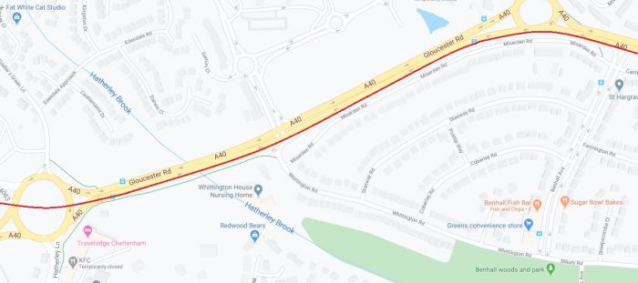

On the Google Maps extracts above, the tramroad alignment is plotted over the current road arrangement. For a distance it runs along the South side of the A40 before turning away up the old Gloucester Raod (B4063). In order to make the modern road alignments work at the junction of the A40 and the B4063 the modern alignment of the B4063 has been moved away from its old alignment and so also from the tramroad. The old tramway and the old turnpike road followed the approximate route shown above. The roundabout from which the picture is taken is the junction of the B4063 and the A40. The B4063 heads along the right side of this image (Google Streetview).
 The view back to the East along the alignment of the old Tramroad towards the modern roundabout junction with the A40. The modern B4063 is on the left of the image. (Google Streetview)
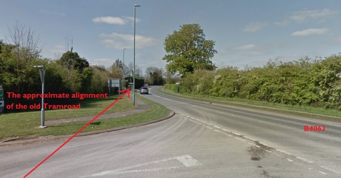 Looking to the West along the B4063 today. (Google Streetview)
The route of the old tramroad line runs from Arle along the B4063 towards Staverton. It is thought that the old Tramroad ran a little removed from the turnpike road at the point where the Old Goucester Road meets the B4063. The verges at this location in particular are wide and may have accommodated a stabling point for the horses which pulled the trams and the tramroad itself probably passed behing the pub at this location – the former Plough Inn (now White Lion House (AGD)). The route of the old tramway probably passed to the South of the pub at Staverton Junction. (Google Streetview)
 25″ OS Map from the early 20th century. [7]
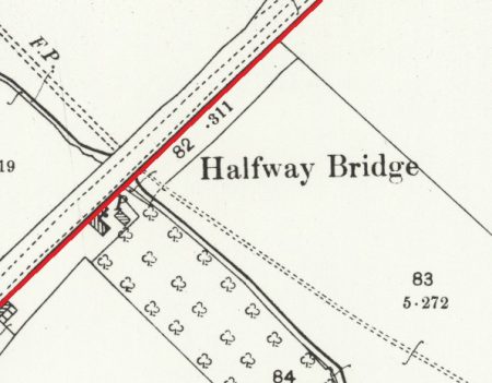


The Hare and Hounds Pub in the 21st Century. (Google Streetview)
Beyond Staverton, the road and the tramroad converged again and the old tramroad followed the Southern verge of the road once again. Halfway Bridge was once two parallel structures with three brick arches which took both turnpike and tramroad across Norman Brook. “The tramroad bridge … has long since disappeared, but a perfect image of it remains supporting the B 4063 itself. We know this because in January 1818 an advertisement appeared for contractors to build a new road bridge with three arches ‘to correspond and adjoin with those under the Rail Road’.” [10]
There has been a significant amount of modern development in the immediate vicinity of the B4063 as it passed to the Northside of the Airport and on into Churchdown before gradually drifting back towards what is now the A40 but which was just open fields!
On the way down to the location of the modern roundabout, the tramroad passed behind the Hare & Hounds Pub. The alignment close to the rounabout followed the old B4063 which was diverted to provide good access to the new A40 roundabout.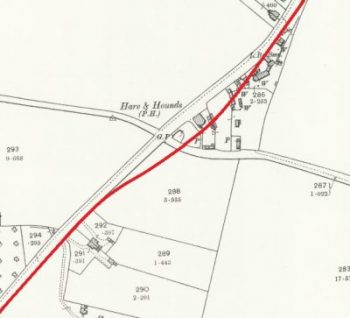
Some realignment of the B4063 has therefore taken place which takes it away from the old turnpike and tramroad alignment. The first side-by-side images below [8] demonstrate that movement. The old tramroad alignment is now lost under the A40 roundabout!
Again, just beyond Elm Bridge, the tramroad deviates away, for just a short distance) from the modern B4603 following the alignment of the old highway. The second side-by-side images illustrate this. [9]
 It then crossed Cheltenham Road and ran down along what is now Elmbridge Road. Baxter indicates that when the tramroad was built it crossed open fields along this length. The road was built after the tramroad was in use. [3: p120]
 The Tramroad runs down Elmbridge Road into Gloucester [11]
 Elmbridge Road became Armscroft Road to the south side of Ermin Street. Ermin Street is now the A38 Barnwood Road. [12]
At the point where Armscroft Road turned sharply to the Southeast the old Tramroad made its way across open-ground. Its route could still be followed as a footpath on an embankment until relatively recently and part of the route remains as a tree-lined route towards what was Gloucester Locomotive Depot.. The depot is just visible to the bottom left of the map extract above. The map extract below comes from the OS Maps online and the old Tramway route is marked with dotted red lines [12] It left Armscroft Rod, passed across the end of what is now Brookfields Mews and then ran on to cross Wotton Brook before crossing the Gloucester MPD site.


1855 Ordnance Survey Map. [13] 1901 Ordnance Survey Map. [14]
The next article in this series will cover the length of the tramroad from Barnwood MPD to the docks in Gloucester.
References
- Chris Green; The History Of Alstone – Volume 1; http://www.historyofhestersway.co.uk/vola1/ha1_11.php, accesssed on 4th May 2020.
- D.E. Bick; ‘The Gloucester & Cheltenham Railway and the Leckhampton Quarry Tramroads’; The Oakwood Press, 1968.
- B. Baxter; The Route of the Gloucester & Cheltenham Railway; The Railway Magazine, February 1953: p117-121 & p133.
- https://maps.nls.uk/geo/explore/#zoom=17&lat=51.90571&lon=-2.08672&layers=168&b=1, accessed on 4th May 2020.
- http://www.rareoldprints.com/z/20611, accessed on 30th April 2020.
- https://www.closedpubs.co.uk/gloucestershire/cheltenham_hoppole.html, accessed on 4th May 2020.
- https://maps.nls.uk/geo/explore/#zoom=17&lat=51.90047&lon=-2.15933&layers=168&b=1, accessed on 5th May 2020.
- https://maps.nls.uk/geo/explore/side-by-side/#zoom=17&lat=51.88077&lon=-2.19707&layers=168&right=BingHyb, accessed on 5th May 2020.
- https://maps.nls.uk/geo/explore/side-by-side/#zoom=17&lat=51.87578&lon=-2.20740&layers=168&right=BingHyb, accessed on 5th May 2020.
- https://glostransporthistory.visit-gloucestershire.co.uk/First%20Railways%20in%20Gloucester.htm, accessed on 5th May 2020.
- https://maps.nls.uk/geo/explore/#zoom=17&lat=51.87403&lon=-2.20985&layers=168&b=1, accessed on 5th May 2020.
- https://osmaps.ordnancesurvey.co.uk/51.86335,-2.22055,18, accessed on 5th May 2020.
- https://maps.bristol.gov.uk/kyp/?edition=glos, accessed on 6th May 2020.
- https://maps.nls.uk/view/109724691, accessed on 6th May 2020.
- https://maps.bristol.gov.uk/kyp/?edition=glos, accessed on 7th May 2020.

Roger
I must congratulate you on such a well researched article. I must have used the embankment past the back of Barnwood shed hundreds of times sixty-odd years ago.
I currently live four hundred yards from the new roundabout at the end of the A40.
To update the final couple of sentences “This provides, ” he says,”a convenient footpath for enginemen going to and from the sheds from the Barnwood district. For this reason, a culvert which formerly carried the embankment over the Wotton Brook, and which has at some time been washed out by a flood, has been replaced by a footbridge built of old railway sleepers.” [3: p120] As we have seen a portion of that embankment remains but the footbridge, as far as I can tell, is long-gone.”
Yes, the sleepers forming the footbridge have long gone, but the bridge is now there with a tarmac base and forms part of a cycle track/footpath between Blinkhorns Bridge Lane and Metz Way.
Could I please have your permission to post this to two local Facebook Groups – “Gloucester’s Old Railways”, “Old Railways of Gloucestershire” and “Gloucester, a Trip back in Time”.
Once again, very many thanks for the incredibly detailed article.
Regards
Roger Smith
(roger.smith2019@hotmail.com)
Yes, of course, Roger. Please do post the links to all three of the articles completed so far. I am very happy to share. I will update the end of the third article now. Thanks for the up-to-date local knowledge.
Hi, the stables for the horses was just off the junction of Armstrong Road and Barnwood Road also there use to be a branch line running up the side of Gloucester Irish club into Gloucester following the Ash path along the old station where Asda now is hope this may help cheers mark
Yes Mark, interesting. can you give me the sources for this info. Kind regards Roger.
Hi again Mark. It may be my lack of knowledge but I have not been able to find Armstrong Road in the vicinity of Barnwood Road. Could you perhaps point me in the right direction?
Best wishes
Roger
Hi, you have mentioned the branch by the Irish club in part 4, I know about the stables because o was told by a neighbour in 1980 when I lived at 61 Barnwood Road that the row of houses was for the tramway workers who used horses from the stables over the road in yard that use to back onto ‘b’ grade domestics that is on the corner of armscroft Rd and Barnwood Road hope this helps?? Cheers mark
Thank you for both your messages.
Hi, the stables where behind ‘B’grade domestics on the corner of armscroft Road and Barnwood Road I use to live in 61Barnwood Road mfrom 1980 and a very old neighbour told me that the row of houses we lived in was for the tramway workers and the stables was over the road behind the little Park opposite. You have mentioned the branch on the part 4 it’s been a great read!! Hope this helps cheers mark
Much appreciated, Mark. Thank you for the local knowledge and the kind words.
The two houses Bick refers to are alongside the ‘E’ of Gloucester Road on the 1892 map: they each had long gardens, presumably formed on the tram road formation. I seem to remember that they were still there in the mid-1960s, but no longer.
Richard Beamer
Dear Richard
Thank you for your comments, much appreciated and very helpful. I have adjusted the text of the article.
Best wishes
Roger
Richard – excellent series on the G & C Tramroad. Do you plan to electrify and take us up the Prestbury Road next?
Pingback: Gloucester Docks and Railways – Part 1 | Roger Farnworth