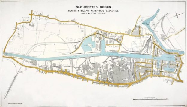
 The featured image above is a 1951 Plan of Gloucester Docks which was produced by the Docks and Inland Waterways Executive South Western Division in 1951 which was found on the Llanthony Secunda Website. [14]
Railways on the East Side of the Docks
The railways on the East side of the docks replaced the older tramroad/plateway which served the dockside. They were sidings from the Midland Railway in Gloucester, whereas the railways to the west of the docks were sidings from the Great Western Railway.
It had initially been intended to follow the alignment of the Gloucester and Cheltenham Tramroad into the docks from the East. This was always going to be impracticable as the tramroad operated with tight curves through the streets of Gloucester. In the end, these Eastern sidings had to be served from elsewhere. Within the main docks area they took over the role of the tramroad in two separate phases. The first phase came about as a result of the tramroad route along the east side of the Main Basin between it and what became the Victoria dock, was cut as part of the construction of the Victoria Dock and was not re-instated.
In this phase, the Midland railway sidings took over the whole of the area North of the Barge Arm. A new Midland Railway Branch was built to make this possible – The High Orchard Branch.
In a second phase the Midland Railway took an effective monopoly over the area immediately to the South of the Barge Arm. It was at this time (1861) that the tramroad closed completely. These additional sidings were also served from the High Orchard Branch.
Steam was used on the main sidings of the new system but horse were still gainfully employed on some of the wharves, warehouse sidings and quays of the docks, specifically where these were accessed by wagon turntable rather than points.
The High Orchard Branch
I first came across the branch when reading one of the volumes of ‘British Railway History in Colour’ published by Lightmoor Press and compiled by Neil Parkhouse. [1]
In this volume of what is a magnificent series of books there is a section dedicated to the High Orchard Branch and the Sidings on the East side of the Docks. [1: p51-80]
Parkhouse notes that the Midland Railway opened its High Orchard Branch in 1848 which was 6 years before the Great Western Railway opened its Llanthony Branch. [1: p52] He notes that as the 19th century progressed the network, in and around the Docks, developed significantly. Many of the sidings were owned by the Docks Company and leased jointly to the two railway companies to operate. This did not work effectively and from 1880 it was agreed that the Midland (MR) would operate on the East side of the Canal and Docks and that the Great Western (GWR) would operate on the west side of the site. [1: p52]. This arrangement held, with the exception of some disputes over a new branch built by the Midland as the end of the 19th century approached.
The 1843 map of Gloucester does not show the Midland Railway line which curved through the eastern area of the City of Gloucester. It clearly shows the route of the old tramroad and Gloucester Railway Station which sat on the East side of the old city on roughly the same latitude as the cathedral. The MR took over the Bristol and Gloucester Railway and the Birmingham and Gloucester Railway in 1845 and the original station became the MR Station in the City. This is shown on the extract from the map drawn 1843 below.

The Midland Railway Station in Gloucester – the image is an extract from Causton’s 1843 Map of Gloucester. [2]

The Midland Railway Station in Gloucester – the image is another extract from Causton’s 1843 Map of Gloucester and shows the planned railways close to the station. [2]
In 1851 the GWR built its South Wales line across the North of the city and built its own station to the North of the MR station. The approximate line of the GWR South Wales Route near the MR Station is shown on the plan above. The two stations shared the same throat although they were still operating on different track gauges.
In 1854 the MR built its Tuffley Loop because the rapid expansion of the rail network had left their station difficult to work. The Loop followed the first part of the original High Orchard Branch and then headed away t the Southeast to meet the MR mainline which ran to the East of Gloucester. Parkhouse notes that the issues surrounding the MR station were only partially resolved by the construction of the Tuffley Loop. It did however allow the MR to “dispence with the operation of broad gauge trains. The line was effectively and extension of the High Orchard Branch to the docks, with the twin tracks of the loop curving away from the docks branch between Barton Street and what was to be the site of California Crossing.” [1: p82]
 The 1852 Map drawn for the Local Board of Health can be found in an interactive form on the ‘Know Your Place’ Website [3] This Map predated the construction of the Tuffley Loop. It shows the original form of the High Orchard Branch and its route through into the docks There is a short section of the route which falls outside the mapping area. The name ‘High Orchard’ acknowledges the early use of the land as an Orchard for Llanthony Priory.
In the 1852 map the developments in the station area are visible – the GWR line is shown as was, at the time, only recently open to traffic. The station ‘yard’ and sidings of the MR station are by this time more complex.[3]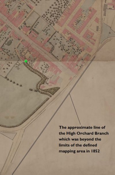
The Branch crossed Barton Street close to the old Tramroad and curved to the West around the bottom of Gloucester’s Park. On the curve, it became double-track for a short distance which, I guess, gave trains room to pass and may also have been used as storage space when trains arrived before they could be taken down into the docks. This can be seen on the third of the map extracts on the bottom side of the Park. [3]
As it left the Park area, the Branch once again became single track. This can be seen at the left-hand side of the third extract from the 1852 map. It was then just a matter of a few 10s of yards before the dock complex was reached and the fourth map extract shows this area. [3]
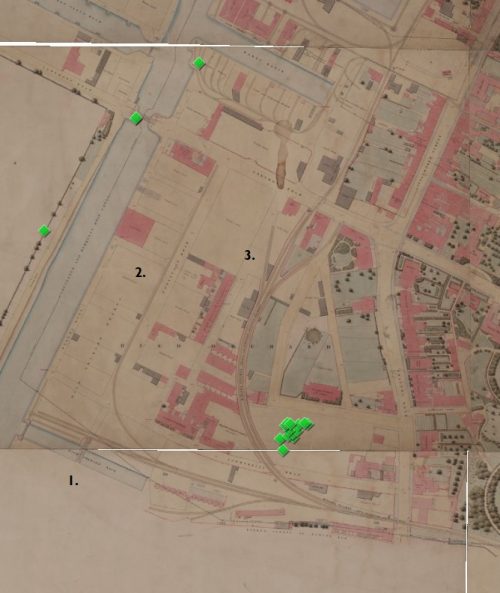
The fourth map extract shows three main areas to the South of the Barge Arm which can be seen centre-top of the map extract.
First, there are sidings around the High Orchard Dock at the bottom left of the extract. (1)
 Second there is a single long siding giving limited access to the rail network for canal frontages between High Orchard Dock and the more northerly Barge Arm. (2)
Third, a series of sidings (3)accessed from the main branch which curved round to the north to serve properties North of the Barge Arm.
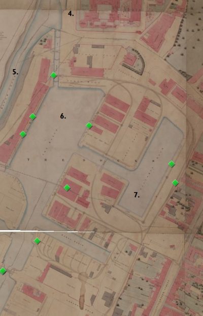
The fifth extract from the 1852 Map (adjacent) highlights the sidings which served the Northern part of the docks at this early stage. It is worth noting that the Tramroad sidings on the North side of the Barge Arm have now been removed and replaced by standard-gauge lines. On the map, the Gaol can be picked out centre-top (4) next to the River Severn (5). The two main basin are central to the extract – The Basin (or Main Basin) (6) and Victoria Dock (7). These two docks are linked by a short canal which severed the tramroad access and which has not by the time of the map been bridged by the MR sidings. [3]
The next series of maps of Gloucester which we have access to are those prepared between 1880 and 1925. Three series of 25″ OS Maps appeared in relative quick succession – Series 1 (1886), Series 2 (1901) and Series 3 (1923).
Firstly, Series One. In the first extract below we see what was the northern end of the High Orchard Branch in the East of the City. By the time this map was drafted, the railway network had expanded considerably. The pattern of railway lines close to Gloucester Station had begun to look much like it would be in later years. The two Gloucester Stations (A & B) were at this time still adjacent to each other. The Midland Loco Shed is in a position (C) which would soon eb seen to be preventing expansion. The lines of the Tuffley Loop follow what was the older High Orchard Branch across Barton Street (D).

Very little else on the High Orchard Branch differs from what can be seen on the Series 2 Map extracts below. However, one area which was still under used at this time, was that South of the early buildings of the Wagon Works shown on the adjacent extract. Railway sidings hugged the canal bank to provide access to timber yards further south along the canal. These appear in the bottom left of the map extract.
The area alongside the Canal at that location was known as Canada Wharf.
Secondly, Series Two, The first extract below shows that the Midland Station had been moved to the Southeast when this map was drafted. This meant that it was possible for the New Midland Station (Eastgate) to be a through station, making the handling of trains significantly easier. The Loco Shed to the east side of the map is the GWR Shed at Horton Road. A footbridge now links the two stations. The MR Loco Shed was just off the east side of the map extract.
 EPW041489 – Britain From Above – Great Western Road, the railway stations and city centre Gloucester, from the east, 1933. [4]
 EPW024156 – Britain From Above. Central Station, Eastgate Station and railway sidings, Gloucester, 1928. [5]
Heading to the Southwest across the Barton Street level crossing the map shows the Tuffley Loop leaving Eastgate Station (the MR Station).
The second extract shows the High Orchard Branch leaving the Tuffley Loop at a very shallow angle and crossing Parkend Road, again on a very shallow angle and curving round to the West.

EPW024171 – Britain From Above. The area between Park Road and the railway station, Gloucester, 1928. This shows the route of the Tuffley Loop down the East side of Gloucester and the point at which the High Orchard Branch left that route. [6] An extract from EPW050780 – Britain From Above. The photograph was taken in 1936 and the extract shows the junction between the High Orchard Branch and the Tuffley Loop. California Crossing can be seen in the bottom-centre of the image. [50]

An extract from EAW012211 – Britain From Above. Gloucester Docks and the surrounding industrial area, Gloucester, 1947. This shows the High Orchard Branch and its sidings on the far side of the Canal. The photograph is taken from the West. [7]
 The third extract, which appears above at a slightly smaller scale, shows the Branch crossing Lower Southgate Street and providing access to enhanced siding approaching the canal. Space has been created for these sidings by infilling the High Orchard Dock which was visible on the 1852 Map. Gloucester Carriage and Wagon Works had grown significantly since they first opened in the 1860s and had a complex of lines serving its site.
As shown by the fourth map extract, the two lines running north from the sidings had changed little until they reached Lanthony Road. An East-West line crossed Lanthony Bridge linking the West and East Sidings. and which met the ongoing Midland lines at a trailing crossing. This map also shows that new sidings had been developed on the South side of the Barge Arm to serve premises which in 1852 were still being served by the Gloucester and Cheltenham Tramroad.
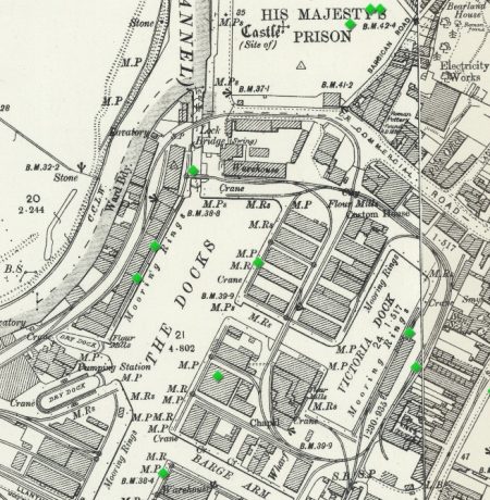 The fifth extract shows the most northerly end of the docks complex. Things to note here include: the line crossing the bridge across the canal between the Main Basin and Victoria Dock; the two link bridges across the locks leading to the River Severn, North of the Main Basin which allowed access to the West side of the Main Basin; the fact that no attempt has been made to serve the quays on the river to the North of these Locks.

An extract from EAW012204 – Britain From Above. Gloucester Docks and the surrounding warehouses, Gloucester, 1947. [8]
 Finally, above, on the Series 2 mapping, we have zoomed out to get an idea of the railway system South of the Railway Carriage and Wagon Works alongside the Gloucester and Berkeley Canal, which were referred to in the notes about the Series 1 mapping. The Carriage and Wagon Works had expanded and new timber yards were now served by the railway.

An extract from EPW016965 – Britain From Above. This shows the Baltic Wharf and timber yards on the Gloucester and Sharpness Canal, Gloucester in 1926. Very soon after the Series 3 OS Maps were produced. The map extract below covers this area. [9]
 By the 1950s, the Carriage and Wagon Works was redeveloped and modernised. External track-work seems to be only marginally changed from the 1920s.
 1950s 25″ OS Map of the Carriage and Wagon Works. [10]

An extract from EAW032295 – Britain From Above. The Gloucester Railway Carriage and Wagon Company Works and environs, Gloucester, 1950. The main sigins of the High Orchard Branch seem tightly hemmed in between the industrial buildings. [11] An extract from EAW032296 – Britain From Above. The High Orchard Branch sidings are shown to good advantage, 1950. [12]


The modern Trier Way (A430) follows the line of the old High Orchard Branch as far as Southgate Street. This is mapped on the adjacent image and on the one below. [13] The next map extract shows the approximate relation of old lines to the modern High Orchard Area, Shopping Centre and St. Ann Way (A430).


The final map in this sequence shows the Northern end of the docks. These maps do not always appear at the same scale in this blog. They are schematic illustrations rather than accurate plans. The lines shown for the dock railways and sidings are only approximate. Detail can be gleaned from the earlier maps above. However, these plans illustrate that modern development has generally respected the alignment of the old dock buildings. This clearly has not bee possible in the case of the new shopping development at High Orchard.
The High Orchard Branch
We have already noted that this Branch left the Tuffley Loop just to the south of the Barton Street Level Crossing. Up to now, we have primarily concentrated on mapping and aerial images to give an idea of the Branch and its sidings. We now look at the route of the Branch and its sidings from ‘street’ or ‘rail level’ wherever that detail is available to us.

This view was taken in 1975 looking North towards Barton Street Crossing. The High Orchard Branch has not yet been lifted and is the railway track to the left of the mainline, leaving the mainline to the left of the DMU, (c) David Stowell / Towards Barton Street / CC BY-SA 2.0 [16] California Crossing looking North towards the Barton Street Crossing. The Park can be seen to the left of the image. The High Orchard Branch has left the Tuffley Loop and runs across Parkend Road at a very shallow angle behind the crossing gate in this picture, (c) David Stowell / California Crossing / CC BY-SA 2.0. [17]

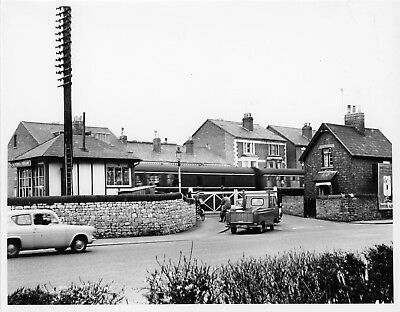 The picture above is taken, as shown by the red arrow, on the adjacent map extract.The next picture shows the California Crossing at an earlier date and is taken from within the park. The tracks of the High Orchard Branch cannot easily be picked out on this picture, but they run under where the Ford Anglia is waiting to turn across the Level Crossing. [18]
There are some excellent pictures of the eastern end of the High Orchard Branch in Neil Parkhouse’s book [1: p53-58], in Ben Ashworth’s pictorial essay on the railways of Gloucestershire in the steam era [21: p6-8], and in Colin Maggs’ book, ‘The Branch Lines of Gloucestershire’ [22: p66] but not many that I can find across the web. There are also photographs available in the Gloucestershire Archives. [23]
Colin Maggs’ book includes a picture of the gated entrance to the High Orchard Branch which was taken on 9th March 1968 by Derrick Payne. Ben Ashworth’s book includes a series of great photographs of steam at work in the docks area and a couple of excellent shots of the eastern end of the branch: one of ex S&DJR 2-8-0 53806 crossing Parkend Road heading away from the docks on 12th May 1961; and one, taken on 4th June 1962, showing MR class 0F 41535 hauling a timber load away from the docks and passing under the footbridge which gave access to the South side of the park from Weston Road.

Early 21st century view looking South across the location of California Crossing (Google Streetview).
There are a few photographs of the area around California crossing in Ben Ashworth’s first book, “The Last Days of Steam in Gloucestershire.” [51: p59-60] These include: a shot of Locomotive No. 41537 crossing Parkend Road on its way onto the branch, travelling cab first; S&DJR travelling tender first onto the branch; and Wigmore Castle on the Tuffley Loop heading south across California Crossing.
As we have already seen, the branch curved to the West on the South side of Gloucester Park. Neil Parkhouse’s book should to be consulted if you wish to see images along the length of the line as it runs towards Southgate Street. [1: p53-58] Ben Ashworth’s book also includes a picture of 41535 on 17th December 1962, shunting the yard at High Orchard which took it East along the branch before setting back across the Crossing at Southgate Street.
The adjacent picture shows the level crossing at Southgate Street and is taken looking West into the docks complex. The factory buildings on the right are part of the former Fielding & Platt engineering works. [19]The ‘Fielding and Platt History’ website [20] has a number of pictures which show the High Orchard Yard.

The same Junction in 2002 after the building of St. Ann Way, but before the demolition of Fielding and Platt’s site to make way for the High Orchard Shopping Centre (https://www.gloucestershirelive.co.uk). [24] To the West of Southgate Street the line divided to form High Orchard Yard. Most of that Yard is now under the buildings of the High Orchard Shopping Centre (Google Streetview).
 A night-time shot of the level crossing on Southgate Street/Bristol Road. The crossing provided access from the Branch into High Orchard Yard (c) Henry Jenner. [20]
 High Orchard Yard with the tracks in the process of being lifted. (c) Paul Regester. [20]
 High Orchard Yard again, this time prior to dismantling of the track-work but further into the site. (c) Paul Regester. The image shows the rear of No. 1 Hydraulic shop, the Boiler Yard and the Former Iron Foundry. The tracks curving away ahead of the photographer are the lines which provide access the the main dock basins. [20]
 This picture is taken from the South looking towards No. 1 Hydraulic Shop (c) Ralph Tucker. [20]
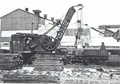
Paul Regester notes this picture as showing the unloading of an F&P Press for modification in the plant (c) Paul Regester. [20]

High Orchard Yard – Crane at work, probably taken looking West towards the Canal (c) Paul Regester. [20] This final shot in the sequence appears to have been taken from the West looking back towards the Level Crossing and shows No. 1 Hydraulic shop behind the locomotive and crane, (c) Paul Regester. [20]

High Orchard Street looking North towards Gloucester Cathedral, showing the original Fielding and Platt buildings, (https://www.gloucestershirelive.co.uk). The railway to the main basin and the Victoria Dock runs to the right of the building in the centre of this image. Llanthony Road is just out of sight between the buildings two-thirds of the way up the image. [24] Looking North along High Orchard Street in July 2018 (Google Streetview).
 Turning to the left from the image above we get a glimpse of the Canal at Bakers Quay. Merchants’ Road runs into the shot from the bottom-left (https://www.gloucestershirelive.co.uk). [24]
 Street level view north along Merchants’ Road in 2019 (Google Streetview).

Llanthony Road looking West towards Llanthony Bridge in 2002. There was a line running East-West across Llanthony Bridge which connected the Docks sidings either side of the Canal, (https://www.gloucestershirelive.co.uk). [24] Llanthony Raod looking West in 2019 from roughly the same position as the image above (google Streetview). There has been major redevelopment of this area.

Llanthony Road Bridge lifting to allow access along the canal © Copyright David Martin and licensed for reuse under a Creative Commons Licence – CC BY-SA 2.0. [25]

Looking North using a long telephoto lens along what was the line of the Old Docks Railway. The older building which is coloured white, and which is only just visible below the tower of the Cathedral and above the parked cars, is Albion Cottages which can be seen on the images below. The photograph was taken from Llanthony Road. (Google Streetview). There is a photograph in Ben Ashworth’s collection from a similar position but taken in April 1962 which shows No. 41537 advancin towards the crossing at Llanthony Road and the line diverginf to run along Llanthony Road to the swing bridge. [21: p13]  The old docks railway alignment (Google Streetview).

The same location adjacent to Albion Cottage (c) Roger Marks. He comments: The track-bed of one of the former Midland Railway lines at Gloucester Docks, looking towards Llanthony Road from the Southgate Street docks entrance in 1991 and 2015. The building on the right is known as Albion Cottages. If you look carefully at the wall on the left on the left hand picture, you can make out two gate pillars. This was the entrance where the Gloucester & Cheltenham Tramroad once entered the docks. The gateway was bricked up for many years but has recently been restored. [26]
 Tank Engine LMS 41537 (0-4-0T) close to the entrance to the docks off Southgate Street. Albion Cottages can be seen behind the locomotive. [15] The following monochrome image is taken looking East along the front of Albion Cottages. [27]

A pair of replica Gloucester & Cheltenham Tramroad wagons on display at Gloucester Docks on a section of original track. They stand on the original route of the Tramway, which entered the Docks through the gateway in the background. 21st May 2015 (c) Roger Marks. [27]

No. 41537 again. This picture is taken from almost the same position as the preious one featuring this locomotive, only the photographer is now facing West rather than facing South on 13th April 1959 (c) Ben Brooksbank
(Creative Commons Attribution Share-alike license 2.0) [35]
Ben Ashworth’s first photographic collection includes a shot of 41537 travelling North away from the Southgate Street entrance to the docks in 1962. It was waiting for some road vehicles to be moved out of its way before propelling its train of four covered wagons towards the Commercial Road entrance to the docks. [51: p59] The colour image below mimics the same movement but a little further to the North.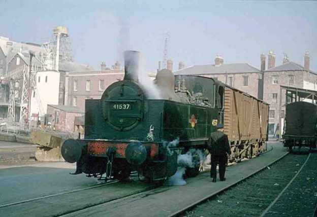 This photograph of No. 41537 is taken from the East side of Victoria Dock looking North. The building at the North end of the dock are still recognizable in the 21st century. Permission to use this image was kindly given by the Tewkesbury Direct website. [36]
 A view from a similar location in the 21st century (Google Streetview).
 A five-plank open goods wagon displayed outside the National Waterways Museum, Gloucester. 29th March 2009 (c) Roger Marks. Immediately behind the wagon, just beyond the roofed area to the left, is the Barge Arm. The short length of track on which the wagon sits is on the line of one of the old docks railways which surrounded the Barge Arm. Turning 90 degrees to the left would bring the main building of the Museum into the picture.[28]
 Close to the same location in 2012 (Google Streetview).

Severn & Canal Carrying Company motor narrowboat “Oak” in the Barge Arm, Gloucester Docks. 21st May 2015 (c) Roger Marks. Biddle & Shipton’s Warehouse is on the North side of the Barge Arm, in the centre of this image. At one time, railway sidings ran down each side of the Barge Arm. [33] The Biddle & Shipton Warehouses in 1989 (c) Roger Marks. These warehouses are that the Western end of the Barge Arm. A railway siding ran around the dock wall at this location. [31]
 Biddle & Shipton Warehouses (c) Roger Marks.He writes: “The Biddle & Shipton warehouses, Gloucester Docks. 21st May 2015. Now rebuilt as residential apartments.” In this image, the Barge Arm is to the right. To the left, the Canal opens out into the Main Dock Basin and warehouse continue down its eastern edge. [30]
 Warehouses on Gloucester Docks, 21st May 2015 (c) Roger Marks. These warehouses are alongside the Main Dock Basin to the North of the Biddle & Shipton Warehouses. The dockside railway ran in front of these buildings before turning sharply by means of a wagon turntable to the right just beyond the far wall of the warehouses. Access to these sidings required the use of horese-power. [32]
 The City Flour Mills (c) Roger Marks. He writes: “The former City Flour Mills, Gloucester Docks, 21st May 2015. Anyone with an ounce of railway knowledge will immediately see that the railway track foreground is what is technically known as ‘utter bollocks’. Although it links two sections of authentic old docks railway, the physically impossible set of points is a figment of the mind of the developer who rebuilt this section of the docks in the late 1980s.” The Priday Flour Mills (these buildings) formed the northern backdrop to the Main Basin and the Victoria Dock. Behind the photographer is the old steam crane which has been placed on the North end of the docks and which was the first image in Part 1 of these notes about the Docks Railways. [29]
 Turning round to look to the West from the same position as the immediately preceding photograph, we look along the North end of the Docks Main Basin in the 21st century (Google Streetview)..
We have reached the northern end of the Docks complex. In order to finish our survey of the railways on the East Side of the Docks and Canal, we need to go back to the High Orchard Yard and turn to the South. A single line ran down the East bank of the Gloucester and Berkeley Canal and served a number of industrial concerns. The first, was the Gloucester Railway Carriage and Wagon Works and then there were a series of timber yards and Saw Mills along Baker’s Quay and Canada Wharf as far as the other Midland Railway Branch which for a time served the Docks. This branch was known as the Hempsted or New Docks Branch.
Baker’s Quay, Baltic Wharf and Canada Wharf
There was a single-track line serving the various industries which fronted onto Baker’s Quay. The Quay ran southwards from the High Orchard Yard down to the point where the Hempsted Branch was to cross the Canal just before the turn of the 20th century, The next three map extracts show the full length of Baker’s Quay, Baltic Wharf and Canada Wharf in the late 1940s and early 1950s. [3] 


Gloucester Railway Carriage and Wagon Works were a significant employer in Gloucester> Their engineering products travelled all over the world. The business was formed in 1860 and lasted until 1986 when it was acquired by Powell Duffryn Rail, all operations ceased in 1993/1994. [39] The factory site was accessed by rail directly from High Orchard Yard and from Baker’s Quay.
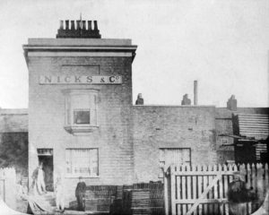 The Timber Yards were used by a number of different traders during their lifetime. Once such was Nicks & Co. [40]
Nicks & Co. are still trading in 2020 from their site on Canada Wharf. The adjacent image shows their first offices, the picture was taken in 1863. [41] Hugh Conway-Jones has written a short history of this company which appeared in the GSIA Journal in 2007. [40]

Typical view of the timber yards alongside the Canal. The view is taken looking North from Baltic Wharf towards the Docks. This is not a view of Nicks Timber Yard but shows the length of canal about 500 yards North. The access railway siding can easily be seen in the picture running from the bottom-left towards the top-right. Typical timer wagons stand on the siding [42]
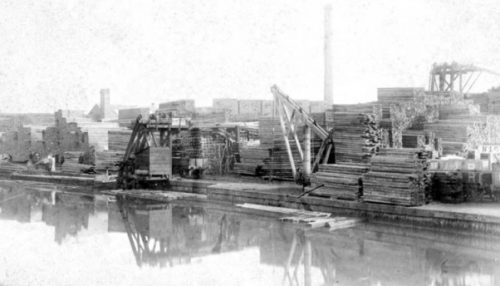
This smaller image comes from the 1880s and is included in an article by Hugh Conway-Jones published in the GSIA Journal, (c) Nicks& Co. Archive [40]. It shows Nicks & Co.’s frontage onto the Canal at Canada Wharf.

 Nicks & Co.’s yard was rail served, initially along the canal-side, as can be seen by the first image below. The image shows the unloading of timber at the canal-side from one of the 1940 shipments. [43]
There were also internal sidings and the next picture shows. The main feature of the image is the construction of a new chimney in 1916. The internal sidings of the yard a visible towards the bottom of the image. [44]
Griggs’ Timber yard was at the South end of the wharves close to the Bristol Road. It started operating in 1875 and is still in operation in 2020. [48]
Saw Mills were an integral part of the industrial development of Baltic Wharf and Canada Wharf. Two large concerns are marked on the OS Maps at the Southern end of the site.
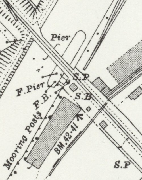 Rail access to all of these concerns was along the canal-side from High Orchard Yard, no connection seems to have been made to the Hempsted Branch when it was installed. All of the OS Map Series show a dis-connect (as in the adjacent extract) between the Canal-side lines and the Hempsted Branch,
The Hempsted Branch
The Hempsted Branch was a Midland Railway incursion into GWR territory. The two companies has reached a competitive truce which saw the Midland managing traffic on the East side of the Docks and the GWR operating on the West side of the Docks. Visit-Gloucestershire reports that the Hempsted Branch opened on 5th September 1898. [15] Colin Maggs says that, “The variously named New Docks, Tuffley, or Hempsted branch ran from Tuffley Junction (where the hitherto parallel MR and GWR divided to make their separate ways to Gloucester) to Hempsted Wharf. The branch opened to goods on 24 May 1900; a sub-branch, opened in 1913, served the gasworks. Another line crossed Monk Meadow where, until 1938, it linked with the GWR’s docks line. At Monk Meadow a dock and large pond for floating timber had been constructed west of the canal in 1891 and 1896 respectively. In 1969, the branch closed west of the gasworks siding and was shut completely two years later.” [22] Wikipedia supports the date Maggs has indicated for the opening of the line. [37] The Railway Clearing House Map of 1910 shows the Hempstead Branch on the bottom-left (Wikiwand) [38]
 25″ OS Map – the Hempsted Branch leaves the main line. [3] Its primary purpose was to proved the Midland Railway with access to the West side of the Gloucester and Berkeley Canal. The next few 25″ maps show its route up to the Canal Bridge.
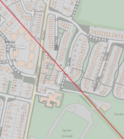 The ‘Know Your Place’ 2019 digitized maps [3] show the modern Podsmead Road at the hear of residential development. The old accommodation bridge which carried the Hempsted Branch over the road shown in the top-left of the 25″ OS Map above is long gone. Earlier OS Maps show the bridge in place supporting the line long before Podsmead Road was extended South under the line. The old branch was carried on an embankment which is also long-gone.

Looking Northwest along the line of the old branch (Google Streetview).  A little to the Northwest of Podsmead Road the branch broadened out into a series of sidings and at that point a ‘sub-branch’ turned away to the Southwest. [3]

An extract from EPW037842 – Britain From Above. The picture was taken in 1932 and shows the Gasworks at the centre of the image. The canal can be seen in the bottom-left of the image with Bristol Road (A38) running parallel to it and almost empty of traffic! The Gasworks sidings can be seen heading away North towards the Hempsted Branch which runs across the top of the picture [46]
Two further images appear in his second collection [21: p18-19]. The first shows 4F 0-6-0 No. 44264 in charge of a train of coal wagons heading along the Hempsted branch towards the Gasworks sidings in September 1965. [21: p18] The second is a view across the allotments which are centre-bottom of the first of the two map extracts above. [21: p19] The picture shows the 44264 returning, tender first, from the Gasworks with empties on the same day.
The gasworks were decommissioned in the early 1970s but it took around 40 years for the site to fully made safe. [46]
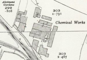 At the Northwest end of the sidings before the Branch passed under the Bristol Road ther was a further siding bearing away to the Southwest and a short stub-siding on the Northeast side of the running line. The first of these served Hempsted Wharf although it was divided from the Canal by Bristol Road (A38). The stub-siding served a chemical works.
And finally ……….
In order to build the Hempstead Branch the Midland Railway had to realign the A38 Bristol Road and build a substantial 3-arch bridge. This is the last significant feature before the branch crossed the Canal on a sing bridge.

The parapets of the bridge over the Hempsted Branch, still in place in 2019 (Google Streetview). Looking to the East from the A38 bridge over what was the Hempsted Branch. This picture was taken in 2019 (Google Streetview).
 Looking West along what was the Hempsted Branch towards the Canal. Joseph Griggs’ Timber yard is beyond the bridge parapet.
 A grainy extract from EPW037841 – Britain From Above (1932). The bridge carrying the A38 Bristol Road is highlighted. The Hempsted Wharf Sub-Branch and the Hempsted Branch are indicated. Both have wagons sitting on them. It is impossible to make out the Canal Bridge on this image. [49]
 Bristol Road Bridge in 2019 looking along the old Hempsted Branch to the Canal (Google Earth 3D).
 Looking East across the A38 from above Griggs’ Timber Yard in 2019. The three-arch bridge is hidden in the shadows created by the trees (Google Earth 3D)

The route of the Hemsted Branch as it crosses the Canal is shown by the red line on this image. The swing bridge has long been removed. The route on the far side of the canal is now a footpath (2020 – Google Earth -3D).
References
- http://lightmoor.co.uk/books/gloucester-midland-lines-part-2-south/L8665, accessed on 18th April 2020
- https://www.gloucestercivictrust.org/gmp19, accessed on 30th April 2020.
- https://maps.bristol.gov.uk/kyp/?edition=glos, accessed on 16th May 2020.
- https://britainfromabove.org.uk/image/epw041489, accessed on 18th May 2020.
- https://britainfromabove.org.uk/cy/image/epw024156?filter=new, accessed on 18th May 2020.
- https://www.britainfromabove.org.uk/en/image/EPW024171, accessed on 18th May 2020.
- https://www.britainfromabove.org.uk/image/eaw012211, accessed on 18th May 2020.
- https://www.britainfromabove.org.uk/en/image/EAW012204, accessed on 19th May 2020.
- http://www.britainfromabove.org.uk/en/image/EPW016965, accessed on 19th May 2020.
- https://maps.bristol.gov.uk/kyp/?edition=glos, accessed on 18th May 2020.
- https://www.britainfromabove.org.uk/image/eaw032295, accessed on 19th May 2020.
- https://www.britainfromabove.org.uk/en/image/EAW032296, accessed on 19th May 2020.
- https://maps.bristol.gov.uk/kyp/?edition=glos, (2019 Q2 Base Map) accessed on 19th May 2020.
- https://llanthonysecunda.org/entry/1951-map-of-gloucester-docks, accessed on 20th May 2020.
- https://glostransporthistory.visit-gloucestershire.co.uk/Railgloschur2.htm, accessessed on 15th May 2020.
- https://commons.wikimedia.org/wiki/File:Towards_Barton_Street_-_geograph.org.uk_-_556948.jpg, accessed on 20th May 2020.
- https://commons.wikimedia.org/wiki/File:California_Crossing_-_geograph.org.uk_-_556928.jpg, accessed on 20th May 2020.
- https://picclick.co.uk/BRW-GLOUCESTER-CALIFORNIA-LEVEL-CROSSING-SIGNAL-BOX-8×6-372549205436.html, accessed on 20th May 2020.
- https://www.gloucesterdocks.me.uk/gloucester/gloquays/outletcentre.htm, accessed on 20th May 2020.
- https://www.fieldingandplatthistory.org.uk/content/people/the_paul_regester_collection_under_construction/historical/historical, accessed on 20th May 2020. These Photographs have all been included here with the kind permission of the Fielding and Platt Heritage Group given by their webmaster, Nick Bancroft.
- Ben Ashworth; The Last Days of Steam in Gloucestershire A Second Selection; Amberley Publishing, 2013.
- Colin Maggs; The Branch Lines of Gloucestershire; Amberley Publishing, 2013.
- Gloucestershire Archives, Clarence Row, Alvin Street, Gloucester. GL1 3DW, at the time of writing the Archives are closed to public access because of COVID-19.
- https://www.gloucestershirelive.co.uk/whats-on/shopping/gallery/take-look-gloucester-before-gloucester-2874249, accessed on 21st May 2020.
- https://www.geograph.org.uk/photo/5073947, accessed on 22nd May 2020.
- https://www.flickr.com/photos/rpmarks/47043165292/in/photolist-2iw1cDs-2eF3w5L-2iSbTEv-2iSak2W-bgMxZD-b2UkcD-6Do9cE-n2prPv-zCeDt9-fQfWct-mGV1bu-5w34Ly-8jVbZd-dBj9vC-e5iZyC-A81ge9-Heyqxg-DF2MSq-5kWsVr-ubMRWb , accessed on 20th May 2020.
- https://www.flickr.com/photos/rpmarks/27064068069/in/photolist-2iw1cDs-2eF3w5L-2iSbTEv-2iSak2W-bgMxZD-b2UkcD-6Do9cE-n2prPv-zCeDt9-fQfWct-mGV1bu-5w34Ly-8jVbZd-dBj9vC-e5iZyC-A81ge9-Heyqxg-DF2MSq-5kWsVr-ubMRWb, accessed on 20th May 2020.
- https://www.flickr.com/photos/rpmarks/24726893176/in/photolist-2iw1cDs-2eF3w5L-2iSbTEv-2iSak2W-bgMxZD-b2UkcD-6Do9cE-n2prPv-zCeDt9-fQfWct-mGV1bu-5w34Ly-8jVbZd-dBj9vC-e5iZyC-A81ge9-Heyqxg-DF2MSq-5kWsVr-ubMRWb, accessed on 21st May 2020.
- https://www.flickr.com/photos/rpmarks/18500102482/in/photolist-2iw1cDs-2eF3w5L-2iSbTEv-2iSak2W-bgMxZD-b2UkcD-6Do9cE-n2prPv-zCeDt9-fQfWct-mGV1bu-5w34Ly-8jVbZd-dBj9vC-e5iZyC-A81ge9-Heyqxg-DF2MSq-5kWsVr-ubMRWb, accessed on 21st May 2020.
- https://www.flickr.com/photos/rpmarks/18504446345/in/photolist-ucb8dn-2iw1cDs-fQfWct-bgMxZD-b2UkcD-Heyqxg-DF2MSq-5kKUHy-9bP8qM-248dmH2-22b7ugq-ZPRrAD-ZkXMPF-R1aR62-afMbgv-jAhbFe-DyZNGz-DyZU8V-6Do9cE-Dj7tjT-ubMRWb-u9QhmL-e5iZyC-b2UjRF-tf8VQ5-mGV1bu-8N16He-8N15nT-uvZ7Ab-bxVUAw-aFEGBZ-7aWPNr-aSXm9V-5w34Ly-7oV8n1-FzqJaC-5kHusR-ArqK5s-7BHWHb-BByqpD-w7byw5-DF2J6Y-amVikV-AGEsMR-A3gMTE-yXNocm-zX9eUM-B8AemT-cDGMBN-8Wq2ZN, accessed on 20th May 2020.
- https://www.flickr.com/photos/rpmarks/4323145085/in/photolist-7A2fqe-bspaaJ-bkLKkq-6NiztG-baXECF-6bnAm9-6cU957-6bnzCJ-gZMCPq-6Do9JN-bJpUW2-6b7mHT-6gBeLr-5kHusR-dJcxXz-aSXm9V-7oV8n1-5kKUHy-9bP8qM-jAhbFe-bxVUAw-aFEGBZ-gZMJrM-5w34Ly-a39pHr-6Do9cE-dBj9vC-f47T7B-dJaAsP-edBv71-5nGQVw-dJaBea-5npTsX-bzbZKB-dexgKR-ak1hdU-8Xbor1-dV9aTq-b2UjRF-fQfWct-dNzsnN-bgMxZD-b2UkcD-b5yBDt-cDGMBN-amVikV-5kWsVr-d4oAN3-bFq8nK-e5iZyC, accessed on 20th May 2020.
- https://www.flickr.com/photos/rpmarks/37638234505/in/photolist-ucb8dn-2iw1cDs-fQfWct-bgMxZD-b2UkcD-Heyqxg-DF2MSq-5kKUHy-9bP8qM-248dmH2-22b7ugq-ZPRrAD-ZkXMPF-R1aR62-afMbgv-jAhbFe-DyZNGz-DyZU8V-6Do9cE-Dj7tjT-ubMRWb-u9QhmL-e5iZyC-b2UjRF-tf8VQ5-mGV1bu-8N16He-8N15nT-uvZ7Ab-bxVUAw-aFEGBZ-7aWPNr-aSXm9V-5w34Ly-7oV8n1-FzqJaC-5kHusR-ArqK5s-7BHWHb-BByqpD-w7byw5-DF2J6Y-amVikV-AGEsMR-A3gMTE-yXNocm-zX9eUM-B8AemT-cDGMBN-8Wq2ZN, accessed on 20th May 2020.
- https://www.flickr.com/photos/rpmarks/18717311438/in/photolist-ucb8dn-2iw1cDs-fQfWct-bgMxZD-b2UkcD-Heyqxg-DF2MSq-5kKUHy-9bP8qM-248dmH2-22b7ugq-ZPRrAD-ZkXMPF-R1aR62-afMbgv-jAhbFe-DyZNGz-DyZU8V-6Do9cE-Dj7tjT-ubMRWb-u9QhmL-e5iZyC-b2UjRF-tf8VQ5-mGV1bu-8N16He-8N15nT-uvZ7Ab-bxVUAw-aFEGBZ-7aWPNr-aSXm9V-5w34Ly-7oV8n1-FzqJaC-5kHusR-ArqK5s-7BHWHb-BByqpD-w7byw5-DF2J6Y-amVikV-AGEsMR-A3gMTE-yXNocm-zX9eUM-B8AemT-cDGMBN-8Wq2ZN, accessed on 21st May 2020.
- https://en.wikipedia.org/wiki/Midland_Railway_1528_Class, accessed on 24th May 2020.
- https://commons.wikimedia.org/wiki/File:Gloucester_Docks_geograph-2224398.jpg, accessed on 19th May 2020.
- https://www.tewkesburydirect.co.uk/times-gone-by, accessed on 20th May 2020.
- https://en.wikipedia.org/wiki/Bristol_and_Gloucester_Railway, accessed on 25th May 2020.
- https://www.wikiwand.com/en/Gloucester_railway_station, accessed on 25th May 2020.
- https://en.wikipedia.org/wiki/Gloucester_Railway_Carriage_and_Wagon_Company, accessed on 25th May 2020.
- Hugh Conway-Jones; Nicks & Co. Long Established Timber merchants of Gloucester; Gloucestershire Society for Industrial Archaeology (GSIA) Journal for 2007, p3-13. Found online at https://www.gsia.org.uk/reprints/2007/gi200703.pdf, accessed on 25th May 2020.
- https://nickstimber.co.uk, accessed on 25th May 2020.
- https://www.gloucestershirelive.co.uk/news/history/gallery/day-docks-caught-fire-gloucesters-3960358, accessed on 25th May 2020.
- https://www.facebook.com/Nickstimber.co.uk/photos/a.1053087591401414/1536323183077850/?type=3&theater, accessed on 25th May 2020.
- https://www.facebook.com/Nickstimber.co.uk/photos/a.1053087591401414/1536323189744516/?type=3&theater, accessed on 25th May 2020.
- https://sites.google.com/site/gloucestershirerailwaymemories/home/train-services/31-october-1964, accessed on 27th May 2020.
- https://www.nationalgrid.com/sites/default/files/documents/25492-Gloucester%20case%20study%203pp.pdf, accessed on 27th May 2020.
- https://www.britainfromabove.org.uk/image/epw037842, accessd on 27th May 2020.
- https://www.griggstimber.co.uk, accessed on 27th May 2020.
- https://britainfromabove.org.uk/en/image/EPW037841, accessed on 27th May 2020.
- https://www.britainfromabove.org.uk/image/epw050778, accessed on 28th May 2020.
- Ben Ashworth; The Last Days of Steam in Gloucestershire; Amberley Publishing, 2009.



Hello Roger..
However, there is one minor error which you might like to correct.
It is the Early 21st century view looking South across the location of California Crossing.
The High Orchard Branch crossed the A430 at a much sharper angle, as many a cyclist will attest.
Also the Tuffley Loop was along the grass on the left of your photo.
The line went to the left of the clump of trees on the left of the photo.
I have drawn (very poorly) in blue the approximate alignments in the photo below.
[Fig 36a.jpg]
Regards
Roger Smith
Hi Roger
Thanks for the heads up.
I cannot find the file. Please could you try sending it again, or by email.
Thank you and best wishes.
Roger
Thanks foor writing