Category Archives: Ireland

The West Clare Railway – Part 3 – Lahinch to Miltown-Malbay

The Line of the West Clare Railway from Lahinch to Miltown-Malbay

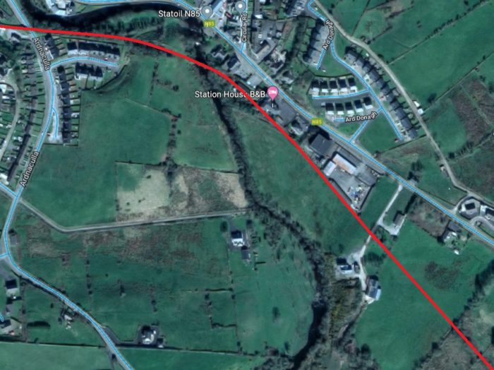
We recommence our journey at Lahinch Station. The satellite image below was provided close to the end of the last post in this series.
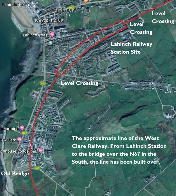
This satellite image allows the whole of the Lahinch area to be included. The area in the curved red box in the station area and is represented below in a sketch plan.
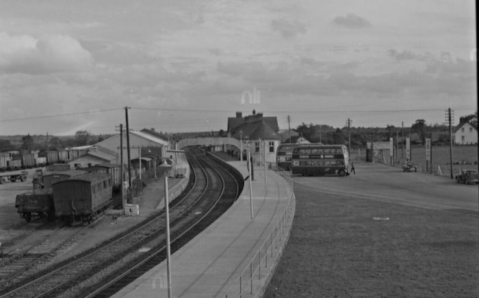
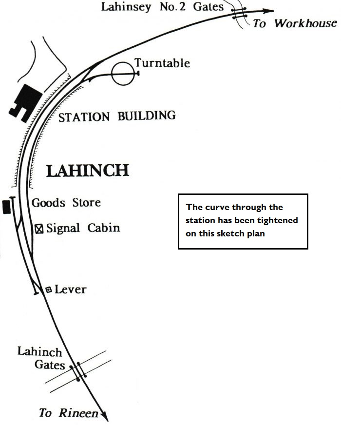
Lahinch Station. [1]
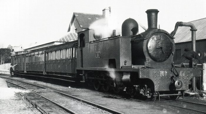
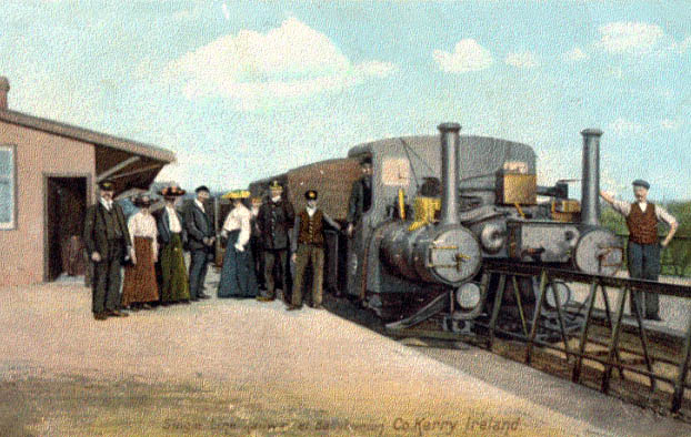
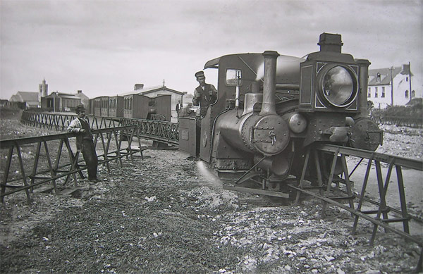
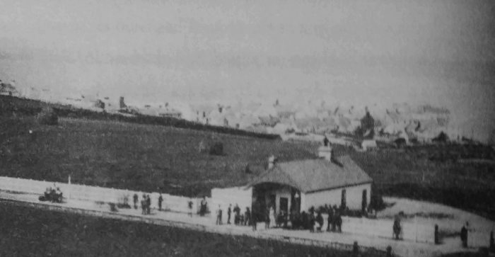
Lahinch Station around the turn of the 20th Century, with the village beyond. [2]
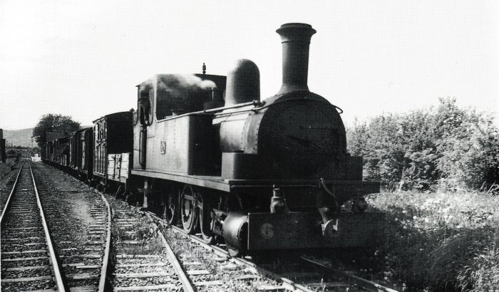
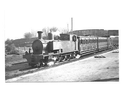
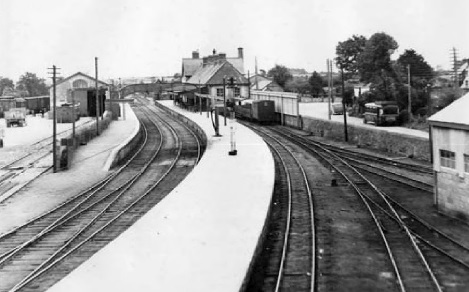
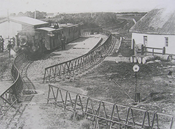
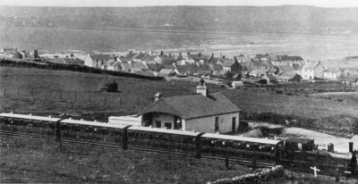
A train from Kilkee waits at Lahinch on its way to Ennis. [5]
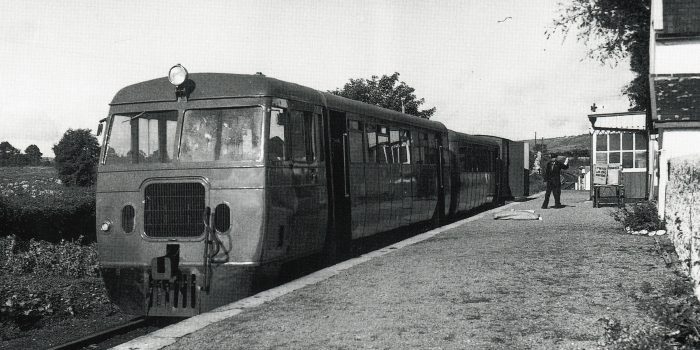
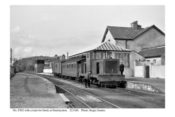
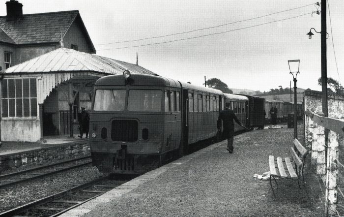
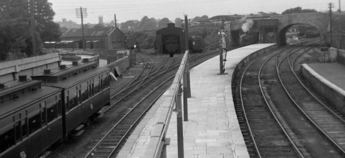
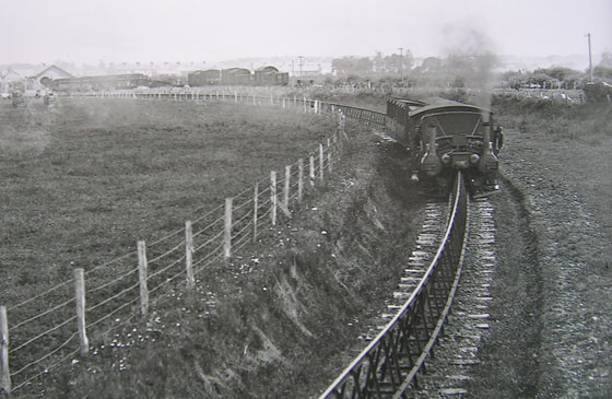
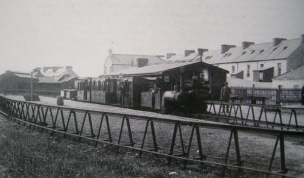
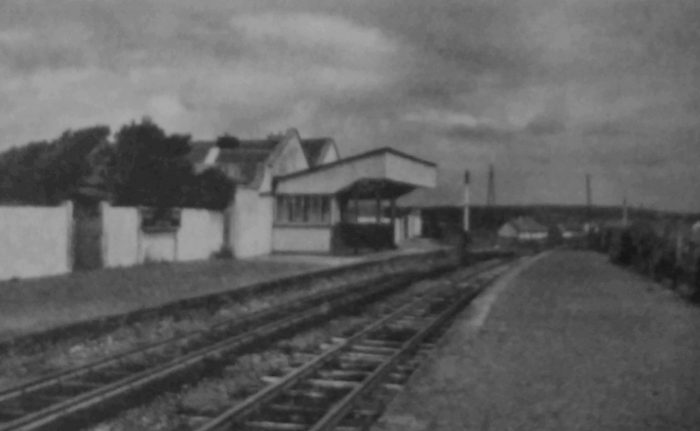
Lahinch Station in 1961. [2]

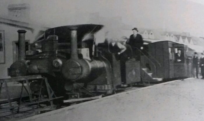
As the above pictures show Lahinch Station developed over the years.

Lahinch or Lehinch (Irish: An Leacht or Irish: Leacht Uí Chonchubhair, meaning “The Memorial cairn of O’Connor”) is a small town on Liscannor Bay, on the northwest coast of County Clare, Ireland. It lies on the N67 national secondary road, between Milltown Malbay and Ennistymon, roughly 75 kilometres (47 mi) by road southwest of Galway and 68 kilometres (42 mi) northwest of Limerick. [4]

The town became a popular tourist destination on the Atlantic coast and close to the Cliffs of Moher.
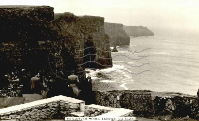
The Cliffs of Moher. [6]

Lahinch developed from having just a few cabins in the eighteenth century to having a population of over one thousand people in 1835. However, no significant development took place in the early nineteenth century as the sea front continued to take a severe battering from the Atlantic gales. [3] It was not until later in the century that the infrastructure of the town developed and it became a seaside resort following the opening of the West Clare Railway in 1887. In 1883, the town was struck by a severe storm which destroyed the sea wall and promenade and damaged many buildings. Local governor William Edward Ellis oversaw the repair work which followed and the construction of a new sea wall and promenade were inaugurated by the wife of the Viceroy, Lady Aberdeen, in July 1893. [14]

Lahinch’s popularity and fame depend on two features. First and foremost is the mile-long beach of golden sand stretching along in front of the village, promenade and sandhills. With the growing popularity of sea bathing and the arrival of the West Clare Railway in 1887, people began to arrive in unprecedented numbers. The village’s secondary claim to popularity is its Golf Club. [3]

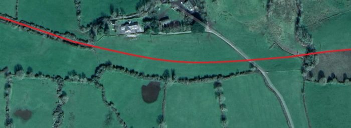
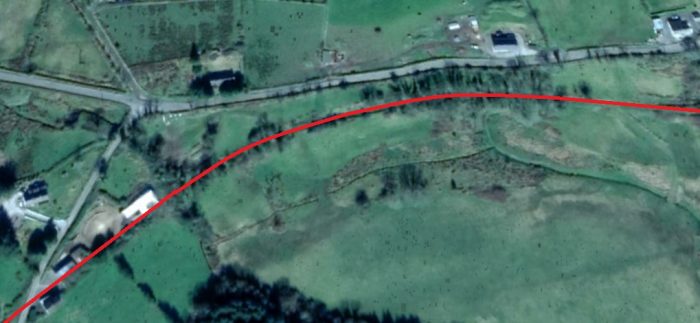
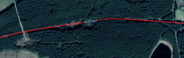
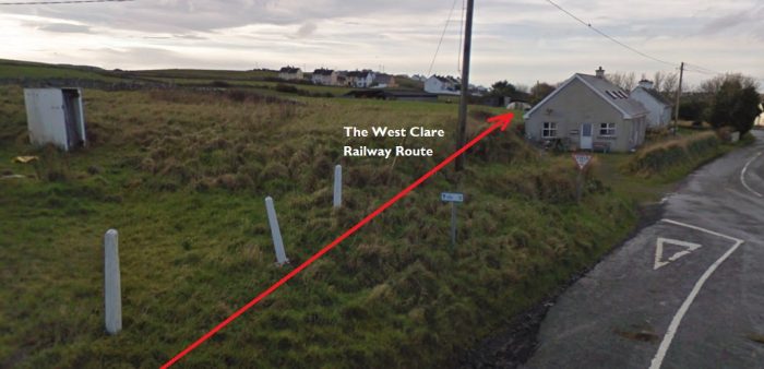
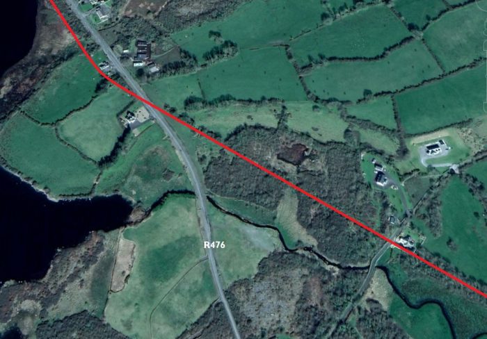
There was a short ascent out of Lahinch, 1 in 193, across Gregg level crossing, just beyond Mile Post 21 and through Coffey’s Bridge (No. 41) which carried a laneway over the line. With Moy Bay on the west the line crossed over the Lahinch-Miltown Road twice, first at Major’s Bridge (No. 42) and secondly at Crag Bridge (No. 43).

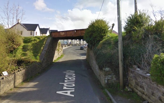
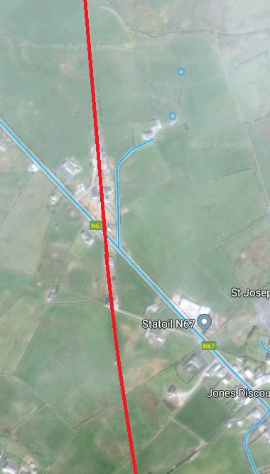
South of Lahinch Station the route described above is now hidden under new development as far as Major’s Bridge (or perhaps it is Crag Bridge). This bridge is the first evidence we can see of the route of the line South of Launch. It spans the modern N67 road.
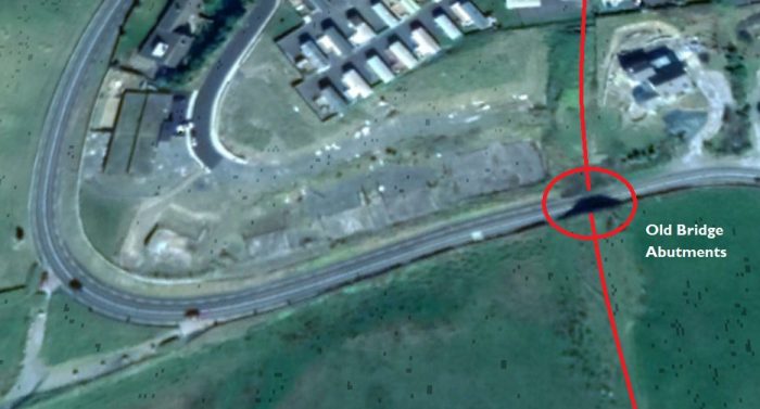
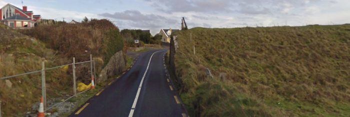
The line was carried on an embankment to the South of Lahinch. Major’s Bridge (see below) has lost its superstructure but it was no doubt of very similar construction to the next structure which can be seen and the bottom of the adjacent satellite image, Crag Bridge (see below). [7]

Crag Bridge (see below) can be seen in the Google Streetview images below. The first picture is taken from the East looking towards the coast. The second photograph is taken from the West  looking back along the N67 towards Lahinch.

In both these images the bridge is far more overgrown than it would ever have been while in use before the closure of the railway line.

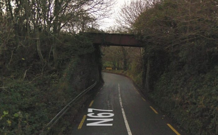
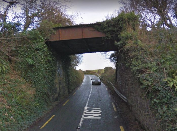
Patrick Taylor’s choice of names for these two bridges [7] is unlikely to be correct. Edmund Lenihan suggests that the first bridge encountered is Crag Bridge and the second, Major’s Bridge. He comments: “Quite unexpectedly we were at Crag Bridge – or rather, where it had been, for the metal deck which spanned the Milltown road is one of two that have been removed. Before climbing down to the road, we paused for another look at the panorama stretching away southward. The line, embanked all the way, loops off to the southeast like some monstrous snake on its way towards the rugged scenic area known as ‘The Major’s Wood, beyond which the ground rises into the dark ridge of Black Hill, following the coast into the distance towards Rineen.” [8]

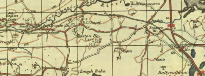
In the North Clare Bridge Survey, the second bridge is recorded as Calluragh South Bridge as below. It’s proximity to Moy House suggests that this much have been Major’s Bridge. [11]
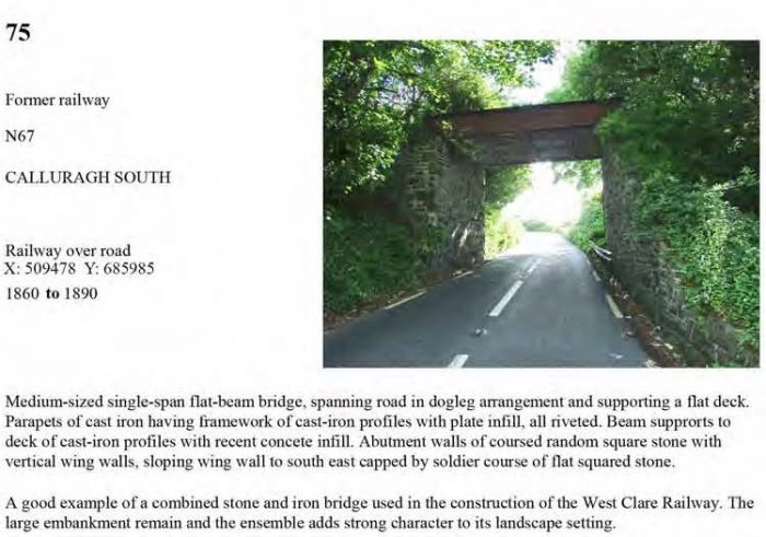
This length of the line was exposed to the strongest Atlantic weather. So exposed that it was the scene of a derailment on 24th December 1912, caused by a freak wind. [7] Edmund Lenihan, writing in the late 1980s, says: The sizeable cutting which succeeds this long clear stretch has only one claim to fame, so far as I am aware. Here, on a (lay of fierce storm almost eighty years ago, several carriages of an unladen special from Kilrush were derailed — literally blown off the track. [12]

That cutting included Major’s Road Bridge and Major’s River Bridge over the River Moy. Edmund Lenihan comments: “Moy House, white and turreted, [is] situated on rising scenic ground overlooking the coast just west of the Moy River. Built by the Fitzgeralds, landlords of the area, in the early nineteenth century, it was later bought by Major George Studdert, whose descendants lived in it until the 1930s. He lent his title to the fine railway bridge which crosses the river a short distance away. Even yet it is known as `The Major’s Bridge’ and is, with Toloughlahan and Cullenagh, one of those that should be preserved for posterity. The view from it is spectacular. The public road dips into the wooded valley of the Moy River here, and the coincidence of road and rail bridges only yards apart makes this a memorable place.” [12]

Sadly the wooded valley of the River Moy is now choked with blackthorn and the river bridge is, in the 21st Century, seemingly inaccessible.
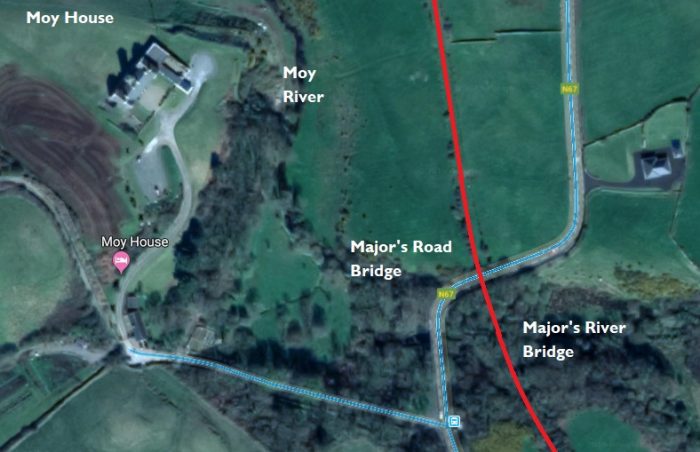
Moy House is now a Georgian country house hotel about 3 kilometres (1.9 mi) south of Lahinch near the village of Moy. Originally set in 15 acres of woodland on the River Moy, it was built in the mid-18th century as the holiday home of Sir Augustine Fitzgerald. Later it was sold to Major Studdert, who gave his name to the bridges over the road and the river on the West Clare. The house was vacant for 10 years, but was purchased by Antoin O’Looney who undertook a three year restoration of the property. It was voted Country House of the Year by Georgina Campbell’s Ireland in 2003. [9][10]
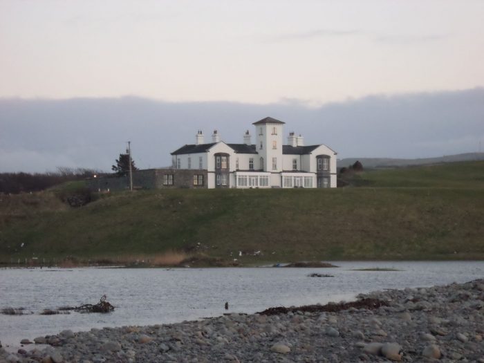
Moy House from the sea. [10]
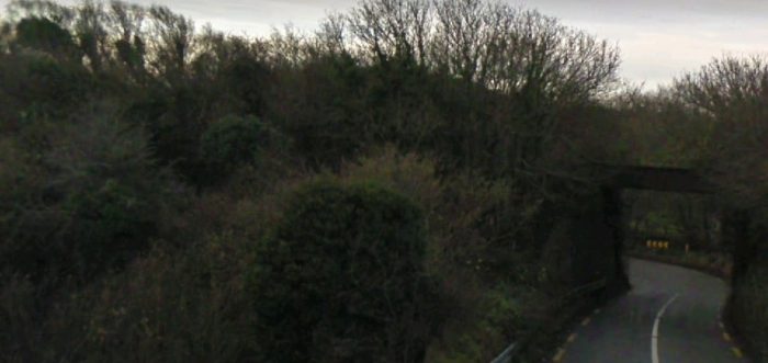
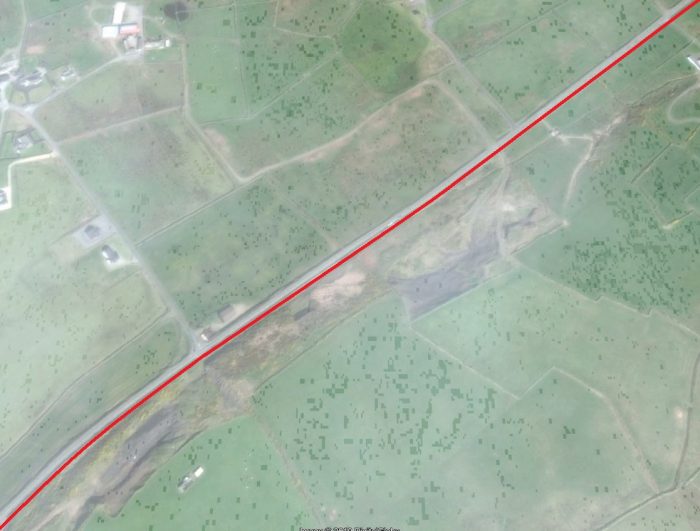
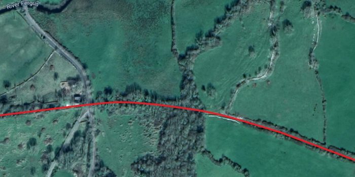
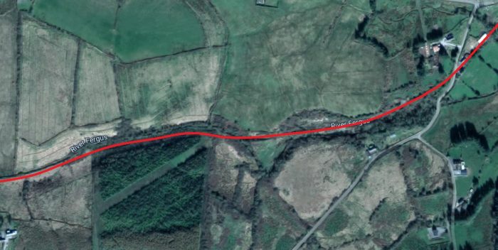
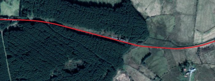
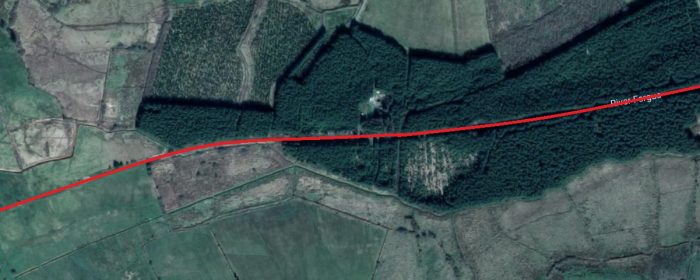
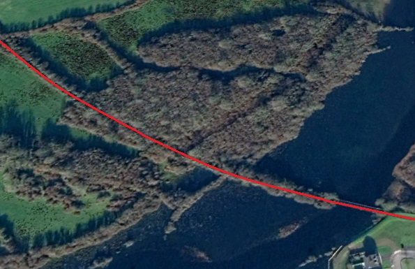
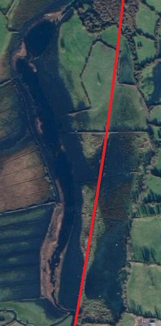
South of the second bridge, the line crosses the Moy River and curves slightly to the East before swinging  gradually round to the West. The adjacent satellite image and the one directly below show the route.

The location of the Moy River Bridge was adjacent to Major’s Road Bridge. The picture above shows that the river bridge is amidst  heavy blackthorn growth.

Both the road and the railway followed the line of least resistance as they climbed to cross Black Hill, travelling first along its flank and heading towards the sea.

Edmund Lenihan found the ground along the route from the river to Moy Bridge almost impassible in the 1980s. 
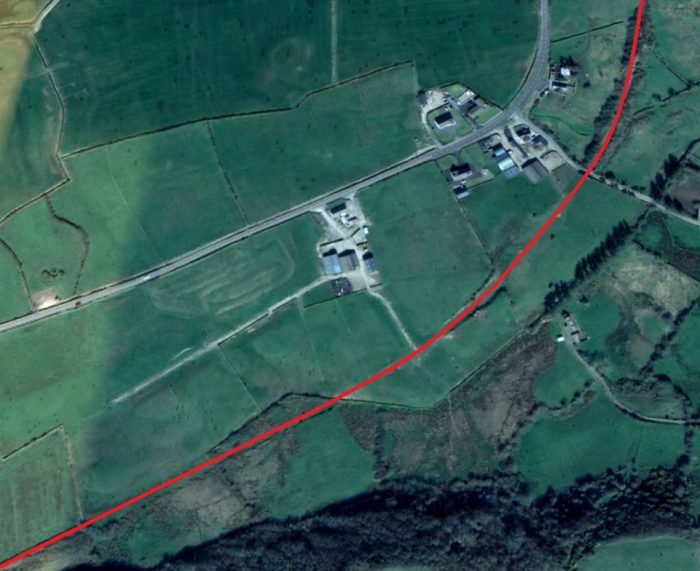
Moy Bridge another structure to have had its steel/wrought-iron deck removed. Headroom was no doubt the issue here. Edmund Lenihan says: “The metal deck of Moy Bridge, like the one at Crag, has been removed. Only the stone abutments remain. The reason probably is that it was a particularly low structure, with headroom of no more than 10 feet — hardly high enough to let modern cattle trucks pass. This was also known as Hanrahan’s Bridge, and was made a halt in October 1958 — the last halt, in fact, to be instituted before the closure of the system.” [13]

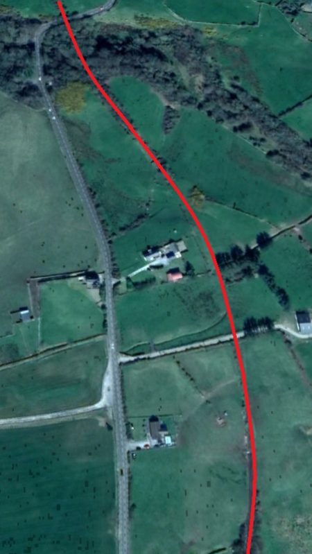
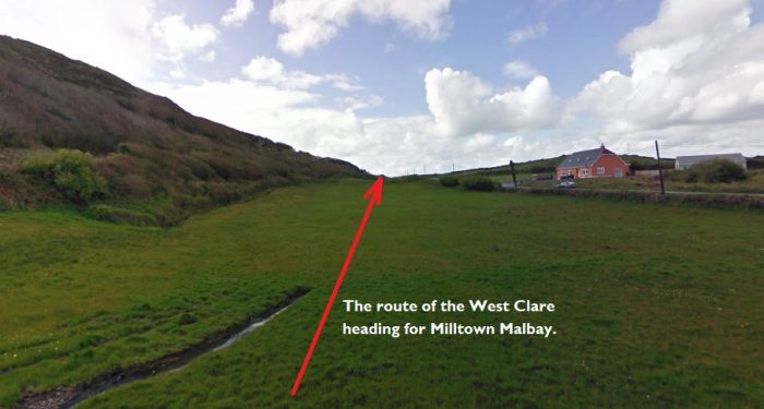
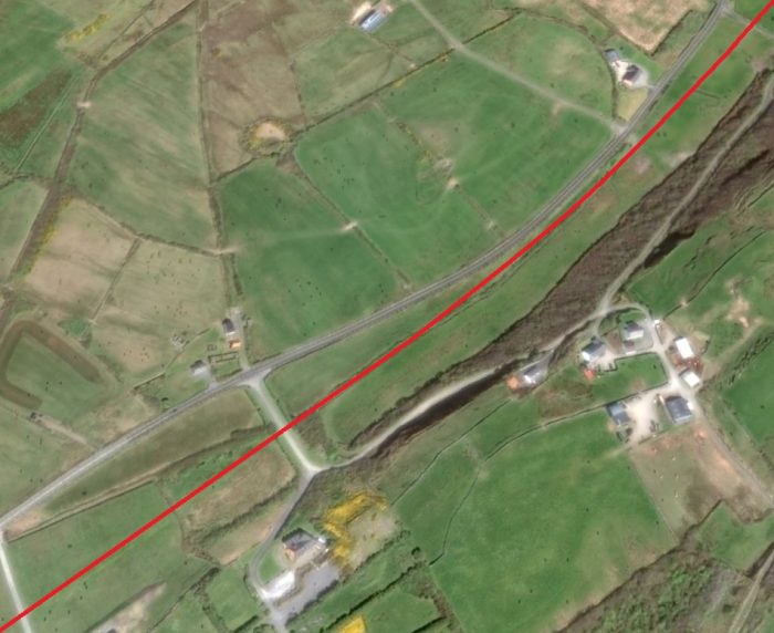
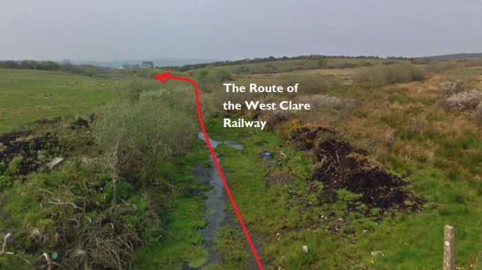
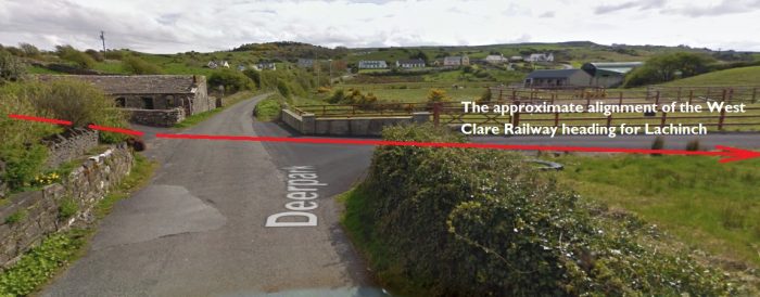
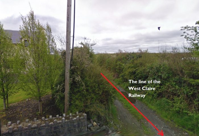
From Moy Bridge Lenihan talks of the line turning southwestward “more or less paralleling the Miltown road at a distance of never more than 500 yards for the next mile or more, until they swing together again halfway to Rineen school house, whence they curve round the western edge of Drummin Hill and on south to Miltown.” [13]
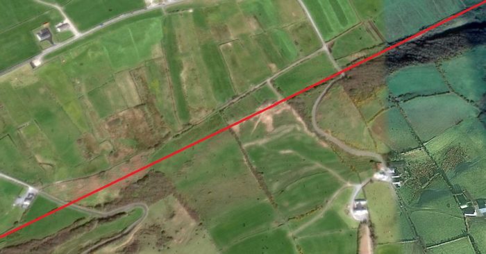
The picture below is taken from Google Streetview and shows the line of the West Clare at the location of the first road (to the right of the image) shown on this satellite image.
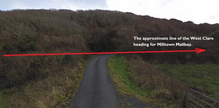
Miltown is a mere 2 miles from here, but there is still much to encounter on the route of the railway before Miltown is encountered. Edmund Lenihan again: “We left Moy Bridge behind, and framed by the V of the cutting beyond lay the wood we had seen from Crag Bridge as a mere smudge along the side of the hill. As we came closer we saw why it is called the Black Hill: the ‘wood’ consists almost wholly of blackthorn, flattened into the steep hillside by the sea wind, thereby giving the impression of a solid mass. The visual effect created at this time of bare branches is startling. As we passed into the townland of Moybeg, the line had almost swung under the hill, and the distance between us and the wood continued to narrow. It is rough land and very neglected-looking. Water, more than anything else, impresses itself on the eye and ear: sodden fields left and right, a hidden cascade tumbling down somewhere through the wood, and the bay off to the west beyond the road. It is no place for the fainthearted traveller. Where line and wood eventually met we found our way barred by a stout fence and beyond that a jungle. We were soon floundering in bog and marsh.” [15]
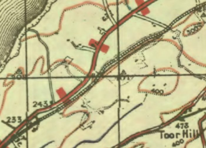
The line follows the gentlest possible path rising seemingly gradually through the contours and as a result drifts back towards the line of the road as this 1940s OS Map shows. The grade was however really quite steep for the underpowered locomotives of the West Clare Railway.

Lenihan continues his late 1980s perambulation: “All this time the only constant thing was the hill, overlooking us severely to the left; the rest was a mixture of inaccessible thickets followed by the odd patch of reclaimed land. Among the stones at three different places we found chunks of yellow scorched brick and knew we were still on target. These were burned-out fire-bricks from the fire-boxes of the steam locomotives, dumped here with ash and other debris as packing for the sleepers.They were a useful guide to us on several occasions in ground that would have been otherwise featureless.” [16]

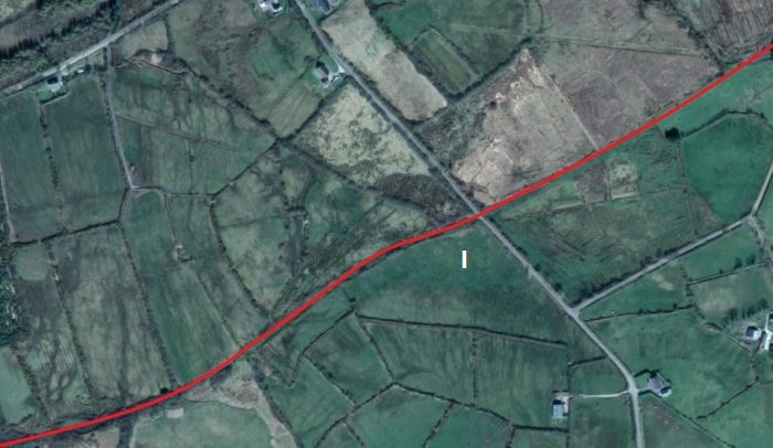
“When the line began to rise, it did so gradually at first over 500 yards or so, but then steeply. It is so straight and grown in by hazel up along the flank of the hill that we had to pause every so often in order to check our progress by looking through the branches, out towards the bay.” [17]
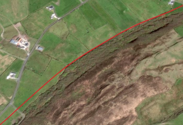
The un-gated crossing on the minor road at the bottom left of this image is shown in the images below.
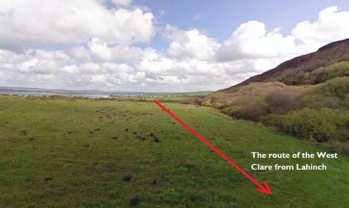
The un-gated crossing close to the centre of this image is the site of the next picture looking forward along the line.
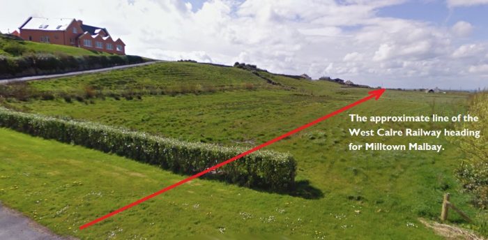
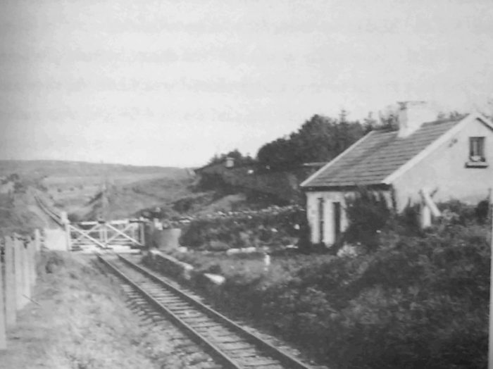
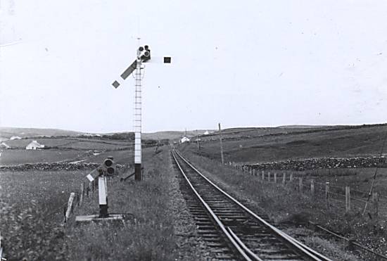
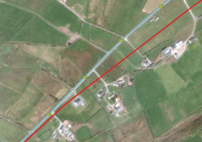
Patrick Taylor’s comments about this length are more succinct than those of Edmund Lenihan: “At Mile Post 22.25 Hanrahan’s Bridge (No. 45) (or Moy Bridge in earlier days) became a railcar stopping place on 1st October 1958 (the last one created before closure). The line, already ascending at 1 in 96 steepens with sections of 1 in 63/64/55 and 52 up Rineen Bank on the flank of the Black Hill – a formidable climb in steam days. Moymore No. 1 and No. 2 level crossing were in this section – close together at Mile Post 23. and Rineen Halt was at m.p. 24.5, opened on 5th May 1952. A ballast siding was once in operation here and in the earlier days trains stopped on request. ” [7]
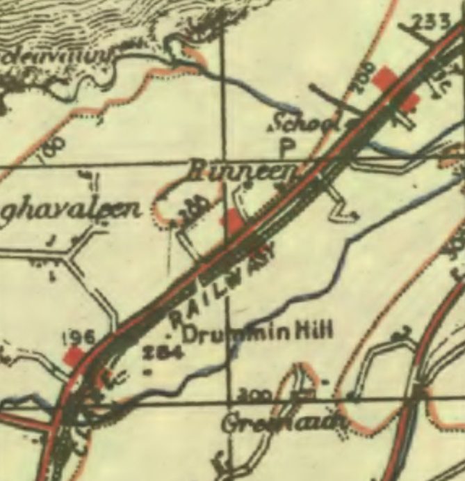
The road and railway ran immediately next to each other for some distance  through Rinneen.
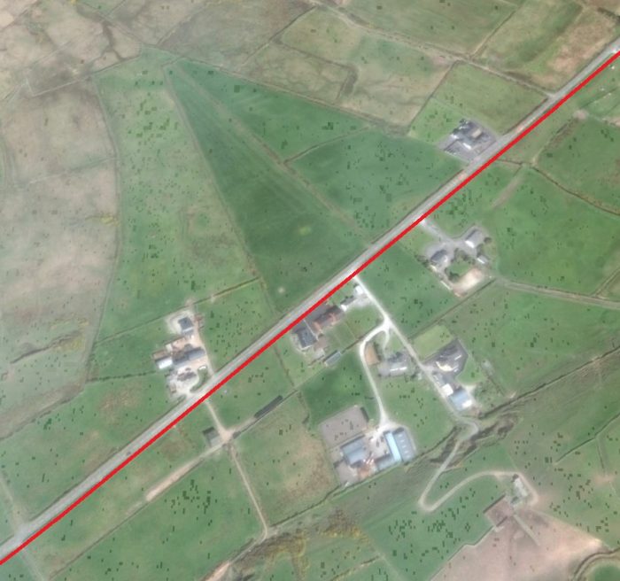
Again, Patrick Taylor comments: “The line continued by the side of Rineen Hill quite adjacent to the main Lahinch-Miltown public road. which ran parallel with the railway for three miles and at some points was only separated by a stone wall. On this stretch there were two bridges, Rineen over a stream, and Downes (No. 51) which crossed the line at Ballinaphonta, before Miltown-Malbay was reached at Mile Post 27.” [7]

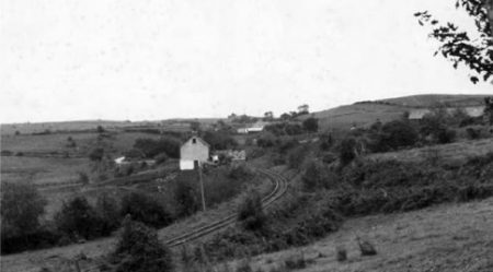
Lenihan takes us on towards Rineen: In the next mile or so, “to Rineen school, there is a dramatic improvement in the quality of the holdings and consequently far more houses. Most of them are just one field in from the road, which means that the railway ran by their front doors. Perhaps this is why, in May 1952, a halt was opened a few hundred yards to the Lahinch side of the school.” [18]
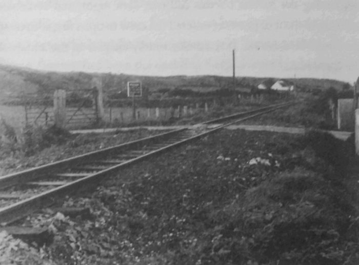
Rineen Crossing and Halt in 1953, (c) IRRS. [18]

“Across the road from the school is as good a place as any to get an accurate impression of the condition of the line. Look back – it is there; look forward – nothing. For as far as we were able to see all had been swept away. … Under Drummin Hill, which in places falls cliff-like to the road, railway and highway were separated by only a stone wall, a short way beyond where the 25th Mile Post was located.” [19]

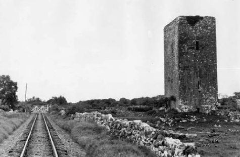
Below the railway along this length is a small stone monument – a plaque commemorating the Rineen ambush, one of the best-known actions of the War of Independence in Clare. 
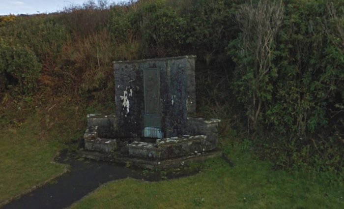
From this hill, on 22nd September 1920, a party from the 4th battalion of the IRA attacked a truck bringing police from Miltown to Ennistymon. In the ensuing fight, which was soon joined by British reinforcements, six police were killed with no losses on the part of the attackers!

The consequences for Lahinch, Miltown and Ennistymon were drastic. “Tne orgy of reprisals — burnings and shootings — released against them still remains vivid in the minds of old people. At 7 p.m that night the military invaded Miltown, burning, looting and smashing windows. In the small hours of the morning, when it seemed as if the worst was over, the Tans arrived from their depredations in Ennistymon and Lahinch, and joined by the local RIC they continued the arson, theft and shooting until the following morning. It was a night’s work that destroyed for ever any shreds of confidence that the people of Kilfarboy might have retained in the forces of the Crown.” [20]

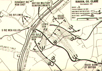
The form/layout of the ambush is illustrated in the sketch plan above. [22]

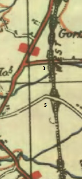
Travelling on, the line has all but been obliterated beyond the Bridge at Rineen which is shown in a sketch (c) M. Lenihan in Lenihan’s book. [21]
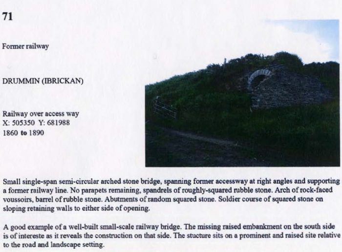
The North Clare Bridge Survey calls this bridge Drummin (Ibrikan) Bridge. [11]
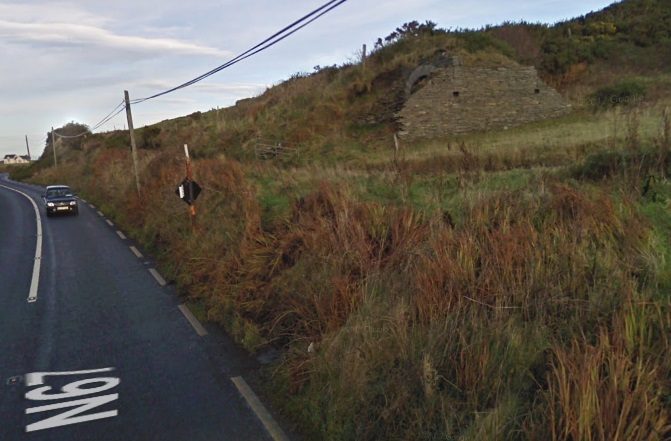
The same location, above, in a Google Streetview image from December 2009.

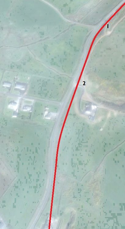
The momument is at location ‘1’ on the adjacent satellite image, the bridge is at location ‘2’.

The bridge, says Lenihan, is the “most elegant stone-arched crossing remaining on the line today. All its facings and the underside of the eye are of West Clare stone, but it is beginning to deteriorate, probably because of damage done by machines when the bank on its southern side was being cut away. It cannot survive long even in its present condition unless some restorative action is soon taken. [21]

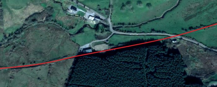
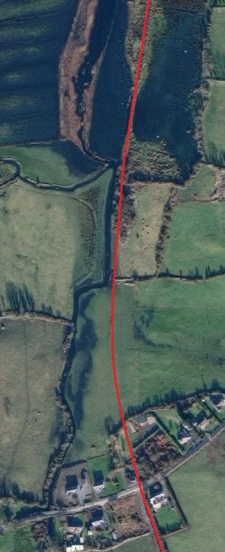
As can be seen on this satellite image and the OS Map from the 1940s, a little way south of the bridge the road and railway separate.

It is very difficult to pick out the line of the railway on Google Earth and it appears to have been just as difficult to follow the line in the late 1980s. Edmund Lenihan comments that a very broken section followed: “with a filled-in cutting, a house built on the line and farm sheds surrounding a second cutting.” [23]

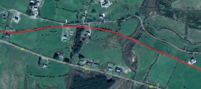
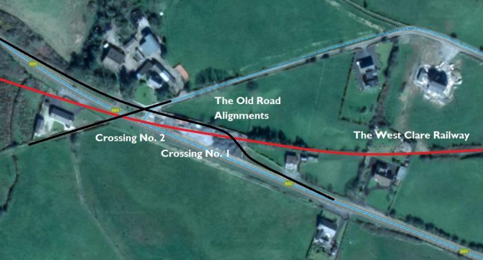
From here, it appears that the line ran in a straight line to Miltown Station. Lenihan says: “We emerged into not only the flat prospect of Fintramore but also an unexpected blaze of wintry sunshine. It cheered us, as did a clear view of the line for over half a mile, embanked all the way across the low bare fields. Off left, the spire of Miltown Church needled the sky, showing us how near we were to the terminus of the West Clare, while a bridge ahead served as a marker of our progress. Just beyond the location of the twenty-sixth milepost, a cattle-pass, 200 yards out, is still entirely intact [location ‘4’ below], but we had eyes only for the bridge [location ‘3’ above and below] and the view around.” [23]
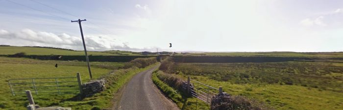
“At the bridge, [location ‘3’] we were a little surprised to find the metal deck still in place, but this is probably only because the road which runs underneath does not lead to anywhere of great significance and traffic is not heavy. Though in the town-land of Drummin, it was known as Rineen Bridge.” [23] It is shown below in its listing on the North Clare Bridge Survey. [11]
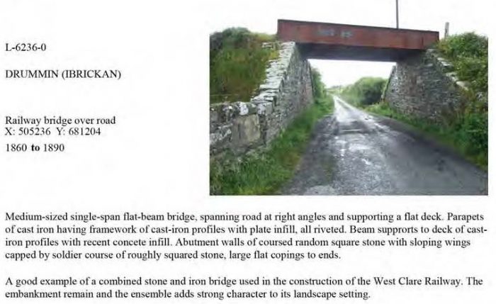
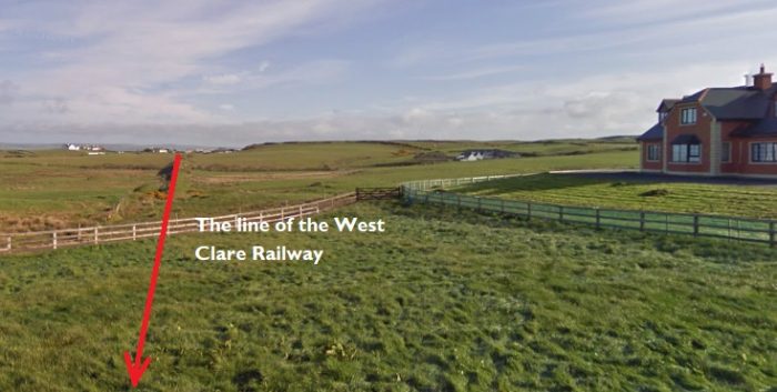
Looking back from location ‘5’ on the 1940s OS Map above, the embankment is visible in the distance under the red line showing the route of the railway. The record from the North Clare Bridge Survey below, shows the infilled bridge at location ‘5’. [11]
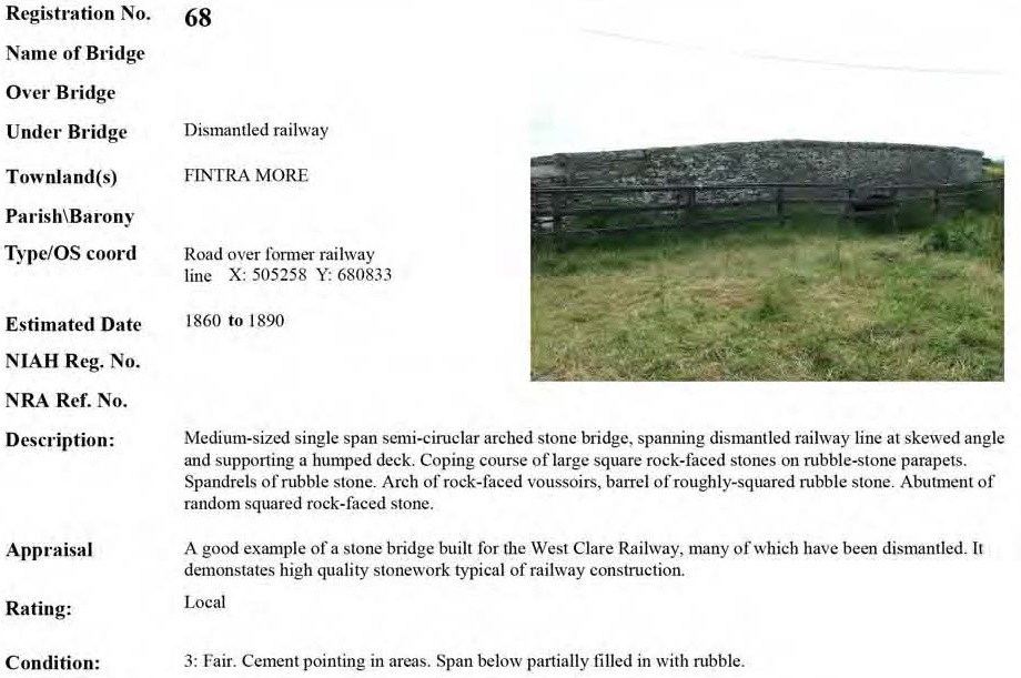
The next image is taken from the single track road carried by Fintra More Bridge. The view looks South towards Miltown.
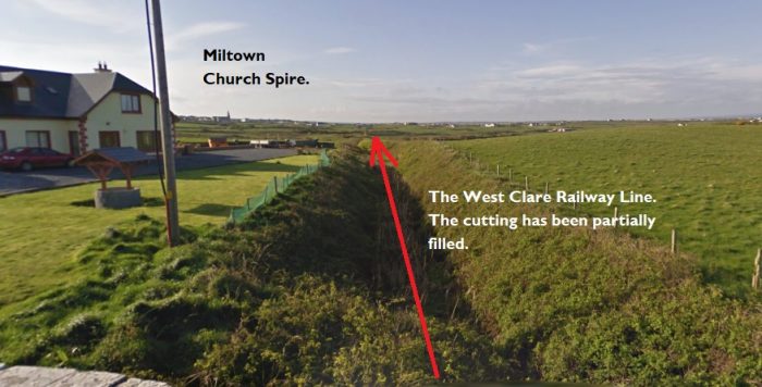
The partially-filled cutting above clearly shows the line of the railway under the road bridge at location ‘5’. Miltown church spire can be seen on the horizon. Lenihan refers to this as Downes’ Bridge which he says is a “stone-arched span carrying a by-road over the line.” [23]

South from this point the line crossed two streams and a cattle underpass before reaching another highway. Lenihan describes one of these valleys like this: “But now occurs one of those folds in the land which in extent are not large but which possess a beauty that has nothing to do with size alone. A small river flows here a full 25 feet below the level of the surrounding little hills, and it was this space that the builders of the line had to contrive a crossing for. That they succeeded admirably is unquestionable, and far from spoiling the beauty of this secluded place, their well-proportioned embankment and bridge lend it a light touch of order and symmetry. It is well worth a visit, though I suspect that few people know about it, near and all as it is to the town.” [23]

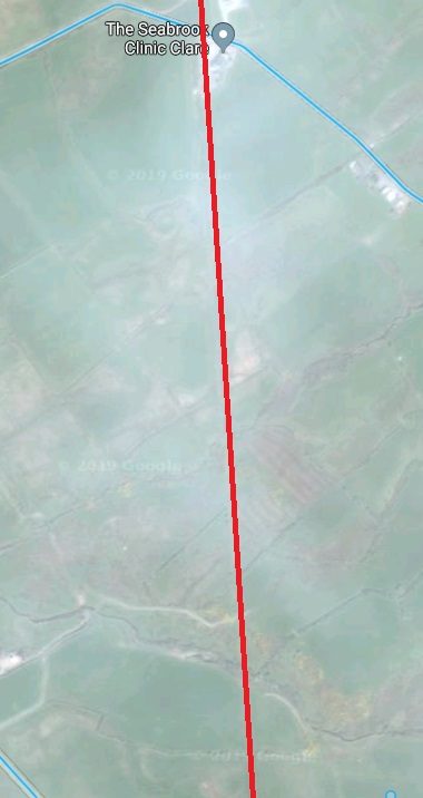
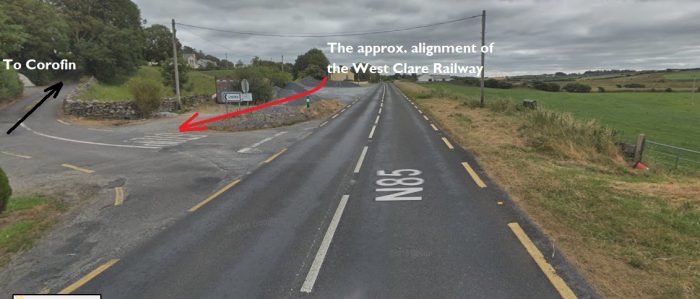
The satellite images provided by Google are relatively poor quality along this section of the line. The streams can only just be made out on the adjacent image. The highway is the erstwhile N67 which fled west from the line earlier in the journey. It is highlighted by the blue line on the satellite images – at the bottom left of the first and entering from the left on the second.

The route of the line either side of the N67 has been heavily built over. The properties built are all domestic dwellings. The OS Map from the 1940s shows road and railway crossing (below) at what appears to be an at-grade crossing rather than a bridge.

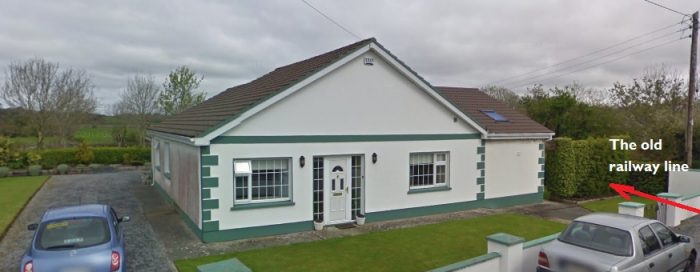
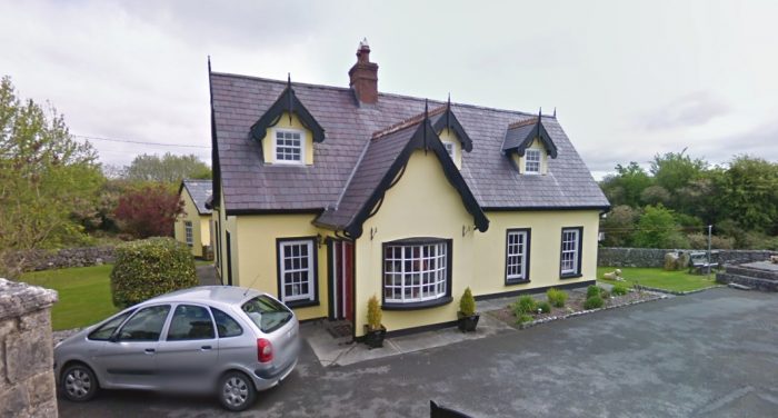
Pictures from the 21st Century seem to confirm this. The first photograph below looks back along the route of the line towards Lahinch. The private driveway is roughly along the line of the old railway.

The private house is what was once the old railway station of Miltown-Malbay. In the 21st century this has been refurbished as a home.

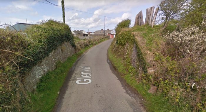
The station itself was on the North side of the N67. The second picture below takes a better look at the buildings and the old station canopy is clearly seen in the image.
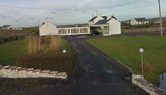
The view back towards Lahinch from the N67 in Miltown. The picture was taken from Google Streetview.
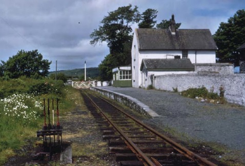
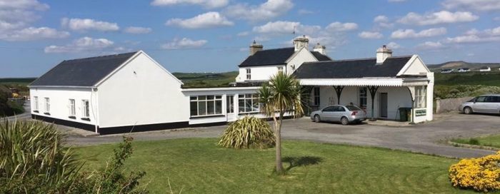
The old station layout is clearer in this image. [25]
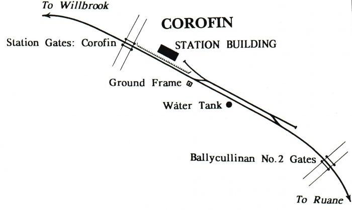
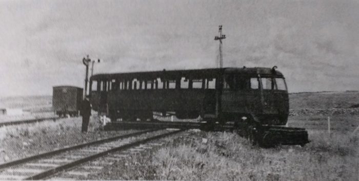
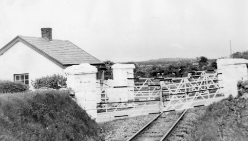
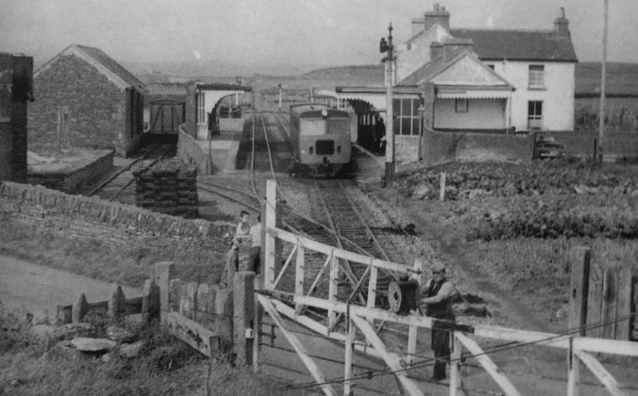
The station while still in use with the road which is now the N67 in the foreground with the crossing gates being opened to allow the passage of the railcar travelling South. The station track layout is also clear in this image and is reproduced as a sketch by Patrick Taylor below. [24]
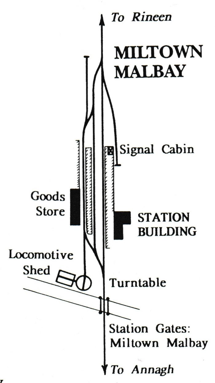
The rail layout at Milotown Malbay. [1]

We finish this part of the journey here in Miltown-Malbay.

References

  1. Patrick Taylor; The West Clare Railway; Plateway Press, 1994, p48.
  2. Edmund Lenihan; In the Tracks if the West Clare Railway; Mercier Press, Dec. 2008, p130-136.
  3. http://www.clarelibrary.ie/eolas/coclare/places/lahinch_history.htm, accessed on 15th April 2019.
  4. https://en.wikipedia.org/wiki/Lahinch, accessed on 17th April 2019.
  5. http://www.schmalspur-europa.at/schmalsp_87.htm, accessed on 17th April 2019.
  6. https://www.postcardsireland.com/postcard/cliffs-moher-lahinch-co-clare-1, accessed on 17th April 2019.
  7. Patrick Taylor; op.cit., p40.
  8. Edmund Lenihan; op.cit., p144.
  9. Georgina Campbell; Georgina Campbell’s Ireland, the Best of the Best: Ireland’s Very Best Places to Eat, Drink and Stay; Georgina Campbell Guides. 2005, p. 71, accessed on 19th April 2019.
  10. https://en.wikipedia.org/wiki/Moy_House, accessed on 19th April 2019.
  11. https://www.clarecoco.ie/services/arts-recreation/publications/north-clare-road-bridge-survey-2015-22291.pdf, accessed on 12th April 2019.
  12. Edmund Lenihan; op.cit., p145.
  13. Ibid., p147.
  14. http://www.clarelibrary.ie/eolas/coclare/places/lahinch_places_interest.htm, accessed on 19th April 2019.
  15. Edmund Lenihan; op.cit., p149.
  16. Ibid., p150.
  17. Ibid., p151.
  18. Ibid., p152-153.
  19. Ibid., p155.
  20. Ibid., p156-157.
  21. Ibid., p158.
  22. http://www.clarelibrary.ie/eolas/coclare/history/rineen.htm, accessed on 19th April 2019.
  23. Edmund Lenihan; op.cit., p159-160.
  24. Patrick Taylor; op.cit., p40.
  25. https://www.booking.com/hotel/ie/miltown-malbay-station-house-accommodation.html, accessed on 20th April 2019.

The West Clare Railway – Part 2 – Corofin to Lahinch

The Line of the West Clare Railway from Corofin to Lahinch

We recommence our journey at Corofin Station with the three photos which concluded the last post about the line.


Corofin Station in June 1961, just after closure earlier inn the year, (c) IRRS. [3]Google Streetview image of Corofin Station buildings in 2009.Corofin Station in 2017. [2]Looking back from the R460 through Corofin Station towards Ennis in April 2009.This image is taken  in 1956 from a little further away form the station. Several passengers and some goods in sacks await the next train. The loop can be seen beyond the platform and careful inspection of the image shows that there is at least one wagon in the short siding beyond the station buildings. [6]Corofin Station. [25]A view showing a well loaded down goods, hauled by locomotive No 6C, waiting in the loop at Corofin in 1950. Notice that because of the length of the train, being too long for the loop proper, it has had to draw forward into the head shunt. After the other train has passed, it will have to propel back, so as to gain access to the main line. The second vehicle in the train, is horse box No 28C. As none of the South Clare stations had two platform faces, all the loops on this railway were away from the platform, so that passing passenger trains could both use the single platform, (c) Kelland Collection. [20]The Up morning service to Ennis unloading mail at Corofin on 20 August 1959. The train, consisting of one of the railcars, a railcar trailer and luggage van, waits to cross the 9:40 am down goods from Ennis. The loop at Corofin, dating from after the opening of the line, was at the Ennis end of the platform, (c) John Langford. [20]

Corofin Station was the first block post on the line and was 8.75 miles from from Ennis. It was provided with a platform and goods store, with a short siding and passing loop all on the up side. A water tank (145 gals.) was also situated here, and on the Willbrook side adjacent to the platform the railway crossed a public road and level crossing gates were provided. That road is now the R460 noted below. The line from Ennis was fairly level. After Corofin it rose continuously as the country became more hilly and there was a stiff ascent of 1 in 61 from the platform end, although it eased shortly to 1 in 169. [7]Looking ahead from the R460, West-Northwest along the West Clare towards Kilkee in April 2009.Loco. No. 6C approaches Corofin from the West with the afternoon Up goods bound for Ennis in May 1950, (c) P.B. Whitehouse. [6]The line travelled over open country.Looking back East along the line from the next road-crossing.Looking ahead towards the coast. In 2009, the crossing-keeper’s cottage was being renovated.

We are in the townland of Roxton now. Roxton level crossing was beyond the 9.75 mile point. A short platfrom existed on the up side  but it was not used after the earlier years. Roxton bridge (No.19) was under the approach embankment to the crossing.  The crossing cottage can be seen above, inhabited and, until recently, relatively unchanged from railway days, but a shed was built on the line of the old railway by the side of the cottage. Edmund Lenihan says: “Roxton crossing was once a place of more than passing interest, especially to train crews in steam days, because it marked the beginning of a 2-mile section of almost continuously rising ground. The gradient here is 1/61 and is even worse further on towards Willbrook, so it was a severe test for down trains fully laden. At least 100 pounds of steam was needed to get up here, and that this was not always forthcoming is well attested to by many stories of unscheduled stops.” [4]The old line curved round to the Southwest following the valley of the River Fergus.

This view looks West along the line in 1953 and shows the approach to the Crossing at Willbrook, (c) IRRS. [4]

Views from the at-grade crossing of the minor road in Willbrook at the bottom left of this satellite image are shown below.Willbrook Crossing, looking back towards Corofin.Willbrook Crossing, looking West towards the coast.

Near Willbrook House the Cragganbuoy River (marked as the Fergus River on Google Maps) was crossed twice (bridges No. 22 and 24). From Newton level crossing at the 10.75 mile point to Willbrook halt one mile further on, gradients at 1 in 50 to 1 in 71 had to be surmounted. An up platform was provided at Willbrook halt which opened for traffic in 1888, but was closed in 1898 It reopened in 1904 only to be closed again in 1921. It was finally reopened once again by the G.S.R. in 1929. Willbrook halt was built on a 1 in 59 gradient and it was a formidable start for heavy down trains in steam days, but the lighter diesel units had no difficulty. [7]

On the ascent from Willbrook the Craggounbuoy River was again crossed twice at Upper Willbrook (No.27) and Tullyloughan (No. 28) bridges and the sound of the waterfall here was welcome as it was just before the gradient eased at mile point 12.75. The “Square Bridge” (No. 29) carried a laneway over the line (the first over-bridge since Ennis) before Clouna Halt at mile point 14 was reached. Beyond Willbrook, the railway closely followed the line of the now much reduced River Fergus. At least that is Google Earth’s name for it. Edmund Lenihan refers to it as the Cragganbuoy River. [5]The forested area above was only small trees at the time Edmund Lenihan walked the line in the 1980s. [5]Clouna Halt, one of two stops before Ennistymon was roughly at the centre of this satellite image. [5]

Clouna Halt was a railcar stop. It opened for traffic on 4th May 1954 and was a quarter of a mile before the summit level of 250 feet above sea-level was reached at mile point 14.5. The gradient facing a down train at this point, 1 in 58 was as severe as those facing an up train on the opposite side of the hill, 1 in 62/64/58, and, in the %miler years in particular, the 0-6-0T locomotives often stalled on this section when hauling heavy trains. [7]The two pictures below show the line from location ‘1’ in the satellite image above. The first looks back towards Corofin, the second forward towards Ennistymon. North of this point is Russa Cross which leads me to suspect that the Russa Bridge referred to by Edmund Lenihan must be close to this location.It is difficult to believe that Russa Bridge was at this location (‘1’) as the road and the surrounding land suggest that there was an un-gated crossing at this location. There is certainly no sign of a bridge. However, on the OS Map from the 1940s a cutting can be seen either side of this road – see the image below. The location is to the South of Russa Lough at the right-hand side of the map.Lenihan says that the line passed through some boggy moorland with a gradual fall and under Russa Bridge (No. 31) before reaching Monreal Halt opened 14th December 1952 at the level crossing of the same name (15.75 m.p.).  The most likely location for Monreal Halt is marked by the number ‘4’ below. At this point there is a track crossing the line at an oblique angle. Sadly I cannot get a photograph at this location as the track is not covered by Google Streetview.There is an excellent description of this length of the line  from Russa Bridge through Monreal Halt and Crossing in Edmund Lenihan’s book. [8] 

Lenihan talks of the fast flowing stream in the cutting at Russa Bridge of depths of over 12 inches in the winter months which could be seen easily from the bridge deck. Russa Bridge was once a a hump-backed stone arch bridge which he says that even a Morris Minor could not negotiate ‘without getting caught amidships.’ [9] The bridge had been replaced by the 1980s with what Lenihan describes as ‘not pretty, but at least it is functional’ [9]. It seems that it has now been completely removed and the cutting infilled.

Along the length of the line in the above satellite image Monreal Halt was encountered as noted above (‘4’). In the 1980s, Lenihan and his son were welcomed by the resident in the crossing cottage and treated to tea, bread and jam. She confirmed that the kitchen in which they were sitting was in the Crossing-keeper’s cottage. The location of the crossing was, she said, defined by the fact that it was at the meeting point of the townlands of Monreal and Cullenagh. [10]On the descent to Ennistymon the Corofin-Ennistymon road was crossed at Cullenagh Bridge (No. 33), which is location ‘2’ above. It is intriguing in the early 21st Century. The bridge over the road which used to carry the railway has been retained but the embankment to the West of the bridge has been removed to allow the construction of a large modern house and landscaped gardens. The two pictures below show this location and are taken from Google Streetview.The view from the Southwest.The view from the North East. The modern house can just be seen on the right of this picture. The bridge parapets and steel beams supporting the old railway decking remain in place as doe the track-bed itself over the bridge. The line continues towards Ennistymon increasingly hemmed-in between roads. The picture below is taken from the single track lane at location ‘3’ and shows the route of the line close to the road.Two level crossings Knockdromagh No.1 and No.2 were only 100 yards apart close to the 17.5 mile post. Their location has been lost under the junction between the N85 and the Corofin to Ennistymon road.The old railway route crossed what is now the N85 road at a very shallow angle and followed the north bank of the meandering River Cullenagh into Ennistymon.A closer view showing the old road alignments and the two rail crossings.The line approaching the N85.

Lenihan comments that by the 1980s a house had been built across the line of the railway close to the N85 and the location of Knockdrummagh No. 1 level-crossing. However, he does provide a picture of the line at the crossing. [10] The picture was taken by Mrs Collins of Knockdrummagh back in the 1950s. Lenihan comments that, in the 1980s, the crossing keeper’s cottage shown in the image above was still in existence, little altered from when it was used for its original purpose. As far as I can establish, the house still exists and in a much improved condition in the 2010s. The Google Streetview image below shows it in 2018.The old railway ran to the rear of the cottage in this image.The line continues towards Ennistymon. Just to the North of the line and South of the N85 are the remains of Glan Castle, just visible in the centre of the satellite image above.Glan Castle in 2018.An old postcard of Glan Castle which was to the North of the railway line East of Ennistymon. [19]

After passing Glan Castle, the line curved round into Ennistymon staton. The location of the B&B below marks the old station building which has been much extended.Ennistymon, just over 18 miles from Ennis a was one of the largest stations on the system and the second blockpost. It was noted for its livestock fairs and butter markets. The station building was on the up platform and the station had extensive accommodation including a large yard, loading bank, goods store and car park. It was the first two platform station on the journey from Ennis. Water was supplied to cranes on each platform from a 2860 gallon tank on the up platform. This was filled by a hydraulic ram from a reservoir on Bleakeys Hill, but at times it had to be augmented by hand pumping from the river Cullenagh. There was a pump-house beside the river behind the down platform at the west end of the Station site.

Entering from Ennis, on passing the down home signal the line veered to the left for the down platform and to the right for the goods siding, with the main line continuing on to the Lahinch side of the up platform. Three further sidings on the up side were provided, one for the front of the loading bank, the second for the rear, and the third connecting with the main siding and running parallel to the main line terminating close to the down home signal on the opposite side.

On the left hand side of the down line, the up starting signal and signal cabin were situated, and past the station on the Lahinch side were the water column and down starting signal. On the up road, again at the Lahinch end was the water tank, with another water column at the Corofin end of the platform. The up home signal was placed on the up side on the Lahinch end of the river bridge. A verandah protected the up platform which was separated from the goods store by a short wall. [24]Ennistymon Station. [25] Diesel locomotive No F502, on an Ennis working at Ennistymon on 22 September 1960. Latterly, when the availability of the railcars declined, one passenger working each way was invariably formed of a locomotive and coaches, the coach here is ex Cavan & Leitrim No 1L, after rebuilding at Balinamore works, and transferred to the West Clare section in June 1959. An ex-Tralee brake van brings up the rear, and the driver, looking round his engine, is Jim Murphy., (c) Roger Joanes. [22] Two images above from 1960 taken at Ennistymon Station by Roger Joanes. [12]

The adjacent image shows Loco. No. 3C at Ennistymon. [13]At Ennistymon on 28 July 1952, locomotive No 9C is on the 9:58 am goods from Kilrush, taking water. Driver Tom Reidy is on the engine, (c) C.L. Fry. [21]Loco. No. 1C, on an Ennis working taking water at Ennistymon in 1933. The train consists of an ex West Clare third, a composite, and full brake – the latter is either No 37C or 38C – note clerestory roof (c) Patrick Taylor. [21] Railcar No. 3388, forming the 1:50pm Ennis to Kilrush, calling at Ennistymon on 17 July 1957. The up goods, which it passed here, can be seen leaving in the distance, (c) Colin Bobcock. [21]Ennistymon Station in 1953 with Glan Castle and Blackwell’s road bridge in the background. [18]The station building in the 21st Century. It has been much extended to provide a large B&B. [17]

Ennistymon has a certain notoriety as far as the history and popularity of the West Clare Railway is concerned as it is believed that the particular saga of the acrimonious relationship between Percy French and the West Clare started because river water was being used to fill the water tank at Ennistymon. The story is provided as an Appendix to this post – Appendix 1 below.

Immediately to the West of Ennistymon Station the West Clare crossed the Inagh (Cullenagh) River and the Mill Road in the townland of Ardnacullia North by a three span bridge (No. 37). Immediately beyond, the Bogbere Road crossed over the line on bridge 39. This is the “Town Bridge” and the West Clare continued through a cutting and around the flank of a hill before traversing some open country.Ennistynon Railway Bridge. [15]The North Clare Road Bridge Survey picks up a few railway bridges. This is a copy of the record relating to the railway bridge over the River Inagh at Ennistymon. [16]

The railway travelled West on the South side of the Cullenagh River and passed over Ardnaculla on a steel girder bridge. The image below in the North Clare Road Bridge Survey is taken from the South on Ardnaculla. [16]The same bridge taken from the North in 2009.At the access road to Deerpark the alignment of the railway comes very close to the N67, Ennistymon to Lachinsh road.

Just over 19 miles from Ennis the line crossed a minor road at Madigans Bridge, or Graham’s Bridge and a quarter mile further Workhouse Halt was reached. In the year 1887, a small platform was built close to the Workhouse on the down side to facilitate the guardians of Ennistymon hospital, and certain trains called here at that period. It was closed in 1925 but was reopened for diesel working on the 29th June 1953.

The Ennistymon Union Workhouse is now the Ennistymon Community Hospital. It can be seen on the satellite image above. It was rail-served in that there was a halt on the West Clare Railway next to the site. The adjacent plan shows the site in 1915 and includes the railway and level-crossing. [23]

Ennistymon Poor Law Union was formed in August 1839 and covered around 238 square miles of territory. It was overseen by an elected board of 21 guardians representing the 13 electoral divisions it served. The Workhouse was erected on a 6-acre site to the West of Ennistymon and was ready for use in July 1842. The site is shown in the image above. [23]

Edmund Lenihan write of the Workhouse: “To look at it today, a sleepy district infirmary, one could never imagine the suffering and death that were part of daily life in the years of the Famine. Originally intended to house 600 people, it quickly became grossly overcrowded, as did every other workhouse in thise years. For example, in late 1848 there were 1,150 inmates, between sick and able-bodied. Neglect and disease soon reaped their grim harvest in such conditions. Little wonder! In 1847 a mere 1/11d per week was the accepted cost of maintenance per inmate, and early in 1848 a report by the vice-guardians of the union found dirt, filth, squalor and vermin to be the norm.” [26] [27]

The alignment of the West Clare travelling West from Ennistymon is imposed on a modern image taken from the Hospital access road. There was a level-crossing just to the left of this image.Looking forward from the location of the level-crossing towards the coast. The bungalow looks modern but is either a replacement for or an extended version of the station building at Workhouse Halt.The railway ran through what is now the driveway of a modern bungalow. The high walls of the workhouse/hospital can be seen in the back ground of this view of Workhouse Halt in 1953, (c) IRRS. [26]

As we have already noted the crossing cottage or a successor is still a domestic dwelling. There is, however no sign of the little platform on the up side that was used in the early years when occasional trains stopped to facilitate the workhouse guardians. This sen ice was discontinued in 1925, and only reinstated in mid-1953, with the coming of the railcars. While it was in operation, it is doubtui whether the inmates were much facilitated by it. …. Workhouse Halt, 19.5 miles from Ennis, was the last crossing under the jurisdiction of Ennistymon block-station. [26]

The onward journey to Lahinch is shown on the OS Map from the 1940s below. The Workhouse is close to the centre of the map.It is only a short distance to the modern outskirts of Lahinch from the Hospital. Lahinch Station site is just off this satellite image at the bottom left corner. After passing two further level crossings Lahinsey No.1 and No. 2 between mile post 20 and 20.5, the Station for the seaside resort of Lahinch was reached.Looking back East towards Ennistymon.Looking ahead towards Lahinch Station.Between Lahinch and Ennistymon. facing towards Ennistymon. The switch-blade of the point at the East end of Lahinch Station just features at the bottom of this picture. [14]This satellite image is to a smaller scale which allows the whole of the Lahinch area to be included. The area in the curved red box in the station area and is represented below in a sketch plan.Lahinch Station. [25]Lahinch Station around the turn of the 20th Century. [26]Lahinch Station in 1961. [26]

There is good coastal scenery on either side of Lahinch, and inland are some pretty glens among low hills, with the Glen of the Cullinagh river particularly attractive. Lahinch possesses a beautiful golf course, ideally situated behind the beach on the northern side. The Cliffs of Moher – one of the out standing features of the country, rising sheer above the sea to nearly 700 feet and extending for about five miles along the coast, form one of the grandest stretches of Cliffs in these islands and afford magnificent views along the Atlantic coast. [29]

Lahinch station building is on the up side and as originally built had only one platform and a short siding which was situated on the Miltown-Malbay side. This siding ran on to the goods store at the end of the platform. In August 1911 the layout at this station was rearranged. A second platform was built and a new line of rail laid down turning this station into a passing place. A verandah was built on the up platform, and a signal cabin similar to Ennistymon but with only five levers was also built at the Miltown-Malbay end of the down platform. Electric staff instruments were installed and it became a block post. In August 1953 a turntable was installed which came from Kilmessan on the Clonsilla-Kingscourt branch and which was suitably converted for the turnround of diesel railcars on excursion trains. During steam days, prior to this arrangement, the engines had to run six miles to Miltown-Malbay where a turntable was provided to enable them to turn. [29]A railcar being turned at Lahinch. [26]

We end this part of our journey at Lahinch.


References

  1. P.B. Whitehouse; The West Clare Railway; in The Railway Magazine Volume No. 601, May 1951, p296-298, p320, p345.
  2. https://www.pandacoz.com/day-17—to-galway.html, accessed on 9th April 2019.
  3. Edmund Lenihan; In the Tracks if the West Clare Railway; Mercier Press, Dec. 2008, p80-85
  4. Ibid., p89-99.
  5. Ibid., p97-108.
  6. Patrick Taylor; The West Clare Railway; Plateway Press, 1994, p38.
  7. Ibid., p39.
  8. Edmund Lenihan; op.cit., p110ff.
  9. Ibid., p111.
  10. Ibid., p112.
  11. Ibid., p118.
  12. https://www.flickr.com/photos/tags/ennistymon, accessed on 13th April 2019.
  13. https://picclick.co.uk/Irish-Railway-Photograph-GSR-WCR-West-Clare-Railway-352251191994.html, accessede on 13th April 2019.
  14. https://www.activeme.ie/guides/dismantled-railway-ennis-to-lahinch, accessed on 13th April 2019.
  15. http://ie.geoview.info/abandoned_west_clare_railway_bridge_ennistymon_co_clare_ireland,10881484p, accessed on 13th April 2019.
  16. https://www.clarecoco.ie/services/arts-recreation/publications/north-clare-road-bridge-survey-2015-22291.pdf, accessed on 12th April 2019.
  17. https://book-a-bnb.com/station-house-bnb-ennistymon.html, accessed on 13th April 2019.
  18. Edmund Lenihan; op.cit., p123.
  19. https://www.irelandxo.com/ireland-xo/history-and-genealogy/buildings-database/glan-castle-ennistymon, accessed on 13th April 2019.
  20. Patrick Taylor; op.cit., p58.
  21. Ibid., p60.
  22. Ibid., p61.
  23. http://www.workhouses.org.uk/Ennistymon, accessed on 13th April 2019.
  24. Patrick Taylor; op.cit., p39.
  25. Ibid., p48.
  26. Edmund Lenihan; op.cit., p130-136.
  27. Michael Mac Manon; A History of the Parish of Rath; Clare Archaeological Society, 1979, p72.
  28. Seosamh Mac Mathuna; Kilfarboy: A History of a West Clare Parish, Milltown Mallbay; S. Mac Mathuna, 1976, p47.
  29. Patrick Taylor; op.cit., p40.
  30. Percy French; Are Ye Right There Michael. King Laoghaire: The Home of Irish Ballads and Tunes; https://www.kinglaoghaire.com/lyrics/947-are-ye-right-there-michael, accessed on 15th April 2019.
  31. http://www.clarelibrary.ie/eolas/coclare/people/percy.htm, accessed on 15th April 2019.
  32. Edmund Lenihan; op.cit., p122,124.
  33. From the evidence of Mr Hopkins, Locomotive Superintendent of the West Clare Railway, at the hearing of French -V- The West Clare Railway Company at Ennis on 15th January 1897, reported in the Irish Independent on 13th November 1975.


Appendix 1 – Percy French and the West Clare Railway

Are Ye Right There Michael? is a song by the 19th-century and early 20th-century Irish composer and musician Percy French, parodying the state of the West Clare Railway system in rural County Clare. It was inspired by an actual train journey in 1896. Because of a slow train and the decision of the driver to stop for no apparent reason, French, though having left Sligo in the early morning, arrived so late for an 8pm recital that the audience had left. The ballad caused considerable embarrassment for the rail company, which was mocked in music halls throughout Ireland and Britain because of the song. It led to an unsuccessful libel action against French. [30]

It is said that when French arrived late for the libel hearing, the judge chided him on his lateness. French reportedly responded “Your honour, I travelled by the West Clare Railway”, resulting in the case being thrown out. [31]

In 1898 Percy French sued the directors of the West Clare Railway Company for “loss of earnings” when he and his troupe of entertainers were late for a performance in Moores Hall, Kilkee. He had advertised a concert for 8 p.m. on the evening of 10th August 1896, in Kilkee. He left Dublin that morning and arrived in Ennis on time for the 12.30 train which was due to reach Kilkee at 3.30p.m. The train slowed up approaching Miltown Malbay and when it got to the station there did not go any further. Five hours elapsed before a replacement train arrived and as a result he did not get to the hall in Kilkee until 8.20 p.m. His magic lantern, which was with his luggage, did not arrive until 9.00.

When he reached the hall most of the audience had gone home and the receipts were only £3 instead of the usual £14. A railway company official explained that when the engine took on water at Ennistymon weeds got into the boiler. This became apparent after a few miles and by the time Miltown Malbay was reached the driver decided to put out the fire because of the possibility of an explosion. No further progress was possible and a replacement engine was requested.

French was awarded £10 expenses. The Railway Company appealed but the award stood. The incident led to the song “Are ye right there Michael?” which became one of the most popular numbers in his repertoire. [31] The song is produced below. [30]

Are Ye Right There Michael?

You may talk of Columbus’s sailing
Across the Atlantical Sea
But he never tried to go railing
From Ennis as far as Kilkee
You run for the train in the morning
The excursion train starting at eight
You’re there when the clock gives the warnin’
And there for an hour you’ll wait
And as you’re waiting in the train
You’ll hear the guard sing this refrain:

Are ye right there, Michael, are ye right?
Do you think that we’ll be there before the night?
Ye’ve been so long in startin’
That ye couldn’t say for certain’
Still ye might now, Michael
So ye might!

They find out where the engine’s been hiding
And it drags you to Sweet Corofin
Says the guard: Back her down on the siding
There’s a goods from Kilrush comin’ in
Perhaps it comes in two hours
Perhaps it breaks down on the way
If it does, says the guard, be the powers
We’re here for the rest of the day!

And while you sit and curse your luck
The train backs down into a truck

Are ye right there, Michael, are ye right?
Have ye got the parcel there for Mrs White?
Ye haven’t, oh begorra
Say it’s comin’ down tomorra
And well it might now, Michael
So it might

At Lahinch the sea shines like a jewel
With joy you are ready to shout
When the stoker cries out: There’s no fuel
And the fire’s tee-totally out
But hand up that bit of a log there
I’ll soon have ye out of the fix
There’s fine clamp of turf in the bog there
And the rest go a-gatherin’ sticks

And while you’re breakin’ bits of trees
You hear some wise remarks like these

Are ye right there, Michael? Are ye right?
Do ye think that you can get the fire to light?
Oh, an hour you’ll require
For the turf it might be drier
Well it might now, Michael
So it might

What are the underlying facts?

It is beyond dispute that there was a significant delay of around 5 hours  in the journey undertaken by Percy French. The delay occurred when the driver of Locomotive No. ……….. realised that something was significantly awry with his charge and decided to stop the locomotive at Milltown Mallbay rather than risk a possible boiler explosion further along the route to Kilkee.

The problem seems to have been caused by a practice, which was common at Ennistymon in time of low water supply, of taking water from the River Cullenagh. The water tank at Enisstymon was usually supplied from a reservoir on Beakey’s Mountain by gravity flow. But in very dry weather this supply was often inadequate, and men would be detailed to a little pump house to hand-pump water from the river into the tank. [32]

One old hand recalled those days: “Well, the drier summer’d come the better we’d like it. We used to love being in there. An’ often we’d keep pumping when there was plenty of water int he tank.” Under cover int he pump house they could smoke and talk to their hearts’ content, and two small holes in the walls facing the station and the bridge allowed them to keep an eye out for the supervisor. [32]

On 10th August 1896, the 12.20pm train from Ennis to Kilkee, hauled by the new 2-6-2T Locomotive No. 8, ‘Lisdoonvarna‘ took water at Ennistymon. But weeds in the water choked the boiler, and by Lahinch the driver, Michael O’Loghlin, found that he was having troble proceeding. He managed to nusre the tain to Milltown Mallbay but no futher progress was possible. [32]

Another locomotive No. 4, Besborough, was procured to haul the train to Kilkee but there was an excessive delay and the train did not reach Kilkee until 8.25pm. [33]

The West Clare Railway – Part 1 – Ennis to Corofin

Another article from The Railway Magazine in May 1951! This time we are in Ireland, specifically in County Clare.

The May 1951 edition of the magazine carried an article on the 3ft gauge light railway which ran from Ennis to Kilrush and Kilkee. The total length of the railway was about 53 miles. [1]

The Railway Magazine article only touched the surface of the story of the line. This post seeks to pull together available information and provide a survey of the line.

Edmund Lenihan, in his book, “In the Tracks of the West Clare Railway,” says: “Merely to get the first train moving took almost four decades and labyrinthine proposals, counter-proposals, false starts, politicking, bankruptcy and natural disaster. It certainly reads like a saga, and, for good measure, it was largely a family affair between the people of Clare, Catholic and Protestant, landlord and peasant, priest and layman, town and country, with a few important outsiders thrown in to lend spice to the mixture.” [8]

Many attempts were made to provide railway transport connections to West Clare but the area was just too remote for investors to take the risk of spending their money on such ventures. They could not imagine there being enough freight or people for a railway to make a profit. Then, in answer to exactly this problem in such areas of Ireland, Parliament passed an Act called “The Tramways Act” in 1883 the provisions of which included clauses to permit a narrow gauge track (thereby more than halving the building costs) and giving guaranteed returns to the investors. [5]

The 43.4 km (27 mi) West Clare Railway between Ennis and Miltown Malbay was built a few years’ earlier than the South Clare Railway. The first sod was cut on 26 January 1885 at Miltown Malbay by Charles Stewart Parnell, M.P., although actual work on the line had begun in November 1884. [4]

Although some of the list below feels like we are getting ahead of ourselves, Edmund Lenihan provides a list of the major stages in the development and life of the West Clare railway: [8]

  1. 1845: First KiIkee—Kilrush/Cappagh rail link propose(‘ by Col. Vandeleur.
  2. 1858: First scheme to reach the stage where ground was actually broken to lay a railway in west Clare.
  3. 31st July 1871: Ennis and West Clare Railway receives Act of Incorporation and is authorised to build a narrow-gauge line (the first company in Ireland to get such permission).
  4. 24th August 1883: Tramways Act passed by Parliament.
  5. 15th December 1883: West Clare Railway Company registered.
  6. 9th June 1884: South Clare Railway Company formed.
  7. 26th January 1885: First sod of West Clare Railway turned by Parnell at Miltown Malbay.
  8. 2nd July 1887: West Clare Railway opened for regular services.
  9. 9th October 1890: First sod of South Clare Railway turned by Mrs Reeves at Kilkee.
  10. 23rd December 1892: South Clare Railway opened for regular services.
  11. 1st January 1925: Amalgamation of West Clare Railway and Great Southern Railways.
  12. July 1927: ETS signalling introduced on Ennis-Miltown sections of the West Clare line.
  13. 1945: CIE takes over the West Clare line.
  14. 1948: Milne Report. First official mention of possible closure of West Clare branch of CIE.
  15. 1952-55: Dieselisation.
  16. 31st January 1961: Closure of West Clare line.

Back again to the story! The section in italics below comes from ‘In the Tracks of the West Clare Railway’ by Edmund Lenihan. [8][9]

After the Famine, railway fever gripped Ireland just as it did the rest of Great Britain at the time. In the period 1845 to 1885 at least a dozen schemes were proposed for railways in Co. Clare alone.

“The large population of the time may have justified such proposals, but much of the impetus certainly came from landlords whose travels abroad demonstrated to them the advantage of fast and comfortable transport, and emphasised the shortcomings of their own home areas. [10] …... All these plans were similar in some vital respects: they all included as their terminus points Ennis, Kilrush and Kilkee. At that time traffic on the Shannon was considerable, and Cappagh pier had to figure large in any route that hoped to be profitable, but how Cappagh might be made accessible was the subject of widely varying proposals. …. The various plans formulated in the 1840s and 1850s foundered on one common rock: finance, and this largely because they proposed crossing Poulnasherry Bay rather than going round it. Certain progress was made in each of these early schemes but all failed to reach the construction phase.” ….. [8][12]

The failure of the most promising of the schemes led to a twenty year hiatus before another scheme reached construction. In that twenty years there were

“very many meetings and proposals, both for the Kilrush—Kilkee section and for the Ennis—Miltown route, including, in 1871, one for a line from Ennis to Miltown via Corofin, Ennistymon and Lahinch — exactly the route later taken by the West Clare Railway. But practical developments had to await the passing of the Tramways Act in August of 1883, a measure that allowed the interest on capital to be guaranteed by the baronies through which a railway passed.” [8][13]

The directors appointed W.M. Murphy [8] as contractor to build the railway. (Murphy was later to become a major newspaper owner and caused the infamous worker’s lockout in Dublin in the early years of the 20th century.) [5]

Early in 1887 locomotives nos. 1 and 2 arrived, and no.3, Clifden and no. 4, Besborough, had been completed by their builder, W.G. Bagnall of Stafford, and all seemed fair for the completion of work in a short time. [8][14] In fact, various legal and other obstacles had to be overcome and the line only opened on 2nd July 1887. [4]

Whilst the West Clare was being built, a number of the directors who owned lands in the far west of the county decided to form a second company to promote a similar railway serving the towns of Kilrush and Kilkee. These towns had always been the targets for the original railway plans. However, no agreement could be found as to the direction of the railway with many believing that the line could be built across the tidal Poulnasherry Bay with the resulting land reclamation providing rental incomes which would largely defray the costs of building the line. However desirable the plan looked in theory, it was not until Murphy explained that he could not calculate the costs of making the line sea-resistant and could not guarantee the results anyway that the directors finally decided that the South Clare Railway should go to Moyasta where the necessary division of the line would take place and a line built to connect with the West Clare Railway at Miltown Malbay. [5]

Although the South Clare was formed as a Company in June 1884, it was not until 6 years later in 1890 that work started on the extension. [15] The South Clare Railway built the extension from Miltown Malbay to Kilrush, Cappagh Pier (Kilrush Pier) and Kilrush docks with a branch to Kilkee from Moyasta, with work starting on the extension in October 1890 and opening on 11 May 1892. [4] There appears, however, still to have been work to complete after the opening, as one source suggests that the South Clare was not completed until December 1892. [5] The extension was worked by the West Clare Railway and was initially dogged by poor service and time keeping, but this later improved. [4]

“The two companies worked closely together from the very start and many of the officers were common to both. Such was George Hopkins, appointed to design and supervise the rolling stock. Hopkins came to give Dubs & Co of Glasgow a specification for three locomotives the detailed design of which would be left to Dubs. The first of these was Number 5 named “Slieve Callan” which arrived in March 1892. These locomotives were designed to pull the expected loads at the timetabled speed of 25 mph over gradients as fierce as 1 in 50 along a track of 48 miles in length. They were therefore large and powerful engines built to the limits of the permitted loading gauge.” [5]

“The railway timetable for three trains each way between Ennis and Kilkee with branch line connections to Kilrush was published under the sole name of the West Clare Railway in June 1893. From then on, the railway trundled on gaining new passengers as its services became better known. It is, for example, no accident that the Lahinch golf course was laid out at this time – British Army officers could use the railway to travel to the course easily. The Lisdoonvarna Festival each September gained a new lease of life as passengers could get as near as Ennistymon from all parts of Ireland. The Burren cattle trade was enhanced by the ease of transporting the cattle away from the market. The Kilrush Horse Fair and the Lahinch Garland Day celebrations took on a new significance. Kilkee, always a popular resort, became known as the “Brighton of the West” whilst new goods and services were brought to the shops by travelling salesmen, postal services quickened by degrees and newspapers from Dublin became available on the day. By the turn of the century, the timetable was showing 5 trains each way. More than 200.000 passengers travelled the line and 80.000 tonnes of freight and livestock were carried each year with 2/3rds of the passengers travelling during the summer months.” [5]

On 1st January 1925, the rolling stock and locomotives became the property of the Great Southern Railways (GSR). Efforts were made from time to time to modernise the system, and to make it safer and more cost-effective — for example, by the introduction of ETS working in July 1927 and the purchase of two Drewry railcars in 1928. [15][20]

With control being exercised from Dublin inefficiency was no longer tolerated and local sentiment was of much less significance. “A large part of the Ennis carriage-building works and maintenance depot was closed down, and ballast ceased to be quarried locally, all supplies now coming from the GSR quarry at Newbridge, Co. Kildare. [21] The only link with tradition preserved in this regard was that the 1908 decision of the West Clare Company to ballast the line annually in May, June and October was adhered to until the time of the closure of the system in 1961. A proposal was made in 1936 to widen the gauge from 3 feet to the standard 5-foot-3-inches so as to avoid the necessity for transfer of all goods at Ennis Station, but this came to nothing in spite of a lively debate on the matter in the local press which lasted well into the 1940s. The cost would have been out of all proportion to any prospective benefits.” [15]

In subsequent years steam passenger services were replaced by railcars but the financial position did not significantly improve and closure became more and more likely. “And so it was that on 27th September 1960 the death sentence was pronounced: it was declared publicly that the line would close on 31st January 1961.” [16] The line closed on that date.

The Route of the West Clare Railway

We start our survey of the line from the station In Ennis where the West Clare Railway connected with the national railway network. The adjacent image shows the station looking to the South. [4]

The following image shows the view North from the station platform.Ennis railway station in September 1950, with the West Clare Railway carriage in the foreground. The carriage works are in the rear to the left, the engine shed in the centre and the two span Quin Road bridge to the rear right. [2]The same set of carriages, this time looking south towards the station buildings. Both pictures were taken in 1950, (c) O’Dea Photograph Collection via http://www.nli.ie. [2]The West Clare platform at Ennis Station, date unknown.Ennis Station in 1952, (c) IRRS. This picture and that below were taken from approximately the same position but 10 years apart. Just visible on the right-hand side of the picture is the West Clare Engine Shed. In the immediate vicinity of the engine shed were a turntable and carriage works. [16]Ennis Station in 1962, just a short time after the closure of the West Clare Railway. No trace remains! [6]The same location in June 2006, (c) Francoise Poncelet. [3]Ennis Station in June 2017 is shown above looking from the North, Google Streetview. The adjacent satellite image shows the station in 2017 with Quin Road to the north passing over the railway.

Ennis Railway Station is today the terminus station of the Limerick to Ennis Commuter service and a station on the Limerick to Galway intercity service. Passengers for Dublin/Cork or Waterford transfer at Limerick. The station forms part of the Western Railway Corridor, the name given to a group of lines in the west of Ireland between Limerick and Sligo. Five services pass through Ennis on the Limerick–Galway service with more just running Limerick–Ennis. [7]

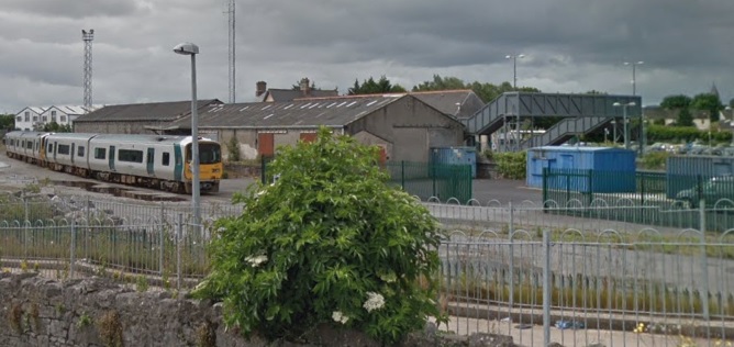
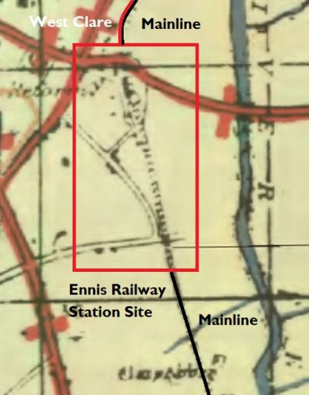
In the past it was also the terminus of the 3ft-gauge West Claire Railway which ran North from the station alongside the mainline. North of Quin Road the land is shown on the adjacent 1917 OS Map as being used by a rail-served sawmill.

South of Quin Road, the grass triangle on the satellite image above provided facilities for the West Clare Railway. These included a carriage-works a turntable and an engine shed. A platform extended under the Quin Road bridge and a water tank could be found on the North side of the abutments of the bridge.

It is interesting to note that the Sawmill was rail-served by both railways with the broad-gauge having a siding crossing the 3ft-gauge lines.

The facilities shown to the South of the station buildings were those for the main-line. [29]

The adjacent map  is the best excerpt that I could find from the GSGS 1-inch map from around 1940. [17]

The map below that is an extract from the Bartholomew quarter-inch map from 1940. Which shown Ennis station and the 3ft-gauge West Clare line leaving the mainline to the North. [18]

The picture immediately below these maps shows the line of the West Clare which ran on the West side of the mainline. The West Clare is long-gone by the time this picture was taken and the mainline track layout has been streamlined

The following monochrome picture looks back through Quin Road Bridge to Ennis Station and shows the two 3ft-gauge lines passing under the bridge.

Two lines of the West Clare Railway originally passed under Quin Road Bridge and served engine shops, a goods shed, loading bays and a transfer bank with a 3-ton crane all in a compound on the North side of the bridge. [16]A diesel railcar about to leave Ennis Station on 25th July 1954, (c) IRRS. The West Clare had its own bridge span under Quin Road. That span has now been blocked off. [16] This general view of Ennis Station was taken in May 1950 by P.B. Whitehouse. The 3ft-gauge Engine Shed can just be seen on the very right of the picture. [30] Loco No. 6C is shunting in front of what is marked on the OS plan as a sawmill at Ennis. Taylor records that building as being a transshipment shed. The year is 1954 or 1955. The broad-gauge siding can be seen crossing the 3ft-gauge to access the shed. Taylor also talks of a loco-repair works being to the right of the transshipment shed, (c) L. Hyland. [31]Loco No. 3C is taking on water in the above image. This is an image from the early 1930s and the loco was less than 10 years old at the time, (c) A.W. Croughton. [31]A ‘Walker’ of Wigan railcar travels north from Ennis Station on the West Clare, alongside is the Irish standard gauge line. [27]This monochrome image shows the two railway lines running parallel across the twin bridges over the River Fergus at Clonroad, around a mile North of Ennis Station, in 1953. The picture is taken looking back towards Ennis. (c) IRRSThis map is another extract from the GSGS 1-inch map from around 1940. It shows the West Clare line leaving the mainline just to the North of the modern R352 Tulla Road which is then pictured in Google Streetview image which follows. The bridge over the Tulla Road is shown in 2017 and clearly shows a modern reinforced concrete deck spanning masonry abutments. [17]Tulla Road Railway Bridge from the West. The West Clare crossed this bridge on the near side of the mainline railway.

Over a distance of about 300 yards north of the Tulla Road the two lines curved gently to the right taking a more northerly path. As they did so they crossed a small stream on a fine stone-arched bridge. One hundred yards further on, at Corrovorrin level crossing, the old road to Ballycoree crossed the two railways. The road is now very much a minor road but was once one of the main roads out of Ennis. [19]

Just beyond this crossing the West Clare Railway diverged from the mainline. Its route is shown approximately by the red line on the satellite image above.The line curved around to travel almost due East before crossing Shaughnessy’s bridge just a stone’s throw from the boundary wall of Our Lady’s Hospital. The curving line through what is now the hosuing estate was known as Tank Curve after the huge hospital water tank.The West Clare continued in a westerly direction crossing the R458 Gort Road. The old road can be seen on the left of the above satellite image joining the alignment of the modern road at the top of the picture. The line continues West towards the River Fergus as shown below.The West Clare crossed the River Fergus on the ‘Lifford Bridge’ as it was called in the Clare Saturday Record report of 20th August 1887, which described an attempt to blow up the bridge that week. Edmund Lenihan comments: “The job was bungled, however, and the bridge still survives, though somewhat the worse for wear. All that remains is the skeleton of girders which once supported the metal deck, and these have not weathered the years well since their laying down in 1886. They are seriously corroded at many points and gave us several heart-stopping moments as we picked our way carefully across. Testing our luck and our balance, we hopped from girder to rotten girder, while under us the Fergus flowed fast and deep. No person in his sane senses would wish to fall in here, but the children of the town often thought otherwise, for on hot summer afternoons the more daredevil among them, bent on mischief, would climb onto the last carriage as the train pulled slowly away from Lifford Halt, ready themselves as it approached this bridge, and then jump off into the river as it crossed.” [19]A few hundred yards further along the old line it crossed Drumcliffe Road on a low girder bridge. The abutments still remain (above). The line then continues to curve round from west to North and crosses a narrow point on Lough Cleggan (on the satellite image below).

We arrive next at a level crossing, the first since Lifford Halt – Erinagh Crossing, in the townland of Reascaun, 3.5 miles from Ennis. The picture above shows the railway formation arriving at the Crossing.

The adjacent satellite image shows that crossing at the bottom of the extract from Google Earth.

The adjoining house no longer looks like a crossing cottage. It has been too much modernised and altered to be recognisable as such. [22]

The picture below shows the bungalow that was once the crossing-keeper’s cottage. North of the extended cottage the line crossed open fields and then, on an embankment, a boggy marsh which is evident at the top of the adjacent image and at the bottom of the satellite image below. North of the marshland the route of the line has been re-landscaped and is very indistinct on the ground and on satellite images. [22]

North of the marshland the West Clare crossed the road running Northeast from Ballygriffey at grade right next to Ballygriffey Castle and on the West side of the small stream which it had crossed on a bridge a couple of hundred yards short of the road crossing.

The monochrome image below shows Ballygriffey Castle and the minor road crossing close by.

As a gated crossing there was a crossing keeper and cottage. Once again the cottage has been so reconstructed that none of its railway features remain.

The crossing, 4.75 miles from Ennis, and we are now entering the 7-mile length to Willbrook that was once under the jurisdiction of Corofin Station. Ballygriffey Castle and railway crossing gates in 1953, (c) IRRS. [23]
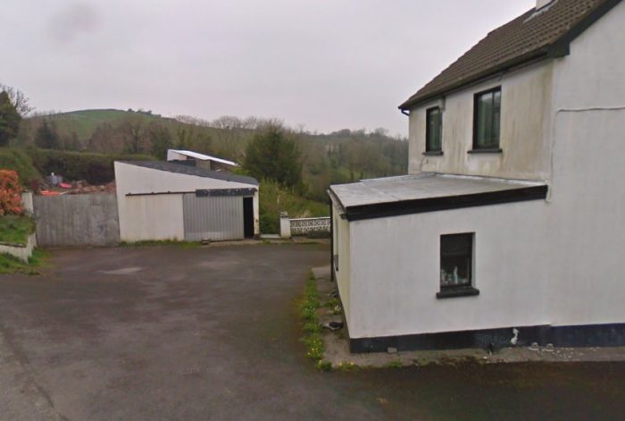
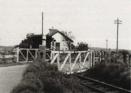
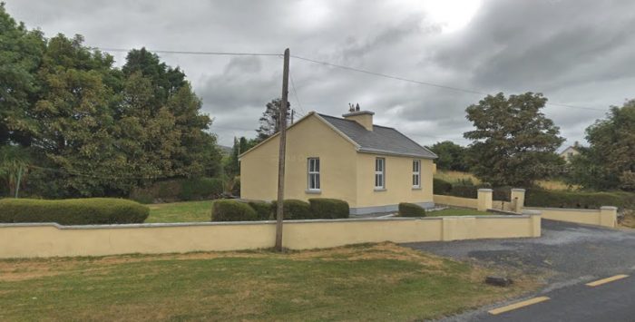
The extended crossing-keepers cottage is seen above from the Southwest in April 2009.

North of the cottage, a ballast siding was established in 1904 and a quarry opened alongside to supply the needs of the railway after the siding at Skagh Point near Kilrush was closed because of a dispute with the Crown over royalties. Edmund Lenihan comments: “One would be hard put now to say where the siding was, since not alone has it vanished, but the line, too. Yet if some of the survivors of the backbreaking slavery undergone here are to be believed, its obliteration is little loss to the world.To be consigned to ‘duty in Ballygriffey’ was akin to penal servitude, it seems, for even the gangers in command were more truculent here than else-where, as if the place exuded some baleful influence of its own.” [23]

The railway gradually turned towards the Northwest as shown on the adjacent satellite image running to the East of the hamlet of Ballygriffey North and then crossing another marshy area on embankment.The railway crossed open limestone grassland on its way towards Ballycullinan Lough. On the way it crossed three roads. The first of these was the site of Ruan Station and Level-Crossing. The third is now the R476 which itself is heading for the next village on the line, Corofin. [24]Ruan Crossing Gates and Crossing-keeper’s cottage in 1953. [25]A Google Earth image of Ruan Station in the early years of the 21st Century.Looking back along the line towards Ennis in April 2009. The stone pilasters in the centre of the image are the pillars which held the crossing gates.Ruan Station Building. The picture is a Google Streetview image and was taken in April 2009.

Ruan station-house is, “resplendently restored and transformed into an elegant dwelling quite unlike the general run of modern country houses. From the boundary wall to the road, where the crossing gates once stood, the line is now a neat garden and lawn, but even more noticeable is the surrounding stonework, for much care has been taken to preserve it, especially the level-crossing piers. It is altogether a credit to its owner. Hard to believe, looking at it now, that this same building was sold by CIE in October 1962 for the princely sum of £15.” [25]

Properly speaking, this station should not have been called Ruan Station, since it is in the townland of Kilkee East, and the village of Ruan is a good 2.5 miles away. However, it would have been highly confusing, even on the West Clare, to have two destinations of the same name. So Ruan Station it had to be, and Kilkee remained the western terminus of the line.

“Ruan Station was first made a halt in 1888, but only after some rather novel persuasive tactics by the parish priest, Fr Garry. It seems that the railway company had no intention of providing even a halt at Ruan, let alone a station, so the priest (who is described as ‘a tall, powerful man and a forceful character’ who got his own way in most things) took to driving his pony and trap onto the line, forcing the train to stop. The company at last got the message; since it looked as though they would have to be constantly stopping anyway, they decided to make it official in 1888. Ten years later, however, it was closed, only to be reopened in 1904 — whether by Fr Garry’s efforts we do not know. That worthy man continued as parish priest in Ruan until 1912, and is buried there.” [25]

In 1921, the halt was closed again, and the platform removed. [25]

Heading on from Ruan, the line continued in a Northwesterly direction and met the modern D476. The crossing was at grade and at a very shallow angle as can be seen on the satellite image below.For a short distance, the road and railway ran parallel to easch other in close proximity. The road then turned North to Corofin and the railway turned gradually to the West and on the way entered Corofin Station. [24]

Corofin Station in June 1961, just after closure earlier inn the year, (c) IRRS. [28]Google Streetview image of Corofin Station buildings in 2009.Corofin Station in 2017. [26]

We complete the first part of our journey along the West Clare Railway at Corofin.

References

  1. P.B. Whitehouse; The West Clare Railway; in The Railway Magazine Volume No. 601, May 1951, p296-298, p320, p345. (Articles from back copies of the magazine can be found online using a subscription service to The Railway Magazine archives.)
  2. http://clareherald.com/2014/09/old-images-of-clare-ennis-railway-station-1950, accessed on 6th April 2019.
  3. https://commons.wikimedia.org/wiki/File:Ennis_Station_-_geograph.org.uk_-_296727.jpg, accessed on 6th April 2019.
  4. http://www.skibbereeneagle.ie/ireland/west-clare-railway, accessed on 6th April 2019.
  5. http://www.westclarerailway.ie/about/history, accessed on 6th April 2019.
  6. http://clareherald.com/2015/07/old-images-of-clare-ennis-railway-station-1962, acessed on 6th April 2019.
  7. https://en.wikipedia.org/wiki/Ennis_railway_station, accessed on 6th April 2019.
  8. Edmund Lenihan; In the Tracks of the West Clare Railway; Mercier Press, Dec. 2008, p16-19.
  9. Ignatius Murphy; The Kilrush-Kilkee Railway and Reclamation of Poulnasherry Bay; in The Other Clare, Volume 6, 1982, p16.
  10. Ibid, p17. But note also the Clare Journal of 26th March 1849, and 2nd April 1849, which berated the gentlemen of Clare for their lack oof interest in ensuring that the proposed branch line from Limerick to Galway should pass through the county, whereas their Gaway counterparts were suitably active in this matter.
  11. In July 1866 a case of traverse in the matter of Kilrush and Kilkee Railway Company came to court. A Mr. Shannon was claiming £600 compensation for land that was to be taken by the railway in Leaheen and Kilnagalliagh. The company was offering £200. See the Clare Journal,12th July 1866.
  12. Munster News; 29th May 1869 and 25th August 1883.
  13. Clare Saturday Record; 6th March 1886, and L. Hyland, Twilight of the West Clare, 1961, p1 (pamphlet distributed on the day the line closed).
  14. H. Fayle; Narrow Gauge Railways of Ireland;  Greenlake Publications Ltd., London, 1946, republished 1970, S.R. Publishers Ltd., London, p78
  15. Edmund Lenihan; In the Tracks of the West Clare Railway; Mercier Press, Dec. 2008, p21-25.
  16. Edmund Lenihan; In the Tracks of the West Clare Railway; Mercier Press, Dec. 2008, p29-32.
  17. https://maps.nls.uk/geo/explore/#zoom=7&lat=53.3993&lon=-7.9500&layers=14&b=1, accessed on 7th April 2019.
  18. https://maps.nls.uk/geo/explore/#zoom=7&lat=53.3993&lon=-7.9500&layers=13&b=1, accessed on 7th April 2019.
  19. Edmund Lenihan; In the Tracks of the West Clare Railway; Mercier Press, Dec. 2008, p40-43.
  20. H. Fayle; Narrow Gauge Railways of Ireland;  Greenlake Publications Ltd., London, 1946, republished 1970, S.R. Publishers Ltd., London, p81.  These cars, No. 395 and 396, were, in fact, found not to be powerful enough to handle the gradients on the West Clare section of the railway. They were as a reult restricted to use on the more level Kilrush to Kilkee service.
  21. Of all the carriage works, only a carpenters’ shop, employing three men, was left by 1941.
  22. Edmund Lenihan; In the Tracks of the West Clare Railway; Mercier Press, Dec. 2008, p51-54.
  23. Edmund Lenihan; In the Tracks of the West Clare Railway; Mercier Press, Dec. 2008, p57-58.
  24. https://maps.nls.uk/geo/explore/#zoom=14&lat=52.9116&lon=-9.0299&layers=14&b=1, accessed on 9th April 2019.
  25. Edmund Lenihan; In the Tracks of the West Clare Railway; Mercier Press, Dec. 2008, p63-65.
  26. https://www.pandacoz.com/day-17—to-galway.html, accessed on 9th April 2019.
  27. http://forum.modelarstwo.info/threads/wagony-motorowe-w-europie.15235/page-6#lg=post-211343&slide=5, accessed on 9th April 2019.
  28. Edmund Lenihan; In the Tracks of the West Clare Railway; Mercier Press, Dec. 2008, p80-85.
  29. Patrick Taylor; The West Clare Railway; Plateway Press, 1994, p37.
  30. Patrick Taylor; The West Clare Railway; Plateway Press, 1994, p35.
  31. Patrick Taylor; The West Clare Railway; Plateway Press, 1994, p36.

The Listowel and Ballybunion Railway

Over Christmas 2018 I was looking through a number of old issues of The Railway Magazine. In the May 1950 edition, I came across a short article about the Listowel and Ballybunion Railway. [1]

The line was over 9 miles long and operated on a system which I believe was not replicated elsewhere in the UK or Ireland. It was a unique form of monorail. I have known of the existence of the railway for sometime and had thought that I would one day get round to writing a little about it.

The Railway Magazine article was written around 25 years after the closure of the line in the 1920s. It says: ” The permanent way in use was described by its inventor M. Lartigue, as being on the monorail system; but, although the weight of the train was taken by the carrying rail supported on trestles, two guiding rails, one fixed on each side, near the feet of the trestles, were used. The trestles were 3ft high, and the line practically followed the natural contour of the country; any slight excrescences were levelled so that the carrying rail was everywhere 3ft above surface level. Stability was obtained by sinking the legs of the trestles to a sufficient depth in the ground, and attaching a crosspiece to each pair of legs. The saving in cost was thus great in respect of preparation of roadbed and ballasting, both of which, as known in standard permanent-way construction, were, so to speak, non-existent. Switching and turning were effected by means of pivoting sections of track.” [1. p337]

“The reason for the adoption of the Lartigue system was cheapness of construction. The sea sand at Ballybunion, a small seaside resort on the Atlantic, in County Kerry, near the mouth of the Shannon, had been found to be particularly rich in phosphates; and Lord Devon, who owned considerable estates in the West of Ireland, was anxious that it should be available for fertilising purposes over a wider area. When it was explained to him that a railway for the purpose could be constructed very economically on the Lartigue system, he warmly in supported the scheme; and it was decided to build such a line to Listowel, a small market-town between 9 and 10 miles inland, served by the Limerick-Tralee line of the (then) Waterford, Limerick & Western Railway.”

“The late Mr G.A.Sekon, writing in The Railway Magazine in November 1924, stated that on 16th April 1886, Parliamentary sanction was obtained for the construction of the Listowel & Ballybunion Railway on the Lartigue monorail system. ‘The route mileage,’ he continued, ‘was 9.25, but as the peculiar conditions requisite for the working of the railway required considerable auxiliary lines, the track length was 10.25 miles.’ The capital was fixed at £22,000, with £11,000 borrowing powers, from which it will be observed that the total estimated for the purchase of land, construction of the railway, and provision of rolling stock was only £3,300 a mile. It is of interest to note that, following the passing of the Act, a full-size model railway on the Lartigue system was built on the site of Tothill Fields Prison, Westminster, in July 1886. On this line were gradients of 1 in 10 and curves of 49ft. radius.” [1. p337]

These drawings can be found in the Gallery on the website of the present day heritage attraction. [5]

Construction began in August 1887 and the line opened to traffic on 1st March 1888. There was an intermediate station at Liselton and two places that the train would stop when signalled to do so. Later, a second intermediate station was added at Francis Road. Speed seldom reach 20mph and over 40 minutes were timetabled for the journey. In winter 2 services were provided in each direction. This increased to 5 regular services with son additional ones added as required.

These drawings can be found in the Gallery on the website of the present day heritage attraction. [5]

The railway at was not a financial success. Its highest receipts were taken in 1913 – £740. Usually the railway ran close to break even. In 1897, the company passed into the hands of receivers and remained so until its closure in October 1924. At that time the permanent-way and rolling stock were dismantled and sold for scrap.

The rolling stock was necessarily of twin design. An unusual feature of operation was the necessity for the guard to ‘balance the train’ by ensuring the loading of an approximately equal number of passengers or weight of goods on each side. There were three locomotives, and at one time there had been a fourth; the last-mentioned had been built abroad and was smaller, and was possibly used at Tothill Fields. The other three were built by Hunslet Engine Co. Ltd., Leeds. Each had two parallel boilers, and was suspended on three coupled axles, with wheels 24 in. in diameter placed between the twin boilers. The tender also could be made to exert driving power; it was carried on two coupled wheels, 24 in. in diameter, with a wheel base of 4ft 3in., and was driven by two cylinders, 5in. diameter by 7in. stroke.” [1, p337-338]

Having read the article in The Railway Magazine it seemed that a little research online would be appropriate. Some further information about the railway and its method of operation came to light. It also became apparent that a modern facsimile has been built which has become a visitor attraction in Co. Kerry.

The Lartigue System

The Lartigue Monorail system was developed by the French engineer Charles Lartigue (1834–1907). He developed a horse drawn monorail system invented by Henry Robinson Palmer [4] in 1821. [2] The most well-known example of the system was that constructed between Ballybunion and Listowel, but another line, 17 km (11 miles) long, was built in 1895 between Feurs and Panissières, in the French departmente of Loire. The adjacent image shows a locoi motive and carriage from that line.

Lartigue saw camels in Algeria carrying heavy loads balanced in panniers on their backs. This inspired him to design a new type of railway. Instead of the conventional two parallel rails on the ground, it had a single rail sitting above the sand and held at waist height on A-shaped trestles. The carriages sat astride the trestles like panniers.

By 1881 Lartigue had built a 90 km (56 mi) ‘monorail’ to transport esparto grass across the Algerian desert, with mules pulling trains of panniers that straddled the elevated rail.

However the Lartigue system as built was not truly a monorail, since it was necessary to add two further rails, one on each side, lower down the A frames. These did not carry any weight, but unpowered stabilising wheels fitted to all the engines and wagons contacted these extra rails to prevent the vehicles from overbalancing. [3]

The Wikipedia article about the line notes:

“Locomotives were specially built with two boilers to balance on the track, and consequently two fireboxes, one of which had to be stoked by the driver.” [3]

“They were also fitted with powered tenders for auxiliary use on hills. The tender wheels were driven by two cylinders via spur gears. Two small chimneys were fitted to each tender to discharge the exhaust steam from these cylinders. A smaller engine, nicknamed the “coffee pot”, was used in the construction of the railway, having been used previously on a demonstration line at Tothill Fields in London. It can be seen on an early photo of 1888.” [3]

Loads had to be evenly balanced. If a farmer wanted to send a cow to market, he would have to send two calves to balance it, which would travel back on opposite sides of the same freight wagon, thereby balancing each other. Another problem with using the Lartigue system in populated areas was that, due to the track’s design, it was not possible to build level crossings. In order for a road to cross the track, a kind of double-sided drawbridge had to be constructed, which required an attendant to operate it. [3]


A picture of a level crossing taken from The Railway Magazine, May 1950. [1]


A similar road crossing in the down position. [5]

“Where farmers’ tracks crossed the line there were level crossings based on the principle of a turntable. These were locked and the farmer in question provided with a key. Once unlocked, the track could be swivelled to one side to allow the crossing to be used. Both the swivelling and drawbridge type crossings were automatically linked to signals, which stopped any approaching trains; road traffic was always given priority under this system.” [3]


A picture of a farm track crossing taken from The Railway Magazine, May 1950. [1]

Passengers could not pass from one side of a carriage to another while in motion. A kind of footbridge was built into one end of some of the passenger coaches, while at least one such bridge was carried on a separate wagon. This allowed passengers to cross from one side of the line to the other when the train stopped at a station.

“Conventional railway points could not be used, so a similar function was fulfilled by a large number of curved movable pieces of track which, when rotated one way, would connect the main and one direction; when turned end-for-end, the curve went in the opposite direction, and so connected the main and a different track. These could not be called turntables since they could only be moved when there was no rolling stock on them.” [3]

The line closed in 1924 after the track was damaged during the Irish Civil War, and everything was scrapped, except a short section of the track. [3]

I have found videos on YouTube about the Listowel to Ballybunion line:

It is fascinating to note that a stretch of this line has been reconstructed to give modern holiday-makers a taste of what the line was like in the early 20th century. Nowadays, a visit includes a short demonstration journey on a full-scale diesel-powered replica of the original monorail. During the journey people experience the unique features of the monorail and are able to observe its ingenious switching system. Before or after a journey, it is possible to visit the Lartigue Museum to watch film of the original Lartigue and see models, displays and memorabilia of the Lartigue and main-line railways. [5]

References

1. The Listowel and Ballybunnion Railway; The Railway Magazine, Volume 96, No. 589, May 1950, p337-338.

2. “The Lartigue Railway”. Australian Town and Country Journal. NSW. 19 March 1887. p. 32. Retrieved 23 February 2013 – via National Library of Australia …. reviewed on 31st December 2018. The text of that article was as follows:

The Lartigue Railway.
The Lartigue railway system is that of a series of cars drawn by horse-power or a specially constructed locomotive, running on a single rail elevated a few feet from the ground. The system has been in use since 1883 in several parts of Europe and Africa; and a model line has recently been shown in action near Victoria Street, Westminster, London. The main features of the system, which is applicable to military, agricultural, or manufacturing lines, are as follows:
The line, which is exceedingly portable, is composed of one rail, of the shape of a flat bar, extremely rigid when subjected to vertical pressure, but easily bent horizontally. This rail is supported above the ground by A-shaped trestles, or frames, made of angle, or some very stiff section of iron. The upper extremity of these trestles is bolted to the rail; and the lower extremity rests on the ground, being supported by a bed-plate or sleeper, to which the frame is firmly secured. The sleepers may be of different sizes, and shapes, and may farther be secured in their places when required by long pegs driven into the ground through holes drilled near the extremity of the sleepers; thus preventing the line from shifting. If a river has to be crossed, some light piers can be made, or two wire cables may be stretched across to receive the trestles of the line; while if a ravine, has to be traversed the line can either be carried directly over the gap, or taken down the gorge by means of a zig-zag length, which can be connected by curves of as small a radius as 10ft. Moreover, it is possible to use gradients as steep as 1 in 17. On passenger lines guards, to prevent the swinging of the cars, and points, sidings, signal, &c., have been introduced; and everything has been constructed with a special eye to simplicity. The cars are fitted with two grooved wheels; which run on the rails; but are fashioned according to the purpose for which they are intended. The passenger carriages, as well as the locomotives, are fitted with horizontal grooved wheels, which run on side guide lines, attached to the trestles by the side of the main line, thus imparting steadiness. As our sketches (above) show, it has been tried in Russia, both for the transport of troops and of military invalids; in the Pyrenees it is used for carrying ore, while its facilities, for passenger traffic were tested at the short line at Westminster. It has been shown at various European exhibitions, and is in use in Algeria and Tunis for carrying esparto grass. Indeed, it was while seeking to solve the problem of carrying the grass from the plains to the mainlines of communication that the idea of the single-line railway first occurred to the inventor, M. Lartigue; the appearance of a caravan of camels in the distance laden with bags on each side of their humps furnishing the starting point. The advantages claimed for the line are its extreme simplicity and portableness. Unevenness of the ground can be balanced by different lengths of trestles, while the motive power can be, either electricity, horse traction, or steam. The inventors say that during a trial in Russia 6ft 6in were laid down in six minutes by six men, so that a mile could be completed by thirty men in eight hours. In this instance the line was raised 3ft 3in above the ground.

3. https://en.m.wikipedia.org/wiki/Lartigue_Monorail, accessed on 31st December 2018.
4. https://en.m.wikipedia.org/wiki/Henry_Robinson_Palmer, accessed on 31st December 2018.
5. http://www.lartiguemonorail.com, accessed on 31st December 2018.