
The Tramroad in Gloucester. …
In the last article in this series we had reached a point of the journey from Cheltenham where the tramroad passed along the North side of what was later to be Barnwood LMR Locomotive Depot.
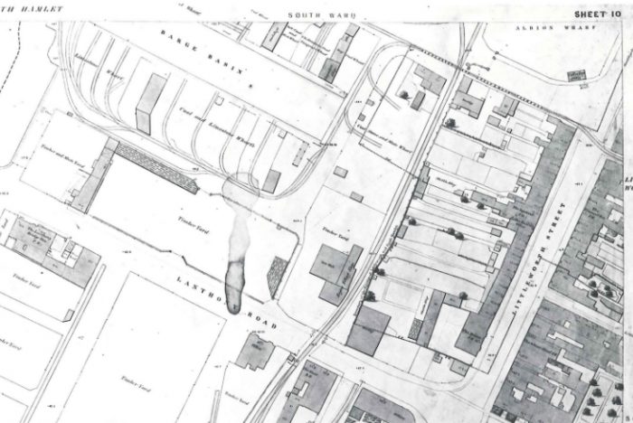
The first map below is the 6″ 1882 OS Map and shows the approximate alignment of the tramroad which had already been lifted by that date. The 1886 25″ OS Map is very similar to the 1182 Map but things changed somewhat over the next decade. The second map below is the 25″ OS Map from the turn of the 20th century. Tramway cottage has been removed by this time. The MPD roundhouse was at the right hand end of that OS Map extract. The third OS Map extract below comes from the 1930s when the sidings to the Southwest of the Roundhouse had been increased in number. The old tramroad embankment can be made out running behind the two jinties stabled at Barnwoood MPD (c) Roger Smith, used with permission.
The locomotive depot is now long-gone and the land turned over to industrial use. The Google Streetview image below the OS Maps is taken at the end of Myers Road. It is difficult to fix the exact location of the tramroad here. It clearly ran through the site in the picture between the two access roads that are visible. The line probably ran near to the right-hand access road. 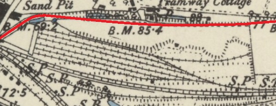


 The view East from the end of Myers Road towards what was the location of Barnwood MPD Roundhouse (Google Streetview).
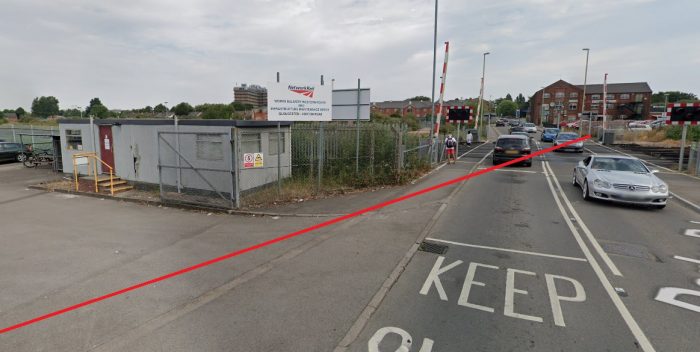
As the OS Map extract above suggests, the tramroad curved round to the Southwest. To cross Horton Road and the standard-gauge lines on the level. The level-crossing on Horton Road was known as Tramway Junction, now Horton Road Crossing. The next image is a Google Streetview image which looks Northeast from the Horton Road Crossing and which as a result looks along the line of the old Tramroad as it heads to the Northeast. The second image below is again a Google Streetview image taken from a point 20 metres or so to the south of the first image and showing the route of the tramway crossing Horton Road/Derby Road.
 After crossing what was a small area of open ground and which now carries Metz Way (A 4302) the tramroad joined Millbrook Street. The two following images show this. The first looks to the Southwest and shows the route meeting Millbrook Street, the second looks North East and shows the alleyway which remains long after the tramroad has gone! Both are, again, Google Streetview images.
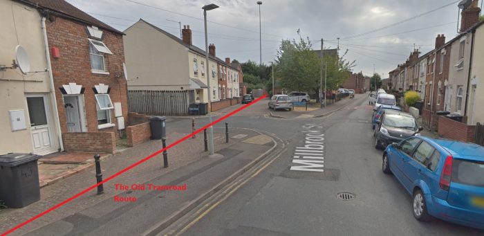 Contact with Millbrook Street is only fleeting. The old tramroad headed away to the West after only a short distance. The footpath shown in the centre of the next Google Streetview image follows its ancient route!
 The route of the old tramroad through Gloucester can be found in D.E. Bick’s book, [2: p16] and B. Baxter’s article. [3: p118], rather than reproduce either of these images here, the route is followed in detail on OS Map extracts. The first of these shows the length from Tramway Crossing/Junction on Horton/Derby Road in the East to very close to the old Eastgate Station (LMR). One its way, as we have already noted the line touched Millbrook Street and then ran across the backs of the houses on Napier Street towards Barton Iron Foundry. To the North of the old route today is Widden Primary School, and the ASDA superstore.
 Causton’s 1843 Map of Gloucester shows the Tramroad at this location in open fields. The tramroad was, in 1843, in the heyday of its working life and had not been encroached upon by development. Its route is highlighted in yellow on this extract. [6]

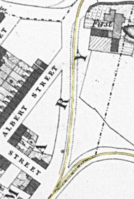
In the extract from Causton’s map above, the tramroad is seen entering from the East and then turning sharply towards the Southwest as it approached what in 1843 was the outer limits of the built-up area of Gloucester. The street entering from the West is Cambridge Street. Marked on the extract is a passing loop. just to the West of the sharp curve in the alignment of the tramroad and perhaps of greater significance a branch heading way to the North along what was to become first Barton Lane and then Station Road.
At this time, there was no Eastgate Station. Gloucester’s only railway station was located on the site of the complex that in the 21st Century continues to serve as Gloucester’s Railway Station. The railway station, in 1843, was to the North of the Tramroad.
 The tramroad predated the larger-gauge network in Gloucester and a link must have been provided to connect the Railway Station with the Tramroad when the larger scale lines were opened.
Later maps suggest that the tramroad link to the station was replaced by a larger-gauge (broad-gauge) siding. [4: 1852 Board of Health Map]
To the South, the tramroad ran down to a level-crossing at Barton Street and onto Park Road (or Park End Road). Just South of Barton Street there was another passing loop provided. This length of the tramroad had to be maintained even after the construction of the larger scale railways which used its route over this very short section.
Baxter notes that this section of the tramroad, “was used by the two railways which jointly bought the tramroad shares, but, as the tramroad continued to work independently for more than twenty years after its acquisition, the tramroad track must obviously have been maintained on a course parallel with the new railway.” [3: p119] Sadly, the large scale .jpg image of Causton’s 1843 Map, that I have access to, does not cover the full extent of the tramroad. The tramroad leaves that copy of the map just to the Southwest of the passing loop which we have already noted and which appears at the bottom of the extract above. [6] Other copies of Causton’s map available on line are not so well defined and are blurry. They do, however, show the tramroad looping through open fields as it turns Westward.
Just off the bottom of the copy of the map that I have, the tramroad turned to the right and took a Westerly course along what became Park Road. It ran on the Northside of Park Road. This is shown on the alignment included by me on the OS Map below after significant property development in the city. OS Map from before the construction of Eastgate Station. The map comes from around the 1880s which means that the tramroad was abandoned by the time it was drawn.
 The Tramroad turns through 90° to head West. This plan is part of a series from 1852. [13]
The tramroad re-appears on my copy of Causton’s map as it travels along the length of Park Road, just to the East of Parker’s Row (later Wellington Street). It is helpful that this length appears on Causton’s map as it allows us to identify a Gloucester and Cheltenham Tramroad depot at the junction of Parker’s Row (Brunswick Road) and Park Road. These buildings stand at the corner of Brunswick Road (one time Parker’s Row) and Park Road on the site of what was once the tramroad depot (Google Streetview).
 What remains of the Depot in the early 21st century (Google Streetview).
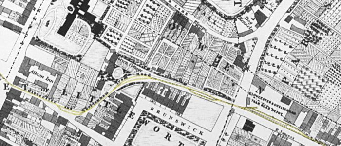 The Gloucester and Cheltenham Tram Road is clearly annotated on Causton’s Map. The route is highlighted in yellow again. [5]
 OS Map extract from 1880s [5]
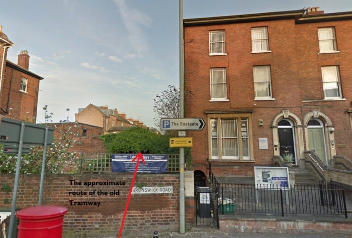 Looking ahead to the West along the line of the old Tramway (Google Streetview)
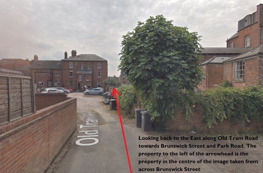 A view East along Old Tram Road (Google Streetview).
 Looking West on Old Tram Road (Google Streetview).
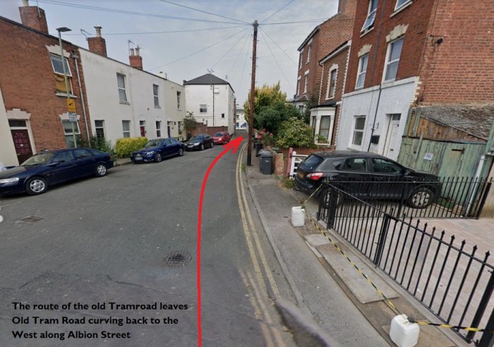 Looking West along Albion Street (Google Streetview).
 The route of the Old Tramroad down Albion Street towards Southgate (Google Streetview).
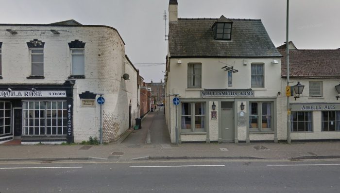 Looking back to the East along Albion Street, the route of the old Tramway. The building to the right of the old Tramroad route is the Whitesmiths Arms, the lower portion of the building, on the right-hand edge of the photograph was apparently the only building south of the city walls that was not destroyed during the siege of Gloucester in 1643 during the English Civil War (Google Streetview).
The next sequence of maps are also extracts from Causton’s Map They show the full length of the tramroad alongside the docks with the route from Cheltenham appearing as two lines entering from the right in the bottom map extract of the sequence. The tramroads have again been lightly highlighted in yellow.

 Gloucester Docks Tramroads before the coming of the railways as shown on Causton’s Map of Gloucester from 1843. The two tramroads shown leaving the bottom right of the map extract immediately above become one tramroad within no more than a few yards and that single tramroad crossed Lower Southgate Street and headed off along Albion Street. [5] In 1824, the Barge Arm, referred to on the above maps as the Barge Dock, was opened and was served by a series of 18 sidings from the tramroad. [6]
The Barge Arm was constructed in 1824-25 permitting smaller vessels to load and unload without occupying space in the main canal basin. Hugh Comway-Jones says that ”the surrounding land was divided into eighteen yards on each side, each yard having a frontage of only twenty feet, although some tenants rented more than one yard. Each pair of yards was served by a siding of the Gloucester & Cheltenham Tramroad. A surviving inventory of 1834 shows that one yard was surrounded by seven foot high fencing, with a pair of gates which opened on wheels. In the yard was a manually operated cast-iron crane capable of pitting seven tons, a tramroad wagon and several barrows used for transferring cargoes between the boats and the tramroad.” [8: p31]
Conway-Jones goes on to describe the various different yards around the Barge Arm and to note that the loss of the tramroad in 1861 was quickly rectified by the provision of sidings by the Midland Railway and by an adjustment of levels of the quay by the dock company. [8: p31]

Tramroad Blocks excavated near the Barge Arm in 1983. Cast Iron plates recover from another location have been placed on the blocks to show the Tramroad construction. [11]
There is also a map of 1829 which shows the tramroad sidings serving the Barge Arm and with similar sidings on the East side of the main Canal Basin. That map was drawn by Sutherland. [10: p31] The south side of the Barge Arm is also shown on the 1852 series of Health plans as being served by the tramroad. [13]
The 1852 plan showing the tramroad serving the south side of the Barge Arm despite the fact that by this time the north side was served by the Midland Railway. [13]
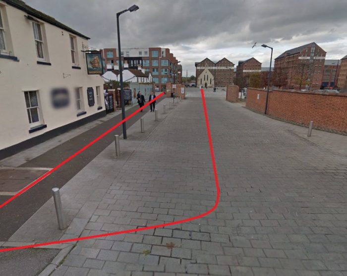 Looking West into the Docks complex at Gloucester with the approximate Tramroad alignments shown in red (Google Streetview).
 Reconstructed Trams placed on typical plateway rails on one of the lines of the old Tramroad (Google Streetview).
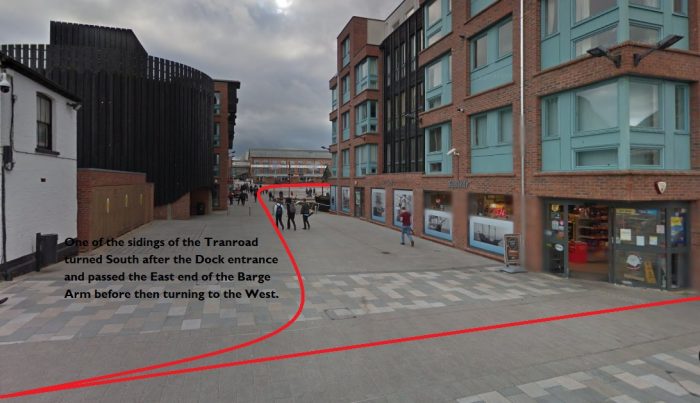 A siding passed down to the East of the Barge Arm (Google Streetview).
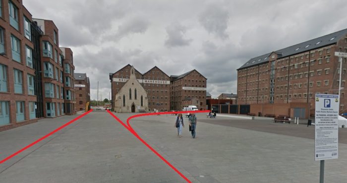 Approximate Tramroad alignments further into the docks (Google Streetview).
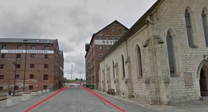 At this location, two of the tramroad arms are remembered with rails let into the modern paving (Google Streetview).
 The old Tramroad route North through the site of the docks (Google Streetview).
 The old Tramway route between the River Severn and the County Gaol (Google Streetview).
I have not provided extracts from the later 1880s OS Map for the area around the docks, as by that time the docks were served primarily by larger-gauge edge-railways rather than the old plateways and those railways dominate the old maps from that period. There is an excellent reproduction of the 1902 OS Map in Hugh Conway-Jones, ”Gloucester Docks: An Historical Guide.” [8: p30] A similar map can be found on the website of British History Online. [12] And there are an increasing number of online resources available for those who are interested. [9]
Interestingly Bick records the fact that the plateway north of the dock entrance was abandoned in the late 1840s or thereabouts. [2: p27] This is supported by the 1852 series of Health Maps which show the north side of the Barge Arm being served by the Midland Railway. [13]
We have now followed the full length of the Old Tramroad. There are a few other bits and pieces that it is worth us considering before we complete this series of 4 articles about the line.
Tramroad Traffic and Operations
There is short document produced by the Gloucestershire Society for Industrial Archaeology about the Tramroad. [6]. In this document a short paragraph provides details of the operation of the tramroad: “At its peak operating period, the tramroad must have been very busy with up to 60 journeys each day carrying over 35,000 tons of general materials and 20,000 tons of stone from the Leckhampton quarries in a single year. Despite competition from the railways and the Coombe Hill Canal, coal from the Forest of Dean was the main material transported along the tramroad, being preferred to Midlands coal and cheaper to purchase. Many different commodities were carried, from stone water pipes from the Guiting Power Stone Pipe Company between 1812-1815, to iron from Horsley in the West Midlands for the new Cheltenham gas lighting project in 1819.” [6]
Other sources such as D.E. Bick note that a tram trains usually consited on 2 trams. Thjis was the usual maximum which could be managed by one horse and the limiting factor was the gradient on the Cheltenham side of Staverton Bridge. I find it really interesting that the tramroad followed a prctice which eventually became prevalent on standard gauge lines of augmenting the power of a locomotive with another on steep sections of line. Stables were provided at Staverton Bbridge for horse which provided support for the tram horses climbing the 1:100 gradient near Arle Court. Could we use a term which became familiar with railways? Could we call this an early example of the principle of ‘banking’? [cf. 2: p36]
Maintenance of the Tramroad
Plateways were maintenance intensive. They required the short cast-iron plates to be leveled regularly, they were particularly intolerant of over-loaded trams. The GSIA document says: “The ‘L’ shaped design of rails needed to be kept clean to prevent derailing of wagons. Replacement of broken cast iron rails was frequently necessary; this may have been aggravated by the desire to carry loads in excess of the weight capacity of the rails. It was reported that poor and unstable ground also contributed to the difficulties of keeping the permanent way open.” [6] It seems that the income derived from the carriage of materials and the tolls levied was never significantly more than the cost of maintenance of the line. [2: p38]
Theft of plates was apparently a common occurrence. Bick quotes one example of a theft of 58 of the plates by one individual. [2: p38]
The Demise of the Tramroad
There were a number of factors which influenced the timing of the final closure of the tramroad. These included:
- The rapid decrease in profits after about 1841. Bick quotes figures which show that a profit of £2,100 in 1841 decreased to about £1,000 in 1850 and to less than £100 by the end of the 1850s. [2: p40]
- The tramroad was, at one time, the most convenient method of transporting Forest of Dean Coal to the Gasworks at Cheltenham. With the opening of the Midland Railways lines in the area it became possible for that traffic to travel entirely by rail and the tramroad could not compete. [2: p40] Talking about this, Wikipedia says: “The South Wales Railway opened in July 1854 and the tramroad suffered a serious blow, as the Forest of Dean minerals could now come much more expeditiously by rail throughout. Its main business was now the conveyance of Leckhampton stone to Cheltenham, its advantage being that it could unload at any point along its line as compared with the Midland Railway which was obliged to do so at a goods depot.” [7]
- One section of the line was overshadowed by the newer edge-railways. … A decision was taken to push a standard-gauge line through Gloucester, close to the alignment of the tramroad where it crossed Barton Street in Gloucester and ran down Park Road. The tramroad and the railway co-existed for a time, although the standard-gauge line cut the tramroad access to the Great Western Railway Station. This removed what had been an important link from the Railway Station to the docks using the tramroad.
- Conway-Jones notes that traffic was, “seriously affected by the arrival of the railway [at the docks] and by the loss of the northern end of the tramroad which was cut across by the excavation for the new dock.” [10: p55] He also notes that coal traffic decreased significantly “in the face of competition from the railways, and complaints about the bad state of the rails running unguarded through the streets.” [10: p71]
- Baxter points out that the Birmingham & Gloucester Railway Act of 22nd April 1836 “empowered that company and the Cheltenham & Great Western Union Railway to buy the tramroad shares, and each paid £17,500 for a moiety in the early days of 1837. Very little of the early route was adopted for the new railways.” [3: p117-118] The purchase of these shares gave their successor companies a major say in the future of the tramroad. When some local interests sought to keep the Tramroad in use after powers to close it had been sought and won, these major shareholders stepped in to ensure closure and the sale of the company’s assets. In particular, most of the plateway was lifted and sold, a large proportion ended up in the Forest of Dean. [14]
- One short section of the Leckhampton Branch remained open for the carriage of stone until late in the 1890s. [14]
The Tramroad served for about 50 years and was a major contributor to the local economy. It’s value to Cheltenham was significant. It brought Forest of Dean coal to the Gas Works which supplied the town’s gas and allowed for significant exports of limestone for building and road construction. It remained popular with a number merchants right up to its demise, as it offered a greater flexibility for deliveries than the newer railways. Ultimately, it seems that it’s end arrived because other forms of transport became cheaper and were faster, even if less flexible.
References
- https://osmaps.ordnancesurvey.co.uk/51.86236,-2.22658,18, accessed on 6th May 2020.
- D.E. Bick; ‘The Gloucester & Cheltenham Railway and the Leckhampton Quarry Tramroads’; The Oakwood Press, 1968.
- B. Baxter; The Route of the Gloucester & Cheltenham Railway; The Railway Magazine, February 1953: p117-121 & p133.
- https://maps.bristol.gov.uk/kyp/?edition=glos, accessed on 6th May 2020.
- https://upload.wikimedia.org/wikipedia/commons/e/e6/Causton’s_1843_map_of_Gloucester.jpg, accessed on 4th May 2020.
- https://www.gsia.org.uk/gct/gsia-tramroad-history.pdf, accessed on 30th April 2020.
- https://en.wikipedia.org/wiki/Gloucester_and_Cheltenham_Tramroad, accessed on 30th April 2020.
- Hugh Comwy-Jones; Gloucester Docks: An Historical Guide; Black Dwarf Lightnoor Publications Ltd., Lydney, Gloucestershire, 2009.
- On-line Maps, over-and-above those developed by Google and Microsoft, include those available from the National Library of Scotland, https://maps.nls.uk; the Ordnance Survey, https://osmaps.ordnancesurvey.co.uk; Know Your Place, https://maps.bristol.gov.uk/kyp/?edition=glos.
- Hugh Conway-Jones; Gloucester Docks: An Illustrated History; in the County Library Series, Allan Sutton, Gloucester and Gloucestershire County Libraries, 1984.
- https://www.gloucesterdocks.me.uk/studies/tramroad.htm, accessed on 25th April 2020.
- https://www.british-history.ac.uk/vch/glos/vol4/pp251-258, accessed on 8th May 2020.
- http://www.glosarch.org.uk/glosmapsprospectspdffiles.html, accessed on 8th May 2020.
- Bick provides some details of the machinations which went on around closure [2: p27-29] Once the abandonment Act was obtained in 1859, initially little was done by those empowered to take action. It wasn’t until March 1861 that significant action was taken by the GWR to enforce closure and sale. One small remnant of the line was, as we have noted in a previous article, trained almost to the arrival of the 20th century. [2: p29 & 51]

Roger,
I am again very impressed by the amount of research you have put into the final part of this series of articles.
However, as I am very familiar with the area covered by this part, there are a number of minor changes that you might like to consider.
They are detailed in the attached document. If this doesnât come through then please contact me on roger.smith2019@hotmail.com.
Regards
Roger Smith
Thank you Roger
I will send you an email as I cannot find the file you mention.
Sincerely
Roger
Pingback: Gloucester Docks and Railways – Part 1 | Roger Farnworth
Absolutely fascinating, I have often wondered where the tramlines were routed. It intrigues me how the tramlines crossed the railway lines at Horton Road, it must have been very complicated with lines and overhead power cables.
Well done on your research, it is much appreciated.
Bob Lusty. (EX GWR,Horton Road Sheds).
I am very impressed with the degree of additional research to compliment material already in the public domain. Questions I had on its route/geography and why the endurance of the system prevailed so far into the era of railways, are addressed in your research. Will this be your final publication or is there a printed paper We can purchase? I would be pleased to support the research where I can.
Hi Phil, thank you for your kind comments. I really enjoyed producing this material. I had not thought to publish. I guess that quite a few of the images used would need to be higher quality than they are in these articles.