

For Iranians, life changed dramatically in 1979.
It is easy, from a Western perspective, to assume that Iran is a country that has chosen to avoid progress. So, I have to admit to being surprised by the current state of the railways in Iran. The network has been developing at a significant pace. Since 1979 there have been a significant number of major construction projects and there have been some significant changes in motive power.
There are holiday companies [1][2][3] advertising railway trips to Iran. Given what is reported about the instability of the country and its sponsorship of, what to Western eyes are, terrorist groups, these holidays do not feel very attractive. Yet the picture on the ground in Iran is seemingly one of relatively energetic technological development. “Since the first railway project was implemented [after] the revolution, 12 railway projects, that is 4676 km of the total 10171 km of the total network have been constructed. That is about 46% of the total rail routes in the country.” [21]
I hope that this article will provide a taster of what things are like on the railways in Iran today.
Before looking at the situation in detail, here is a video which focusses on the Trans-Iranian Railway in recent times. It was shared by D6700 a member of RailUKForums as part of a thread about Iranian Railways. [4] It is produced by a German team but the dialogue is in English. It gives a good impression of technological developments and notes a reluctance from many of the people encountered to talk with the Western film-crew.
The Trans-Iranian Railway. [4]
The notes that follow are inevitably far from comprehensive and rely heavily on sources on the internet (which are all referenced). A railway map of the network in Iran in the 21st century is provided by the national rail service, Islamic Republic of Iran Railways. The schematic plan they provide is shown immediately below. Not all routes are however shown on the map.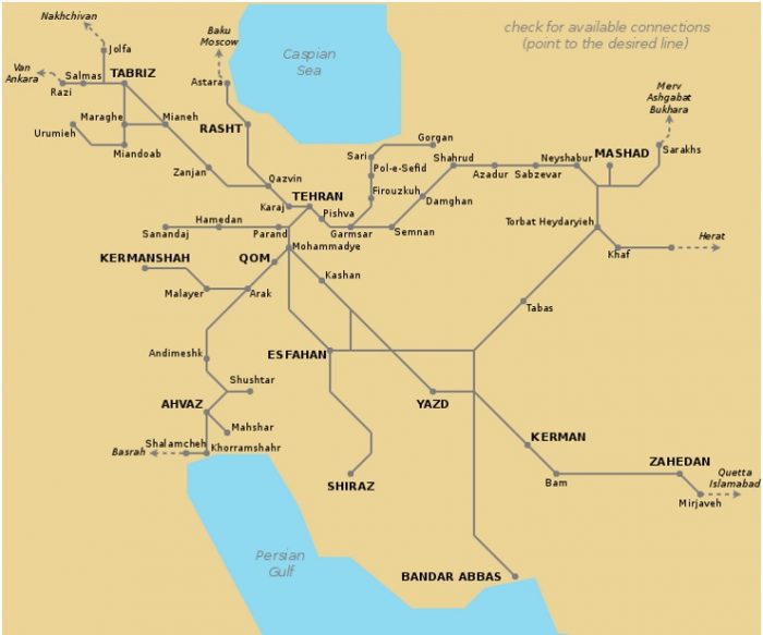 The Iran Railway Network in the 21st century. [6]
Wikipedia [5] notes the long-distance schemes which were undertaken by the Islamic Republic of Iran Railways in the 21st century, these include:
Bafq — Kashmar 800km 1992—2001 (but see the comments below)
Kerman — Bam 225km 1999—2002
Bam — Zahedan 546km 2000—2009
Isfahan — Shiraz 506km 2001—2009
Khorramshahr — Shalamcheh 16km 2009—2012
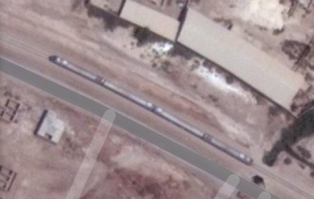
Gorgan — Incheh Borun 80km 2012—2013 [22]
Tehran — Hamedan 268km 2001—2017 [23]
Arak — Kermanshah 267km 2001—2018 [24]
In addition to long-distance services, Iran has also developed commuter service for the major cities and a series of light rail/tramway schemes too.
For example, Tehran Metro carries more than 3 million passengers a day. [7] In 2014, 815 million trips were made on Tehran Metro. As of 2019, the total system was 229 kilometres (142 miles) long, [8] 186 kilometres (116 miles) of which is metro-grade rail. It is planned to have a length of 430 kilometres (270 miles) with 9 lines once all construction is complete by 2025. [9][10]
Commuter Services are currently available in Tehran, Tabriz, Kuzestan, Lorestan, Mashhad and Mazandaran-Golestan. [5]
Commuter and Metro Services are not covered in detail in this article and will have to await a further post as time permits. ……..
Major Schemes
Wikipedia provides the list of schemes [5] above which shows construction, commencing in 1992, of a line from Bafq to Kashmar. Farrail, however, indicates that the line from Bafq to Kashmar and on to Mashhad was not started until 2001, this is verifiable from other sources as well. [11] [12]
1. Bafq to Kashmar and Mashhad – Despite its relatively small size, [13] Bafq has become a major junction on the Iranian rail network. Kashmar is in the Northeast of the country. It is in Razavi Khorasan Province and is located near the River Sish Taraz in the western part of the province, and 217 kilometres (135 miles) south of the province’s capital Mashhad. In the 2006 census, its population was 81,527, in 21,947 families. [14][15] The city is the fourth most important pilgrimage city in Iran. [16] It is a major producer of raisins and has about 40 types of grapes. It is also internationally recognized for exporting saffron, and handmade Persian rugs. [14] It appears to be some distance from the railway. The town of Mehneh, approximately 50km Southeast of Kashmar, is close to the railway but has no railway station. This is also true of Shadmehr, which is 55km due East of Kashmar. Mashhad is the second-most-populous city in Iran and the capital of Khorasan-e Razavi Province. It had a population of 3,372,660 (in the 2016 census), which includes the areas of Mashhad Taman and Torqabeh.[27] It was a major oasis along the ancient Silk Road connecting with Merv to the East.
Trains to Mashhad from Bafq have about 800km to travel to their destination.
As we have already noted and as shown below, the Railway Station at Bafq is on the South side of the town. Bafq Railway Station is on the South side of the town of Bafq. It shown at the bottom of this map extract [17]
East of Bafq Station a triangular junction has the line to Kerman and Bandar Abbas heading away to the South and the line to Kashmar setting off the Northeast. A short distance beyond the town limits this line also divides. The more northerly of the lines serves the Choghart Iron Ore Mine.
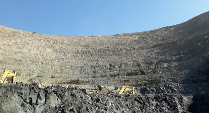 Choghort Iron Ore Mine in February 2019 (c) Reza 39 (Google Maps). [18]
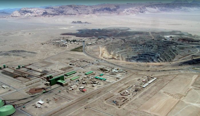 Choghort Iron Ore Mine in January 2020 (c) S.I.G Group (Google Maps). [19]
The main line then also curves round to the North by-passing the industrial complex which surrounds Cloghort MIne and continues on towards Kashmar. It curves past another open-cast mining site and climbs into the hills by means of a series of loops. Mining sites and sidings are a regular occurrence on the route through the hills.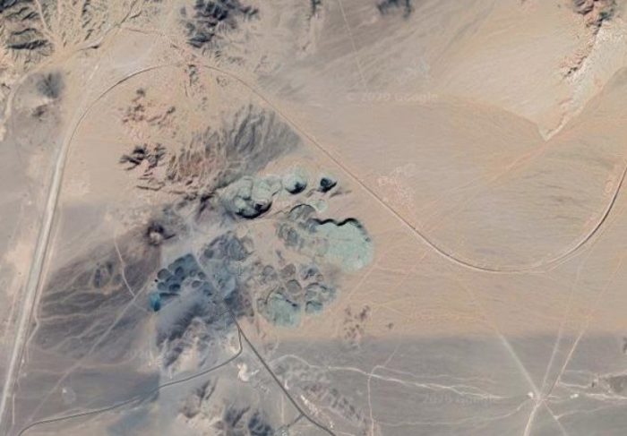
This satellite image shows the trailing connection with the branch-line which serves Chadormalu Iron Ore Processing Plant (at the bottom of the picture) and the loop which allows trains from the branch to head towards Bafq (Google Earth).
En-route through the hills a trailing junction is made with a line that serves Chadormalu Iron Ore Processing Plant and extends on some distance to Meybod. (See Part 5 of this series. [20])
Leaving Yazd Province the line enters South Khorasan Province and continues predominantly in a Northeasterly direction across open wilderness and gradually getting closer to Route 68. A long tunnel takes the line very close to the road and the two transport modes run alongside each other to Dashteqarrān and Tabas.
Tabas is the first station on the line after leaving Bafq. In the satellite images there are a signficant number of large open wagons stored in a significant number of sidings.
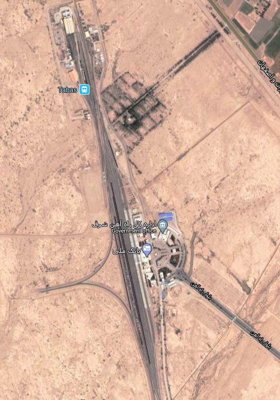
Tabas Railway Station is sited to the Northwest of the city (Google Earth).
Leaving Tabas, the line heads North-northwest for a distance, passing through a small station at Dehshour before once again turning towards the Northeast and then leaving South Khorasan Province and entering Rasavi Khorasan Province.
The railway line runs into more mountainous territory once again and almost immediately passes through a long tunnel. It then crosses further open plains near Neygenan. A view typical of this area can be found below the satellite images of Tabas Station.
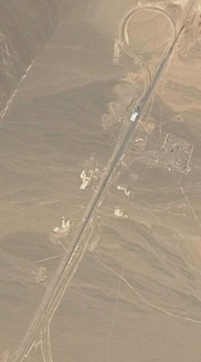
After some distance the line passes under Route 87/91 and through the adjacent railway station pictured in the landscape satellite image further below.
A closer view of Tabas Station (Google Earth).
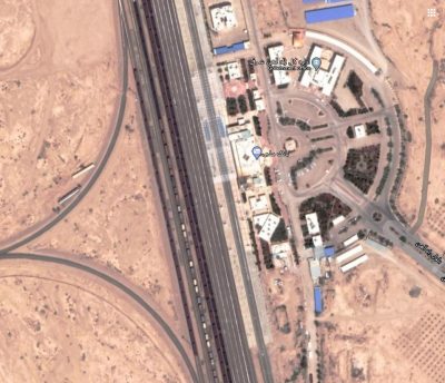
Before the railway passes under Route 95, the surrounding land begins to be more cultivated. The line then passes to the Southeast of Mehneh and follows Route 95 towards Torbat Heydarieh Railway Station.
The Station at Torbat Heydarieh is also shown on a satellite image below.
After passing under Route 36, the line heads in a northerly direction, looping round to gain height as it once again enters hilly terrain and then follows Route 95 once again. After a time in the mountains the railway line returns to relatively flat land. It passes Fathabad before once again entering the hills.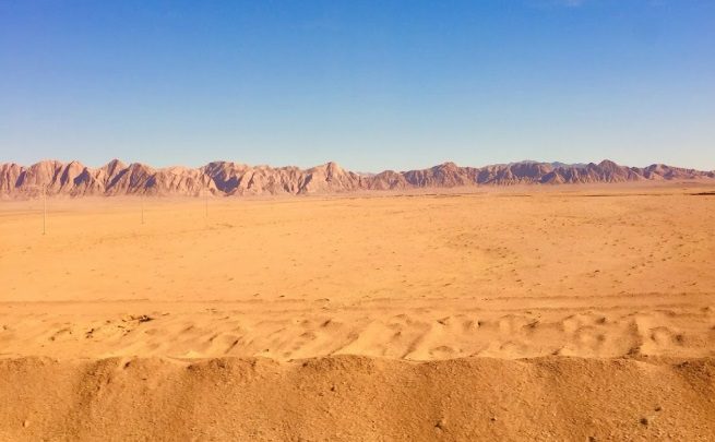 Open plains near Neygenan. [25]
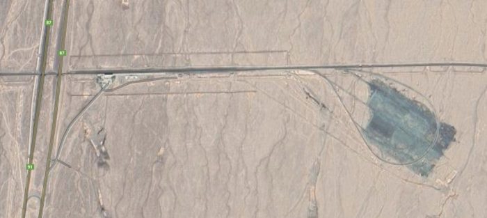 Route 87/91 and its adjacent railway station (Google Earth).
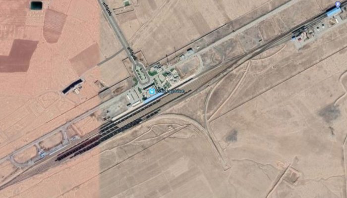 Torbat Heydarieh Railway Station (Google Earth).
Closing in on its destination of Mashhad the line encounters a triangular junction close to Dizbad Pa’in. At Dizbad Pa’in, the line heading North West through Dizbad Railway Station heads for Neyshabur and the North. That running to the Southeast heads for Mashhad. 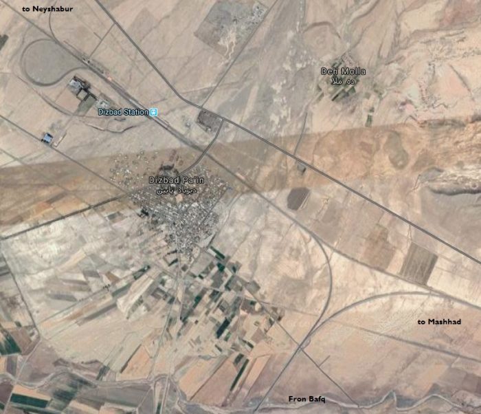
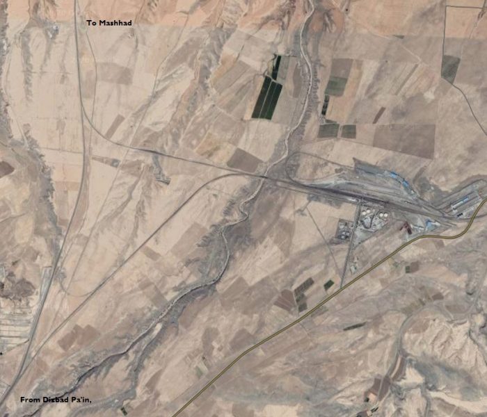 Triangular junction east of Dizbad Pa’in and south of Mashhad (Google Earth).
Between Dizbad Pa’in and Mashhad, a further triangular junction sees the line to Mashhad continuing North and a line to Turkmenistan heading East. Almost immediately, trains travelling East enter Martyr Motahhari Railway Station shown on the satellite image below. The line passes through the mountains and on to Sarakhs and over the Garagumskij Canal in Turkmenistan. [22]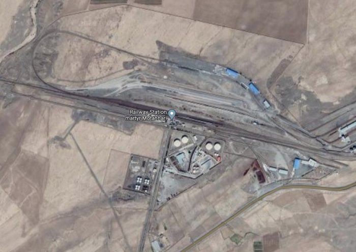 Martyr Motahhari Railway Station (Google Maps).
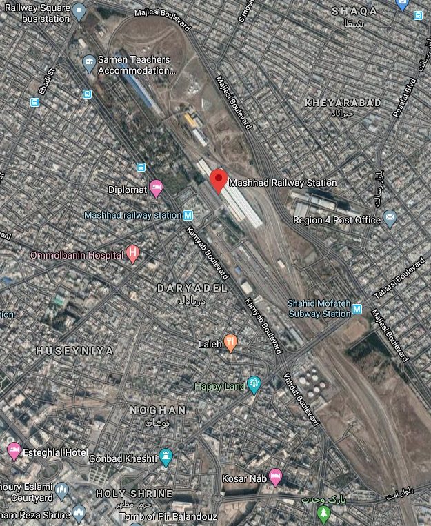 Mashhad Railway Station (Google Maps).
The line terminates at Mashhad, and, rather unusually for Iran, the station is well within the city limits.
2. Kerman to Zahedan via Bam: Construction started on the line from Kerman to Bam (225km) in 1999 and was finished in 2002. The 546km line from Bam to Zahedan was started in the year 2000 and finished in 2009. In a previous article we noted that Kerman‘s population was 821,394, in 221,389 households, making it the 10th most populous city of Iran.[15]
Wikipedia comments: “Kerman is … the most important city in the southeast of Iran. It is also one of the largest cities of Iran in terms of area. Kerman is famous for its long history and strong cultural heritage. The city is home to many historic mosques and Zoroastrian fire temples. [28]
Bam‘s popluation at the 2006 census was 73,823, in 19,572 families. [15] Before the 2003 earthquake, Bam had gradually developed as an agricultural and industrial centre, and until the 2003 earthquake was experiencing rapid growth. In particular, the city is known for its dates and citrus fruit, irrigated by a substantial network of qanats (gently sloping underground channels transporting water from an aquifer or water well to surface for irrigation and drinking). [30]
Zahedan is the capital of Sistan and Baluchestan Province. At the 2016 census, its population was 587,730. [31]
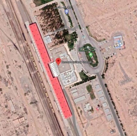
Kerman Railway Station (Google Maps)
The new line set off from Kerman Railway Station in a Southerly direction, heading for Reyan. The Railway Station at Reyan is on the Northeast side of the town.
From Reyan, the line heads South-southeast before later turning due East, then Southeast, then East again to head for Bam.
Bam Railway Station is well outside the town limits to the South. The line so far has been relatively level.
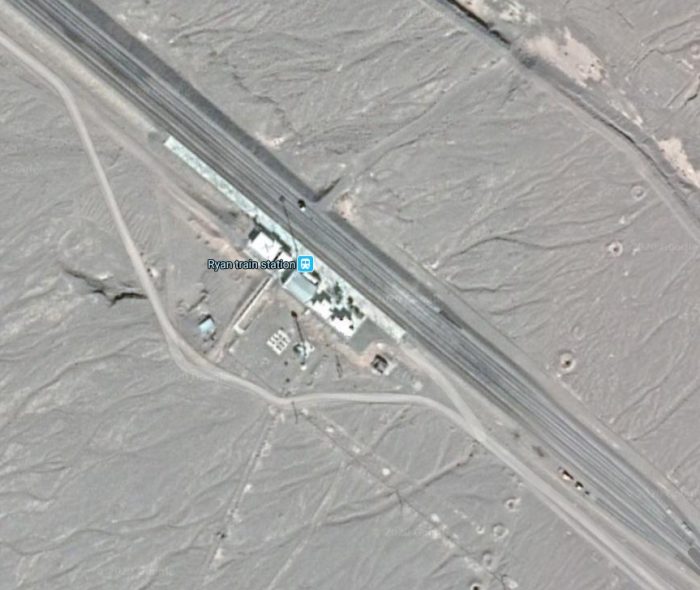
Reyan (Ryan) Railway Station (Google Earth).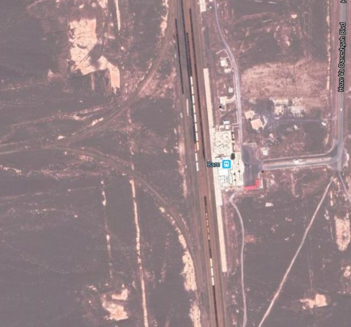 Bam Railway Station (Google Earth).
Beyond Bam the railway turns East. It passes under Route 84, the Bam-Narmashir Road and then follows Route 84 (now the Zahedan-Narmashir Road) on its Northside to the state boundary. The line then enters Sistan and Baluchestan Province and leave Route 84 behind. It crosses open country gradually drifting slightly to the North of East before it encounters mountainous country. The line follows river valleys, first Northeast, then in an Easterly direction, but with tight curves and steep grades, and then predominantly in a South-southeast direction still in mountainous country towards Shuru.
The railway leaves the mountains close to Shuru and then follows the Zahedan-Shuru Road, often switching from one side to the other of the road, to meet Route 95 beofre following Route 95 until close to Zahedan, where the line turns directly East and runs across the South side of the city.
The line runs due East across the south side of the city and then connects with the old line which served Zahedan’s Central Station – the old line linking with Pakistan. The two images immediately below show the old railway station at Zahedan.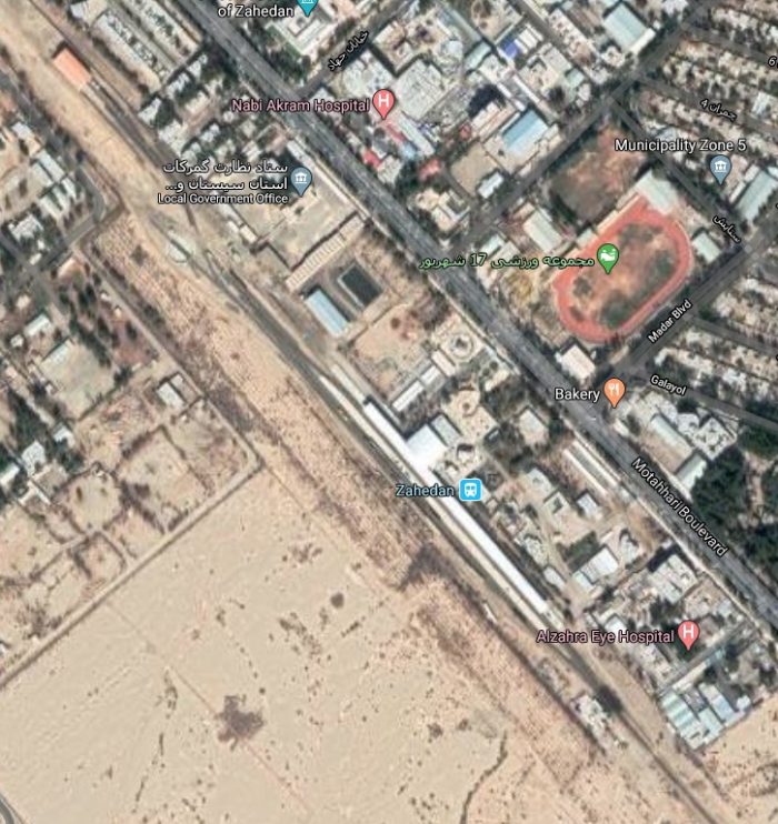 Zahedan’ Central Railway Station. One of a few which relies on a turntable to turn locomotives rather than a triangle (Google Maps).
 Zahedan’s Central Railway Station – The view from the concourse. [32]
There is a newer station to the South of the City just to the West of the point where the line from Bam meets the line which heads off to Pakistan. This station is shown on the satellite image below.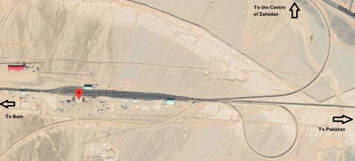 Zahedan Railway Station (Google Maps).
3. Isfahan to Shiraz – Isfahan is almost precisely due South of Tehran. We have noted before that it is the third largest city in Iran with a population of more than 2 million people. [33] Shiraz is the fifth-most-populous city of Iran . It has a population of around 1.9 million and is one of the oldest cities of ancient Persia. [34]. The size of the population of these two cities suggests that a railway line linking the two makes economic sense, particularly given that otherwise Shiraz would have remained isolated from the rail network in Iran.
As we have already seen, the station at Isfahan is a terminus trains all leave the station heading to the Northeast before turning south to a junction with the inter-regional lines. We have already followed a line West from Isfahan to Zarrin Shahr. [35] The route to Shiraz takes that line as far as Seyd Abad Railway Station. Then, immediately south of Seyd Abad Railway Station a junction allows the railway to Shiraz to head East back towards Route 65 (the Isfahan-Shahreza Expressway). The road and railway share the same corridor to Shahreza.
Shahreza Railway Station is situated on the Southwest side of the city, immediately adjacent to the Ring Road (Route 65) and the line and road continue roughly together to the Isfahan Province boundary and then enter Fars Province. The line follows along the Southwest side of Route 65 (now the Shahrez-Abadeh Expressway) to Abadeh Railway Station and then passes under Route 78 (Eqlid-Sumaq Road) and heads through open country to meet Route 65 (now the Abadeh-Safashahr Expressway) again.
South of Safashahr Railway Station the line runs on the East side of Route 65 (Sa’adatshahr- Safashahr Expressway) before heading away to the South-southeast and then South across the Qaderabad-Harat Road and then through open country in a westerly direction before running for a short distance alongside the Qaderabad Road before following Route 65 (Sa’adatshahr- Safashahr Expressway) into Sa’adat Shahr railway station. From there the railway stays alongside Route 65 (now the the Marvdasht-Sa’adatshahr Expressway). The line and road trun south for a short distance before they separate temporarily. The railway curves away to the West through an outcrop and then emerges from a short tunnel and back to align with Route 65, adjacent to a village called Khalaftahuneh. It then heads generally in a Southwesterly direction towards the city of Shiraz, crossing the Nahr-Azam River and entering Shiraz Railway Station.
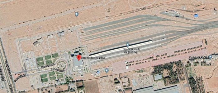
Shiraz Railway Station (Google Maps).
The picture below shows the view of the station at Shiraz on the approach from the main road.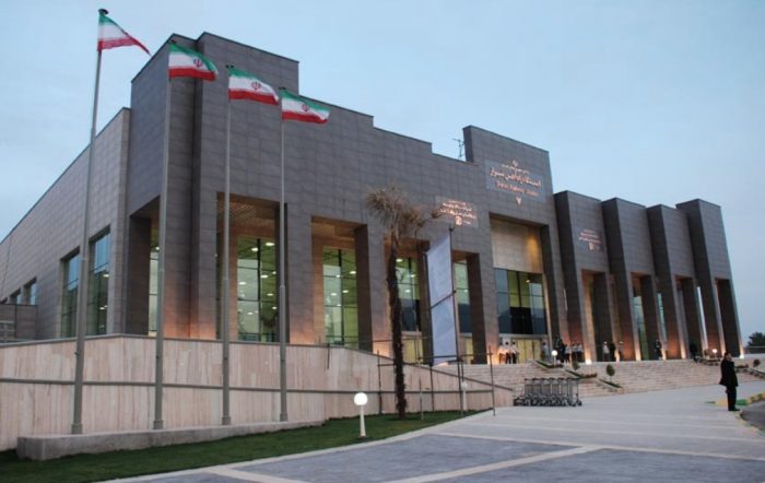 Shiraz Railway Station in 2016 (c) Hussein Karim Almaliki (Google Maps [36]
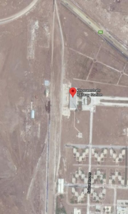 4. Khorramshahr to Shalamcheh – this is a short, 16 km length of line in the South of the country. Khorramshahr was used as an alternative port during the Second World War and a line was built from there North to join the Trans-Iranian Railway. This resulted in a significant increase in the port capacity for the supply effort to Russia during the War.
Passenger Train en-route between Khorramshahr and Shalamcheh, (Google Maps).
Khorramshahr is also known as Muhammarah. In the 2016 census its population was 133,097. It is an inland port city located approximately 10 kilometres (6.2 miles) north of Abadan. The city extends to the right bank of the Arvand Rud waterway near its confluence with the Haffar arm of the Karun river. [37]
Shalamcheh is situated on the border with Iraq, north-west of Abadan. The town was one of the main sites of invasion of Saddam Hussein’s Iraq in the Iran–Iraq War. Some 50,000 Iranians died in the fighting around the town, and there is today a war memorial in their memory. [38]
The line West from Khorramshahr appears to be truncated some distance short of the border at Shalamcheh with no evidence of more than a single line running to a terminus and no obvious station. However, Google Earth’s imagery close to the border comes from 2004 while only a short distance to the East the imagery comes from 2016. The line is visible in the 2016 imagery and, unsurprisingly (as it was built between 2009 and 2012), not visible on the 2004 imagery.
There are plans at present (2019/2020) to extend this rail link to Basra in Iraq. [39][40][41][42] This would create a rail corridor running between Iran and Syria.
5. Gorgan to Incheh Borun
Gorgan lies approximately 400 km (250 mi) to the north east of Tehran, some 30 km (19 mi) away from the Caspian Sea. In the 2006 census; its population was 269,226, in 73,702 families. [15][43]
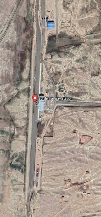
Incheh Borun is little more than a small town on the border between Iran and Turkmenistan. At the 2006 census its population was 1,764, in 334 families.[15][44] Its station is about 1 km Northwest of the small town.
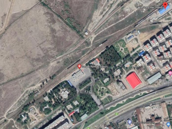
Gorgan Railway Station (Google Maps).
 The line from Gorgan to Incheh Borun forms part of the Kazakhstan – Turkmenistan – Iran transit corridor east of the Caspian Sea which is being developed under a 2007 agreement between the three countries. The section within Kazakhstan was opened on 11th May 2013, and the Turkmen section was under construction in 2013. Bogie changing facilities are to be provided at the break of gauge in Incheh Borun. [22] The Iranian section, a length of 80 km (50 miles) was completed in 2013. The full line was opened in 2014. [45]
The line from Bandar Torkaman travels East to Gorgan. Around 15 to 20 km short of Gorgan there is a junction. The line into Gorgan continues Eastward and the line to the border turns to the North and follows Route 73 to Incheh Borun.
Transfer facilities are provided at Incheh Borun to allow for the change of gauge between the two countries. Iran uses the international standard gauge of 1,435 mm (4 ft 8 1⁄2 in). Turkmenistan and Kazakhstan use the Russian standard gauge of 1,520 mm.
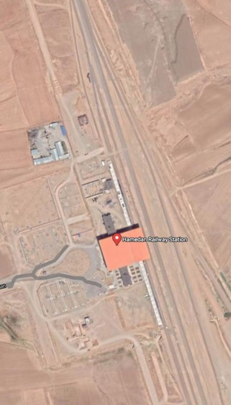
6. Tehran to Hamedan (Hamadan)
Hamedan (Hamadan) is believed to be among the oldest Iranian cities. It is possible that it was occupied by the Assyrians in 1100 BCE; the Ancient Greek historian, Herodotus, states that it was the capital of the Medes, around 700 BCE. At the 2016 census, its population was 676,105 in 210,775 families. [46]
 Construction of the line between the two cities was started in 2001 but not finished until 2017. [5] Work stopped in 2004 before being restarted after the easing of sanctions in 2015. [23]
Hamedan Railway Station is sited some distance Northeast of the city itself. The line now continues South of Hamedan for no more than a kilometre. I guess to allow for future expansion of the railway network.
Just North of the station a junction allows for trains to travel towards Tehran (first heading North) and for a route travelling in a Northwesterly diirection which at the time the Google satellite images were taken in the first quarter of the 21st century was under construction.
The route to Tehran first heads North for some 15 to 16 kilometres before running parallel to Route 37/48 in a Northeastlerly direction, and then parallel to the Saveh to Hamedan Freeway (No. 6) in a more easterly direction. It passes under Route 47 and continues to follow the same transport corridor as the Freeway (at times running immediately adjacent to the road. Route 48 re-appears and for a reasonable distance takes up an alignment between the Freeway and the railway. Close to Nowbaran Route 48 crosses the railway, as in a kilometre or two, does the Freeway.
The Freeway and the railway continue to follow similar paths but with the railway now on the North side of the Freeway as far as Saveh Railway Station.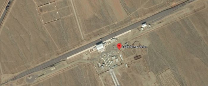
Saveh Railway Station is 6 or 7 kilometres North-northwest of the city. A little to the East of Saveh, the land begins to rise and the railway and the Freeway find their own way into the hills. Beyond this point it is the Tehran to Saveh Freeway (No. 5) that the track follows.
A line from the South meets the Tehran-Hamedan line near Parandak and from this point two lines head Northeast. The more southerly of these lines passes through Roodshur Railway Station.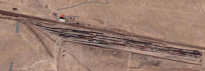 And then through a series of sharp curves to gain height while also crossing the Shur river valley.
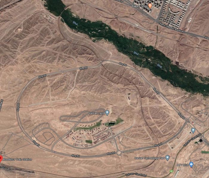 The more Northerly of the two lines climbs more steadily and in a gracefully curved bridge crosses the Shur valley.
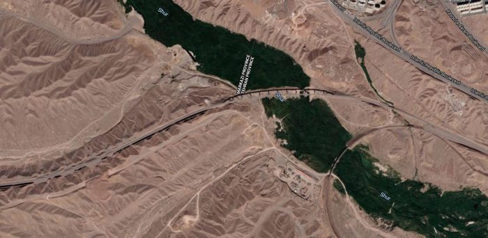 The two lines eventually come togther as they approach Robat Karim Railway Station in Vahidieh on the Southwestern apporaches to Tehran. The line then passes through Kolmeh Station and Eslamshahr Station on the southside of Aprin and on into Tehran.
7. Arak to Kermanshah
This is another line for which construction started in 2001 and was then held up by sanctions. Completion was finally achieved in 2018. It needed 175 kilometres of track laying across a difficult terrain which included building three kilometres of tunnels and seven large bridges. [24]
Kermanshah is located 525 kilometres (326 miles) from Tehran in the western part of Iran. According to the 2016 census, its population was 946,681 (and the 2019 estimate is 1,046,000). [47]
Arak has a population of 526,182, in 160,761 families. [15] The city is nicknamed the “Industrial Capital of Iran”. Arak produces around 50% of the needs of the country in steel, petrochemical, and locomotive industries. [48]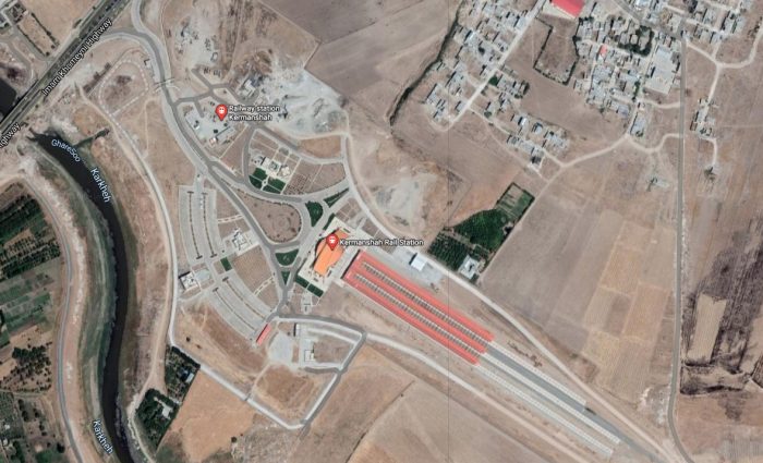
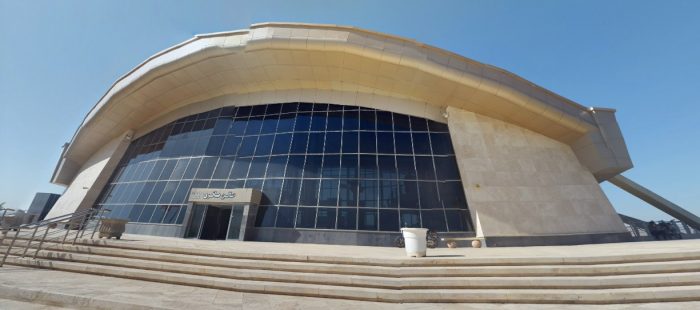
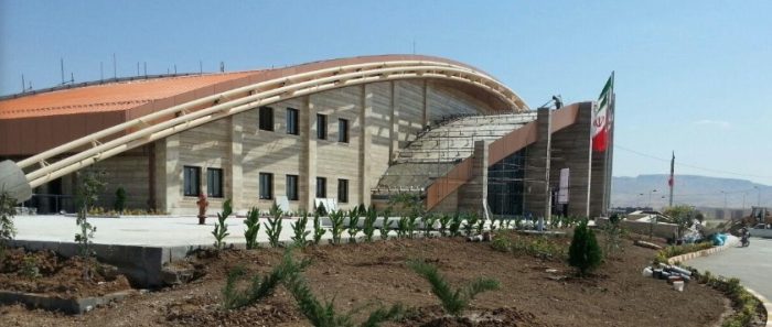 Kermanshah Railway Station (c) Mohammad Yousefvand, (Google Maps).
Kermanshah sits adjacent to the border with Iraq in Iran’s western hills. As befits a line completed in the last few years, its station is of a highly modern design.
The line from Kermanshah heads East under the City By-pass – Route 48 – and then runs parallel to Route 48 on its Southern side, crossing under Route 35 and then over the Gamasiab River near Faraash. Route 48 stays on the Western side of the river.
The railway passes from Kemanshah Province into Lorestan Province and finds itself travelling through hilly terrain. It, once again, crosses the River Gamasiab and follows its Northern slopes into the hills. In a short distance along the valley the line leaves Lorestan Province and enters Hamadan Province. Three crossings of the River Gamasiab are quickly followed by a short curved tunnel and then another bridge close to Khalenjah. Now, once again, on the North side of the river, two tunnels precede another crossing of the River Khorram Rud, a tributary of the Gamasiab.
The railway is now on the higher plateau and turns to the North, passing under Route 52 and entering another curving tunnel in which it turns to the East. The land here appears much more fertile. The line travels a distance alongside Route 52, through the Railway Station at Firuzan.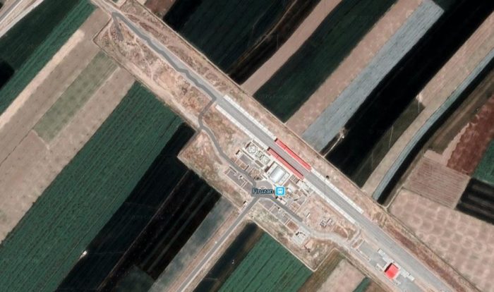 The two, road and rail, separate soon after Firuzan Station with Route 52 heading way to the South. Later the line crosses Route 37 (the Malayer to Borujerd Highway).
Malayer Railway Station (Google Streetview). Malayer Railway Station (c) Jabbar Sattari, (Google Maps).
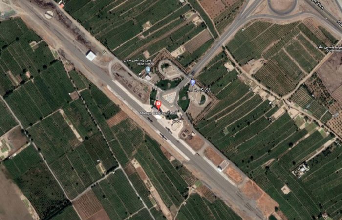 Malayer Railway Station (Google Maps).
After the Station, the Railway passes under the Arak-Malayer Highway. The Highway and the Railway then share a transport corridor past Zangeneh and Cheshme Zoragh before the railway turns South-southwest leaving the highway heading East-southeast. The line passes to the West of Jalayer and then curves sharply to the East and rejoins the Arak-Malayer Highway which when it is joined by the Arak-Borujerd Highway becomes Route 56.
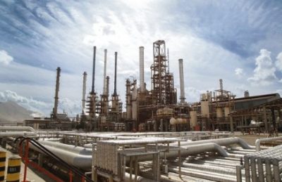
Shazand Oil Refinery (c) homayoun varzeshdost (Google Maps).
Close to Hesar and Tureh the road turns North and the Railway passes to the South of Hesar. On the North side of Akbar Abad the line turns sharply to the North, running past the Shazand Oil Refinery.
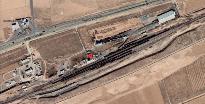
It rejoins the Arak-Borujerd Highway (Route 56) just before entering The Railway Station at Samangan.
Samangan Railway Station, (Google Maps).
The Road and Railway contiue together through Feyjan Bala and Senejan where the separate once again as the Road follows the North side of the increasingly urbanised area and the Railway, the South and then runs into Arak Railway Station.
Arak Railway Station (Google Maps).
……………………
References
- https://www.coxandkings.co.uk/destinations/middle-east/iran/private-travel, accessed on 3rd April 2020
- https://surfiran.com/iran-tour/iran-train-tour-persian-caravan, accessed on 3rd April 2020.
- https://www.farrail.com/pages/touren-engl/Standard-and-broad-gauge-railways-in-Iran-Zahedan-Mashhad-Bandar_Abbas-2019.php, accessed on 3rd April 2020.
- https://www.railforums.co.uk/threads/iran-railways.202543 (YouTube link: https://youtu.be/lqSoLVkYYu0), accessed on 25th March 2020
- https://en.wikipedia.org/wiki/Islamic_Republic_of_Iran_Railways, accessed on 29th March 2020.
- https://www.iranrail.net/network.php, accessed on 4th April 2020.
- http://in.reuters.com/article/2011/03/05/idINIndia-55349520110305, accessed on 4th April 2020.
- https://web.archive.org/web/20160318034423/http://www.tehran.ir/Default.aspx?tabid=40: http://www.tehran.ir; archived from the original on 18 March 2016, quoted in reference [10] below and noted on 4th April 2020. This article is not in English and will need translation software it it is to be read in English.
- “Tehran Metro, Iran”. Railway-Technology.com. Archived from the original on 1 July 2014; quoted in reference [10] below and noted on 4th April 2020.
- https://en.wikipedia.org/wiki/Tehran_Metro, accessed on 4th April 2020.
- https://www.farrail.com/pages/touren-engl/Railways-in-Iran-2016.php, accessed on 4th April 2020.
- M. Frybourg et B. Seiler; Globe Trotter : Des trains en Iran; Objectif Rail n°77 September/October 2016, p 68-85.
- https://en.wikipedia.org/wiki/Bafq, accessed on 4th April 2020.
- https://en.wikipedia.org/wiki/Kashmar, accessed on 4th April 2020.
- Census of the Islamic Republic of Iran, 1385 (2006); Islamic Republic of Iran. Archived from the original (Excel) on 11th November 2011 and quoted by Wikipedia in references [13] and [14] above and in references [28] and [29] below..
- “دومین شهر زیارتی خراسان رضوی”. khorasan.iqna.ir, quoted in reference 16 above and noted on 4th April 2020. This article is not written in English and will need translation software it it is to be read in English
- https://www.waze.com/en-GB/livemap, accessed on 4th April 2020.
- https://www.google.co.uk/maps/place/Choghart+Iron+Mine/@31.7003018,55.4698463,3a,75y/data=!3m8!1e2!3m6!1sAF1QipPYLmKr21Z-kKbP9-liOIvQOc7bUKvobIJgUXTI!2e10!3e12!6shttps:%2F%2Flh5.googleusercontent.com%2Fp%2FAF1QipPYLmKr21Z-kKbP9-liOIvQOc7bUKvobIJgUXTI%3Dw114-h86-k-no!7i4128!8i3096!4m13!1m7!3m6!1s0x3fa82f568572170b:0x5a1d010a9aa87c!2sBafgh,+Yazd+Province,+Iran!3b1!8m2!3d31.6216425!4d55.4139392!3m4!1s0x3fa8273801690549:0x2c64d562f8ad363!8m2!3d31.700303!4d55.4698473#, accessed on 4th April 2020.
- https://www.google.co.uk/maps/place/Choghart+Iron+Mine/@31.700303,55.4698473,3a,75y,90t/data=!3m8!1e2!3m6!1sAF1QipPMm5u7jHg1feIHONAM9Xhl8ashkIa1GQkO8Yly!2e10!3e12!6shttps:%2F%2Flh5.googleusercontent.com%2Fp%2FAF1QipPMm5u7jHg1feIHONAM9Xhl8ashkIa1GQkO8Yly%3Dw203-h123-k-no!7i1200!8i733!4m13!1m7!3m6!1s0x3fa82f568572170b:0x5a1d010a9aa87c!2sBafgh,+Yazd+Province,+Iran!3b1!8m2!3d31.6216425!4d55.4139392!3m4!1s0x3fa8273801690549:0x2c64d562f8ad363!8m2!3d31.700303!4d55.4698473#, accessed on 4th April 2020.
- https://rogerfarnworth.com/2020/04/05/railways-in-iran…rom-1980-to-1999, written in April 2020.
- https://www.tinn.ir/بخش-شرکت-ساخت-توسعه-زیربناها-16/44902-مقایسه-بهره-برداری-از-خطوط-ریلی-قبل-بعد-از-انقلاب-سال-تا-جدول, accessed on 6th April 2020 and translated using Google Translate.
- https://www.railwaygazette.com/news/infrastructure/single-view/view/iran-inaugurates-railway-to-border-with-turkmenistan.html, accessed on 6th April 2020 and quoted in reference [5] above.
- https://www.railwaygazette.com/news/infrastructure/single-view/view/tehran-hamadan-railway-opened-by-president-rouhani.html, accessed on 6th April 2020 and quoted in reference [5] above.
- https://www.presstv.com/Detail/2018/03/20/556070/Iran-railway-Rouhani-Kermanshah-Iraq, accessed on 6th April 2020 and quoted in reference [5] above.
- https://www.google.co.uk/maps/place/Neygenan/@34.302021,57.3525574,3a,75y/data=!3m8!1e2!3m6!1sAF1QipPgRSnb3niAHFzEvByGD8Qa2mGGOACPzLm0Wjgs!2e10!3e12!6shttps:%2F%2Flh5.googleusercontent.com%2Fp%2FAF1QipPgRSnb3niAHFzEvByGD8Qa2mGGOACPzLm0Wjgs%3Dw86-h114-k-no!7i1536!8i2048!4m5!3m4!1s0x3f0c40c3cad3fc83:0x4d2189b4cc1fa01!8m2!3d34.3020213!4d57.3524952#, accessed on 4th April 2020.
- https://en.wikipedia.org/wiki/Mashhad, accessed on 6th April 2020.
- “Razavi Khorasan (Iran): Counties & Cities – Population Statistics in Maps and Charts”. http://www.citypopulation.de/php/iran-khorasanerazavi.php, accessed on 6th April 2020, and quoted by Wikipedia in reference [26] above.
- https://en.wikipedia.org/wiki/Kerman, accessed on 30th March 2020.
- https://en.wikipedia.org/wiki/Bam,_Iran, accessed on 6th April 2020.
- https://en.wikipedia.org/wiki/Qanat, accessed on 6th April 2020 and quoted by Wikipedia in reference [29] above.
- https://en.wikipedia.org/wiki/Zahedan, accessed on 6th April 2020.
- https://www.google.com/maps/place/Zahedan+Railway+Station/@29.4799927,60.8749292,3a,75y,90t/data=!3m8!1e2!3m6!1sAF1QipNbAwS0nhAJvzjWZwTfWfIOo1-MRpoLjF-Ge7bY!2e10!3e12!6shttps:%2F%2Flh5.googleusercontent.com%2Fp%2FAF1QipNbAwS0nhAJvzjWZwTfWfIOo1-MRpoLjF-Ge7bY%3Dw114-h86-k-no!7i4160!8i3120!4m5!3m4!1s0x3ee7375adbd012a9:0xa702253341447988!8m2!3d29.4799927!4d60.8749293#, taken in October 2019 (c) Amin Shahraki Kia, accessed on 6th April 2020.
- https://en.wikipedia.org/wiki/Isfahan, accessed on 13th April 2020.
- https://en.wikipedia.org/wiki/Shiraz, accessed on 14th April 2020.
- https://rogerfarnworth.com/2020/03/30/railways-in-iran-part-4-1970s, published on 30th March 2020.
- https://www.google.co.uk/maps/place/Shiraz+Railway+Station/@29.7650944,52.4332488,3a,79.4y,90t/data=!3m8!1e2!3m6!1sAF1QipPJnYN2GJFLAu_822azykjx_ZAotEGghvxW83FO!2e10!3e12!6shttps:%2F%2Flh5.googleusercontent.com%2Fp%2FAF1QipPJnYN2GJFLAu_822azykjx_ZAotEGghvxW83FO%3Dw128-h86-k-no!7i929!8i622!4m5!3m4!1s0x3fb21943761b5367:0x405883f5466c3369!8m2!3d29.7641336!4d52.4314056, accessed on 14th April 2020.
- https://en.wikipedia.org/wiki/Khorramshahr, accessed on 28th April 2020.
- https://en.wikipedia.org/wiki/Shalamcheh, accessed on 28th April 2020.
- https://en.irna.ir/news/83239949/Shalamcheh-Basra-railroad-to-boom-trade-with-West-Asia, accessed on 29th April 2020.
- https://www.al-monitor.com/pulse/originals/2018/11/iran-iraq-syria-railway.html, accessed on 29th April 2020.
- https://theiranproject.com/blog/2019/03/12/shalamcheh-basra-railroad-to-boom-trade-with-west-asia, accessed on 29th April 2020.
- https://ifpnews.com/iraq-syria-working-on-joint-railway-project-with-iran, accessed on 29th April 2020.
- https://en.wikipedia.org/wiki/Gorgan, accessed on 29th April 2020.
- https://en.wikipedia.org/wiki/Incheh_Borun, accessed on 29th April 2020.
- http://country.eiu.com/article.aspx?articleid=1112552295&Country=Iran&topic=Politics&subtopic=For_4, accessed on 29th April 2020.
- https://en.wikipedia.org/wiki/Hamadan, accessed on 29th April 2020.
- https://en.wikipedia.org/wiki/Kermanshah, accessed on 29th April 2020.
- https://en.wikipedia.org/wiki/Arak,_Iran, accessed on 29th April 2020.

Iran is a very nice country. I visited there about two years ago and surprised how developed they are despite all sanctions.
I am hoping you can help me. We have a family story of a relative who worked for the Pennsylvania Railroad and consulted in Persia/Iran somewhere between 1919 and 1925. He was given a large circular medallion (32 inches) by the Shaw as thanks for his work. The Medallion depicts the shaw and advisers in the middle and 14 military men in what seems to be cossack uniforms. Do you have any information about the USA consulting in Iran during this timeframe? I am now the owner of the medallion and want to nail down its history. Many thanks for time, Joanna
Hello Joanna
Best wishes for the New year.
I am sorry. I don’t have any detailed information about USA involvement in Iran in the period you mention, other than the information available on Wikipedia ….. https://en.wikipedia.org/wiki/Trans-Iranian_Railway … which I have reproduced here.
A Company from the US called Ulen was contracted to undertake work – first a feasibility study and then as part of a consortium …..
In 1924 the American company Ulen negotiated with Prime minister Reza Khan (the later Reza Shah) an agreement to do a feasibility study for a railway line Khorramshahr and the Caspian Sea. [for the following cf DeNovo, John A: American Interests and policies in the Middle East, Univ of Minnesota 1963, p 297ff via google books (https://books.google.com/books?id=VGZItY9kL0AC&pg=PA307&lpg=PA307&dq=Ulen+Iran+rail+1924&source=bl&ots=uhSbomXu28&sig=Bfp7pGYd3Nq34b6oXhpnNJSX8rg&hl=de&sa=X&ei=KnkaT72KHoyGiQLms5XcCA&ved=0CDMQ6AEwAg#v=onepage&q=Ulen%20Iran%20rail%201924&f=false)%5D
In the following years Reza who became Shah in 1925 had legislation passed in parliament which secured internal Iranian funding for the railroad project from taxes levied on consumption of sugar and other goods thus excluding a new round of external debts that had bogged down the rulers of Iran before World War I.
In further negotiations it was agreed first to construct 2 test lines starting from the northern and the southern end of the projected Transiranian Railroad in order to establish cost for an agreement on the whole line. Against competing interests from other countries the Americans decided to form a joint venture with German companies.
From 1927 an international syndicate called “Syndicat du Chemin du Fer en Perse” consisting of the American Ulen and Company and a German “Konsortium für Bauausführungen in Persien” (formed by 3 German companies Philipp Holzmann, Julius Berger and Siemens Bauunion[Pohl, 1999, pp. 189 ff]) undertook the construction of the initial test lines. The Americans brought the line from Bandar Shahpur via Ahvaz up to Dezful. The German group started from the new harbour of Bandar Shah on the Caspian coast to the foothills of the Alborz mountains at Shahi (Qaem Shahr).
The Americans terminated their contract in 1930 after delayed payments by the government resulting from a conflict with Reza Shah. [In January 1930 the Shah undertook an inspection of the American part. After heavy rains the Shah’s train twice went off the tracks and finally the tracks were washed away resulting in the king being forced to stay for days in Ahvaz until the rains subsided. Afterwards payment of due instalments stalled and Ulen terminated the contract. DeNovo p 300 f]