
Two previous posts have looked at the East Cornwall Mineral Railway.
This post concludes the story of the line by looking at the standard-gauge line which replaced the narrow gauge line. The narrow gauge line was the subject of an article in The Railway Magazine in May 1951. The standard gauge branch line was covered in the July 1951 copy of The Railway Magazine in an article by R.E.G. Read. [1]
The original article is available through The Railway Magazine archive. Membership is available as an addition to an annual subscription to the magazine.
These articles in The Railway Magazine prompt further research and they usually lead to discovery of interesting stories and information.
The rolling stock consisted of 5 locomotives, 4 first-class saloons, 12 third-class coaches and “compo.” brakes, and 52 goods vehicles. [7, (& Appendix 1)] The locomotives included: an 0-6-0T that became No. 3, “A.S. Harris”; two 0-6-2Ts, No. 4, “Lord St. Levan”, and No. 5, “Earl of Mount Edgcumbe”, a picture of this is shown above [1, p466]; one of the ECMR 1871 narrow gauge Neilson tanks, which had received a new boiler in 1899, was converted around 1908 to a standard gauge 0-4-2T, No. 2. [11]
Most of the wagons used by the ECMR on the Calstock incline and the Kit Hill incline were built in local boat yards. [6]
Bere Alston Railway Station is now an unstaffed halt situated near the village of Bere Alston in Devon, 10 1⁄4 miles (16.5 km) north of Plymouth on the branch to Gunnislake. The branch has survived in a truncated form into the 21st century, almost entirely because Bere Alston, Bere Ferrers, and Calstock are situated in an area which, for geographical reasons, has relatively poor road connections. [3]
 Bere Alston Station in April 1964: looking East towards Tavistock, © Copyright Ben Brooksbank [4]
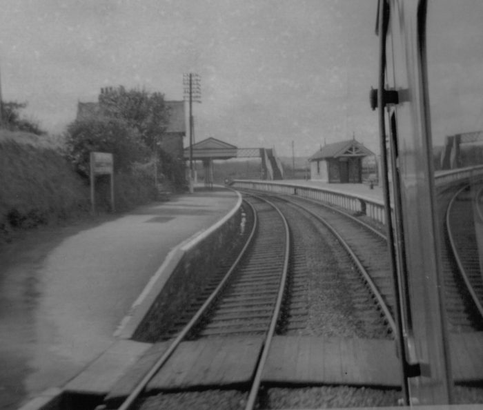 Bere Alston Station in 1970, © Roger Griffith. [20]
Bere Alston station opened 2nd June 1890, built by the Plymouth, Devonport and South Western Junction Railway (PD&SWJR) as part of the company’s line from Lydford to Devonport. Being in effect an extension of the London and South Western Railway’s (LSWR’s) main line from London Waterloo it made it possible for the LSWR to reach Plymouth independently of the Great Western Railway and as such was immediately leased to the LSWR. [5] Unlike the SDR branch, which ran from the east of Plymouth, the PD&SWJR line ran from the west of Plymouth close to the River Tamar and Bere Alston station was situated on this section of line. [13]
It was not until after the Light Railways Act was passed in 1896, that the PD&SWJR looked into a branch line to Calstock to connect to the East Cornwall Mineral Railway (ECMR). The Bere Alston and Calstock Light Railway Order was confirmed by the Board of Trade on 12th July 1900. The Order also included authorisation for the acquisition of the ECMR line and its operation as a passenger light railway, except the rope-worked incline. It was intended that the gauge would remain at 3 ft 6 in, but finance proved impossible to obtain. Eventually the LSWR was persuaded to guarantee borrowings. [5]
The Bere Alston and Calstock Railway (BA&CR) was formed as a subsidiary of the PD&SWJR, and a new Act of 23rd June 1902 authorised it to build the connecting line and to acquire the ECMR. The upgrading of the ECMR was to have been carried out under the General Manager of the ECMR, Capt. Sowton who had been in post since 1883. He lacked light railway expertise so Col. H.F. Stephens was approached and in 1904 became a consultant engineer to the PD&SWJR. In 1905 the board decided to convert the line to standard gauge (probably on advice from Stephens). [5]
The branch opened on 2nd March 1908, with stations at Calstock, Gunnislake, Latchley, Stoke Climsland (later renamed Luckett) and Callington Road (later renamed Callington, despite being a good mile from the village). A halt was opened at Chilsworthy in 1909 and another serving the Seven Stones pleasure ground existed from 1910 to 1917. All were classic Stephens’ stations and demonstrated his firm stamp on detailed constructional and operational features. [11]
There was now considerable local pressure for the railway to be extended from Kelly Bray to Callington proper, but the company would only undertake this if the land were given free. The extension was never undertaken and in 1961, the opening of the Tamar road bridge meant that a bus service from Callington to Plymouth was feasible. The poorly sited Callington station lost all purpose, but the residents of the more inaccessible villages fought the Beeching inspired cuts and gained a limited victory. Although freight trains were withdrawn on 28th February 1966 and the Callington branch was closed completely beyond Gunnislake from 7th November 1966, a Gunnislake–Plymouth via Bere Alston passenger service was retained and still continues. This is apparently the last survivor on the national network of all the Stephens influenced passenger light railways. [11]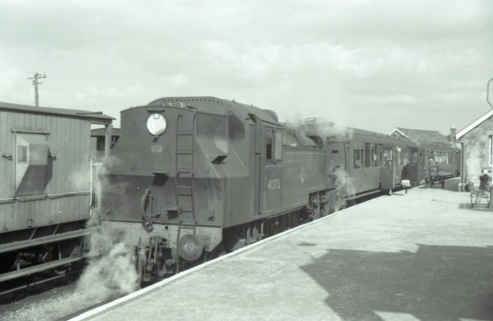 Loco No. 41275 waits with a Callington train at Bere Alston in March 1962, (c) Mike Roach. [2]
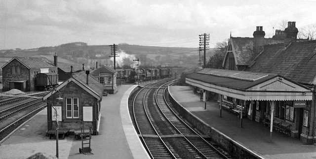
Bere Alston Station: The original PD&SWJR station had seperate Up and Down platforms on the double-track main line. To cater for the Callington branch line a new platform face was built at the back of the Up Main platform, which then became an island, although the branch platform face did not extend as far towards Tavistock as the main line side. At the Tavistock (east) end of the branch platform face was the zero mileage point for the branch. The branch approached the station from the west and at the east end of the platform it connected with the PD&SWJR Up sidings and thence the Up Main. [10]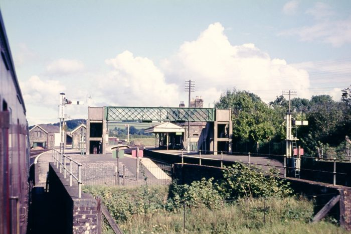 An undated picture from the Mike Morant collection taken almost certainly from a train arriving at Bere Alston from the Callington direction. [2]
Although it was possible for branch trains to run through onto the Up Main line this connection was not signalled for passenger traffic, so the branch always maintained a separate passenger service with no normal through running. The main-line signal-box stood on the Up platform near the Tavistock end, but the branch originally had its own signal-box at the Plymouth (west) end of the same platform. However the branch signal-box was closed in 1927 and its work was transferred to the main-line box, which was extended as a result. [10] Bere Alston signal diagram from 1910. [29]
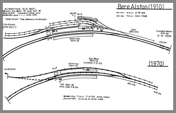 Bere Alston in 1910 and 1970. [29]
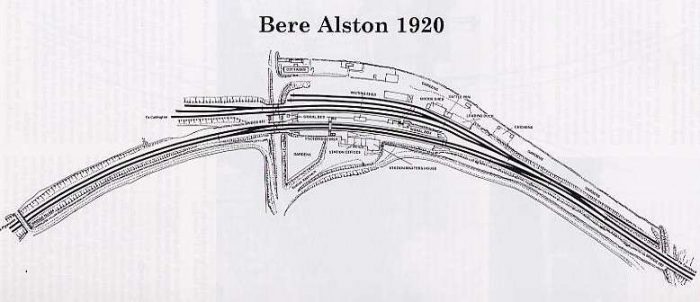 A plan of the station in 1920. [13]
During the early 1960s the freight traffic declined and steam gave way to diesel multiple units (DMUs) for the passenger service on the branch. There was talk of total closure of the branch, but the poor road access in the area meant that the railway viaduct at Calstock remained an important link across the River Tamar. But on 5th November 1966 the Callington Branch was closed completely beyond Gunnislake and the remaining section stayed open for passenger traffic only. The same year saw the closure on 2nd August of the two sidings (opened in 1908) adjacent to the branch. [13]
On the 6th May 1968 the ex-L&SWR main line beyond the east end of Bere Alston station was closed completely. This radical reduction in the railway service in West Devon left Bere Alston as the terminus of a double-track branch from Plymouth, served only by local trains. However it continued to function as a through station rather than a terminus, because the passenger service was revised so that all trains ran through from Plymouth to Gunnislake with a reversal at Bere Alston. [13]
With the disappearance of freight traffic all the remaining sidings at Bere Alston were removed, along with the branch run-round loop, leaving only a plain single-line on the branch side of the Up platform. The branch now made a simple trailing connection direct with the former Up Main, but the directions were re-named so that the line was now ‘up’ to Plymouth rather than ‘down’. [13]
Down DMUs from Plymouth arrived at Bere Alston and stopped at the former Up platform, then pulled forward and reversed onto the branch. In the return direction the DMU ran off the branch onto the old Up main, then reversed across the eastern crossover onto the old Down main and ran back to Plymouth. [13]
On 7th September 1970 Bere Alston signal-box was closed and the main line to Plymouth was reduced to a single track serving the former Down platform, which is now the only one in use. The branch was re-aligned to make a new junction at the south end of the former Down platform and the junction is now controlled by a 2-lever ground-frame, which is released by a key on the single-line train staff and worked by the guard. After this re-arrangement the island platform was taken out of use and the footbridge demolished. [13]
During the 1970s and early 1980s, Bere Alston station suffered from the neglect that afflicted so many rural railways. All the railway staff were withdrawn and the station was boarded-up, although the former station-master’s house remained in use as a private dwelling. [13]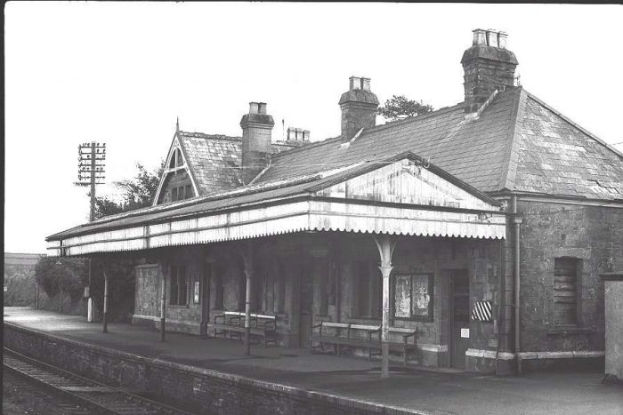 The Bere Alston Station Building in the 1970s, showing general dilapidation. [13]
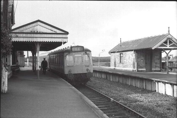 Looking West towards Plymouth in the 1970s. [13]
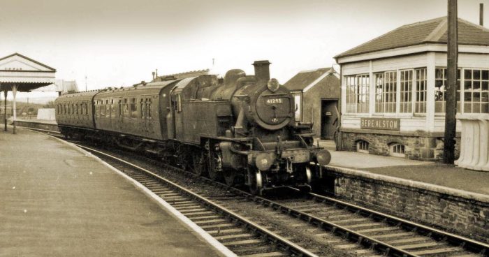 Loco No. 41295 at Bere Alston in the 1960s, before the station became the end of the main line. [19]
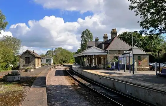
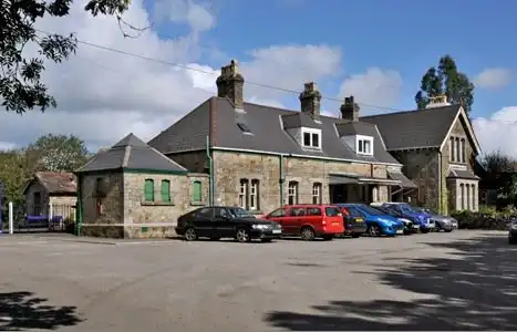 Two images of the station in the early 21st century. [29]
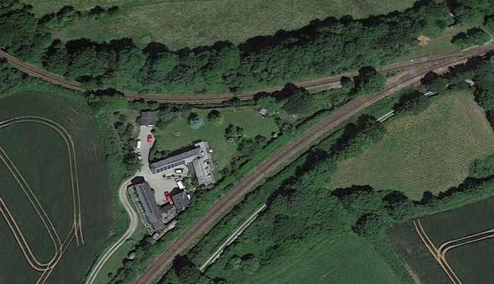
New British Rail ‘corporate image’ signs and paint appeared, but soon faded and the station slowly rotted and rusted away until BR saw the potential of the line for tourism and rebranded it as the “Tamar Valley Line.” As a result the station was eventually repainted. The former signal box and the waiting shelter survive for use by the Engineers’ Department and indeed the signal-box was refurbished in recent years. Sadly however the former goods yard remains an area of dereliction. [13]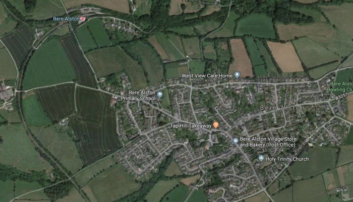 Bere Alston Station is some distance from the village. This Google Earth satellite image shows both village and station. The line of trees to the East of the station is the route of the old mainline and the possible route of any new line constructed in 21st century (see the map below). The line to Plymouth runs down the West side of the image and the line to Gunnislake leaves the image in the top left corner.
 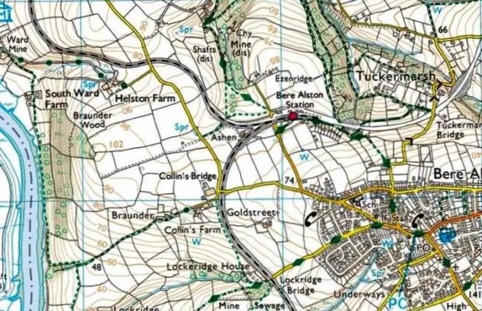 Bere Alston Station on a 21st Century OS Map. [29]
Before we head off up the line to Gunnislake, it is important to note that Devon County Council has an aspiration to re-open the railway line between Tavistock and Bere Alston and provide associated multi-use trails in the surrounding area. The re-opening of this section of line would provide a new, sustainable link between Tavistock and Plymouth for commuter journeys, help to minimise traffic on the A386, link Tavistock to the national rail network and also provide an alternative travel option for leisure, education and retail journeys. The multi-use trails will improve access to the surrounding area, which is designated as the Tamar Valley Area of Outstanding Natural Beauty and is part of the Cornwall and West Devon Mining Landscape World Heritage Site.
The scheme is a nationally significant infrastructure project due to its scale, and as such will require development consent from the Secretary of State for Transport, with the Planning Inspectorate acting on his behalf. The route is shown below. [12]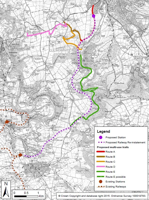 Proposed Tavistock to Bere Alston railway re-instatement and associated multi-use trails. [14]
The route of the old branch line left Bere Alston Station at its Western end and curved away North and West. At the time the 1905 OS 6-inch series of maps was being produced the branch to Callington was under construction and its embankments can be seen on the map extract below form the maps published in 1907. [15]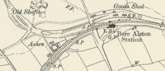
 The same location as in the 1907 OS Map above is shown in this Google Earth satellite image.
As can be seen on the excerpt from Sheet SX46NW, an OS Map from 1954, the line roughly followed the contours of the land from Bere Alston to Calstock Viaduct. [16]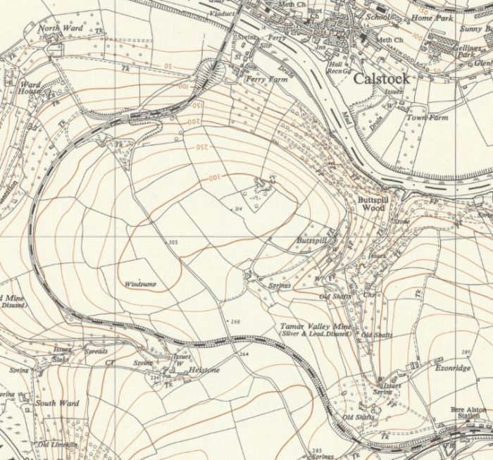 The line passed under the narrow lane shown on the satellite image below and then curves sharply round to the North and then to the East.
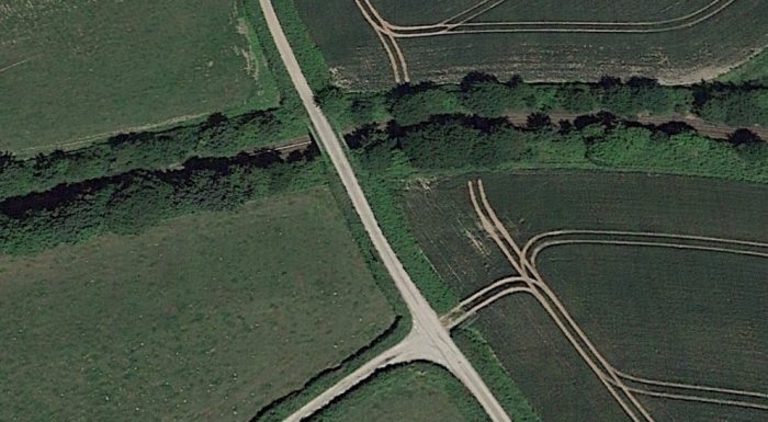 Close to Calstock Viaduct the railway passes under a road-overbridge as shown below. This isthe same road as in the picture above.
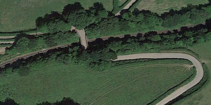
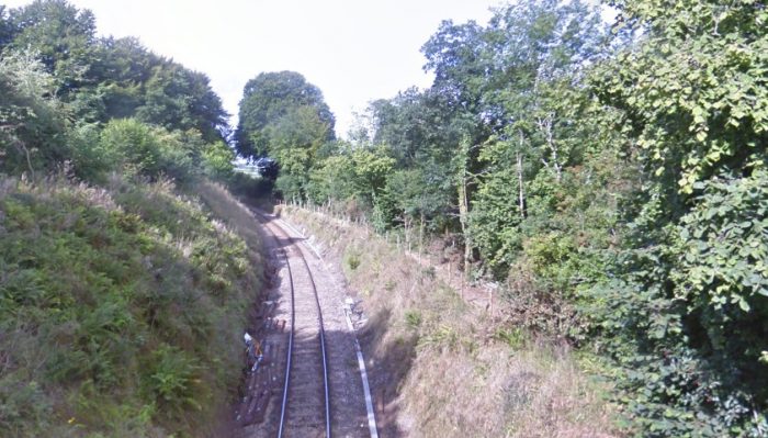 Looking back West along the line from the bridge above as it curves away towards Bere Alston.
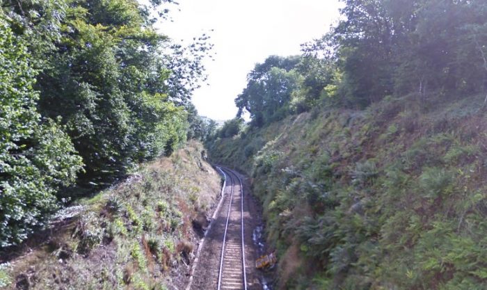 Looking forward along the line from the bridge above towards Calstock Viaduct in the early 21st century.
The line turns to the North once again and approaches Calstock Viaduct on an embankment as shown on the map [16] and photograph below.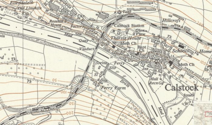
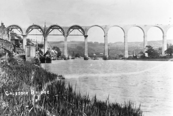
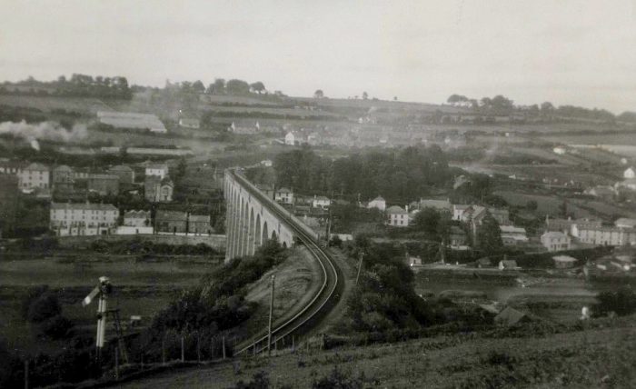 A nice view of Calstock viaduct from Devon. Note both the embankment and the fact that the home signal is down for a train from Bere Alston to run across the viaduct to Calstock station beyond, (c) Sid Sponheimer. [2]
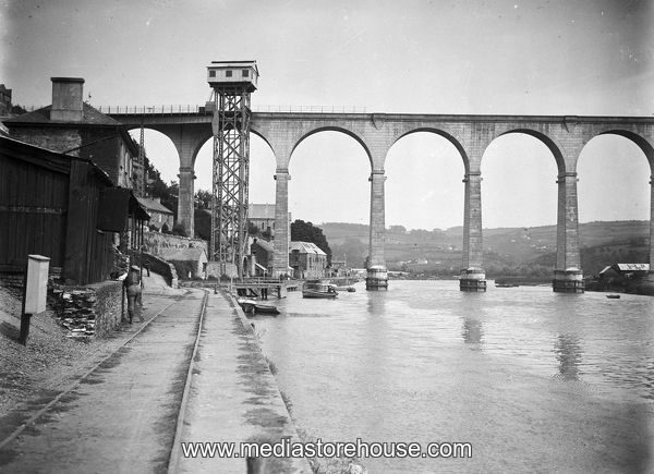
Without a doubt the finest piece of engineering on the line was the magnificent twelve arch, 850′ long, viaduct. Despite the threat of closure of the line from the 1960s, this viaduct is still carrying trains today. [8]
Calstock Viaduct: built between 1904 and 1907, the viaduct was very “cutting edge” for its day, being built from pre-cast concrete blocks that were manufactured in a temporary factory on the river bank. Some 11,000 of these, which were not reinforced, were required to complete the twelve arches. The whole thing was built to a very high standard and is as good today as the day the line over it was opened, with the concrete blocks looking just like dressed stone. [8]
The Viaduct is a Grade II* listed structure and is shown on the map below [17] on the Historic England website and described by them as follows:
 “Railway viaduct over the River Tamar. Completed March 1908; built as part of the Plymouth, Devonport and South West Junction Railway, which had bought the East Cornwall Mineral Railway in 1894. Precast concrete block, manufactured on site in the casting yard on the Devon side of the viaduct. The viaduct has twelve round arches, with rectangular plan tapered piers, in rusticated blocks, with rounded cutwaters. The arches have imposts and voussoirs, plain parapet and coping; stepped corbel between each pair of arches, forming refuges in the parapet. Built by John Charles Lang, a public works contractor of Liskeard, with engineers W.R. Galbraith and Richard Church, as part of the link line from Bere Alston to the East Cornwall Mineral Railway in Calstock. There are similarities between this viaduct and the viaduct in Poundstock, Cornwall (see Poundstock list). During construction, the blocks and other components were transported across the length of the viaduct by means of Blondins, or aerial ropeways. Until 1934, there was a remarkable vertical hoist, which was used to raise the lower tram wagons between river bank level and the viaduct.” [18]
All did not go well, though, with its construction. The builder, John Lang of Liskeard, was first of all late in arranging for the cement to be delivered, then had problems with the block making as initially they suffered from being pitted with waterholes that required filling with liquid cement. The mix included granite chippings and the supply of both these and the cement was not organised with the result that work was frequently held up whilst awaiting materials. This is probably explained by Lang’s tender for the work which, at £54,680 some £20,000 lower than the next one, was hopelessly inadequate despite his being allowed to increase it from his original figure. When the work was completed he sued for an additional £34,750, eventually settling for £15,000. [8]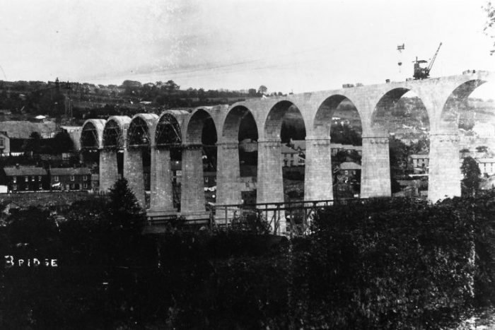
 The two monochrome images above were posted on the Southern Railway Email Group website. They show Calstock Viaduct under construction. [8]
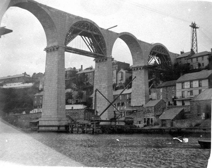 Another view of the viaduct under construction, this time from the William Gilhen Archive. [21]
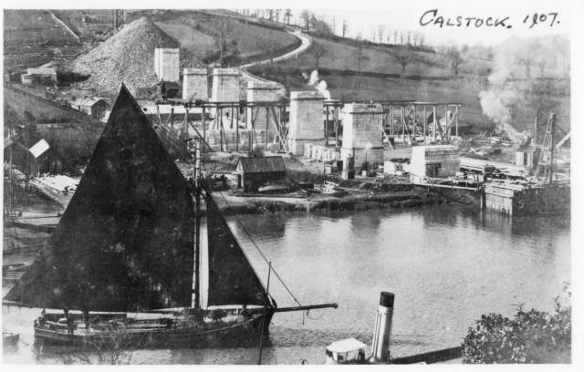 An early view of the construction of the Viaduct. [31]
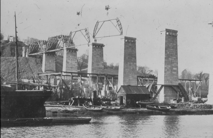 A view from Caltock towards the opposite bank of the River Tamar during construction of the viaduct. [24]
The next few pictures are a pastiche of different views of the viaduct.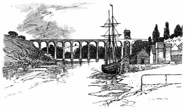 A sketch of the viaduct showing the wagon lift. The vantage point is East of the viaduct. [9, (i_023)]
 An atmospheric early morning. [22]
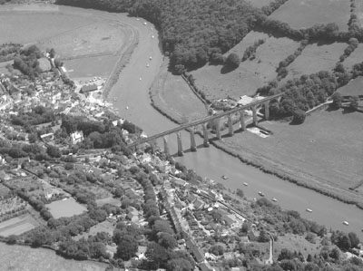
The adjacent image shows Calstock and its Viaduct from the air. [23]
The viaduct, below, crosses the tidal reaches of the River Tamar. It used 11,148 concrete blocks, cast in a temporary yard on the Devon bank. [25]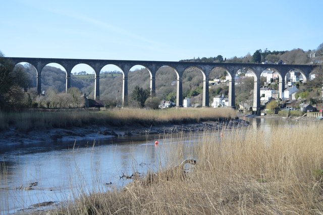
 The Calstock viaduct and quay with lift soon after completion in 1908. [26]
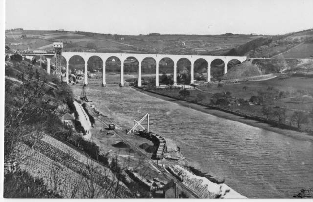 A more panoramic view showing hoist viaduct and wharf. [31]
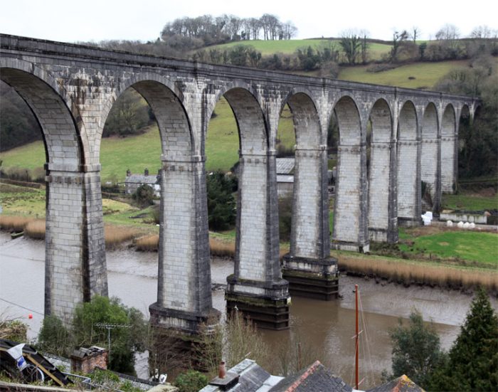 Another view from the village across to the Devon bank. Three of the piers stand in the River Tamar, which is tidal at this point and has a minimum clearance at high tide of 110 feet. [27]
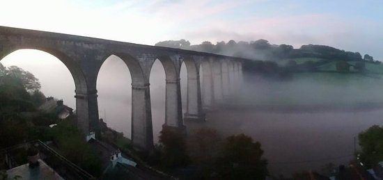 The beautiful Tamar viaduct is the focal point of Calstock village. [28]
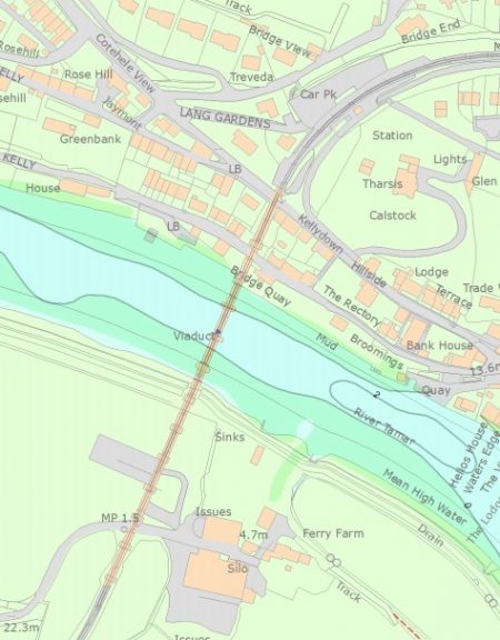
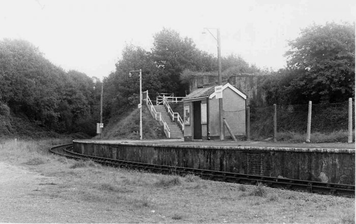
Calstock Station
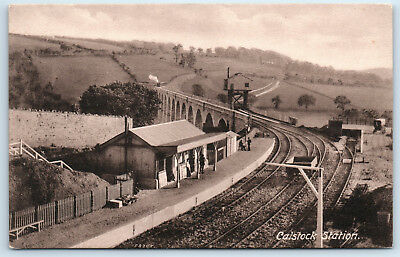 Beyond the Viaduct sits the station of Calstock which is high above the village. The first, adjacent, image shows the proximity of station and viaduct. [30]
The sequence of images below the station plan are taken from the trainwb.org website. [10] 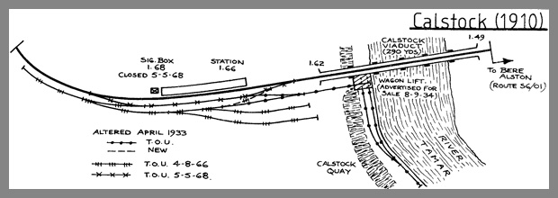 The station plan in 1910. [29]
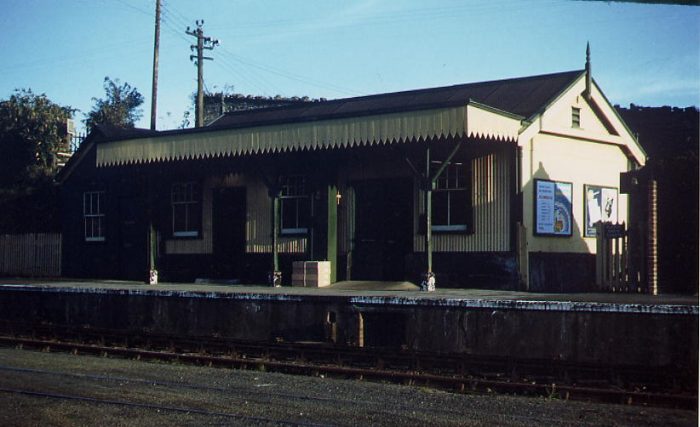
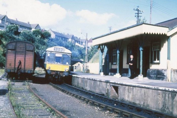

 The four images above show Calstock Station in sequence from 1966 to the late 1970s. [10]
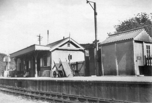 Calstock in the 1950s. [31]
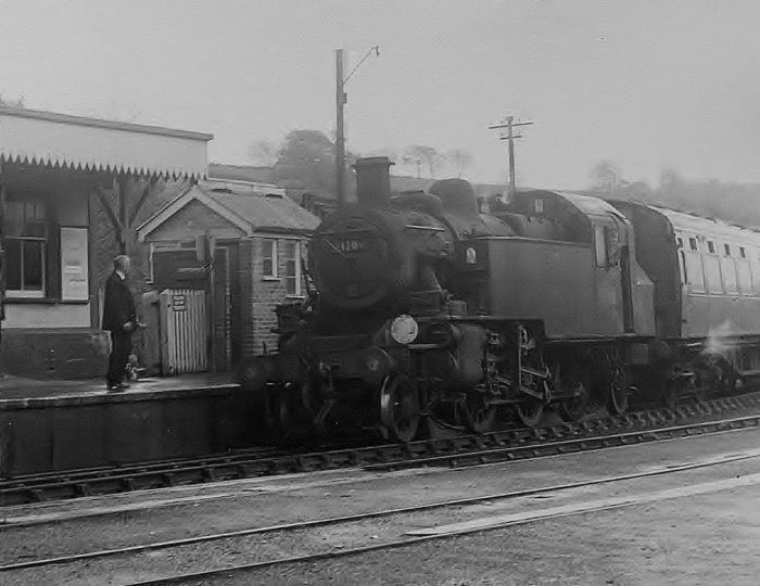
 The two images from the 1960s immediately above show: first, a service arriving at the sharply curving station platform having cross the Viaduct on its way to Gunnislake and possibly beyond.; ans secondly, a similar service taking water at Calstock station, not that this time the locomotive is travelling bunker first. [2]
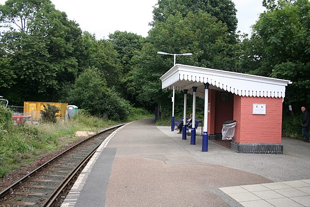 Calstock Station in 2012, © Copyright Martin Bodman. [32]
Calstock Station was situated immediately adjacent to the Cornish end of the viaduct and was on a sharp curve (right-hand for Down trains). The small ground-level signal-box was situated just beyond the Gunnislake end of the platform, adjacent to a water tank. Apart from the single platform and main running line there was a loop siding on the Down side, which gave access to further sidings. One of those sidings led to the wagon lift built at the side of the viaduct, by which single wagons could be lowered to further sidings on the Quay 112′ below. [10]
After Calstock the railway gradually gains height as it travels around the flanks of a promontory of land around which the River Tamar flows. [16]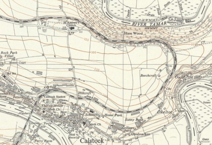 The next three images focus on a road crossing next to Eric Road – Okeltor Crossing. The location is to the Southeast of Beechcroft House on the map above. All three are source from Google Earth and Google Streetview.
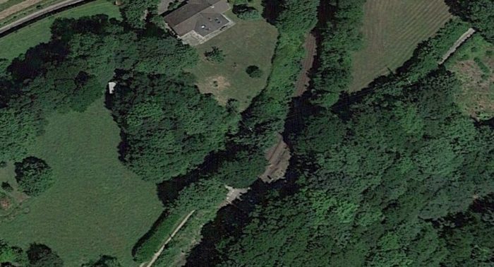
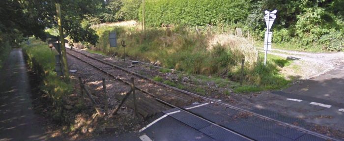
 Looking back (above) along the line towards Calstock from Okeltor Crossing.
The adjacent image was taken in the mid-1960s just a little further back down the line towards Calstock and shows a train approaching Okeltor Crossing. [2]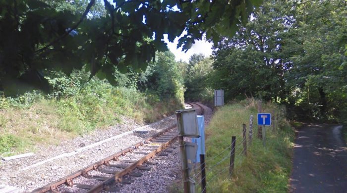 Looking ahead up the gradient facing Northeast from the crossing.
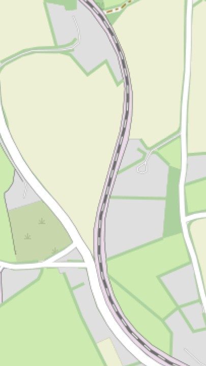
Then line turns sharply to the West following the path of the River Tamar, but at a much higher level. It passes to the North of St. Andrew’s Church and crosses two minor roads. The first as a low-headroom masonry arch bridge, the second at grade. Openstreetmap provided this map excerpt. St. Andrew’s church is off to the right of the image. the masory arch bridge just features on the right of the map.
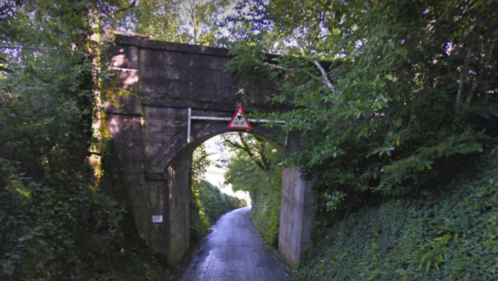 The road-under-bridge looking North.
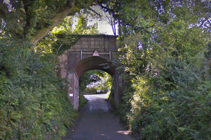 The same bridge looking South.
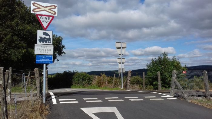 Sandiways Crossing is shown at the extreme left of the map above.
 The road-crossing on the left of the map above. The view above looks North across the crossing.
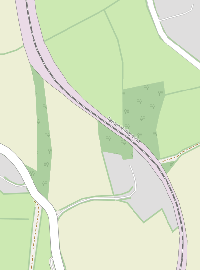
The line continues to twist through the countryside North of Calstock and adjacent the Openstreetmap excerpt and the one below it cover the last part of the new formation laid for the standard-gauge line before it joined the route of the old ECMR travelling North from the Calstock Incline.
The route of the ECMR can be seen entering the second map from the bottom as a dotted line which leads in a linear section of dark green woodland. From this poin on the standard-gauge line followed the old ECMR as far as Kelly Bray. The route can be followed in detail on another post:
There is room here, however for some more photos and maps along the route and a number of these follow below.
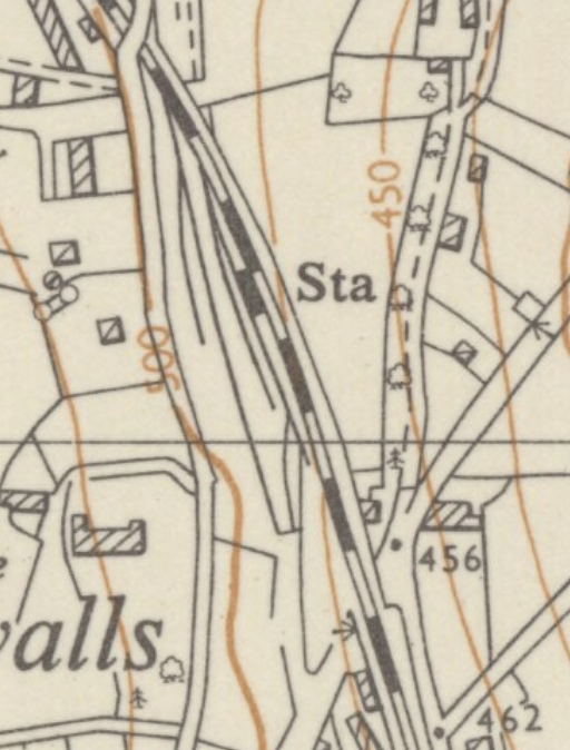
Gunnislake Station: The next significant stop on the line is Gunnislake. The old station was located a little further from Calstock than the present terminus. The earlier station’s location is shown on the 1954 6-inch OS Map just below.
Gunnislake was the only passing place on the line and unusually it had an island platform between the loops, with pedestrian access via a subway under the Down loop at the Calstock end. The station was situated a short distance to the west of the main A390 road, which it crossed by a girder bridge whose low headroom was a source of trouble to road traffic for many years. There was a goods yard on the Down side, which was served by a siding adjacent to the Down Loop accessed by a trailing connection at the Callington end. There were another two sidings at the back of the yard, which had a separate connection from the single line side at the Callington end of the station, just at the spot where a minor road crossed the line by a small girder over-bridge. [10]
On the up side there was a single siding adjacent to the Up Loop, which was accessed by a trailing connection at the Calstock end, and in later years it terminated in a buffer-stop opposite the Callington end of the platform. Originally there was also a second trailing connection from the Up Loop to this siding at the Callington end (instead of the buffer-stop), with the siding dividing into two lines which swung away from the railway – probably to serve the local Pearson’s stone quarry. It is not known when these additional sidings and associated pointwork were removed. The signal-box was located at ground level on the Up side of the line adjacent to the (later) buffer-stop of the Up Siding. [10]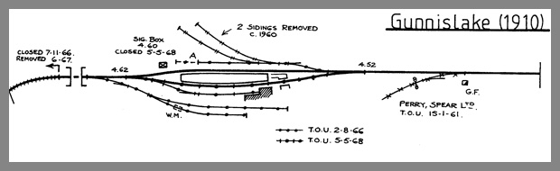 Gunnislake Station not long after opening. [29]
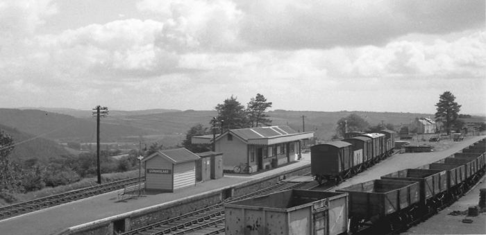 Gunnislake station taken when the branch was very much in use is courtesy the Mike Morant Collection. The view looks South towards Calsotck. Note the large number of vans and wagons in the yard. Just one car and a motorcycle combination are the only evidence of private transport other than a bicycle leaning on the station wall. If living in Gunnislake village the cyclist would have had to face a stiff climb up and a dangerous descent down. [2]
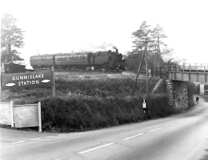 A shot of the low bridge over the A390 at the South end of Gunnislake Station as a Bere Alston bound train heads away from the well signposted station. The warning of the 12′ 4″ high bridge ahead is extremely close to the very nasty obstacle. One hopes that there were earlier warnings, (c) Sid Sponheimer. The centre of Gunnislake is nigh on a mile away down a very steep hill. [2]
On 2nd August 1966 all the goods sidings were taken out of use, except for the one immediately adjacent to the Down loop. Three months later on 7th November 1966, the branch was closed completely beyond Gunnislake and then taken up in June 1967, after which the line terminated at a buffer-stop erected just beyond the road over-bridge west of the station. Both platform loops remained in use until further changes on 5th May 1968, when the Down loop and remaining siding were taken out of use. Thereafter there was just a plain line serving the former Up platform face, whilst the buffer-stop was moved east of the over-bridge closer to the station. [10] Gunnislake in the springtime. The passing loop here was taken out of use on the closing of the line beyond this point on 7th November 1967. The very small signalbox by the buffers on the left of the picture was closed 5th May 1968. The sidings, just visible on the bottom right, were taken out of use 2nd August 1968, (c) Sid Sponheimer. [2]
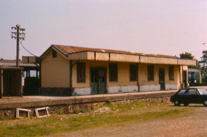 The Down side Station building in 1977 just before demolition. [10]
The station building was demolished in the late-1970s and replaced by a small concrete shelter, which itself was replaced in due course by a glass ‘bus stop’ type structure. Part of the former Down Sidings and Down Loop area was converted into a car park for rail passengers. This general arrangement remained in use until the new station was opened at Gunnislake in 1994, after which the old station site was redeveloped for housing in 2003. [10]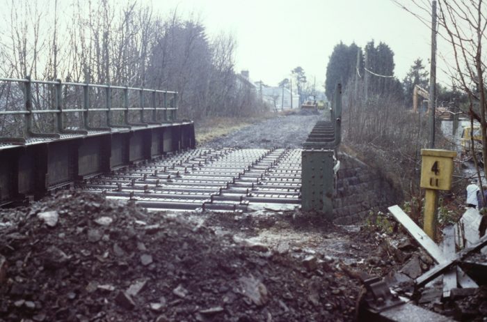
 The low headroom bridge on the A390 is shown above in the last days before its removal. [2]
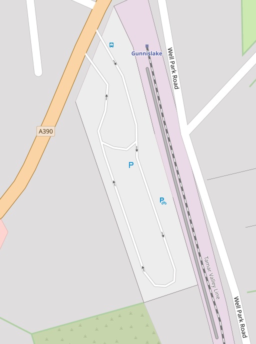
The adjacent Openstreetmap excerpt shows the location of the new station in relation to the A390. As noted elsewhere the new station was finished and became operational in 1994.
The drawing below was produced at design stage and does not show the actual arrangement of parking bays in the car park.
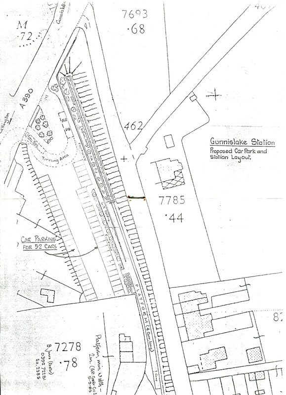 A copy of the plan of the new station as drawn by Peter Butt Cornwall Railway Society member for Cornwall County Council. [2]
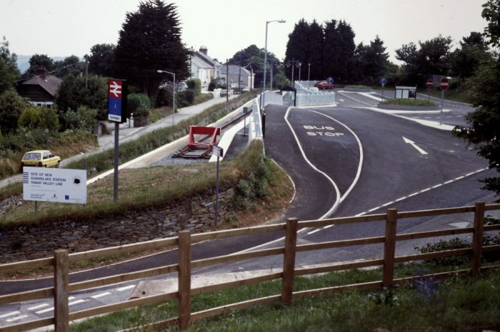 The new station on completion in 1994. The old A390 bridge is now just a memory. [2]
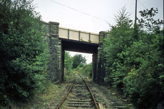 The overbridge at the North end of the old Gunnislake Station. The picture was taken in 1973 when the railway was closed just around the bend ahead towards Chlsworthy, (c) Trevor Tremethick. [2]
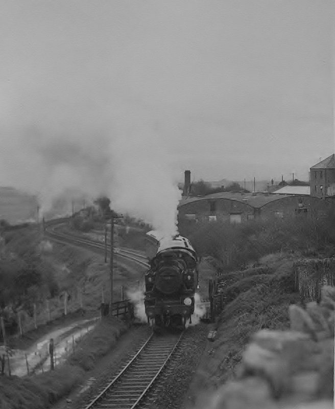 Loco No. 41309 works hard up the grade north of Gunnislake. 2nd November 1963, (c) Sid Sponheimer. [2]
Chilsworthy Halt: served the small village of the same name that was situated just below the line. This station was originally just a single platform with a small shelter on the Up side of the single line, situated just west of a minor road overbridge, but in later years there were also a number of sidings in close proximity. The station was closed on 5th November 1966 although the platform was still in existence in 2003 and the access path to it from the adjacent road now forms part of a public footpath. [10]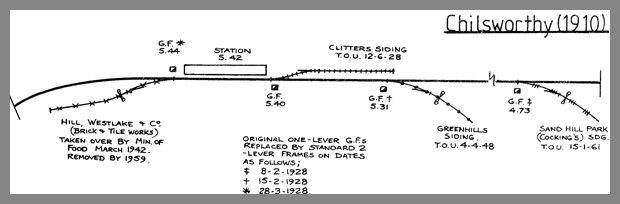 Chilsworthy Station track diagram from 1910. [29]
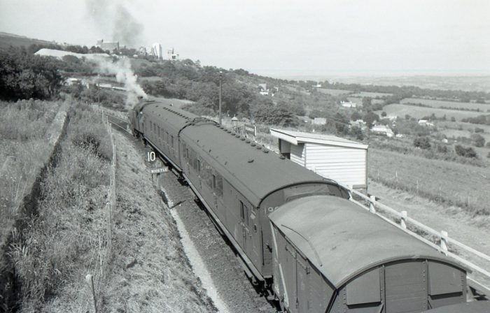 A mixed train stands at Cilsworthy Halt in 1964, (c) Mike Roach. [2]
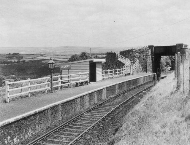 Chilsworthy Halt in the 1950s. [31]
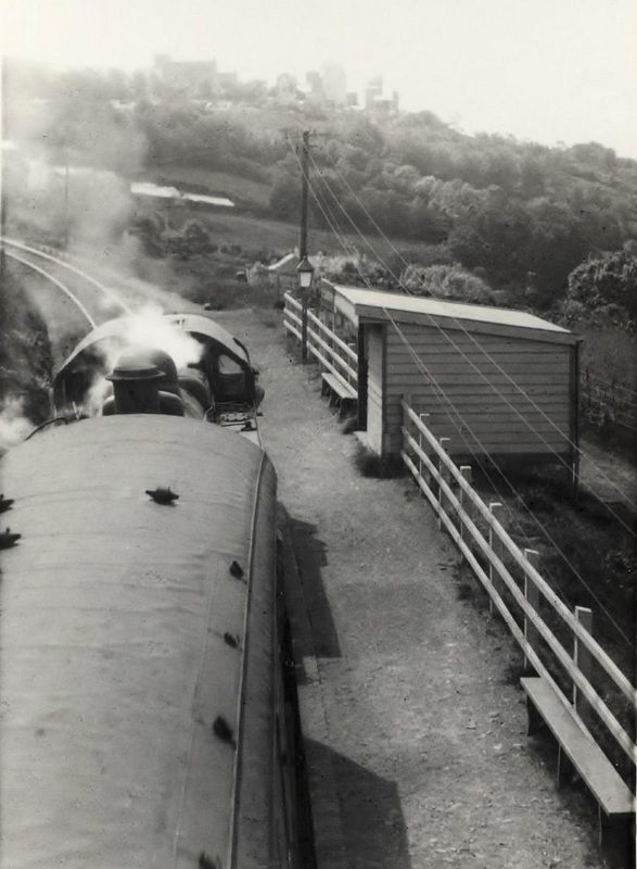
 A Callington bound train slows to a stop at Chilsworthy in the picture above. No doubt the picture was snapped from the over bridge in the photo immediately above, (c) Sid Sponheimer. [2]
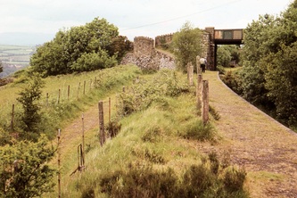
The two smaller pictures show the station after closure: first in September 1973, (c) Trevor Tremethck, and second in July 1980 (c) Peter Butt. [2]
Beyond Chilsworthy a major industrial complex was the next most significant feature alongside the line – Hingston Down Quarry. A loop and siding served the site.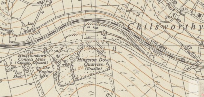 The track layout appears on the 6-inch OS Map of 1954. [33]
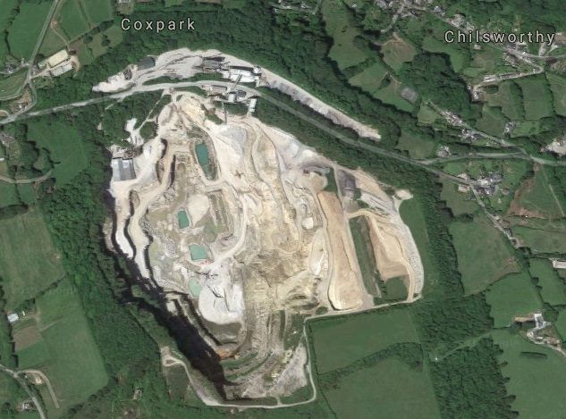 The quarry area is much enlarged in the early 21st century.
Hingston Down Quarry was still in use in 2011 the road which ran parallel to the old railway is still in place and the picture below from Google Streetview shows the quarry buildings in 2010 looking West. The old railway ran on a line which is off the the right of the picture. 
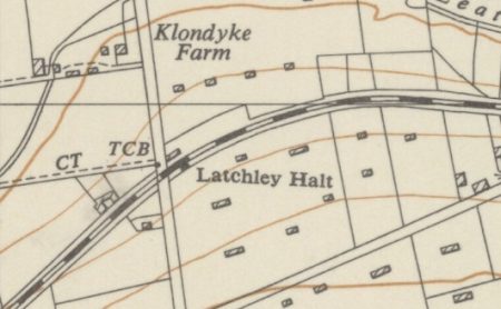 Latchley Halt: was a couple of hundred metres to the West of the Quarry and is shown on the adjacent map extract. [33]
It had a single platform on the Down side of the running line, which was recorded in 1908 as being 220′ long. Immediately west of the platform the railway crossed a minor road by an un-gated level-crossing. There was a siding on the Up side opposite the platform, which was accessed by a connection facing to Down trains at the Gunnislake end of the station. A small loading platform was located between the main line and siding in front of the main platform and opposite this again outside the siding was the stationmaster’s house and ex-ECMR goods shed. The siding was removed at some unknown date after 1950 and the station itself was closed on 5th November 1966. The station house and trackbed are now in private ownership. [10]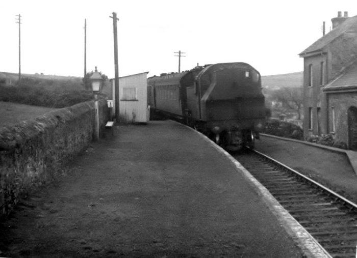
 A Bere Alston bound train enters Latchley, the train having just passed over the level crossing on the minor road to the West of the Halt, (c). Sid Sponheimer. [2]
The Halt is shown in 1949 in the adjacent image before the removal of the siding (c) P.S. Butt [2]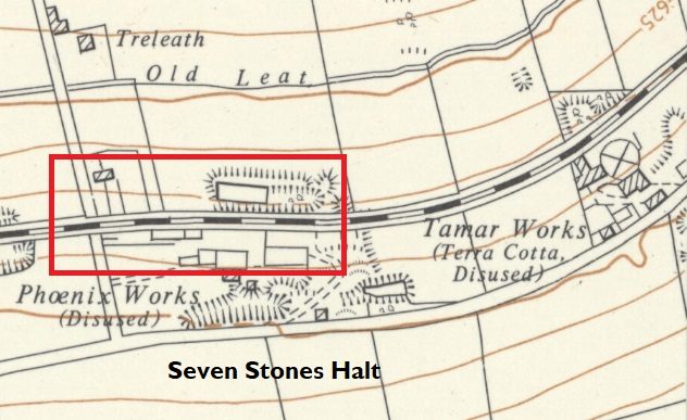
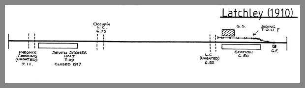 Latchley and Seven Stones Halts in 1910. [29]
Seven Stones Halt: was just a simple platform on the Down side, which was opened in 1910 in order to serve the nearby Phoenix Pleasure Grounds. It is shown on the OS Map above. [34] Sometimes it is referred to as Phoenix Mines Halt after the nearby mines, whose owners contributed to its cost. The halt was closed when the Pleasure Grounds shut during World War I, the date being given variously as 1914 or 1917. A later plan records the platform as being 140′ long. Part of the platform still remained in 2003, over 85 years since it was last used by passengers! Immediately west of the platform the railway crossed a minor road by an un-gated level-crossing. The route of the old standard-gauge line is visible on the right of the picture below, as is the old platform face of the Halt. [10][35]
 The Park opened in June 1910 and closed in September 1917 and was built by a local entrepreneur as a leisure grounds on the site of the former Phoenix Brick Works. In ECMR (East Cornwall Mineral Railway) days there may have been a siding feeding the brick works but this had gone by the time the PD&SWJR converted the mineral railway to standard gauge and passenger working in 1908. By all accounts facilities at the Park were basic with a few swings etc. Communal cooking facilities were provided for families on a day out from Plymouth. The grounds were popular with organised group outings, (usually on a Sunday) particularly church groups and the occasional political outing. Occasionally special trains were organised and on one occasion a special train was run for 400 members of the Plymouth Liberal Party. The platform still exists and this and the remains of the former brick works were the home of the Phoenix narrow gauge railway (2ft) who were quite active until asked to vacate the site in 2012. Details and pictures can be found on Bruce Hunts Blog site. [35]
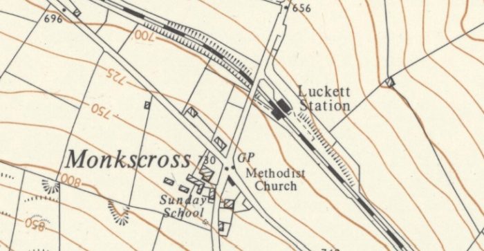 Luckett Station: [34] was known originally as Stoke Climsland. It had a 225′ platform on the Down side and a loop siding opposite it on the Up side, with connections to the main line at both ends of the station. Immediately to the west of the station the line was crossed by a minor road on a girder over-bridge. There was a further siding on the Down side at the Gunnislake end of the platform, with a connection that faced Up trains, and apparently this siding boasted a carriage shed for some years. There was originally a small ground-level signal-box here on the Up side at the Callington end of the loop, but in 1923 this was reduced to a ground-frame. A separate small ground-frame worked the Gunnislake end of the loop siding. The carriage siding was taken out of use on 31st March 1923. The loop siding was taken out of use on 23rd September 1962 and the station itself was closed on 5the November 1966. The station house and trackbed are now in private ownership. [10]
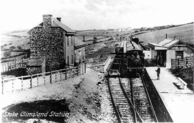 Luckett Station (Stoke Climslad Station) in the early 20th century. [31]
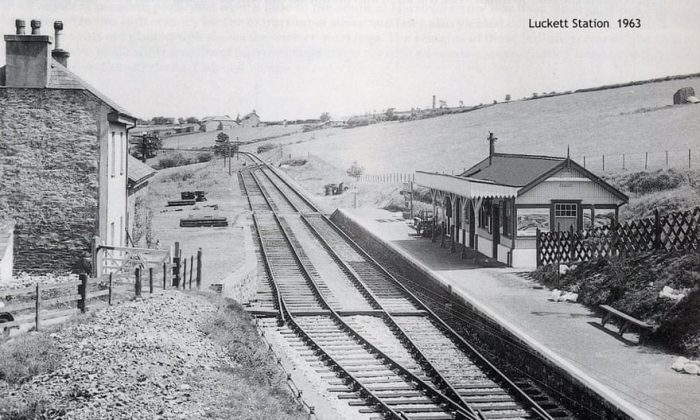 Luckett Station looking Northwest in 1963. [36]
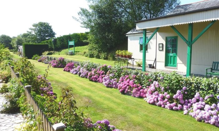 The station site is now in private hands the old track-bed is grassed but the platform shelter remains. The main station buildings have been much altered to suit their owner’s tastes. [36]
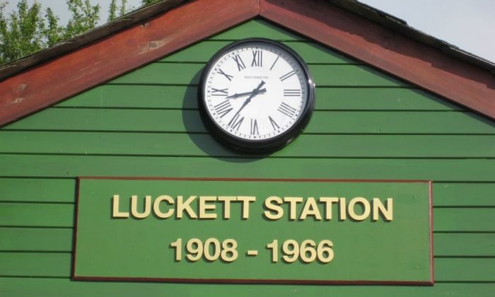 But they are still clearly old station buildings! [36]
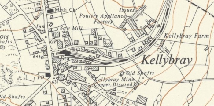 Calling the terminus station of the branch Cllington was really a bit of a stretch. There was no extension of the line to Callington beyond the original terminus of the ECMR at Kellybray! [34]
Callington Station at Kellybray: the standard-gauge’s arrival at Kellybray saw the renaming of the terminus and a significant upgrading of the station facilities. The new station was a fairly conventional terminus, with a single platform on the up side and several sidings and a run-round loop on the Down side. However the run-round loop was at the approach to the station, rather than alongside the platform, so arriving trains had to be propelled back out from the platform for the engine to run round. The ground-level signal-box was located at the Gunnislake end of the platform. Rather grandly, as befitted the main station of the Light Railway, Callington also boasted an overall roof over the station platform and main line, with an extension over an adjacent siding that was removed in later years. On the Up side of the line there was a two-road engine shed, which was accessed originally by a connection facing to Up trains close to the end of the platform. [10]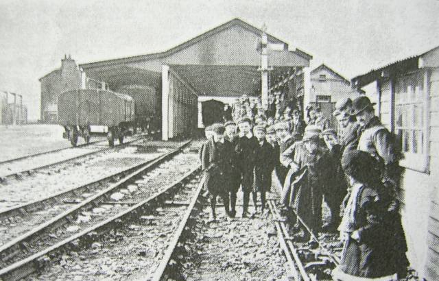 Awaiting the first ever train at Callington in 1908. [37]
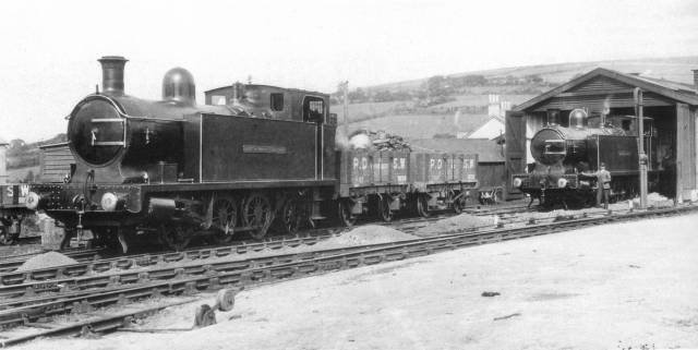 ‘Earl of Mount Edgcumbe’ & ‘Lord St. Leven’ at Callington. [31]
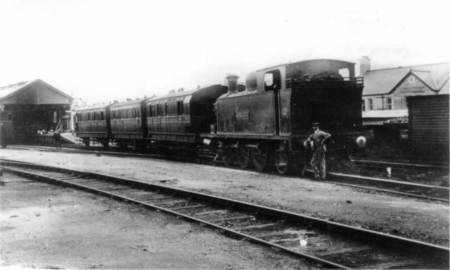 Passenger train at Callington circa 1910. [31]
A new connection (facing to Down trains) was installed in 1916 on the Up side beyond the Gunnislake end of the engine shed and this led to some cattle sidings. Further changes took place in 1928, with the modification of various sidings and alteration to the connections to the main line. In particular the existing tracks into the west (station) end of the engine shed were removed and a new access provided from the east (Gunnislake) end. The platform was lengthened by 94′ at the eastern end, which meant that the signal-box was moved one chain nearer Gunnislake. Goods facilities at Callington were closed on 28-Feb-1966 and the station was closed completely on 5-Nov-1966. The whole station site has been re-devoloped for both industrial use and residential housing, although one or two of the old buildings from the goods yard still survive. [10]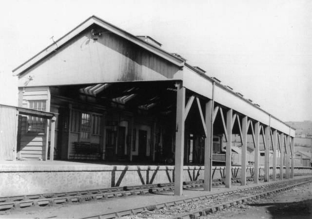 Callington station, the terminus of the branch line. [31]
References
- R.E.G. Read; From Bere Alston to Callington; in The Railway Magazine, Volume No. 603, July 1951, p481-486 & p466-467.
- http://www.cornwallrailwaysociety.org.uk/callington-branch.html, accessed on 31st March 2019.
- https://en.m.wikipedia.org/wiki/Bere_Alston_railway_station, accessed on 31st March 2019.
- https://www.geograph.org.uk/photo/1972579, accessed on 31st March 2019.
- http://great-devon-railway.uk/bere%20alston%20%26%20callington%20railway/index.html, accessed on 31st March 2019.
- Martin Bodman; Inclined Planes in the West; Twelveheads Press, Chacewater, 2012
- http://www.brucehunt.co.uk/Callington%20Tourism.html, accessed on 28th March 2019. This refers to The railway Magazine 1912. A copy of the relevant article is provided at Appendix 1 below.
- http://www.sremg.org.uk/infrastr/calstock_viaduct.html, accessed on 30th March 2019.
- http://cran.nust.na/gutenberg/4/7/7/6/47763/47763-h/images, accessed on 28th March 2019.
- http://www.trainweb.org/railwest/railco/sr/cal-stn.html, accessed on 31st March 2019.
- https://www.gracesguide.co.uk/Bere_Alston_and_Calstock_Light_Railway, accessed on 31st March 2019.
- https://www.devon.gov.uk/roadsandtransport/traffic-information/transport-planning/tavistock-to-bere-alston-railway-and-associated-multi-use-trails, accessed on 1st April 2019.
- http://www.trainweb.org/railwest/railco/sr/b-alston.html, accessed on 31st March 2019.
- https://devoncc.sharepoint.com/sites/PublicDocs/Highways/_layouts/15/guestaccess.aspx?guestaccesstoken=k7D0S%2fHZpJvn%2fAR4muVJwZGQD%2fsiQb%2bEFyT%2fX5xl9aw%3d&docid=073bf6e9bfd2a450c8bc682985efcc725, accessed on 1st April 2019.
- https://maps.nls.uk/view/101445166, accessed on 1st April 2019.
- https://maps.nls.uk/view/189247811, accessed on 1st April 2019.
- https://mapservices.historicengland.org.uk/printwebservicehle/StatutoryPrint.svc/131521/HLE_A4L_Grade%7CHLE_A3L_Grade.pdf, accessed on 1st April 2019.
- https://historicengland.org.uk/listing/the-list/list-entry/1138329, accessed on 1st April 2019.
- https://www.plymouthherald.co.uk/news/secret-plans-almost-left-plymouth-733875, accessed on 31st March 2019.
- https://commons.m.wikimedia.org/wiki/File:Bere_Alston_railway_station,_Devon,_1970.jpg, accessed on 31st March 2019.
- https://plymhearts.org/our-collections/swib/gilhen-archive, accessed on 26th March 2019.
- https://www.visitplymouth.co.uk/explore/calstock-and-the-tamar-valley-p485123, accessed on 2nd April 2019.
- http://www.calstock.info/calstock/calstock_photos.htm, accessed on 2nd April 2019. This was sourced by Caltosk.info from http://www.historic-cornwall.org.uk/cisi/calstock/CISI_Calstock_report.pdf
- https://www.communityarchives.org.uk/content/organisation/calstock-parish-archive, accessed on 2nd April 2019.
- https://www.geograph.org.uk/photo/5096389, accessed on 2nd April 2019.
- https://www.mediastorehouse.com/royal-cornwall-museum/transport/railways/calstock-viaduct-cornwall-2nd-march-1908-12419298.html, accessed on 2nd April 2019.
- https://www.gracesguide.co.uk/Calstock_Viaduct, accessed on 2nd April 2019.
- https://www.tripadvisor.co.uk/LocationPhotoDirectLink-g1414013-d12336471-i295644589-Ceramics_By_Miranda-Calstock_Cornwall_England.html, accessed on 2nd April 2019.
- http://crjennings.com/The%20Remains%20of%20Britains%20Steam%20Age%20Railway/Rems%205.html, accessed on 29th March 2019.
- https://picclick.co.uk/Calstock-Cornwall-Railway-Station-Early-1900s-RP-Postcard-163423473278.html, accessed on 31st March 2019.
- http://colonelstephenssociety.co.uk/the%20colonels%20railways/bere%20alston%20to%20calstock%20light%20railway/bere%20alston%20to%20calstock%20light%20railway%20phot%20gallery.html, accessed on 2nd April 2019.
- https://www.geograph.org.uk/photo/3034852, accessed on 2nd April 2019.
- https://maps.nls.uk/view/189247859, accessed on 2nd April 2019.
- https://maps.nls.uk/view/189247688, accessed on 2nd April 2019.
- http://www.brucehunt.co.uk/Sevenstones.html, accessed on 2nd April 2019.
- https://www.theguardian.com/money/gallery/2016/oct/14/woo-woo-a-renovated-railway-station-in-pictures, accessed on 2nd April 2019.
- http://brucehunt.co.uk/plymouth%20devonport%20and%20south%20western%20junction%20railway/callington%20branch%20opening%20day%20report%201908.html, accessed on 2nd April 2019.
Appendix 1 – The Railway Magazine – October 1912
One of the prettiest railways around Plymouth is the line of the Plymouth, Devonport and South Western Junction Company, which runs from Bere Alston station to Callington. Originally it was a narrow gauge mineral railway, constructed for the purpose of carrying minerals and stone from the various mines and quarries from Callington and district to Calstock Quay. It was bought by the Company, and worked by them for several years as a mineral line, the ultimate object being to connect it with their main line at Bere Alston, which is being worked as a part of the London and South Western Railway system. In 1908 the Plymouth and Devonport Company re-modeled the mineral line, substituting modern appliances for the old, and converting it into a standard gauge railway. They also built a costly viaduct over the river Tamar, and cut a new line from Calstock to Bere Alston station.
The rolling stock consists of 5 locomotives, 4 first-class saloons, 12 third-class coaches and “compo.” brakes, and 52 goods vehicles. Opened for traffic on March 2, 1908, the line runs through some of the most beautiful scenery in the West. There are no sulphurous tunnels, and one need not be afraid to look out of the carriage windows to admire the beauties of the district, or to inhale the fresh air from the neighbouring hills.
Two 0-6-2 tank engines, the Earl of Mount Edgcumbe and Lord St. Levan, have been doing some fine work over this small line. Some of the gradients are 1 in 38 and several of the curves are of 6 chain radius. The Tamar river is crossed by means of a fine concrete viaduct, and Calstock station is on the western side. On the viaduct a wagon lift, worked by steam, has been erected for lifting loaded and empty wagons from Calstock Quay to the running roads. The capacity of this lift is 16 tons, and the height from the quay to rail level is 110 ft.
A break of journey at Calstock will enable any persons interested in railway appliances to inspect the lift. Calstock, a small town situate on the Cornish banks of the Tamar, is somewhat unique as a parish in this part of the county. Its river scenery is unsurpassed, and unusually variegated. From the time it skirts the parish below the rural and picturesque Horse Bridge to its passage past Cotehele, we have here well wooded and gentle slopes, there beetling crags rising hundreds of feet; then a village nestling amidst rich orchards and fertile gardens; and next an island, small, but like a gem set in the silvery waters. From the tortuous river the ground rises like a series of terraces to Hingston Down, one of the numerous moors running through Cornwall. This has its natural crown and gloryin Kit Hill the highest point in the neighbourhood, whence may be seen such widely different points of the compass as Caradon, Windmill (in Launceston) the tors of Dartmoor, and Saltash railway bridge. The main road which leads to Callington is 700 ft. high, and from it the sea to the south by day and the revolving lights of Eddystone by night are clearly discernible.
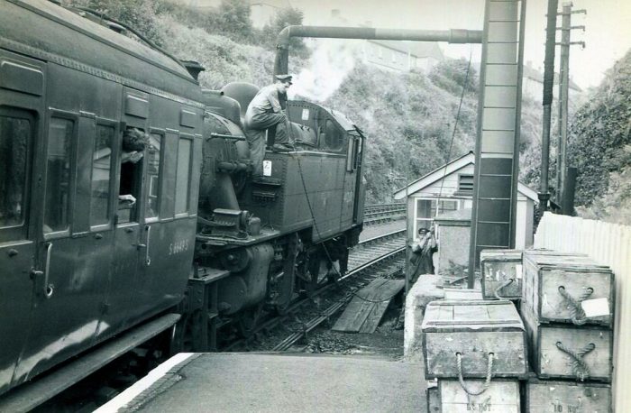
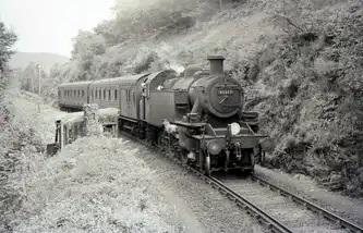
After leaving Calstock, the line begins a climb of 400 ft. to Gunnislake station, winding in and out curves of 6 chain radius. If seated in a rear carriage, a passenger can often see the 0-6-2 tank engine toiling with might and main on her way up the grade of 1 in 38 round some sharp curve.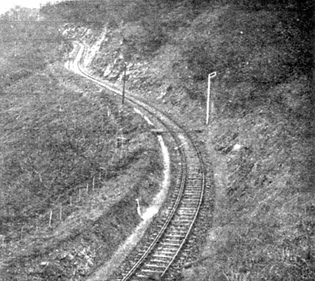 The above picture is a typical illustration of one of these curves.
Readers will note the check rail, and the fact that the line is literally cut from the side of the hill. After leaving Gunnislake, still climbing, we get fine views of Brent Tor, Latchley, and the Tamar meandering through the valley hundreds of feet below. Passing along, we come to Luckett station, where the summit of Kit Hill is within easy distance. Here we find a smart and trim lady station mistress, who, single handed, attend, to passenger, parcels and goods traffic, and is responsible for signals. Kit Hill, famous as the highest land in the district, except Caradon Hill, is at an altitude of 1,067 ft. above sea level. Situate about 1½ miles from CallingtonTown, it forms the summit of Hingston Down, whereon are seen a mine stack and buildings, as well as the remains of a large encampment, still marking the scene of a terrible battle fought centuries ago.
The remarkable pile of stones called the “Cheesewring” or “Wringcheese” — so named because they rest upon each other in cheese fashion—is situate on the common called Stowes. Comprising a large mass of granite rock 22 ft. high, these stones over- hang their base so much that the wonder. is how they remain in position. Ten in number, the stones are at the broadest place on the top about 34 ft. diameter, and at the narrowest part of the base about 17 ft. This place is an object of great interest to the tourist, and a natural curiosity. Within a mile to the northward of the Cheesewring, stands another extraordinary assemblage of rocks, termed, owing to their conical arrangement, “SharpPointTor.” The elevation is 1,200 ft. above the sea and the panoramic scenery is very fine. This, with Kilmer, is the highest point in the district of East Cornwall. Tourist and Excursion tickets are issued from all the principal stations on the London and South Western Railway to any station on the Plymouth, Devonport and. South Western Junction Railway, and the line is becoming exceedingly popular for school pleasure parties, extensive accommodation being made at the various grounds on the system.

The April 1964 photo of Bere Alston captioned “looking westward towards Devonport….” is actually looking eastwards (up the line) towards Tavistock.
Noted and updated! Thank you.
I am contacting you because your link number 8 is to what was the Southern Email Group that has changed its name to Southern Railway E-mail Group (SREmG) and its website address to: https://sremg.org.uk, with the page in question being: https://sremg.org.uk/infrastr/calstock_viaduct.html
Thank you. I appreciate you taking the trouble to make contact. I have updated the text and reference [8]
Pingback: The West Clare revisited – Hyde Park Now
Pingback: Light Railways in the UK – the early years after the 1896 Act – The Railway Magazine, August 1905. … | Roger Farnworth