

A short history of the line is followed by some information about the locomotives used on the line. This first article then focusses primarily on the horse-powered tramroad which preceded the later Penrhyn Quarry Railway.
Penrhyn is the Welsh word for ‘promontory’.
“The history of Port Penrhyn can be traced back as early as 1713 when it was recorded that 14 shipments totalling 415,000 slates had been sent to Dublin. In 1720, another 8 shipments totalling 155,000 slates were sent to Dublin, two to Drogheda (20,000) and one to Belfast (35,000). Two years later, a shipment of 80,000 slates were sent to Dunkirk. After these few shipments only coastal traffic left from Aber-Cegin (Port Penrhyn) until Richard Pennant took over the ownership of Penrhyn Estates and appointed Benjamin Wyatt in 1786 as agent.” [23]

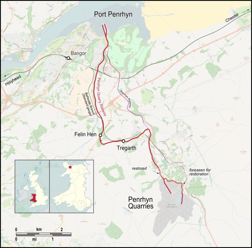
The Penrhyn Railway opened as a tramroad in 1801 which ran from quarries a few miles inland from Bangor in North Wales to the coast at Port Penrhyn. The gauge of the tramroad was 2ft 0.5in. It was constructed by Lord Penrhyn at a cost of around £175,000. [1][2] The alignment was as shown on the map immediately below.

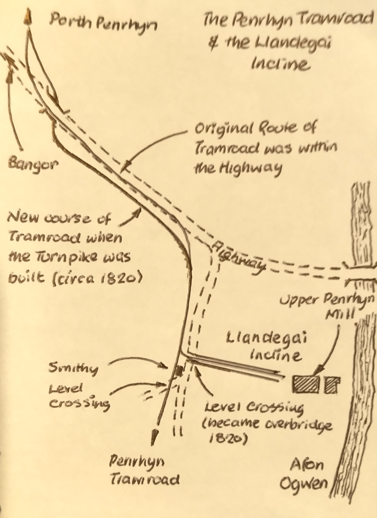
It was thought that there was an earlier line which ran between Port Penrhyn and Llandegai. That tramway, if it existed, was constructed in 1798. Its route paralleled that of the northern end of Lord Penrhyn’s tramroad. One theory is that this earlier tramway was operational until 1831. [1] There appear to have been two inclines on the Llandegai Tramway, one close to the port and the other directly adjacent to Llandegai Penlan Mill at Llandegai at the Southern end of that line. Both are shown on the image below.

Research in 2021 suggests that the earlier tramway did not exist. [2]. If it did, it is likely that it was subsumed into the tramroad built by Lord Penrhyn. There is also research, undertaken in 2019, which suggests that a tramway was probably constructed in 1798 in connection with the Penrhyn Mills on the lower Ogwen. [35] My thanks to David Elis-Williams for providing a link to this research by Barrie Lill.
Lill comments that the Penrhyn Mills at Llandegai had a part in the development of the tramway/tramroad which eventually served the Penhryn Quarry: “The mill had what David Gwyn believes to be part of the first iron-railed overland edge railway of any length in the world, and the first iron edge railway built for the mass movement of stone. However, whereas James Boyd conjectures that originally the Penlan railway only extended from Port Penrhyn to the mill at Llandegai, pre-dated the Penrhyn Quarry Railway by three years, and was only later extended to the Quarry, [36] Gwyn does not agree. Instead he believes that the Penlan line merely was an off-shoot from the Quarry Railway. [37] At present there is no available evidence to confirm either theory, although there is a belief that prior to publishing his book on the Penrhyn Quarry Railways, Boyd had obtained supporting documents which no longer are publicly available. Irrespective of the above it seems unlikely that the mill would have opened without an adequate transportation system such as some simple form of tramway being in place, and in this scenario it is likely that the problems encountered with the working of this system are what prompted Wyatt to adapt the system and introduce the iron-railed edge railway to which David Gwyn refers.” [35]
Lord Penrhyn was persuaded by William Jessop to build the tramroad. “Jessop and his partner Benjamin Outram were then constructing the Little Eaton Gangway in Derbyshire. Samuel Wyatt was also involved in the construction of the gangway, and his brother Benjamin was the Penrhyn estate manager.” [1][2]
“Benjamin Wyatt was put in charge of building the tramway. Construction started on 2 September 1800, with the first slate train travelling on 25 June 1801. … The track used oval rails designed by Benjamin Wyatt, and their quoted gauge of 2 ft 1⁄2 in (622 mm) was measured between the centres of the rails. The railroad was operated by horse power along with gravity and three balanced inclines – “Port” (sometimes called “Marchogion”), “Dinas” north east of Tregarth and “Cilgeraint” a short distance north of Coed-y-Parc workshops in Bethesda. The longest was 220 yards (200 m).” [1]
Before the tramroad was constructed, slate was transported to the port by horses along mountain paths. After the tramroad was brought into service the local costs of transport fell from 4 shillings/ton to 1 shilling/ton. [1][4: p42-43]
In 1832, “Wyatt’s oval rails were replaced with more conventional … rails. The gauge of this new track was 1ft 10.3⁄4in (578 mm), measured between the inner edges of the rails – the conventional way of measuring track gauge.” [1][3]
In 1876 the tramroad was “rebuilt on a new course with steel rails laid on wooden sleepers. Steam locomotives were introduced, supplied by De Winton & Co. Engineers of Caernarvon.” [5]
Thomas Middlemass tells us that De Winton supplied ten locomotives to the line. “Seven were to be used at the quarries, three were to work the ‘main line’ to the coast, and all* were vertical-boilered 0-4-0 tanks.” [6: p16] They had two cylinders secured below the running plate with direct drive to one axle. The total weight varied between 4 and 5 tons. [7]
* … It appears that Middlemass has overlooked the fact that 3 of the 10 locomotives were fitted with horizontal boilers and were 0-4-0ST locos. They were named ‘Edward Sholto’, ‘Hilda’ and ‘Violet’, and were supplied in 1876, 1878 and 1879 respectively. [34]
Between 1882 and 1909 the Hunslet Engine Company of Leeds supplied sixteen four-wheeled locomotives for use in the quarry and on the line to Port Penrhyn.” [5]
One surviving Penrhyn locomotive is 0-4-0 vertical-boiler tank engine “George Henry,” which was built in 1877 and still looks good 140 years later at the Narrow Gauge Railway Museum in Tywyn, Wales.


The new route to suit steam-power obviated the need for the inclined planes, maintaining the easiest possible gradients. “Between coast and quarry it rose 550 feet, and, allowing for a stretch of 1/4 mile at 1 in 37 and 3 miles at 1 in 40, the average gradient emerged as 1 in 91. Flat bottomed rails were laid at first, but these were replaced in 1894 by the 50 lb bullhead variety.” [6: p15-16]
“The first locomotives used on the new railway were three De Winton’s. … Although successful, these locomotives were not powerful enough for the substantial traffic that passed down the line.” [1]
In 1882 the railway ordered ‘Charles’, a large 0-4-0ST from Hunslet. Charles proved very successful and was followed by ‘Blanche’ and ‘Linda’ in 1893 to the same basic design. These locomotives were the mainstay of the railway for the rest of its life.
In 1882 Penrhyn switched to more conventional locomotion, ordering “‘Charles’, a large 0-4-0ST from Hunslet. Charles proved very successful and was followed by ‘Blanche’ and ‘Linda’ in 1893 to the same basic design. These locomotives were the mainstay of the railway for the rest of its life.” [1]
“Between then and 1909 a positive spate of tank locos flowed, new, from Hunslet Engine Co. All were 0-4-0 saddle tanks, with weight and power variations introduced to meet specific Penrhyn requirements. Three were designed to work the ‘main line’, three were employed shunting at Port Penrhyn. Four of the smallest were confined to quarry work, and these were supplemented a few years later when six larger tanks arrived. As it happened, the latter were the last new purchases by Penrhyn.” [6: p16]
Among the Hunslet locomotives were the Penrhyn Port Class of three locomotives “built for the Penrhyn Quarry Railway (PQR). These locomotives were built by the Hunslet Engine Company between 1883 and 1885 and supplied specifically to work at Port Penrhyn near Bangor, North Wales. They were a variant of the standard Dinorwic Alice Class design.” [8]
“The Penrhyn Main Line class was a class of three narrow gauge steam locomotives built for the Penrhyn Quarry Railway (PQR). These locomotives were built by the Hunslet Engine Company between 1882 and 1893 and supplied specifically to work the railway that connected the Penrhyn Quarry near Bethesda in north Wales to Port Penrhyn on the Menai Strait.” [9]
“All three locomotives were preserved after the closure of the PQR. Charles was donated to the Penrhyn Castle Railway Museum. Linda was loaned to the nearby Ffestiniog Railway in July 1962. For the 1963 season the locomotive was re-gauged to the Ffestiniog’s 1 ft 11.5 in (597 mm) and purchased, along with Blanche at the end of the year. Both have since received extensive modifications including tenders, pony trucks and superheating.” [9]

The post-First World War years brought such economic instability that second-hand locos were not hard to find. Penrhyn bought 15 such from 1922 onwards. [5]
In 1923, three ex-US Army Baldwin 2-6-2Ts were also imported for ‘main line’ use, but, as happened elsewhere in Britain, they were never popular, and their working life was short.
The railway was private, providing no public service for either goods or passengers. Quarrymen’s trains were run, paid for by the quarrymen themselves.” [5]
“Today Porth Penrhyn in Bangor still serves the Penrhyn Quarry at Bethesda. Although today slate production and exports are not at 19th century levels it continues to be a key part of the business of slate. Exports of crushed slate (aggregate) by Penrhyn Quarry, through Porth Penrhyn currently to Rotterdam, or ports along the south coast of England, have grown to become a significant proportion of Welsh Slate sales in addition to several containers of roofing slates being shipped every month to Australia alone (taking approximately 45 days).” [23]
“Welsh slate is now covering the roofs of buildings as prestigious as the New South Wales Supreme Court and historic as Unwin’s Stores, both in Sydney Australia, as well as the Arts Centre in earthquake-hit Christchurch, New Zealand 2012. Europe also is a prime destination for Welsh slate with shipments of slate and decorative aggregate within Europe continuing to grow and evolve in particular.” [23]
All rail connections to the quarry disappeared in the mid-20th century under competition from road transport
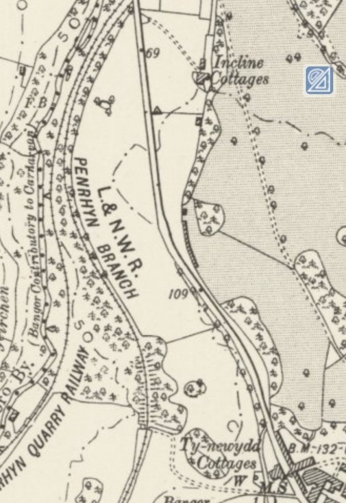
The Post-1879 Route of the Railway
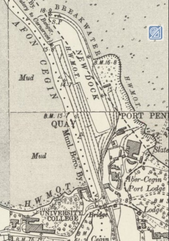
We start at the North end of the old railway at Porth Penrhyn. Porth Penrhyn) is a harbour located just east of Bangor in north Wales at the confluence of the River Cegin with the Menai Strait.
We follow the route on the Ordnance Survey 6″ Maps from around the turn of the 20th century as supplied by the National Library of Scotland (NLS). [10]


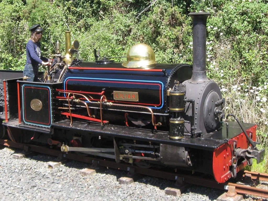
(ex-works May 1953, no. 383820). It is a 40HP, Ruston 0-4-0 with 3VRH diesel engine. The narrow-gauge steam locomotive is ‘Blanche’, © Eric Foulkes. [17]

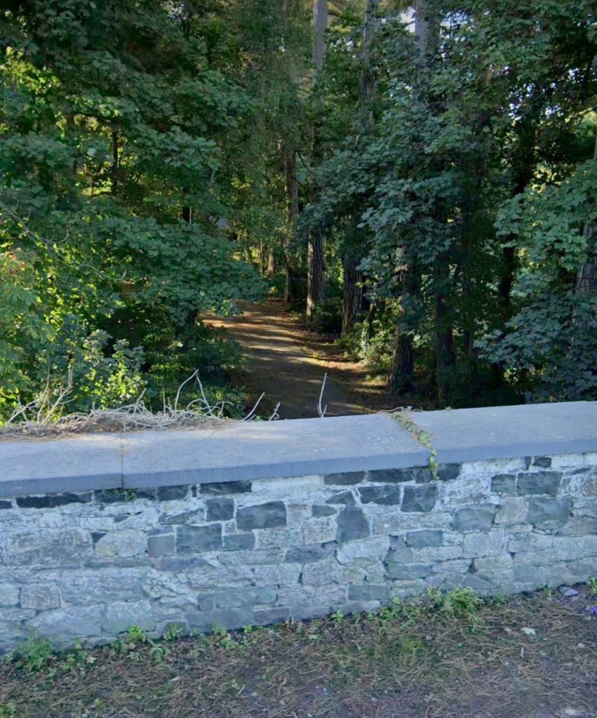

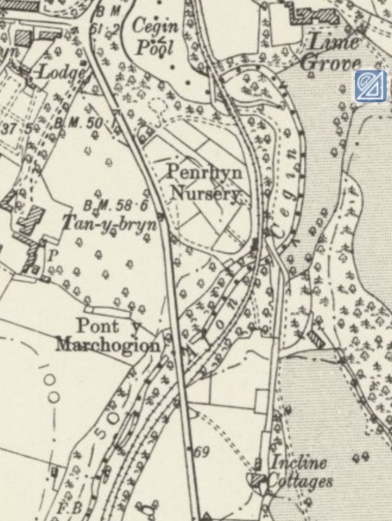


Before the future A5 was developed as a turnpike in 1820, the tramroad ran within the width of the old highway from this point for a few hundred yards. When the turnpike was created, the road level was lifted and the tramroad crossed beneath the renewed highway and ran along the Southwestern side. The sketch below shows this.


A. The old tramroad
Beyond this point, we first follow the line of the old Tramroad to Penrhyn Quarries. …..


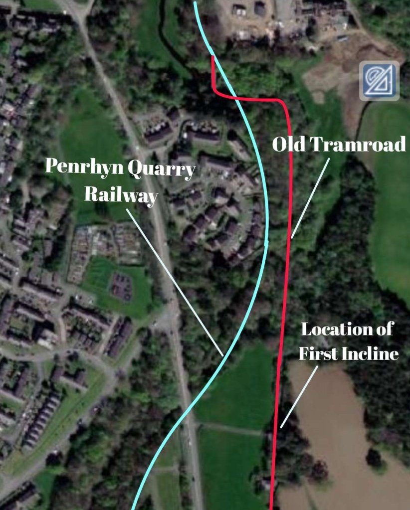
“The Ddinas Incline was one of three gravity-worked inclines on the original line of the Penrhyn Railway, built 1800-1801 to transport slate from the Penrhyn quarries to Port Penrhyn. … About half-way up the incline was an overbridge carrying a minor road, now widened and straightened at this point. To the north a cutting can still be seen, but the lower part of the incline has been destroyed by construction of a sewage works. To the south the line is visible as a terrace in the field. A ruined wall constructed of large roughly squared stone blocks near the top of the incline may be a surviving fragment of the winding house.” [33]
W J Crompton, RCAHMW, 5 November 2009.
From this point on, the old Tramroad and Penrhyn Quarry Railway followed approximately the same route. The second article about these lines will follow the Penrhyn Quarry Railway to this point at Tregarth.
References
- https://en.m.wikipedia.org/wiki/Penrhyn_Quarry_Railway, accessed on 27th December 2022.
- Dan Quine; The development of Port Penrhyn, Part One: 1760-1879; Archive. No. 110. Lightmoor Press, June 2021.
- James I.C. Boyd; Narrow Gauge Railways in North Caernarvonshire, Volume 2 The Penrhyn Quarry Railways; The Oakwood Press, Usk, 1985. (The British Narrow Gauge Railway No. 5.)
- Susan Turner; The Padarn and Penrhyn Railways; David & Charles; Newton Abbot, 1975.
- https://narrowgaugerailwaymuseum.org.uk/collections/industrial-railways/penrhyn-quarries, accessed on 27th December 2022.
- Thomas Middlemass; Encyclopaedia of Narrow Gauge Railways of Great Britain and Ireland; Patrick Stephens Ltd., Sparkford, Yeovil, 1991.
- Both these photographs can be found on the DeviantArt website: https://www.deviantart.com/rlkitterman, accessed on 27th December 2022.
- https://en.wikipedia.org/wiki/Penrhyn_Port_Class, accessed on 27th December 2022.
- https://en.wikipedia.org/wiki/Penrhyn_Main_Line_class, accessed on 27th December 2022.
- https://maps.nls.uk/os/6inch-england-and-wales/index.html, accessed on 27th December 2022.
- https://maps.nls.uk/geo/explore/#zoom=15.8&lat=53.23498&lon=-4.11253&layers=6&b=1, accessed on 27th December 2022.
- https://www.geograph.org.uk/photo/4180528, accessed on 27th December 2022.
- https://www.geograph.org.uk/photo/6960097, accessed on 27th December 2022.
- https://www.geograph.org.uk/photo/6554213, accessed on 27th December 2022.
- https://maps.nls.uk/geo/explore/#zoom=16.0&lat=53.22925&lon=-4.11044&layers=6&b=1, accessed on 28th December 2022
- https://m.facebook.com/groups/418992338717208/permalink/1139980376618397, accessed on 28th December 2022.
- https://m.facebook.com/groups/narrowgauge/permalink/6708832335795404, accessed on 28th December 2022.
- https://m.facebook.com/groups/narrowgauge/permalink/5131244703554183, accessed on 28th December 2022.
- https://maps.nls.uk/geo/explore/#zoom=16.0&lat=53.22458&lon=-4.11050&layers=6&b=1, accessed on 28th December 2022.
- https://www.geograph.org.uk/photo/4180575, accessed on 28th December 2022.
- https://m.facebook.com/groups/417502465072892/permalink/2232508116905642, please see the comments on this thread. Accessed on 28th December 2022.
- https://m.facebook.com/groups/417502465072892/permalink/529969163826221, accessed on 28th December 2022.
- https://m.facebook.com/groups/417502465072892/permalink/1512499952239799, accessed on 28th December 2022.
- https://maps.nls.uk/geo/explore/#zoom=16.0&lat=53.21987&lon=-4.10971&layers=6&b=1, accessed on 28th December 2022.
- https://maps.nls.uk/geo/explore/#zoom=16.0&lat=53.21884&lon=-4.10291&layers=6&b=1, accessed on 28th December 2022.
- https://maps.nls.uk/geo/explore/#zoom=16.0&lat=53.21309&lon=-4.10235&layers=6&b=1, accessed on 29th December 2022.
- https://www.railmaponline.com/UKIEMap.php, accessed on 29th December 2022.
- https://maps.nls.uk/geo/explore/#zoom=16.0&lat=53.20823&lon=-4.10044&layers=6&b=1, accessed on 29th December 2022.
- https://maps.nls.uk/geo/explore/#zoom=16.0&lat=53.20527&lon=-4.09580&layers=6&b=1, accessed on 29th December 2022.
- https://maps.nls.uk/geo/explore/#zoom=16.0&lat=53.20204&lon=-4.09043&layers=6&b=1, accessed on 29th December 2022.
- https://maps.nls.uk/geo/explore/#zoom=16.4&lat=53.19818&lon=-4.08442&layers=6&b=1, accessed on 29th December 2022.
- https://maps.nls.uk/geo/explore/#zoom=15.9&lat=53.19386&lon=-4.08259&layers=6&b=1, accessed on 29th December 2022.
- W J Crompton, RCAHMW, 5 November 2009, accessed via: https://coflein.gov.uk/en/site/409718, accessed on 31st December 2022.
- https://en.m.wikipedia.org/wiki/De_Winton, accessed on 3rd January 2023.
- Barrie K Lill; Richard Pennant, Samuel Worthington and the mill at Penlan: a history of the Penrhyn Mills on the Lower Ogwen; Bangor University, 2019, accessed via https://research.bangor.ac.uk/portal/files/22801787/2019_Lill_B_PhD.pdf, accessed on 5th January 2023.
- J.I.C. Boyd; Narrow Gauge Railways in North Caernarvonshire, Vol.II, The Penrhyn Quarry Railways; The Oakwood Press, Usk, 1985.
- Personal correspondence dated 20th November 2017 alluded to by Barrie Lill in reference [35]
- Permission sought to share some further photographs of Porth Penrhyn (https://www.ebay.co.uk/itm/293353217633?mkcid=16&mkevt=1&mkrid=711-127632-2357-0&ssspo=vFhrxofnRnO&sssrc=2349624&ssuid=afQhrar7TGK&var=592202447151&widget_ver=artemis&media=CO)

Very interesting article, thanks. Boyd claims that the original route of the tramway was diverted to the other side of the A5, is this correct.
It might be John. Have you got the reference/quote from Boyd?
Yes page 22 in his book Penrhyn Quarry Railway he states that ‘the railroad was re aligned and a tunnel made under the new road’ following construction of the Shrewsbury – Holyhead road. He infers that the original course was to the north of what became the road. Beyond that I have no other reference.
The newer alignment might be the route to the South of the A5 that I note in the text but I cannot be sure.
3 of the engines supplied by de winton where had horizontal boilers much larger than the vertical boilers the first George England sized to small, next larger 9*12 engines still to small Charles replaced the first de Winton all three worked in the quarries after 1893 until the 1910’s. Ref my book on de Wintons, pictures of small and large de Wintons exist, first was a saddle tank the second and third were side tanks
Thank you David. What is you book called?
De winton of caernarfon rcl publications 2011 we have a couple of copies I think they are sold out elsewhere. The book gives drawings photos and what is know of the spec from letters.
What price are they?
Fascinating to see the OS map, satellite image and text all linked together. How can I print this, for my own use only?
Hi Sydney, thank you. WordPress does not facilitate printing and unless I pay a much higher subscription does not permit me to create a good quality .pdf file. I have no objection to you having a copy, in fact I am delighted that you would like one. At the moment, the best I can suggest is that you take screen dumps on a desktop computer and then put the images into a MSWord file. Google Lens might permit something similar.
Best wishes for 2023.
Roger
Thanks, Roger. I will try that. Alternatively, I will save the original communication. I have many happy memories of the Welsh slate quarries, not least a ride from Bethesda to Port on the afternoon train.
Sydney
Have you come across Barrie Lill’s research on Penlan Mill? He found that the tramway first ran from the port to the mill before being extended to the quarry.
Sorry David, I have not. Could you point me in the right direction.?
https://research.bangor.ac.uk/portal/en/theses/richard-pennant-samuel-worthington-and-the-mill-at-penlan(828fc6f7-ba4e-4da5-95a8-edbe30401ec2).html
Thank you. I have adjusted the text of my article to include reference to Lill’s research and added a few references.
Pingback: The Penrhyn Quarry Railway – Part 2 | Roger Farnworth
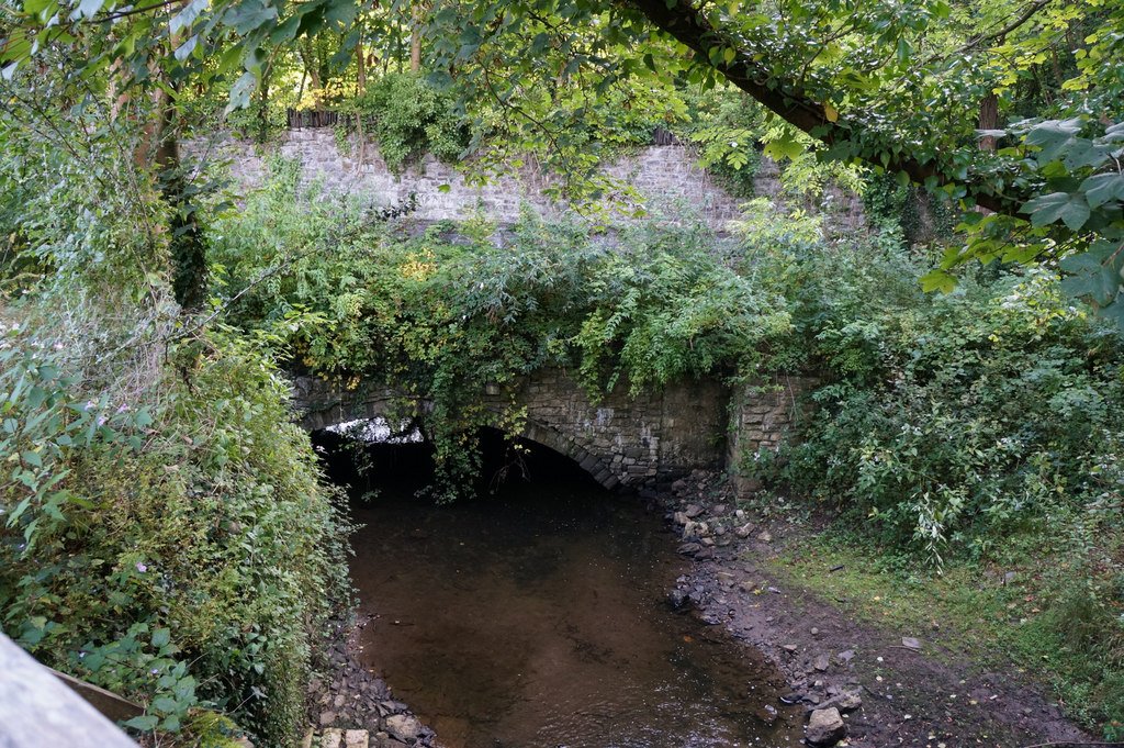
A great article. Thank you. Having explored the lower route today, can you explain the difference in height levels over the Afon Cegin bridge at the base of the Port incline?
The original horse drawn tramway appears to be level with the original arch river bridge, two to three metres lower than the later steam hauled line. From appearance, it looks as if when the new line was built, the bottom of the incline horse drawn route has been raised to match it, with a new embankment and walls built over the top of the river bridge. This suggests to me that the incline was still required and in operation for the Penhryn Mill when the new route was opened?
Also, the point where the bridge meets the new steam hauled / standard gauge route is also marked by an archway inset into the opposite wall of the Glan Traeth housing estate. It doesn’t look like a structural feature, as the rest of the wall is flat fronted all the way along. Did the incline route carry on straight over on a diamond crossing with this area used as some form of fiddle yard / engineering works?
Thank you for the comments. I might not be understanding fully what you are saying, but it seems as though the tramroad was in use as you suggest for some time to serve the Penrhyn Mill. Do you have any pictures taken today which could illustrate what you are saying?
Unfortunately, the only picture I took earlier was of the bridge itself. I’ve attached it here, but don’t know if it will work in the comments, so have uploaded it here: https://imgur.com/gallery/n36t7aj
You can clearly see the bridge arch is very wide – you mentioned it was an old roadway? The embankment on top of it is only about two-thirds of the width on the south / upstream side. Downstream, the bridge sides extend all the way up flush with the original arch. It also has very high parapets / walls on either side for some reason. When walking along the current cycleway, there’s a 5ft wall stopping easy access from the cycleway. Difficult to tell if the rails were high to cross over the steam lines on a bridge, or met on the level. I’ll have to go for another walk tomorrow!
Best Wishes, Mat.
Hi again Mat, I have taken a photo of James Boyd’s sketch on page 11 of his book on the line. Just working out how best to send it to you.
My email address is rogerfarnworth@aol.com, if you want, please drop me an email and I will send you the page from Boyd’s book in a reply.
Best wishes
Roger
Thanks Matt. It is a good photo of the bridge. Yes I did mention and old road. I will check to see where I picked that up from.
Further inspection of the site today (and a chat with a local chap walking his dog), have revealed more about the bridge.
Walking over the raised embankment on top of the bridge, it is now clear that this is a later trackway built on top at the higher level after the incline closed. It runs parallel to the East of the incline plane. The arch in the wall opposite the bridge would have led through to Penhryn Castle’s market garden. Therefore, it looks as if there was a level crossing here for horse and cart(?) access to take produce from the nursery gardens up to the Castle.
I’ve done a rough timelapse walk from the viaduct up to the bridge, and you can see the arch and track at the end of the clip:
Mat, that is fantastic – really helpful, would you like me to add anything to the text of the article, perhaps to include the link to the timelapse video?
Roger, you’re welcome to use it. Also, they’re a bit rough and ready, but I’ve stuck the pictures I took at the weekend online, with brief descriptions of what they’re showing. I didn’t get any photo showing the top half of the incline, as it’s someone’s private driveway, and gave up following the standard gauge line all the way through the industrial estate as it got a bit awkward due to rubbish, mud and growth.https://imgur.com/gallery/F1hsJ8B