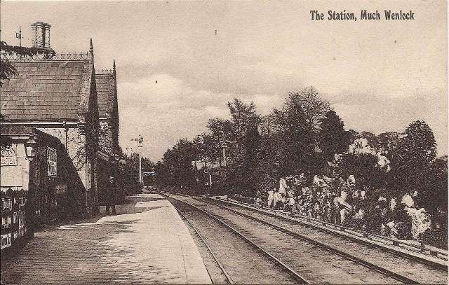
The featured image shows Presthope Station with the 18.00 hrs Craven Arms – Much Wenlock – Wellington train is leaving on 21st April 1951, heading for Much Wenlock. [30]
This article follows on from four other articles which covered the Wellington to Severn Junction Railway and this line from Buildwas to Much Wenlock. The first three articles can be found on these links:https://rogerfarnworth.com/2022/07/07/the-railways-of-telford-the-wellington-to-severn-junction-railway-wsjr-part-1-wellington-to-horsehay https://rogerfarnworth.com/2022/07/12/the-railways-of-telford-the-wellington-to-severn-junction-railway-wsjr-part-2-horsehay-to-lightmoor-junction https://rogerfarnworth.com/2022/07/18/the-railways-of-telford-the-wellington-to-severn-junction-railway-wsjr-part-3-lightmoor-junction-to-buildwas
The most recent article covers this line between Buildwas and Much Wenlock and can be found here:
The Railways of East Shropshire (and Telford) – the Much Wenlock and Severn Junction Railway, Buildwas to Much Wenlock. Much Wenlock to Presthope and on to Craven Arms
From the commencement of the building of the line between Buildwas and Much Wenlock, the directors hoped that the line could be extended to Craven Arms via Presthope on Wenlock Edge (linking with the limestone quarries/works at that location).
The directors of the Wellington & Severn Junction Railway were, however, fully occupied with the line from Wellington to Buildwas. Another company was set up to build the ‘Wenlock & Craven Arms and Coalbrookdale Extension Railway ‘. The bill went through the parliamentary process unopposed and authorised the ‘Wenlock Railway Company ‘ to construct the line. Work started on 23rd October 1861.
By 5th December 1864, the line was open from Much Wenlock to Presthope. At this time, because it was a freight-only line, the Board of Trade saw no need for an inspection of the line. It had already been agreed at a meeting held on 4th December 1863 not to proceed with the line from Presthope to Craven Arms for the time being. It was to be three years after the line reached Presthope before the connection to the Shrewsbury & Hereford Railway close to Craven Arms was completed. It was finally opened on 16th December 1867.
Much Wenlock to Presthope
This article focusses on the length of the line which was completed in December 1864 – Much Wenlock to Presthope. Another article will follow the line to the West of Presthope.
We start at Much Wenlock Railway Station.
The forecourt of Much Wenlock station in the early 1960s. The building was designed by Joseph Fogerty © R.S. Carpenter. [1: p100] The Wenlock Branch ran across the Northwest side of the town. The railway station was due North of the town centre and was accessed from a loop off Sheinton Road. Station Road leading up to the Station from close to the railway bridge. [4] The 25″ Ordnance Survey of 1901 shows Much Wenlock Station with its platform on the Northwest side of the running line and a passing-loop to the Southeast. Partially off the left of the map extract is the town brewery. [5] Much Wenlock Railway Station had a single platform adjacent to the main running line. A passing loop was provided opposing the platform, and beyond it there was a rockery garden, “large limestone boulders [were] interspersed with shrubs and alpine plants flanked by a row of rhododendron bushes . In the centre of the rockery was a fountain. ” [1: p97]
Much Wenlock Railway Station in the very early 20th century. The passing-loop and the adjacent rockery garden are on the right of the image. The photograph looks Northeast through the station. [7] The photographer is standing on the running line a few steps further to the Southwest. This photo was taken on 12th July 1969 by David Hillas and is used here under a Creative Commons Licence (CC BY-SA 2.0 DEED). [8] The length of the station site as shown on Railmaponline.com. The running line is shown in green with a single line indicating the location of the Goods Yard. [12] This is a first extract, in this article, from the pre-contract plans of the Much Wenlock line which are held in the Shropshire Archives in Shrewsbury. It shows the full length of the station facilities (passenger and goods) at Much Wenlock. It shows approximately the same length as the RailMapOnline image above. The Station building was on the West side of the line and North of the bridge which carried the line over what became the A4169. The goods yard was South of the bridge on the East side of the line. … As we have noted in the article about the line between Buildwas and Much Wenlock, these precontract plans were orientated in respect to the North point so as to get the greatest possible length of the proposed railway onto each sheet,, © Shropshire Archives Ref. No. 6008/26 copyright reserved, used by kind permission. [9][My photograph of the plan, 5th August 2022] Trains leaving for Craven Arms crossed Sheinton Road/Street Bridge and passed the goods shed and yard on the left and then the engine shed. When the line terminated at Much Wenlock, the goods facilities used until the final closure of the line were the temporary railway station.
A view Northwest along Sheinton Street taken outside number 19 Sheinton St. It is included here for the view of the railway bridge over the road and was taken in the first half of the 1960s. This image was shared on the Much Wenlock Memories Facebook Group by Lynne Steele on 10th April 2021. [10] A view Southeast along Sheinton Street showing one of the carnival walks in Much Wenlock probably in the mid-60s. It is included here for the view of the railway bridge which span the road. This image was shared on the Much Wenlock Memories Facebook Group by Colin Onions on 2nd February 2015. [11] Looking Northeast along the line of the old railway towards the passenger Station from the approximate location of the second abutment of the railway bridge. Just the one abutment remains, the other having been removed to facilitate a road realignment. The road from Buildwas (Sheinton Street) becomes New Road at this point with Sheinton Street heading away to the right of the image. [Google Streetview, August 2023] This is the view when the camera is turned through 180°. The approximate line of the old railway is marked, in this case, by the red line. New Road and the route of the railway diverged and provided space for what became the Goods Yard and for a coal depot which, in the early 21st century is occupied by a builders merchant (Travis Perkins). [Google Streetview, August 2023] Looking Southwest along Southfield Road. The hedge line on the left of this image is approximately on the line of the old railway. [Google Streetview, 2009] Much Wenlock Goods Yard. Centre-left are the cattle pens and grain store. The grain store is attached to the good shed. On the right is the engine shed with the water tank. The water tank was fed by a reservoir further Southwest along the line – about halfway to the next halt, Westwood Halt, © Shropshire Museum Service [1: p101] The goods yard, viewed from the Southwest the line in the foreground is the main running line which claims along the flank of Wenlock Edge. The good yard was, for a short time, the terminus of the line after the partial opening on 1st February 1862 © Pat Garland. [1: p101] Trains began the climb towards Wenlock Edge. The pictures above show the climb had already begun alongside the goods yard. Neither the goods shed nor the engine shed remain in the 21st century.
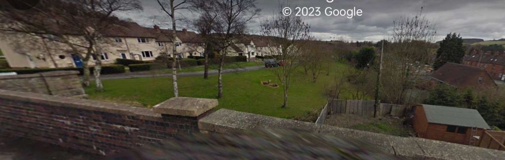
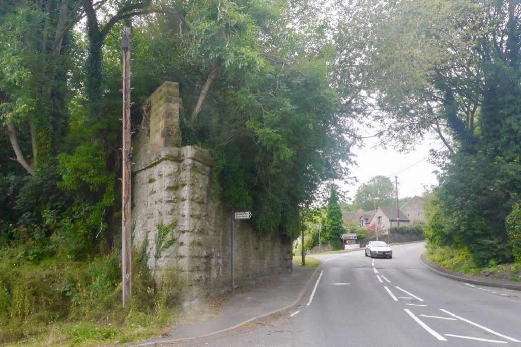
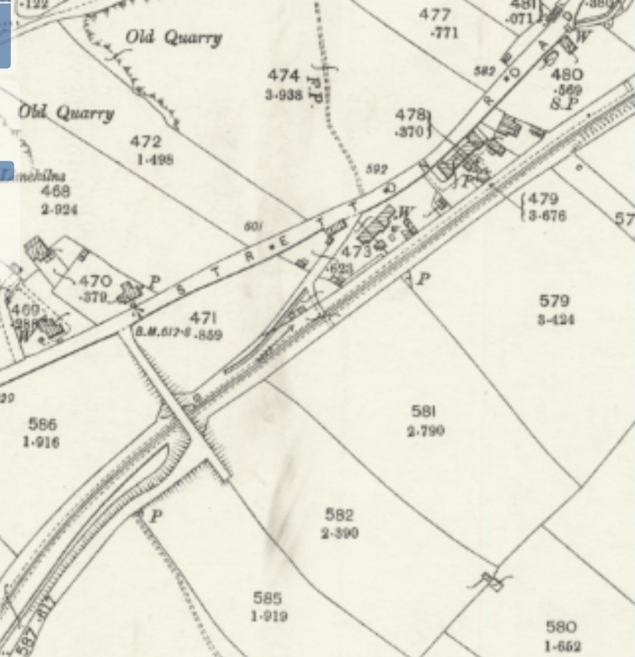
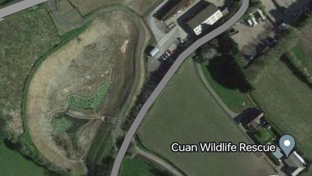
This aerial view is taken looking North across Much Wenlock (EAW046197 © Heritage England). The station goods yard is prominent approximately at the centre of the image, with Sheinton Street and the railway bridge separating the yard from the passenger facilities in the top-right of the image, and the bridge carrying Bridge Road over the line at the bottom-left. [3] This extract from an aerial image (EAW046196 © Heritage England) shows the full length of the station facilities at Much Wenlock. The passenger Station building is visible top-right, the goods yard and engine stabling facilities, bottom-left. Between the two Sheinton Street passed under the railway. [2] New Road ran along the Southeast side of the Goods Yard. The Goods Shed and the Engine Shared appear on this additional extract from the 25″ Ordnance Survey of 1901. A coal depot sat between the road and the sidings in the yard. The road bridge is at the top-right of the map extract. Bottom-left as the running line leaves the map extract it passes under Bridge Road. The bridge here was simply-supported cast iron beams on masonry abutments. [6] Another extract from the same aerial image centres on the goods yard with the running line to the left and passing under the cast iron bridge carrying Bridge Road. New Road runs down the right side of the picture. [2] A closer view of the cast iron bridge carrying Bridge Road over the railway. This is an enlargement from the same aerial image. [2] Looking Southwest from Southfield Road. The main structure of the bridge is still evident in the early 21st century. [Google Streetview, 2009] Looking Southeast at the other elevation of the cast-iron bridge. The partial infill is much closer to the soffit on this side of the bridge. [Google Streetview, 2009] Looking North over the bridge parapet from Bridge Road. The old railway ran parallel to Southfield Road in the grass area at the centre of the image. [Google Streetview, 2009] Looking West over the bridge parapet from Bridge Road. The old railway ran parallel to Southfield Road in the grass area at the centre of the image. [Google Streetview, 2009] Southwest of Bridge Road, Southfield Road ran parallel to the old railway as it climbed along the Northwest side of the town. Victoria Road can be seen at the bottom of this image. [2] The line continued in a southwesterly direction. Southfield Road ran alongside it. Victoria Road can be seen at the bottom of this image. It passed under the railway a short distance beyond the edge of the aerial image which is also the left edge of this extract. [2] The next length of the railway appears on this extract from the 25″Ordnance Survey of 1901. Bridge Road bridge is top-right and the road to Shrewsbury runs East-West across the bottom half of the image. In 1901, this was known as ‘The Causeway’. It became the A458, Victoria Road. [14] Approximately the same length of the railway as shown in the map extract above, but now on the satellite imagery from ralmaponline.com. The primrose yellow line shows the route of the A458, Victoria Road. [12] Looking back Northeast towards Much Wenlock Railway Station from High Causeway. Southfield Road is on the left. The housing estate has been built over the Goods Yard. [Google Streetview, 2009] Looking Southwest along the line of the old railway. Southfield Road is on the right. The railway This and the next three OS map extracts cover the first part of the climb out of Much Wenlock the bridge over the A458 is at the top-right of this map extract. [15] The bridge over what is now the A458 in the midst of its demolition at the end of the 1960s. This image looks Northeast along the railway formation towards Much Wenlock Station and Goods Yard. It was shared on the Much Wenlock History Facebook Group by Linda West on 2nd April 2020. [18] The remaining abutment of the bridge which carried the Wenlock Branch over Victoria Road (A458), © Richard Webb and licenced for use under a Creative Commons Licence (CC BY-SA 2.0 DEED). [20] These two images are extracts from the pre-contract drawings of the Wenlock Branch. The girder branch which scanned The road at this location was almost exactly 4 miles from Buildwas Junction and fell, in these drawings at the edges of two drawings. Both are reproduced here because they have something to contribute to local information. Perhaps of greatest significance for the railway was the fact that the bridge was constructed allowing for the possibility of providing an additional line, if traffic volumes made it worthwhile. These pre-contract plans were orientated in respect to the North point so as to get the greatest possible length of the proposed railway onto each sheet, © Shropshire Archives Ref. No. 6008/26 copyright reserved, used by kind permission. [9][My photograph of the plan, 5th August 2022] The next length of the line continued in a Southwesterly direction. After passing under an accommodation bridge, it began to turn to the South. [13] The reservoir which appears on this OS map extract on the East side of the line was used to provide water for the column at Much Wenlock Station. [1: p97] [16] The reservoir which supplied the water column at Much Wenlock Station was around half a mile beyond the bridge over the A458. These pre-contract plans were orientated in respect to the North point so as to get the greatest possible length of the proposed railway onto each sheet, © Shropshire Archives Ref. No. 6008/26 copyright reserved, used by kind permission. [9][My photograph of the plan, 5th August 2022] The reservoir as it appears in the 21st century. It has been extended and has varying levels over time suggesting that it may be used as a balancing pond to moderate the flow on the stream which follows the old railway line and which appears to now follow the old railways route in an improved channel to the Southwest of the reservoir. The track shown in this extract from Google Maps continues a short distance to the South before crossing both the stream and the old railway route.A footpath continues alongside the old line to the East. [Google Maps, 13th January 2024] Curving round again towards the Southwest, the line passed Grange Cottages. [17] This railmaponline.com satellite image covers the same length of line as the last four OS Map extracts. [12] The first road overbridge to the West of Much Wenlock. This view looks Southwest along the line of the old railway. The bridge carries a track which leaves the B4371, Stretton Road in a southerly direction and provides access in the 21st century to the Cuan Wildlife Centre. [My photograph, 12th January 2024] The view Northeast from the overbridge. The old railway route is now followed by a line of conifers on its North side. [My photograph, 12th January 2024] The view Southwest over the parapet of the same bridge. The warehouse is built over the old railway line. [My photograph, 12th January 2024] Looking Northeast again for a point beyond the warehouse in the last picture. The warehouse sits over the line of the old railway which continued Southwest to the left of the green palisade fencing on the left side of this image. The track in the centre of the image runs parallel to and to the South of the line of the railway. [My photograph, 12th January 2024] Looking back Northeast along the route of the old railway. The gate towards the back of this photo straddles the centre-line. The gardens associated with Grange Cottages now extend across the line of the railway. [My photograph, 12th January 2024] Looking Southwest along the line of the old railway from the fence line of Grange Cottages garden. The gate across the line of the old railway indicates that the next length is also in private hands. A public footpath runs to the left of the tree line This next extract from the OS mapping of 1901 takes the line as far as the location of Westwood Halt which was at the location marked by the blue flag above. [21] A closer view of the location of the Halt in 1925. The 25″ OS mapping indicates that the Halt was not built by 1925. [22] The length of the old railway between Grange Cottages and Westwood Halt as shown on the satellite imagery from railmaponline.com. [12] That length is in private hands with a significant length in use as a paddock for horses and a small holding.
Westwood Halt in around 1960 – seen from the East. The single platform sat on the North side of the line immediately to the East of Westwood Crossing. It was not until 7th December 1935 that the Halt opened. It closed to passenger traffic on 31st December 1951. This picture was shared on the Much Wenlock Memories Facebook Group by Judith Goodman on 8th December 2020. The photographer is not known and the image is used under a Creative Commons Licence (CC BY-SA 4.0). [19] Google Maps image of the site of Westwood Halt. [Google Maps, 12th January 2024] Westwood Crossing seen from the North. The red line marks the approximate centre-line of the old railway. The Halt would have been off to the left of this image. [Google Streetview, 2009] Looking Northwest from Westwood Crossing towards the B4371. [My photograph, 12th January 2024] Looking Southeast from the location of Westwood Crossing. It is not possible to follow the route of the old railway to the West of this location as it is in private hands. To continue following the route requires a diversion along the footpath ahead, across one field to join another track and then heading back Northwest towards the olod line. [My photograph, 12th January 2024] The line leaving Westwood Crossing and heading towards Presthope. [My photograph, 12th January 2024] Westwood Crossing to the next overbridge, as shown on the 25″ Ordnance Survey of 1901. [22] Within a couple of hundred yards, trains passed Westwood Sidings. The sidings served Westwood Quarry. There were ground frames controlling access at each end of the siding. [23] When the Wenlock Branch opened “limestone was being extracted [at Westwood Quarry] for use in the Madeley Wood Company’s furnaces. Horse-drawn tramways ran from the quarry on to a loading ramp above the sidings .” [1: p97]
The immediate vicinity of the line close to Westwood Quarry. A tramway track ran from the quarry to the old railway. A sharp 90° turn took horse-drawn trams alongside the old railway to a wharf/loading ramp alongside the siding, © Shropshire Archives Ref. No. 6008/26 copyright reserved, used by kind permission. [9][My photograph of the plan, 5th August 2022] Westwood Sidings as they appear on the pre-contract drawings for the construction of the Wenlock Branch, the tramway serving the Quarry ran alongside the Wenlock Branch from East to West, © Shropshire Archives Ref. No. 6008/26 copyright reserved, used by kind permission. [9][My photograph of the plan, 5th August 2022] This extract from the 1901 25″ Ordnance Survey shows the length of the old railway immediately to the West of Westwood Sidings. [25] And a little further to the Southwest. [26] The 25″Ordnance Survey of 1901 again. Close to Lea Farm the B4371 and the Wenlock Branch run close to each other. [27] This extract from the pre-contract drawings covers the same length of the Wenlock Branch as the three OS map extracts above, © Shropshire Archives Ref. No. 6008/26 copyright reserved, used by kind permission. [9][My photograph of the plan, 5th August 2022] The immediate vicinity of the old Westwood Sidings as shown on modern Ordnance Survey mapping (OS Explorer No. 217). The route of the old railway can easily be picked out entering top-right and running across the North side of Lower Farm, a public footpath follows the line as far as the location of Westwood Crossing. The route of the old line is then crossed by an unmetalled track (which, on the North side of the line, was once a horse-drawn tramway) before it encounters the bridge illustrated below which, in the 21st century, is crossed by a metalled track. Westwood Sidings sat between these two tracks. Continuing Southwest, the route of the old line encounters quarry workings which postdated the closure of the railway and which in the 21st century are now flooded. [24] The length of the old line from Westwood Crossing to the Eastern edge of the flooded workings of Lea Quarry which straddle the old rail route. [12] Looking back towards Westwood Crossing from the first overbridge to the West. [My photograph 12th January 2024] The bridge viewed from the top of the cutting to the West of the bridge. [My photograph, 12th January 2024] The view from the Southeast along the track over the bridge. Westwood Sidings were along the old railway to the left. A tramroad climbed the track in front of the camera towards Wenlock Edge and the B4371. Thetramway served Westwood Quarries which were between the railway and the B4371. [My photograph, 12th January 2024] The old railway ran ahead towards Presthope in cutting towards the next overbridge. [My photograph, 12th January 2023] The next accommodation bridge which spanned the line was just a little further to the West, beyond of the Westwood Sidings. This photograph looks South along the road over the bridge. [Google Streetview, August 2021] The same bridge which This photograph looks South along the road over the bridge. [Google Streetview, August 2021] Looking back towards Westwood Halt from the next overbridge. Heavy winter rain means that the cutting floor is flooded. Westwood Sidings were between the last overbridge and this one. [My photograph, 12th January 2024] Each of the bridges on the old line are numbered. It is probably sometime since the stenciled numbers were renewed. Is this Bridge No. 16? The view to the Southwest from the bridge. A small caravan site occupies the formation here. Immediately beyond the conifers ahead are the flooded workings of Lea Quarry. [My photograph, 12th January 2024] Lea Quarry was only a short distance from the location of Westwood Quarry. Lea Quarry’s flooded workings appear in full on this extract from the railmaponline.com satellite imagery. The flooded workings to the North of the B4371 sit where once Lea Farm would have been found. It is not obvious when travelling along the road that it is effect on a causeway between two lakes! Edge Renewables was founded in 2011 and is active in the part of Lea Quarry to the North side of the road.[12] Another extract from the 25″ Ordnance Survey of 1901. This extract focuses on Presthope Station which sat just to the South of the B4371 accessed by a dedicated approach road. [28] This next extract from the railmaponline.com satellite imagery shows Presthope Grange Campsite and Residential Park sitting over the route of the old Wenlock Branch on the site of Presthope Station. The branch from Presthope Station into what were Presthope quarries is illustrated leaving the main running line as it continues to climb toward the short tunnel close to the top of Wenlock Edge. [12] The 18.00 hrs Craven Arms – Much Wenlock – Wellington train leaving Presthope Station on 21st April 1951, heading for Much Wenlock. This image was shared on the Telford memories Facebook Group by Metsa Vaim EdOrg on 8th October 2019. [30] Presthope Station after the removal of the passenger facilities. This photograph was taken by J. Langford in April 1962, the signal box and presumably the station master’s house remain. This image was shared on the Much Wenlock Memories Facebook Group by Judith Goodman on 9th February 2023. [31] A view North across Presthope Grange Residential Park which sits on the site of Presthope Railway Station. [32] References
Ken Jones; The Wenlock Branch ; The Oakwood Press, Usk, Monmouthshire, 1998.
https://www.britainfromabove.org.uk/image/EAW046196 , accessed on 1st November 2023https://www.britainfromabove.org.uk/image/EAW046197 , accessed on 1st November 2023.https://www.british-history.ac.uk/vch/salop/vol10/pp399-447 , accessed on 25th December 2023.https://maps.nls.uk/geo/explore/#zoom=17.5&lat=52.59954&lon=-2.55716&layers=168&b=1 , accessed on 25th December 2023.https://maps.nls.uk/geo/explore/#zoom=16.9&lat=52.59775&lon=-2.56049&layers=168&b=1 , accessed on 25th December 2023.https://en.m.wikipedia.org/wiki/Much_Wenlock_railway_station , accessed on 25th December 2023.https://www.geograph.org.uk/photo/2268995 , accessed on 25th December 2023.The photographs of the pre-contract drawings for the line were taken by myself and show extracts from the construction plans held in the Shropshire Archive. There is a standard charge of £10 per visit for taking photographs of their records.
https://www.facebook.com/photo?fbid=871714362892537&set=pcb.1583276891885898 , accessed on 13th October 2023.https://en.m.wikipedia.org/wiki/File:Much_Wenlock_railway_station.jpg , accessed on 14th October 2023.https://railmaponline.com/UKIEMap.php , 14th October 2023.https://maps.nls.uk/geo/explore/#zoom=16.5&lat=52.59360&lon=-2.57210&layers=168&b=1 , accessed on 27th December 2023.https://maps.nls.uk/geo/explore/#zoom=16.5&lat=52.59611&lon=-2.56444&layers=168&b=1 , accessed on 27th December 2023.https://maps.nls.uk/geo/explore/#zoom=16.5&lat=52.59513&lon=-2.56857&layers=168&b=1 , accessed on 27th December 2023.https://maps.nls.uk/geo/explore/#zoom=16.5&lat=52.59146&lon=-2.57500&layers=168&b=1 , accessed on 27th December 2023.https://maps.nls.uk/geo/explore/#zoom=16.5&lat=52.58847&lon=-2.57795&layers=168&b=1 , accessed on 27th December 2023.https://www.facebook.com/groups/1532191000361509/permalink/2624088597838405/?app=fbl , accessed on 27th December 2023.https://m.facebook.com/groups/1470137459866509/permalink/3158174324396139 , accessed on 27th December 2023; and https://commons.m.wikimedia.org/wiki/File:Westwood_halt.jpg , accessed on 28th December 2023.https://www.geograph.org.uk/photo/6220870 , accessed on 27th December 2023.https://maps.nls.uk/geo/explore/#zoom=15.5&lat=52.58777&lon=-2.58269&layers=168&b=1&marker=52.58420,-2.58663 , accessed on 28th December 2023.https://maps.nls.uk/view/121151366 , accessed on 28th December 2023.https://maps.nls.uk/geo/explore/#zoom=16.2&lat=52.58321&lon=-2.59431&layers=168&b=1 , accessed on 28th December 2023.Ordnance Survey Explorer Map No. 217.
https://maps.nls.uk/geo/explore/#zoom=16.4&lat=52.58031&lon=-2.59601&layers=168&b=1 , accessed on 30th December 2023.https://maps.nls.uk/geo/explore/#zoom=16.4&lat=52.57873&lon=-2.60143&layers=168&b=1 , accessed on 30th December 2023.https://maps.nls.uk/geo/explore/#zoom=16.4&lat=52.57772&lon=-2.60633&layers=168&b=1 , accessed on 30th December 2023.https://maps.nls.uk/geo/explore/#zoom=15.9&lat=52.57594&lon=-2.61148&layers=168&b=1 , accessed on 2nd January 2024.https://maps.nls.uk/geo/explore/#zoom=15.9&lat=52.57503&lon=-2.61667&layers=168&b=1 , accessed on 2nd January 2024.https://scontent.fbhx4-2.fna.fbcdn.net/v/t1.6435-9/72309512_205899980403678_7031472482779398144_n.jpg?_nc_cat=106&ccb=1-7&_nc_sid=3ba11c&_nc_ohc=emwNw6dTtOEAX98lstF&_nc_oc=AQltLJN6CydIE1iwVeZIhsh7FebhgpjYSXj4bSzrDzZFN1GkxA9MgvTWDIpb8u77FAIVOOqJDbVO3NSZWciOhtxl&_nc_ht=scontent.fbhx4-2.fna&oh=00_AfBnQj18_fNuJPC8cc8S55O0uoHKcfFj4B4xt0r1e4TwTA&oe=65BB609F , accessed on 2nd January 2024.https://www.facebook.com/photo/?fbid=10219517828553747&set=a.10201009954868472 , accessed on 13th January 2024.https://fb.watch/pjIctGeJKI/ , accessed on 2nd January 2024.


Roger,
This is amazing, thank you sir much, an area we know and love. I have organised an arts tour of Wenlock abbey in April, the home of Gabrielle Drake, so all interesting information.
Do you have the equivalent information about Buildwas station, the junction of the Wellington and Craven arms, and the Severn Valley railway to Shrewsbury? I would really appreciate that if you have as it will assist the project I mentioned to you.
Thank you,
Michael
>
Yes Michael, you are welcome to have a look on my blog (rogerfarnworth.com) but if you look at the top of the article you have just read there are links to my other articles on the line from Wellington to Craven Arms.
Best wishes
Roger