
Someone who read my post on the Bicester Military Railway challenged me to look at the railway(s) which used to serve Nesscliffe Training Area. This first post traces the life of the old branch-line which served the area and was taken over by the military. A further post should follow which looks at the military sites themselves. Apologies for the length of the title!
As I have undertaken this research I have become increasingly aware of the complex railway and tramway arrangements in the area to the West of Llanymynech which is probably best left to another occasion rather than seeking to cover it as part of this post.
The Shropshire and Montgomeryshire Light Railway
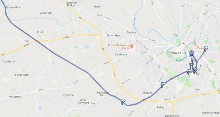
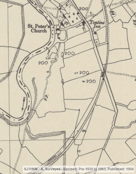
The old Shropshire and Montgomeryshire Light Railway (S&MLR) was commandeered by the military to allow the creation of a major armaments storage facility at Nesscliffe. The main length of the old railway is highlighted in the overlay on Google Maps below. [1]
The S&MLR was often referred to at ‘The Potts Line’. It ran from Shrewsbury, England to Llanymynech, Wales, with a branch to Criggion. [2]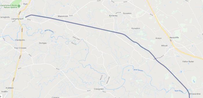
 The S&MLR opened in 1911. The company ran the reconstructed Potteries, Shrewsbury and North Wales Railway which continued to be owned by the Shropshire Railways Company, and was one of the Colonel Stephens Railways. It lost its passenger services in 1933, although some limited bank holiday services for tourists continued until 1937. [2]
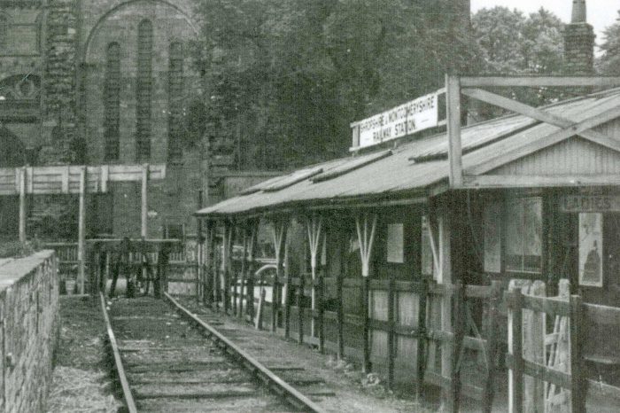
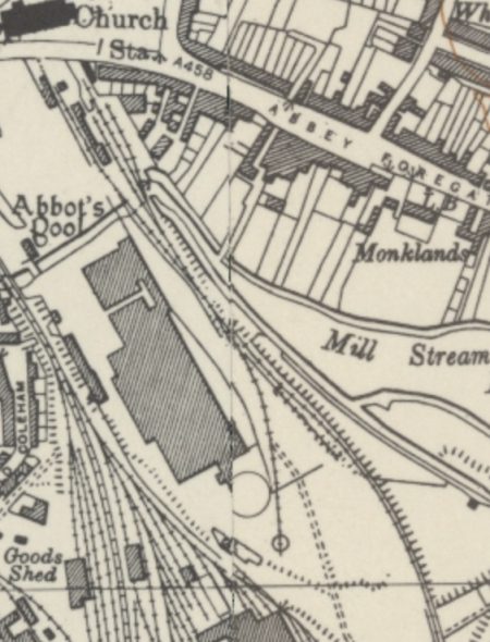
The terminus of the line was at Shrewsbury Abbey station not at Shrewsbury railway station. This was because the joint operators, Great Western Railway (GWR) and the London and North Western Railway (LNWR) refused to let the smaller company have access to mainline services. After the railway closed Shrewsbury Abbey was retained as an oil depot siding connected to a stub of the Severn Valley branch. The site finally closed in 1988. A new road in the area has been named “Old Potts Way” as a reminder of what was known as ‘The Potts Railway’. [2]
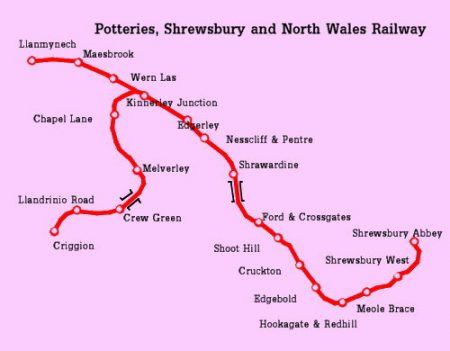
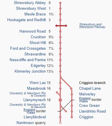 A number of the stations shown in the adjacent diagram were added after the closure of the original Potteries, Shrewsbury & North Wales Railway. [2]
The Potteries, Shrewsbury & North Wales Railway
The original Potteries, Shrewsbury & North Wales Railway Company opened in 1866. Wikipedia says that it obtained “notoriety as the most expensive non-metropolitan railway then built, but was never constructed between Shrewsbury and the Potteries. The line rapidly became very run down as a result of low revenues and poor maintainace and was closed for safety reasons in June 1880, becoming one of the few railways to close in Victorian times. Attempts to re-open the line were made in the late 1880s and the 1890s by the Shropshire Railways who took over the property but these failed. After years of lying derelict, it re-opened as the Shropshire & Mongomery Light Railway in 1911.” [3]
John Speller confirms this but widens the information on the line, placing in the context of a wider network: “The Potteries, Shrewsbury and North Wales Railway (PS&NWR) or “Potts” for short was an over-ambitious plan to build a line connecting the quarries at Nantmawr and Criggion via Shrewsbury to Market Drayton and then via the North Staffordshire Railway to Stoke-on-Trent and the Potteries. The line was built through extremely difficult terrain and at the time was the most expensive railway outside London ever built. The Shrewsbury to Market Drayton section was never completed. Since the Great Western and London & North Western Railways refused to allow the Potts to use their station at Shrewsbury General, the company had its own station at Shrewsbury Abbey, just to the south-east of the main line station. The line opened in 1866. Only a small section of the line was in Wales, the rest being in Shropshire. The section from Llanymynech to Potteries Junction, Shrewsbury was originally double tracked. The line was strongly supported by the North Staffordshire Railway who had visions of eventually obtaining access to North-West Wales, although this would have involved even heavier engineering work through the mountains. The line was poorly maintained and suffered several bankruptcies.” [4]
 “The section north-west of Llanymynech was taken over by Cambrian Railways in 1900, and subsequently passed to the Great Western Railway in 1922. Passenger service ended in 1951, and most freight in 1964, but freight traffic on part of the line lingered until 1988. Part of the line reopened in 2009 as a heritage railway under the auspices of the Cambrian Heritage Railways Trust.” [4] The GWR route-map immediately above shows the Western part of the PS&NWR from Llanymynech to Llangynog which became a Cambrian and then Great Western railway.
 “The eastern section remained fallow until 1911 when it was taken over by Colonel Stephens as the Shropshire & Montgomeryshire Light Railway. Passenger service ceased in 1933. After abandonment by Stephens the line was taken over by the War Department in 1941, who ran it until closure in 1961.” [4]
The story is filled out a little by BBC Shropshire: “Whoever had the idea of building a railway line connecting Shrewsbury with the small village of Llanymynech, near Oswestry, wasn’t a business genius. Yet despite this, the Potts Line, as it became known, was used – on and off – for nearly a century before it finally fell into obscurity. How any of the owners ever expected to make a profit from this venture is a mystery: For a start the line didn’t go near any population centres other than Shrewsbury, and its stations were located in the middle of nowhere. For its whole life the Potts Line teetered on the brink of financial ruin, making the odd trip into the abyss. And the constant battle with the elements, especially the River Severn, didn’t help.” [6]
“Various plans had been considered for a railway between Shrewsbury and Llanymynech, but it was only when the Shrewsbury and North Wales Railway became involved in the 1860s that plans began to take shape. The venture, funded by the North Staffordshire Railway, created the Potteries, Shrewsbury and North Wales Railway – hence the nickname The Potts Line – with the idea of transporting minerals from Llanymynech, as well as carrying passengers. Unfortunately, these plans suffered a blow early in the project, when the company was refused permission to run its trains into Shrewsbury General Station: The line would have to work in isolation from the rest of the railway network.” [6]
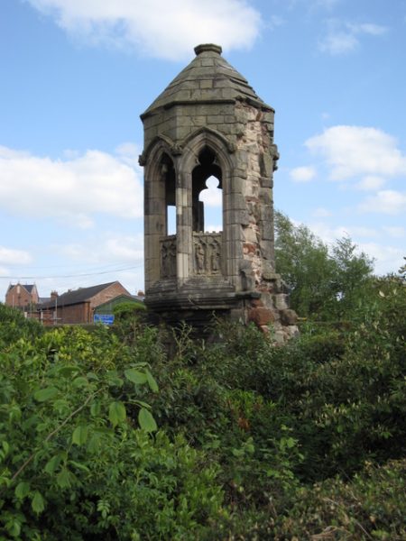 “A terminus was built at Abbey Foregate, opposite Shrewsbury’s Abbey Church, standing on the site of the former monastery’s refectory. Passengers arriving at the station were greeted by the sight of the 14th Century refectory pulpit, fenced off at the edge of the platform.” [6]
It and the platform are still there, and the area once occupied by the station is part of a car park.
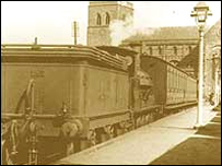
The adjacent image shows the pulpit in 2009, (c) John S Turner. [7]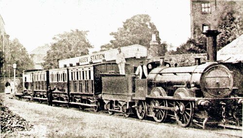 Train at Shrewsbury Abbey in 1870 behind a Bury, Curtis and Kennedy 0-4-2 locomotive built for the LNWR in 1847. [4]
There are a good range of pictures of the old station on the Shrewsbury Railway Heritage Trust site. [9] Here are a few as tempters!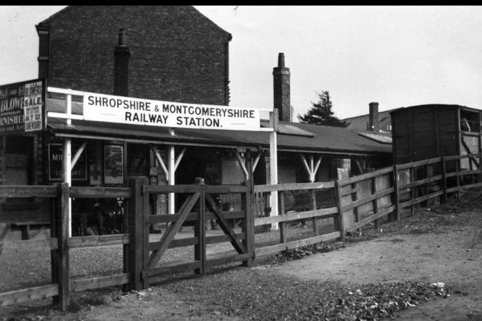
 With the Abbey in the background, the old station building looks rather forelorn. Just behind the photographer the station platform rose to be more accessible for the unloading of goods. [9]
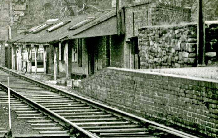 The ramp is clearly visible in this photo. [9]
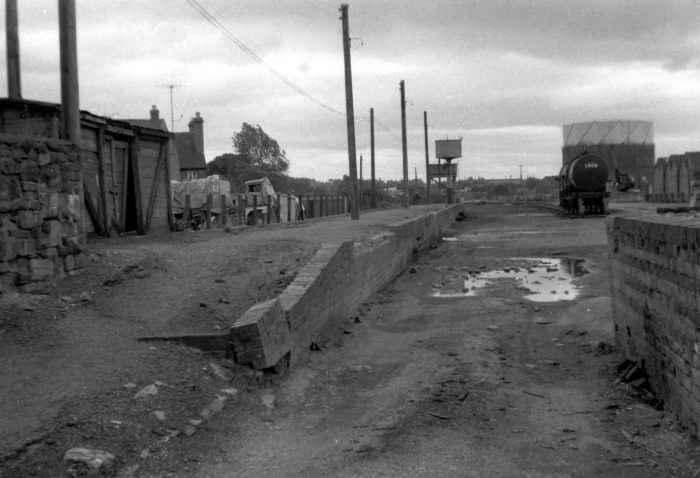
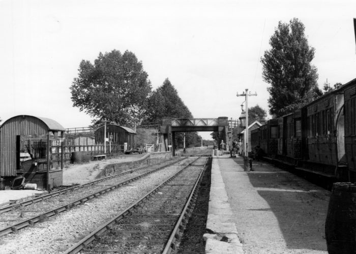
 Looking South (above) along the platform in the 1980s. [9]
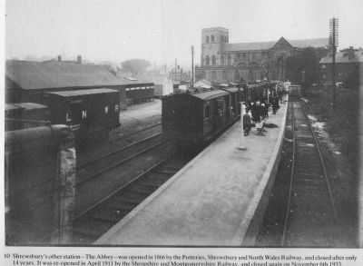
The adjacent image is probably from soon after the turn of the 20th century and shows station and Abbey together. [15]
The image below is taken from much closer to the station throat and probably shows the station in the 1950s when the station was in use by the military. [15]
 The station in use before closure in 1961. [9]
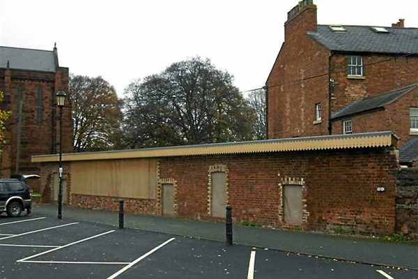
 The renovated building in the 21st century is shown above. [10]
Another view of the station is use is shown in the adjacent image. [6]
The double track railway line left Shrewsbury in a south-easterly direction, with a station at West Meole Brace before heading out into the countryside into lightly-populated farm land and land subject to periodic heavy flooding. Its largest engineering feat was the twin track viaduct over the Severn at Shrawardine. The line first opened on 13 August 1866 and according to the Shrewsbury Chronicle, large numbers of passengers turned up at Abbey Foregate Station to try out the new service, and got out at the other end determined to explore Llanymynech. Many walked up Llanymynech Hill, but others ‘sought sport in the River Vyrnwy, as well-filled baskets testified’. Unfortunately for the Shrewsbury and North Wales Railway, the novelty wore off quickly, and passengers numbers soon dwindled. Within a few months of opening, the railway was in deep financial trouble. Debt collectors turned up at Abbey Foregate and seized a train. After rapid negotiations the train was allowed to leave, but only with a bailiff on board. After sitting in a stationary coach for a few minutes, the bailiff stuck his head out of the window – to see the rest of the train disappear into the distance! He was later told a coupling chain had broken by accident, leaving his coach behind. A likely tale?” [6]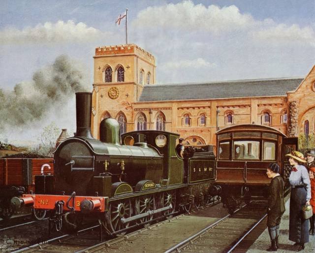 This picture comes from the Colonel Stephens website. It seems to be a flight of fancy when the accompanying text about locomotives is read. Although, the engine is one of the ex-LSWR ‘Ilfracombe Goods’ engines, the scene still has a sense of optimism and cleanliness which both seem to have been in short supply throughout the life of the line: “The railway ordered two new engines, 0-6-2 T, named ‘Pyramus’ and ‘Thisbe’. These were not a success, and were sold to the Government in 1916. The mainstay of the Railway then became three Ex LSWR ‘Ilfracombe Goods’ there were several oddities. The first loco was the minute 2-2-2 tank engine Gazelle, which served an inspection loco and then as a service loco on the Criggion branch. A Manning Wardle ‘Morous’ and an ancient 0-4-2ST ‘Severn’ (initially ‘Hecate’) of uncertain vintage completed the early roster. Three Terrier locomotives came in the 1920s but fell by the wayside in that decade and finally three ex LNWR ‘Coal Engines’ came from the LMS. A Ford railmotor set completed the roster.” [18]
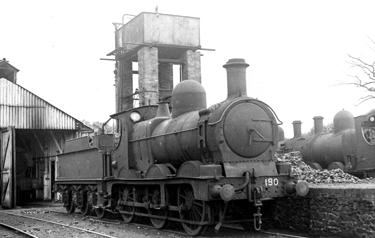 A ex-GWR ‘Dean Goods’ running as WD 190 as requisitioned by the War Department on shed. Note the old watertank which suggests that this picture was taken in the early days of M0D control. Thanks to Paul Moxon for these notes on this picture. [19]
As can be seen on the map below, for the first few miles the Shrewsbury and Welshpool Railway and the PS&NWR ran parallel and close to each other and Rea Brook . [8] “The company’s finances went from bad to worse, and on 21 December 1866, all services on the railway line ceased, while some of its assets were sold off. It was another two years before a train ran on the line again but services had to be reduced even further and the railway made into a single line, to cut running costs. Despite these economies, the company still found the cash to build a new branch line from Kinnerley to Criggion, with the aim of picking up revenue by transporting stone from the quarry at the foot of the Breiddon Hills.” [6] It was also intended to carry passengers, but the facilities were primitive. Apart from Melverley, all the buildings and platforms were made of timber. The branch had to cross the River Severn and it did so on a rickety timber viaduct.
“While the branch at Criggion was opened in 1871, a second branch was added between Llanymynech and Nantmawr the following year. This branch, which crossed the Cambrian Railway Company’s tracks at Llanymynech, allowed the Potts Line to take on extra freight traffic – limestone from the quarries at Nantmawr.” [6]
Despite the additional revenue, the PotteriesS&NWR continued to deteriorate. All possible economies were made, fares were even cut to encourage more passengers, but to no avail. In 1877 the company went into receivership. By 1880 the condition of the track had become so poor that a 25mph speed limit was imposed right along the line. Later that year the line closed completely. The Oswestry-based Cambrian Railway Company bought the section of the line between Llanymynech and the quarries at Nantmawr, re-opening it in 1886.
The rest of the line remained dormant until 1890, when a new company, Shropshire Railways “took over the line between Llanymynech and Shrewsbury, relaying the track. Unfortunately the cost of these line repairs ate up most of the new company’s budget and it went into receivership shortly after re-opening the line.” [6]
“For the third time in its short history, the owners of the Potts Line had gone bust, and it was to be another 17 years before trains ran along it again. All but abandoned, the station buildings and other structures, which hadn’t been in the best condition anyway, deteriorated still further, and in 1902 the wooden viaduct over the Severn at Melverley collapsed into the river.” [6]
Colonel Stephens built two lines in Shropshire: “The narrow gauge mineral railway linking the mine at Snailbeach with Pontesbury, which he took over in 1923, and the Potts Line.” [6]
“With the backing of local councils, Stephens formed the Shropshire and Montgomeryshire Light Railway company in 1907, and work began to clear the overgrown track. Once again the sleepers were replaced, the Melverley Viaduct was rebuilt and the line re-opened on April 13, 1911. But the newly-re-opened railway was hardly a success story. Traffic remained at a low level – hardly surprising given the fact that the stations were miles from anywhere, but Stephens was at least able to keep costs low with his collection of bizarre second-hand locomotives and carriages.” [6]


The strangest of all was called Gazelle, although its nickname, ‘the Coffee Pot’ was more descriptive. It is believed to have been the smallest locomotive ever operated on a standard gauge railway in Britain. Experimental rolling stock was the norm for the Potts Line. Economies in the 1920s saw the introduction of Ford railcars which were deeply unpopular with passengers because of the noise made by the pressed steel wheels. Then there was the double-decker tram bought by Stephens from London County Council. He modified this to run behind Gazelle by removing the top deck and the stairs. Gazelle and the tram are shown in the two small pictures above and the larger picture below. [6][18]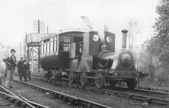 ‘Gazelle’ The one locomotive that says it all about Col. Stephens and the S&MLR. [18]
A BBC article says: “Money became tighter than ever in the 1920s as the line struggled to keep going. … All passenger traffic on the Criggion branch line ceased beyond Melverley, because once again the viaduct was inspected and considered unsafe. the S&MLR closed completely in November 1933.” [6] The BBC’s suggestion of complete closure is challenged by others. It was passenger services that ended in 1933: freight traffic continued, including on the Criggion branch (weak bridge and all), until the Army takeover. One source below mentions this.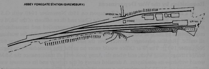 The station track layout in Shrewsbury in the 1920s. [15]
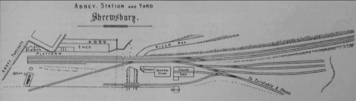 The station in the 1870s. [41: p25]
In June 1941, the War Department requisitioned the line from Shrewsbury to Llanymynech, and established a vast ammunition storage dump at a secret depot in Kinnerley. There were more than 200 huge storage sheds, camouflaged and decked out with turfed roofs and each was served by a railway siding. The line was busier during the war years than it had ever been. Before long, as many as 12 locomotives – including the Gazelle ‘Coffee Pot’ – were in steam at the same time.
The War Department spared no expense in maintaining the line and its structures. It improved facilities all along the line, including building major new sidings at Hookagate, where the Potts Line joined the main line from Shrewsbury to Welshpool, and completely rebuilding the viaduct across the Severn at Shrawardine. All this renewed activity on the main part of the line allowed stone to be carried from Criggion again, although Melverley viaduct was yet again declared unsafe in 1945. Only trains hauled by Shrewsbury-built Sentinel light locomotives were allowed to use the line until the bridge was rebuilt in 1947 by the Great Western Railway. This is the bridge that remains today. [6]
Shortly after the end of the war, the Severn floods were so bad they reached the top of the embankment at Shrawardine, and a bridge over a stream at Maesbrook was washed away, stranding a locomotive at Llanymynech. In 1959 the War Department closed its last depot and stone traffic by rail from the Criggion quarry ceased. The following year the line was returned to civilian status, to be operated by British Railways. But the writing was on the wall for the branch line and operations were run down. The last scheduled train from Shrewsbury to Llanymynech ran on 26 February 1960 and three days later the line closed. [6]
In the same year, BR removed all the track apart from sidings at Shrewsbury and today little remains of the Potts Line. The site of Llanymynech station is now a coal yard and the station at Criggion is split into two houses. Hardly anything remains of the Criggion branch line, and the stations at Llandrinio Road and Crew Green, which had wooden platforms, are completely gone.
The most substantial remains of the Potts Line are at Kinnerley, where most of the ammunition storage buildings – and even the rails running through them – still survive as shelters for livestock. There are also considerable remains of the Potts Line in and around Shrewsbury, especially at Abbey Foregate station.
Much of the trackbed was used as the base for Shrewsbury’s inner ring road, called Old Potts Way. The platforms of the station are still there, and an attempt to demolish the Potts Line station building, was eventually turned down by the local council in 2003.
In October 2008, Shrewsbury and Atcham Borough Council pledged £113,000 to help build a heritage centre in the old station building. The Shrewsbury Railway Heritage Trust applied for match-funding from the Heritage Lottery Fund and the building has been refurbished.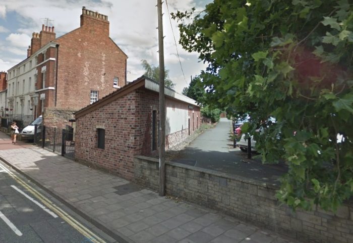
 The refurbished station building in July 2018. It sits boarded up awaiting a new life.
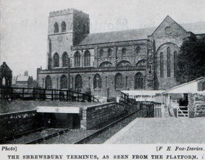
The adjacent image shows the terminus and the Abbey viewed from the station platform in around 1910, (c) F.E. Fox-Davies. [15]
The line from Abbey Foregate to Llanymynech and Criggion
The buffers were immediately behind the dwarf wall in the image immediately above. The road in the picture is Abbey Foregate. This station must not be confused with the station that was called Abbey Foregate. That station was to the south-east of Shrewsbury station, to the east of Severn Bridge Junction, on what is today the Shrewsbury to Wolverhampton Line. Despite its name, the nearest road was Underdale Road, not Abbey Foregate! [11] Our line is shown in blue on the Railway Clearing House Junction Diagram from 1912. [12]
As we have noted above the line followed closely that of the Shrewsbury and Welshpool Railway as it left Shrewsbury. By 1955 the OS Map no longer shows two separate railway lines over the length to the north of Meole Brace (see below) even though the lines were running in parallel still.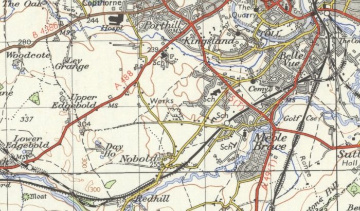
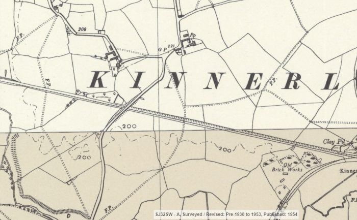
 The layout of the station tracks can be seen on the OS 1:10,560, 1949-1968 series maps as in the adjacent image. The maps in this area were published in 1954. [13]
Leaving the station, the line curved westwards and shown on the map below. It crossed Rocke Street/Reabrooke Avenue which was at that time a pedestrian underpass.
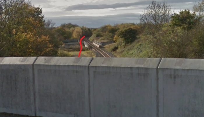
The line then bridged two railways. The first was the GWR to Worcester, the second, the Shrewsbury to Hereford line.
 Looking back towards the station from the location of Rocke Street underpass.
 Looking ahead along the line towards the West.
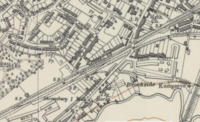 This 1954 map shows the two lines running parallel under the A5191, Hereford Road. [13]
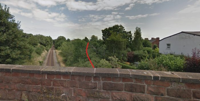 Looking East from Hereford Road showing the line of the old railway curving in under the road bridge.
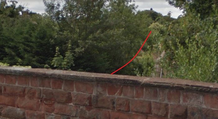 Looking West along the route of the line from the same bridge.
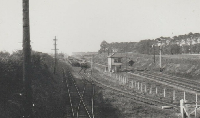 The two lines to the West of the A5191 before the B4380 bridge. The signal box on the map above is visible in the centre of the image, as is the fence dividing the two lines and in the right foreground the link between the two lines. This picture appears to have been taken from the footbridge visible in the next picture. [16]
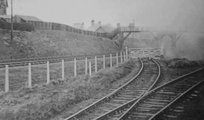 This image shows the link between the two lines and the footbridge beyond. [41: p16]
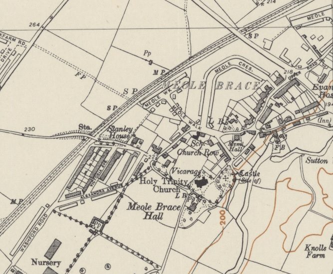 The two lines continue to run next to each other through Meole Brace Station. [13]
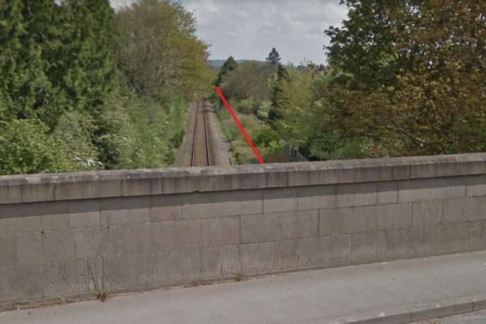 Before reaching Meole Brace Station the two lines passed under the B4380. This picture looks back towards Shrewsbury.
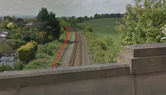 Looking ahead towards Meole Brace Station.
Meole Brace Railway Station opened in 1866 and closed in 1933. [14] The station facilities were very limited and the station only served the S&MLR. There was a wooden shed for passenger accommodation with a roof that sloped away from the platform. There was no canopy on the station building, although the passengers could use Stanley Lane bridge for shelter. Alongside the wooden building was a grounded wagon body which probably performed the function of the small goods shed. There were no sidings and no room for trains to pass.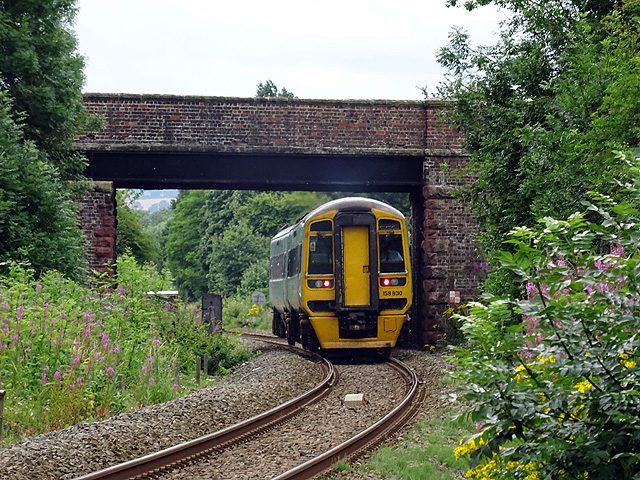 An Aberystwyth bound train passes the site of Meole Brace station, heading away from the camera. The main line here was opened as the Shrewsbury and Welshpool Railway in 1862. It was operated by the London & North Western Railway from the outset and then jointly with the Great Western Railway. Meole Brace station served the erstwhile Shropshire & Montgomeryshire Railway which ran parallel to the Shrewsbury & Welshpool (to the left of this view – under a separate span of the bridge) for about 2 miles. The station here, an all wooden structure, probably of single carriage length, was located to the left (out of shot in this view) mostly under the Stanley Lane overbridge. The Shrewsbury and Welshpool line now forms part of the Cambrian main line from Shrewsbury to Aberystwyth/Pwllheli. In this view, ‘Cambrian’ unit No. 158830 is operating the 11:30 service from Shrewsbury to Aberystwyth, © John Lucas. [17]
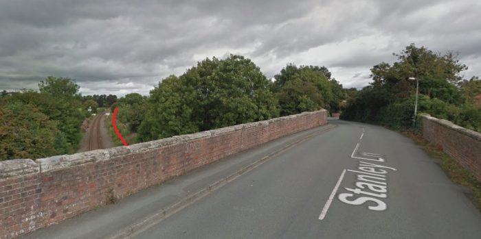 Looking back towards Shrewsbury from the Stanley Lane Overbridge. The Meole Brace station building was tucked under the bridge in the approximate location of the tree which is in the centre of this image.
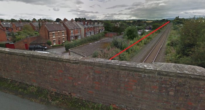 Also taken from Stanley Lane, the route of line can be seen heading Southwest alongside the present line to Aberystwyth.
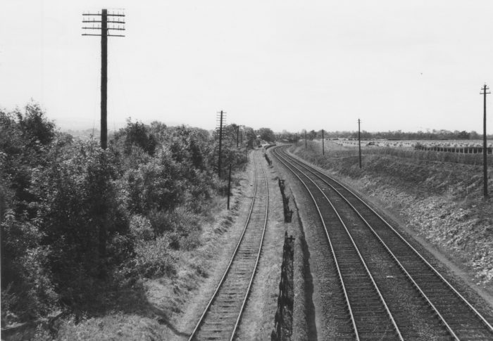
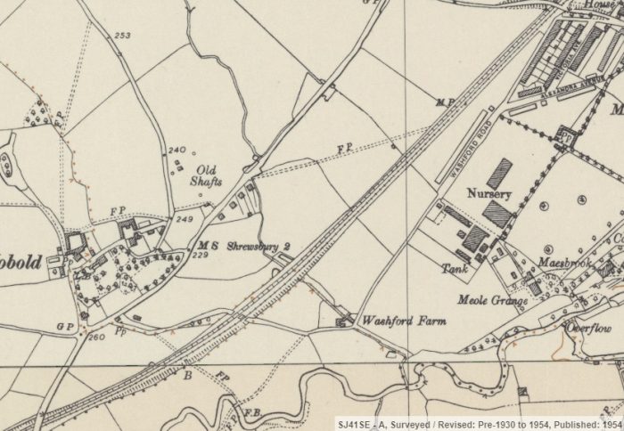 The two lines were still running next to each other as can be seen in the monochrome image above and on the OS Map. The Stanley Lane bridge is just visible to the top-right of this map extract. Two other roads cross the line on this map extract, one under (Washford Road) and one over (Longden Road) the line. [13]
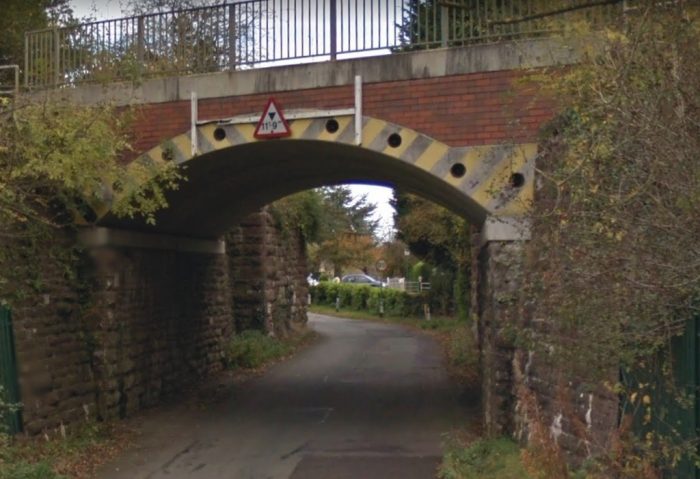 Washford Road underbridge, taken from the Northwest and showing the modern bridge carrying the live line and behind it an abutment from the old line.
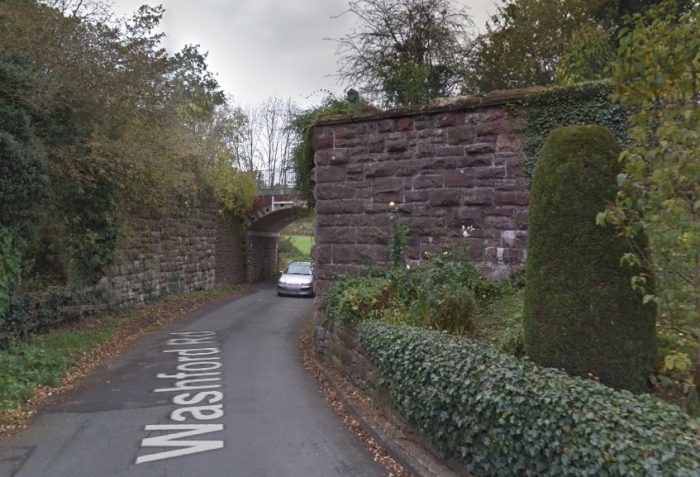 From the South East the abutments of the old line loom large and show that at one time there was a two track line running over the metal bridge.
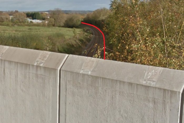 Longden Road bridge is newly reconstructed in the early 21st century. This view looks back towards Shrewsbury. The view immediately below looks Southwest along Longden Lane and shows the remains of what was the older bridge parapets.
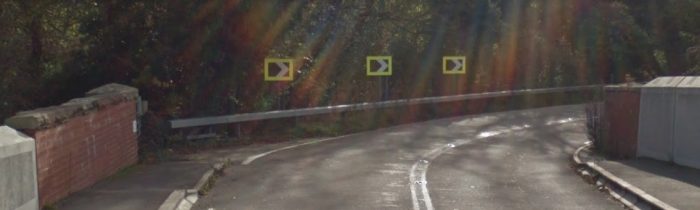
 The view ahead shows the modern railway crossing over the A5 on a newly constricted bridge. The old line still ran parallel at this point but it would never have had a bridge as it was long-gone before the modern A5 was built!
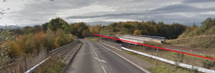 Longden Road runs parallel to the route of the line as it crosses the A5 and affords a good view of the modern line as well.
After the overbridge at Longden Road, the two lines took separate courses. The S&MLR diverted southwards and rose, past the site of two old quarries, to cross the Aberystwyth line on a skew bridge as shown on the map extract below.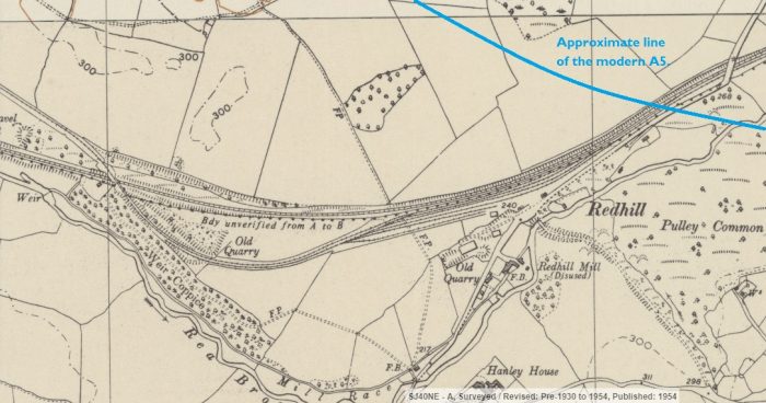 A 1930s guidebook to the line describes this section of the line as follows: “The gradient stiffens and climbing up through a charming belt of woodland the railway crosses the Welshpool line, and continues high up above the surrounding country to Hanwood.” [23]
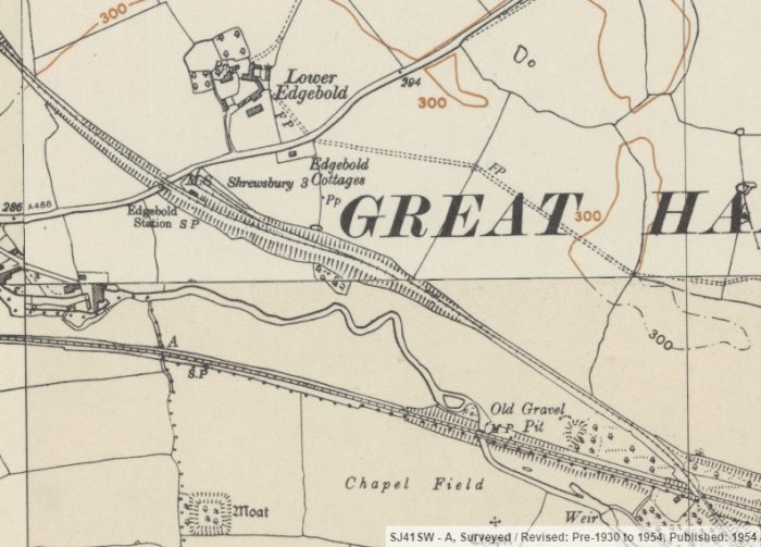 The next station on the line was Edgebold Station, sited just to the Southeast of the A488. [13]
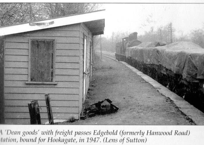 Edgebold station building was typical of most on the line, of timber construction with a roof sloping away from the platform face. It was sited on the North side of the line. The locomotive in this picture is most likely to be an ex-LNWR engine. There were goods facilities at the station which came off the line to the East of the station platform and ran behind the station building. [15]
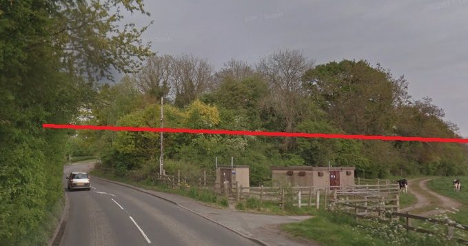 The line crossed the A488 via an overbridge. It had been on embankment for some time. The station location was among the trees at the centre of this image which is taken from the Southwest.
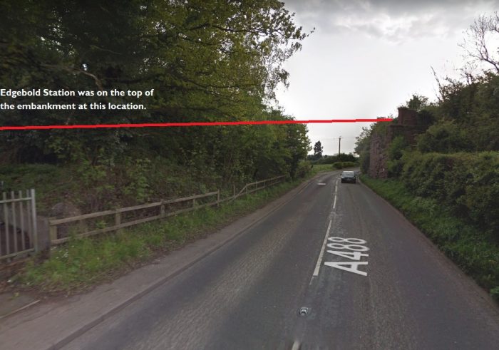 This image taken from the Northeast shows the remaining abutment of the overbridge.
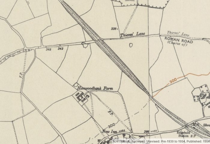 The railway ran in cutting through passed Thieves Lane and on towards the B4386, Horton Lane.
The 1930s guidebook to the line says: “A straight run from Edgebold and Cruckton Halt is reached at a point where the line is carried over the Shrewsbury and Westbury main road. From here the gradient descends to Ford Station. Close by are the villages of Crossgates and Ford: Crossgates situate in a pleasant udulating country with woods here and there dipping down to the Severn. Ford lies about half-a-mile from the river, and is but a small village, though within its broad parochial bounds are many lovely nooks and delectable habitations of all degrees. The church, which stands picturesquely upon a high knoll, is an interesting and beautiful little building of red sandstone and dates back to the twelfth century.” [23]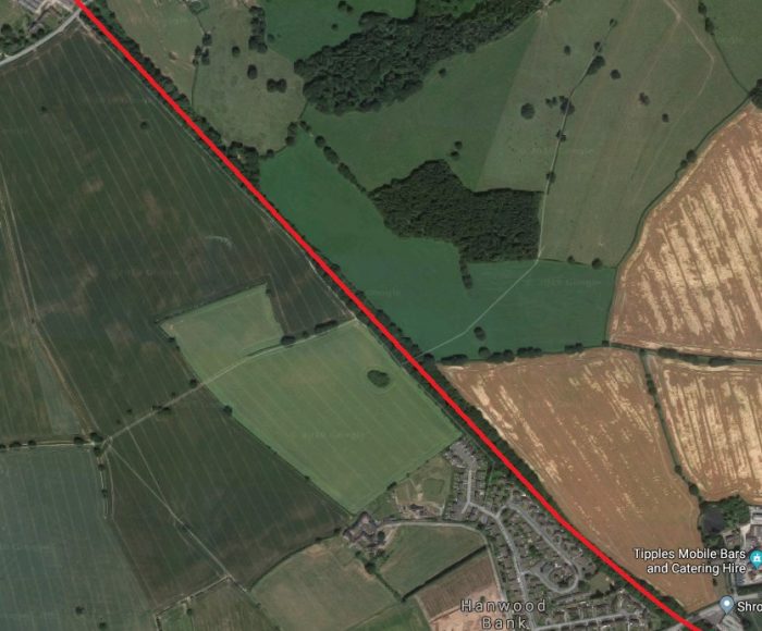 The location of the Thieves’ Lane Bridge can just be made out on the satellite image south of the woodland at the centre of the image. Thieves’ Lane can be picked out entering the image from the right but is lost after crossing the line of the railway.
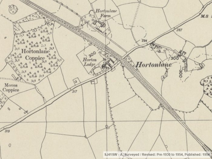 The railway passed close to Horton Lodge, by this time back on embankment and crossed Horton Lane via an overbridge. [13]
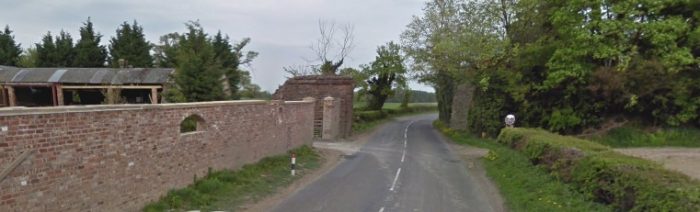 The bridge abutments are visible in this picture taken from the Southwest. To the Northwest of the bridge, the embankment has been removed over a short distance.
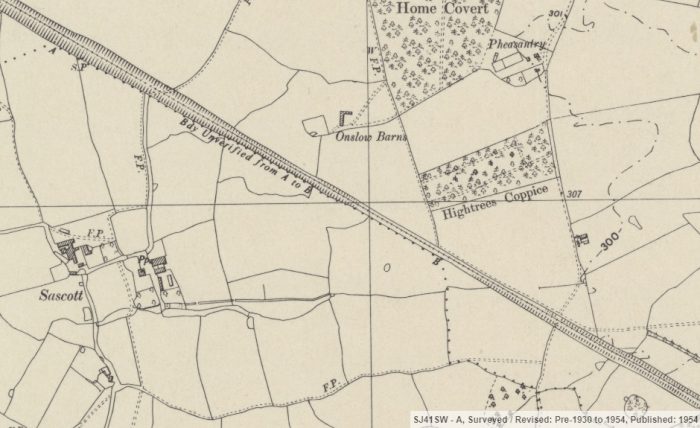
 The line continued in a straight northwesterly direction, alternating between bing in cutting and on embankment. On its way it crossed a minor road at level at approximately the location shown below.
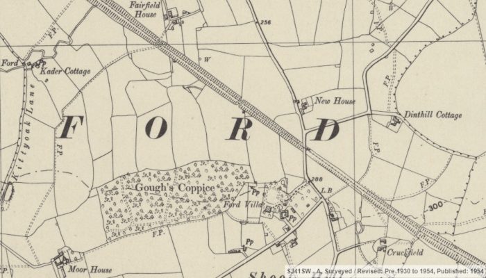
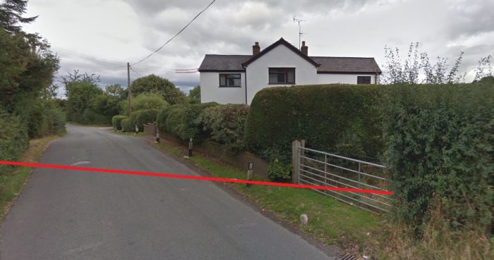 It continued from here on embankment passed Fairfield House, shown on the map extract above, before crossing the A458 on an overbridge and entering Ford & Crossgates Station. The A458 road has been realigned relatively recently. The 1930s guide says: “At Ford the railway crosses the Shrewsbury and Welshpool road, and in a mile two goes over the Severn, affording views to the traveller of a magnificent bend in the river, backed by a big belt of woodland which runs sheer up from its right bank.” [23]
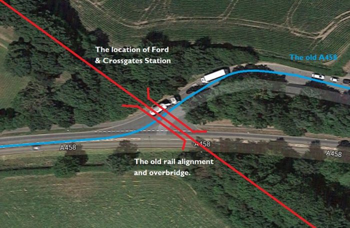
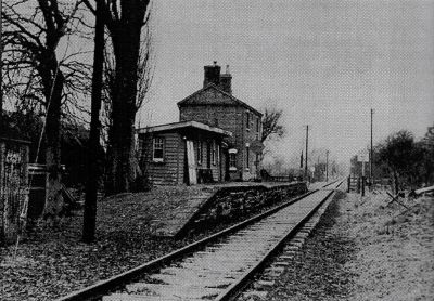
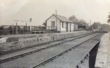 The adjacent image shows that the staion had slightly better facilities than those encountered along the line so far. The timber structure has a peaked roof and appears to be more substantially built and the platform in made of dressed stone and designed to accommodate longer trains! [20]
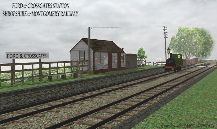 While searching the internet, I came across this computer generated image of the station which picks out the old bridge over the A458 and the grounded van body as well as the passing loop which was present at this station. The image was produced by Sketchupdezine (@sketchupdzine) and can be seen on facebook at https://www.facebook.com/sketchupdzine. [21]
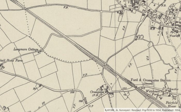
 This closer extract from the OS Map shows both the loop and a small siding. There are no obvious signs of the railway and its overbridge where it once crossed the A458. However, just to the Northwest of that bridge a country lane passed under the old railway. Tha cane be seem at the top left of the map extract. [13]
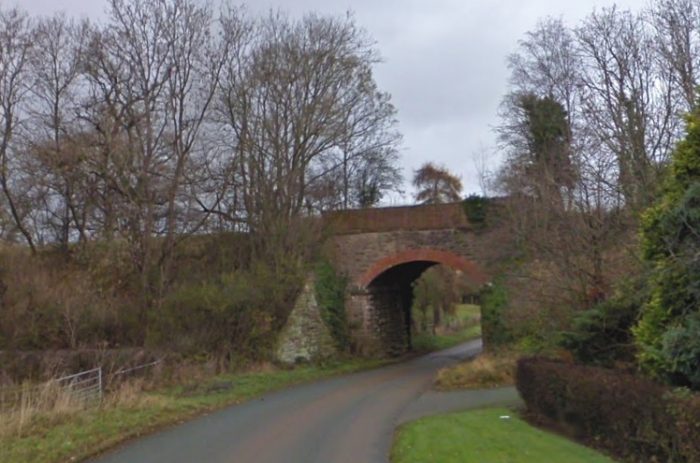
 The picture above is taken from the South and shows the minor road passing under the old railway bridge in 2009.
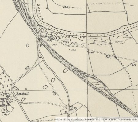
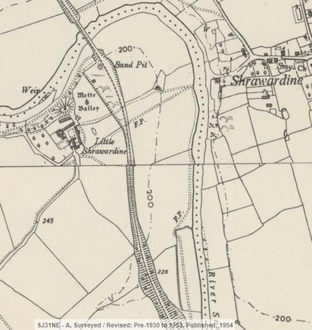
The line continues to the Northwest and eventually begins to run alongside the River Severn as shown on the adjacent map extract. [13]
The River Severn snakes round and the line crossed it on a major structure which can be seen on the next map extract. This bridge was in the form shown on the picture below.
Sharwardine Bridge was, says the guide book, “a massive structure, and was erected at [great] expense. A pair of double lines of wrought iron girders [were] carrled over the river deep down [in] its bed on four sets of stone buttresses, and three sets of three each of iron cylindrical pillars, making it the most pretentious bridge on the whole length of the railway.” [23]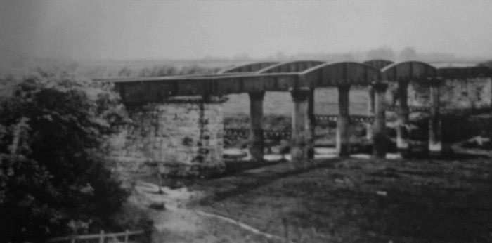 Sharwardine Bridge in 1903, © F.E. Fox-Davies. [41: p33]
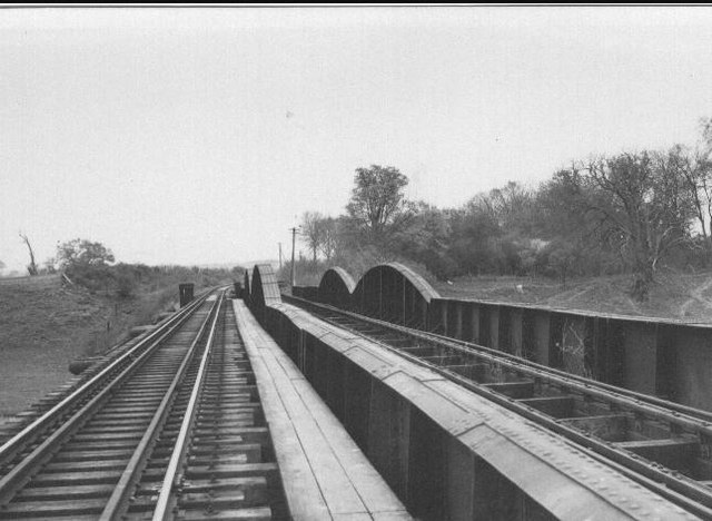
 The Railway Bridge across river Severn (1954). The river crossing of the River Severn by the former Shropshire and Montgomeryshire Light Railway is shown above. Taken during RCTS (Railway Correspondence & Travel Society) on 25th April 1954. The bridge was long ago dismantled, ©Ken Brockway. [22]
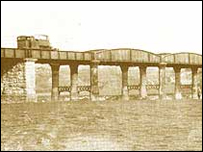
The same bridge is shown in this smaller image. [6]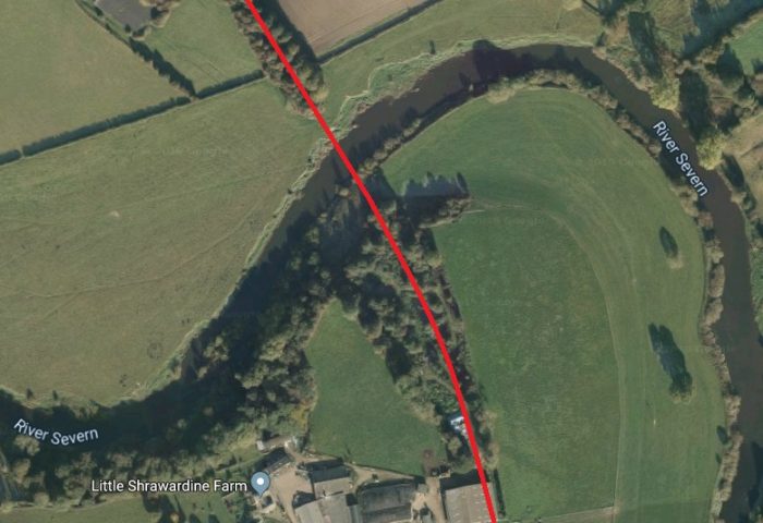
 The bridge location (above) in the early 21st century.
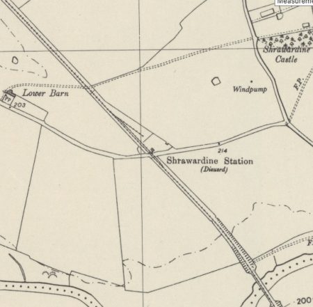
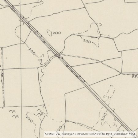
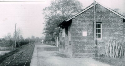
The line continued only a short distance northwest before entering Sharwardine Station which, like Ford & Crossgates also had a passing loop and small siding. These can be picked out on the adjacent map excerpt. [13]
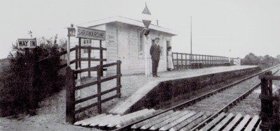
The station had a long stone-faced platform but a smaller station building than the one at Ford & Crossgates. The adjacent image comes from the early 1900s. [15]
“Shrawardine derives its name from ‘Shire-reeve-weodine’, thus marking it as the residence of the Saxon sheriffs before the Norman Conquest. The church contains little of interest, apart from a Norman font.” [23]
The line continued in a northwesterly direction as illustrated on the map extracts adjacent and below.
The next road crossed was close to Pentre and can be seen on the third of these three maps excerpts.
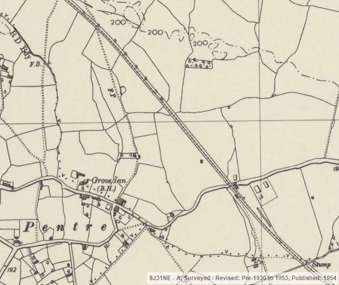
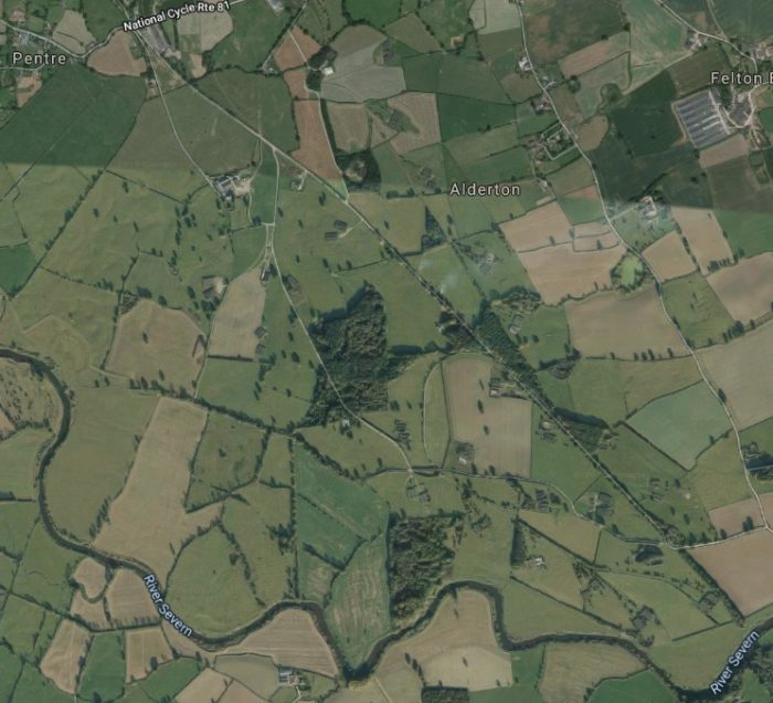 Tell-tale signs exist on the satellite image above which show that the area north and west of the river was used for more than farming. Remnants of old railways exist in the form of their trackbed. We will come back to this area in a future post. Sharwardine station was in the bottom right of this satellite image at the location shown below – just after the first run of trees northwest of the River Severn.
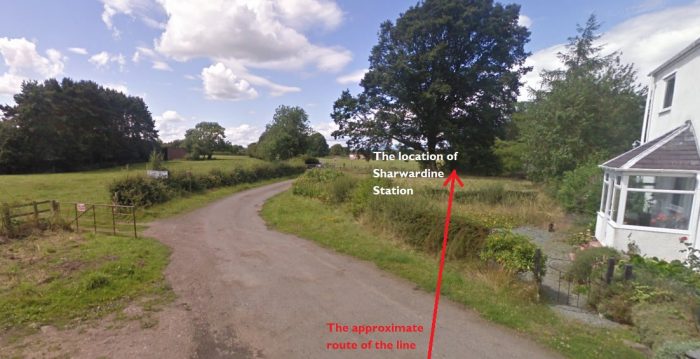 From this point to Pentre and beyond the line of the railway has been tarmacked as shown below.
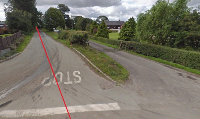 Looking back along the line of the railway towards Sharwardine. Nesscliffe and Pentre Station was to the right of the line between the access road and the railway.
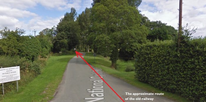
 Looking ahead (above) to the northwest. There is a strong clue as to the use of the land in the bottom left of this picture.
The adjacent image makes the status of the land much clearer! Looking towards Kinnerley from Pentre in 2019, (c) Bill Lloyd, Disused Railway Lines of Britain. [26]
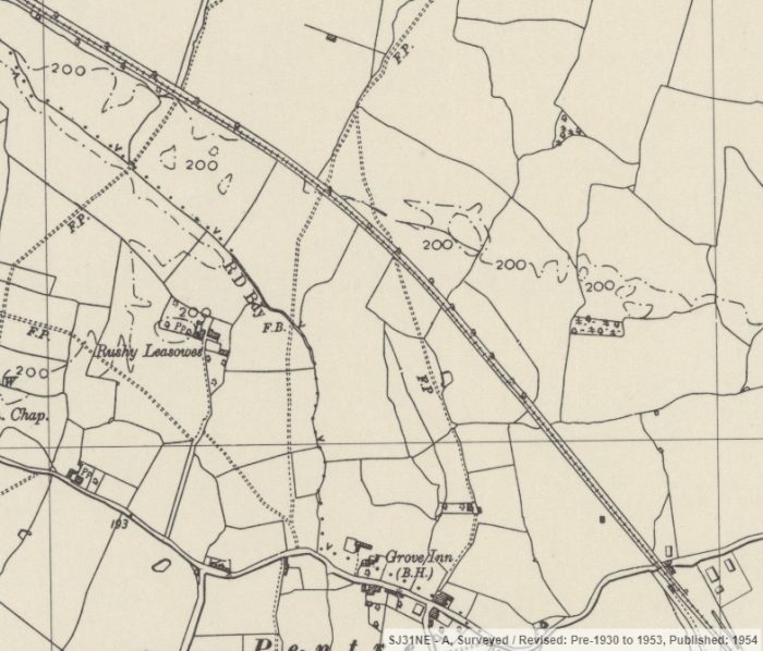 The line north of Pentre. The Nesscliffe and Pentre Railway Station can just be made out in the bottom right of the OS Map extract. [13]
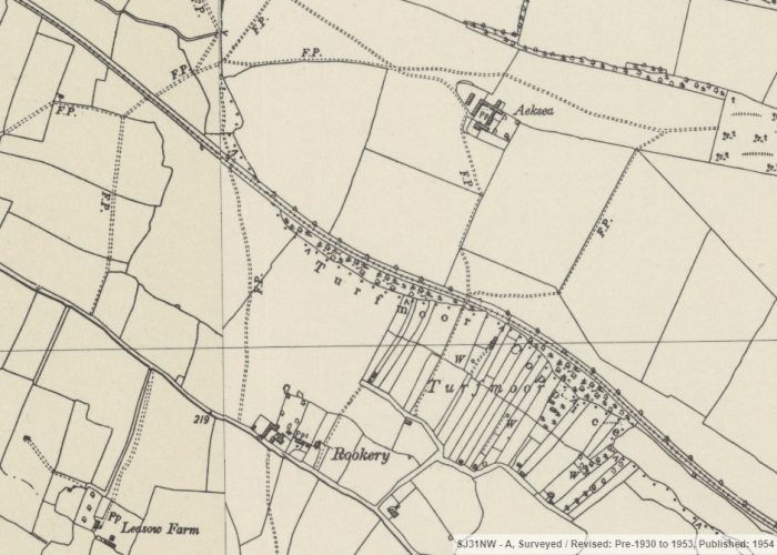 The line passed through Edgerley Halt and on to Kinnerley Junction Station. [13]
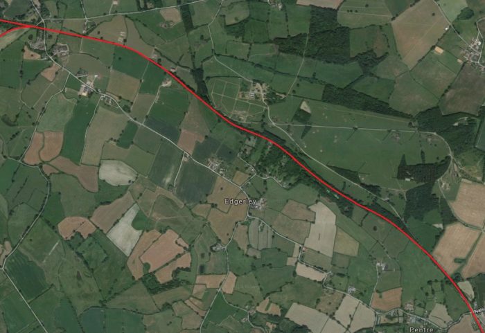 Again, north of Pentre, there are telltale signs on the satellite image of the past use of the land.
Just before reaching Kinnerley Station the line passed under a minor road. The bridge pilasters still exist today but the line of the railway has been filled in.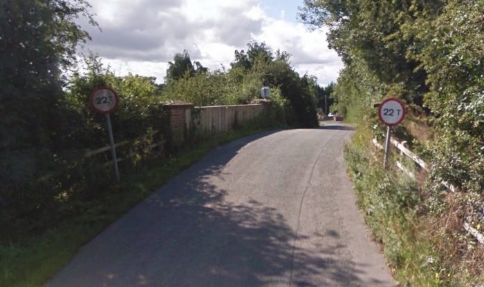 The station bridge from the North in 2010.
 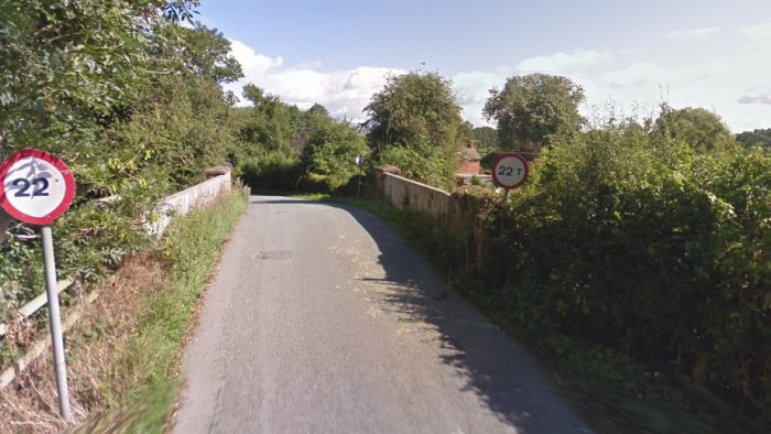 The station bridge from the South in 2010. Interestingly, although the bridge has been filled there remains a weight restriction. This must call into the question the quality of the infill work!
 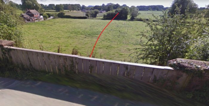 Kinnerley Station road bridge, looking back towards Pentre in 2010. The cutting has been filled in and the bridge parapets replaced with wooden fencing. The route of the S&MLR is shown by the red line.
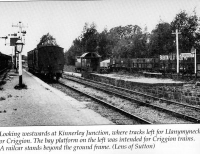 Kinnerley Station was the junction station on the S&MLR. One line continued to the West to Llanymynech and the other, South towards Criggion [13]
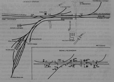
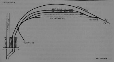
The adjacent sketch plan shows the track layout in the area of the station and on the branch-line. [15]
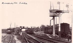
The adjacent picture shows the station looking West towards the junction. [15]
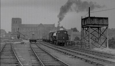
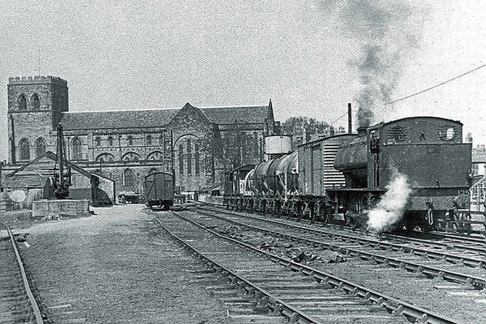
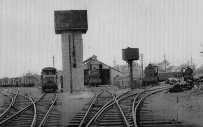
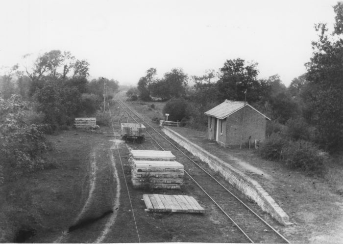
The image directly below shows the engine shed and water tower at Kinnerley in 1955. [15]
 The adjacent image looks back towards Shrewsbury through the station at Kinnerley. The nearby road bridge can be seen at the end of the platform. The image below is similar. [24]
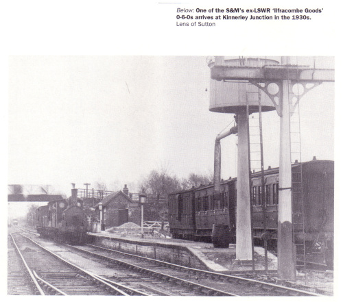
 This excellent picture of Kinnerley Station is taken from the Colonel Stephens Society Website. [25]
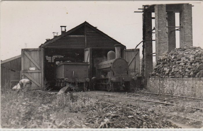
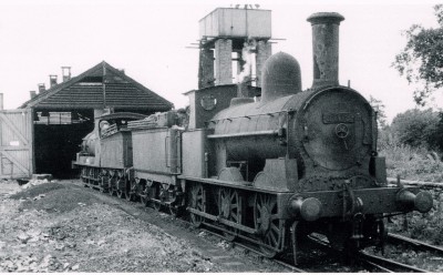

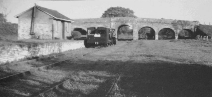
 Another two pictures of the engine shed at Kinnerley. [25][15]
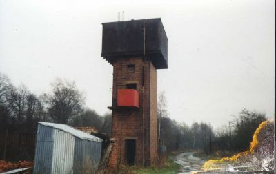
The images immediately below are more recent. They show the engine shed and water tower in the 1990s (c) Ken Owen [15]
Further below are more recent images of the site taken in 2019, (c) Bill Lloyd, Disused Railway Lines of Britain. [26]
Like other stations on the line, Kinnerley station was opened in 1866 and closed in 1933. [27]. It was a mile from Kinnerley village and served as the engineering headquarters of the railway. Engine sheds and repair shops were provided, and the station site covered some acres of ground. All trains started and finished from Kinnerley. It was the working centre of the system. [23] The water tower in 2019, (c) Bill Lloyd, Disused Railway Lines of Britain. [26]
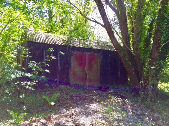 Corrugated iron building on the station platform, (c) Bill Lloyd, Disused Railway Lines of Britain. [26]
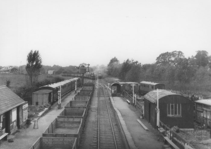 Kinnerley Station with the junction visible in the background. [25]
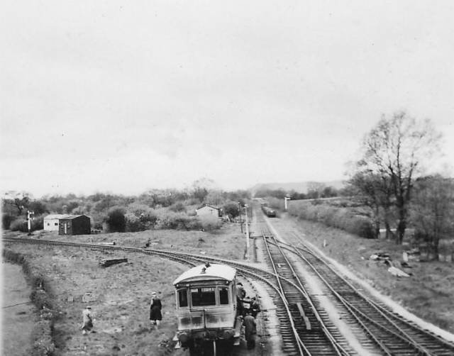 Kinnerley Junction. [28]
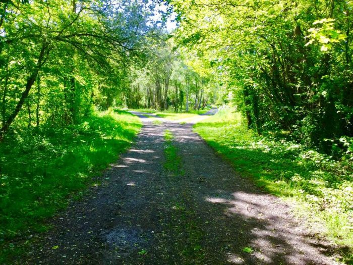 The location of Kinnerley Junction in 2019, (c) Bill Lloyd, Disused Railway Lines of Britain. [26]
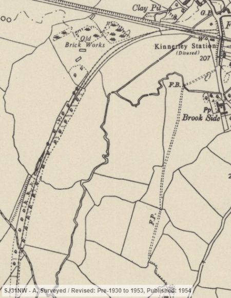
Kinnerley to Llanymynech and beyond
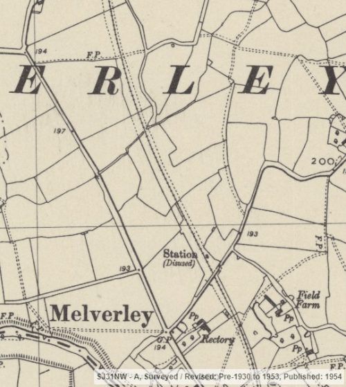
The line from Kinnerley to Llanymynech travels in a straight west-northwesterly direction along the Vyrnwy Valley [23] through Wern Las Halt and Maesbrook Station before eventually turning South into Llanymynech station.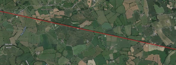
 There is no sign of the presence of the railway at location 1 in the satellite image above. All evidence of the bridge over the railway shown on this OS Map extract has long-gone. [13]
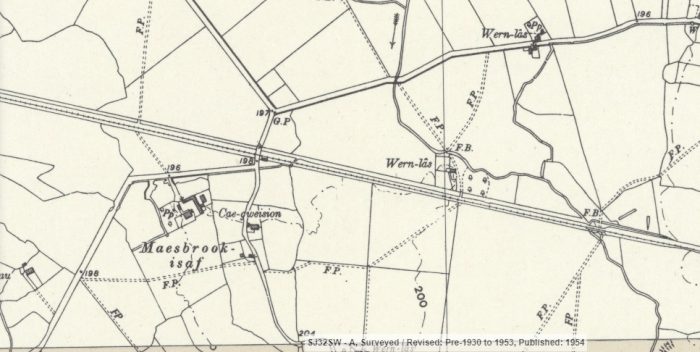 Wern Lea Halt is shown on this map extract to the east of the minor road. The route of the line is shown below looking back towards Kinnerley.
 Google Streetview also provides a view looking ahead along the line to the West. The location (‘2’ above) of these two pictures is at the extreme right of the map extract below.
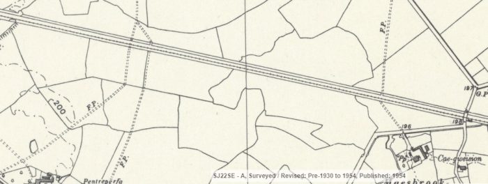 The line continues west by northwest towards Maesbrook Station. [13]
 Maesbrook Station is at location ‘3’ on the satellite image above. It is shown on the OS Map excerpt at the right side of the image. [13]
The adjacent image shows the approach to the station from Kinnerley. The crossing-keeper’s house dwarfs the station building. The road ahead is crossed at grade. [15]
The next image (adjacent) shows the station during World War 2. The picture is taken looking back through the station towards Kinnerley. [15]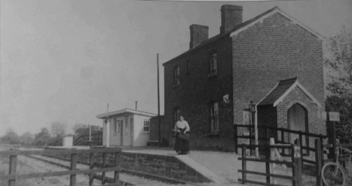 Maesbrook station and crossing-keeper’s house in 1911, © F.E. Fox-Davies. [41: p36]
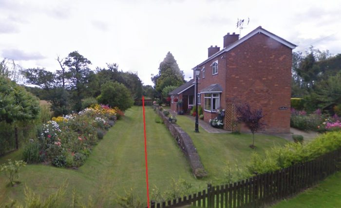 Maesbrook station in 2009, showing the old platform face and station building. This picture looks back towards Kinnerley.
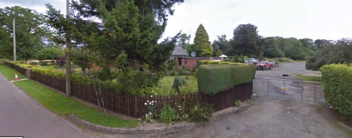 The old station yard at Maesbrook which was on the South side of the line. This view looks to the East from the road, back towards Kinnerley.
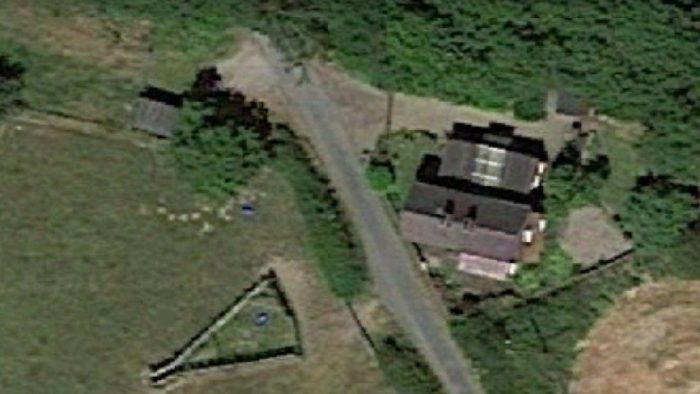 The next minor road was crossed at level. The Crossing-keeper’s cottage remains in place as the satellite image above shows.
 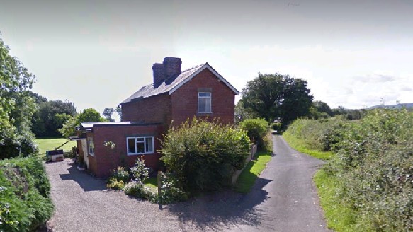 The Crossing keeper’s Cottage sits next to the minor road. The railway ran to the left of the cottage back towards Kinnerley.
 Taken at the same location looking West the line passed through the modern gate and on to the right of the avenue of trees.
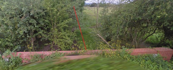
Then next road encountered was the B4398, close to Llwyntidmon Mill not long after the line had crossed the River Morda This is location ‘4’ on the satellite image further above. The bridge is shown here looking from the Southwest.
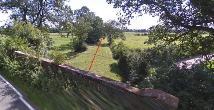 The Google Streetview image shows the route of the old line looking back towards Maesbrook. As can be seen the line has been filled in.
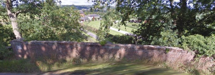 And forward towards Llanymynech. The line travelled to the left of the buildings visible through the trees.
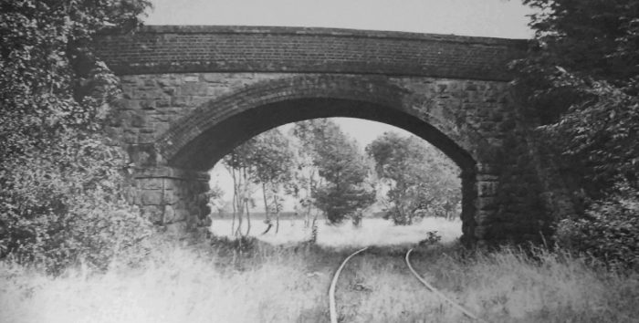 The bridges along this length made provision for a double-track railway. This picture was taken in September 1955, © WEH-LYN collection. [41: p37]
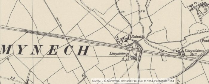 The location that we have just looked at appears on the right side of the OS Map extract above. The next road encountered was only a matter of a few hundred metres ahead close to the small hamlet of Llwyntidmon. [13]
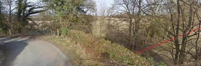 The view from the South showing the line looking back towards Llwyntimon Mill.
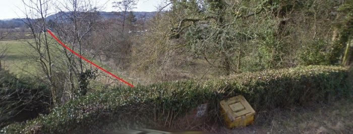 From a similar position looking West towards Llanymynech.
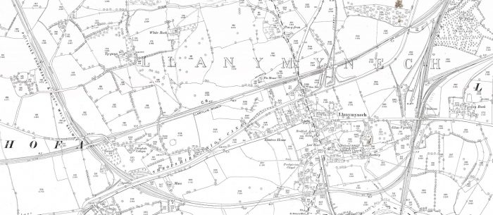
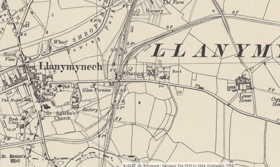 Llanymynech Station served as a double junction – the S&MLR arrived from the East and left towards the West, and the Cambrian Railways line serving Welshpool and Oswestry, ran roughly North-South to the East of the Village centre. [13] The layout of the lines is highlighted schematically on the satellite image below. The S&MLR in red and the Cambrian in green. the River servern flowed just to the South of the Village and can be made out on the OS Map above.
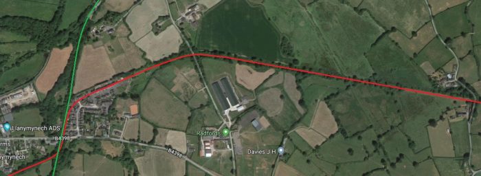 Llanymynech Station became an important junction station. The village was not significant in itself but its location was defined by geography as a hub point for local mineral extraction and later industrialisation. The Cambrian Mountains at this point are made of limestone, with numerous river valleys making extraction of ores relatively easy to the point where they congregate towards the main markets in England, at Llanymynech. [29]
“The country around Llanymynech is hilly and romantic. and almonds with minerals: a large quantity of limestone is quarried, some of which is burnt into lime. Copper ore is als found here, and [two centuries ago] valuable lead mines were In operation. The great hill called ‘Llanymynech’, which is a prominent feature, rises to a height of nearly 900 feet, and is celebrated for the beautiful and extensive views obtained from its summit. Offa’s Dyke, the historical boundary line between England and Wales, may be traced for some distance along the hill. … There is a cave on the hill known as Ogof, or the Giant’s Grave, which is supposed to have been formed by the Romans. who it is known wonted several copper, lead, and silver mines in the neighbourhood.” [23]
From the early Britons through to the Romans, Llanymynech lay on the route from the mines to the market towns of both Shropshire and Northwest England. The Weston Branch of the Ellesmere Canal from Frankton Junction, had been similarly constructed for this purpose in 1796. [29] It can be seen on the OS Map extract centred on Llanymynech village above. The village was in both the counties of Montgomery and Salop. [23]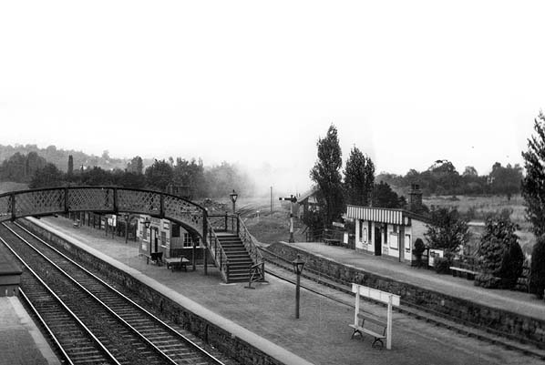 A view of Llanymynech station seen looking north from the road overbridge in the 1920s. The S&MLR platforms and station building can be seen to the right with the S&MLR curving away towards Kinnerley in the central distance. [33]
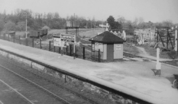 The approach to Llanymynech station, © John Keylock collection. [41: p38]
 A similar view from the road overbridge in 2016. There is now a housing estate extending over what was the line of the S&MLR. The adjacent sketch map shows the site of the depot for the line at Llanymynech. [15]
Something of the complexity of the railways in the immediate vicinity of Llanymynech can be gauged from the OS Map extract below. The dismantled railway prominent towards the top of the extract is the former Llanfyllin Branch which crossed the Potteries, Shrewsbury and North Wales Railway which became the S&MLR, also dismantled in 1954 and visible on the left of the extract. The layout of these lines is highlighted on the older 1876 OS Map below.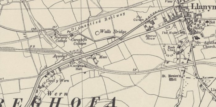
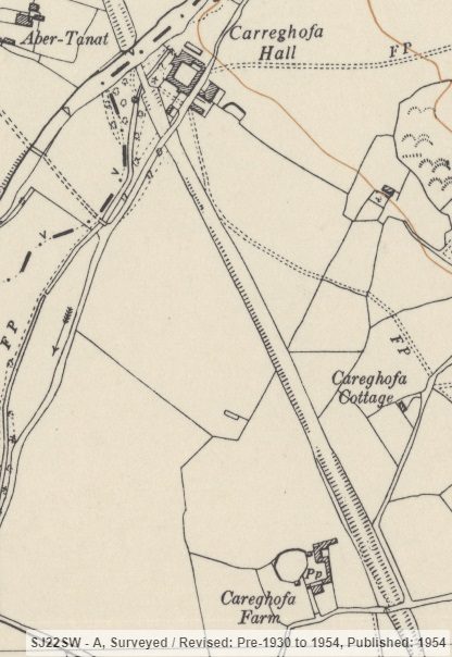
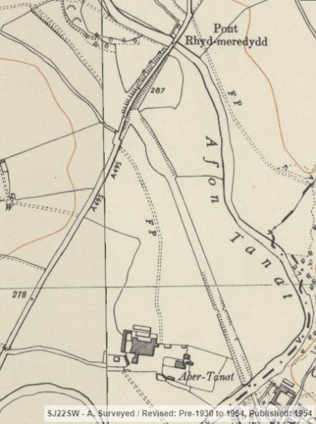

 Travelling North from the canal the line passed Carreghofa Hall and crossed the Afon Tanat before it approached Blodwell Junction which can be seen in the monochrome image below.
Given the complexity of the various railways and tramways in the area to the West of Llanymynech, this area would warrant a separate investigation and is really beyond the scope of this post.
Nonetheless, for the sake of completeness, it may be helpful to complete the length of the line to the quarry at Nantmawr which was the target of those who planned the full length of the line in those early years.
Perhaps over this length you will be satisfied with the extracts from the OS Maps with the hope that a further study can be undertaken in the future.
Given the aim of this and subsequent posts to provide details of the line which served the Nesscliffe area close to Kinnerley, and then the extent of the military railways in the area, this seems to me to be reasonable.
Blodwell Junction railway station was a station in Llanyblodwel, Shropshire, England. The station opened on 18 April 1870 as Llanyblodwel before being renamed in 1904. The station closed to passengers on 15 January 1951 and closed completely on 6 January 1964. There is no trace of the station today. [30]
The tracks remained in use to serve Nantmawr Quarry until 1984 when the entire line was closed by British Rail and the line was left in situ from Blodwell Junction to near Oswestry. The line has since been cleared and is now under the co-ownership of both the Cambrian Heritage Railway and the recently-reformed Tanat Valley Light Railway.
![]()
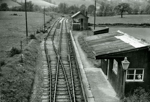
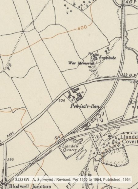 Blodwell Junction was the point at which the S&MLR met the Tanat Valley Light Railway. It is shown in the adjacent image in 1962. The picture Illustrates well the rudimentary nature of the facilities provided on the Potts line. Image © copyright Ben Brooksbank and licensed for reuse under this Creative Commons License. [4]
The railway clearing house diagram shows both the S&MLR (in green) and the Tanat Valley Light Railway (in orange).
The Tanat Valley Light Railway opened in 1904 and created the Junctions at Blodwell.
Grace’s Guide affirms that: “Part of the line, from Blodwell to Nantmawr, survived for many years as something of a forgotten part of the national network.” [5]
These two OS Map extracts from 1954 get us to Nantmawr. [13] Which is only a very short distance North of Blodwell Junction.
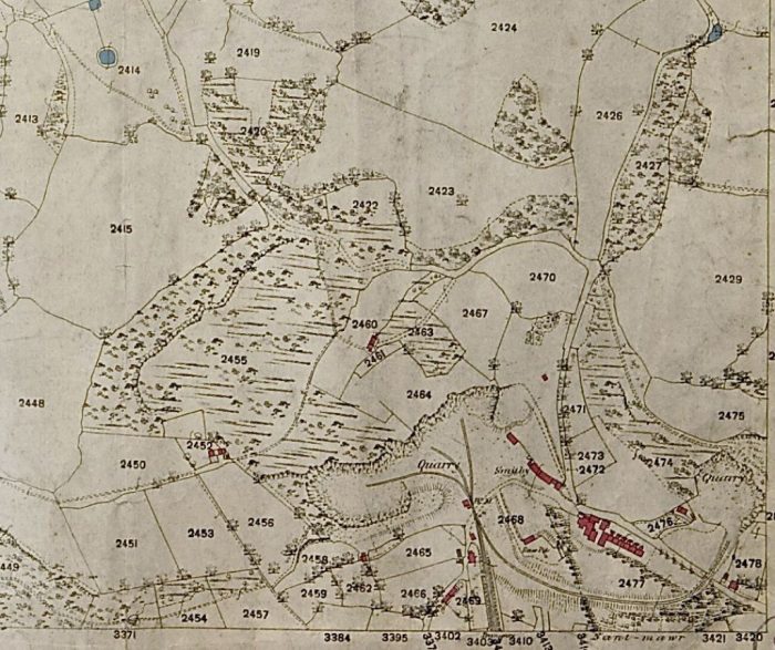
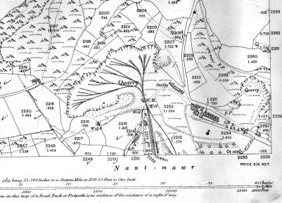 These maps of Nantmawr Quarry are taken from the Oswestry Borderland Heritage website. [32]
The line to Blodwell was by the Oswestry-based Cambrian Railway Society during 2004, and efforts are under way to re-open the line as a heritage railway. [5] The Tanat Valley Light Railway Society now operates at the station location. [31]
Kinnerley to Criggion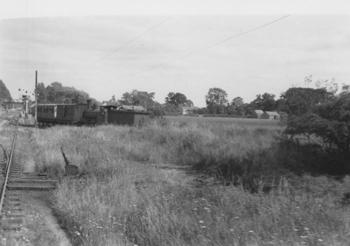
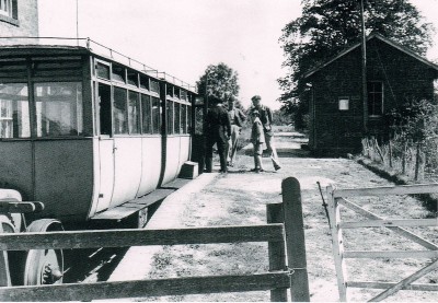
 In the image above, a short train heads away from Kinnerley along the Criggion branch line. [34]
At Kinnerley, the branch to Criggion heads South from the West end of the station complex. It is about 6 miles long. The stations were Chapel Lane, Melverley, Crew Green, Llandrinio and Criggion.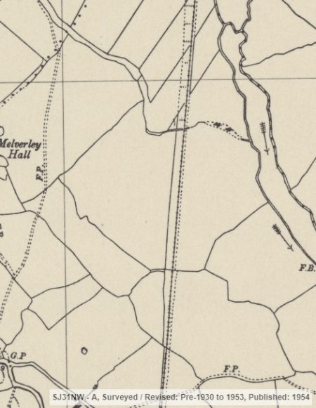
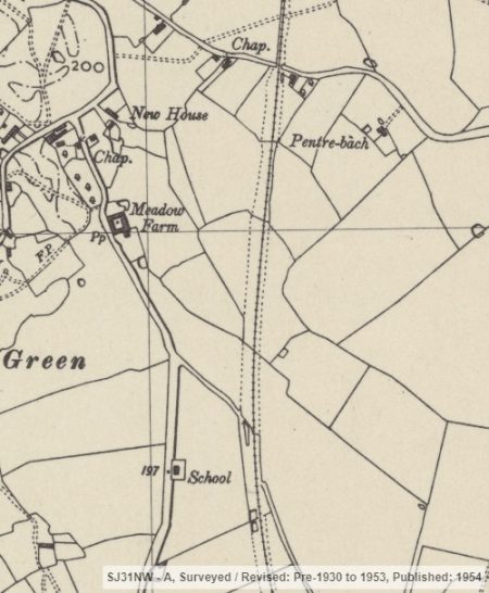
The line’s guide book says: “The Criggion section, which was constructed mainly for obtaining access to the valuable stone quarries on the Breidden, was not opened for traffic for some time after the trains had recommenced running on the line between Shrewsbury and Llanymynech. The great wooden bridge which carried the railway over the Severn at Melverley had long ago disappeared, having been swept sway by the floods, and the clearing of the line and the building of a new bridge cost some £8,000, in addition to £32,000 spent on the renovation of the main line.” [23]
The line headed South, crossing a number of small drainage brooks streams or channels. [13]
The first road encountered was Northeast of Melverley Green. It was a minor road which the line crossed, as suggested by the adjacent OS Map, at a height above the road. There is no sign of this being the case in the 21st century. [13] This suggests that there may have been an at-grade crossing at this location rather than a bridge over the road.
The picture below shows Chapel Lane, the location of the likely road crossing, the red line shows the route of the old line heading South from Kinnerley. The picture is taken from the East.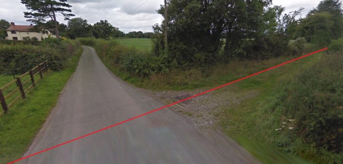
 The first station on the line, according to the guide book [23] was at Melverley. It can be seen on the adjacent OS Map extract from 1954. There was, however, actually a small station halt at Chapel Lane, which is the narrow lane in the picture above.
I believe that the ‘portrait’ shaped photograph immediately below is taken from a vantage point along the line North of Melverley. It illustrates the bucholic nature of the line and was taken in the 1930s and is part of the archives at the Tate Gallery, (c) John Piper [38]
Melverley Station is shown in the landscape photograph below, I believe the image is taken from the South and from the road over-bridge. [34]
The road bridge is shown in the second, third and fourth landscape images below and the station building can be seen beyond. [15]
In 2010, nothing is visible of the station or bridge. The bridge has been removed.
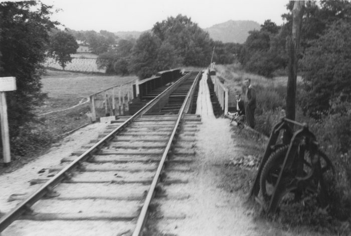
 The station and bridge with an army railcar on a railtour in 1958. The bridge had a weight restriction and was demolished soon after the railway was closed, © A.M. Davies. [41: p55]
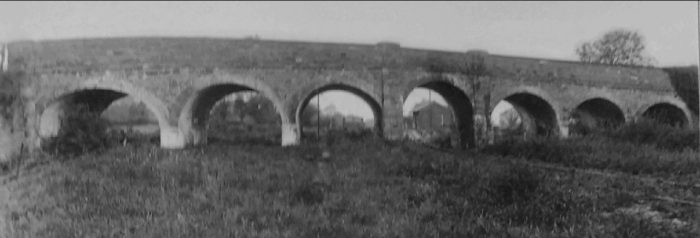 The brick-arched road bridge at Melverley was unusual. None of the arches had the same dimensions, © A.M. Davies collection. [41: p55]
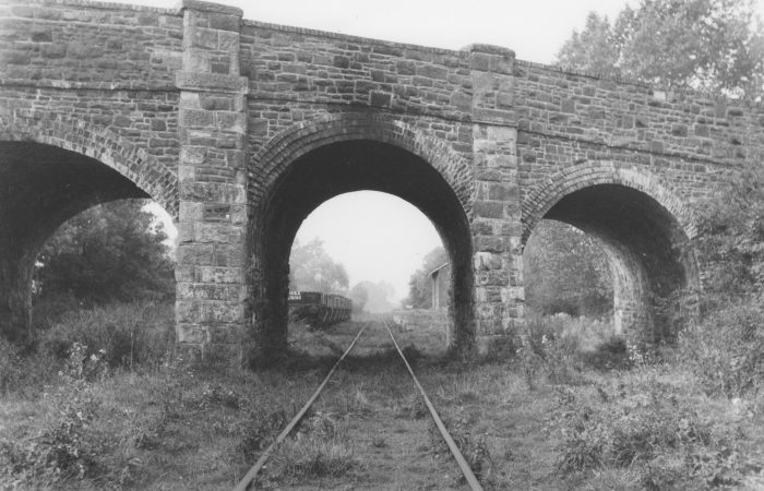
 South of Melverley the line curved towards the West, and it did so it crossed the River Severn.
We have noted already that the original bridge over the River Severn fell into disrepair and was wached away by floods. When renovating the line Colonel Stephens had to construct a replacement bridge.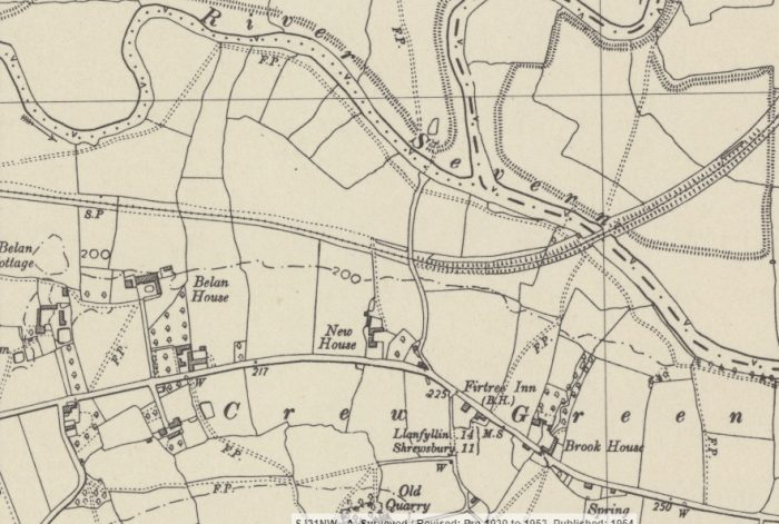
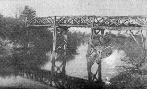 The first Melverley Bridge! [36]
The Colonel Stephens Society Website says: [36]
“Melverley Bridge was always the Achilles heel of the Shropshire and Montgomeryshire and its predecessor companies. The Potteries Shrewsbury and North Wales’ deeply eccentric creator Richard France had crossed the Severn twice, his tortuous approaches to his quarries; and would have built another at Shrewsbury if he hadn’t run out of cash. He built a robust iron structure at Shrawardine but the branch to the Criggion quarry (in the Breidden hills) was far more cheaply built, the river being crossed by a far less substantial structure near Melverley, after which it came to be named. Like most railway bridges built in this part of the world at the time, the bridge was economically built of timber with 7 long 38ft spans, making it technically a viaduct. The spans were timber trusses sitting directly on timber piles, a common enough railway structure at the time and very similar in general form to some of Brunel’s near contemporary viaducts (described by his assistant Peter Margery as ‘Type C‘). The viaduct, like Brunel’s, looked spindly but such viaducts lasted in use for fifty years and more. However, perhaps crucially, type C viaducts were used for crossing tidal creeks only, whereas France intended the Melverley Bridge to resist the Severn’s fearsome winter flow.
The Breidden branch to Criggion quarries had been opened with, or even before, the main line in 1865/66 for mineral traffic and a limited traffic operated over its single line. By May 1870 the company felt it was ready to be opened for passengers but there was long correspondence and at least two inspections before Colonel Rich reluctantly agreed to this in his report of 17 June 1871. Although the bridge was reported by Rich as of ‘sufficient strength’ it is characteristic of all timber bridges that they need much care and maintenance. It was usual to replace main timbers about every eight years and timber bridges were usually replaced by iron in the 1880s after a life of 20-30 years. Unfortunately maintenance was notable by its absence on the bankrupt Potts so although still virtually new by railway standards the bridge was in dire trouble by 1880. Following a complaint by a Worcester doctor taking water samples from the river below on 24 April, the BoT notified the Potts Board but Albert Judd, their GM, reported the bridge satisfactory. On the basis of this they responded to the BoT on 26 May, who were very sceptical following some earlier incidents on the Potts, and ordered an inspection of the whole railway by Colonel Rich. He inspected and reported on 9 June and, no doubt properly horrified by what he saw, recommended that it was unsafe to carry traffic. He described the bridge (which he named as Crewe Green bridge) thus
‘…constructed entirely of wood, which is so much decayed that two of the tripod booms have given way. These have been supported in a temporary manner but every boom is more or less rotten and the decking and the longitudinals, which carry the rails, are quite rotten. This bridge is about 1 foot out of level and about 1 foot out of line. The Company work traffic on the Briedden Branch with a small contractors engine that weighs about 16 tons but I do not consider this Bridge safe for traffic.’
That was it. The Railway shut the Branch to passengers from Wednesday 16th June, but goods which were still scheduled continued to operate on Wednesdays and Saturdays. However In the light of further criticisms contained in the Rich’s report and the costs involved the directors closed the whole railway to all traffic on 22 June 1880. The bridge no doubt saw a certain amount of pedestrian traffic in the next few years but further deterioration set in and latterly only the most adventurous must have attempted this. France’s bridge finally seems to have been swept away by the Severn at the turn of the 20th century.”
 Melverley Bridge in the 1930s. [34]
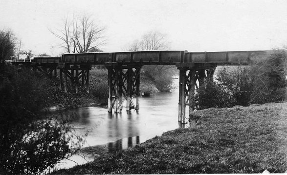 The Colonel Stephens structure, which was built in Edwardian times. [36]
The Colonel Stephens Society again: [36]
“The new crossing was again a simple structure and now consisted of 8 openings, with 2 centre spans of about 37’0” over the river, 2 land spans one on each side of 37’0” and 27’ 0” respectively, and 4 flood openings, 2 on each side each of about 20’0″ span. The 2 land spans and 2 river spans consisted of plate main girders and cross girders, the flood openings being of 2, 12” x 12” timbers on top of one another. Opening for mineral traffic with the branch on 21st February 1912 it may have looked spindly but it proved cheap and serviceable. Something in excess of 1 ¼ million tons of roadstone passed over it uneventfully in the next 25 years or so.
By 1939 however the S&MLR was in a terminal state with no passenger services, little general goods and only one serviceable locomotive. If the enterprise was to have any future it could only be rescued by an upturn in the Criggion roadstone traffic. And the quarry was turning to lorries for all its local needs. Of the average of 61,000 tons produced, 35,000 was for local consumption of which only 2,700 went by rail ,with 17,000 rail borne to the wider world. This was not enough but it was the only thing keeping the line going and the River Severn was about to strike again.
Extraordinarily cold nights followed by a thaw in January 1940 brought disaster: The beginning of January was mainly dry and very cold with frosty nights.
On the 20th, the early morning temperature was 15.8 ºF (- 9°C) and the temperature during the day only reached 27.68 ºF (- 2.4°C). The next day, a very cold night over most of the country, minima were between Minus 2.2 ºF (- 19°C) and minus 7.6 ºF (-21°C) in many places, including Ambleside (Cumbria), Canterbury (Kent) and Hereford. At Rhayader on the Severn’s sister river, the Wye, the temperature fell below minus 9.4 ºF (-23°C). After a brief milder interlude, persistent rain, much of it freezing, gave nearly 1.1 inches (28mm) on the 27th. This released ice flows into the River Severn in spate and these pressed against the piles of the bridge, which was so damaged on the 27th that all Criggion branch traffic ceased.”
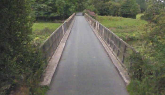
War time repairs were poor and the bridge was again in real trouble after the end of the Second World War. the bridge was assessed and it was determined that repair was not feasible and replacement was required. The S&MR could not finance the work but by July 1947 they persuaded the Ministry of Transport not only to accord the replacement of the bridge high priority at a time of material shortages but to loan the company the cash to do it! By this time, of course, the GWR knew that the newly nationalised railways would have to pay the bill. 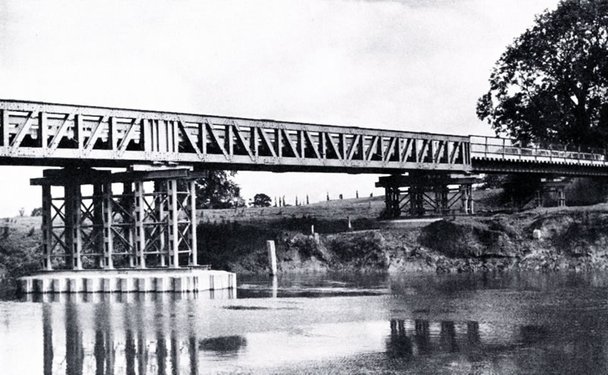 The new structure built in 1948. [36]
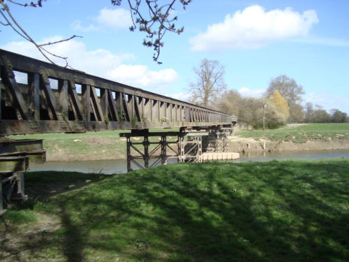 Another slightly more comtemporary view of the bridge. [37]
After closure of the railway in 1960, the bridge was handed to the local authority and it now serves as a road bridge. The satellite image above clearly shows the old route of the railway and the use made of both the old railway formation and Melverley Bridge by the 1962 road improvement.
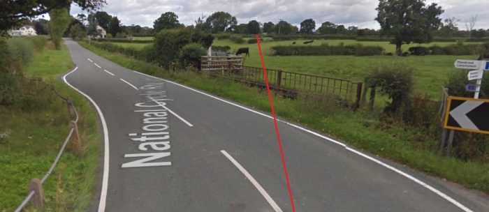 The point at which the road joins the route of the old railway.
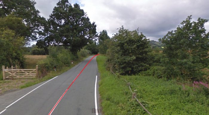
 Melverley Bridge in 2010!
 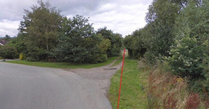 Road and railway route diverge. The red line shows the railway formation heading westwards towards Criggion.
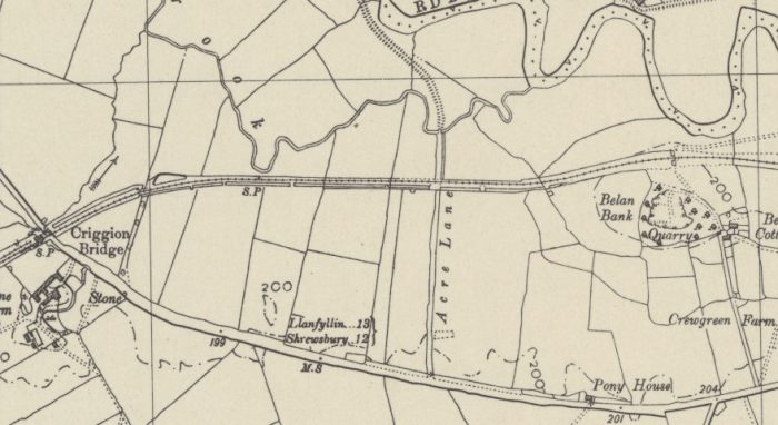 The next significant point on the line is Criggion Bridge which can be seen to the left of this map extract. At this point the old railway crossed the B4393 at a level-crossing. There was a small halt and a siding. to the West of the road.
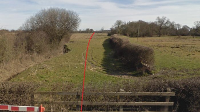 Looking back towards Melverley along the route of the line.
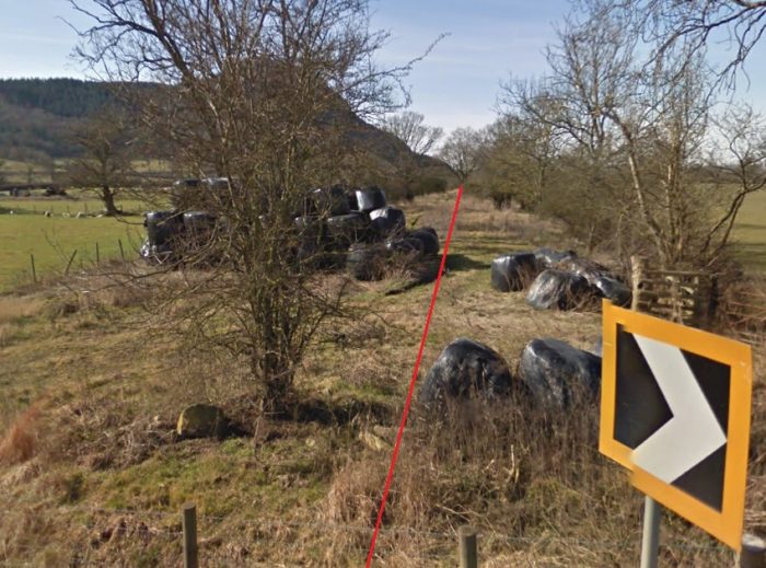 Looking forward along the line to Criggion.
 It is then only a short distance to the terminus in Criggion Village. That can be seen to the bottom left of this extract.
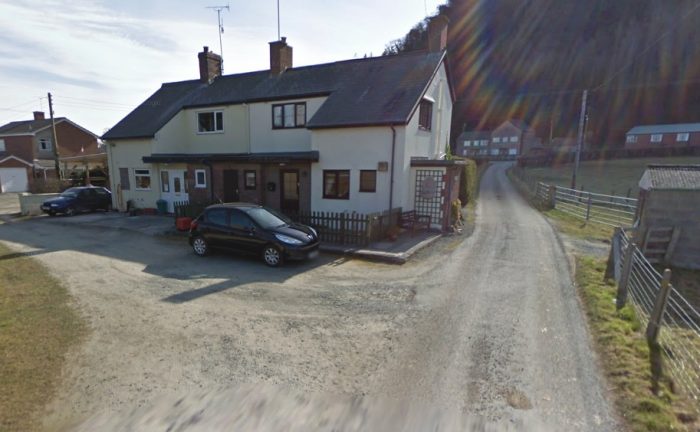
 The picture above is taken from the North and shows Criggion Station location. The line originally crossed the narrow lane behind the what was the station building and continued into the brickworks and quarry to the West, as shown in the map extract below. The station opened in 1872 and closed in 1932. The brick-built station house has been enlarged and extended and now forms two private residences as shown above. [39] The station is shown in the monochrome image above when in use in the 1920s. [15] The picture immediately below was taken, probably at a similar time. [40] Both of these pictures fail to show the station house which was on the north side of the line. It is just picked up in the top left of the second image below and showen effectively on bthe picture below that.
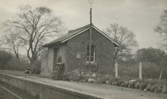
 Criggion station dated 5th August 1935 showing a Ford Railcar set at the platform on a summer excursion from Kinnerley, (c) Roger Carpenter. [15]
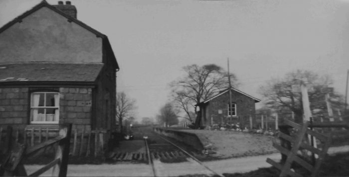 Criggion Station in 1958. [41: p57]
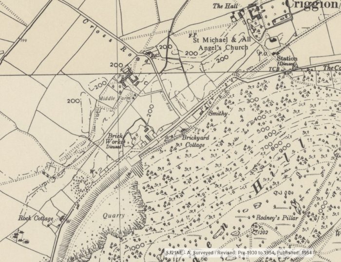
 This OS Map extract shows the brickyard and quarry at Criggion in 1954.
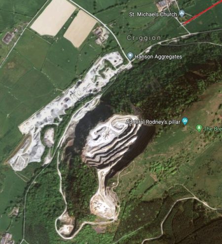
The satellite image sows the same location in the 21st century (2010). The quarrying operations appear to have expanded significantly. A large part of the hill has gone!
References
- https://www.google.com/mymaps/viewer?mid=1BIShmepoYEAsSHxhhLvHt7WzoOU&hl=en_GB, accessed on 13th May 2019.
- https://en.wikipedia.org/wiki/Shropshire_and_Montgomeryshire_Railway, accessed on 13th May 2019.
- https://en.wikipedia.org/wiki/Potteries,_Shrewsbury_and_North_Wales_Railway, accessed on 13th May 2019.
- https://spellerweb.net/rhindex/UKRH/GreatWestern/Narrowgauge/Potts.html, accessed on 13th May 2019.
- https://www.gracesguide.co.uk/Potteries,_Shrewsbury_and_North_Wales_Railway, accessed on 13th May 2019.
- http://www.bbc.co.uk/shropshire/content/articles/2008/10/08/potts_line_railway_feature.shtml, accessed on 13th May 2019.
- https://www.geograph.org.uk/photo/1732941, accessed on 13th May 2019.
- http://www.npemap.org.uk/tiles/map.html#347,311,1, accessed on 13th May 2019.
- https://shrewsburyrailwayheritage.com/abbey-station-and-its-environs-in-regular-use, accessed on 13th May 2019.
- https://www.shropshirestar.com/news/transport/2013/05/17/railway-buffs-to-get-glimpse-of-the-past-at-abbey-station, accessed on 13th May 2019.
- https://en.wikipedia.org/wiki/Abbey_Foregate_railway_station, accessed on 13th May 2019.
- https://en.wikipedia.org/wiki/Shrewsbury_and_Birmingham_Railway, accessed on 13th May 2019.
- https://maps.nls.uk, accessed on 13th May 2019. All these 1954 maps are taken from the National Library of Scotland Website.
- http://shropshirehistory.com/railways/stations.htm, accessed on 14th May 2019.
- http://www.oswestry-borderland-heritage.co.uk/?page=115, accessed on 14th May 2019.
- https://www.ebay.co.uk/itm/SHROPSHIRE-MEOLE-BRACE-RAILWAY-STATION-/362556514411, accessed on 14th May 2019.
- https://www.geograph.org.uk/photo/5049743, accessed on 14th May 2019.
- http://colonelstephenssociety.co.uk/the%20colonels%20railways/shropshire%20%26%20montgomeryshire%20light%20railway/index.html, accessed on 15th May 2019.
- http://lightmoor.co.uk/books/the-shropshire-montgomeryshire-light-railway/L9549, accessed on 15th May 2019.
- https://picclick.co.uk/Vintage-Rppc-View-Of-Ford-Crossgates-Railway-173387577752.html, accessed on 15th May 2019.
- https://www.facebook.com/sketchupdzine/photos/ms.c.eJw1ztkJRDEMQ9GOBu~_S~_m9scJL3ebgYOSObVHi3DP7LyFYARYW5rlNVlMviumCMaO~;XG7m2nuuZdWme4Tj2dw~;sHl1vD9J2pl1zuN3U1~;LZDs~;n5P6TzWead0M8fczctgfnOXF6fIZOdxx3FRguZ1y3Z5EN5h~;ukzp9.bps.a.323588904892406/323592774892019/?type=3&theater, accessed on 15th May 2019.
- https://www.geograph.org.uk/photo/340064, accessed on 15th May 2019.
- Handbook to the Shropshire and Montgomeryshire Railway, Livesey Ltd, Shrewsbury.
- https://chasewaterstuff.wordpress.com/2010/10/13/the-shropshire-montgomery-light-railway, accessed on 16th May 2019.
- http://colonelstephenssociety.co.uk/the%20colonels%20railways/shropshire%20%26%20montgomeryshire%20light%20railway/shropshire%20%26%20m, accessed on 16th May 2019.
- https://www.facebook.com/groups/165646463524643, accessed on 14th May 2019.
- https://en.wikipedia.org/wiki/Kinnerley_Junction_railway_station, accessed on 16th May 2019.
- hropshire%colonelstephenssociety.co.uk/the%20colonels%20railways/s20&%20montgomeryshire%20light%20railway/shropshire%20&%20montgomeryshire%20light%20railway%20photo%20gallery.html, accessed on 16th May 2019.
- https://en.wikipedia.org/wiki/Llanymynech_railway_station, accessed on 17th May 2019.
- https://en.wikipedia.org/wiki/Blodwell_Junction_railway_station, accessed on 17th May 2019.
- http://www.nantmawrvisitorcentre.co.uk/tanat-valley-light-railway, accessed on 17th May 2019.
- http://www.oswestry-borderland-heritage.co.uk/?page=133, accessed on 17th May 2019.
- http://www.disused-stations.org.uk/l/llanymynech, accessed on 17th May 2019.
- http://colonelstephenssociety.co.uk/the%20colonels%20railways/shropshire%20&%20montgomeryshire%20light%20railway/shropshire%20&%20montgomeryshire%20light%20railway%20-%20kinnerly%20to%20criggion-8.html, accessed on 17th May 2019.
- https://www.tate.org.uk/art/archive/items/tga-8728-1-31-85/piper-photograph-of-a-railway-line-near-melverley-shropshire, accessed on 17th May 2019.
- http://colonelstephenssociety.co.uk/shropshire%20ww1/melverley%20bridge.html, accessed on 17th May 2019.
- http://shropshirerailways.photo-bikes.com/shrewsbury%20to%20llanymynech.htm, accessed on 17th May 2019.
- http://www.tate.org.uk/art/archive/TGA-8728-1-31-85-1, accessed on 17th May 2019.
- https://en.wikipedia.org/wiki/Criggion_railway_station, accessed on 18th May 2019.
- https://www.ebay.co.uk/itm/Railway-Wales-Montgomeryshire-CRIGGION-Station-1951-Photograph-/161909837293, accessed on 18th May 2019.
- Peter Johnson; An Illustrated History of the Shropshire and Montgomeryshire Light Railway; OPC (Ian Allan), Hersham, 2008.

Dear Roger
Thanks for a fascinating page about a interesting railway, but could I clarify a couple of your photo captions please?
Ref 18, which you have described as ‘ex LSWR or LNWR,’ is definitely an ex LSWR ‘Ilfracombe Goods.’
Ref 19 which you have also described as ‘ex LSWR or LNWR,’ is actually ex GWR ‘Deans Goods’ as requistioned by the War Dept and carrying its WD number. Given that the water tower in the background appears to be the original S&MLR one, I would guess that photo was taken in the early days of MOD control.
Thanks & Kind Regards
Paul Moxham
Thank you. I will adjust the text of the blog.☺️
Dear Roger
Fascinating article on a very interesting line, but could I just clarify a coupe of the pictures you have used?
Ref 18 – You have said this is ‘Ex LSWR or LNWR engine.’ It is definitely an ex LSWR ‘Ilfracombe Goods.’
Ref 19 You have said this is ex LSWR or LNWR. It is actually an ex GWR ‘Deans Goods,’ as requistioned by the army, running as WD 190. Given that appears to be the original water tower in the background, I would guess that photo was taken in early MOD days.
Thanks & kind regards
Paul Moxham
Hi Paul, that is really helpful. Thank you. I will adjust the text of the blog.☺️
Looking forward to the rest of this, Roger. I have spent a fair amount of time at Nesscliff training area and I have lightly looked into its short life as a an ammo depot. The camp is a very well preserved example of a national service era site and the explosive store houses (ESH) are also an interesting selection of designs. I’ve not visit the other sub depots such as Ford, etc, but they are obvious on aerial photography and maps.
One point worth a mention is that at the Shrewsbury end there was a link made to the GWR Shrewsbury to Birmingham line which existed in early Potts days, but I gather fell into disuse fairly quickly. It left the main S&M line on the eastern side, some way south of the Abbey station, and headed roughly North, on the route used nowadays by the bypass.
Reblogged this on By the Mighty Mumford and commented:
I LOVE THIS KIND OF STUDY! BRANCHLINES…SHORT LINES…INDUSTRIAL AND HISTORICAL ARCHEOLOGY…<3
Hello Sir, A great blog, but one I will add my local 2-penneth too, if I may.
Llanymynech was of a very unique significance that isn’t immediately obvious. The River Vrnwy extends past here, to crew green, joins the severn and then continues to Shrewsbury. Up until the construction of the bridges at Shawardine and Melverley, Llanymynech was the only place to cross the river safely on that entire course.
See, the river bed is stones covering a water-soluble clay-like strata. underneath that, there is no perceivable bedrock from which to build. it’s generally very deep and or in a gully because of this, and if not, regularly treacherous and variable. It still is today, with sections previously deep navigations suddenly made shallow by new stones, or deep as an undermined section collapses.
Llanymynech’s limestone strata meant there was a narrow band where the river was actually able to be crossed, at the ford, roughly 100m upstream of the current A483 bridge. This bridge I might add, is off the strata, and is actually foundationless, being very carefully constructed on top of piles and piles of stone in the riverbed, as they couldn’t find a feasible bedrock there.
this was basically so until the Potts constructed it’s bridges. no other crossing of the river in the valley. Even the offa’s dyke wasn’t actually built across this section, simply because the river was an equally good natural barrier. It’s even mentionned in the Mabinogion as strategically useful. It meant that Llanymynech was an un-enviable and unavoidable point for crossing the upper severn valley in to the welsh heartlands. the identification and use of the limestone was a lucky side-venture. on the other front, it was also the visibly easier route around Llanymynech hill. unlike the llynclys route which survived, Llanymynech and careghofa was a comparatively unused corridor, and relatively problem free once past the canal at careghofa.
Also, (and more because I want Someone to have it down) 8108, an Ilfracombe Goods, was actually not a WD loco, and the WD introduced the Dean Goods, as surplus stock from WW1.
the Potteries line was only taken over by the WD, they didn’t own it. after they had done their own work to the line, they would “return it to the state they found it in” (something commented that was impossible, considering the decrepidation) It was, infact, still owned by the Shropshire Railway Company, and as such, this company was a WD puppet, as they didn’t own any rolling stock, or locomotives (they did, actually, own a range of 5-planks, which received SR livery) but to be a feasible company, they were given 8108. It only operated on Mondays (because that was the only day where the military would allow them to) and was used then by the civilian Shropshire Railways to do a weekly stone train, done every other day by the WD. Some of the divisions who trained on the PNWSR commented they learnt more about keeping a dead locomotive running from watching the civilian crew try to keep 8108 alive than from their own training! It’s been frequently missed or considered a Colonel Stephens oddity, having a loco that only ran Mondays for 30 years. the records of the volunteer 8108 crews and WD staff that we still have locally answered the mystery.
the PNWSR also had a fire-engine. this was scrapped (remarkably, all considered) in Swindon Dump, 1965. it was a horse-drawn carriage with a pump, and kept in a shed in kinnerly, with an agreement that the railway could borrow any two horses from anyone along the line to pull the fire-engine to put out a fire, and in recompense, the fire engine could be used to put out other fires. while the machine is long gone, some farms still have the agreement filed away with title deeds. it’s highly likely that the “shared allocation of red paint, for upkeep of the fire engine and equiptment” was re-used where it possibly shouldn’t.
Thank you for such a comprehensive contribution. As you may have seen there are a few other blogs in this series. Three relate to locos and rolling stock and one to the military involvement with the line. I’d appreciate any further comments that you have.
I particularly enjoyed your comments about the geology of the area and the bridging of the River Vyrnwy.
This week, I have had three days staying to the West of Llanymynech. We visited the old station site in Llanymynech and the Limeworks Heritage area, following the quarry and works railway routes and climbing the ‘English’ incline.
We also visited Llyn Vyrnwy in the rain on Thursday and Nantmwr on Friday. We searched out some of the bits of the Tamar Valley Light Railway that we could find on Friday. Perhaps a further blog will follow when time allows! ……
Good Morning. I have just read about the PSNWR fire engine and wondered if I could please place this text in Abbey Lines – the newsletter to members of the Shrewsbury Railway Heritage Trust. philip…philip davies, Chairman SRHT.
Hello Philip, you are welcomed me to use anything you want from the blog, an acknowledgment would be nice. Please bear in mind that I have made every effort to verify copyright on photos but sometimes without success. If you want to use a photo, you are best being sure for yourself that there are no copyright issues with the intended use.
My very best wishes
Roger
Good morning. Thank you for the remission. I will say image courtesy of Roger Farnworth and place the https link for people to visit your superb website and enjoy your research. I have permission from SV Blencowe to use an image of the dilapidated fire engine!-?which I will use in the next Abbey Lines I can post you a copy of you can provide your address- or email a smaller resolution pdf from the printer. By all means call me on 07762 215008 to discuss any Potts/S&M matters. Best wishes. Philip. Philip Davies
Thank you Philip. My email address is:
rogerfarnworth@aol.com
Best wishes
Roger
What a fascinating read. I knew little of the Shropshire & Montgomeryhire Railway before, so I thank you for the education.
Thank you.
Pingback: Holiday Reading! | Roger Farnworth
Dear Roger,
the National Railway Museum in York has a signalling diagram of Shrewsbury Abbot station on display in their signalling section. I’m kinda surprised you didn’t include it in this article, it would certainly complement it nicely.
Warm regards
– Christopher
Thanks Christopher. I was not aware of it
I happen to have a (rather low-quality) photo. You have mail!
Thank you.
Thank you for pointing it out.
Pingback: Light Railways in the UK – the early years after the 1896 Act – The Railway Magazine, August 1905. … | Roger Farnworth
Pingback: The Railway Magazine – January 1959 Volume 105 No. 693 | Roger Farnworth
Pingback: The Railway Magazine – January 1959 Volume 105 No. 693 | Roger Farnworth
Pingback: Rails up the Tanat Valley | Roger Farnworth