Nice to Monte-Carlo Branch Lines – La Ligne du Littoral et ses Antennes, First Generation Electric Tramways – (Chemins de Fer de Provence/Alpes-Maritimes No. 92) …
There were two branch lines worth noting between Nice and Monte Carlo: one from Pont-St. Jean to St. Jean-Cap Ferrat; one from Monaco-Gare to Monaco-Ville.
The tram route from Nice to Monte-Carlo is covered in an article which can be found by following this link:
This branch line was just under 2 km in length and ran between Pont-St. Jean at 27 m above sea-level to a terminus in St. Jean-Cap Ferrat at 3 m above sea-level.
Construction of the line started in June 1906 and it was open to traffic by 7th December 1907.
Along with the rest of the network it received a line number on 1st January 1923 – No. 22. It remained in service as a tramway until 9th March 1931, when it was replaced by a bus service. Rails were lifted by 20th June 1933.
A postcard photograph of Pont St. Jean with a tram approaching from the terminus on St. Jean Cap Ferrat, the photograph was shared on the Comte de Nice et son Histoire Facebook Group by Laurent Mannu on 20th April 2022. Travelling the opposite direction a tram would almost immediately stop at l’Octroi. [6]A very similar view in 2023. [Google Streetview, March 2023]
The line was single-track throughout with two intermediate passing places. It left the mainline between Nice and Monte-Carlo at Pont-St. Jean which sat at the point where the communes of Villefranche and Beaulieu shared a common border and at the point where the PLM line between Nice and Ventimille was bridged to provide access to the coastline. This was also close to the Octroi de St. Jean which, as we have noted elsewhere, was a building which housed municipal tax collectors and allowed them to control and tax goods transported by travellers.
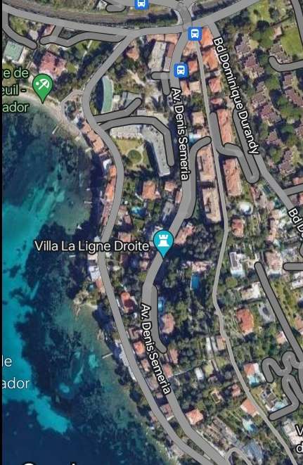
After crossing the railway line trams headed down Avenue Denis Semaria (M25) out onto the peninsula. The ‘new’ road, M125, can be seen heading West alongside the railway line. [Google Maps, November 2023]
The peninsula was an attractive area to build a home and the Tramway found its way through villas and gardens set among pine trees.
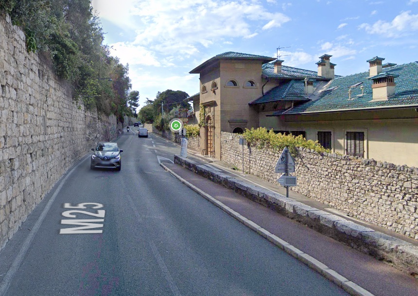
The M25 had to be rebuilt in to the West of and in parallel to its original route which was too narrow to accommodate both trams and other traffic.
The Gardens of Ephrussi de Rothschild sat above the tramroad to the East and Villa Andreae Nice to the West was to the right. [Google Streetview, April 2023]
After a passing-loop close to the chapel of St. François in the middle of the peninsula, the line descended eastwards to reach its terminus located at the port of St. Jean-Cap-Ferrat.
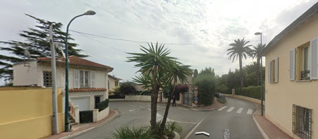
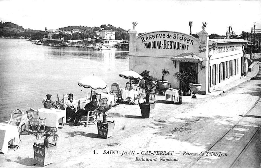
The tram route, as shown on a map of the area around Nice in 1914. [10]The tramway continued along Avenue Denis Semaria close to Jardinerie du Cap-Ferrat Marcarelli. [Google Maps, November 2023] The route continued to follow Avenue Denis Semaria and began to head down towards [Google Streetview, October 2022]The tramway turned away from one arm of Avenue Denis Semaria to head down to the Port along another arm of the same named road and following the route number M25. [Google Streetview, October 2022]The tramway continued round the curve on Avenue Denis Semaria. [Google Streetview, April 2023]Avenue Denis Semaria runs first due East and then turns round to the South as it approaches the Port and the location of the tramway terminus. [Google Maps, November 2023]Now heading due East on Avenue Denis Semaria (M25) and approaching the East coast of the peninsula. [Google Streetview, April 2023]A tram en-route from Pont-St. Jean down to the Port curving down along Avenue Denis Semaria not far from the Port. This image was shared on the Monaco4Ever Facebook Group on 1st September 2014 by Jean-Paul Bascoul. (Collection privée J-Paul Bascoul). [11]A very similar view in 2023. [Google Streetview, April 2023]Turning through 180°, this is the view along Avenue Denis Semaria towards the Port. [Google Streetview, April 2023]The bus terminus at Port-St. Jean. The tram terminus was a few hundred metres South , behind the camera. [Google Streetview, April 2023]The tram terminus was established at the port of St. Jean-Cap-Ferrat, Place du Centenaire, near the statue of the Fisherman, the work of Claude Vignon-Rouvier, wife of the politician Maurice Rouvier. Around 1910. The tram in the picture is made up of a powered car and a trailer. [4]A later view without a tram present. The buildings on the left have seen some significant work undertaken. The first is now a three-storey building and both that and the adjacent property have been extended towards the street. This image was shared on the Comte de Nice et son Histoire Facebook Group on 28th February 2022 by Alain Nissim. [5]A similar view in 2023 looking through the location of the tramway terminus to the North. [Google Streetview, April 2023]The cafe at the terminus of the tramway. The image was shared on the Comte de Nice et son Histoire Facebook Group by Alain Nissim on 18th February 2022. [9]A postcard view of Saint-Jean-Cap-Ferrat – Place du Centenaire – Tram Stop – Publisher: Giletta N°830. The photograph was taken sometime around 1920 and shows a powered car running round its trailer ready for the journey back to Pont-St. Jean. [4]A similar view in 2023 looking through the location of the tramway terminus to the South. [Google Streetview, April 2023]The Namuoma Restaurant at St. Jean-Cap Ferrat, with the tramway tracks visible to the bottom right of the photograph. This image was shared on the Comte de Nice et son Histoire Facebook Group by Alain Nissim on 16th August 2023. [7]Another view of the terminus. This image was shared on the Comte de Nice et son Histoire Facebook Group by Alain Nissim on 5th July 2021. [8]A similar view in 2023 looking through the location of the tramway terminus to the South. [Google Streetview, April 2023]
Monaco-Gare – Monaco-Ville
This line was marginally over 1 km in length. It low point was at Place d’Armes, just 19 metres above sea-level, its high point was at 59metres above sea-level at Place de la Visitation. It was single track over its entire length with no passing places . It also did not have passing loops at its two termini as it only used powered cars with no trailers.
Banaudo tells us that, “Starting from the PLM station square, it went down Avenue de la Gare for 101 m to Place d’Armes. This node in the Monegasque network formed a connection point with the TNL line towards Nice and the TM line towards Monte Carlo and St. Roman. Crossing this, the single track climbed by a long ramp of 77 mm/m the Avenue de la Porte-Neuve to the end of the Rocher dominating Fort Antoine, then a sharp bend brought the line back into the Avenue des Pins. The terminus sat at the entrance to the old town of Monaco, on the Place de la Visitation where the government palace stands.” [1: p54]
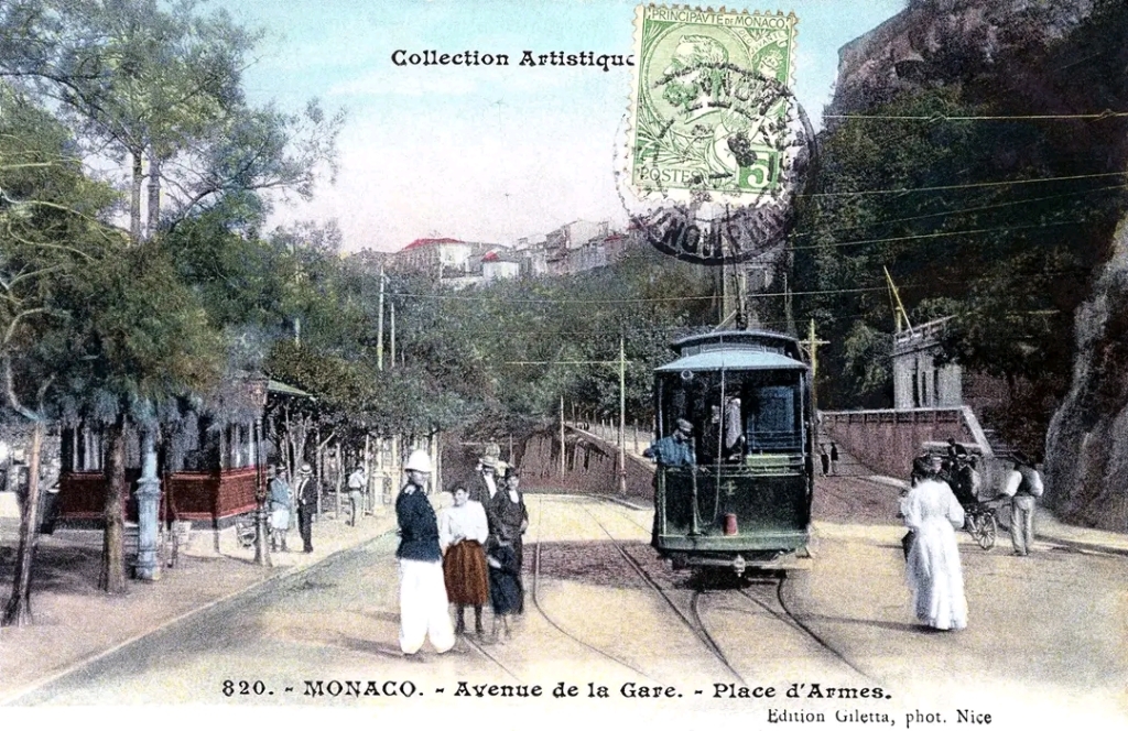
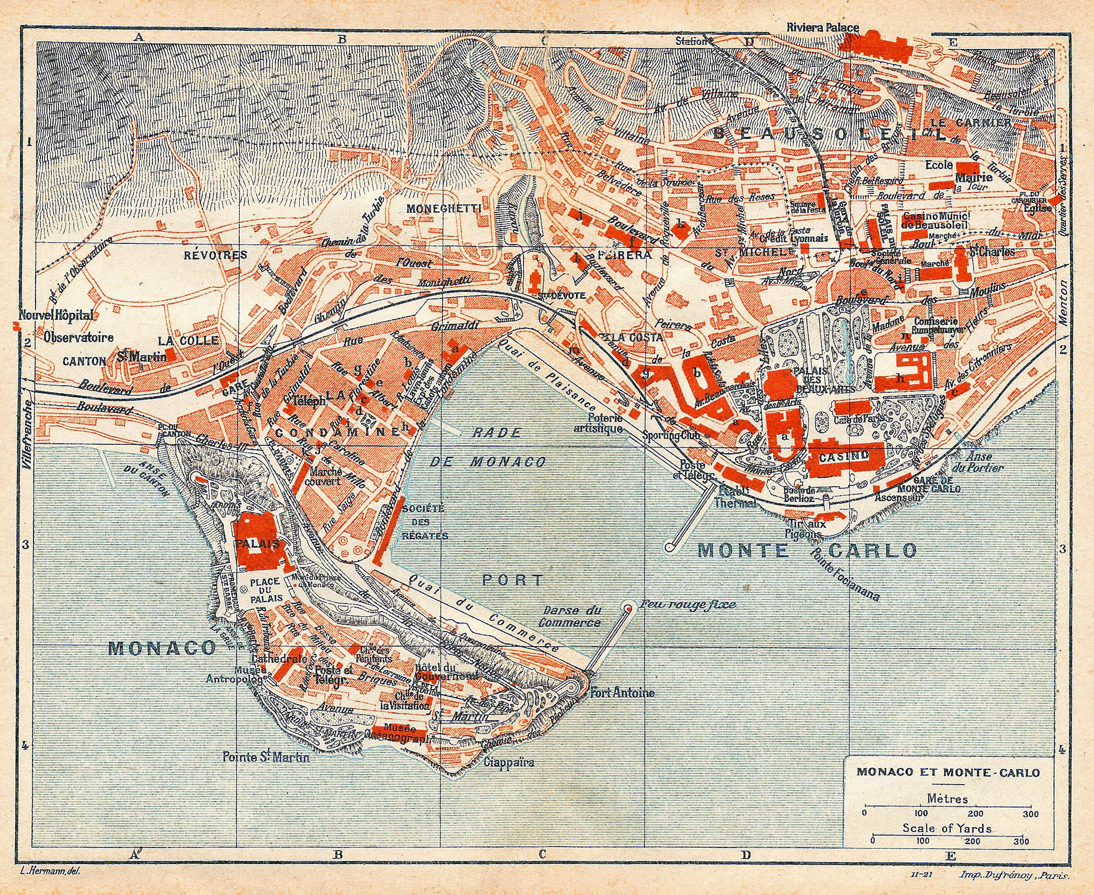
A plan of the different tram and train lines in Monaco and Monte-Carlo in the early 20th century. The article from which this image was taken was shared on the Monaco4Ever Facebook Group by Jean-Paul Bascoul on 17th May 2015. The line between the station and the Place de la Visitation runs left to right at the bottom of the map. [15]This map shows This branch line tramway ran from Monaco-Gare at the Northwest corner of this map extract through Place d’Armes and then along Avenue de la Porte Neuve before swinging sharply round to the West along Avenue des Pins, to terminate in Place de la Visitation. [16]Monaco Railway Station in the early 20th century. [19]Looking Northwest along Avenue Prince Pierre towards the location of Monaco Railway Station. [Google Streetview, July 2021]Looking along Avenue Prince Pierre into Place d’Armes. [Google Streetview, July 2022]The junction of Avenue de la Gare with Place d’Armes looking towards the railway station. This image was shared by Jean-Paul Bascoul on the Monaco4Ever Facebook Group on 23rd June 2017. (Collection privée J-Paul Bascoul). [13]A tram on Place d’Armes in the 1920s. This image was shared by Jean-Paul Bascoul on the Monaco4Ever Facebook Group on 20th June 2020. (Collection privée J-Paul Bascoul). [14]La Place d’Armes looking towards Monaco Railway Station which sits at the far end of Avenue de la Gare (now Avenue Prince Pierre). [12]A colourised postcard view of the junction between Avenue de la Gare (now Avenue Prince Pierre) and Place d’Armes. [17]Place d’Armes sat below the Palace of Monaco. It was the point at which trams from the railway station crossed the Nice to Monte-Carlo line and then headed up onto the rock. [16]The tramway up onto the Rock followed Avenue de la Porte Neuve. The tramway to the casino (and on to Menton) followed the parallel Avenue du Port. [Google Streetview, 2011]The tramway to the Casino and then on to Menton ran up the West side of the port. The tramway up onto the Rock via the Avenue de la Porte Neuve. [16]The tramway turned from the Avenue de la Porte Neuve into the Avenue des Pins and heads to its terminus at Place de la Visitation. [16]The tight curve of Avenue Saint-Martin leads round towards Avenue des Pins. [Google Streetview, 2011]The tramway followed Avenue des Pins heading off to the right leading towards Place de la Visitation. [Google Streetview, 2011]Place de la Visitation at the top of Avenue des Pins was the terminus of the tramway. [Google Streetview, 2011]
Images in this article accredited to Jean-Paul Bascoul come from his blog – Monaco4ever.blogspot.com.
References
José Banaudo; Nice au fil du Tram, Volume 2: Les Hommes, Les Techniques; Les Editions de Cabri, Breil-sur-Roya, France, 2005.
1 thoughts on “Nice to Monte-Carlo Branch Lines – La Ligne du Littoral et ses Antennes, First Generation Electric Tramways – (Chemins de Fer de Provence/Alpes-Maritimes No. 92) …”
mfaarup9
Amazing file of fascinating information. Thank you for putting all that information together, much appreciated. Michael


Amazing file of fascinating information. Thank you for putting all that information together, much appreciated. Michael