

Jose Banaudo writes,”As an extension of the Cannes Tramway route which linked Mandelieu, Cannes and Antibes, the TNL coastal line extended from Cap-d’Antibes to the Menton district of Garavan via Cagnes, Nice, Villefranche, Beaulieu , Monaco, Cap-Martin and Menton. These juxtaposed sections formed a continuous axis of 76 km of interurban tramway which served almost the entire coastline of the Alpes-Maritimes, from the Emite of the Var department to the Italian border.” [1: p35]
Jose Banaudo published a two volume set of books about the historic trams of Nice, “Nice au fil du Tram.” Articles based around the first of these two volumes can be found on this blog.
This is the third in a series looking at the second volume. The first two can be found on these links:
https://rogerfarnworth.com/2023/08/26/the-first -generation-electric-tramways-of-nice-again-four -of-the-urban-lines-chemins-de-fer-de-provence -alpes-maritimes-no-88/
The First Generation Electric Tramways of Nice again. Five more lines. (Chemins de Fer de Provence/Alpes-Maritimes No. 89) …
Nice – Cap d’Antibes
Of a total length of nearly 26.5 kilometres, the first 7.8 kilometres of this route (as far as St. Laurent-du-Var) were over the rails of Nice’s urban tram network. Cagnes was a further 4.8 kilometres along the coast and the length of the tracks between Cagnes and Cap-d’Antibes was 13.75 kilometres. The maximum gradient on the line was 49mm/metre with 2.22 kilometres on the level and 24.75 kilometres on a gradient, however shallow. The highest point on the route was on the length approaching Cap-d’Antibes.
Nice to Cagnes and Antibes services departed from Place Masséna, following Rue Masséna and Rue de France towards St. Augustin on the main East-West urban line. The double-track lines ended “beyond the stop serving the station called Le Var by the PLM then Nice-St.Augustin by SNCE Shortly after, a branch operated on race days served the Hippodrome … located on the left bank of the Var at the location occupied today by the postal sorting centre and the airport parking lot. The River Var was crossed on the bridge which carried both national road 7 and the PLM bridge, Marseille – Nice line.” [1: p35]


Trams stopped at the level crossing of the St. Laurent-du-Var station, at the point where the road leading to the centre of the town diverged from the RN7. “Beyond that, the track remained on the RN7 through the hamlet of Cros and then passed over the PLM line in the La Bégude district. The old town of Cagnes and its castle, built on a hill overlooking the modern districts, was seen while the River Cagne was crossed on an ancient donkey bridge. Beyond this structure, a station served the centre of the locality where a two-track shed served as a depot.” [1: p36]
Further west, the bridge over the River Malvan was followed by the PLM Cagnes Gare. This was the point at which lines of the TAM network to Venice and Grasse met with the TNL lines. Those two lines were opened in December 1911 but not connected to the TNL line until October 1917.


These different tram lines working in close proximity on the same site required special precautions, so as to avoid any accidental contact between the incompatible overhead lines of the two companies (550 V DC for the TNL and 6600 V single-phase AC for the TAM).

Leaving Cagnes through the St. Véran district, the TNL line ran on the shoulder of the NR7. It ran past the location of an Alpine hunters camp and then crossed the River Loup on a metal bridge. Sadly, I have not been able to find old views of the bridge over the Loup.

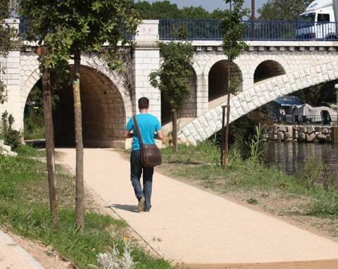
The line ran between the Vaugrenier pine forest and the PLM line, close to the sea and adjacent to the RN7. Jose Banaudo says that there were two stops with sidings (presumably passing loops) before the tramway crossed the River Brague on a shared bridge with the RN7. The Pont de la Brague, constructed close to the start of the 20th century, had three substantial arches. The spandrels of the centre-span had arched voids which relieved weight on the arch and allowed additional capacity for times when the river was in flood.


Attribution 2.0 Generic). [11]


The city of Antibes then came into view. First, trams passed Fort Carré, and then entered Antibes across a narrow road bridge over the PLM railway. The Pont d’Antibes had one metal span of 11m. Just beyond the bridge there was a short (118m) connection to ‘la gare PLM d’Antibes’ where there was a passing loop and shed.
There was a shuttle service between the Cap d’Antibes and the PLM station.

The tram in the picture above sits at the terminus of the short (0.3km) line from the railway station in Antibes which connected to the line from Nice.
After just over 0.2 km the line reached the southern end of Place Jean-Macé (then Place de la Victoire and today Général De Gaulle) where the TNL rails intersected with the tramway from Cannes (CTC) which had its terminus in Place Guynemer. Banaudo comments: “Originally, the tracks of the two companies only crossed, but a connection was established between them during the First World War to allow the circulation of direct freight trains between Nice and Cannes. Depending on the direction of traffic, the tram stopped on one side or the other of this intersection, near which a waiting room was set up on the ground floor of a building.” [1: p36]

From what is now Place General de Gaulle, trams ran along the Boulevard du Cap (today Albert Premier).


Trams ran in the road close to the beach at La Salis and then followed the Boulevard du Cap as it began to rise between villas and gardens which it served by a series of fixed and optional stops. Two passing loops were provided, one of which was at Chemin des Contrebandiers.

The Cap-d’Antibes terminus was established towards the south-west end of the peninsula, between the Grand Hôtel du Cap and the Graillon Tower.


This brings us to the westerly limit of the TNL. The CTC tramway to Cannes is a matter for another time.
To bring the trams to the Cap d’Antibes was a costly exercise. It was a steep, wooded promontory. It was also necessary to undertake costly work to widen existing roads. A generous loan on good repayment terms was agreed by the local authority.
The work included in the contract was the widening of local roads from 6.15m to 8m and the laying of the tram tracks.
Originally trams from Nice covered the full length of the line through Antibes and out onto the Cap d’Antibes. In the post-war years, the Nice and Cap-d’Antibes services were separated, the former running to Place Jean-Macé and the latter leaving from the PLM Station. [1: p38]
References
- Jose Banaudo; Nice au fil du Tram, Volume No. 2: Les Hommes, Les Techniques; Les Editions de Cabri, Breil-sur-Roya, France, 2005. This is a French language text.
- Not used.
- Not used.
- https://www.facebook.com/groups/ciccoli/permalink/2974470189465497/?app=fbl, accessed on 30th September 2023.
- https://www.facebook.com/groups/ciccoli/permalink/3136429316602916/?app=fbl, accessed on 30th September 2023.
- https://www.facebook.com/groups/ciccoli/permalink/3517639871815190/?app=fbl, accessed on 30th September 2023.
- https://saintlaurentduvar.fr/blog/la-gare-travers-l-histoire-un-quartier-en-mutations, accessed on 30th September 2023.
- https://www.cparama.com/forum/viewtopic.php?f=11&t=165, accessed on 30th September 2023.
- https://www.facebook.com/groups/ciccoli/permalink/3612075812371595/?app=fbl, accessed on 30th September 2023.
- https://www.nicematin.com/vie-locale/le-pont-de-la-brague-une-douloureuse-histoire-468926, accessed on 6th October 2023.
- https://www.flickr.com/photos/marsupilami92/13741672855, accessed on 6th October 2023.
- https://www.nicematin.com/faits-divers/les-berges-de-la-brague-s-offrent-une-nouvelle-jeunesse-364539, accessed on 6th October 2023.
- Not used.
- Not used.
- https://www.google.com/imgres?imgurl=https%3A%2F%2Fstatic01.nicematin.com%2Fmedia%2Fnpo%2F1440w%2F2016%2F11%2F34718603.jpg&tbnid=vZ5-SLb0NRZBNM&vet=1&imgrefurl=https%3A%2F%2Fwww.nicematin.com%2Fvie-locale%2Fewan-sur-la-piste-d-un-tramway-nomme-desir-96168&docid=E3doVhjrbZkPUM&w=1440&h=888&source=sh%2Fx%2Fim%2Fm4%2F2#imgrc=vZ5-SLb0NRZBNM, accessed on 30th September 2023.
- https://www.nicematin.com/vie-locale/ewan-sur-la-piste-d-un-tramway-nomme-desir-96168, accessed on 6th October 2023.
