
The Line of the West Clare Railway from Miltown-Malbay to Quilty
Before setting off on the next leg of this journey South along the Atlantic Coast of Co. Clare we take a quick look at the town of Miltown-Malbay which has only existed since about 1800 but grew rapidly: by 1821 it had a population of 600. During the Great Famine (1844 – 1848) many farmers were evicted by the unpopular landlord Moroney. In the years after the famine the (Protestant) Moroney family went on with rack renting and evictions. At one time the population had enough and started a boycott. The government did not like that and imprisoned all pub-owners and shopkeepers who refused to serve the family or their servant. So at the end of 1888 most pub-owners and shopkeepers were in jail! [9]
The Co. Clare Library says the following about the town:
Miltown Malbay or Sráid na Cathrach is at the heart of an ancient area known as Kilfarboy. Sráid na Cathrach translates into “The Street of the Fort”, deriving from the existence of an Iron Age fort (An Cathair) near the site of St. Josephs Parish Church. The earliest inhabitants of the area were likely found on the rising ground to the north and east of the present town, stretching from the fort to the monastic foundation in the townland of Kilfarboy. It is suggested by some that Miltown comes from the Irish “Meall-Bhaigh”, meaning a treacherous coast or bay. It could also have taken the name Malbay from either the tradition of the witch, Mal, being drowned in the bay, or that of the volcanic eruption which drowned 1,008 people and separated Mutton Island from the mainland in 804.
Miltown Malbay grew in part because of developments at nearby Spanish Point. Thomas Moroney built the Atlantic Hotel in the early nineteenth century and for a time it rejoiced in the title of the largest hotel in the British Isles. The seaside resort developed as a refuge for the aristocracy and some of the lodges can still be seen today although only a small portion of the hotel ruin remains.
Miltown Malbay once had five corn mills, of which the ruins of three can still be seen. In 1825 Terence MacMahon owned a corn mill and Mary MacMahon a tucking mill and the growing town was referred to as Poll a Mhuillin. This was later translated as the town of the mill or Milltown.
By 1837 Miltown Malbay contained 133 houses and 726 inhabitants. During the year of the abortive rising, 1867, the local resident magistrate wrote to the Under-Secretary at Dublin Castle because he was “seriously apprehensive of a Fenian outbreak” in the locality.
One of the greatest historical events ever witnessed in the town was the public address delivered by Charles Stewart Parnell in 1885. Although he was almost totally confining himself to parliamentary work at that stage of his career, Parnell agreed to come to Miltown due to his admiration for parish priest, Fr. Patrick White’s involvement in the land struggle. On January 26, 1885, Parnell came to Clare to turn the first sod for the West Clare Railway and later the same day came to Miltown for the meeting. Standing in front of the recently built parochial house, he addressed a crowd of over 20,000 and there were numerous bands in attendance. [10]
The town had a population of 575 according to the 2011 Census. Including the rural area around the town it counts about 1,600 inhabitants. [9]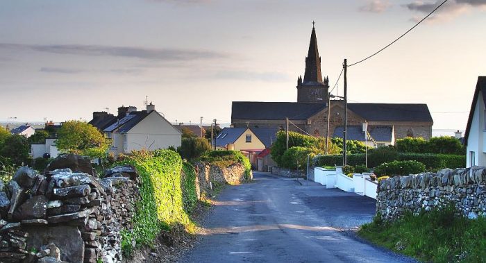 Miltown Church – St. Joseph’s [11]


 Miltown-Malbay regards itself as the home of traditional Irish music. [12][13][14]
The station building is sited to the Northwest of the town centre and is listed on the Irish National Inventory of Architectural Heritage as follows: “Detached former railway station complex, built 1857, comprising L-plan three-bay two-storey station master’s house with two-bay two-storey return, and four-bay single-storey station to right, having six-bay single-storey flat roof canopy over former platform. Now in use as guest house. Pitched slate roof with rendered chimneystacks. Rendered walls. Cast-iron columns to former platform. Timber sliding sash windows to former station. Replacement uPVC windows to house. Rough-cast rendered chamfered gate piers with wrought-iron gate to site. Former goods shed to site. Foundation stone of West Clare Railway laid by Charles Stewart Parnell to rear of this site.” [3] A Diesel Railcar at Mailtown-Malbay Station, seen from the North. Both the Good Shed and the Station building can be seen in this photograph. Both still stand and are now part of the complex of the guest house/hotel and apartments on the site [6]
 An Ennis-bound excursion train leaving Miltown Malbay on 16th August 1947, headed by Locomotive 11C. Presumably the wagon next to the engine was either vacuum braked or piped, but the reason for its use is unclear – unless to carry additional fuel for the locomotive. The first three coaches are West Clare ‘all thirds’, followed by two of the saloons. Notice the signal box. This was the last of the West Clare stations, equipped as a terminus complete with turntable and locomotive shed, and the last station with two platform faces, (c) Frank Jones. [16]
 Diesel Locomotive No. F503 at Miltown-Malbay Station in 1956. [4]
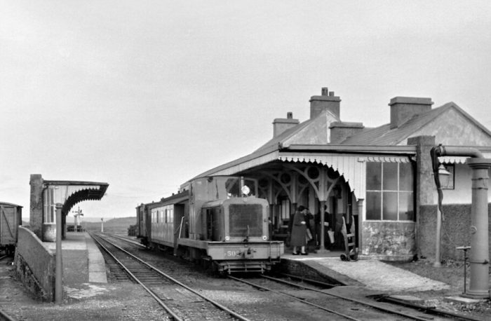 Loco No. F502 pulling a train for Kilrush in September 1960, (c) Roger Joanes. [8]
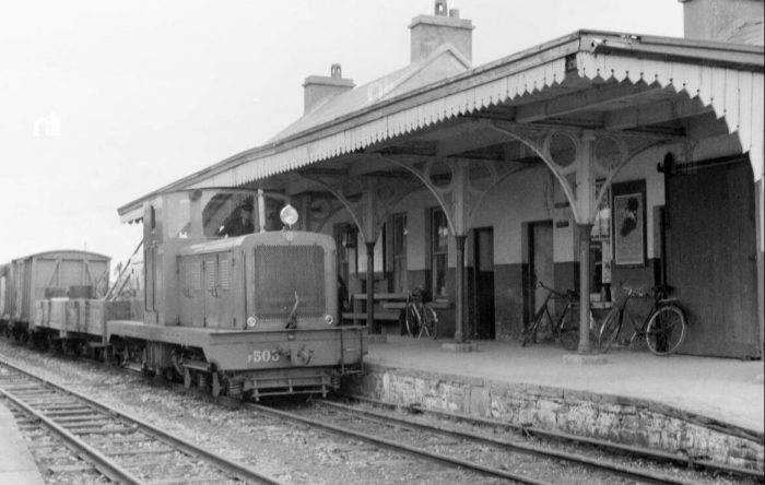 A pickup goods in the hands of Loco 503 at Miltown-Malbay in September 1956 (c) O’Dea Photograph Collection. [7]
 A view South towards the N67 from under the canopy of the extended and modernised station building. [5]

 The station layout in its heyday is shown above. [1]
Patrick Taylor describes the station as being “the last station to have both up and down platforms both of which were provided with verandahs. A loco shed, goods store, turntable and water tank (10,000 gals) were also situated here as Miltown-Malbay was the terminus of the West Clare Railway. A staff post with the station building on the down side, it possessed pretty extensive accommo-dation. The signal cabin and a cattle bank were situated on the down side. The water tank, goods store and engine shed were to the rear of the up platform. [15]
He goes on to say that: “On passing the down home signal the up road was connected to the right and a siding veered off to the left to run onto the rear of the down platform. Another siding ran off the up road to the rear of the platform, which served the goods store loading bank and water tower. There were two connecting spurs off this siding, one running on to the turntable and engine shed at the Lahinch side. The other running on to both the up and down road adjacent to the level crossing gates on the Quilty side. The up starting signal was situated beyond the up platform on the up side and a water column was at the end of the up platform on the Lahinch end . The down starting signal and a second water column at the end of the down platform faced towards Quilty.” [15]
The onward route of the line heading South is shown first on the satellite image above and then on the adjacent 1940s OS Map. The South Clare Railway commenced at this station, and ran past three level crossings inside the first half mile. The line passed to the West of the small town of Miitown-Malbay whose centre is shown on the OS Map above.
Taylor continues: “The Lahinch-Miltown Malbay main road was crossed at the station gates and after a minor road at Flag Road No.1, the Miltown-Quilty road was crossed at. Flag Road No.2 crossing. The Miltown-Malbay up home signal was situated on the upside a short distance on the Miltown side of Flag Road No.1. Two bridges, Sextons (No.53) and St. Joseph’s Well river bridge (No. 54) were in close proximity on the next stretch after crossing Braffa level crossing at 28.57 m.p.” [15]
For a bit more detail we turn to Edmund Lenihan. He says that a short piece of shallow cutting is all that remains of the line until it reaches the Flag Road No. 1 crossing which is just 300 yards West of the town’s main crossroads. [2] Looking North from the minor road which was crossed at Flag Road No. 1 Crossing along the route of the old railway line back to the location of the Station. The shallow embankment shows the location of the old railway with Miltown Malbay away to the right of the picture. The image below is taken looking South at the same location.
 The next crossing was Flag Road No. 2 Crossing and the line crossed Flag Road at this point.
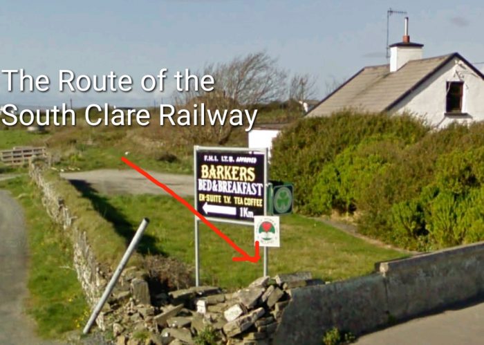 The location of the crossing is easily established as there is a different form of boundary wall across the line. This view is taken from Flag Road and looks back towards Flag Road Crossing No. 1.
 Looking south from Flag Road the route of the line has been built over.
 We are now at the top of the adjacent 1940s OS Map. The line is shown all the way through to Quilty on this and the next two OS Maps. The line curves gradually from a southerly trajectory to a southwesterly direction before curving south again at Quilty. The same length of the line is shown below these OS Maps in a series of satellite images from Google Earth. These are interspersed with Google Streetview images and others where available.
Edmund Lenihan spends some pages describing this part of the route. First, after the Flag Road crossings the line drifts towards Mullagh Road. Lenihan encounters two bungalows built over the line of the railway. At that point, adjacent to Mullagh Road the line was in cutting, so to build the two bungalows the cutting had to be filled. Prior to the construction of the two bungalows the cutting must have been immeidate ly adjacent to the road verge. [17]


The adjacent satellite image shows the route of the line tending towards Mullagh Road.
The next two satellite pictures show the two bungalows mentioned above. In these images, taken in around 2015, it appears that much of the railway cutting has been infilled. There are lengths close to the bungalows, both North and South of them where the cutting still appears to exist. In between the satellite images are pictures taken from Mullagh Road which show the line drifting towards the road from the North and then drifting away again to the South.
The photographs taken from Mullagh Road have the rough path of the railway line shown in red.
In the first, Miltown Malbay can be seen in the right-distance. The remaining three form a straightforward sequence with the last shown the route of the railway moving away from the road. The satellite image which folows these four oictures shows the route of the old railway from above.


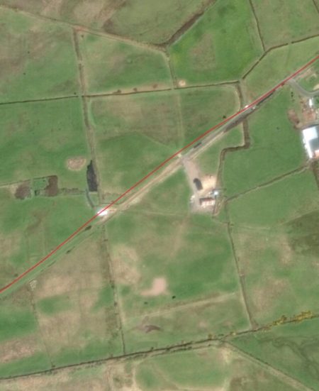
 As we travel on towards Quilty, we note that the route of the line now runs across open fields. On the ground there ois little trace of the line. The satellite images keep us on track.
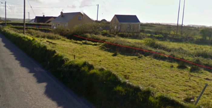
We cross a minor road at-grade. This was a gated crossing and the crossings keeper’s cottage remains in the 21st century. It is approachingvas we leave the adjacent satellite image and shows up clearly at the top of the next satellite image.
In between the two are Google Streetview pictures of the crossing and its immediate environment. A view from the East looking along the minor road. The old railway approached on the alignment shown, travelling behind the crossing-keeper’s cottage.
 The cottage has been extended towards the alignment of the old railway.
 The crossing was on a very shallow angle. This view is also taken from the East. The gate posts can still be seen at the far side of the crossing.
 The line continued on towards Quilty. As it does so, we listen to Edmund Lenihan’s description of the route just a little further ahead along the old line. Clearly he did not have the benefit of satellite imagery.
“We could see Miltown power station ahead and Breaffa cottage to our right, but of the line there was no trace. We reached the road, and could have saved ourselves discomfort by merely walking to the crossing and continuing from there. But instead we started across the fields towards the river, gradually correcting our line of progress as we went. We had an easier passage than we deserved, there being no more than muck and high ditches in our way, and even these we forgot as soon as we saw the Glendine River. Swirling, looping in sharp turns and little pools, it rattles along in its narrow gorge as if shepherding stones downstream to its meeting with the Annagh River. Our crossing point, Sexton’s Bridge, was intact, but since here were no parapets we hurried over it like men expecting that it might fall at any moment and with only the briefest glance of acknowledgment to the stream gushing underneath. Already, our sights were on a scene more imposing. Here, from a large valley towards which the Glendine cascades, rears a high, ivy-draped road-bridge of one main arch, with others flanking, while nearby, in the lee of Aillateriff heights, a group of mill-like buildings nestles. Over all, the power station stood out like a beacon, white against the sky. Without ever looking to the map we knew that this was Stackpoole’s Bridge and Poulawillin Mills. A few minutes’ walk and we were at Annagh No. 1 crossing, 28.75 miles from Ennis.” [18]
 The crossing-keeper’s cottage from Annagh No. 1 Crossing is shown above in 21st century and in the adjacent image from the 1950s © IRRS. [19] The second image is taken from south of the crossing, the first from the single-lane road that the railway crossed.
 The railway continued South from Annagh No. 1 Crossing.
 A few hundred yards beyond the road-crossing the railway crossed the Annagh River again. The bridge can be seenninnthe top right of the adjacent photo.
To the West of the road-crossing the road crossed the Annagh River. It was from McMahon’s corn and woollen mills in the immediate vicinity of thst road bridge that “the village of Miltown took its name in the nineteenth century, and the name of the nearby townland, Poulawillin, still preserves this memory. The bridge, at least 40-feet high, bears the inscription `Built by John Stackpoole, Esq. July 1811′, and has withstood the years with dignity.” [19] Just to the West of the bridge is St. Joseph’s well, the site of regular pilgrimages.
Once the railway crossed the Annagh for the second time it entered the townlands of Annagh. Lenihan’s says: “There was much to admire in the way the river squirmed along in a semi-circle to a huge pool at the base of the embankment close to where the twenty-ninth milepost once stood. A fine place for fishing, without doubt, but extremely deep and dangerous-looking. The current has begun to eat into the foundations of the line, and already land slippage has occurred, leaving a sheer and frightening drop.” [20]
One thing which is a recurrent reality in Lenihan’s book is the swamp-like nature of much of the conditions underfoot and at other times, just how easy it was to loose the route of the line. This next passage from his book gives a good impression of so much of the walks he and his son undertook.
“Our troubles continued, the swamp developing into a small lake. But for the rushes at the edges of the line, we could have made no progress. We hopped along, from one to the next, a business that demanded total concentration. Then, in lightning contrast, when we squelched through a muddy gap we found ourselves faced with a huge levelled field.The line was being elusive again, and succeeded in hiding from us for most of the way to the next crossing cottage half a mile away.” [21]
The next crossing was Annagh No. 2 Crossing and was 29.5 miles from Ennis and appeared in the centre of the last satellite image above. It was opened as a halt in May 1952. The control of the line passed, at this point, out of the control of Miltown Station.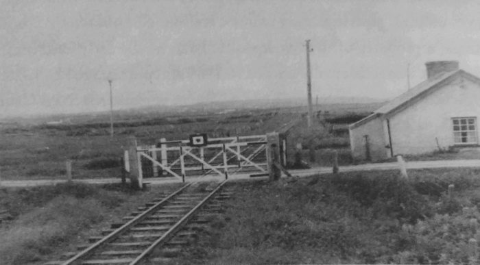 Annagh No. 2 Crossing in 1954, © IRRS. The picture is taken from south of the Crossing. [21]
 This new-build cottage is in approximately the same position as the old Crossing-Keeper’s Cottage at Annagh No. 2 Crossing.
 The line ahead.
Lenihan comments that from Annagh No. 2 Crossing, “there was no difficulty in getting to Emlagh crossing, for the way is quite clear and the surface dry. But there was little of interest to be seen. … At the triple boundary, Annagh, Caherrush and Emlagh, a handsome stone culvert lined with Liscannor flags still carries the boundary stream.” [21]
The crossing keeper’s cottage at Emlagh Crossing is still present in the early 21st century and can be seen easily in the satellite image above.
In the adjacent image we see the line from the Northeast arriving at Emlagh Crossing. The image below we look Southwest passed the Cottage.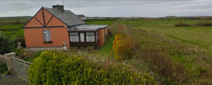
 We are now not so very far from Quilty. The village is in sight.
Lenihan continues his tale from the 1980s: “Ahead of us, an odd-looking fence appeared somewhat like a jump on a racecourse, surmounted as it was by a long post. When we reached it we found that it was no post, but one of the steel rails, only the second we had come upon in all the miles since leaving Ennis. A small stream once ran here, but it has been much altered enlarged by excavation, and the culvert demolished in the process. Two hundred yards farther on is another stream, this one the boundary with Quilty East. Here is a more substantial bridge, its stonework and girder facings still firmly intact.” [23]
Further ahead through muddy terrain, Lenihan encountered the stream dividing Quilty East from Quilty West where the bridge “had met the fate of so many others, leaving a 10-foot-wide, 6-foot-deep channel, newly gouged.” [23]
After that the final quarter of a mile towards Quilty was, for Lenihan, easy going. [23]
At Quilty a small estate of houses has been built over the route of the old railway, immediately before the station itself.
Quilty station building remains recognisable in the early 21st century. The station was built on a curve at the 31.5 mile post. It “was on the upside and consisted of a platform, small siding and goods store.” [24]
We will finish this short part of our journey here near the sea. It is worth noting that an anemometer was installed at Quilty because of the ferocious nature of the Atlantic storms which hit the coast here. It was installed in 1911. When the instrument indicated gales of over 60mph, only ballasted stock could be used and when a gale of 80mph was predicted, all traffic on the line was brought to a halt. It is on record that wind of 112mph were recorded in January 1927. The anemometer hut and pole are shown in the adjacent image, © IRRS. [24][25]
Edmund Lenihan expands on these bare facts: “On 3 March 1897 several carriages of the 10.30 a.m. passenger train from Kilrush were blown off the line between Kilmurry and here, and tumbled down an embankment.That there was no serious injury to any of the two dozen passengers was, as a newspaper report put it, ‘really marvellous’. Two years later, on 12 January 1899, at Quilty cross, the 8.30 a.m. train from Ennis was derailed in similar circumstances. Again, no one was seriously injured, but rather than wait for a tragedy to occur the company began to take precautions. A high earthen bank was built at the seaward side of the line south-west of the station, and in 1911 an anemometer was installed to warn of storms. Its high mast protruded from a little wooden hut on the up side a short distance from the goods’ shed (which stood at the end of the platform), but the instrument itself was in the station-house, where two differently toned bells awaited the onset of the wind. It became part of the stationmaster’s daily duties to take wind-speed readings. .... Ballast consisted of slabs of concrete under the carriage seats.” [26]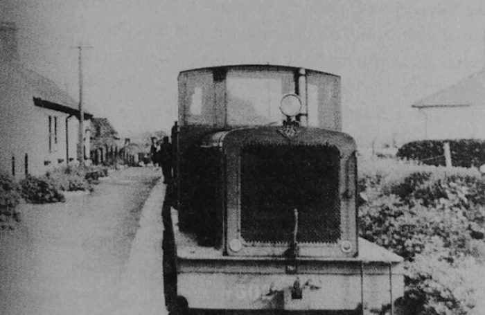 Diesel locomotive at Quilty Station just before closure, © IRRS. [27]
 Quilty Station just after closure. The picture was taken on 7th June 1961, © Roy Denison [27]
References
- Patrick Taylor; The West Clare Railway; Plateway Press, 1994, p48.
- Edmund Lenihan; In the Tracks if the West Clare Railway; Mercier Press, Dec. 2008, p168.
- http://www.buildingsofireland.ie/niah/search.jsp?type=record&county=CL®no=20300608, accessed on 20th April 2019.
- https://stationhousemiltownmalbay.wordpress.com/station-house-accommodation, accessed on 20th April 2019.
- https://www.facebook.com/StationHouseMiltownMalbay/photos/a.259048931094658/468777630121786, accessed on 20th April 2019.
- https://www.hydeparknow.uk/2017/07/13/stuck-in-miltown, accessed on 20th April 2019.
- https://twitter.com/theclareherald, accessed on 20th April 2019.
- https://www.flickr.com/photos/110691393@N07/11373840335, accessed on 19th April 2019.
- https://en.wikipedia.org/wiki/Milltown_Malbay, accessed on 20th April 2019.
- http://www.clarelibrary.ie/eolas/coclare/places/miltown_history.htm, accessed on 20th April 2019.
- https://www.westclare.net/miltown.htm, accessed on 20th April 2019.
- https://www.tripadvisor.com.sg/LocationPhotoDirectLink-g635643-i94980478-Miltown_Malbay_County_Clare.html, accessed on 20th April 2019.
- https://www.clareecho.ie/miltown-malbay-written-off-the-map, accessed on 20th April 2019.
- https://www.facebook.com/clareplaces/photos/a.1121180214559064/1121180307892388, accessed on 20th April 2019.
- Patrick Taylor; op.cit., p41.
- Ibid., p66.
- Edmund Lenihan; op.cit., p170.
- Ibid., p170-171.
- Ibid., p171.
- Ibid., p174-175.
- Ibid., p175-176.
- Ibid., p177.
- Ibid., p179.
- Patrick Taylor; op. cit., p41.
- Edmund Lenihan; op. cit., p180-181.
- Ibid., p181.
- Ibid., p179.

Hi, I really enjoyed reading and learning about the history. I am very much into Ancestry with DNA and have family from the Area. We visited last year and will visit again as Ireland is on our Agenda every year.
Often Nenagh, as this is where my Mum was from (A Moroney). They have an old railway. Do you have or intend to list any info from this area?
Warm Regards
Carrol 🙂
Hi, I am working slowly through different parts of Ireland and it’s 3ft gauge lines alongside other networks in the UK and around the world. Every blessing for 2021.
Thanks for all you great work
This is fascinating. My Grandmother was born in Miltown Malbay in 1901, her father Michael Griffin was the Postmaster. We stayed in Miltown Malbay in 2017 and look forward to going back. Thank you for sharing.