

“In 1905, two Plymothians, R. H. Payne, an estate agent and surveyor from Devonport, and Charles Cottier, (IDAS 1981) a solicitor and property developer, conducted a survey on the Southern moor (Dartmoor). … They commissioned R Hansford Worth to identify the location of any clay deposits which were sufficient to support a mining operation. He found large deposits around Redlake Brook which had previously been exposed by the earlier workings of tin streamers and peat cutters. The area was found to be at least 600 by 200 yards with a depth of 60 feet and was expected to be capable of producing a total of 2,250,000 tons at an annual extraction rate of 45,000 tons. This would realise an estimated value of £3,150,000.” [39]
Richard Hansford Worth (1868-1950) was born in Plymouth. He was a Civil Engineer whose knowledge of Dartmoor is best remembered for his antiquarian studies and as a local historian – see Worth’s Dartmoor, 1954.
“In 1910 the newly formed China Clay Corporation Ltd, with headquarters in Ivybridge, built a single track, three-foot gauge, railway running eight miles from the drying sheds at Cantrell to the pits at Redlake, with a rise of over a thousand feet. The railway opened on 11th September 1911 but it was not until the end of 1913 that the works were completed and ready to commence production.” [39]
It is worth noting here that the various sources associated with the Clay Workings at Redlake and Leftlake seem to use ‘Redlake’ and ‘Red Lake’ interchangeably, and similarly, ‘Leftlake’ and ‘Left Lake’. You will see this in evidence throughout this article.
I recently picked up a book by E.A. Wade, “The Redlake Tramway and China Clay Works,” published by Twelveheads Press, Truro, 2004, and thought that it would be good to have a closer look at the Tramway and the nearby, earlier, Zeal Tor Tramway. The Red Lake Tramway was a 3ft gauge line, the earlier Zeal Tor Tramway was of a wider gauge between 4ft 6in and 5ft. This article looks at the Red Lake Tramway. The Zeal Tor Tramway will be the subject of another article.
There was also a very short article in The Railway Magazine (Vol 98 No 614, June 1952) about the tramway, but I have been unable to find any further significant narrative in print. It is, however, mentioned by William Crossing in his ‘Guide To Dartmoor‘:
‘This track is really an old tramroad, over which peat was once conveyed to some naphtha works at Shipley, on the verge of Brent Moor. It has been disused for a very long time, but I can remember when the rails, which were of wood, bolted to blocks of granite, were to be seen in places. The buildings at Shipley still remain, having been put in a good state of repair by a china clay company, about the year 1872, but operations in connection with this venture did not long continue … The railway was formerly known as the Zeal Tor tram-road.” [4]
The Redlake Tramway ran from Red Lake across Dartmoor to Cantrell, near Bittaford, to the South. It was built to carry supplies and workers between Bittaford and the clay workings at Redlake, near the centre of the southern part of Dartmoor. It was built in 1911 to a 3 ft (914 mm) narrow gauge, and ran for a circuitous 8.3 miles (13.4 km). [5]
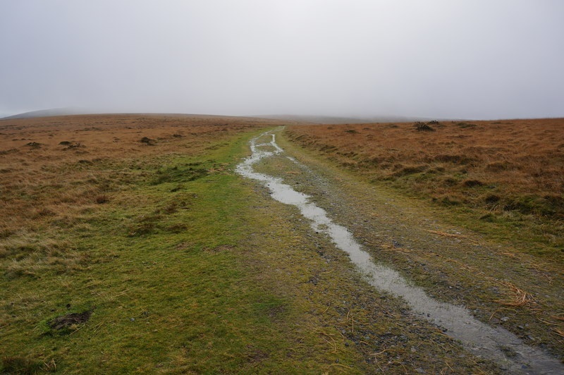
“The trackbed remains today. It can be followed from Bittaford Moor Gate providing access to several tors and hills such as Hangershell Rock, Sharp Tor, Piles Hill, Three Barrows, Eastern and Western White Barrows and Quickbeam Hill.” [5]
“The trackbed is lined at various points with marker posts, disused quarries and earthworks. Towards the top of the ascent are Leftlake and Redlake itself. Both are abandoned pits that have been flooded, creating lakes (the word “lake” in both names derives from the streams flowing through the areas, not the artificial lakes, which are recent features). There is a robust stone bridge at Leftlake, with a rudimentary name plaque engraved in mortar. At Redlake there are the remains of a demolished pumphouse, along with other ruins.” [5]


“At the southern end of the line remains the old bridge abutments of the track going over the incline which lowered wagons to give access to the standard gauge mainline, the trackbed of the incline, the base of the winding house, and at the line’s extremities the locomotive and carriage shed remains.” [5]


In addition to the Cantrell Works, the Company purchased Cantrell Farm which, in addition to the farm buildings, came with 64 acres of land. The farm purchase provided a series of buildings (stables and loft, cart house, wagon house, tool house, motor house, and root house) which facilitated activities over the whole works site. Close to the main works building there was also ‘Younghouse Cottage’ which acted as the works’ manager’s house. Further buildings were of timber and corrugated iron construction. [1: p45]
The Incline at Cantrell
Dartmoor Explorations website has a number of photographs of the incline and the area at the top of the incline. Their site can be found here. [10] (Further exploration along the length of the line is also available on the Dartmoor Explorations site, here. [11] The two webpages provide a superb set of photographs showing the route of the line from Cantrell to Red Lake.)


Wade describes the incline as being single-tracked and at a gradient of approximately 1 in 5, descending/ascending around 300ft. [1: p43]
“In the early part of the tramway’s history there was a signal at the top of the incline but this was later removed and replaced with warning notices. The Cantrell incline was operated once or twice a week, with four or five wagons being allowed on to the incline at once. The incline engine was operated by the locomotive driver. By 1928 the boiler for the incline engine had been condemned and needed a new firebox. It was kept down to a pressure of 50 p.s.i., at which it was only able to haul one wagon up the incline. The winding engine reversing lever was utilised as a brake. At the foot of the incline was a siding which ran on a loading bank (570 feet long by 13 feet 6 inches wide) between the mainline and a GWR transfer siding which was some 1,620 feet long and laid alongside the clay linhays. At the extreme western end of this siding there was a 22 feet long steel girder on a wooden framework, used for unloading machinery from the main line to the narrow gauge wagons. The loading bank was built on a level with the floor of the linhays and in it was built a weighbridge house. The sixty ton ‘Pooley’s Weigh-bridge’ was capable of weighing up to about 30 tons and was presumably set into the main line siding. The GWR siding was known as Cantrell Siding and the mainline company installed a signal box bearing the title, Redlake Siding Box.” [1: p43-44]

The abutments are all that remain of a bridge carrying a footpath over the incline. The abutments are of a more sturdy construction than would have been necessary for a footbridge but it not clear what this should be the case.


The tramway’s locomotive and carriage sheds sat about a quarter of a mile to the East of the incline. The main tramway route headed West from the incline before striking away North towards Red Lake. At the head of the incline, in front of the engine house, there were two lines, the main line and a short loop line. There was a wagon turntable provided on the loop line which made the connection to the incline. Wade tells us that each ascending and descending wagon had to be turned manually. [1: p44]

The Route of the Tramway
As we have already seen, the tramway and incline were set to a 3ft track gauge. The terminus of the line was at the engine shed and locos would travel from there passed the carriage shed and on towards the incline and the winding house. Just prior to the incline the stores building sat on the North side of the line. Wagons lifted up the incline would be turned by had on the wagon table and stored ready for a trip along the line.

The satellite image above has the trackwork superimposed on it by me. From this point on the route will be shown using railmaponline.com satellite imagery which is based on Google Maps satellite images. [13]


The locomotive would take the wagons West along the line passing to the South side of a quarry which had been used to provide ballast and construction stone for the line. All the while the tramway was rising steadily rather than just following the contours around Western Beacon. A relatively tight radius took the line round the western flank of Western Beacon. As it turned northward it crossed first the 800ft contour and then the 900ft contour.

The small engines would have been straining even under relatively light loads of predominantly empty wagons on the trip up to the main quarry workings.


The route of the old line, while generally moving Northwards was seeking the shallowest gradient possible and consequently curved with the contours of the land but continued rising relatively steeply. On the adjacent extract from the 25″ National Grid edition of the Ordnance Survey, the line switches back again and as it does so, rises through the 1000ft and 1025ft contours. [14]
It is necessary to show the line with a series of different OS map extracts as the route of the line crosses back and forth across the edges of two Ordnance Survey sheets. Whereas the satellite imagery used by railmaponline.com is not bound by map edges and can therefore be shown, over this length as one image.

Western Beacon summit is shown, towards the bottom-right of the adjacent railmaponline.com extract. The tramway route is shown in pink. The grey line running in from the bottom-left is the Two Moors Way which joins the old tramway route. [13]


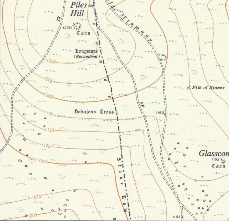

This next extract from the satellite imagery of railmaponline.com covers approximately the same area as the two OS Map extracts above. It shows the route of the Redlake Tramway continuing in a northerly direction with little of obvious note on the route. Grasscombe Ball and Piles Hill are not obvious at this magnification. [13]
The journey from the top of the incline has been over open moorland and it is worth noting that the old line was not fenced in any way. There is little to see in the immediate vicinity of the line other than rough grass.


The next extract from the 1954 25″ Ordnance Survey revision undertaken for the National Grid shows the old Tramway route crossing Ugborough Moor and continuing to climb to around 1375ft above sea-level. At around 1375ft the gradient flattens out and the old line passed through a natural defile to the West of Three Barrows. A shallow cutting was necessary at this point which can be seen at the top-left of the map extract.


This railmaponline.com extract on the right above covers the same area as the extract from the 1954 25″ Ordnance Survey revision alongside it.


The photo above was taken from a point a little to the North of the summit of Piles Hill, looking South-southeast along the old tramway with one of the stones shown on this small extract from the OS Explorer OL28. The picture was taken on 4th June 2006, © Derek Harper. It is included here under a Creative Commons Licence (CC BY-SA 2.0). [30]
Wade describes the route North from the western flank of Western Beacon as continuing “in a generally northerly direction, with detours to the west and east to follow and gradually ascend the contours of the hills, and passes below, and to the west of Hangershell Rock … Further north at Spurrell’s Cross (2 miles 63 chains) there was a passing loop and at Three Barrows (4 miles 44 chains) there was a short siding, entered from the Cantrell direction. A small shelter stood by the points. This siding served a further stone crusher for producing ballast. The concrete base and holding down bolts for it, can still be seen beside the track. Three Barrows is a prehistoric site where the ground was a mass of small blocks of stone with very little soil. This stone was excavated and was of such an even size that there was no need to screen it before it went to the stone breaker. Apart from some small cuttings and embankments, there are no really notable features on the line until the Leftlake clay pit is reached.” [1: p46-47]

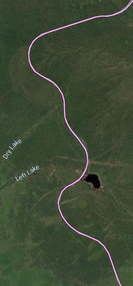
The two images above cover the next length of the tramway including Leftlake Clay Pit. That on the left is, again, an extract from the 1954 25″ Ordnance Survey revision undertaken for the National Grid. [17] That of the right is from railmaponline.com. [13]
“Apart from some small cuttings and embankments, there are no really notable features on the line until the Leftlake clay pit is reached. … At Leftlake the line passes over a stone and brick bridge … and between the pit on the eastern side … and the spoil tip on the western side. Above and to the South of the pit may be seen a small area of ruined concrete sand and mica drags which refined the Leftlake clay before it passed into the pipeline [to travel down to the Cantrell Works]. A passing loop or siding was put in at Leftlake when the pit was reopened in 1922.” [1: p47-48]

Leftlake Clay Pit
Dartmoor Explorations have produced an excellent webpage about the Leftlake clay workings which can be found here. [18]
There is a series of pictures on the different pages of that website covering the full length of the tramway. The pictures included here do not come from that site but rather, predominantly, from the Geograph website. [33]


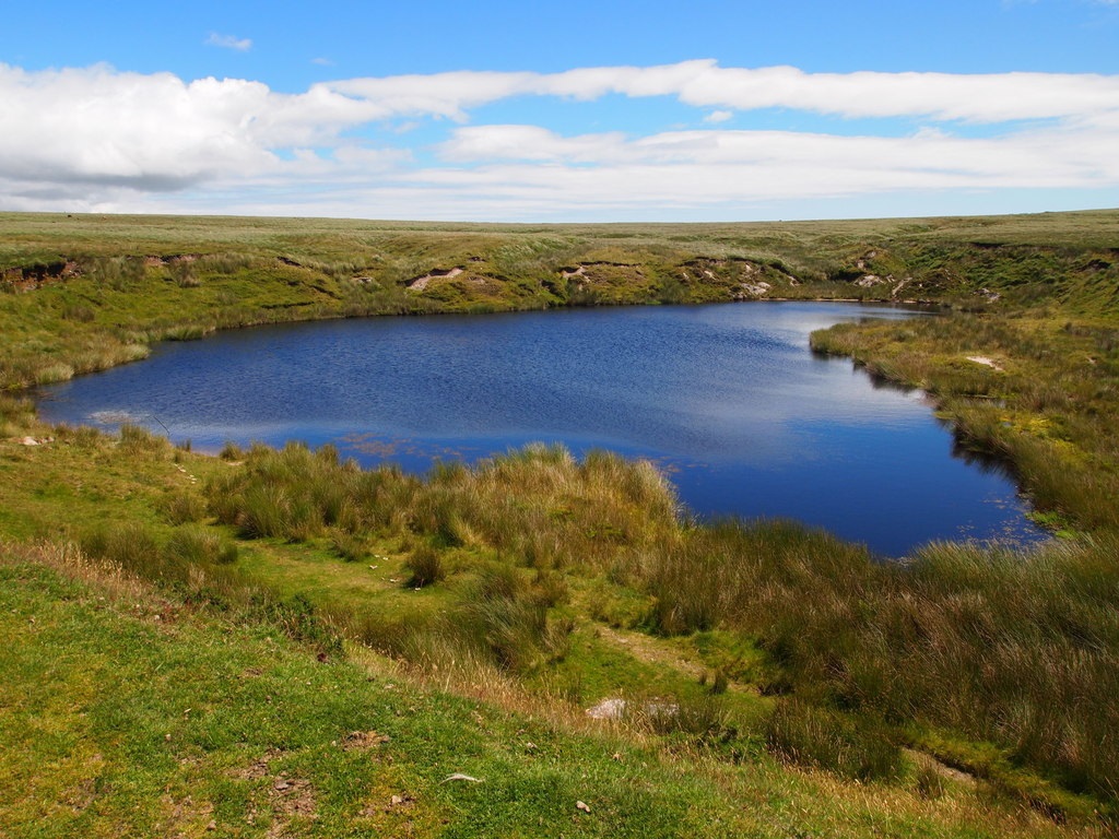


The Heritage Gateway records the site as No. MDV4234 – Left Lake China clay works, Harford and Ugborough Parishes and provides this description: “Left Lake, china clay workings. A large pit, now water-filled, several smaller pits and cuttings, and the brick bridge carrying the Redlake China Clay Railway. The clay ‘beds’ nearby are in Harford parish. The Harford parish boundary crosses the spoil heap on the west side of the rail track. The clay workings are of two periods: 1850-1858 and 1922-1932, but it is not clear which pits can be ascribed to each period, or whether the later workings went over the same ground as the earlier ones. The Blackwood Path passes through the workings, and it is possible that the horse-drawn wagons of the 1850’s used this track to Wrangaton.” [31]
Other sources suggest that the two worked areas were distinct with the earlier workings being to the West of the tramway and spoil heap. See, for example, the sketch on the Dartmoor Explorations webpage reproduced below. [18]

Among other details the Heritage Gateway notes that the site was worked “unsuccessfully for a short while in the 1850s, and later reopened between 1911 and 1932 by the China Clay Corporation. The works, which exploited the site of a former tin stream-works, comprises a 0.5 hectare clay pit, now water filled, a large area of substantial spoil heaps to the west of the pit (MDV28106), including a sky tip, ancillary buildings (MDV28104) and a processing works (MDV27892), all now ruined. An adit with a 30 metres-long finger dump is located 360 metres west of the pit beside Left Lake stream (MDV122904). The Redlake Railway (MDV3138), constructed in 1912, transects the site via a substantial embankment which has a stone underpass bridge to allow access from the pit. The double ceramic pipe (MDV5167) from Redlake, used to transport clay slurry to the drying floors at Cantrell, also runs through the site and clay from Left Lake was piped into it from the settling tanks, via an additional feeder pipe.” [31]
Left Lake clay pit operated with an incline similar to that at Red Lake (see further below) but on a much smaller scale. It bridged the Red Lake Tramway to gain access to the spoil heap.
The line North of Left Lake
Wade tells us that the tramway leaves the workings at Left Lake “in a north-westerly direction and then passes around a long semi-circular curve on a low embankment to face due east. From this point the Redlake spoil tip comes into view for the first time, some 50 chains to the north and looking no more than a molehill in the vast expanse of moorland. However, the track, which is now at its highest point (some 1,490 feet above sea level) still has nearly a mile to travel, on a slight downhill gradient, before reaching the works. It turns to the north (7 miles 50 chains [from the head of the incline at Cantrell]) and passes a ruined building which is the remains of the six roomed Red Lake Cottage, once the home of Captain and Mrs Bray. It crosses the path of the former Zeal Tor Tramway, from Shipley Bridge, at 7 miles 57 chains. Here it enters a cutting, the deepest on the line, turns to the north-west (7 miles 77 chains) and finally emerges at Redlake. The total length of the line was some 8 miles 17 chains.” [1: p49]


These two images show the remaining length of the Red Lake Tramway with the Red Lake clay workings shown towards the top of both images. The first (on the left) comes from the OS Sheet SX66NW from the 1954 revision undertaken for the National Grid. The second is approximately the same area as it appears on the satellite imagery provided by railmaponline.com [13]


Red Lake Workings
At Red Lake, we note that the spoil heap is much larger than that at Left Lake. Wade tells us that “the incline which took the wagons of waste from the pit to its peak is clearly discernable. This incline was not, of course, connected with the tramway proper and was of a different gauge. The large pit is now completely filled with crystal clear water and the banks drop away at an alarming angle. The original layout of Redlake was complex. … The lease extended to an area of some 1,300 acres but only a tiny proportion of this was ever worked; the pit itself eventually covering approximately 32 acres. In the main shaft, which was 130 feet deep, were fixed two pumps of the vertical single-acting, outside packed ram type; there being four rams, 13¼ inches in diameter with a six feet stroke. The cast iron column was 15 inches in diameter.” [1: p49-51]
“The stone built pumping engine and boiler house (with slate roof) contained two engines of the horizontal compound tandem condensing type, by Hawthorn, Davey and Co, with high and low pressure cylinders, of 18 inch and 36 inch bore by 48 inch stroke, and two 10 ton flywheels.” [1: p51]

The Heritage Gateway Website records the Red Lake China Clay works under record No. MDV107445.
“China clay working took place at Redlake between 1910 and 1932 and the remains of the site comprise the water filled pits, massive spoil heap, and ruined remains of buildings and some machinery, as well as the route of the railway that carried workers and supplies to the site.” [37]
The website includes a quotation from an Archaeological Survey of 2018 which covers the full length of the tramway and associated buildings before focussing on the site at Red Lake. ….
Redlake China Clay pits were active between 1910 and 1932, operated by the China Clay Corporation Ltd and later by the Ivybridge Clay Company. The extractive site and the processing works are at several different locations, all served by the Redlake Railway which runs from Cantrell at Bittaford, to the Redlake pits, a distance of 12.7 kilometres. The primary processing plant (MDV5159) was on Ugborough Moor, while the drying sheds and distribution facility was at Bittaford. Clay was transported between the two via a twin ceramic pipeline (MDV5167) running approximately parallel with the railway. The clay pit is located on flattish ground at the head of Red Lake, an eastern tributary of the River Erme, from which the name of the clay works was derived, and which had previously been heavily worked for tin using stream-working methods. The clay-working remains comprise a very deep pit, though this is now completely water filled with a surface area of 1.4 hectares. A large overburden heap (MDV122909) in the form of finger dumps is 120 metres south-west of the pit, where the waste was delivered via a tramway. The earthwork cutting through which the tramway passed survives though now disguised by rushes. The main, cone-shaped waste heap (MDV 26060) is adjacent to the north-east side of the pit. This was a sky tip of 20 metres high, which in later years of operation was fed by an inclined tramway leading directly from the bottom of the pit to the summit of the cone. The ridge on which the incline travelled survives running up the south-west arc of the heap. Evidence of flat-topped finger dumps on the south-east slope of the mound suggest that an earlier phase of dumping used horizontal trams to distribute the waste. Two shallow reservoirs (MDV 25059) are sited to the south-east of the sky tip covering an area totalling 0.5 hectares. These probably supplied water to the monitors to wash the clay out of the pit, as well as the boilers in the engine house. Both still retain water. The remains of several buildings survive as either stone foundations or demolished rubble. A number of timber-framed buildings … including a peat store, locomotive shed and others, have left no trace other than the levelled ground on which they once stood. The engine/boiler house (see MDV 24806) was the most substantial building at the clay works, constructed from stone, brick and re-enforced concrete. Remains of the winding house (see MDV122901) sit on the pit edge and occupied an area of approximately 9.7 metres by 7.6 metres. Of the range of buildings to the south, … fragments of only the two masonry structures survive (MDV122902), built from stone and brick and totally demolished, leaving a few short lengths of in-situ wall bases and a section of a chimney breast to the south. The northern of these was probably the Blacksmith’s shop which has the concrete base of an anvil with fixing studs in situ. The southernmost building at Redlake was the barracks (MDV25061). This was a rectangular, timber and corrugated iron structure built onto shuttered concrete foundation walls. Only the foundations survive, which have overall dimensions of 19.3 by 12.5 metres, standing to a maximum of 0.4 metres high. [38]


Wade goes on to comment on the spoil heap (sky tip) and the burden tip (where the overburden was dumped). …
“The spoil tip, adjoining the pit, was sited on a convenient area of granite, thus avoiding the waste of any clay bearing land. … The burden tip (where the overburden was dumped) was sited at the opposite side of the pit to the spoil tip and had temporary railway track laid on to it. There was about a mile of 14 lb and 18 lb per yard portable track at Redlake. Around the north side of the pit was dug a boundary leat which collected surface water from the moor and fed it into two artificial reservoirs which supplied the water for the monitors and feedwater for the boilers. This leat also prevented considerable quantities of water from entering the pit. The whole works were floodlit at night. The upper terminus of the tramway consisted of a long run-round loop adjacent to the engine shed (into which there was presumably a siding) and the line proper finally came to an end under the ‘sky tip’ incline; from which sand could be dropped into trucks. However, as has been stated, there was a great deal of portable track at Redlake and it is probable that the locomotives were frequently able to travel right around the perimeter of the pit.” [1: p51]
Locomotives and Rolling Stock on Red Lake Tramway
“The small line had a total of three locomotives in its 21-year lifetime. First delivered was ‘C.A. Hanson’, the locomotive having been named after the clay works owner. It was a 3 ft gauge version of a Kerr Stuart standard gauge Waterloo class, the smaller gauge being achieved simply by putting the wheels in between the frames instead of outside (Outside frames) – Apart from this it was a standard loco design.” [5]


“The second locomotive was ‘Dartmoor’, a Kerr Stuart Tattoo class loco. It was of standard Tattoo design, so no drawings exist of this exact loco, except for the cab which was different to offer greater protection considering Dartmoor’s harsh climate.” [5]
The ‘Tattoo’ Class Kerr Stuart Locos were 0-4-2T locos and a number have survived into preservation. ‘Dartmoor’ had a modified cab to cope with the harsh climate on Dartmoor. Three examples exist in the UK, all operational: ‘Stanhope’ (1917) on the Apedale Valley Light Railway; Talyllyn Railway No.4 ‘Edward Thomas’ (1921); and Corris Railway No.7 (2005); at least two survive out of service in Namtu, Burma at the Burma Mines Railway. The class was built with either outside frames (such as Stanhope) or inside frames (such as Edward Thomas). However, none of these remaining examples were built to 3ft gauge as ‘Dartmoor’ was. [53]


“The third loco was ‘Lady-Mallaby Deeley’, and 0-4-0 geared vertical boilered locomotive. Built by Atkinson Walker’s, it was the sister of the AW tractor provided to the Clogher Valley Railway, which was reputed to be unsuccessful, thus being converted to diesel. It survives to this day. Unlike the CVR tractor, the Redlake one was deemed highly successful and was the preferred loco at the time (C.A. Hanson having been scrapped in 1921).” [5]
“Both ‘Dartmoor’ and ‘Lady-Mallaby Deeley’ were scrapped on the line’s closure in 1932.” [5]
Wade writes, in an article on the Merioneth Railway Society website, [48] that “‘Lady Mallaby Deeley’ was the last locomotive to work on the Redlake Tramway. She was built by Atkinson-Walker Waggons Ltd of the. Frenchwood Works, Preston and was one of their Class A.3 steam tractors. This company, which was an amalgamation of Atkinson Waggons Ltd (who had absorbed the Leyland Steam Wagon Company of Chorley) and Walker Bros (Wigan) Ltd, produced no more than twenty-five locomotives between 1927 and 1931; the majority of which worked on industrial lines, in Britain and overseas. Walker Bros (Wigan) Ltd was founded in the 1870s as Walker, J Scarisbrick and Bros, the name being changed about 1880, and produced some twenty steam engines until about 1888; diesel passenger railcars being manufactured at a later date. However, the design of the Atkinson-Walker engines is attributed solely to Atkinsons, who were much better known for their steam road vehicles. All of these locomotives had vertical boilers within all enveloping bodywork, giving them the appearance of boxes on wheels. They were built in four classes with 0-4-0 or 0-6-0 wheel arrangements and either vertical or horizontal cylinders. The works numbers began at 101 and all were to standard gauge except numbers 111 (the Redlake engine) and 114, both of which were of 3ft gauge, and 105 – 108, which were all exported to Singapore and were probably of metre gauge.” [48]

“Number 111 was built early in 1928 and was delivered to the lvybridge China Clay Co Ltd in the same year, where she was named LADY MALLABY DEELEY after the proprietor’s wife. She, that is to say the locomotive, was of class A.3 (the 3 possibly indicating the gauge) and was of 0-4-0 wheel arrangement with a vertical water tube boiler, with a squared firebox, very like those fitted to the road vehicles. The boiler was made virtually in two pieces, which could be taken apart for internal cleaning, and was fired through a chute which had its opening in the footplate.” [48] It seems that the locomotive had a very short working life of around 4 years. It was sold in 1933, to Marple and Gillott of Sheffield, who appear to have been machinery merchants and scrap metal dealers and there is no further mention of it in historic records. [48]
Of, perhaps only incidental interest here, is the fact that sister locomotive No. 114 was delivered new to the Clogher Valley Railway in Ireland and was claimed to be a total failure. After lying out of use until 1932, it was fitted with a diesel engine by the County Donegal Railways. Named PHOENIX, it exists to this day in Northern Ireland. 114 was said by the makers to consume 10lbs of coal per mile (although it is unlikely that such a low figure was obtained in practice) and to have cost £950 when new in 1928. [48]


There were initially 3 bogie coaches. One bogie coach was later split it two 4 wheel coaches (one with 3 windows and one with 4), numbered 3 and 4. [49]
References
- E.A. Wade; The Redlake Tramway and China Clay Works, published by Twelveheads Press, Truro, 2004.
- Co-ordinates: 50.4857165, -3.9096677.
- Co-ordinates: 50.3943394, -3.8873118.
- William Crossing; Guide to Dartmoor; Forest Publishing; updated edition of 1912.
- https://en.wikipedia.org/wiki/Redlake_Tramway, accessed on 26th March 2023.
- Co-ordinates: 50.455172,-3.906567
- https://www.geograph.org.uk/photo/2023067, accessed on 26th March 2023.
- https://maps.nls.uk/view/101445595, accessed on 26th March 2023.
- https://maps.nls.uk/view/189248150, accessed on 26th March 2023.
- https://dartmoorexplorations.co.uk/3-red-lake-clay-workings-cantrell-processing-plant-the-incline-plane-clay-pipeline-and-the-locomotive-sheds, accessed on 26th March 2023.
- https://dartmoorexplorations.co.uk/red-lake-china-clay-workings-extraction, accessed on 3rd April 2023.
- https://www.geograph.org.uk/photo/1181257, accessed on 3rd April 2023.
- https://www.railmaponline.com/UKIEMap.php, accessed on 3rd April 2023.
- https://maps.nls.uk/view/189248141, accessed on 3rd April 2023.
- https://www.geograph.org.uk/photo/1260115, accessed on 3rd April 2023.
- https://maps.nls.uk/view/189248204, accessed on 4th April 2023.
- https://maps.nls.uk/view/189248195, accessed on 4th April 2023.
- https://dartmoorexplorations.co.uk/leftlake-clay-works, accessed on 4th April 2023.
- https://www.geograph.org.uk/photo/1051318, accessed on 5th April 2023.
- https://www.geograph.org.uk/photo/5038764, accessed on 5th April 2023.
- https://www.geograph.org.uk/photo/5038766, accessed on 5th April 2023.
- https://www.geograph.org.uk/photo/1088632, accessed on 5th April 2023.
- https://www.geograph.org.uk/photo/1088569, accessed on 5th April 2023.
- https://www.geograph.org.uk/photo/3959616, accessed on 5th April 2023.
- https://www.geograph.org.uk/photo/4295752, accessed on 5th April 2023.
- https://www.geograph.org.uk/photo/116649, accessed on 5th April 2023.
- https://www.geograph.org.uk/photo/4283893, accessed on 5th April 2023.
- https://www.geograph.org.uk/photo/4283840, accessed on 5th April 2023.
- https://www.geograph.org.uk/photo/2618037, accessed on 5th April 2023.
- https://www.geograph.org.uk/photo/2617982, accessed on 5th April 2023.
- https://www.heritagegateway.org.uk/gateway/Results_Single.aspx?uid=MDV4234&resourceID=104, accessed on 5th April 2023.
- https://www.geograph.org.uk/photo/1051283, accessed on 5th April 2023.
- https://www.geograph.org.uk, accessed on 5th April 2023.
- https://www.geograph.org.uk/photo/1130078, accessed on 5th April 2023.
- https://maps.nls.uk/view/189248189, accessed on 5th April 2023.
- https://maps.nls.uk/view/189248180, accessed on 5th April 2023.
- https://www.heritagegateway.org.uk/gateway/Results_Single.aspx?uid=MDV107445&resourceID=104, accessed on 7th April 2023.
- P. Newman; The Upper Erme Valley, Dartmoor National Park, Devon: An Archaeological Survey, Appendix 1 (Report – Survey). SDV362921, 2018.
- https://ivybridge-heritage.org/redlake-tramway, accessed on 7th April 2023.
- https://www.geograph.org.uk/photo/1485419, accessed on 7th April 2023.
- https://www.geograph.org.uk/photo/991002, accessed on 7th April 2023.
- https://www.geograph.org.uk/photo/3959605, accessed on 7th April 2023.
- https://www.geograph.org.uk/photo/3959576, accessed on 7th April 2023.
- https://www.geograph.org.uk/photo/1482801, accessed on 7th April 2023.
- https://www.geograph.org.uk/photo/990400, accessed on 7th April 2023.
- https://www.geograph.org.uk/photo/3959581, acessed on 7th April 2023.
- https://www.geograph.org.uk/photo/991012, accessed on 7th April 2023.
- http://www.merionethrailwaysociety.com/lady-m.html, accessed on 7th April 2023.
- http://www.rue-d-etropal.com/3D-printing/3d_printed-British-3ft-narrow-gauge.htm, accessed on 7th April 2023.
- https://ivybridge-heritage.org/redlake-tramway, accessed on 7th April 2023.
- https://www.irsociety.co.uk/Archives/5+6/KS_Wren.htm, accessed on 7th April 2023.
- https://www.shapeways.com/product/JCHYWCWWD/o-32-redlake-tramway-coach-3-4, accessed on 7th April 2023.
- https://en.m.wikipedia.org/wiki/Kerr,_Stuart_and_Company, accessed on 7th April 2023.

Hello Roger,
Thanks very much for posting this most interesting report. I was brought up in South Devon and have fond memories of my family once attempting to drive the route of the Redline Tramway in our old Triumph Herald. We got about three quarters of the way before the going got rough and we decided to turn back rather than risk the car’s springs. We were, however, within sight of the old tips at Redlake. One day I must go back and walk the route properly.
At the time it was against the law to take a car onto Dartmoor more than, I think, 15 yards off a highways. There was an indomitable lady, named Lady Sayer, who I think was in charge of a preservation society for Dartmoor, who was rumoured to go around taking the registration numbers of cars which transgressed this rule and passing them on for prosecution. My Mum was convinced she would pop up somewhere along the route and bag us!
This was in the late 1960s. The route hasn’t changed much since then and, other than the trackbed and the remains of the buildings which you document, there wasn’t a great deal to see in the way of railway relics.
Are you thinking of running a similar feature about the Lee Moor Tramway, which was only a few miles west of Redlake? I explored its route back in the 1960s and have a number of photos, particularly of the sections around Plympton where the track was left in situ after the rest of it was lifted, and also some of the locos being restored by the LMTPS in the old engine shed at Lee Moor. I was an occasional volunteer there during the university holidays. Let me know if my photos would be of use for a feature about this fascinating railway. The engine shed, incidentally, is still there and is now occupied by an online retail business which sells craft supplies. Margaret and I visited it just last week on our way home from holiday in Cornwall.
Best wishes and have a very Happy Easter,
James
>
Dear James
Thank you for your response to my post. You must have read that very quickly.
I do hope to cover the Lea Moor Tramway (is it Lea or Lee, I have seen it spelt both ways) and the Zeal Tor Tramway in due course.
It would great to see the photos.
Easter blessings
Roger
Hi Roger,
It’s definitely Lee.
Regards,
Paul Burkhalter
Plymouth
Thank you Paul. I know I mentioned the question of whether it was Lee or Lea but cannot be sure exactly where this was. Was it in a covering note or in the article itself. Scanning through, on my phone(as I am not at my desk) I cannot find the reference to correct. …..
It’s in your reply to James.