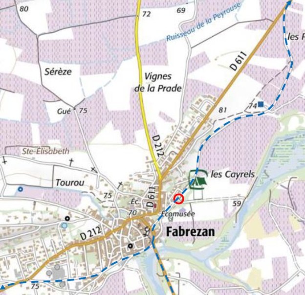
We return to Fabrezan in order to continue our journey on Les Tramways de l’Aude.  The tramway routes in the village of Fabrezan are shown as black lines on this map. The bridge over the River Orbieu is circled in red. The village station was on the northern edge of this map. [1]
 The two images above show the bridge at Fabrezan. The first, at the time the tramway was in use, the second, in the early 21st century. [1]
 This postcard shows a view of the village and bridge and is taken in the early 20th Century from the East. [2]
 This view is taken from the West. [3]
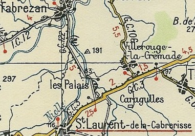
 After crossing L’Orbieu the tramway followed the GC112 (D611) as far as Les Palais. In the course of this short journey, it first followed the wetsern shoulder of the GC112 and then swung away from the old road to the West, to loop round to join the road crossing the River Nielle a tributary of L’Orbieu. It appears that the modern D611 now follows the tramway alignment. The tramway then swung southwards through the hamlet of Les Palais and then entering the village station.
Les Palais station is in the middle of a triangle of tracks which allows trains to be directed between Fabrezan, the terminus at Mouthoumet and Thezan, This is not in an urban area, it is isolated and only a short distance from Saint-Laurent-de-la Cabrerisse, hence the legend of the postcard below. The two-storey building is used as a residence by the station manager and his family, the ground floor is reserved for the administration. The stationmaster’s wife is also at her window, there is also a group of young girls among whom there are probably two twins, if we can trust their identical clothes. … Barrels lie on the ground, and we can decipher the names of their owners: A. Bouyssiere, Paris; Monsieure Fabre; Monsieur Monge; Monsieur Boussieux. Behind, the water pump seems to be in action feeding the locomotive, the water comes from the River Nielle. The goods train, of which we can see two wagons, comes from Mouthoumet and is bound for Thézan. The rails we can see in the foreground are the siding serving the loading platform. [4]
 The station building at Les Palais in the very early 21st Century!
 A schematic plan of the station. [13]
Continuing eastward towards Thezan and La Nouvelle, the train passes in front of the Pech Maurel farm, crosses the road to Coustouge, in the Aude, not to be confused with Coustouges in the Pyrenees Orientales, and approaches the Parazols stopover at KP 17,502, named after a stream. However, we will leave that arm of the tramway and focus on the westerly route to Mouthoumet.
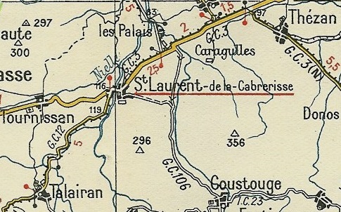
Heading West from Les Palais, the tramway first encounters Saint-Laurent-de-la-Cabrerisse.

 As the adjacent Michelin map from the 1930s shows the tramway followed the northern shoulder of the GC3 (D613) to Saint-Laurent-de-la-Cabrerisse and the station can be picked out on the North side of the road close to the village.
The tramway continued from there through Talarain, Villerouge Termenes, Felines Termaines, Laroque de fa and on to Mouthoumet.


 The images immediately above show the station at Saint-Laurent-de-la-Cabrerisse. The second image shows the GC3 road (on the right) with a train approaching from Les Palais. The first image shows an altogether much busier scene taken from the approximate location of the train in the second image. [5] The smaller adjacent image is taken at a similarly busy time to the first image above. [7]
 Saint-Laurent-de-la-Cabrerisse, Avenue de Narbonne. the location is probably a few hundred meters closer to the village centre than the station. [6]
 The picture above possibly sows the same location in 2017.
The adjacent image is taken in the opposite direction on the Avenue de Narbonne. Close to the centre of the village. [12]
 The tramway – looking back into the village of Saint-Laurant-de-la-Cabrerisse. [10]
 Looking back along the line of the tramway/road into the village of Saint-Laurent-de-la-Cabrerisse in the early 21st Century. The picture is taken from almost the same position as the monochrome image above. It is interesting to note that the church tower has been rebuilt but that the design is different!
 The bridge at Saint-Laurent-de-la-Cabrerisse at the time of the tramway. [8]
 The bridge was destroyed during WW2. This was the temporary structure built to replace it. [8]
 After Saint-Laurent-de-la-Cabrerisse, the tramway headed southwest, along the eastern shoulder of the GC12 (D613) towards Talairan. At first the road and tramway travelled across open vineyards but as Talairan came closer the tramway and road found themselves within the increasingly narrow valley of the Ruisseau de Remouly a tributary of the River Nielle. The tramway had to negotiate a more tortuous course alongside the river.


 The station at Talairan appears in the three postcard images immediately above. [9][10]
 A schematic plan of the station at Talairan which was alongside the road approaching the village of Talairan from Les Palais. [11]
 After passing through the centre of Talairan the tramway followed the southern shoulder of the GC12. [10]
 A similar view in 2017.
Then next village along the line was Villerouge-Termenes, an intersting historical village with a large castle. The tramway stayed above the village on what is now the D613.
 An excellent schematic plan of the village. [17]
 The Cathar Castle of Villerouge-Termenes. [14]
 The tramway route was about 100 metres behind the church in this image. [15]
I have been unable to identify the actual location of the station in the village – it seems as though the most likely location is an area of open ground to the south of the church and on the south side of the GC12 (D613) The area laaid out for parking at the bottom of the adjacent image. The church can be seen at the top of the picture and the village is just off the north edge of the photograph.
A short distance after Villerouge the tramway entered Felines-Termenes. On the way there it was necessary for the tramway route to separate from the road as the GC12 encountered a steep gradient. The two routes are highlighted on the satellite image below. The tramway came down the hill into Felines-Termenes following the Ruisseau du Gazel and after crossing the Ruisseau de Saint-Jean it crossed the River Libre. The station was 100 metres or so beyond the bridge over Le Libre. Its layout is shown immediately below. [16]


 The three images immediately above show the site of the station at Felines. I is impossible to finally confirm the exact location of the station but the barrage in the plan above appears to be visible in the river on Google satellite images of the village as shown below. [16]
 The red flag denotes the station location, the barrage referred to above is in the River to the Northeast of the station. Philip Morand says: the station was at 42.987159, 2.612986, where there’s another stone water tower and the remains of a building (south east of the co-ords I’ve given) which I think is the ‘mining silos of iron’ shown in the plan of the station” above. [24]
 The water tower mentioned by Philip Morand can be seen in this Google Streetview image.
Beyond Felines-Termenes the tramway and road meandered through the forested hills to Laroque de Fa. Once again the tramway and main road remained outside the village of Laroque and on this occasion, travelling round three sides of the village.
 The tram approaching Laroque on the GC12 (D613). The road can be seen to the right of the tram. It is difficult to locate the station in the village but the 1930s Michelin map shows the tramway on the left side of the road travelling round the village and then just to the North of the village on the GC12 switching to the other shoulder of the road to complete the journey to the terminus at Mouthoumet [18]
  Approximately the same location as the above monochrome photograph in the early 21st century.
Philip Morand who lives in Laroque de Fa says: “I think the station in Laroque de Fa was at 42.958147, 2.568130, where there’s also a short stone tower which I’m told was used for water for the steam locomotive. Nowadays the space is used as an unofficial aire for camper-vans and the Marché nocturne in the Summer.” The location, to the Northeast of the village, is shown on the map and in the photo below (September 2012). [24] 

 A crumbling bridge in Laroque! [23]
 Almost the same location in 2017.
 This image shows the tramway curving around the village and the picture below shows the same location in the early 21st century. [21]
 The remaining journey to Mouthoumet was completed on the South side of the GC12.
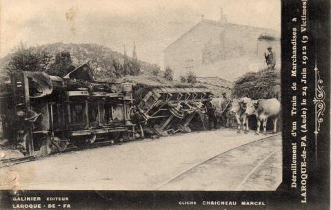
 Before leaving Laroque it is worth noting that there was a tramway accident in the village in 1912. [19]
The accident is noted on Les Forums de Passions Métrique et Etroite!! [19]
This note is provided on that forum in French. It has been translated using “Google translate”:
“This Monday, June 24, 1912, it is 1 pm, from Monthoumet, the machine No. 11 driven by the mechanic Mr. Olive, enters the village, pulling behind a wagon of forage which may have been badly loaded or the load may have shifted. The locomotive and wagon derailed and, in its fall, disemboweled the wall of Dr. Lautier’s shed. Jets of vapours escaped from the exploding boiler burning to the third degree. The unfortunate Mr. Olive, according to the witnesses of the scene, did not die quickly, but his sufferings were atrocious. He absorbs into his lungs the steam that escapes. Despite all the care that will be lavished on him, he will die the next day at Lézignan hospital. ”
The source of this short story is Mr. Fabre, quoted by Michel Vieux, Steam Tramway of the Aude, p. 102. [4]
Having noted this accident and particularly having commiserated with those affected by it, we move on towards the terminus of the line at Mouthoumet. The tramway followed the lefthand shoulder of the GC12. Gradients along this final length of this branch of the tramway were not steep and the final few kilometres of the tramway were straight as a die. The station was set to the north of the main road. North is at the bottom of the plan below.
 The road on the right of the photograph above is Rue de la Gare. The engine shed would have been at about the location of the young Cyprus Tree, perhaps just beyond it on the line of the side road. The main road turns away to the south in the image, just as it does on the sketch plan above.
 The tramway station was immediately in front of the Gendarmerie in Mouthoumet! [22]
 The station at Mouthoumet. [20]
Another journey is over. …. In the next post we will return to Les Palais and start to explore the remainder of the Tramways de i’Aude system.
References
- http://www.inventaires-ferroviaires.fr/hd11/11203.a.pdf, accessed on 15th October 2018.
- https://www.geneanet.org/cartes-postales/view/4728335#0, accessed on 18th October 2018.
- https://www.geneanet.org/cartes-postales/view/4728343#0, accessed on 18th October 2018.
- Michel Vieux; Tramways a Vapeur de l’Aude; R. Latour Editions 14 rue Sébile 09300 Lavelanet, 2011.
- https://www.cparama.com/forum/saint-laurent-de-la-cabrerisse-t29081.html, accessed on 18th October 2018.
- http://www.thezandescorbieres.com/train.htm, accessed on 18th October 2018.
- https://www.communes.com/cartes-postales-anciennes-saint-laurent-de-la-cabrerisse, accessed on 18th October 2018.
- https://www.geneanet.org/cartes-postales/search/?country=FRA&go=1&place=saint-laurent-de-la-cabrerisse&sort=date_depot, accessed on 18th October 2018.
- https://www.geneanet.org/cartes-postales/view/5928362#0, accessed on 18th October 2018.
- https://www.delcampe.net/fr/cartes-postales/europe/france/11-aude/autres-communes?f=keyword:talairan, accessed on 18th October 2018.
- http://www.cpaaude.fr/THEMES/TRAMWAYS/index_fichiers/Page3929.htm, accessed on 18th October 2018.
- http://www.cpaaude.fr/THEMES/TRAMWAYS/index_fichiers/Page3875.htm, accessed on 18th October 2018.
- http://www.cpaaude.fr/THEMES/TRAMWAYS/index_fichiers/Page3648.htm, accessed on 18th October 2018.
- http://www.beyond.fr/villages/villerouge-termenes.html, ,accessed on 19th October 2018.
- http://chateauvillerouge.wix.com/termenes#!, accessed on 19th October 2018.
- http://www.cpaaude.fr/THEMES/TRAMWAYS/index_fichiers/Page4163.htm, accessed on 19th October 2018.
- http://www.belcaire-pyrenees.com/article-le-chateau-de-villerouge-termenes-2eme-partie-50304313.html, accessed on 19th October 2018.
- http://www.cpaaude.fr/THEMES/TRAMWAYS/index_fichiers/Page4005.htm, accessed on 19th October 2018.
- http://www.passion-metrique.net/forums/viewtopic.php?f=2&t=9326&start=90, accessed on 19th October 2018.
- http://www.cpaaude.fr/THEMES/TRAMWAYS/index_fichiers/Page4066.htm, accessed on 19th October 2018.
- http://www.laroquedefa.fr/village/photos1900.htm, accessed on 19th October 2018.
- http://www.audecathare.fr/villages/mouthoumet.htm, accessed on 19th October 2018.
- https://www.cparama.com/forum/laroque-de-fa-t249.html, accessed on 19th October 2018.
- Email from Philip Morand on 14th July 2019.


Very interesting. I’ve often wondered about the route in view of the many gradients.