

The featured image above shows one of the construction trains used for the extension from Gulu to Pakwach,© M. Hardy-Randall. [8]
Our journey in this post begins at Gulu and when we leave the town we head west towards Pakwach. We start this post with a couple of photographs taken in Gulu.

111510: Gulu, Uganda. An Officers Inspection Car No 116, taken in August 1971, (c) Weston Langford. [1]

Level Crossing tarmacked over at Gulu, taken around 2010. [2]
Leaving Gulu Station we head for Pakwach. Thanks to Thomas Kautzor, I now know that the stations between Gulu and Pakwach were: Paliri, Bwobo, Aparanga, Pai Halt, Lolim and Pakwach East. Finding evidence of these stations has been difficult. Part of the problem with identifying locations is that the station names seem not to relate easily to the named locations on maps.
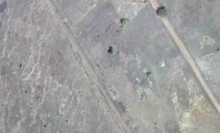
Out of Gulu, the line heads initially in a generally westerly direction and the image below is typical of the countryside through which the line travels.

The trajectory of the line changes when it reaches Alelele. It heads in a south-westerly direction towards Alero.

After Alero, the line travels in a south-southwesterly direction through Nwoya and on through Patit and Patera to Aparanga where reports indicate that there is a railway station of sorts. [3] It can be just picked out centre-left on the satellite image below. I have found no photographs of the station/halt.
The next station I can find any possible location for along the line was some distance further to the West at Lolim. On the way to Lolim, the railway and the Gulu-Arua Road followed almost the same course through, or close to, Lalem, Purongo, Wianomo and Wianaka.
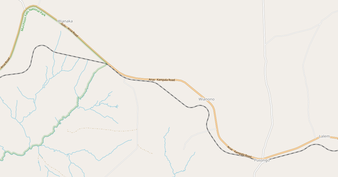
Near Wianaka, the road skirts the northern edge of the Murchison Falls National Park. The railway predates the formation of the National Park and so transgresses its boundaries, (see the left hand side of the map above).

Going on to Lolim, while the railway snakes around, the road from Wianaka follows the Park boundary, (as above). The most likely location of the Railway Station at Lolim is shown in the satellite image below, which is just off the left of the map above. Again, there are no photos of the station and there is little evidence on the satellite image to confirm its location.

From Lolim, the railway and road continued on a relatively similar alignment. The railway follows the contours to minimise gradients, the road takes a more direct route. Both meet short of the bridge over the Albert Nile near Pakwach.

By the time the bridge is reached the railway and the road are on exactly the same alignment with the rails let into the surface of the road. In the first set of images below, the rails are clearly visible in the tarmac surface of the road over the bridge. [4][5][6]
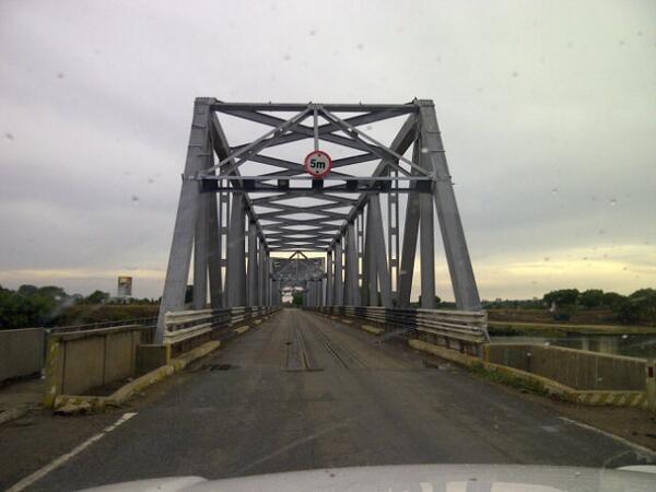


The second couple of photographs show the bridge from along the banks of the Albert Nile. [7][2]


Arriving at Pakwach the railway turned to the West off the bridge. At present, the line stops at the end of the road/rail bridge. The line passed through the centre of Pakwach and was extended, in 1969, to Arua.
All evidence of that extension has possibly disappeared under the formation of the Pakwach-Arua Road. There are short sections where the road alignment does not seem to have covered the old railway formation. One example is shown in the adjacent satellite image. In the Mbaro area, where, over a short length, the road travels north-south before reaching Oryang, the railway alignment can just be picked out to the east-side of the road.
However, this route has some questions attached to it. … When the Pakwach-Arua Road reaches Nebbi it turns through an sharp, acute angle at a roundabout. The alignment of the road in Nebbi is vary unlikely to be the alignment of the original metre-gauge line. There is a possible cut-off route for the line which avoids Nebbi. Its alignment can be picked out on the satellite image below. It starts on the eastern edge of the image close to the village of Namrwodo and runs just north of west across the image before turning north-west and then meeting the Gulu-Arua Road once again.
We know that the railway reached Arua in 1969. It may have taken this route or another route and I cannot find enough evidence to establish the actual route at present Nor can I identify the site of the Station in Arua. This is an unsatisfactory end to the story of this line. Perhaps in due course I will find more information, or possibly someone who has more information will come forward.

In the next Uganda Railways post we return to Tororo, and begin to focus once again on the mainline to Kampala.
References
- http://www.westonlangford.com/images/gallery/four-days-in-uganda, accessed on 29th May 2018.
- http://www.works.go.ug/wp-content/uploads/2017/02/1604-Tororo-Pakwach_Consultancy_of_feasibility_Final%20Report_2016-10-18.pdf, accessed on 1st June 2018.
- http://ug.geoview.info/aparanga_station,8200502, accessed 3rd June 2018.
- http://www.celebritypix.us/celebrities/pakwach-bridge-celebrities-88877.html, accessed on 3rd June 2018.
- http://trip-suggest.com/uganda/northern-region/pakwach, accessed on 3rd June 2018.
- http://justasurferdude.blogspot.com/2012/05/we-all-are-one.html, accessed on 3rd June 2018.
- https://www.westnileweb.com/special-features/features/our-regions-have-too-much-potential-how-are-you-developing-them, accessed on 3rd June 2018.
- https://friendsoftherail.com/forum/download/file.php?id=4524&mode=view, accessed on 22nd July 2022.

Between Gulu (km 375.4) and Pakwach the stations were:
395.0 Paliri
414.9 Bwobo
440.3 Aparanga
456.0 Pai Halt
469.2 Lolim
502.9 Pakwach East
At Arua, the line is said to have ended at a mine.
Thank you Thomas. I have adjusted the test of the blog to accommodate your comments. I appreciate them.
Best wishes
Roger
Re Pakwach to Arua railway line. I do not think this line was actually constructed. I understand your point about the aerial images and possible former alignments along the Arua to Packwach Road but feel these are likely to be re-alignments of the road.
The line to Pakwach East was completed in 1964. The station site is faintly visible on Apple, Bing or Google Aerial. The line ran slightly south of the current line, NE of the present ‘oil exploration site’. The turning triangle, very faintly visible on Apple, was under the oil site. The Nile Bridge was completed in 1969 and the revised rail line ran across the bridge and straight ahead (not curving into town as per OpenRailwayMap) to the warehouse visible on all three aerial.
Spear (EARHC magazine) volume 6-7 (Feb 1964)
the route … was largely determined by the site of the possible future crossing of the Nile and the further extension to Okollo and Arua
Spear (EARHC magazine) volume 7-1 (Feb 1965)
At Pakwach East there is a combined station office and parcel store, goods shed (3,000sq ft), a loading platform, an end-loading ramp, an oil fuel installation and a turning triangle.
Spear (EARHC magazine) volume 8-9 (1969)
The last span was floated into position on 17 April 1969.
2016 feasibility report on Tororo – Pakwach line
The railway line was due to continue to Arua, which is about 112 km northwest of Pakwach, but the works stopped.
Hi Adrian
Thank you. You may well be right, but there are other sources which have the line running through to Arua – either in 1964 or 1969. For example:
Nairobi Railway Museum:
https://web.archive.org/web/20100126134859/http://www.greywall.demon.co.uk/rail/Kenya/nrm.html
and Ove Arup in a report on emerging cities:
https://www.arup.com/-/media/arup/files/publications/f/future-cities-africa–uganda.pdf (page 17).
I guess from the sources you quote that the balance is possibly in favour of the line not having been built. However Arup should be a reputable source.
Very best wishes
Roger
Thankyou for this wonderful post
I wish to correct you that the Rail way line run a Tourist line along the Nile on the Westbank in the very direction it jugs out of the Tailway bridge running parallel with the mighty River Nile that swell in this section of the Albert Nile to two miles in some places looking like a sausage tree fruit and only stopped at the Iconic Ajai Game Reserve in Madi Okollo made famous for the site of MGM very first talking Movie Trader Horn 1929 and released in 1931 in cinemas
McCrow takes time to explain the above in a better article.
It was the sight of big game Hunt for White Rhinos by former Head of State H.E. Teddy Roosevelt in 1909-1910
Hi, thank you for the comment, please could you let me have the details of the McCrow website to which you refer. Kindest regards. Roger Farnworth.