Around 100 yards from our home in Telford there was once, many years ago, a colliery that was served by a tramway/waggonway.
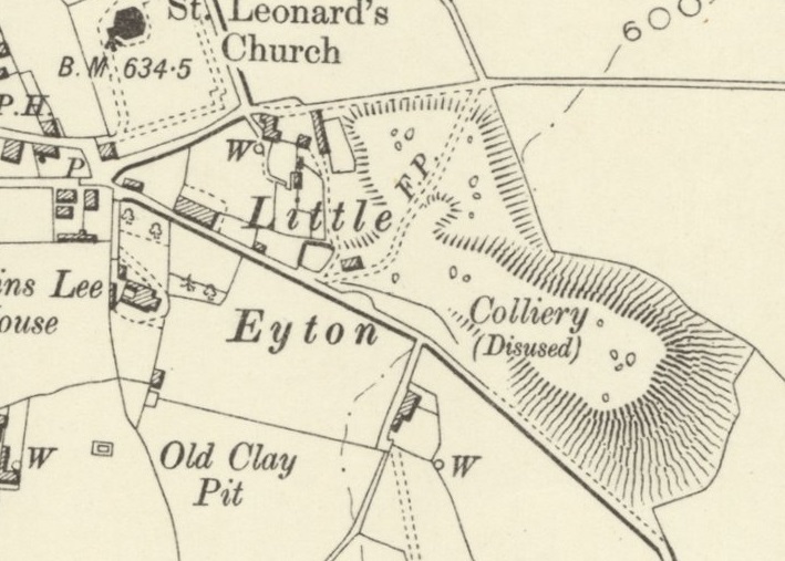
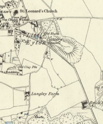
Little Eyton Colliery was already disused by the time the survey was undertaken in 1881/1882 for the 6″ OS Maps published in 1888. The tramway had not yet been lifted, so it appears on the map extract below.
The Mindat.org website tells us that the colliery was owned in 1890 by the Haybridge Iron Co. It was in the ownership of the Stirchley Coal & Iron Co. from 1895 to 1896 and was back in the hands of the Haybridge Iron Co. by 1900. [3]
The Dawley History Website tells us that the Chartermaster in 1869 was Edward Bailey. [4]
There was a mining accident in 1869 at the Little Eyton Pit. … The Wellington Journal on Saturday 17th April 1869 carried this report:
The Late Fatal Accident. – On Saturday last an inquest was held at the Bull’s Head Inn, Lawley-bank, before J. Bidlake, Esq., on the body of Joseph Oliver, aged 37 years, whose death we recorded in last week’s Journal, when the following evidence was adduced:– John Oliver, son of deceased, deposed : My father worked at the Little Eyton Pit. Edward Bailey is chartermaster. It was a coal pit. I have worked at the pit a month. I have been driving. On Thursday morning, about nine o’clock, I was taking a draught of coal to the bottom of the shaft. I saw my father lying at the bottom with the basket on him. There was a lid on the basket, and another lid lying by the side of him. I ran off and told James Poole. I had seen my father about ten minutes before at the bottom. There was no one with him. He did not speak to me when I found him under the basket. I saw that his head was cut on the top, and also behind. He was lying on his back. One end of the basket was sticking up against the shaft, the other end on his stomach. The lids are about 2 ft. long. The lids on being sent down are tied under the tackler. – James Poole said : I work at the Little Eyton Pit. The last witness came and told me that his father was under the basket at the bottom of the shaft. I went there and found him. The deceased was lying at the bottom, with his head in the shaft, and not in the road. There was one lid in the basket not fastened, and one by him. He was about a yard from the side of the shaft. Three or four lids are generally sent down at a time. They are not usually lashed. There was no lasher round the basket when I saw the deceased. The lids are about three quarters of a yard. The pit is 200 yards. The hooker-on generally calls for lids. He had called for some that morning. I told him to do so, and he told me that he had done so. This was about half an hour before I found him. – John Perks said : I am banksman at the Little Eyton Pit. On Thursday morning deceased shouted for some trees and lids. I sent some down. I remember sending the last two lids down. It would be about half-past eight. I shouted “Joe” when I sent them down, but I got no answer. They were put under the tackler between the squares. We lash the trees. I have known of lids falling out before. I did not hear this drop or the skip catch. The Jury returned a verdict of “Accidentally killed.” [4]
Little Eyton Colliery as surveyed in 1881/82 for the 6″ OS Maps of 1888. The tramway leaving the map extract at the bottom right runs from the colliery towards the Wellington to Coalport Branch of the LNWR (later LMS). Before the coming of the railway, the tramway will have had wharves on the Coalport Branch of the Shropshire Canal. The railway company made use of the route of the Canal but as we will see, the horizontal.alignment of the canal was not always suitable for the railway. There is also a length of tramway running from the pit head out onto the slag heap. It leaves the map extract to the North of the other line. [1]
By the time of the next OS survey of Malinslee, just after the turn of the 20th century, all traces of the tramways at the colliery site have disappeared.
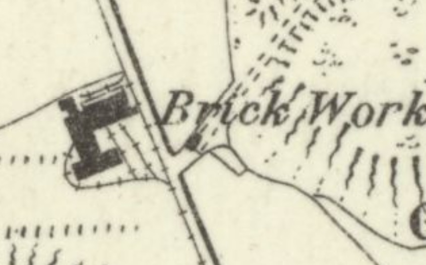
Little Eyton Colliery site at the turn of the 20th century. No tramway infrastructure remains at the site. The colliery slag heap remains and will continue to be a feature of the local landscape into the 21st century. [2]The same area in the 21st century as it appears on the ESRI World Image, Background map as provided by the National Library of Scotland. The large green sward of land surrounded by mature trees is the old colliery site and slag heap. The land remains significantly higher than the immediate locality and has been ‘rewilded’ to provide s pleasant meadowland and wooded area. [2]
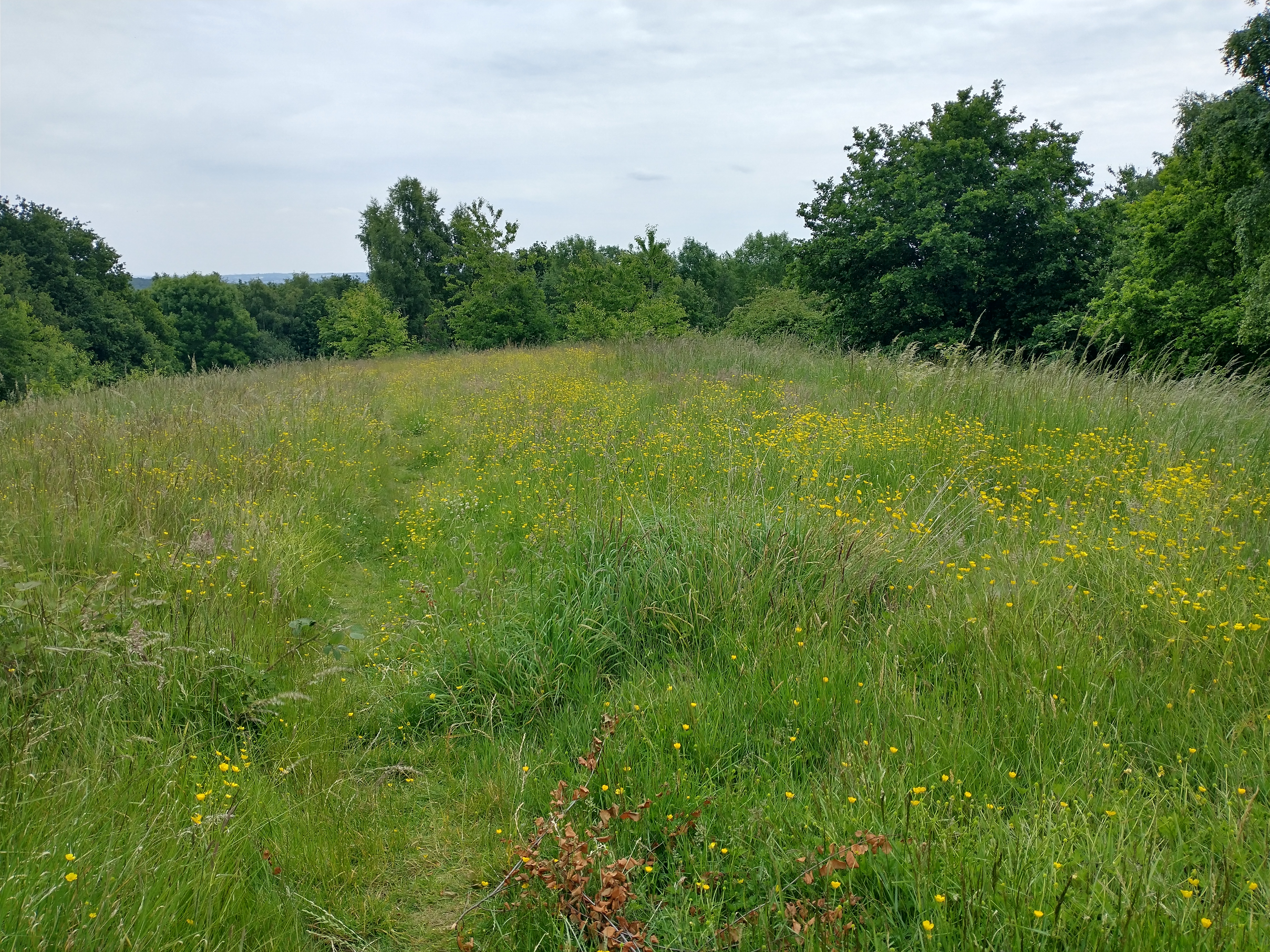
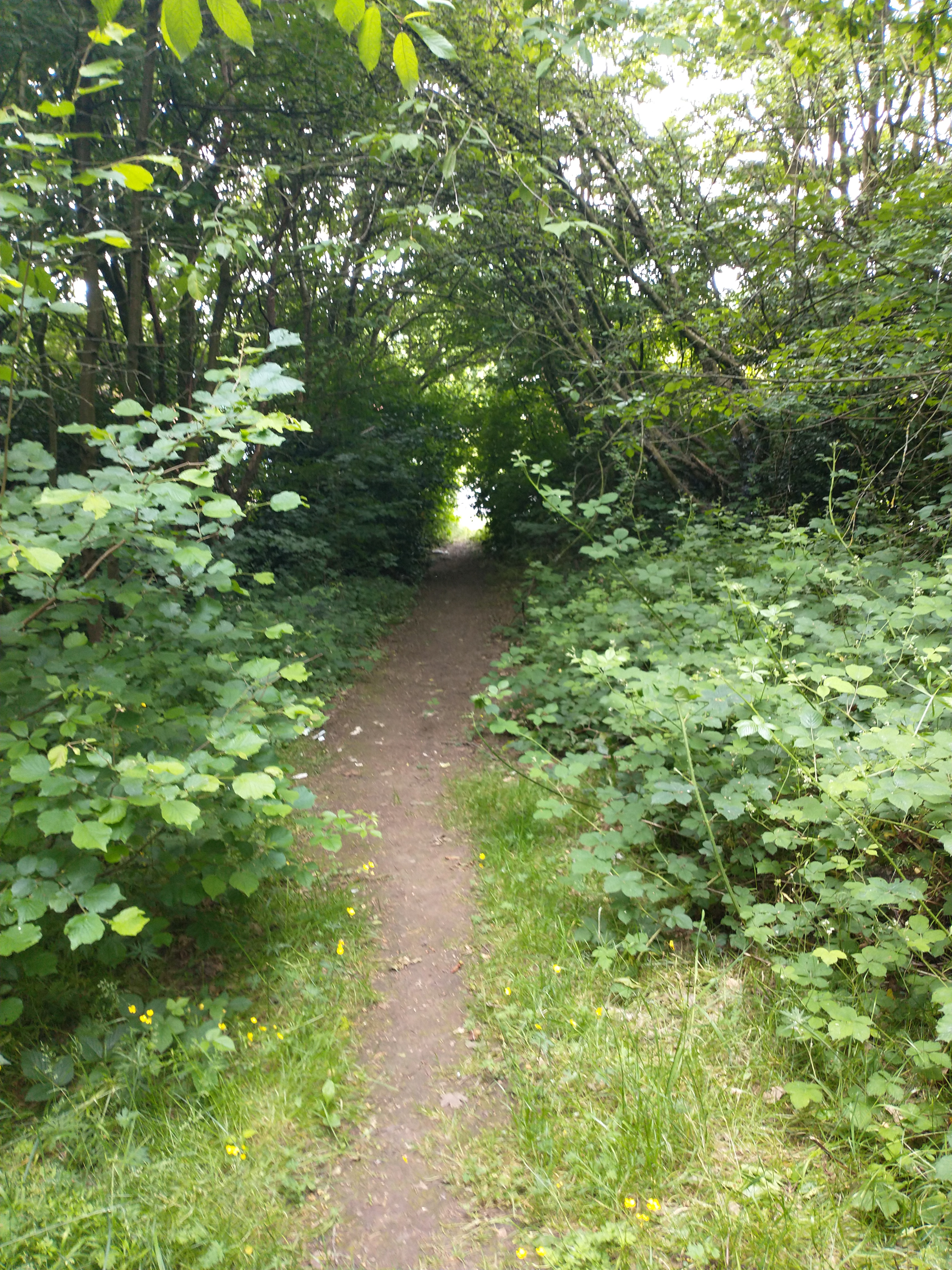
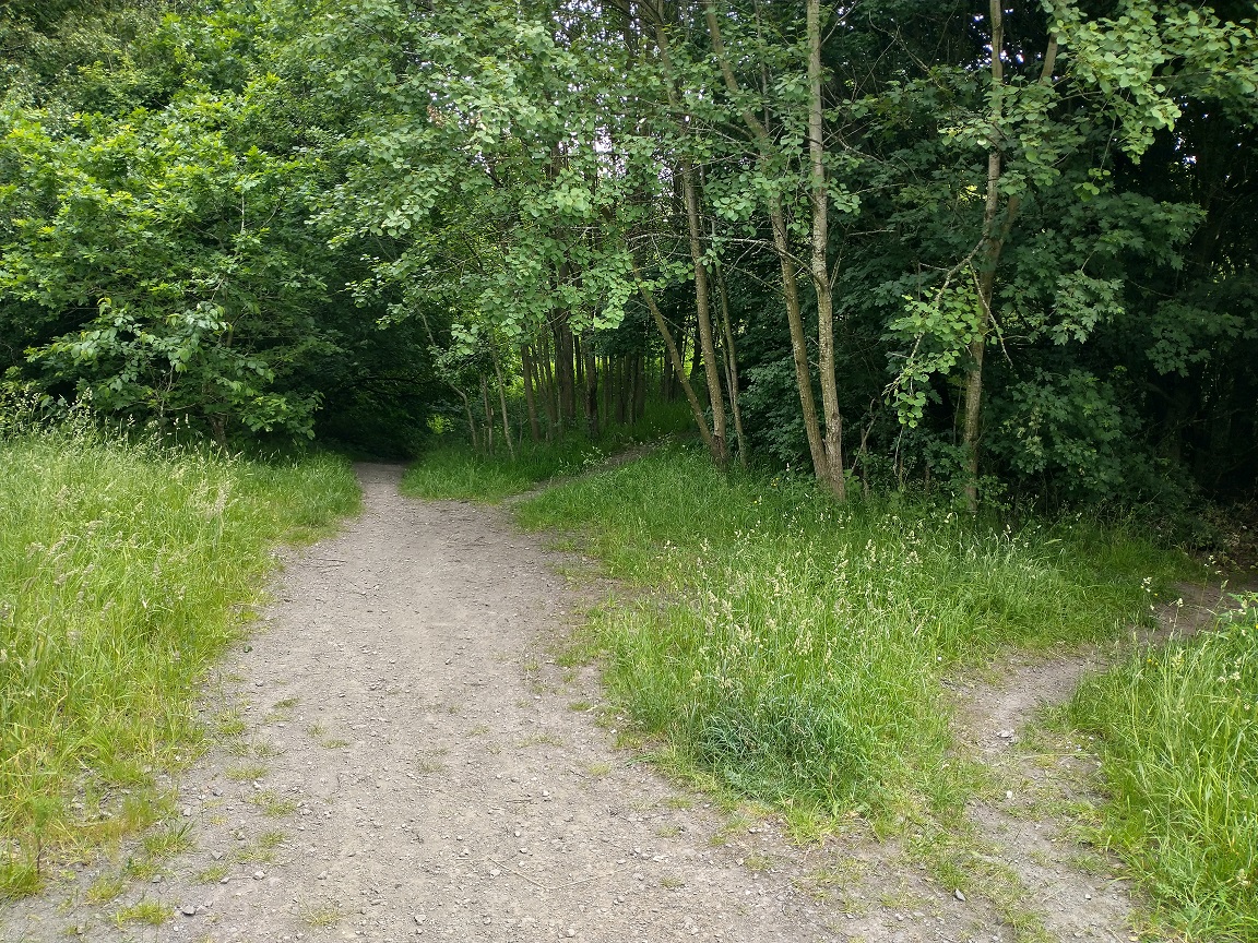
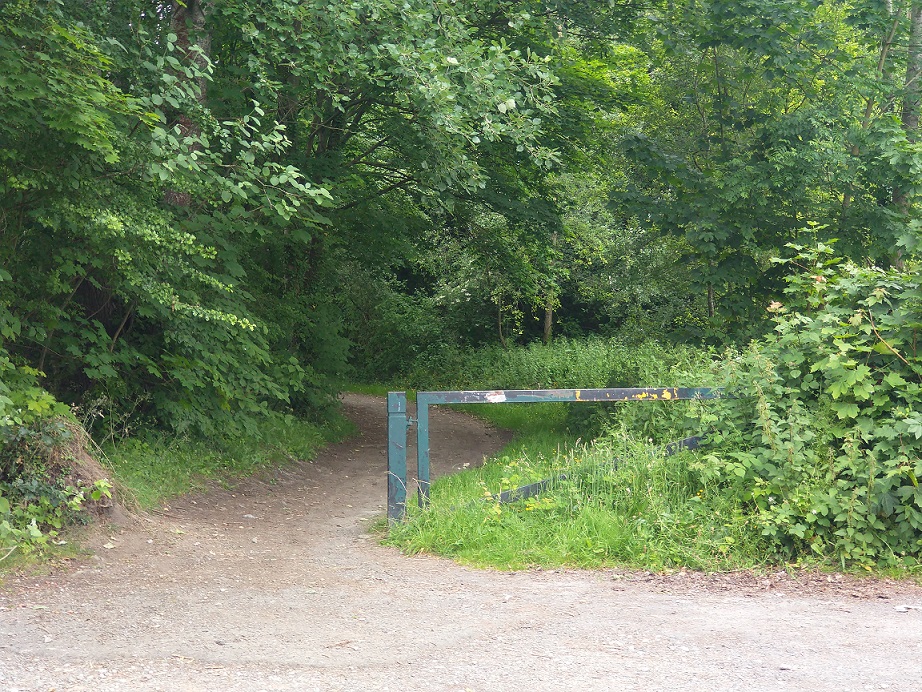
The next few photographs show the Little Eyton Colliery site in the 21st century.
Three photographs of the Little Eyton Colliery and Slag Heap site in the 21st century. [My photographs, 15th June 2022]
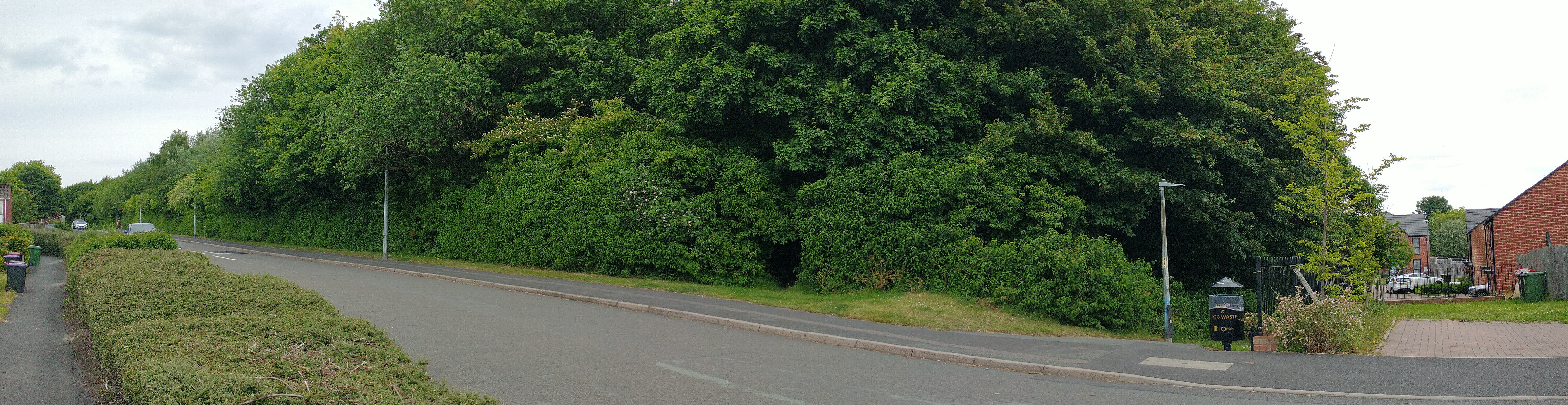
Leaving the colliery, the tramway followed the route of what is now Matlock Avenue.
Matlock Avenue alongside the old Little Eyton Colliery. The old tramroad followed the line of the road. [My photograph, 15th June 2022]The 6″ OS Map shows the area before anyone conceived of the housing developments of the mid-to-late 20th century which swallowed up Langley Farm. [6]As the tramway ran Southeast it served Langley Brickworks and Langleyfield Colliery. Both sites had private sidings, those for the Pit were more extensive than those at the brickworks. It was followed, on the journey, by the road linking Little Eyton with the White Hart Inn which was known locally as the ‘Jerry Inn’. [6]Looking Southeast along Matlock Avenue. The route of the old tramway ran approximately under the car in the foreground before passing to the left of the lamppost and litter bin Under the tree in the centre-top of the image and heading down a ginnel between two different housing developments ahead. [My photograph, 15th June 2022]Looking South east along the line of the old tramway. The footpath runs between two housing estates and provides access to Telford Town Park. [My photograph, 15th June 2022]The area around Matlock Avenue and the route of the old tramway as it appears on Satellite images from April 2021. [Google Earth]Looking Southwest at the corner of the Brickworks site. [My photograph, 15th June 2022]The Brickworks Site looking Southwest onto the site from the line of the old tramway. The trees ahead have been allowed to grow across the site of Lawley field Colliery and its Slag Heap. The old tramway ran down the line of a modern footpath off to the left of this image. [My photograph, 15th June 2022]Details of the surveyed tram tracks at the Brickworks. The extract comes from the 6″ OS Map above. [6]Two images from the site of Langleyfield Colliery which has been allowed to revert to nature. [My photographs, 15th June 2022]The tramways serving the Langleyfield Colliery site. The extract comes from the 6″ OS Map above. [6]Looking Northwest along the line of the old tramway towards Matlock Avenue. The route continues to be a surfaced footpath running along the western edge of Telford Town Park. [My photograph, 15th June 2022]The same footpath, this time looking to the Southeast. The railings ahead are at Hinkshay Road. [My photograph, 15th June 2022]
The Dawley History website provides the following information about the Langleyfield site:
Langleyfield Collieries Ownership:
Coalbrookdale Company 1803 – 1826 Langley Field Company 1826 – 1856 Beriah Botfield 1856 – 1872 Haybridge Company 1872 – 1885 The site records the pit(s) having been sunk in ca. 1803 and closed ca. 1885. [7]
The website quotes Malcolm Peel, in his book, ‘The Pit Mounds of Dawley’ says that at Langleyfield: “There were at least ten shafts working at various times between 1803 and 1885, and they produced coal and ironstone. This large colliery was originally owned by the Coalbrookdale Company and in 1826 was sold to the Langley Field Company in which George Bishton and Adam Wright were partners. The colliery, ironworks and brick yard established here by Bishton and Wright were bought by Beriah Botfield in 1856, and after the breakup of the Botfield Empire the colliery was owned by the Haybridge Company.[7][8]
In addition the Dawley History site highlights a short article in the Shrewsbury Chronicle on Friday 25th March 1836 advertising an auction of property at the Jerningham Arms Inn, Shiffnal, on Tuesday, 12th April, 1836, “at four o’clock in the afternoon, in one or more lots, or shares, and subject to such conditions as shall be determined on at the time of sale.” [7]
The sale included, freehold, around 30 acres of land and “two dwelling houses, with nine Cottages for workmen, Warehouses, Shops, Stables, Outbuildings, Yards, and Gardens, and several pieces or parcels of Land thereto belonging, situate at Langley Field, in the parish of Dawley Magna, in the county of Salop, … with the Mining works thereon erected, and the valuable Mines of coal, and iron-stone, clay, and other minerals under the same.” [7]
Also for sale were “two blast furnaces, one bridge house, two casting houses, one blast engine sixty horse power with four boilers complete, three cupolas (one at work as a foundry, and has a good casting house and stove, and the fires are blown from the blast engine), one steam engine to wind materials to the top of the furnaces, a blacksmith’s shop, an air furnace for heating boiler plates, and a punching engine, three machines for weighing coals and stone, three field winding engines, several shafts down to the mine, two stoves, one oven, one kiln for making bricks, and a mill for grinding fire clay, and every other possible convenience for carrying on the mines and works in full vigour.” [7]
According to Eddowes’s Journal, and General Advertiser for Shropshire, and the Principality of Wales – Wednesday 21st August 1844, the site was up for sale once again.
Of interest to us, in addition to a glowing and detailed description of the site and items for sale, is the following paragraph:
“The property is intersected with tram roads in every requisite direction, and is admirably arranged for carrying on the works at as little expense as possible, and contains within itself every convenience required for making superior iron, and the whole of the works may be put into full operation in a very short space of time, at a comparatively trifling outlay.” [7]
Elsewhere, the Dawley History site notes that the tramway was in use in the early 19th century. It was “known locally as the Jerry Rails. The now demolished nearby public house, The White Hart, was referred to in the 1861 census as the ‘Tom & Jerry’, called locally the ‘Jerry’. The name was obviously associated with the tramway and other features in the area.” [5]
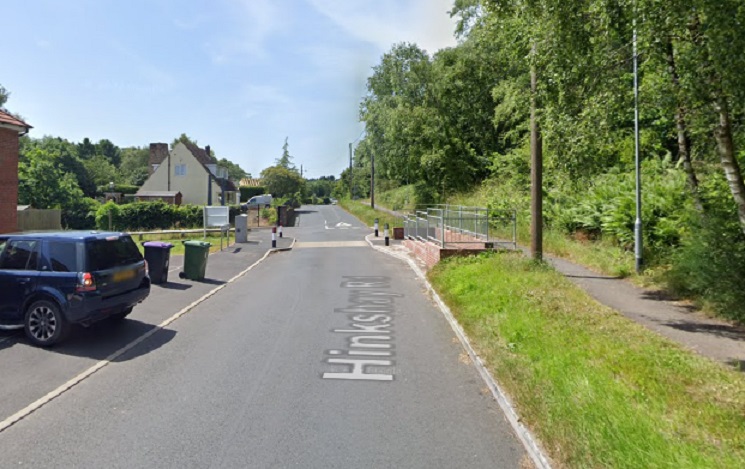
The junction of Hinkshay Road and the public road from Little Eyton. The now demolished White Hart In dominates the junction which was also a significant tramway junction. The line we have been following enters the extract from the top left and encounters a trailing connection with the lines serving Langleyfield Colliery. Two lines leave our tramway route at the road junction. One of these, runs Northeast towards what is now Telford Town Park. Another runs Southwest for a short distance. A passing loop can be seen on this line just before it exits the map extract. Our line continues in a Southeast direction. [6]Approximately the same area as in the map extract above but this time from April 2021 rather than the 19th centuryThe view across Hinkshay Road from the North. The ginnel ahead is the route of the tramway that we are following. Tramways branched right and left from this location along Hinkshay Road. [My photograph, 15th June 2022]Looking back across Hinkshay Road from the South. The footpath following the line of the old tramway is protected by metal gates. [My photograph, 15th June 2022]Looking along Hinkshay Road from the West across the location of the tramway junction. [My photograph, 15th June 2022]Looking West along Hinkshay Road. One of the tramway branches ran on the North (left) side of the road for a short distance. [My photograph, 15th June 2022]Looking West a little further along Hinkshay Road. The tramway once ran directly in front of these cottages before running off to the left. [My photograph, 15th June 2022]On the 6″ OS Maps the tramway can be seen curving away to the North of Hinkshay Road at this point. It seems to terminate in the vicinity of a church but probably served the collieries which stood on the North side of Hinkshay Road at this point. [My photograph, 15th June 2022]
We have explored the branch tramway which ran to the East on Hinkshay Road, we return no to look at the branch which runs to the West.
Looking to the West, towards Dawley on Hinkshay Road. The branch tramway ran, as far as I can ascertain, on the North (right) side of the road as far as the most distant houses that can be seen in this picture. [Google Streetview, May 2019]The tramway remained on the North side of Hinkshay road until taking a sharp left to run South towards an Ironworks. The route South is just beyond the low wooden rails on the grass area to the left of the road in this view. [Google Streetview, May 2019]Looking back North across Hinkshay Road from the route of the old tramway. [My photograph, 15th June 2022]Another extract from the 6″ OS Map. Hinkshay Road runs across the top left corner of the extract. The old tramway branch terminated at what was, in the 1880s, a disused Ironworks (Jerry Furnaces). It appears that the works were served, probably at two different levels from the North and the East. We will look at the tramway from the East a little later in this article. [6]
Returning to the junction on Hinkshay Road we continue our journey along the route of the tramway from Little Eyton Colliery.
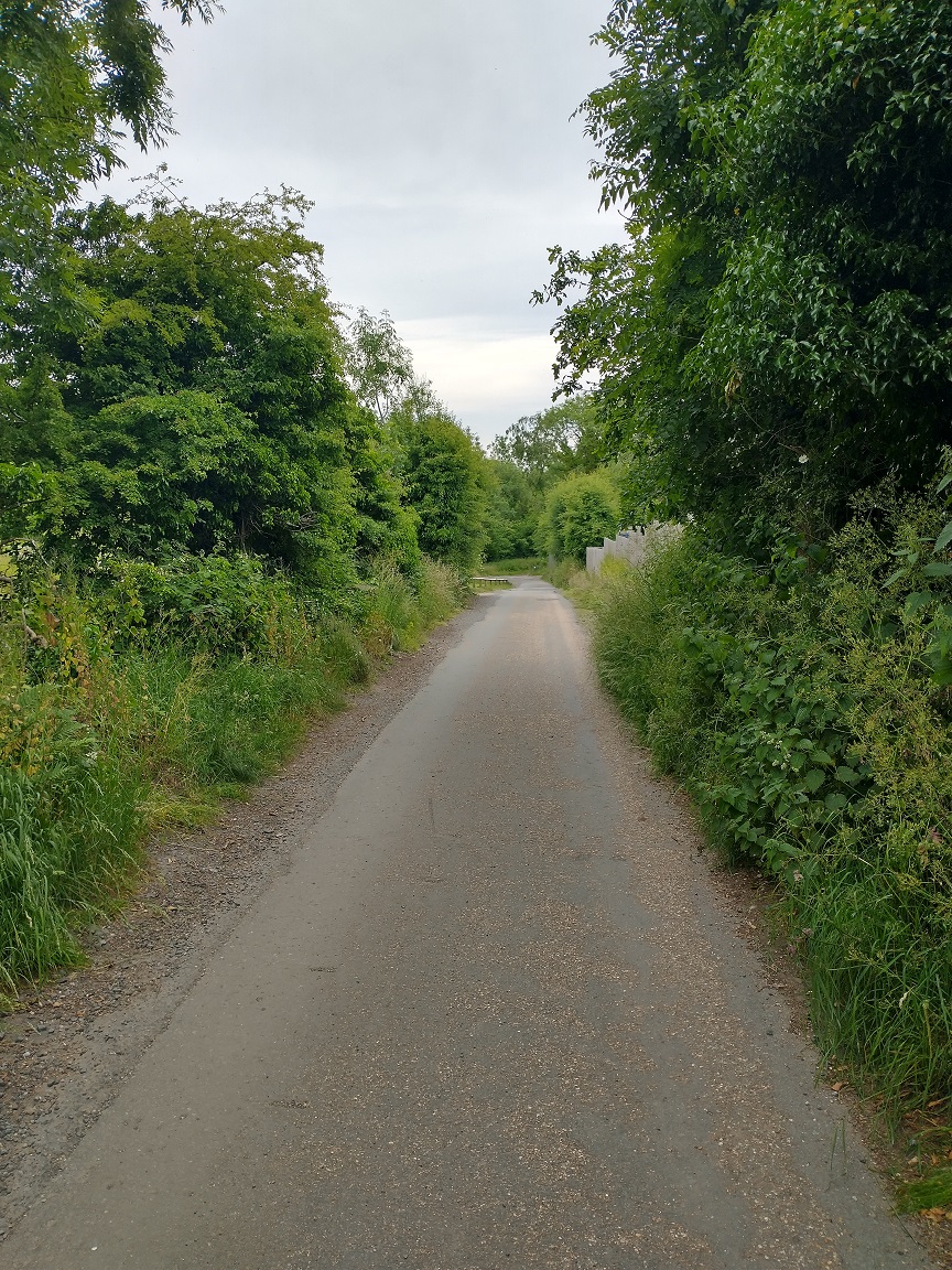
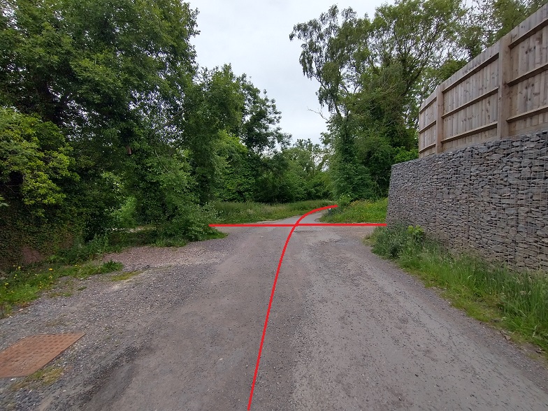
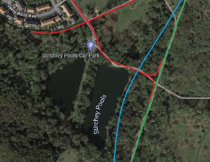
The old tramway route from Hinkshay Road runs along the metalled access to the modern car park at Hinkshay Pools. This view looks along the route from a point just South of Hinkshay Road. [My photograph, 15th June 2022]Close to the modern carpark we reach the point of another tramway junction. [My photograph, 15th June 2022]This extract from the 6″ OS Map surveyed in the early 1880s Shows the tramway crossing. The Ironworks that we have just encountered above (Jerry Furnaces) appear on the left of this image. South of those Works a tramroad runs Southeast past Hinkshay Pools which are given a blue wash on the map. In the bottom right of the extract, the line of the Coalport Branch of the Shropshire Canal is just visible. Our tramway route crossed the Canal on a bridge. The tramway running from the Ironworks on the left of the extract and crossing our route is a tramway which served Stirchley Ironworks. We will come back to this tramway in another article. [6]Looking West towards the location of the Ironworks. [My photograph, 15th June 2022]Looking East along the line of the tramway towards Stirchley Ironworks. [My photograph, 15th June 2022]This satellite image from early 2022 shows the approximate alignment of tramways in the vicinity of Hinkshay Pools as they are known locally (despite Google Maps calling them Stirchley Pools). Worthy of note is the green line which represents the standard-gauge Coalport Branch of what was the LNWR. The wharves alongside that railway were the terminus of the tramway that we have been following. Wharves were provided at a level above the Coalport Branch to allow easy loading of materials. The blue line shows the alignment of the Coalport Branch of the Shropshire Canal. The canal, at this location, can still be picked out as an elongated pool running close to the Hinkshay Pools. Also of interest is the name given to the estate road in the top left of this image. As we have already noted, the tramways in this vicinity were know as ‘Jerry rails’. [Google Maps]
We continue heading Southeast from the tramway ‘crossroad’ in the 6″ extract following the line between the Hinkshay Pools.
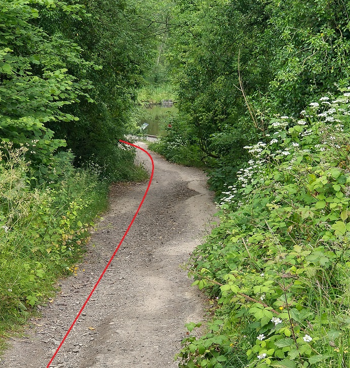
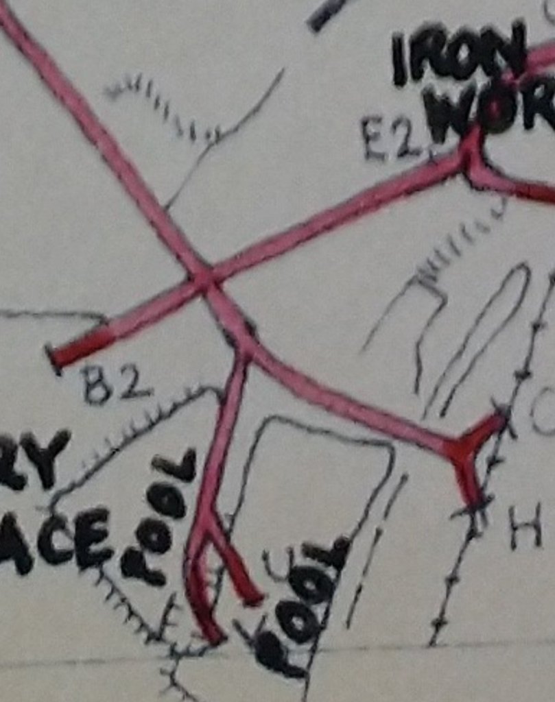
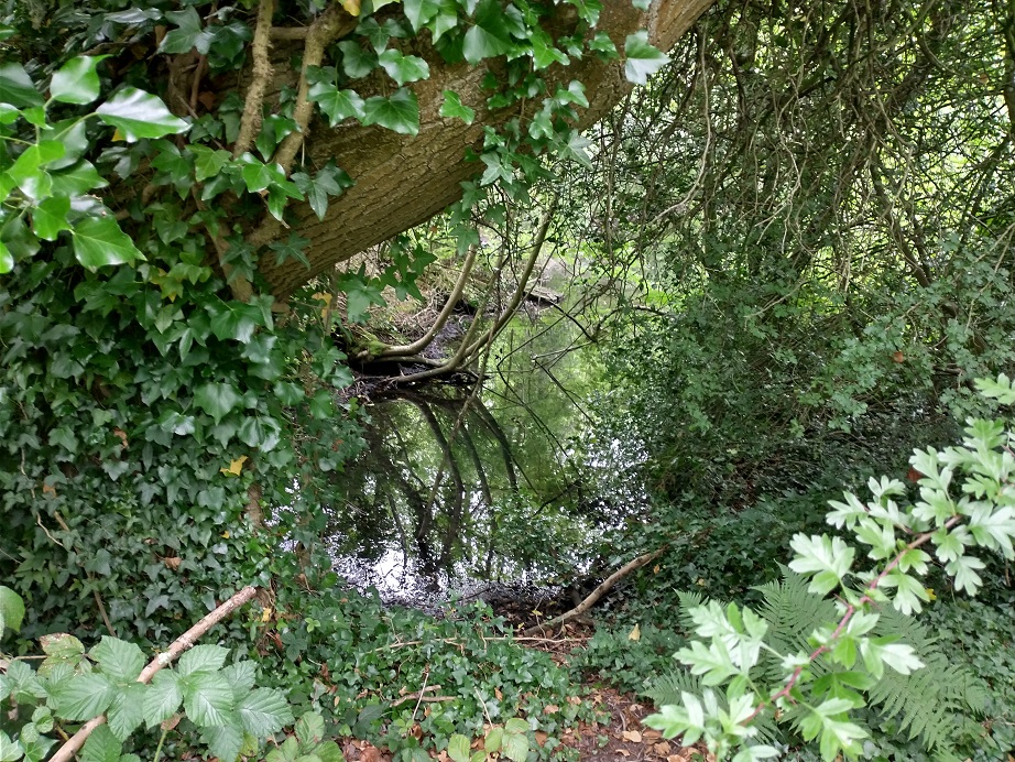
The access road swings to the right to enter the car park. The tramway ran ahead probably just to the left of the road as it disappears around the vegetation. [My photograph, 15th June 2022]Looking North from the Southern edge of the car park at Hinkshay Pools. The approximate line of the tramway is marked by the red line on the right side of the image. [My photograph, 15th June 2022]In this image we are facing Southeast at the same location as the image immediately above. The tramway followed the unsurfaced path round to the left. One of the Hinkshay pools is visible on the right of the image. [My photograph, 15th June 2022]The display board at Hinkshay Pools. [My photograph, 15th June 2022]The reference on the top right of the display board to the Coalport Branch of the Shropshire Canal is important as the canal ran along the East side of the Pools. [My photograph, 15th June 2022]One of the Hinkshay Pools. [My photograph, 15th June 2022]A remnant of the Coalport Branch of the Shropshire Canal. [My photograph, 15th June 2022]The tramway was carried over the line of the canal on an arched culvert which at least permitted ongoing drainage. Originally wharves would have existed along the side of the canal but once the railway was built the canal and its wharves would no longer have been required. [My photograph, 15th June 2022]This is the location of the Hinkshay Pools as drawn on a map of tramways taken from research undertaken by R.F. Savage & L.D.W. Smith and kindly made available by the Ironbridge Gorge Museum Trust Archive Office. It suggests that there was an additional tramway branch which ran out between two of the Pools. [9: p164] Savage and Smith say that the Lawleyfield Colliery had a wharf at this location in the early 1800s and that the lower pool was originally a canal wharf. [9: p166]Looking South-southwest along the line of the Canal. [My photograph, 15th June 2022]The remnant of the Canal on the North-northeast side of the tramway/footpath. [My photograph, 15th June 2022]
Immediately to the West of the Canal the tramway we have been following divided in two to access a wharf/wharves alongside the Coalport Branch of the LNWR.
A siding, accessible from both ends, was provided along side the Coalport Branch as can be seen in this extract from the 6″ OS Maps of 18888 (surveyed in 1881/82). The rail-side tramway track would have been at a height above the railway siding which allowed easy offloading of the waggons, probably by hand. [6]Looking back to the West from the line of the Coalport branch along the tramway alignment. [My photograph, 15th June 2022]
In Part 2 of this review of tramways in the Malinslee area, after wandering South down the Coalport Branch to the site of Stirchley and Dawley Railway Station we will return along the ‘Jerry Rails’ past the Hinkshay Pools on their Southern side, past the Hinkshay Ironworks and then on round to the Stirchley Ironworks site and then follow where they lead.
Malcolm Peel; The Pit Mounds of Dawley; Dawley Heritage.
R.F. Savage & L.D.W. Smith; The Waggon-ways and Plateways of East Shropshire; Birmingham School of Architecture, 1965. Original document is held by the Archive Office of the Ironbridge Gorge Museum Trust.
Got to this post from the latest one you posted on facebook recently, but some of the photos here seem to be missing now. A fascinating subject.
Do you have any blog posts about the tramway at or close to Burroughs Bank? I visited it in the 1990s, and the rails and trackway were still visible in places, but I don’t know if they have survived? Rails are still visible, albeit twisted and protruding from the ground, in places around the old mineworkings at Steeraway and Limekiln woods, as well.
I have started looking at the Steeraway area. I still do not know the Telford that we’ll have moved here at the end of last year. Where is Burroughs Bank?
Hi, Roger, I hadn’t realised you were new to Telford, as your article is so well researched. Burroughs Bank can be found on google maps here:https://www.google.com/maps/place/Burroughs+Bank,+Telford/@52.6440452,-2.4850007,15.25z/data=!4m5!3m4!1s0x48707f3d3f0bf9a9:0xd2c2367e0cb2f4eb!8m2!3d52.6459526!4d-2.4798941
I’ve just been looking through my walking books for Telford, the walk I took there was hosted by David Gregory, and it is described in the final walk in his book ‘Walks around Telford’ 14 country walks from Telford’s doorstep by Shropshire Books ISBN 0-903802-65-1 published 1995. Available second hand on amazon here: https://amzn.to/3BPuezs
Hope that can help. ‘Burroughs bank was a clay pit settlement, with clay from the Ash Tree pit transported by tramway to the Shutfield tile works at Lightmoor’ (shortened quote from the book) – so although a tramway, not related to a railway connection. You might still enjoy the book of walks, although I can’t guarantee that you can access all the footpaths now, as there has been so much new development around Telford in the 25 years since it was published.
Regards, Joy.
Thank you for taking the trouble to get back to me. I am using these blood articles as a way to get to know both the modern Telford and the significant industrial past!🙂 Enjoying myself!
Hello Mr Farnsworth. I wonder if you can help me answer two questions about the Dawley area . I was born in 1948 in Alma Avenue, Near St Leonard’s Church Malinslee just north of the site of the little Eyton Colliery. As a boy I wandered a great deal in that area down the ‘Jerry Rails’ and beyond the Hinkshay pools. My friends and I didn’t realise the industrial importance of many of the features of the area but just used them as our (dangerous) play ground. In later life a number of us (having moved away from the area) are trying to understand those features and your articles are of the greatest help. My two questions are as follows. Do you know who built the substantial brick wall which ran along the southern end of Alma and Rhodes Avenues (at right angles to them) and separated them from the Little Eyton Fold and the site of the little Eyton Mine? It was made of dark red (glazed?) bricks and at its eastern end was more than six feet tall. It seems to run along the line of the tramway you describe. It was demolished in the late1950s when the houses of Brunel and Telford Roads were built. My second question relates to a wooden bridge which was in a skeletal and derelict state in the fifties. We are trying to figure out exactly where it was located. It was a trestle bridge with two trestles and four stringers which crossed a ravine (cutting) of about fifty feet width somewhere to the east of Hinkshay pools. It had two very large inner stringers (about 1 foot square ) and two smaller outer stringers. The deck and any crossmembers had been removed. It seems likely that it carried a tramway and possibly crossed the old canal bed or another tramway. There were no tracks below it at that time. Your articles seem to get very close to it but do not exactly fix its location. It was presumably removed during the establishment of the Town Park or maybe in the 1960s.
If you can shed any light on either of these features, we would very much appreciate your thoughts.
with kind regards and many congratulations on your excellent work
Philip Buttery
Thank you for your message. I am currently in Uganda, back by the end of the month. I will have a look at what you have asked after I return. You might want to remind me in the first week of November that I have promised to do this. Kind regards. Roger
Hi. I believe that the name “The Jerry Rails” is a pun. That pub name is an old term (certainly pre-dating the cat and mouse!) There are/were other pubs with the same name elsewhere. I assume it refers to some old folk-tale/tradition/obsolete slang.
The type of rails that were in use for the Jerry Rails had various names but locally they were called “Ginney” or “Jenny” rails. I’ve found an old tram wheel associated with the Stirchley and Hinksay furnaces, showing this was the rail type used (it’s a really basic type of rail, L-shaped in profile with a basic, ungrooved/un-rebated wheel running on it; the type seems to have been used extensively and to a relatively late date in the area. As mentioned in a comment above, there are still a handful of tramway remnants at Steeraway and they are of this type).
I think the tramway became the “Jerry Rails” as a distortion of the usual name on account of their proximity to the pub.
Hope this info/wild-speculation is of interest to you!
Hi Al, thank you. I don’t think what you say is wild speculation. I think that it is a very fair assessment. The Tramroads in the Immediate area were clearly known locally as Jerry Rails. This was not a name used elsewhere. It is difficult to know how far from the locality the term was used. An additional factor is that the name given to the furnaces immeduately t
Apologies, I got cut off in full flow … the furnaces to the immediate South of the pub were noted by Savage and Smith as the ‘Jerry Furnaces’. Perhaps all options are still on the table as to how the name ‘Jerry’ came to be used locally. It is certainly not used elsewhere and I have limited the use ti the immediate area by only using it when looking at what Savage and Smith call the ‘Malinslee Series’ of tramroads.


Pingback: Ancient Tramroads near Telford – Part 6 – Malinslee Part 2 – Jerry Rails … | Roger Farnworth
Very interesting
Thank you Barrie.
Got to this post from the latest one you posted on facebook recently, but some of the photos here seem to be missing now. A fascinating subject.
Do you have any blog posts about the tramway at or close to Burroughs Bank? I visited it in the 1990s, and the rails and trackway were still visible in places, but I don’t know if they have survived? Rails are still visible, albeit twisted and protruding from the ground, in places around the old mineworkings at Steeraway and Limekiln woods, as well.
Hi Joy, I think I have corrected the problem.
I have started looking at the Steeraway area. I still do not know the Telford that we’ll have moved here at the end of last year. Where is Burroughs Bank?
Best wishes
Roger
Hi, Roger, I hadn’t realised you were new to Telford, as your article is so well researched. Burroughs Bank can be found on google maps here:https://www.google.com/maps/place/Burroughs+Bank,+Telford/@52.6440452,-2.4850007,15.25z/data=!4m5!3m4!1s0x48707f3d3f0bf9a9:0xd2c2367e0cb2f4eb!8m2!3d52.6459526!4d-2.4798941
I’ve just been looking through my walking books for Telford, the walk I took there was hosted by David Gregory, and it is described in the final walk in his book ‘Walks around Telford’ 14 country walks from Telford’s doorstep by Shropshire Books ISBN 0-903802-65-1 published 1995. Available second hand on amazon here: https://amzn.to/3BPuezs
Hope that can help. ‘Burroughs bank was a clay pit settlement, with clay from the Ash Tree pit transported by tramway to the Shutfield tile works at Lightmoor’ (shortened quote from the book) – so although a tramway, not related to a railway connection. You might still enjoy the book of walks, although I can’t guarantee that you can access all the footpaths now, as there has been so much new development around Telford in the 25 years since it was published.
Regards, Joy.
Thank you for taking the trouble to get back to me. I am using these blood articles as a way to get to know both the modern Telford and the significant industrial past!🙂 Enjoying myself!
Pingback: Ancient Tramroads near Telford – Part 7 – Malinslee Part 3 | Roger Farnworth
Hello Mr Farnsworth. I wonder if you can help me answer two questions about the Dawley area . I was born in 1948 in Alma Avenue, Near St Leonard’s Church Malinslee just north of the site of the little Eyton Colliery. As a boy I wandered a great deal in that area down the ‘Jerry Rails’ and beyond the Hinkshay pools. My friends and I didn’t realise the industrial importance of many of the features of the area but just used them as our (dangerous) play ground. In later life a number of us (having moved away from the area) are trying to understand those features and your articles are of the greatest help. My two questions are as follows. Do you know who built the substantial brick wall which ran along the southern end of Alma and Rhodes Avenues (at right angles to them) and separated them from the Little Eyton Fold and the site of the little Eyton Mine? It was made of dark red (glazed?) bricks and at its eastern end was more than six feet tall. It seems to run along the line of the tramway you describe. It was demolished in the late1950s when the houses of Brunel and Telford Roads were built. My second question relates to a wooden bridge which was in a skeletal and derelict state in the fifties. We are trying to figure out exactly where it was located. It was a trestle bridge with two trestles and four stringers which crossed a ravine (cutting) of about fifty feet width somewhere to the east of Hinkshay pools. It had two very large inner stringers (about 1 foot square ) and two smaller outer stringers. The deck and any crossmembers had been removed. It seems likely that it carried a tramway and possibly crossed the old canal bed or another tramway. There were no tracks below it at that time. Your articles seem to get very close to it but do not exactly fix its location. It was presumably removed during the establishment of the Town Park or maybe in the 1960s.
If you can shed any light on either of these features, we would very much appreciate your thoughts.
with kind regards and many congratulations on your excellent work
Philip Buttery
Hello Philip
Thank you for your message. I am currently in Uganda, back by the end of the month. I will have a look at what you have asked after I return. You might want to remind me in the first week of November that I have promised to do this. Kind regards. Roger
Hello Roger
Thanks for replying. I will contact you again early November. Have a good journey home!
with kind regards
Phil Buttery
Pingback: Ancient Tramroads near Telford – Part 8 – Malinslee Part 4 – the East side of Malinslee in the vicinity of the later Coalport (LNWR) and Stirchley (GWR) Branches | Roger Farnworth
Hi. I believe that the name “The Jerry Rails” is a pun. That pub name is an old term (certainly pre-dating the cat and mouse!) There are/were other pubs with the same name elsewhere. I assume it refers to some old folk-tale/tradition/obsolete slang.
The type of rails that were in use for the Jerry Rails had various names but locally they were called “Ginney” or “Jenny” rails. I’ve found an old tram wheel associated with the Stirchley and Hinksay furnaces, showing this was the rail type used (it’s a really basic type of rail, L-shaped in profile with a basic, ungrooved/un-rebated wheel running on it; the type seems to have been used extensively and to a relatively late date in the area. As mentioned in a comment above, there are still a handful of tramway remnants at Steeraway and they are of this type).
I think the tramway became the “Jerry Rails” as a distortion of the usual name on account of their proximity to the pub.
Hope this info/wild-speculation is of interest to you!
Hi Al, thank you. I don’t think what you say is wild speculation. I think that it is a very fair assessment. The Tramroads in the Immediate area were clearly known locally as Jerry Rails. This was not a name used elsewhere. It is difficult to know how far from the locality the term was used. An additional factor is that the name given to the furnaces immeduately t
Apologies, I got cut off in full flow … the furnaces to the immediate South of the pub were noted by Savage and Smith as the ‘Jerry Furnaces’. Perhaps all options are still on the table as to how the name ‘Jerry’ came to be used locally. It is certainly not used elsewhere and I have limited the use ti the immediate area by only using it when looking at what Savage and Smith call the ‘Malinslee Series’ of tramroads.
Thank you again for your response .
Best wishes
Eoger