
Dromod to Mohill
 Before we consider starting this armchair journey in this blog, the Huntley Archives have provided a video of the journey out of Dromod station. [3]
Dromod Station was across the yard from the mainline station. That station was off to the left of the sketch plan underneath the satellite image below.
 The station plan drawn by Patrick Flanagan. [1:p125]
 A short walk across the station yard from what is now the CIE station building brought potential passengers to the C&L station. This picture shows the station in 1959. When the railway was taken over by the Great Southern in 1925, booking facilities were transferred to the main line station, located behind the photographer. No tickets were sold here from 1925 until the station was restored by preservationists in the mid-1990s, (c) Hamish Stevenson. [7: p7]
 A view of the station at Dromod in the 1950s. The first road to the left in the foreground led to the engine shed and water tank. The siding beyond this originally served the carriage shed which was removed in the 1930s. The track on which the photographer is standing acted as a run-round loop for the single platform in the centre of the picture beside the main buildings The goods store and cattle-loading bank are on the right of the picture, (c) T.K. Widd. [7:p7]
 On 28th may 1953, 2-4-2T No. 121 simmers outside Dromod’s single road engine shed. The C&L continually had problems with sourcing water along its route. At Dromod, the problem was that the supply at the station was contaminated by minerals which damaged the locomotives’ boilers. After preservation, water now has to be brought to site in a preserved fire tender, (c) Neil Sprinks. [7:p8]
 Excellent picture of the Dromod Station building renovated in recent years. [8]

The last post in this series had a number of other photos of the old station.
As the OS Map shows, the Cavan & Leitrim (C&L) set off North out of the station at Dromod and curved away to the East.
It is interesting to note on the adjacent extract from the 6″ OS Map, that there were two abattoirs close to the station. I wonder kind of smells might have been experienced by travellers waiting at the station. The present CIE line is shown in yellow below, the route of the C&L is shown in pink.
 A train from Ballinamore rounds the curve before entering Dromod station, © O’Dea Collection. [4]
 Looking back towards Dromod Station from the Level Crossing on the L1600 road in the easel 21st century. The pink line is an approximation to the line of the railway which actually curves round to the left.
 The crossing keeper’s cottage is now in private hands. This view is taken from the L1600. The approximate route of the line is shown by the pink line. Dromod is away to the right and the line heads on towards Mohill to the left. It runs alongsidea minor road as it travels East.
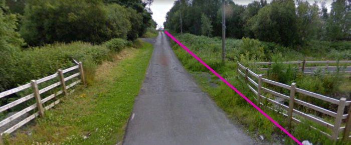
 The road and railway run parallel for some distance, turning to the northeast.
 This Google Streetview image shows the point where road and rail diverge slightly for a relatively short distance as seen on the satellite image above. The satellite images in these posts about the C&L are Google images with the route of the line super-imposed on them by railmaponline.com. [5]
 The old line continued on the South side of the road and crossed the road between Drumgildra and Bornacoola at level.
 The crossing keeper’s cottage still stands (above). This view looks back from the road in a westerly direction towards Dromod. The route of the old line is marked in ‘pink’. The view is nothing but undergrowth in the Easterly direction.
The adjacent image shows the location of the first station along the line – Derreen Station. The line has turned to the Northeast and runs straight for some distance before entering the Station complex. Derreen Station was about 2.5 miles from Dromod. Derreen Station: Locomotive No.6T pauses at the station on 24th March 1959 in the last week of the line’s operational existence with the afternoon train from Ballinamore to Dromod. The station building was on the Northwest side of the line. [7: p10]


 The station building stills stands, reasonably well camouflaged from the road. This view (above) from the North shows both the road and station building in the 21st century, The line ran behind the building in the photograph. Google Earth’s definition at this location is not great but the building can just be picked out among the pixels on the adjacent small satellite image!
The adjacent 1940s OS Map extract (GSGS One-inch) shows the location of the station and the route of the line ahead. In a relatively short distance it turns almost due North.
The photograph below is taken at the point where road and rail use to converge, South of Drumard Lough on the OS Map and central to the satellite image below. The farm access road travels along the formation of the C&L at this point.
Ahead, road and old rail route diverge. The road heads away towards Rinn Lough to the East, the railway headed North. Flanagan describes the line out of Dromod as far as Mohill like this: “Leaving the station, the line took a long sweep to the north-west [actually the North-east] past Clooncolry gates. The section to Derreen (2.5 miles) undulated through poor boggy land, the only gradients of note being two short stretches of 1:41 and one of 1:60. The halt at Derreen was typical of the ‘flag stations’ in having a halt-keeper’s cottage and small passenger shelter on a low stone-faced (down side) platform. However, the shelter was not erected until about 1900 and, at the start, facilities were very primitive indeed; in August 1888, when passengers complained of the lack of a shelter, the only concession made was to improve the method of access — till then, two planks across a ditch! The halt was at first to be named ‘Lough Rhyn’ as the road which the line crossed there did, in fact, lead to Lough Rinn. Continuing, the line was more or less level all the way to Mohill, although there was a short fall from Derreen at 1:49. On the way, the line crossed Tawnaghmore Bog and passed Clooncahir, where trains stopped on demand for Mr Digges on way to meetings, before entering Mohill (5.75 miles). This is a sizeable town and the only place of importance in the region.” [1: p126-127]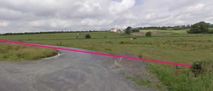

 Clooncahir appears at the top of the adjacent OS Map extract. The line continues only a short distance further North, sinuously curveing firat towatrds the East and then back towards the North, before entering the village of Mohill.
The station at Mohill was sited on the South side of the village, adjacent to the road which approached the village from Rinn Lough. After curving to the East, the line crossed an access road on the level. No gates were provided at this location. It can be seen north of Clooncahir as the main road and the old railway came a little closer together.
From this point, as we have noted, the line curved North and entered Mohill Station.
Mohill Station still stands. The National Inventory of Architectural Heritage describes it like this: A “detached three-bay two-storey triple-pile former railway station, with five-bay single-storey block to north end and return to rear, built c.1885 by the Cavan and Leitrim Railway. … Pitched slate roofs with brick chimney-stacks, round terracotta chimney pots and ridge cresting. Red brick walls with yellow and blue-grey brick dressings and eaves course. Segmental-headed openings with yellow-brick hood mouldings and timber sash windows. Timber double doors in north block flanked by glazing. Corrugated-iron outbuilding to east with decorative bargeboards and finials. Snecked stone goods shed with pitched slate roof to north, now in use as a builders’ providers premises.” [9] Looking back down the line towards Clooncahir.
 Looking forward towards Mohill.
 One of the reasons why Mohill was so important to the network was that it had a reliable and uncontaminated water supply. Rather than risk the water at Dromod, most services were detained at Mohill to enable the locomotives to top up their tanks. 4-4-0T No. 3 pauses for replenishment at Mohill on a train bound for Dromod in 1956, (c) Patrick Flanagan. [7: p12]
The North point on both of the next maps of Mohill Station is to the right of the image. The second image was drawn by Patrick Flanagan. [6]

 Mohill Railway Station in the years before the closure of the line. [10]
 Looking South into the station area from the level-crossing at the North end of the station site.
 From a similar position in the 21st century.
 A composite ‘then and now’ image produced by Reverb Studios. [11]
These next five pictures were taken of Mohill Station on 15th May 2019 by ‘dannyboy‘ on the N Gauge Forum and are included with permission. [6]


 This picture shows the platform and station frontage on 15th May 2019. The picture is taekn from the north end of the platform. [6]
 This picture shows the forecourt side of the station building, taken from the north end as well. [6]


 Four images of Mohill Good Shed taken a number of years earlier. [6]
References
- Patrick J. Flanagan; The Cavan & Leitrim Railway; Pan Books, London, 1972.
- The Irish OSM Community Map; http://maps.openstreetmap.ie/oocmaps.html?zoom=15&lat=53.86144972982129&lon=-7.916875406754906&layers=B0000TFFFFF, accessed on 9th May 2019.
- http://www.huntleyachives.com; Film 96365, accessed on 10th May 2019.
- http://catalogue.nli.ie/Collection/vtls000148612/CollectionList?lookfor=&filter%5B%5D=geographic_facet%3A”Leitrim+(County)”, accessed on 9th May 2019.
- http://www.railmaponline.com, accessed on 6th May 2019.
- https://www.ngaugeforum.co.uk, accessed on 16th May 2019.
- Tom Ferris & Patrick Flanagan; The Cavan & Leitrim Railway – The last Decade – An Irish Railway Pictorial; Midland Publishing Ltd., Leicester, 1997.
- https://www.tripadvisor.com.ph/LocationPhotoDirectLink-g1184756-d3570987-i65004244-Cavan_Leitrim_Railway-Dromod_County_Leitrim_Western_Ireland.html, accessed on 19th May 2019.
- http://www.buildingsofireland.ie/niah/search.jsp?type=record&county=LE®no=30816030, accessed on 19th May 2019.
- https://www.leitrimobserver.ie/news/home/282178/mohill-s-railway-station-will-be-turned-into-a-cinema-for-a-unique-event-this-sunday.html, accessed on 19th May 2019.
- https://blog.reverbstudios.ie/2018/10/05/mohill-railway-station-leitrim-then-and-now, accessed on 19th May.

I am very interested in Cavan &Leitrim railway. Your coverage is most interesting and well presented. Thanks Gerry.
Thank you!
really amazing information here – thank you for sharing it.
The preservation society is rebuilding the line out of Dromod at the moment!