

[NB: As far as I am aware permission has been granted for the use of all the photographs below. I have sought, where-ever possible to attribute all sources and have no intention of contravening copyright. Should there be an issue with any of the images below, if you are the copyright holder, please contact me. Please accept my apologies in advance if this has occurred.]
The Ogawa Forest Railway
The 762mm line south from Agematsu was known as the Ogawa Forest Railway. A small part of this line has been preserved as the ‘Ohtaki Forest Railway’ at the Akazawa Railway Memorial Hall.  Agematsu in the 1960s. [5]

 There is an interesting feature in Agematsu which I have discovered on-line. [27] There was a short link line between the high-level railway station and yards and the sawmill in the Kiso River Valley floor. It included a sharp loop as shown in the adjacent image at position ‘A’. [27]
The adjacent image shows at least part of the line still in place in the 1960s. It was very steeply graded and required a very sharp curve to gain the lower level where the sawmill was placed. [28]

 The location of the loop is shown above. The adjacent sketch shows it most clearly. [27]
Trains from Agematsu which intended to follow the Ogawa line followed the route north out of Agematsu and crossed the Kiso River using the same bridge as those heading up the Ohtaki Valley. Once over the river, the trains would reverse to take the Ogawa Line.
 The Ogawa Line travelled South down the West side of the Kiso River. By the mid-1970s there was little evidence that it had been there. The red arrow above shows the route taken by the line from Onibuchi. [1]
Trains ran south for a kilometre or so. The first part of the route can be picked out on the adjacent map close to the Ogawa River. The JNR Chuo line is visible in the top right corner of the map. Initially, the formation has been turned into a modern, tarmacked, single-lane road. The first image below shows the tracks still in position in around 1970. [3] It passes the hydroelectric scheme opposite Agematsu across the Kiso River, bridging the water supply pipes (as can be seen below).
 The railway then turned gently westward into the valley of the River Ogawa and ran along the North side of the valley. The map below shows the extent of the various routes associated with the Ogawa Forest Railway. The main routes are shown red-dotted on the plan.
 The Ogawa Forest Railway routes are shown red-dotted on the plan above. [2]
The route of the railway followed this road. [2]
The road meets the highway No. 473 and the line follows that for a short distance before dropping away to the left as shown below.
 This picture shows this location in September 1982, (c) Teruo Hayashi. At that time the route of the old line was clearly visible form the main road. Although that road itself was much narrower! [4]
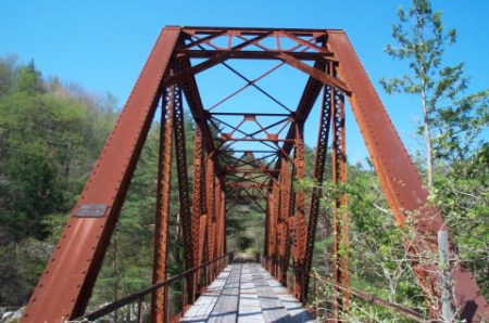
 Shortly after this the railway crossed form the North to the South side of the Ogawa River on the Odano Railway Bridge. The bridge remains in position in the early 20th century as the satellite image above and the adjacent photograph show. [2][29]
The track-bed beyond the bridge is gradually becoming overgrown as these next two images show. [2][6]
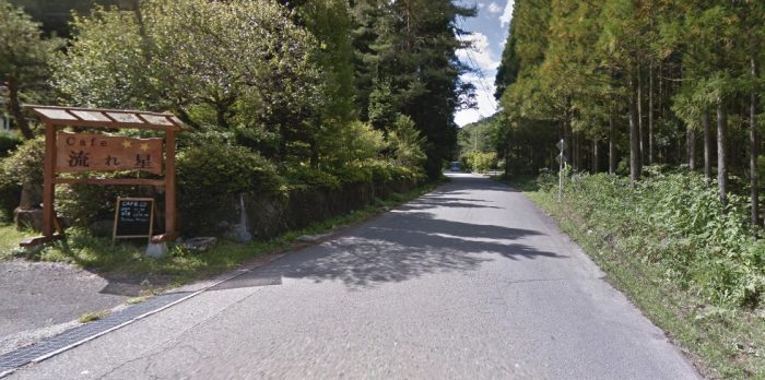
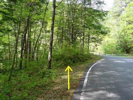
The Ogawa Forest Railway continues to follow the South side of the valley for some kiloemetres. Its route can be accessed easily where modern roads cross its path. This Google Streetview image looks back along the line towards Agematsu.
 The route continues on, parallel to the river.
 It passes through a number of old station sites on the way. These included Takakura which was located at a crossing point on the Ogawa River.
 The route of the line approaching Takakura can easily be picked out on the satellite image above.
At Takakura, a bridge marks that spot of the station today. The present concrete bridge may itself be old enough to have been in place when the railway was in use. If not so, there are signs of the abutments of a previous structure at this location. [7] Takakura Bridge. [7]
 Looking back along the line of the railway toward Agematsu from Takakura Bridge. The road on the left is the old railway route.
 Looking ahead along the old railway at Takakura Bridge.
 The map above shows the next section of the journey from Takakura (the red dot on the right of the map). [8]
The adjacent image shows the state of the track-bed beyond Takakura. [9]
The route of the old railway line once again meets tarmac close to Yakisoba Station.

 The image above looks forward along the line towards Yakisoba Station.
The adjacent picture shows the lumber yard which now sits on the approximate location of the station at Yakisoba (Yakisasa) [10] where the line turns to the south and crosses the Ogawa River once again, as shown below. 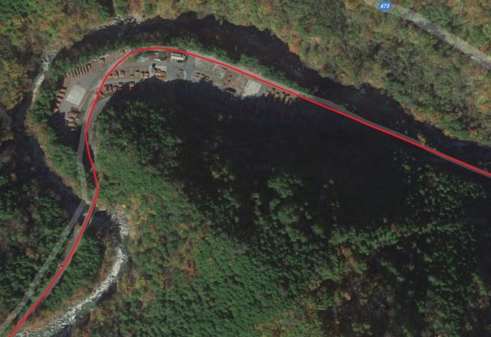
 The bridge over the Owaga River just to the south of the timber yard (Google Streetview).
Once across the above bridge and now on the West bank of the River Ogawa, the line travelled in a southerly direction. Its route is now under the tarmac of a forest road.
 The next station along the line was Naka Nakao. Two railway bridges spanned the creek on the North side of the River. The station was on a reversing spur as shown above. The modern road runs along the lower of the two lines. The remains of the upper bridge can be seen in the Google Streetview image below.
 Trains had to reverse over this bridge. [13] The old railway line then ran above the modern road as it headed on.
A schematic plan of the complex track arrangement over the next part of the line is shown below.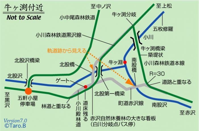 This schematic plan shows the Akasawa line crossing the Ogawa River on the right side of the map. [15]
 The Akasawa line follows the yellow line to the left. The line towards Kurosawa followed the modern road. [20]
 The line to Akasawa crossed the Ogawa River at this point. The bridge piers remain. This is the Ushikabuchi Bridge. [16]
 The wider area around the confluence of the two rivers. [19]
The Akasawa line led to what is now the Akasawa Forest Railway in the Akasawa Natural Recreational Forest via Ushiguchi and Hinomiya. It is this line that we will follow first.
Once the Ushikabuchi Bridge had been negotiated, trains ran along the eastern side of the river valley as shown above.
 The railway formation now lies under the road to Akasawa.
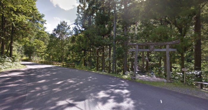
 Between rail/road and river we pass the entrance to the Himemiya Shrine.
 The shrine relates to a princess who dived into a pool in the river, (c) Ken Matsu. [17]
 The river pool, (c)110 nari. [21]
 This map shows the planned walking routes around the Akasawa Centre and the route of the Forest Railway at the Centre. [22]
 The original track layout at Akasawa, in schematic form. [25]
The following pictures show the line from Akasawa terminal to Maruyamado Terminus further to the South. The first four images show the terminal buildings at Akasawa. All are taken from Google Streetview. View firm the Car park.
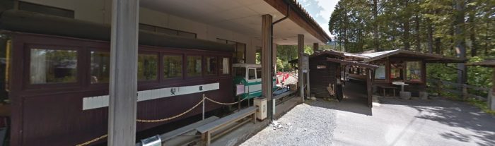 Station Entrance.
 Locomotive Sheds.
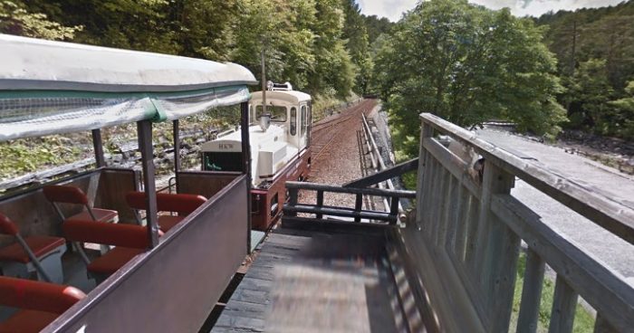 The route ahead.
 A model of the same location. [23]
 Looking back towards Akasawa.
 Looking forward towards Maruyamado Terminus from the same location.
 Two shots from further along the line!
 Just missed the train to Maruyamado Terminus.
 Entering Maruyamado Terminus.
 At the far end of the terminus station the railway branches in two. To the right is a stub end to allow locomotives to run round their train ready for the return journey to Akasawa. The line to the left continues into the forest but is now only used for storage.
 A diesel locomotive has run round its train and then pushed the train back beyond the terminus station. [14]
In 2017, Masato Chinu undertook some exploration in the area of the terminus station where a line leaves the tourist line. The line extends some distance into the forest. Its route is the line deviating to the left in the image above. Along the first section some old vehicles are stored. [14]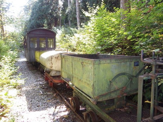
 On 13th October 2017 these items of rolling stock were stored on the branch. [14]
 The line continued for some distance. Scaffold boarding has in places been used to make walking along the route easier. [14]
 The line continued for at least 2 kilometres into the forest and probably much further. [14]
 After about an hour’s walking Masato Chinu retracted his steps to Maruyamado Terminus Station. [14]
 Train en-route back to Akasawa. [24]
 Two shots taken inside the loco shed/display hall at the museum at Akasawa. [26]
Having covered the Line to Akasawa, we return to the route to Kurosawa.
Just after the Akasawa Line split from the Kurosawa Line, the railway route to Kurosawa deviated from the modern road as shown by the yellow arrow in the adjacent picture. [20] Then the railway crossed the Ogawa River once again. The railway bridge piers can be seen alongside the forest road bridge in the Google Street view image below.
 The bridge abutments can be seen on the Streeview photograph above and on the adjacent image. [11]
Once over the river, the railway turned to the right and continued alongside the Ogawa River.


 The Kurosawa Line is now a gravel-surfaced forest road that runs parallel to the Hokutozawa River.
The next location on the route translates to English as ‘Five Store Cabin Stop’ (五軒小屋停車場). There was a junction at this point, the Naka Nakao Line left the Kurosawa line and crossed the Hokutozawa River.
The bridge has deteriorated badly. It was converted to a footbridge on its abutments and beams. The ‘footbridge’ was in a very poor state of repair in 2004. It was the only way of crossing the river at this point to get to the Naka Nakao Line beyond.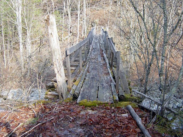
 Two pictures of the Hokutozawa bridge, in a state of decay in 2004, with a ‘temporary’ footbridge placed over it. [30]
The present Hokutozawa bridge replaced an earlier timber bridge whose abutments are still visible from the river. [30]
Naka Nakao Line continued deep into the forest above the Ogawa Forest Railway. Along its route it was possible to look down on all the railway lines in the immediate vicinity. Just beyond the bridge the track was supported by a small retaining wall. [40]

 A short distance further from the bridge a section of the old track-bed has collapsed into the river.
Once this length has been negotiated, the track-bed can be followed relatively easily. A couple of pictures of the route are provided here from a set of pictures on the Rintetsu website. [31]
The pictures were taken at different times in 2004 and 2011 but are typical of the condition of the more minor logging railway routes nearly half-a-century after closure.
Returning to the Kurosawa line, the formation of the old railway continues to be covered by a gravel forest road. Along the journey we pass a picturesque waterfall, which can be seen from the old track-bed -see the second image below. The Kurosawa Line continues to head West along the river valley. This picture was taken in May 2009. [32]
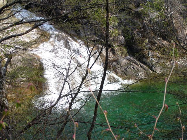 Otaru Waterfall. [33]
 The Forest road bridge over the Kisame Kisawa. [34]
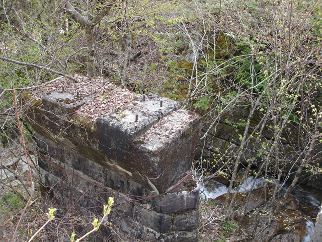 The old railway bridge sat alongside the forest road bridge. The first railway bridge at this site was a timber structure which was later replaced by a bridge made of two iron girders. [34]
 Nasayama bridge over the Hokutozawa River. This bridge was built in 1964 after the removal of the old railway bridge in 1962. [35]
The railway continued for some considerable distance to Kurosawa. The formation remained under the modern gravel forest road. At Kurosawa (黒沢) the railway switched back on itself to gain height as shown on the plan below. Kurosawa (黒沢) is on the right-hand side of the map. [36]
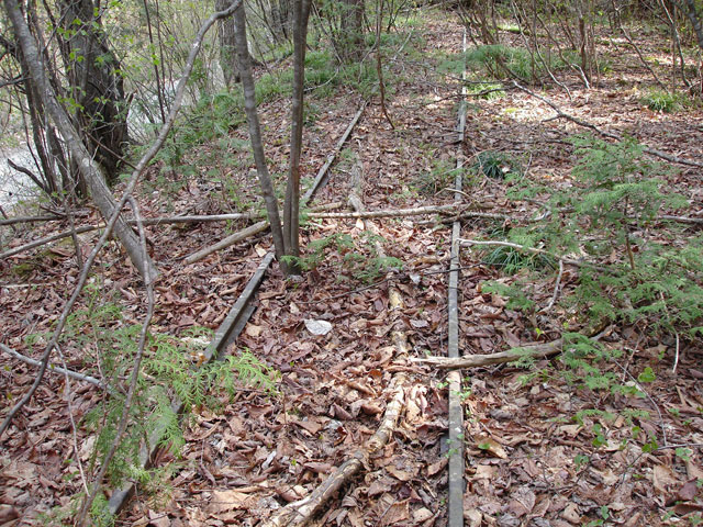 Traces of track-work at Kurosawa. [37]
Beyond Kurosawa, the railway continued to follow the river valley higher into the mountains. Two tight hairpin bends were necessary. [38]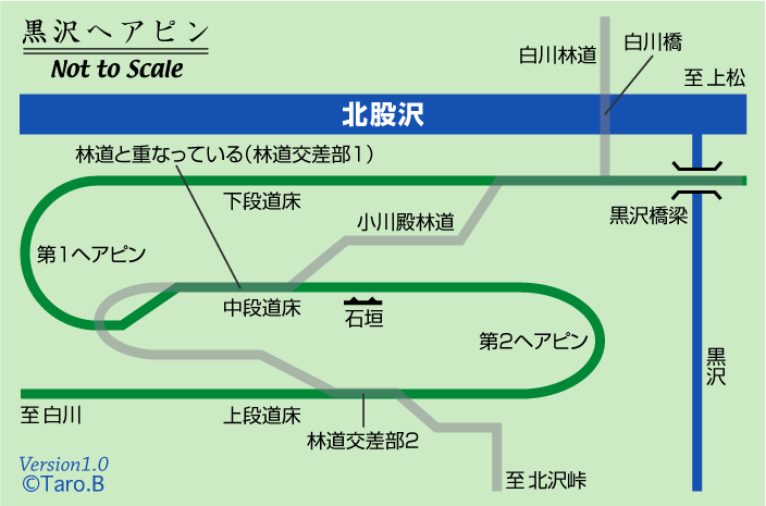 Beyond the hairpins, the route of the railway becomes increasingly indistinct. [39]
 The route of the Line is shown by the yellow arrow. [39]
It is clear that the Line continued some distance into the forest from this point but its route is relatively indistinct. The track can be followed further in the links provided at reference [41] below.
References
- http://tsushima-keibendo.a.la9.jp/kiso/onibuchi1.html, accessed on 9th February 2019.
- http://www.soleil1969.com/ruinstop/ogawa/oga001.html, accessed on 17th February 2019.
- http://rintetsu.net/nagano_01/ogawa04/ogawa_28.html, accessed on 17th February 2019.
- http://rintetsu.net/nagano_01/ogawa05/ogawa_33.html, accessed on 17th February 2019.
- http://www.cnet-kiso.ne.jp/h/harahiro/kiso/haisen.html, accessed on 17th February 2019.
- http://rintetsu.net/nagano_01/ogawa06/ogawa_42.html, accessed on 17th February 2019.
- http://rintetsu.net/nagano_01/ogawa07/ogawa_49.html, accessed on 17th February 2019.
- http://rintetsu.net/nagano_01/ogawa07/ogawa_map4.html, accessed on 17th February 2019.
- http://www.soleil1969.com/ruinstop/ogawa/oga003.html, accessed on 17th February 2019.
- http://www.soleil1969.com/ruinstop/ogawa/oga004.html, accessed on 17th February 2019.
- http://www.soleil1969.com/ruinstop/ogawa/oga005.html, accessed on 18th February 2019.
- http://rintetsu.net/nagano_01/konakao01/konakao01.html, accessed on 18th February 2019.
- http://uguigawa.blog42.fc2.com/blog-entry-412.html, accessed on 18th February 2019.
- https://blogs.yahoo.co.jp/masatochinu/42145179.html, accessed on 10th February 2019.
- http://rintetsu.net/nagano_01/ogawa10/ogawa_85.html, accessed on 18th February 2019.
- http://rintetsu.net/nagano_01/ogawa09/ogawa_84.html, accessed on 18th February 2019.
- https://www.google.co.uk/maps/@35.758142,137.620113,3a,75y,90t/data=!3m8!1e2!3m6!1sAF1QipMXL-Jex6LLlKgqWdrzdswbDOFRdwpU7m_OheV2!2e10!3e12!6shttps:%2F%2Flh5.googleusercontent.com%2Fp%2FAF1QipMXL-Jex6LLlKgqWdrzdswbDOFRdwpU7m_OheV2%3Dw203-h134-k-no!7i1500!8i997, accessed on 19th February 2019.
- http://tsushima-keibendo.a.la9.jp/kiso/kiso-map.html, accessed on 10th February 2019.
- http://rintetsu.net/nagano_01/ogawa09/ogawa_map5.html, accessed on 18th February 2019.
- http://rintetsu.net/nagano_01/kurosawa01/kurosawa_01.html, accessed on 19th February 2019.
- https://www.google.co.uk/maps/@35.7582246,137.6219955,3a,75y,90t/data=!3m8!1e2!3m6!1sAF1QipOQnjJoz_VO_QPrpMogMJpcHcyMsFGV4f0YMRGq!2e10!3e12!6shttps:%2F%2Flh5.googleusercontent.com%2Fp%2FAF1QipOQnjJoz_VO_QPrpMogMJpcHcyMsFGV4f0YMRGq%3Dw203-h152-k-no!7i1024!8i768, accessed on 19th February 2019.
- http://www.avis.ne.jp/~hinoki/en/akasawamap.pdf, accessed on 19th February 2019.
- http://www.kiso-mc.com/blog/index.php?c=3-20, accessed on 20th February 2019.
- https://go-centraljapan.jp/route/monozukuri/en/10.html, accessed on 20th February 2019.
- http://rintetsu.net/nagano_01/akasawa2/akasawa_10.html, accessed on 20th February 2019.
- https://tokutomimasaki.com/2015/09/trip_to_nagano_in_summer_2015_24.html, accessed on 20th February 2019.
- https://sakurayamalr.at.webry.info/201612/article_5.html, accessed on 20th February 2019.
- http://www.kisoji.kiso.nagano.jp/harahiro/kiso/haisen.html, accessed on 20th February 2019.
- http://usa-nekosando.pupu.jp/miti_otano.b.html, accessed on 20th February 2019.
- http://rintetsu.net/nagano_01/konakao01/konakao01.html, accessed on 21st February 2019.
- http://rintetsu.net/nagano_01/konakao02/konakao08.html to http://rintetsu.net/nagano_01/konakao02/konakao24.html, all accessed on 21st February 2019.
- http://rintetsu.net/nagano_01/kurosawa02/kurosawa_07.html, accessed on 21st February 2019.
- http://rintetsu.net/nagano_01/kurosawa02/kurosawa_08.html, accessed on 21st February 2019.
- http://rintetsu.net/nagano_01/kurosawa02/kurosawa_09.html, accessed on 21st February 2019.
- http://rintetsu.net/nagano_01/kurosawa02/kurosawa_11.html, accessed on 21st February 2019.
- http://rintetsu.net/nagano_01/kurosawa04/kurosawa2_map1.html, accessed on 21st February 2019.
- http://rintetsu.net/nagano_01/kurosawa03/kurosawa_17.html, accessed on 21st February 2019.
- http://rintetsu.net/nagano_01/kurosawa05/kurosawa2_09.html, accessed on 21st February 2019.
- http://rintetsu.net/nagano_01/kurosawa05/kurosawa2_12.html, accessed on 21st February 2019.
- http://www.geocities.co.jp/SilkRoad-Desert/8044/ko.htm, accessed on 21st February 2019.
- http://rintetsu.net/nagano_01/kurosawa06/kurosawa2_13.html to http://rintetsu.net/nagano_01/kurosawa06/kurosawa2_30.html, all accessed on 21st February 2019.

Fascinating, Roger. Does this mean I can assume a knowledge of the Japanese language as one of your achievments?
Sorry Tony, I have made use of translation software when necessary.