
The Route of the Ashover Light Railway – Stretton to Ashover Butts
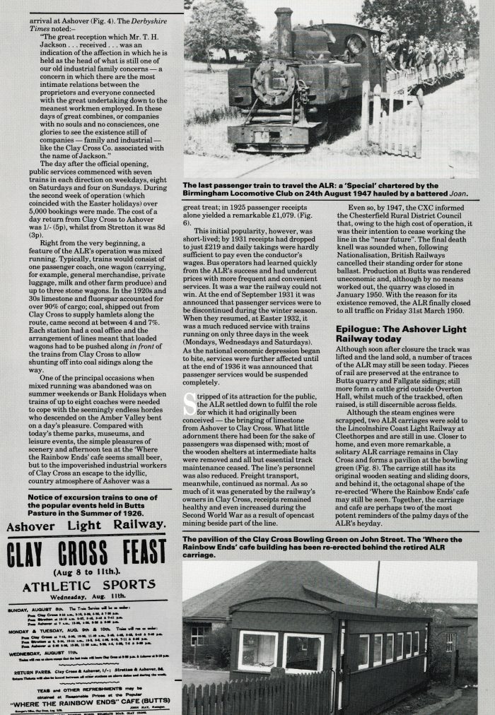
 Baldwin 4-6-0T ‘Joan’ at Stretton in 1930. [5]
 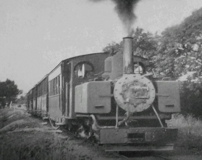 Joan heading South from Stretton, (c) M. W. Earley [6]
South of the Halt at Stretton, the railway travelled for well over a kilometre alongside the main standard-gauge line before it began to bear away from the Midland line towards the west, soon entering the valley of the River Amber. The next halt was at Hurst Lane, but there was an intermediate passing loop for stabling purposes at Ford.
Ford Loop was “the lowest point on the railway. In the early days a steam locomotive would wait here ready to pilot heavy stone trains to Clay Cross, but objection was made to the weight on the bridges and subsequently the engine was attached to the rear of the train as a banker. Years later the morning stone from Ashover would drop half its load here and collect it in the afternoon.” [4]
Beyond Ford Loop, wagons of coal for nearby Ogston Hall could be accommodated in a siding alongside Ford Lane. Ogston Hall. [15]
The line climbed steadily at a grade of 1 in 220 on its journey to Hurst Lane which was provided with facilities for trains in both directions to take water simultaneously.[2] It had a wooden shelter and telephone box, together with a water tank on wooden trestles. There were points for a siding near the shelter, but this was never laid. The water tank was gone by the late 1940s. [1][7]
Beyond Hurst Lane, the gradient of the line steepened to 1 in 99, wooded slopes which surround the line in the lowest part of the valley gave way to open country as the railway ran on towards Woolley. Along the route of the line, bridges were used to allow the line to remain on an acceptable alignment despite to meanderings of the River Amber. Just before reaching Woolley and after crossing the river on a bridge, the line passed what could have been the location of its main junction. Within the original authorisation for the construction of the line was a route to Alton Colliery. Although authorised, this line was never built. [8]

Alton Colliery was not re-opened. K.P. Plant notes: “Examination of the Deposited Plans shows that the branch would have had a continuous climb to the colliery from its junction … west of Hurst Lane. Traffic would have been worked on the endless rope principle and, as level crossings were vetoed, extra expense would have been incurred in providing 5 road bridges. The order restricted the gradient on the branch to 1 in 10, the minimum radius of curves to 5 chains, and not surprisingly prohibited it to passenger traffic.” [9]
By this time, the surrounding countryside was more hilly.
At Woolley, the next halt, a public road was crossed, and goods facilities were provided. This halt, and those at Dalebank and Milltown, took their names from hamlets on the hillside. In most cases passengers were also picked up and set down wherever public roads were crossed.
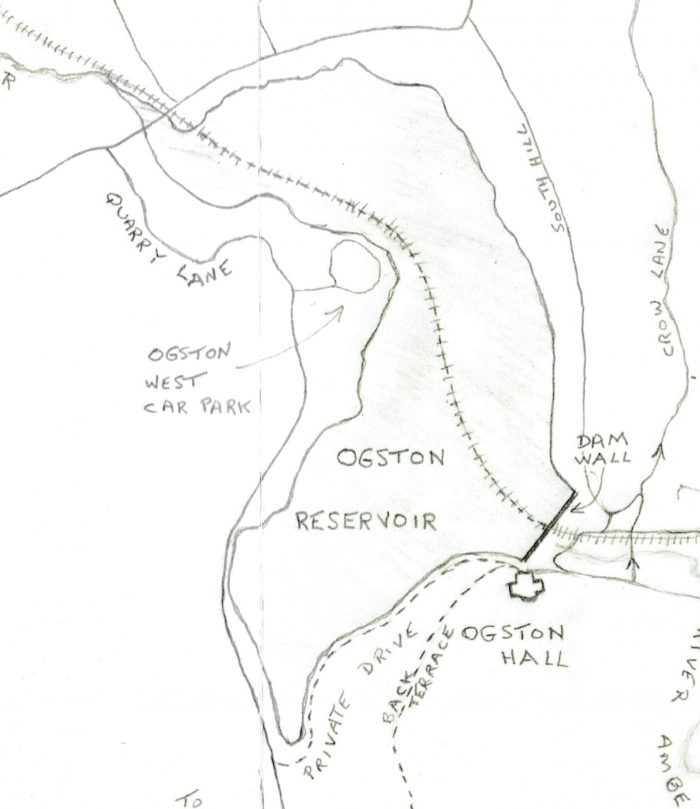 Woolley Halt comprised “the usual shelter, together with a telephone box, plate-layers cabin and Clay Cross Company coal office (closed about 1934) and a siding to hold four or five wagons.” [7] The Halt served the village of Woolley Moor. Some time before its closure, the telephone was moved from the box into the office, as coal sales were initially good, but soon deteriorated. The section of track where the station once stood has now been flooded by the Ogston Reservoir. [1] The sketch plan above [14] shows the line of the Light Railway and the extent of the reservoir. The railway route only appears out of the water just to the southeast of what is now the B6014 and had it survived, the line would have followed the lake shore to the right of the image below.
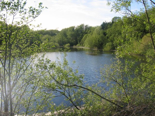 This northwestern tip of Ogston Reservoir is cut off from the main reservoir by the B6014. This is where the River Amber joins the reservoir, its course can be seen when water levels are low. [13]
Beyond Woolley trees encroached on the line again and the railway crossed the Amber two times as it continued to climb up the valley. The next halt was Dale Bank Halt, which had a wooden shelter. The halt was always very underused, despite being just half a mile from Stubben Edge Hall. [7] Stubben Edge Hall. [16]
A further 500 metres or so up the line the railway crossed a small bridge and arrived at Milltown Halt. Provision was originally made here for a siding but one was not built. The points were removed at the beginning of the 1930s. [7] The halt was reach via a short roadway from Oakstedge Lane. [1]
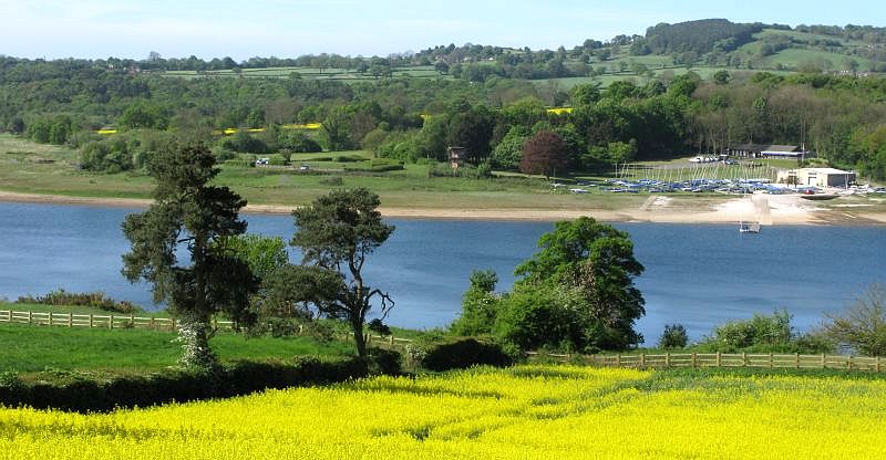
Before leaving the lower end of the Amber Valley, it is worth a note about the reservoir which now floods much of the area. Ogston Reservoir was completed in 1958 and dramatically altered the appearance of the Amber Valley. Today (2019) it is regarded positively and has become a magnate for birds. [12] The reservoir was originally created to supply the National Coal Board’s Carbonisation Plant at Wingerworth but is now run by Severn Trent Water and supplies water for the local area and is used as a holding ground for water for nearby Carsington Reservoir. It has an area of 220 acres of open water, holds 1300 million gallons of water and gets its water from the River Amber. [10]
The flooding of the valley in 1958, completely submerged farmland, roads and part of the Ashover Light Railway. The reservoir also destroyed most of the village of Woolley. The villagers were relocated into council houses built in another local hamlet, Badger Lane, which eventually became known as the village of Woolley on the Moor, which subsequently became the present village of Woolley Moor. [10]
 Local feelings in the late 1950s are highlighted in an article written at the time by Mrs Annie Fox. [11] she draws attention to the changing scene after the building of the dam. Her words are in italics:
In days gone by, Woolley House a large Country house was run as a Hydro and took in visitors all the year round. Attached to it was a small village store where you could buy anything from a box of matches to a cwt: of corn. In the yard at the back was the old Joiners shop, which was used by the local undertaker.
Later the house was sold and divided up into 6 small cottages made out of the big house, the shop 11 other cottages and the old public house Napoleon’s Home, all will soon be destroyed by the New Ogston Reservoir built to supply industry with millions of gallons of water.
The Napoleon’s Home has been in the family of the Fox’s for generations past, and is still bother owned and run by Mr Fox today. In its grounds the village football team used to play, also the cricket team had their pitch. Here the Flower and Vegetable Show has been held every year for the past 48 years. Now they are told it cannot stay. The villagers have to leave homes in which some were born, and lived for a life, time, to make way for the flooding of the valley. At present only the Public House remains occupied. When the bulldozers have finished their work, one cottage on the other side of the road will remain, standing out like a landmark with the past. Its occupant an old gentleman who has seen many changes in his life time, now spends a lot of time directing many and various people up the hill, to where the villagers have been re-housed in Council houses, almost making a new village on top of the hill. Before, only a few cottages and small holdings stood there.
The old sheep wash too, has been destroyed where local farmers used to bring their sheep for washing. The bridge across the river is being raised; cranes, concrete mixers and bulldozers spoil the quiet countryside.
At one side of the river at this point stood the laundry where washing from both Woolley Hydro and Stubbin Edge Hall was done.
On the other side of the river stood a house built by a local man named Beresford, also his Blacksmiths shop, where both he and his man worked regularly.
Across the river set out among spacious lawns was Amber Valley Camp School. Built in 1939 to give 250 children from urban areas the benefit of having a month’s education in rural surroundings. During the war, it was used to re-house a Public School evacuated from Derby. This too will soon be swept away by bulldozers to make way for the rising waters.
At the other side of the valley stand the Pumping Station, and the Purifying plant.
On top of the spur stood a large Georgian house know as The Ford House. In its lovely grounds also stood the Gardeners and Butlers cottages, these too have been swept away, to make way for the modern dwellings to house reservoir officials. On the other side of the road, in a large meadow, stands another group of new houses built for reservoir staff.
At the bottom of the valley by the side of the river used to run a footpath. Over 30 years ago a then young school mistress took a class of infants on a picnic into a field which the footpath ran through by the river, that day has never been forgotten. They fished they played cricket, and drank milk and tea carried from a Farm House up on top of the hill 4 steep fields away. What a day they had – no more will do it. Now the same field lies 30 feet under water, only memories are left. But to those who took part in it, it stands out as one of the most wonderful days of childhood.
The old Mill too has gone. It used to be driven by a water wheel and was well known for miles around. No more will carts take rough stone in at one side of the yard and sawn blocks out at the other.
In the past the valley was one of Derbyshire’s beauty spots, a lovely place in summer, but forgotten in winter. What will it be now?
In the early 21st Century, Ogston Reservoir provides many leisure activities including sailing, windsurfing and trout fishing. There have been 200 species of bird life recorded at Ogston including Wilson’s phalarope, Sabine’s gull and long-tailed skuas. There are two observation hides used by local bird watchers.
The present sailing club building which can be viewed from the field was originally the Amber Valley Camp School. It was built in 1939 to give 250 children from urban areas the benefit of have a months education in rural surroundings. [10] It seems, with the benefit of hindsight, that Mrs Fox’s fears have not been borne out, despite what has been lost.
We are now some distance up the line from the northwestern end of the reservoir.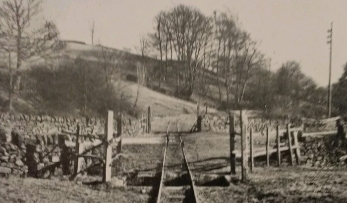 One of the most picturesque stretches of the line was in the vicinity of the halt at Dale Bank where the wooden shelter formerly stood on the left of the above photograph beyond the road. The pit in the foreground replaced the original wooden cattle guards, © K.P. Plant (4th March 1951). [6]
The gradient eased beyond Dale Bank. The line passed the Miners Arms on the left and turned northwards into a deep cutting and then passed a fluorspar washing plant and sidings. One of those sidings climbed to the Clay Cross limestone quarry. Although close to Fallgate station the quarry was known as the Milltown Quarry. [17]
The next stop on the line was Fallgate. Fallgate was an important mineral traffic centre, with short branches to quarries and their associated electric power station, and extensive siding accommodation (as we have already noted). Here, also, were additional locomotive and carriage sheds. [2] The station/halt served the hamlet of Fallgate. It had a wooden shelter, a telephone box and a water tank. The station stood at the north end of a 100-yard loop adjacent to a level crossing. There was also a coal sales depot, and in 1927, a limestone dust grinding plant was built. However, due to repeated complaints by local residents, the plant was dismantled and moved to the Clay Cross Works. A tarmacadam plant was also built, operating from 1936 to 1948. [1][17]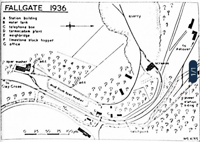 This excellent drawing (badly scanned) is taken from the 1965 edition of K.P. Plant’s book on the Ashover Light Railway. In interpreting the plan it is important to remember that North is to the righthand-side of the plan. [18]
On the above plan, the Fluorspar washing plant is to the left, and the line from Clay Cross enters from the left just below the plant. The route to the quarry runs north and the line onwards to Ashover heads off to the right side of the plan. The power station is close to the River Amber on the right side of the image, it can just be seen to the right of the (1/1).
The location has been the subject of a superb 009 model which, while foreshortening some distances has been as faithful as possible to the location. The layout is called: “Fallgate: Ashover Light Railway.” It was created by Brian Love, a member of the 009 Society, and since 1998 it has been extensively exhibited throughout Southern and Eastern England. It is now owned by Stephen Little and Matthew Barrett and is based in Manchester. [19] The track plan of the 009 layout – Fallgate. The Fluorspar Washer is on the top-left of the track plan with the tarmac plant in the middle-right opposite the station building. The two lines to the right of the track plan represent the line into the quarry and the line on to Ashover repectively. [19]
 The model of the Fluorspar Washer, (c) Stephen Little. [19]
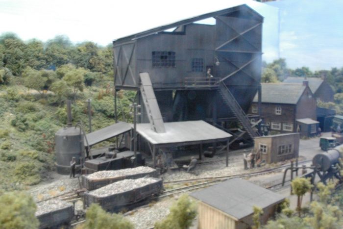 The model of the Tarmas plant with the timber station building in the foreground, (c) Stephen Little. [19]
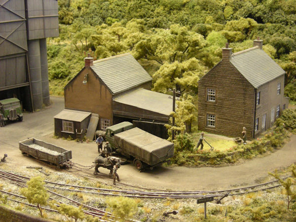 The model of the cottages at Fallgate, (c) Stephen Little. [19]
 Fallgate Station before the construction of the Tarmacadam plant which sat beyond the timber station shelter on the left of the image. [23]
The tracks in the immediate vicinity of Fallgate station were not lifted at the same time as the rest of the Ashover Light Railway. They remained in place late into the 1960s serving the quarrying operation at the site. Indeed, as can be seen in the photograph below, some sections of track have survived into the 21st Century.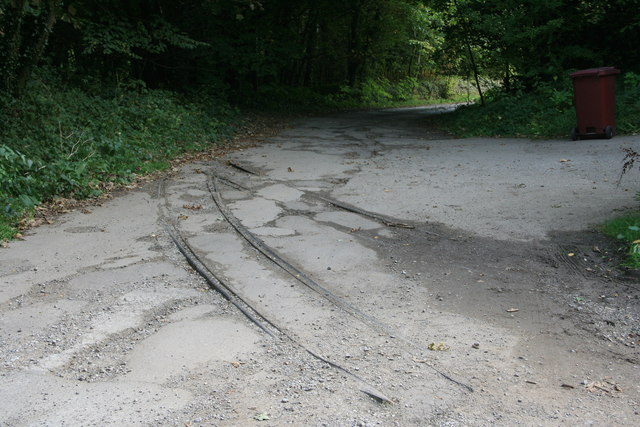 Railway lines in the track leading to Milltown/Fallgate/Felbrigg Quarry, (c) Graham Hogg. [21]
 The formation of the Ashover Light Railway remained in use at Fallgate into the late 1960s as a works railway operating in the immediate vicinity of the Washing Plant and the old station as is shown in this drawing from Plant’s book about the Ashover Light Railway. [28]
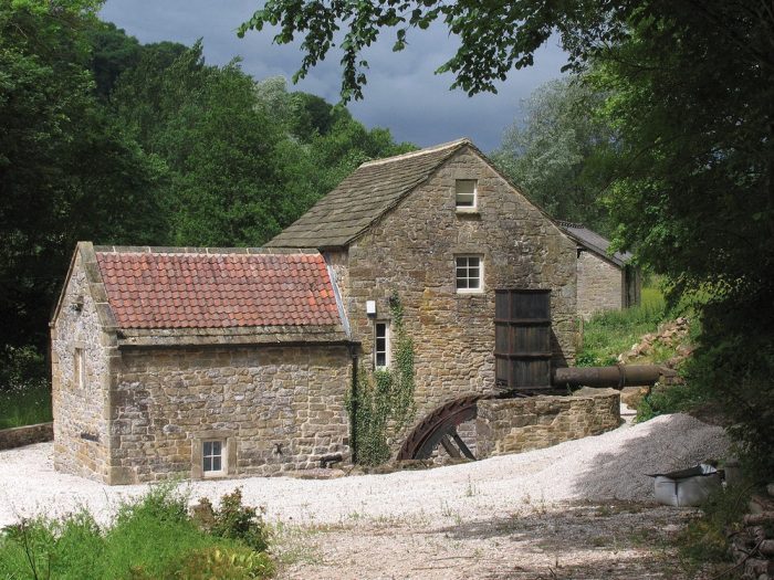
 Fluorspar Crushing Mill at Fallgate, recently refurbished. [20]
The adjacent Google Earth satellite image shows the approximate route of the railway through Fallgate and the location of the small station building.
The railway formation ran on the West side of the River Amber through the halt and then followed what is now a lane called Jetting Street.
At the North side of the station a horse-worked branch line ran up a 1 in 13 gradient to a set of the screens and loading hoppers which were fed from a high level line out of the adjacent quarry. [17]
Along that length of the valley, the railway passed the Fallgate power house which was sited on the opposite bank of the River Amber. It had stone walls and a red asbestos roof. The power house supplied electricity to the Clay Cross Company quarries. [24]
 Milltown/Felbrigg/Fallgate Quarry. [22]
Along this length of the line, trains also passed an old mill and water wheel. That mill is shown in a refurbished condition above. It was a water-powered corn mill. Dated 1781, but with earlier work incorporated within the present structure. It was restored in 1987-8. A restored overshot wheel with metal sideplates and timber buckets was set into the wheelpit. A metal pentrough delivers water to the wheel head. The interior of the mill and the machinery have been fully restored. [25]
Salter Lane, the next halt, was the nearest to the main part of Ashover town, but the line continued to a triangular junction, used for turning purposes, with the spur leading to the passenger terminus at Ashover (Butts), near the old and historic parish church. [2]
Salter Lane (for Ashover) was just half a mile from Overton Hall. It consisted of a low platform with a wooden shelter and a nameboard. The shelter is no longer present, but the edge of the platform is still visible. [1]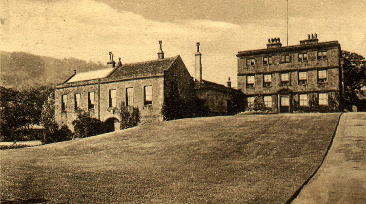 Overton Hall was once the home of the naturalist Sir Joseph Banks. [27]
 Overton Hall was, from 1942, certified to operate as an approved school for boys. It served in this capacity until 1948, not long before the Ashover Light Railway closed. From 1950 to 1956, it operated as a youth hostel. Later it served as an old people’s home. In the early 21st Century, it is now a private residence. [26]
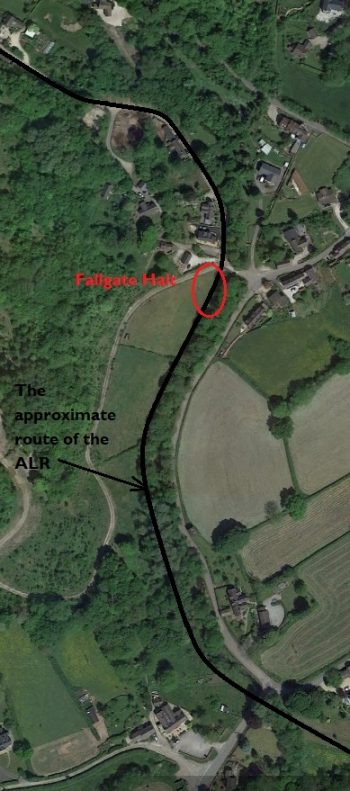
 Salter Lane can be made out on the above map at the point where it crosses the route of the ALR South of Ashover. It was the closest stop to the village.
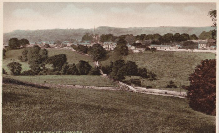 The proximity of the Salter Lane Halt (right of middle in the image) to the village of Ashover is illustrated above. [34]
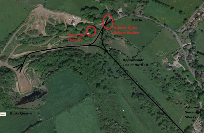 The end of the line.
Ashover Butts had a single platform with a wooden building, which comprised an open-fronted shelter with an office on either side, one of which was for ticket sales. The other office briefly sold confectionery, but then stood unused for many years. Latterly, it was used to store moulds from the Butts concrete plant.[29] In the last couple of years before passenger services ended, the building was painted grey. [1][30] The station building is shown in the first image below.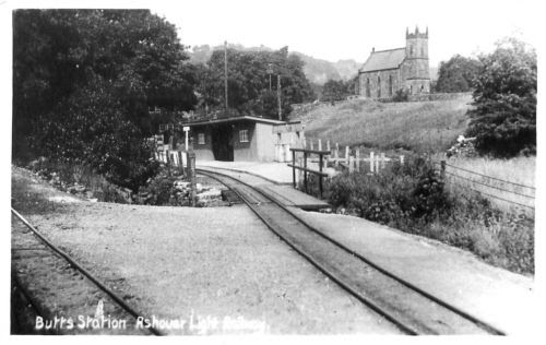 Ashover Butts railway Station. [31]
 An overview of Ashover Butts Station. [33]
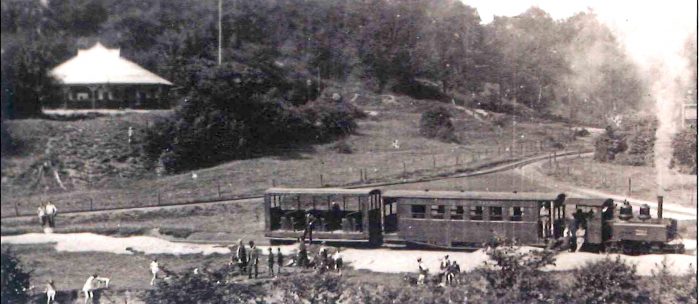 Ashover Butts Satation was on the lineheading off to the top right of this image. The train, in the capable of 4-6-0 Baldwin, ‘Joan’, is using the triangle to turn ready for a trip back to Clay Cross Works via Stretton. The round peaked building to the top left of the image was a cafe built for tourists travelling on the ALR – the ‘Where the Rainbow Ends’ Cafe [32]
 Another view of the Cafe. [34]
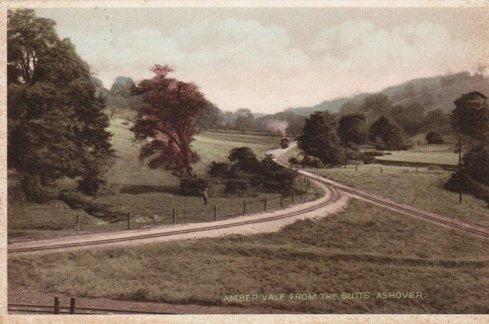 A view back down the line towards Stretton taken from close to the ‘Where the Rainbow Ends’ Cafe. [34]
The base of the triangle was extended to Butts Quarry further up the valley. The Google Earth satellite image above shows the approximate line of that extension. The Quarry is now the site of a MotoX track. [35]
The triangle at Ashover Butts was replicated at Clay Cross. These triangles meant that trains could be maintained intact with the locomotives running chimney first, in which conditions the type in use performed most efficiently. Also, as they were 4-6-0 tank engines, it was advantageous for negotiating the sharp curves on the line to have the bogie leading. [2]
 To complete our journey along the line, it is worth noting that Wild Swan published a book about the Ashover Light Railway. The book was written by Stewart R. Band and Robert Gratton and published in 1989. [36]
BackTrack Magazine carried an article written by Tim Warner on the Ashover Light Railway in its May/June 1992 issue. A copy of the article is produced below the references section. [37]
Julian Holland has a chapter about the line in his book, “Discovering Britain’s Little Trains. [38]
References
- https://en.m.wikipedia.org/wiki/Ashover_Light_Railway, accessed on 13th January 2018.
- The Ashover Light Railway; The Railway Magazine, Volume 96, No. 593, September 1950.
- http://www.alrs.org.uk/site/?page_id=31, accessed on 14th January 2019.
- K.P. Plant; The Ashover Light Railway. The Oakwood Press, 1965, p44.
- https://www.pinterest.com/pin/374221050282986254, accessed on 23rd January 2019.
- K.P. Plant; The Ashover Light Railway. The Oakwood Press, 1965, pictures between p44 and p45.
- K.P. Plant; The Ashover Light Railway. The Oakwood Press, 1965, p45.
- Ibid., p4 & p10.
- Ibid., p11-12.
- http://www.derbyshireuk.net/ogston_reservoir.html, accessed on 26th January 2019.
- http://www.strettonhandley.derbyshire.sch.uk/oldwebsite/areservoirtakesitstoll.html, accessed on 26th January 2019.
- http://www.ogstonbirdclub.co.uk, accessed on 26th January 2019.
- https://en.wikipedia.org/wiki/Ogston_Reservoir, accessed on 26th January 2019.
- The Ashover Light Railway Society, Short Walks on a Railway Theme – Walk Number 3, Country Estates and Waterworks, Stretton to Ogston.
- https://www.brackenfield.org/ogston-hall-visit-picnic-at-the-hall#&gid=347&pid=1, accessed on 26th January 2019.
- http://m.ipernity.com/#/doc/buildings/25566191, accessed on 26th January 2019.
- K.P. Plant, op. cit., p46.
- Ibid., p37.
- http://www.stephenelittle.com/fallgate/#layout, accessed on 27th January 2019.
- http://m.ipernity.com/#/doc/302581/45025008, accessed on 27th January 2019.
- https://www.geograph.org.uk/photo/3861366, accessed on 27th January 2019.
- https://www.geograph.org.uk/photo/1855664, accessed on 27th January 2019.
- http://www.ashover.org/photo107.htm, accessed on 27th January 2019.
- K.P. Plant, op. cit., p47.
- https://historicengland.org.uk/listing/the-list/list-entry/1241794, accessed on 27th January 2019.
- http://www.childrenshomes.org.uk/AshoverAS, accessed on 27th January 2019.
- http://www.ashover.org/photo130.htm, accessed on 27th January 2019.
- K.P. Plant, op. cit., p47.
- Ibid., p48.
- https://en.m.wikipedia.org/wiki/Ashover_Butts_railway_station, accessed on 28th January 2019.
- http://railthing.blogspot.com/2014/01/ashover-light-railway.html, accessed on 28th January 2019.
- https://www.pinterest.co.uk/pin/131871095323434925/?lp=true, accessed on 28th January 2019.
- https://www.ebay.co.uk/bhp/ashover-light-railway, accessed on 28th January 2019.
- https://picclick.co.uk/Set-of-12-Ashover-Light-Railway-Postcards-original-273663372391.html, accessed on 28th January 2019.
- https://www.facebook.com/pages/Butts-Quarry-MotoX-Track/119689744810650, accessed on 28th January 2019.
- Stewart R. Band and Robert Gratton; The Ashover Light Railway; Wild Swan, Didcot, 1989.
- Tim Warner; BackTrack Magazine, Volume 6, No.3, May/June 1992, p127-129.
- Julian Holland; Discovering Britain’s Little Trains; AA Publishing, Basingstoke, 2008, p56-69.


I was born in a little cottage at Spoilbanks down Clay Lane right alongside the A L R line.Started work at C X C at the age of 14 and started on the A L R with grumpy old Tommy Whiston then moved to the fitting shop and worked as a boy with Cliff Salt..After a while I moved on to Diesel maintenance. Our first workshop was the old A L R Clay Cross station. I remember all the old Baldwin,s being cut up for scrap. I did the maintenance on the Planet Diesel and would sometimes do the run to Ashover if the driver didn’t turn up.
If we did any maintenance we would take it for a test run as far as the Royal Oak in Clay Lane…..
On one trip I found the diesel in Ffesttiniog and they have named it Ashover.
I am in my 90s and moved to New Zealand in 1957… I love to go to your site and reminisce.
Very Happy days…. Harry Spencer.
Dear Harry, thank you for your very kind words and the memories you have shared. I am really glad that you are finding the site valuable. My very best wishes. Roger.
Pingback: Light Railways in the UK – the early years after the 1896 Act – The Railway Magazine, August 1905. … | Roger Farnworth