
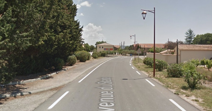
The Tramway Station at Siran was Northeast of the old town centre on the site of what is now a fire-station. The location can be picked out on the Google Earth Satellite image below to the northeast of the roundabout in the top right of the image. The line ran to the rear of the white roofed building and the station building was located under the same building. The line ran behind the ‘Cave’ which can just be seen at the top right of the image.
 Approaching the Station from the West.
 The tramway ran to the North side of the road along a line just in front of the bushes at the left of this picture and crossed the accommodation road to pass between the two buildings evident to the right of centre in the picture.
 The tramway passed between these two buildings. This picture is taken from roughly the same position as the older image below. [1]
 This image is taken from the approximate location of the modern roundabout on the D168E4 and looks to the North. [2]
In the image below, the tramway continues behind the ‘Cave’ which ids the low long building on the right. the Tramway alignment is running parallel to the IC68 (D168) which can be found on the south side of the ‘Cave’ and is shown in the second image below.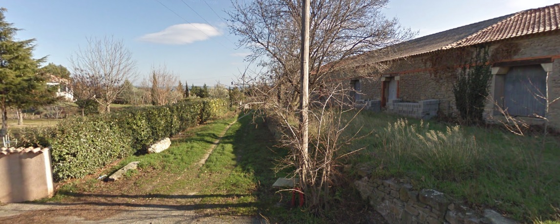
 From Siran, the Tramway travelled on the Northside of the IC68 (D168) to Cesseras. As far as I can ascertain, the tramway ran on a raised embankment on the North side of the road, as shown below.
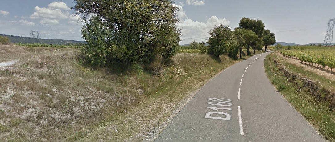
 This image shows the remains of a tramway bridge over a stream. Old abutments and one beam are visible.
 The approach to Cesseras. The tramway is still on the north side of the D168 (IC68). The slight embankment to the left of the road shows the tramway alignment. The station at Cesseras is just beyond the building ahead on the left of the road.
 A hundred metres or so closer to the village the old station building can still be seen in the early 21st century.
 The Tramway Station building in Cesseras was encountered just before the trams entered the village. The image above attempts to produce a similar view to the adjacent earlier image. [3] The platform has been removed and a bench provided.
 This view looks back from Cesseras towards Siran. [4]
 A similar view of the station building in the early 21st century.
The village of Cesseras retains vestiges of its ramparts (towers and curtain walls). It also has some old houses (mullioned windows) and elements of the old castle, dismantled from the Revolution: two round towers, one crowned with a glazed tile roof. The station building can just be picked out on the bottom edge of the satellite image below to the left of the D168. The tramway continued in an easterly direction through the village on the IC68 (D168). The route is easily seen in the satellite images above and below.
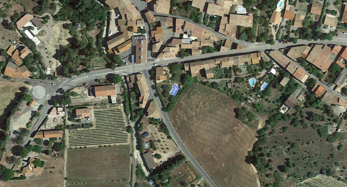
 Beyond the village of Cesseras, the tramway followed a generally easterly path through vineyards towards Azillanet, still running on the North shoulder of the IC68 (D168). The main road by-passed Azillanet to the South and the tramway followed it, crossing the road into the village and then running on the southwest side of what became the D168. The old tramway crossed the River Tay on the right side of the bridge in the foreground of the picture below. And when the road turned East, the tramway continued in a southeasterly direction into the tramway station site. The old station building can still be seen beyond the central bridge railings.
 The station building at Azillanet.
 Azillanet station looking back towards Cesseras. [5]
After Azillanet the GC10 (nowadays the D10) followed a southerly path, wandering through vineyards towards Beaufort. The tramway shadowed the GC10 on its western shoulder until the GC68 (D168) branched off towards Beaufort. The tramway then followed the southwestern shoulder of the GC68 to Beaufort. The lay-by to the right of the road is on the approximate line of the tramway.
 The D168 is the left-hand road. The tramway followed its right-hand shoulder as can be seen below. Again, vineyards are very much in evidence.
 The satellite image above shows the tramway alignment as it approached Beaufort. The green (grass) to the west of the road at the top of the image is the tramway route. On reaching the village cemetery, the tramway moved into the centre of the GS68 (D1680 and shared space with road traffic for a short distance and then slipped back to the southwestern shoulder. Vineyards still dominate the landscape.
 At the village boundary sign the road (on the left above) and the tramway crossed the Ruisseau de Beaufort on small independent bridges. The tramway bridge is in an excellent state of repair as can be seen below. [6]

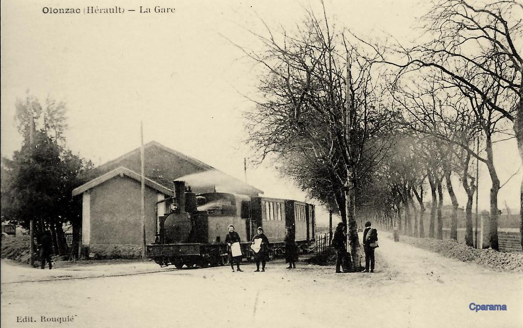
 The tramway then left the road to cross on the south side of the village of Beaufort before crossing the road to Olonzac – the GC 20 (D910). The route of the tramway has been converted into a minor road – Rue de l’Ancienne Gare. The monochrome postcard view below shows the old station in its heyday. A passing loop was provided along with a small station building. The old station site is now an area for playing boules/petanque. Beyond the station the line crossed followed the route to Olonzac (the GC20 (D910)) for a few hundred metres before heading across the fields towards Oupia.


 The satellite image and the picture above show the point of deviation of the tramway from the GC20 (D910). The photograph is taken at a point on the red line in the satellite image close to the top of that picture. The satellite image then shows the tramway route to Oupia Station which was some way from the village of Oupia (of which a portion is visible on the right-hand side of the satellite image. The adjacent photos show first, the state of the station of Oupia in the early 21st Century and second, the station in use. [7]
On the way to the station of Oupia, trams crossed two girder bridges with 15 metre spans over the streams of Oupia and Escut. These bridges were demolished and sold in around 1948. The abutments remain [7]. After the station the tramway followed the route of the modern D52E2 towards Olonzac. Nowadays there is a roundabout at the point where the tramway encountered the GC20 (D910) at its junction with the GC70 (D52).
The tramway route round Olonzac is now covered by the D52E1 which forms a by-pass on the southeastern side of Olonzac. From the poisiton of the present roundabout the tramway headed southwest and crossed the River Espene almost immediately. The satellite image below shows the whole town of Olonzac. The next image focusses in on the South side of the town. The tramway arrangement in the town are shown schematically. The town was for a time the terminus of the line. After crossing the River Ognon to the South of the town trams first encountered the main Olonzac Station highlighted by the first blue oval. The line continued into the town to a point just South of the War Memorial where there was a small wooden platform which formed the terminus station of Olonzac City. The main tramway facilities were to be found at the station in the suburbs. It included a passenger building, a large hall with dock, a shed for equipment, a water intake and a dormitory for staff. [7]

 The green line on the satellite image above approximates to the route of the tramway arriving from Beaufort, Cesseras and Siran.
The adjacent image shows the station which was at the bottom of the satellite image above. [7]
The next image is of Olonzac City Station close to the War Memorial in the centre of the town. [7] And it is followed by a postcard showing that town centre line in operation. [8]

The adjacent image shows the same length of line, this time with a maintenance train in view. [7]
The next three historic images show the more southerly station in use. [8] 

 After leaving the main Station in Olonzac, trams soon crossed the River Ognon on a masonry Arch Viaduct as below. The viaduct was close to the town distillery, it was a three-arched road and tramway bridge, each arch was of 8 metres span. [7]
 The line has now turned southwards and as it leaves Olonzac soon exits Herault and returns to the Aude. It follows the GC10 (D910) to the departement boundary, and then the D2560 into Homps.
Just before reaching Homps the tramway and the road which is now the D2560 crossed the Canal du Midi.
Like Olonzac, Homps has grown since the days of the tramway. It stretches along the South side of the Canal.
The picture below is a satellite image of the village and Canal. The Station at Homps was on the North side of the Canal du Midi. It was a three-track station alongside the GC10. The location was at the top of the image below and to the right of the main road. The route from Olonzac enters the satellite image at the top and then curves round to pass over the Canal.
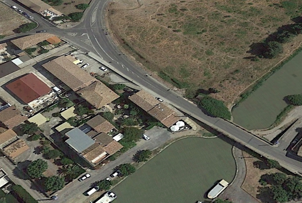
 This image is taken from the end of the retaining walls on the North side of the Canal. It shows Avenue de Minervois, looking towards Olonzac. It shows the location of the Station at Homps.
The earliest bridge over the Canal du Midi was a lattice girder bridge of the type seen in La Redorte, on the left of the postcard below.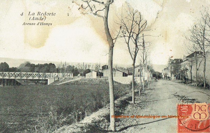
 The later replacement Canal bridge was a substantial structure as can be seen in the adjacent old postcard image. It was a 15 metre span which carried both road and tramway. Its approach retaining walls remain, but the superstructure has been replaced by a modern open- parapeted bridge of a slightly longer span.
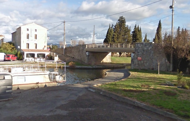

As an interesting aside, I came across this postcard while searching the internet. It is a complete flight of fancy as no standard gauge railway line ever served Homps!
The image on the postcard also seems to exaggerate the size of the village. A further search on the internet resulted in a series of postcards for different towns and villages all bearing the same image! This image was taken from close to the Canal bridge looking into Homps.
On leaving the old village of Homps the tramway followed the original GC5 (D611, which now-a-days joins the D610), before turning right down the GC11 (D611) and then crossing the River Aude on a masonry viaduct of three 20 metre-span arches. [7]
 The bridge over the River Aude taken in 2012 during the construction of the wier which improved the water supply to Tourouzelle. [10]
 The viaduct in 2016.
Immediately after crossing the bridge over the River Aude the trams encountered another Halt. The Halt/Station was close to the hamlet of La Tuilerie to the Northeast of Tourouzelle, and served Tourouzelle. [7][9]

 The image above shows the location of the Station for Tourouzelle. It is, in the 21st century, a kind of lay-by alongside the D611.
After the station at Tuilerie the tramway follows the northeast shoulder of the GC11 (D611) to Segame (Serame) and on to Montrabech on the GC11 (D11).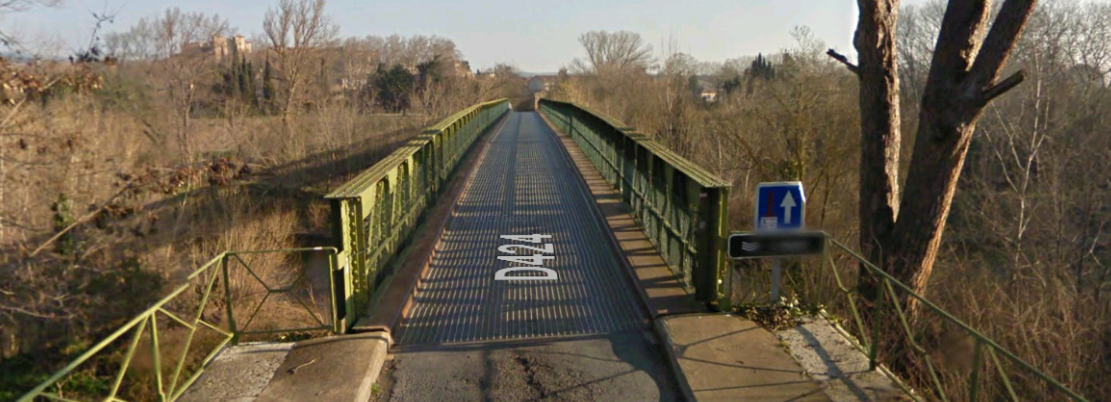
 Segame (Serame) was close to Argens-Minervois and Argens was connected to the tramway by a bridge over the River Aude.
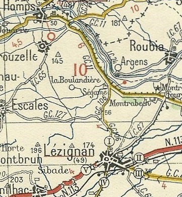
The Halt at Montrabech was known as Lezignan-Montrabech. It was to the East of the hamlet of Montrabech. The area of the Station is still visible on the satellite image below. The approximate rail alignment is also shown in red.
 The area of scrub land to the left of the D11, in between the vineyard and the road, is the location of the old station.
The tramway followed the eastern shoulder of the IC67 (D67 – Avenue Leon Bourgeois) into the northeastern outskirts of the town of Lezignan-Corbieres, usually known as Lezignan. It then drifted away from the road, following a line that approximates to the modern D6113 (Avenue Marechal Gallieni, which then becomes Avenue Marechal Lyautey.

 The image above shows the tramway’s tight turn from the IC67 to travel East. The buildings to the left of the tramway alignment were the site of the old Gendarmerie which appears in a couple of postcard images because a tramway halt could also be found at this location. [13]

 As we have already noted, after the station at the Gendarmerie the tramway took an easterly course along the line of the modern D6113 before turning southwards across some waste ground and then following the line of the present day Rue des Glycines and then to the West Southwest on Avenue Frederic Mistral before travelling to the South of that route and swinging round into Lezignan station. The orange line on the aerial image below shows that route entering from the top left. I am indebted to by Pascal_pmidi on the LRPresse Forum for this image. [16]
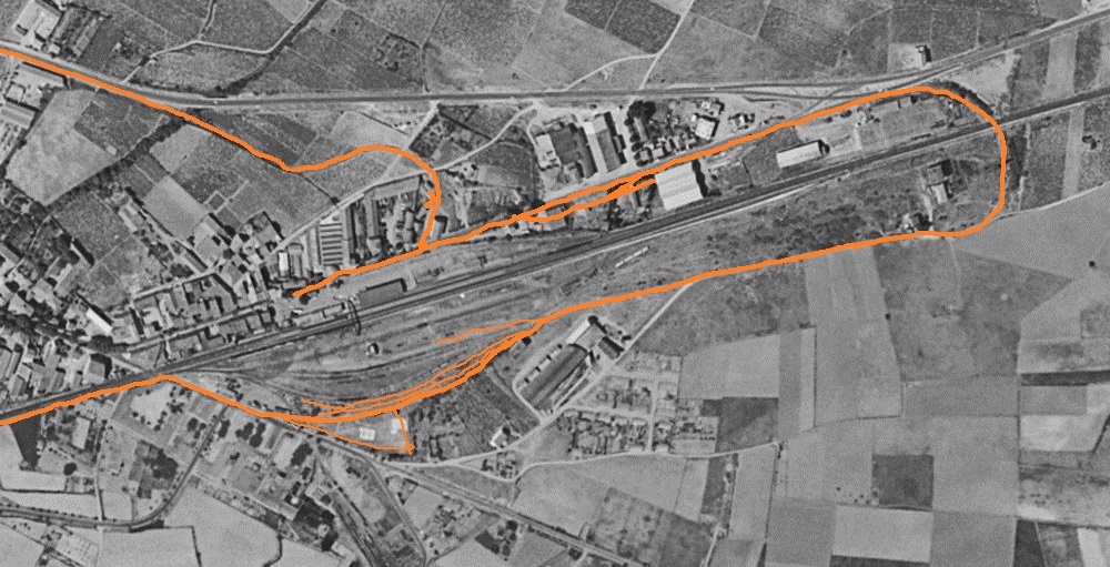
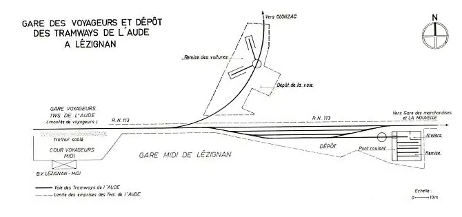 This sketch plan was made for the Magazine Loco Revue and shows the two lines approaching Lezignan Station. Comparing the two maps/plans it can be seen that one of the buildings accessed by turntable remains to be seen in the 21st Century. [15]
 One building remains from the loco depot shown on the plan above. This picture was taken in July 2017. [16]
The following pictures all show the terminus line of the tramway which ran parallel to the standard gauge line/sidings to the Gare du Midi aliong what was originally known as the Avenue de Narbonne. The line to the right runs immediately alongside the tramway. [14]
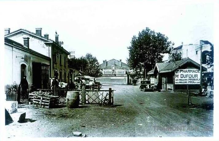 The low level building on the right is the station building for the tramway. [14]
 The building appears again in earlier days in this image with a track leading to what must have been interchange sidings behind the camera. [14]
 Both the Gare du Midi and the tramway station building appear in this image and the image below. [14]
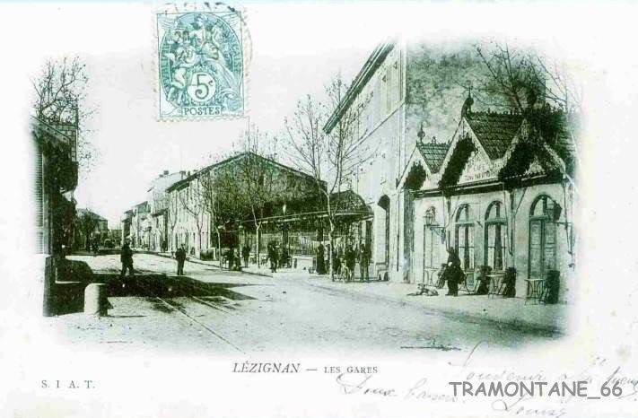
 The Avenue de Narbonne appears in the two images above. [11][13]


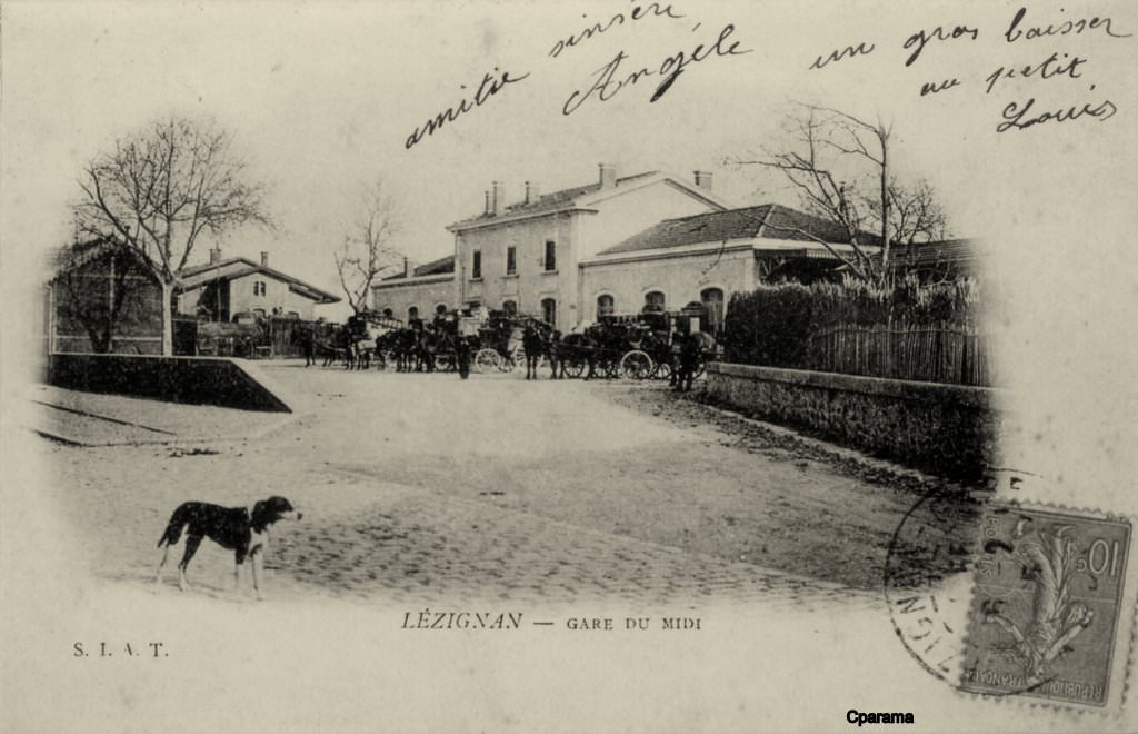


 The seven images above are all taken looking East along the Avenue de Narbonne and show the tramway station with the Gare du Midi behind. [13][14]
 This modern image shows the Gare du Midi forecourt as it is in the early 21st Century.
 The Gare du Midi forecourt above with the tramway station building in the middle right and the Grand Hotel across the Avenue de Narbonne. [14]
The adjacent image shows the two station buildings and the station forecourt. [7]
We finish this particular journey in Lezignan!
References
- https://www.delcampe.net/fr/cartes-postales/europe/france/34-herault/autres-communes?f=keyword:siran, accessed on 9th October 2018.
- https://www.communes.com/ville-siran-34, accessed on 9th October 2018.
- http://cahiers.de.minerve.pagesperso-orange.fr/HTML/cdf_lezignancaunes.html, accessed on 25th September 2018.
- https://www.delcampe.net/fr/cartes-postales/europe/france/34-herault/autres-communes?f=moyens-de-transport:transports, accessed on 12th October 2018.
- https://picclick.fr/Rare-Cpa-34-Herault-Azillanet-la-Gare-183374972512.html
- https://cahiers.de.minerve.pagesperso-orange.fr/HTML/cdf_hompsminerve.html, accessed on 13th October 2018.
- http://cahiers.de.minerve.pagesperso-orange.fr/HTML/cdf_lezignancarcassonne.html, accessed on 25th September 2018.
- https://www.cparama.com/forum/olonzac-t197.html, accessed on 13th October 2018.
- https://www.cparama.com/forum/tourouzelle-t266.html, accessed on 14th October 2018.
- https://www.lindependant.fr/2012/04/11/de-l-eau-de-l-aude-pour-alimenter-le-village,130415.php, accessed on 14th October 2018.
- https://www.cparama.com/forum/tourouzelle-t266.html, accessed on 15th October 2018.
- https://www.geneanet.org/cartes-postales/view/5928361#0, accessed on 15th October 2018.
- https://www.cparama.com/forum/lezignan-corbieres-gare-t28257-20.html, accessed on 15th October 2018.
- https://www.cparama.com/forum/lezignan-corbieres-gare-t28257.html, accessed on 15th October 2018.
- Loco Revue Volume No. 212 November 1961, p385.
- Aerial image provided with the line sketched by Pascal_pmidi on the LRPresse Forum on 1st December 2018.

Hello Roger, I was very interested to find your website as I am very interested in the Tramways d’Aude – I have a holiday home in Peyriac-Minervois. It is an excellent site and I look forward to doing my own exploring now I know where to look! One point of interest for you perhaps? A couple of years ago I visited a craft fair in Pepieux one November and met a chap who models OO gauge and lives in Lezignan. In your section on Lezignan, you show the route in red on a large scale plan of the eastern end of the town. Just south of the point where the line crossed the rue Turgot, are numbered buildings 1 and 4. He lives in the one marked 1 and on his property is the un-numbered, angled, building opposite the number 4. This angled building was the carriage shed for the tramway and he has built a mezzanine inside for his model railway, with the ground floor being converted into a Gite. So another building still survives, albeit modified internally. Should be able to find a view on Google streetview perhaps?
All the very best,
Russell Burridge
Hi Russell
Thanks for your comments. I have tried to follow this through on Streetview but the street view images stop short of the location on Rue Turgot and I cannot see what you mean from the street view images on the main road. However, what you say is certainly really interesting.
I am glad you appreciate the blog.
Best wishes
Roger
Pingback: Tramways de l’Aude – Lezignan-Corbieres to St. Pierre-des-Champs | Roger Farnworth